
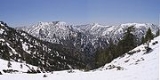
San Gabriel Mountains
Overview
Los Angeles County, California
Los Angeles County is a county in the U.S. state of California. As of 2010 U.S. Census, the county had a population of 9,818,605, making it the most populous county in the United States. Los Angeles County alone is more populous than 42 individual U.S. states...
and western San Bernardino County, California
San Bernardino County, California
San Bernardino County is a county in the U.S. state of California. As of the 2010 census, the population was 2,035,210, up from 1,709,434 as of the 2000 census...
, United States
United States
The United States of America is a federal constitutional republic comprising fifty states and a federal district...
. The mountain range lies between the Los Angeles Basin and the Mojave Desert
Mojave Desert
The Mojave Desert occupies a significant portion of southeastern California and smaller parts of central California, southern Nevada, southwestern Utah and northwestern Arizona, in the United States...
, with Interstate 5 to the west and Interstate 15 to the east. This Transverse Range lies in, and is surrounded by, the Angeles National Forest
Angeles National Forest
The Angeles National Forest of the U.S. National Forest Service is located in the San Gabriel Mountains of Los Angeles County, southern California. It was established on July 1, 1908, incorporating the first San Bernardino National Forest and parts of the former Santa Barbara and San Gabriel...
, with the San Andreas Fault
San Andreas Fault
The San Andreas Fault is a continental strike-slip fault that runs a length of roughly through California in the United States. The fault's motion is right-lateral strike-slip...
as the northern border of the range. The highest peak in the range is Mount San Antonio
Mount San Antonio
Mount San Antonio, commonly known as Old Baldy or Mt Baldy, at , is the highest peak in the San Gabriel Mountains, and the highest point in Los Angeles County...
, commonly referred to as Mt. Baldy. Mount Wilson
Mount Wilson (California)
Mount Wilson is one of the better known peaks in the San Gabriel Mountains, part of the Angeles National Forest in Los Angeles County, California. It is the location of the Mount Wilson Observatory and has become the astronomical center of Southern California with and telescopes, and and tall...
is another famous peak, famed for the Mount Wilson Observatory
Mount Wilson Observatory
The Mount Wilson Observatory is an astronomical observatory in Los Angeles County, California, United States. The MWO is located on Mount Wilson, a 5,715 foot peak in the San Gabriel Mountains near Pasadena, northeast of Los Angeles...
and the antenna farm
Antenna farm
Antenna farm or satellite dish farm or just dish farm are terms used to describe an area dedicated to television or radio telecommunications transmitting or receiving antenna equipment, such as C, Ku or Ka band satellite dish antennas, UHF/VHF/AM/FM transmitter towers or mobile cell towers.In...
that houses many of the transmitters for local media.