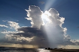
All Topics  
Cumulonimbus cloud

 
Cumulonimbus Cloud

   Email Print
   Bookmark   Link


Cumulonimbus cloud


Cumulonimbus (Cb) is a type of cloud
Cloud

A cloud is a visible mass of Drop or frozen crystals floating in the Celestial body atmosphere above the surface of the Earth or another planetary body....
 that is tall, dense, and involved in thunderstorm
Thunderstorm

File:FoggDam-NT.jpgA thunderstorm, also known as an electrical storm or a lightning storm, is a form of weather characterized by the presence of lightning and its effect: thunder....
s and other intense weather
Weather

Weather is a set of all the Phenomenon occurring in a given atmosphere at a given time. Weather phenomena lie in the hydrosphere and troposphere....
. It is a result of atmospheric instability. These clouds can form alone, in clusters, or along a cold front
Cold front

A cold front is defined as the leading edge of a cooler and drier mass of air, replacing a warmer mass of air.Development of cold front...
 in a squall
Squall

A squall is a sudden, sharp increase in wind speed which is usually associated with active weather, such as rain showers, thunderstorms, or heavy snow....
 line. They create lightning throught the heart of the cloud. Cumulonimbus clouds form from cumulus cloud
Cumulus cloud

Cumulus clouds are a type of cloud with noticeable vertical development and clearly defined edges. Cumulus means "heap" or "pile" in Latin. These are often described as "puffy" or "cotton-like" in appearance, cumulus clouds may appear alone, in lines, or in clusters....
s (namely from cumulus congestus
Cumulus congestus cloud

Cumulus congestus clouds are characteristic of unstable areas of the Earth's atmosphere which are undergoing convection. They are often characterized by sharp outlines and great vertical development....
) and can further develop into a supercell
Supercell

A supercell is a thunderstorm that is characterized by the presence of a mesocyclone; a deep, continuously-rotating vertical draft. Of the four classifications of thunderstorms , supercells are the largest and have the potential to be the most severe....
, a severe thunderstorm with special features.

lonimbus clouds usually form from cumulus clouds at a much lower height, thus making them, like cumulus clouds, grow vertically instead of horizontally, thus giving the cumulonimbus its mushroom shape.


Discussion
Ask a question about 'Cumulonimbus cloud'
Start a new discussion about 'Cumulonimbus cloud'
Answer questions from other users
Full Discussion Forum


Recent Posts


Encyclopedia


Cumulonimbus (Cb) is a type of cloud
Cloud

A cloud is a visible mass of Drop or frozen crystals floating in the Celestial body atmosphere above the surface of the Earth or another planetary body....
 that is tall, dense, and involved in thunderstorm
Thunderstorm

File:FoggDam-NT.jpgA thunderstorm, also known as an electrical storm or a lightning storm, is a form of weather characterized by the presence of lightning and its effect: thunder....
s and other intense weather
Weather

Weather is a set of all the Phenomenon occurring in a given atmosphere at a given time. Weather phenomena lie in the hydrosphere and troposphere....
. It is a result of atmospheric instability. These clouds can form alone, in clusters, or along a cold front
Cold front

A cold front is defined as the leading edge of a cooler and drier mass of air, replacing a warmer mass of air.Development of cold front...
 in a squall
Squall

A squall is a sudden, sharp increase in wind speed which is usually associated with active weather, such as rain showers, thunderstorms, or heavy snow....
 line. They create lightning throught the heart of the cloud. Cumulonimbus clouds form from cumulus cloud
Cumulus cloud

Cumulus clouds are a type of cloud with noticeable vertical development and clearly defined edges. Cumulus means "heap" or "pile" in Latin. These are often described as "puffy" or "cotton-like" in appearance, cumulus clouds may appear alone, in lines, or in clusters....
s (namely from cumulus congestus
Cumulus congestus cloud

Cumulus congestus clouds are characteristic of unstable areas of the Earth's atmosphere which are undergoing convection. They are often characterized by sharp outlines and great vertical development....
) and can further develop into a supercell
Supercell

A supercell is a thunderstorm that is characterized by the presence of a mesocyclone; a deep, continuously-rotating vertical draft. Of the four classifications of thunderstorms , supercells are the largest and have the potential to be the most severe....
, a severe thunderstorm with special features.

Appearance

Wagga Cumulonimbus
Cumulonimbus Tav
Cumulonimbus clouds usually form from cumulus clouds at a much lower height, thus making them, like cumulus clouds, grow vertically instead of horizontally, thus giving the cumulonimbus its mushroom shape. The base of a cumulonimbus can be several miles across, and it can be tall enough to occupy middle as well as low altitude
Altitude

Altitude has multiple uses depending on the context in which it is used . As a general definition, altitude is a distance measurement, usually in the vertical or "up" direction, between a reference datum and a point or object....
s; though formed at an altitude of about 3,000 to 4,000 meters (10,000 to 10,000 feet), its peak can reach up to 23,000 meters (75,000 feet) in extreme cases. Typically, it peaks at a much lower height (usually up to 5,000 meters / 16,500 feet).. Well-developed cumulonimbus clouds are also characterized by a flat, anvil-like top (anvil dome), caused by straight line winds at the higher altitudes which shear off the top of the cloud, as well as by an inversion
Inversion (meteorology)

In meteorology, an inversion is a deviation from the normal change of an atmospheric property with altitude. It almost always refers to a temperature inversion, i.e., an increase in temperature with height, or to the layer within which such an increase occurs....
 over the thunderstorm caused by rising temperatures above the tropopause
Tropopause

The tropopause is the boundary in the Earth's atmosphere between the troposphere and the stratosphere. Going upward from the surface, it is the point where air ceases to cool with height, and becomes almost completely dry....
. This anvil shape can precede the main cloud structure for many miles, causing anvil lightning
Lightning

File:Blesk.jpgLightning is an Earth's atmosphere discharge of electricity usually accompanied by thunder, which typically occurs during thunderstorms, and sometimes during volcano or dust storms....
. This is the tallest of the clouds.

Species

  • Cumulonimbus arcus
  • Cumulonimbus calvus
    Cumulonimbus calvus

    Cumulonimbus calvus is a moderately tall cumulonimbus cloud which is capable of Precipitation , but has not yet reached the height where it forms into a cumulonimbus capillatus or cumulonimbus incus ....
     – cloud with puffy top, similar to cumulus congestus
    Cumulus congestus cloud

    Cumulus congestus clouds are characteristic of unstable areas of the Earth's atmosphere which are undergoing convection. They are often characterized by sharp outlines and great vertical development....
    , but larger;
  • Cumulonimbus capillatus – cloud with cirrus-like, fibrous-edged top;
  • Cumulonimbus incus
    Cumulonimbus incus

    A cumulonimbus incus is a cumulonimbus cloud which has reached the level of tropopause and has formed the characteristic flat, anvil-top shape....
     – subtype of Cumulonimbus capillatus, with flat anvil-like top.
  • Cumulonimbus mammatus
  • Cumulonimbus pannus
  • Cumulonimbus pileus
  • Cumulonimbus praecipitatio
  • Cumulonimbus tuba
  • Cumulonimbus velum
  • Cumulonimbus virga


Anvil Shaped Cumulus Panorama Edit Crop

Effects

Cumulonimbus Noaa Gov
Cumulonimbus storm cells can produce heavy rain
Rain

Rain is liquid precipitation . On Earth, it is the condensation of atmospheric water vapor into droplet heavy enough to fall, often making it to the surface....
 (particularly of a convective
Convection

Convection in the most general terms refers to the movement of molecules within fluids . Convection is one of the major modes of heat transfer and mass transfer....
 nature) and flash flood
Flash flood

A flash flood is a rapid flooding of geomorphic low-lying areas - washes, rivers and streams. It is caused by heavy rain associated with a thunderstorm, hurricane, or tropical storm....
ing, as well as straight-line winds. Most storm cells die after about 20 minutes, when the precipitation
Precipitation (meteorology)

File:MeanMonthlyP.gifIn meteorology, precipitation is any product of the condensation of Atmosphere water vapor that is deposited on the earth's surface....
 causes more downdraft than updraft, causing the energy to dissipate. If there is enough solar energy in the atmosphere
Earth's atmosphere

The Earth's atmosphere is a layer of gases surrounding the planet Earth that is retained by the Earth's gravity. Dry air contains roughly 78.08% nitrogen, 20.95% oxygen, 0.93% argon, 0.038% Carbon dioxide in the Earth's atmosphere, and trace amounts of other gases....
, however (on a hot summer's day, for example), the moisture from one storm cell can evaporate
Evaporation

Evaporation is the slow vaporization of a liquid and the reverse of condensation. A type of phase transition, it is the process by which molecules in a liquid State of matter spontaneously become gaseous ....
 rapidly—resulting in a new cell forming just a few miles from the former one. This can cause thunderstorms to last for several hours. This multicell cloud structure exists until cold downdraft preceding cumulonimbus at ground level flows before cloud at distance sufficient to disrupt updraft (5–10 kilometers). From this moment on, cumulonimbus cloud quickly degrades and dissipates, forming cirrus spissatus, dense anvil-like cirrus
Cirrus cloud

Cirrus clouds are characterized by thin, wisplike strands, often accompanied by tufts, leading to their common name of mare's tail. Sometimes these clouds are so extensive that they are virtually indistinguishable from one another, forming a sheet of cirrus called Cirrostratus cloud....
, stratocumulus diurnalis or stratocumulus vesperalis.

Cumulonimbus clouds sometimes form mammatus cloud
Mammatus cloud

Mammatus is a meteorology term applied to a cellular pattern of pouches hanging underneath the base of a cloud. The name "mammatus" is derived from the Latin mamma , due to the resemblance between the shape of these clouds and human female breasts....
s.

Cumulonimbus clouds contain severe convection currents, with very high, unpredictable winds, particularly in the vertical plane (updrafts and downdrafts). They are therefore extremely dangerous to aircraft
Aircraft

An aircraft is a vehicle which is able to flight by being supported by the air, or in general, the atmosphere, of a planet. Examples include balloons, airplanes and helicopters....
. Smaller, propeller-driven planes cannot cope with the conditions and must fly around them; larger jet aircraft fly over the smaller ones and around larger examples. Larger planes are also equipped with weather radar
Radar

Radar is a system that uses electromagnetic radiation waves to identify the range, altitude, direction, or speed of both moving and fixed objects such as aircraft, ships, motor vehicles, weather formations, and terrain....
 and wind shear
Wind shear

Wind shear, sometimes referred to as windshear or wind gradient, is a difference in wind wind speed and wind direction over a relatively short distance in the Earth's atmosphere....
 detectors to help guide them through, in the event that they need to pass through such clouds to land. They also can snow because they are also in the higher part of the atmosphere.

The air convection can also form mesocyclone
Mesocyclone

A mesocyclone is a vortex of air, approximately 2 to 10 km in diameter , within a convection storm.That is, it is air that rises and rotates around a vertical axis, usually in the same direction as low pressure systems in a given hemisphere....
s, which can cause hail
Hail

Hail is a form of Precipitation which consists of balls or irregular lumps of ice . Hailstones on Earth usually consist mostly of ice and measure between 5 and 150 millimeters in diameter, with the larger stones coming from severe thunderstorms....
 and tornado
Tornado

A tornado is a violent, rotating column of air which is in contact with both the surface of the earth and a cumulonimbus cloud or, in rare cases, the base of a cumulus cloud....
es.

See also

  • Cumulonimbus calvus
    Cumulonimbus calvus

    Cumulonimbus calvus is a moderately tall cumulonimbus cloud which is capable of Precipitation , but has not yet reached the height where it forms into a cumulonimbus capillatus or cumulonimbus incus ....
  • Cumulonimbus incus
    Cumulonimbus incus

    A cumulonimbus incus is a cumulonimbus cloud which has reached the level of tropopause and has formed the characteristic flat, anvil-top shape....
  • Cumulus congestus cloud
    Cumulus congestus cloud

    Cumulus congestus clouds are characteristic of unstable areas of the Earth's atmosphere which are undergoing convection. They are often characterized by sharp outlines and great vertical development....
  • Funnel cloud
    Funnel cloud

    A funnel cloud is a funnel-shaped cloud of condensed water droplets, associated with a rotating column of air and extending from the base of a cloud but not reaching the ground or a water surface....
  • Hot tower
    Hot tower

    A hot tower is a tropical cumulonimbus cloud that penetrates the tropopause, i.e. it reaches out of the lowest layer of the atmosphere, the troposphere, into the stratosphere....
  • Mammatus cloud
    Mammatus cloud

    Mammatus is a meteorology term applied to a cellular pattern of pouches hanging underneath the base of a cloud. The name "mammatus" is derived from the Latin mamma , due to the resemblance between the shape of these clouds and human female breasts....
  • Pileus
    Pileus (meteorology)

    A pileus is a small, horizontal cloud that can appear above a cumulus cloud or cumulonimbus cloud, giving the parent cloud a characteristic "hoodlike" appearance....
  • Pyrocumulonimbus
    Pyrocumulonimbus

    The pyrocumulonimbus cloud is a type of cumulus cloud formed above a source of heat such as a wildfire and may sometimes even extinguish the fire that formed it....
  • Squall line
    Squall

    A squall is a sudden, sharp increase in wind speed which is usually associated with active weather, such as rain showers, thunderstorms, or heavy snow....
  • Storm
    Storm

    A storm is any disturbed state of an astronomical body's Celestial body atmosphere, especially affecting its surface, and strongly implying severe weather....
  • Supercell
    Supercell

    A supercell is a thunderstorm that is characterized by the presence of a mesocyclone; a deep, continuously-rotating vertical draft. Of the four classifications of thunderstorms , supercells are the largest and have the potential to be the most severe....
  • Tornado
    Tornado

    A tornado is a violent, rotating column of air which is in contact with both the surface of the earth and a cumulonimbus cloud or, in rare cases, the base of a cumulus cloud....


External links