

Extratropical cyclone
Encyclopedia
Cyclone
In meteorology, a cyclone is an area of closed, circular fluid motion rotating in the same direction as the Earth. This is usually characterized by inward spiraling winds that rotate anticlockwise in the Northern Hemisphere and clockwise in the Southern Hemisphere of the Earth. Most large-scale...
s defined as synoptic scale
Synoptic scale meteorology
The synoptic scale in meteorology is a horizontal length scale of the order of 1000 kilometres or more. This corresponds to a horizontal scale typical of mid-latitude depressions...
low pressure
Low pressure area
A low-pressure area, or "low", is a region where the atmospheric pressure at sea level is below that of surrounding locations. Low-pressure systems form under areas of wind divergence which occur in upper levels of the troposphere. The formation process of a low-pressure area is known as...
weather systems that occur in the middle latitudes of the Earth (outside the tropics
Tropics
The tropics is a region of the Earth surrounding the Equator. It is limited in latitude by the Tropic of Cancer in the northern hemisphere at approximately N and the Tropic of Capricorn in the southern hemisphere at S; these latitudes correspond to the axial tilt of the Earth...
) having neither tropical
Tropical cyclone
A tropical cyclone is a storm system characterized by a large low-pressure center and numerous thunderstorms that produce strong winds and heavy rain. Tropical cyclones strengthen when water evaporated from the ocean is released as the saturated air rises, resulting in condensation of water vapor...
nor polar
Polar cyclone
Polar cyclones are low-pressure areas which strengthen in the winter and weaken in the summer...
characteristics, and are connected with fronts
Surface weather analysis
Surface weather analysis is a special type of weather map that provides a view of weather elements over a geographical area at a specified time based on information from ground-based weather stations...
and horizontal gradient
Gradient
In vector calculus, the gradient of a scalar field is a vector field that points in the direction of the greatest rate of increase of the scalar field, and whose magnitude is the greatest rate of change....
s in temperature
Temperature
Temperature is a physical property of matter that quantitatively expresses the common notions of hot and cold. Objects of low temperature are cold, while various degrees of higher temperatures are referred to as warm or hot...
and dew point
Dew point
The dew point is the temperature to which a given parcel of humid air must be cooled, at constant barometric pressure, for water vapor to condense into liquid water. The condensed water is called dew when it forms on a solid surface. The dew point is a saturation temperature.The dew point is...
otherwise known as "baroclinic zones". Extratropical cyclones are the everyday phenomena which, along with anticyclone
Anticyclone
An anticyclone is a weather phenomenon defined by the United States' National Weather Service's glossary as "[a] large-scale circulation of winds around a central region of high atmospheric pressure, clockwise in the Northern Hemisphere, counterclockwise in the Southern Hemisphere"...
s, drive the weather over much of the Earth, producing anything from cloudiness and mild shower
Rain
Rain is liquid precipitation, as opposed to non-liquid kinds of precipitation such as snow, hail and sleet. Rain requires the presence of a thick layer of the atmosphere to have temperatures above the melting point of water near and above the Earth's surface...
s to heavy gales and thunderstorm
Thunderstorm
A thunderstorm, also known as an electrical storm, a lightning storm, thundershower or simply a storm is a form of weather characterized by the presence of lightning and its acoustic effect on the Earth's atmosphere known as thunder. The meteorologically assigned cloud type associated with the...
s.
Terminology
Extratropical cyclones encompass a class of storms with many names. Although they are sometimes referred to as "cycloneCyclone
In meteorology, a cyclone is an area of closed, circular fluid motion rotating in the same direction as the Earth. This is usually characterized by inward spiraling winds that rotate anticlockwise in the Northern Hemisphere and clockwise in the Southern Hemisphere of the Earth. Most large-scale...
s", this is imprecise; cyclone applies to numerous types of low pressure areas. The descriptor extratropical signifies that this type of cyclone generally occurs outside the tropics in the middle latitude
Latitude
In geography, the latitude of a location on the Earth is the angular distance of that location south or north of the Equator. The latitude is an angle, and is usually measured in degrees . The equator has a latitude of 0°, the North pole has a latitude of 90° north , and the South pole has a...
s of Earth. The term mid-latitude cyclones may be used because of where they form; "post-tropical cyclones" if extratropical transition has occurred. Weather forecasters and the general public often describe them as "depressions" or "lows". Terms like frontal cyclone, frontal depression, frontal low, extratropical low, non-tropical low and hybrid low are often used as well.
Extratropical cyclones are classified mainly as baroclinic
Baroclinity
In fluid dynamics, the baroclinity of a stratified fluid is a measure of how misaligned the gradient of pressure is from the gradient of density in a fluid...
, because they form along zones of temperature and dewpoint gradient
Gradient
In vector calculus, the gradient of a scalar field is a vector field that points in the direction of the greatest rate of increase of the scalar field, and whose magnitude is the greatest rate of change....
known as frontal zones. They can become barotropic
Barotropic
In meteorology, a barotropic atmosphere is one in which the pressure depends only on the density and vice versa, so that isobaric surfaces are also isopycnic surfaces . The isobaric surfaces will also be isothermal surfaces, hence the geostrophic wind is independent of height...
late in their life cycle, when the distribution of heat around the cyclone becomes fairly uniform with its radius.
Formation

Equator
An equator is the intersection of a sphere's surface with the plane perpendicular to the sphere's axis of rotation and containing the sphere's center of mass....
), either through cyclogenesis or extratropical transition. A study of extratropical cyclones in the Southern Hemisphere
Southern Hemisphere
The Southern Hemisphere is the part of Earth that lies south of the equator. The word hemisphere literally means 'half ball' or "half sphere"...
shows that between the 30th
30th parallel south
The 30th parallel south is a circle of latitude that is 30 degrees south of the Earth's equatorial plane. It crosses the Atlantic Ocean, Africa, the Indian Ocean, Australasia, the Pacific Ocean and South America....
and 70th parallels
70th parallel south
The 70th parallel south is a circle of latitude that is 70 degrees south of the Earth's equatorial plane in the Antarctic. The parallel passes through the Southern Ocean and Antarctica.Mariners regard the waters in the 70° south as "Godless"....
, there are an average of 37 cyclones in existence during any 6-hour period. A separate study in the Northern Hemisphere
Northern Hemisphere
The Northern Hemisphere is the half of a planet that is north of its equator—the word hemisphere literally means “half sphere”. It is also that half of the celestial sphere north of the celestial equator...
suggests that approximately 234 significant extratropical cyclones form each winter.
Cyclogenesis
Extratropical cyclones form along linear bands of temperature/dewpoint gradient with significant vertical wind shearWind shear
Wind shear, sometimes referred to as windshear or wind gradient, is a difference in wind speed and direction over a relatively short distance in the atmosphere...
, and are thus classified as baroclinic cyclones. Initially, cyclogenesis, or low pressure formation, occurs along frontal zones
Surface weather analysis
Surface weather analysis is a special type of weather map that provides a view of weather elements over a geographical area at a specified time based on information from ground-based weather stations...
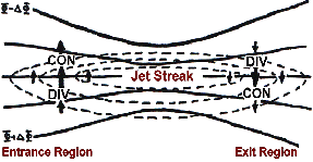
near a favorable quadrant of a maximum in the upper level jetstream
JetStream
JetStream and Mobile JetStream are two former brand names used by Telecom New Zealand to market its retail and resale ADSL-based fixed line and CDMA2000-based 3G wireless Internet access offerings respectively...
known as a jet streak, usually being the right rear and left front quadrants, where divergence
Divergence
In vector calculus, divergence is a vector operator that measures the magnitude of a vector field's source or sink at a given point, in terms of a signed scalar. More technically, the divergence represents the volume density of the outward flux of a vector field from an infinitesimal volume around...
ensues. This causes air to rush out from the top of the air column which in turn forces convergence
Convergence zone
Convergence zone usually refers to a region in the atmosphere where two prevailing flows meet and interact, usually resulting in distinctive weather conditions....
in the low-level wind field and increased upward motion within the column. The increased upward motion causes surface pressures to lower as the upward air motion counteracts gravity, lessening the weight of the atmosphere (surface pressure
Atmospheric pressure
Atmospheric pressure is the force per unit area exerted into a surface by the weight of air above that surface in the atmosphere of Earth . In most circumstances atmospheric pressure is closely approximated by the hydrostatic pressure caused by the weight of air above the measurement point...
) in that location, and thus strengthening the cyclone
Cyclone
In meteorology, a cyclone is an area of closed, circular fluid motion rotating in the same direction as the Earth. This is usually characterized by inward spiraling winds that rotate anticlockwise in the Northern Hemisphere and clockwise in the Southern Hemisphere of the Earth. Most large-scale...
. As the cyclone strengthens, the cold front sweeps towards the equator
Equator
An equator is the intersection of a sphere's surface with the plane perpendicular to the sphere's axis of rotation and containing the sphere's center of mass....
and moves around the back of the cyclone. Meanwhile, its associated warm front
Warm front
A warm front is a density discontinuity located at the leading edge of a homogeneous warm air mass, and is typically located on the equator-facing edge of an isotherm gradient...
progresses more slowly, as the cooler air ahead of the system is denser
Density
The mass density or density of a material is defined as its mass per unit volume. The symbol most often used for density is ρ . In some cases , density is also defined as its weight per unit volume; although, this quantity is more properly called specific weight...
, and therefore more difficult to dislodge. Later, the cyclones occlude
Occluded front
An occluded front is formed during the process of cyclogenesis when a cold front overtakes a warm front. When this occurs, the warm air is separated from the cyclone center at the Earth's surface...
as the poleward portion of the cold front overtakes a section of the warm front, forcing a tongue, or trowal, of warm air aloft. Eventually, the cyclone will become barotropically cold and begin to weaken.
A rapidly falling atmospheric pressure
Atmospheric pressure
Atmospheric pressure is the force per unit area exerted into a surface by the weight of air above that surface in the atmosphere of Earth . In most circumstances atmospheric pressure is closely approximated by the hydrostatic pressure caused by the weight of air above the measurement point...
is possible due to strong upper level forces on the system, and when pressures fall more than 1 millibar (0.029 inHg) per hour, such a cyclone is sometimes referred to as a bomb. These bombs rapidly drop in pressure to below 980 millibars
Bar (unit)
The bar is a unit of pressure equal to 100 kilopascals, and roughly equal to the atmospheric pressure on Earth at sea level. Other units derived from the bar are the megabar , kilobar , decibar , centibar , and millibar...
(28.94 inHg
Inch of mercury
Inches of mercury, ' is a unit of measurement for pressure. It is still widely used for barometric pressure in weather reports, refrigeration and aviation in the United States, but is seldom used elsewhere....
) under favorable conditions such as near a natural temperature gradient like the Gulf Stream
Gulf Stream
The Gulf Stream, together with its northern extension towards Europe, the North Atlantic Drift, is a powerful, warm, and swift Atlantic ocean current that originates at the tip of Florida, and follows the eastern coastlines of the United States and Newfoundland before crossing the Atlantic Ocean...
, or at a preferred quadrant of an upper level jet streak, where upper level divergence is best. The stronger the upper level divergence over the cyclone, the deeper the cyclone can become. Hurricane-force extratropical cyclones are most likely to form in the northern Atlantic and northern Pacific oceans in the months of December and January. On 14 and 15 December 1986, an extratropical cyclone near Iceland deepened to below 920 hectopascals (27.2 inHg), which is a pressure equivalent to a category 5 hurricane
Saffir-Simpson Hurricane Scale
The Saffir–Simpson Hurricane Scale , or the Saffir–Simpson Hurricane Wind Scale , classifies hurricanes — Western Hemisphere tropical cyclones that exceed the intensities of tropical depressions and tropical storms — into five categories distinguished by the intensities of their sustained winds...
. In the Arctic
Arctic Ocean
The Arctic Ocean, located in the Northern Hemisphere and mostly in the Arctic north polar region, is the smallest and shallowest of the world's five major oceanic divisions...
, the average pressure for cyclones is 988 millibars (29.18 inHg) during the winter, and 1,000 millibars (29.53 inHg) during the summer.
Extratropical transition

Tropical cyclone
A tropical cyclone is a storm system characterized by a large low-pressure center and numerous thunderstorms that produce strong winds and heavy rain. Tropical cyclones strengthen when water evaporated from the ocean is released as the saturated air rises, resulting in condensation of water vapor...
s often transform into extratropical cyclones at the end of their tropical existence, usually between 30° and 40° latitude, where there is sufficient forcing from upper-level troughs or shortwaves
Shortwave (meteorology)
A shortwave or shortwave trough is an embedded kink in the trough / ridge pattern. This is the opposite of longwaves, which are responsible for synoptic scale systems, although shortwaves may be contained within or found ahead of longwaves and range from the mesocale to the synoptic scale...
riding the Westerlies
Westerlies
The Westerlies, anti-trades, or Prevailing Westerlies, are the prevailing winds in the middle latitudes between 30 and 60 degrees latitude, blowing from the high pressure area in the horse latitudes towards the poles. These prevailing winds blow from the west to the east, and steer extratropical...
for the process of extratropical transition to begin. During extratropical transition, the cyclone begins to tilt back into the colder airmass with height, and the cyclone's primary energy source converts from the release of latent heat from condensation (from thunderstorms near the center) to baroclinic
Baroclinity
In fluid dynamics, the baroclinity of a stratified fluid is a measure of how misaligned the gradient of pressure is from the gradient of density in a fluid...
processes. The low pressure system eventually loses its warm core and becomes a cold-core system
Cold-core low
A cold-core low, also known as a cold low or cold-core cyclone, is a cyclone aloft which has an associated cold pool of air residing at high altitude within the Earth's troposphere. It is a low pressure system which strengthens with height in accordance with the thermal wind relationship. These...
. During this process, a cyclone in extratropical transition (known across the eastern North Pacific and North Atlantic oceans as the post-tropical stage) will invariably form or connect with nearby fronts and/or troughs consistent with a baroclinic system. Due to this, the size of the system will usually appear to increase, while the core weakens. However, after transition is complete, the storm may re-strengthen due to baroclinic energy, depending on the environmental conditions surrounding the system. The cyclone will also distort in shape, becoming less symmetric with time.
On rare occasions, an extratropical cyclone can transit into a tropical cyclone if it reaches an area of ocean with warmer waters and an environment with less vertical wind shear. The peak time of subtropical
Subtropical cyclone
A subtropical cyclone is a weather system that has some characteristics of a tropical and an extratropical cyclone. As early as the 1950s, meteorologists were unclear whether they should be characterized as tropical or extratropical cyclones. They were officially recognized by the National...
cyclogenesis (the midpoint of this transition) is in the months of September and October, when the difference between the temperature of the air aloft and the sea surface temperature
Sea surface temperature
Sea surface temperature is the water temperature close to the oceans surface. The exact meaning of surface varies according to the measurement method used, but it is between and below the sea surface. Air masses in the Earth's atmosphere are highly modified by sea surface temperatures within a...
is the greatest, leading to the greatest potential for instability. An example of this happening is in the 1991 Halloween Nor'easter
1991 Halloween Nor'easter
The 1991 Perfect Storm, also known as the Halloween Nor'easter of 1991, was a nor'easter that absorbed Hurricane Grace and ultimately evolved into a small hurricane late in its life cycle. The initial area of low pressure developed off Atlantic Canada on October 28. Forced southward by a ridge...
. The process known as "tropical transition" involves the usually slow development of an extratropically cold core vortex into a tropical cyclone.
Surface pressure/wind distribution
Cold front
A cold front is defined as the leading edge of a cooler mass of air, replacing a warmer mass of air.-Development of cold front:The cooler and denser air wedges under the less-dense warmer air, lifting it...
s, where the pressure gradient force
Pressure gradient force
The pressure gradient force is not actually a 'force' but the acceleration of air due to pressure difference . It is usually responsible for accelerating a parcel of air from a high atmospheric pressure region to a low pressure region, resulting in wind...
is highest. The area north and west of the cold and warm fronts connected to extratropical cyclones is known as the cold sector, while the area south and east of its associated cold and warm fronts is known as the warm sector.
The wind flow around a large cyclone is counterclockwise in the northern hemisphere, and clockwise in th[e southern hemisphere, due to the Coriolis effect
Coriolis effect
In physics, the Coriolis effect is a deflection of moving objects when they are viewed in a rotating reference frame. In a reference frame with clockwise rotation, the deflection is to the left of the motion of the object; in one with counter-clockwise rotation, the deflection is to the right...
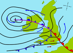
(this manner of rotation is generally referred to as cyclonic). Near this center, the pressure gradient force (from the pressure at the center of the cyclone compared to the pressure outside the cyclone) and the Coriolis force must be in an approximate balance for the cyclone to avoid collapsing in on itself as a result of the difference in pressure. The central pressure of the cyclone will lower with increasing maturity, while outside of the cyclone, the sea-level pressure is not very low; its typical value is around 1,013 millibars (29.92 inHg), which is the average sea level pressure for Earth. In most extratropical cyclones, the part of the cold front ahead of the cyclone will develop into a warm front, giving the frontal zone (as drawn on surface weather maps
Surface weather analysis
Surface weather analysis is a special type of weather map that provides a view of weather elements over a geographical area at a specified time based on information from ground-based weather stations...
) a wave-like shape. Due to their appearance on satellite images, extratropical cyclones can also be referred to as frontal waves early in their life cycle. In the United States
United States
The United States of America is a federal constitutional republic comprising fifty states and a federal district...
, an old name for such a system is "warm wave".
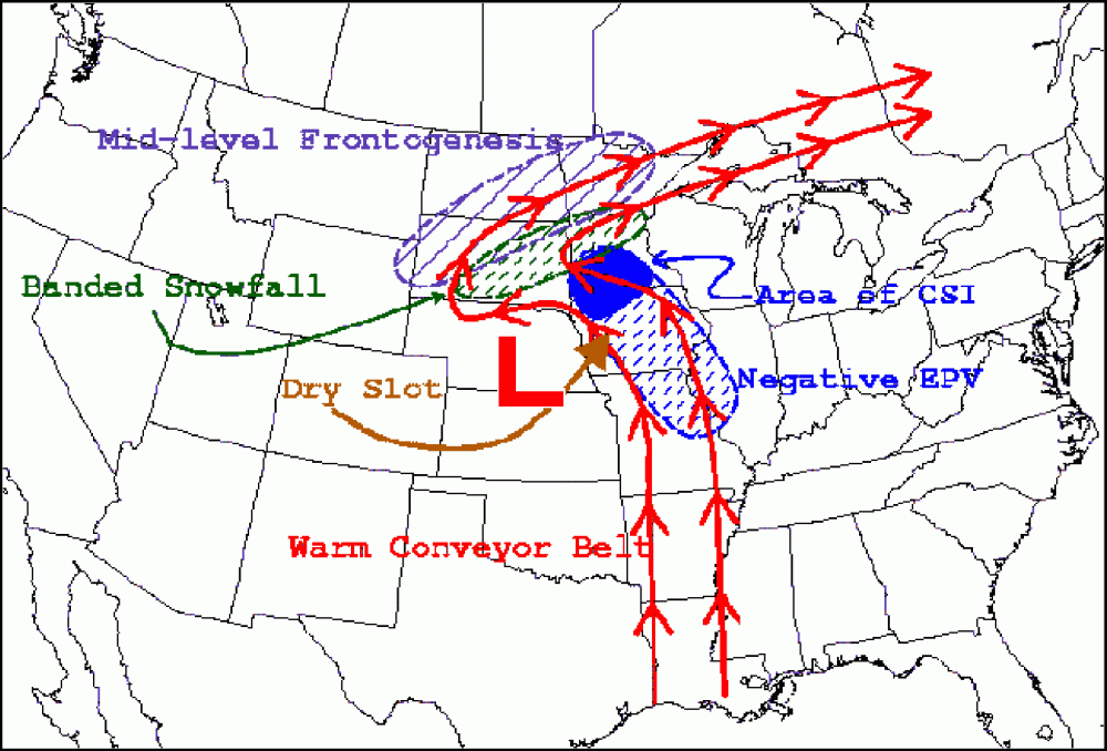
Once a cyclone occludes, a trough of warm air aloft, or "trowal" for short, will be caused by strong southerly winds on its eastern periphery rotating aloft around its northeast, and ultimately northwestern, periphery (also known as the warm conveyor belt), forcing a surface trough to continue into the cold sector on a similar curve to the occluded front. The trowal creates the portion of an occluded cyclone known as its comma head, due to the comma
Comma (punctuation)
The comma is a punctuation mark. It has the same shape as an apostrophe or single closing quotation mark in many typefaces, but it differs from them in being placed on the baseline of the text. Some typefaces render it as a small line, slightly curved or straight but inclined from the vertical, or...
-like shape of the mid-tropospheric cloudiness that accompanies the feature. It can also be the focus of locally heavy precipitation, with thunderstorms possible if the atmosphere along the trowal is unstable enough for convection.
Vertical structure
Extratropical cyclones slant back into colder air masses and strengthen with height, sometimes exceeding 30,000 feet (approximately 9 km) in depth.Above the surface of the earth, the air temperature near the center of the cyclone is increasingly colder than the surrounding environment. These characteristics are the direct opposite of those found in their tropical cyclone
Tropical cyclone
A tropical cyclone is a storm system characterized by a large low-pressure center and numerous thunderstorms that produce strong winds and heavy rain. Tropical cyclones strengthen when water evaporated from the ocean is released as the saturated air rises, resulting in condensation of water vapor...
s; thus, they are sometimes called "cold-core lows". Various charts can be examined to check the characteristics of a cold-core system with height, such as the 700 millibars (20.67 inHg) chart, which is at about 10,000 feet or 3,000 meters in height. Cyclone phase diagrams are used to tell whether a cyclone is tropical, subtropical, or extratropical.
Cyclone evolution
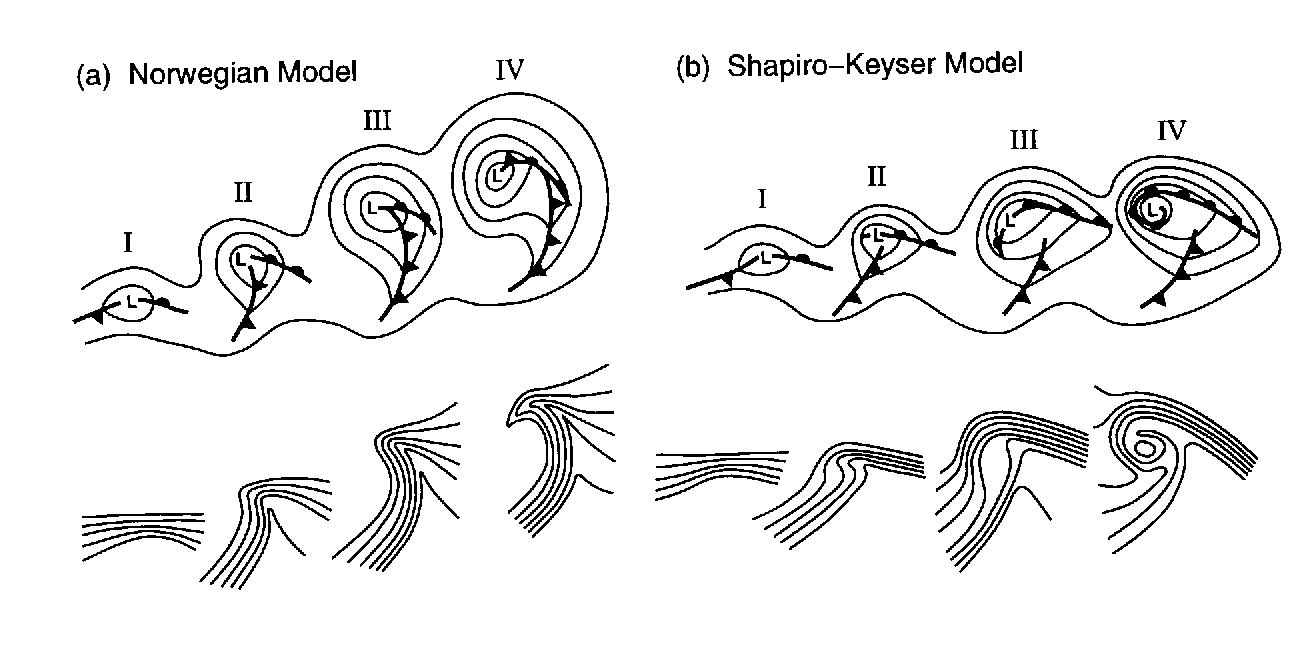
Norwegian cyclone model
Of the two theories on extratropical cyclone structure and life cycle, the older is the Norwegian Cyclone Model, developed during World War IWorld War I
World War I , which was predominantly called the World War or the Great War from its occurrence until 1939, and the First World War or World War I thereafter, was a major war centred in Europe that began on 28 July 1914 and lasted until 11 November 1918...
. In this theory, cyclones develop as they move up and along a frontal boundary, eventually occluding
Occluded front
An occluded front is formed during the process of cyclogenesis when a cold front overtakes a warm front. When this occurs, the warm air is separated from the cyclone center at the Earth's surface...
and reaching a barotropically cold environment. It was developed completely from surface-based weather observations, including descriptions of clouds found near frontal boundaries. This theory still retains merit, as it is a good description for extratropical cyclones over continental landmasses.
Shapiro-Keyser model
A second competing theory for extratropical cyclone development over the oceans is the Shapiro-Keyser model, developed in 1990. Its main differences with the Norwegian Cyclone Model are the fracture of the cold front, treating warm-type occlusions and warm fronts as the same, and allowing the cold front to progress through the warm sector perpendicularPerpendicular
In geometry, two lines or planes are considered perpendicular to each other if they form congruent adjacent angles . The term may be used as a noun or adjective...
to the warm front. This model was based on oceanic cyclones and their frontal structure, as seen in surface observations and in previous projects which used aircraft to determine the vertical structure of fronts across the northwest Atlantic.
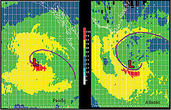
Warm seclusion
A warm seclusion is the mature phase of the extratropical cyclone lifecycle. This was conceptualized after the ERICAERICA (Meteorology)
ERICA, or the Experiment on Rapidly Intensifying Cyclones over the Atlantic, is a scientific field project that started in the winter of 1988/1989. Its aims were to better understand the processes involved in rapid cyclogenesis, and so improve understanding and forecasting of the situations that...
field experiment of the late 1980s, which produced observations of intense marine cyclones that indicated an anomalously warm low-level thermal structure, secluded (or surrounded) by a bent-back warm front and a coincident chevron-shaped band of intense surface winds. The Norwegian Cyclone Model, as developed by the Bergen School of Meteorology, largely observed cyclones at the tail end of their lifecycle and used the term occlusion to identify the decaying stages.
Warm seclusions may have cloud-free, eye
Eye (cyclone)
The eye is a region of mostly calm weather found at the center of strong tropical cyclones. The eye of a storm is a roughly circular area and typically 30–65 km in diameter. It is surrounded by the eyewall, a ring of towering thunderstorms where the second most severe weather of a cyclone...
-like features at their center (reminiscent of tropical cyclone
Tropical cyclone
A tropical cyclone is a storm system characterized by a large low-pressure center and numerous thunderstorms that produce strong winds and heavy rain. Tropical cyclones strengthen when water evaporated from the ocean is released as the saturated air rises, resulting in condensation of water vapor...
s), significant pressure falls, hurricane force winds, and moderate to strong convection
Convection
Convection is the movement of molecules within fluids and rheids. It cannot take place in solids, since neither bulk current flows nor significant diffusion can take place in solids....
. The most intense warm seclusions often attain pressures less than 950 millibars (28.05 inHg) with a definitive lower to mid-level warm core structure. A warm seclusion, the result of a baroclinic lifecycle, occurs at latitudes well poleward of the tropics.
As latent heat flux
Flux
In the various subfields of physics, there exist two common usages of the term flux, both with rigorous mathematical frameworks.* In the study of transport phenomena , flux is defined as flow per unit area, where flow is the movement of some quantity per time...
releases are important for their development and intensification, most warm seclusion events occur over the ocean
Ocean
An ocean is a major body of saline water, and a principal component of the hydrosphere. Approximately 71% of the Earth's surface is covered by ocean, a continuous body of water that is customarily divided into several principal oceans and smaller seas.More than half of this area is over 3,000...
s; they may impact coastal nations with hurricane force wind
Wind
Wind is the flow of gases on a large scale. On Earth, wind consists of the bulk movement of air. In outer space, solar wind is the movement of gases or charged particles from the sun through space, while planetary wind is the outgassing of light chemical elements from a planet's atmosphere into space...
s and torrential rain
Rain
Rain is liquid precipitation, as opposed to non-liquid kinds of precipitation such as snow, hail and sleet. Rain requires the presence of a thick layer of the atmosphere to have temperatures above the melting point of water near and above the Earth's surface...
. Climatologically, the Northern Hemisphere sees warm seclusions during the cold season months, while the Southern Hemisphere may see a strong cyclone event such as this during all times of the year.
In all tropical basins, except the Northern Indian Ocean, the extratropical transition of a tropical cyclone may result in reintensification into a warm seclusion. For example, Hurricane Maria
Hurricane Maria (2005)
Hurricane Maria was a Cape Verde-type hurricane which formed in September during the 2005 Atlantic hurricane season. Maria was the thirteenth named storm, sixth hurricane, and fourth major hurricane of the record-breaking season....
of 2005 reintensified into a strong baroclinic system and achieved warm seclusion status at maturity (or lowest pressure).
Motion
Zonal flow
Zonal flow is a meteorological term meaning that the general flow pattern is west to east, or east to west, along the Earth's latitude lines . Extratropical cyclones in this environment tend to be weaker, moving faster and producing relatively little impact on local weather.-References:**...
".
When the general flow pattern buckles from a zonal pattern to the meridional pattern, a slower movement in a north or southward direction is more likely. Meridional flow
Meridional flow
Meridional flow is a meteorological term meaning that the general flow pattern is north to south, or south to north, along the Earth's longitude lines . Extratropical cyclones in this environment tend to be stronger and move slower...
patterns feature strong, amplified troughs and ridges, generally with more northerly and southerly flow.
Changes in direction of this nature are most commonly observed as a result of a cyclone's interaction with other low pressure systems, troughs
Trough (meteorology)
A trough is an elongated region of relatively low atmospheric pressure, often associated with fronts.Unlike fronts, there is not a universal symbol for a trough on a weather chart. The weather charts in some countries or regions mark troughs by a line. In the United States, a trough may be marked...
, ridges
Ridge (meteorology)
A ridge is an elongated region of relatively high atmospheric pressure, the opposite of a trough....
, or with anticyclone
Anticyclone
An anticyclone is a weather phenomenon defined by the United States' National Weather Service's glossary as "[a] large-scale circulation of winds around a central region of high atmospheric pressure, clockwise in the Northern Hemisphere, counterclockwise in the Southern Hemisphere"...
s. A strong and stationary anticyclone can effectively block the path of an extratropical cyclone. Such blocking patterns are quite normal, and will generally result in a weakening of the cyclone, the weakening of the anticyclone, a diversion of the cyclone towards the anticyclones periphery, or a combination of all three to some extent depending on the precise conditions. It is also common for an extratropical cyclone to strengthen as the blocking anticyclone or ridge weakens in these circumstances.
Where an extratropical cyclone encounters another extratropical cyclone (or almost any other kind of cyclonic vortex
Vortex
A vortex is a spinning, often turbulent,flow of fluid. Any spiral motion with closed streamlines is vortex flow. The motion of the fluid swirling rapidly around a center is called a vortex...
in the atmosphere), the two may combine to become a binary cyclone, where the vortices of the two cyclones rotate around each other (known as the "Fujiwhara effect
Fujiwhara effect
The Fujiwhara effect or Fujiwara interaction, named after Sakuhei Fujiwhara, is a type of interaction between two nearby cyclonic vortices, causing them to appear to "orbit" each other.-Description:...
"). This most often results in a merging of the two low pressure systems into a single extratropical cyclone, or can less commonly result in a mere change of direction of either one or both of the cyclones. The precise results of such interactions depend on factors such as the size of the two cyclones, their strength, their distance from each other, and the prevailing atmospheric conditions around them.
General
Wind
Wind is the flow of gases on a large scale. On Earth, wind consists of the bulk movement of air. In outer space, solar wind is the movement of gases or charged particles from the sun through space, while planetary wind is the outgassing of light chemical elements from a planet's atmosphere into space...
s of 15–30 km/h (10–20 mph), or they can be cold and dangerous with torrential rain and winds exceeding 119 km/h (74 mph), (sometimes referred to as windstorms
European windstorm
A European windstorm is a severe cyclonic windstorm associated with areas of low atmospheric pressure that track across the North Atlantic towards northwestern Europe. They are most common in the winter months...
in Europe). The band of precipitation
Precipitation (meteorology)
In meteorology, precipitation In meteorology, precipitation In meteorology, precipitation (also known as one of the classes of hydrometeors, which are atmospheric water phenomena is any product of the condensation of atmospheric water vapor that falls under gravity. The main forms of precipitation...
that is associated with the warm front
Warm front
A warm front is a density discontinuity located at the leading edge of a homogeneous warm air mass, and is typically located on the equator-facing edge of an isotherm gradient...
is often extensive. In mature extratropical cyclones, an area known as the comma head on the northwest periphery of the surface low can be a region of heavy precipitation, frequent thunderstorm
Thunderstorm
A thunderstorm, also known as an electrical storm, a lightning storm, thundershower or simply a storm is a form of weather characterized by the presence of lightning and its acoustic effect on the Earth's atmosphere known as thunder. The meteorologically assigned cloud type associated with the...
s, and thundersnow
Thundersnow
Thundersnow, also known as a winter thunderstorm or a thunder snowstorm, is a relatively rare kind of thunderstorm with snow falling as the primary precipitation instead of rain. It typically falls in regions of strong upward motion within the cold sector of an extratropical cyclone...
s. Cyclones tend to move along a predictable path at a moderate rate of progress. During fall
Autumn
Autumn is one of the four temperate seasons. Autumn marks the transition from summer into winter usually in September or March when the arrival of night becomes noticeably earlier....
, winter, and spring, the atmosphere over continents can be cold enough through the depth of the troposphere
Troposphere
The troposphere is the lowest portion of Earth's atmosphere. It contains approximately 80% of the atmosphere's mass and 99% of its water vapor and aerosols....
to cause snowfall.
Severe weather
Squall lines, or solid bands of strong thunderstorms, can form ahead of cold fronts and lee troughs due to the presence of significant atmospheric moisture and strong upper level divergence, leading to hailHail
Hail is a form of solid precipitation. It consists of balls or irregular lumps of ice, each of which is referred to as a hail stone. Hail stones on Earth consist mostly of water ice and measure between and in diameter, with the larger stones coming from severe thunderstorms...
and high winds. When significant directional wind shear exists in the atmosphere ahead of a cold front in the presence of a strong upper level jet stream, tornado formation is possible. Although tornadoes can form anywhere on Earth, the greatest number occur in the Great Plains
Great Plains
The Great Plains are a broad expanse of flat land, much of it covered in prairie, steppe and grassland, which lies west of the Mississippi River and east of the Rocky Mountains in the United States and Canada. This area covers parts of the U.S...
in the United States, because downsloped winds off the north-south oriented Rocky Mountains
Rocky Mountains
The Rocky Mountains are a major mountain range in western North America. The Rocky Mountains stretch more than from the northernmost part of British Columbia, in western Canada, to New Mexico, in the southwestern United States...
, which can form a dryline, aid their development at any strength
Fujita scale
The Fujita scale , or Fujita-Pearson scale, is a scale for rating tornado intensity, based primarily on the damage tornadoes inflict on human-built structures and vegetation...
.
Explosive development of extratropical cyclones can be sudden. The storm known in the UK as the "Great Storm of 1987
Great Storm of 1987
The Great Storm of 1987 occurred on the night of 15/16 October 1987, when an unusually strong weather system caused winds to hit much of southern England and northern France...
" deepened to 953 millibars (28.14 inHg) with a highest recorded wind of 220 km/h (137 mph), resulting in the loss of 19 lives, 15 million trees, widespread damage to homes and an estimated economic cost of £
Pound sterling
The pound sterling , commonly called the pound, is the official currency of the United Kingdom, its Crown Dependencies and the British Overseas Territories of South Georgia and the South Sandwich Islands, British Antarctic Territory and Tristan da Cunha. It is subdivided into 100 pence...
1.2 billion (US$
United States dollar
The United States dollar , also referred to as the American dollar, is the official currency of the United States of America. It is divided into 100 smaller units called cents or pennies....
2.3 billion).
Although most tropical cyclones that become extratropical quickly dissipate or are absorbed by another weather system, they can still retain winds of hurricane or gale force. In 1954, Hurricane Hazel
Hurricane Hazel
Hurricane Hazel was the deadliest and costliest hurricane of the 1954 Atlantic hurricane season. The storm killed as many as 1,000 people in Haiti before striking the United States near the border between North and South Carolina, as a Category 4 hurricane...
became extratropical over North Carolina
North Carolina
North Carolina is a state located in the southeastern United States. The state borders South Carolina and Georgia to the south, Tennessee to the west and Virginia to the north. North Carolina contains 100 counties. Its capital is Raleigh, and its largest city is Charlotte...
as a strong Category 3 storm. The Columbus Day Storm of 1962
Columbus Day Storm of 1962
The Columbus Day Storm of 1962 was an extratropical cyclone that ranked among the most intense to strike the United States Pacific Northwest since at least 1948, likely since the January 9, 1880 "Great Gale" and snowstorm...
, which evolved from the remains of Typhoon Freda, caused heavy damage in Oregon
Oregon
Oregon is a state in the Pacific Northwest region of the United States. It is located on the Pacific coast, with Washington to the north, California to the south, Nevada on the southeast and Idaho to the east. The Columbia and Snake rivers delineate much of Oregon's northern and eastern...
and Washington, with widespread damage equivalent to at least a Category 3. In 2005, Hurricane Wilma
Hurricane Wilma
Hurricane Wilma was the most intense tropical cyclone ever recorded in the Atlantic basin. Wilma was the twenty-second storm , thirteenth hurricane, sixth major hurricane, and fourth Category 5 hurricane of the record-breaking 2005 season...
began to lose tropical characteristics while still sporting Category 3-force winds (and became fully extratropical as a Category 1 storm).
Climate and general circulation
In the classic analysis by Edward Lorenz (the Lorenz Energy Cycle), extratropical cyclones (so called atmospheric transients) acts as a mechanism in converting potential energy that is created by pole to equator temperature gradients to eddy kinetic energy. In the process, the pole-equator temperature gradient is reduced (i.e. energy is transported poleward to warm up the higher latitudes).The existence of such transients are also closely related to the formation of the Icelandic and Aleutian Low - the two most prominent general circulation features in the mid- to sub-polar northern latitudes. The two lows are formed by both the transport of kinetic energy and the latent heating (the energy released when water phase changed from vapor to liquid during precipitation) from the extratropical cyclones.
Historic storms
A violent storm during the Crimean WarCrimean War
The Crimean War was a conflict fought between the Russian Empire and an alliance of the French Empire, the British Empire, the Ottoman Empire, and the Kingdom of Sardinia. The war was part of a long-running contest between the major European powers for influence over territories of the declining...
on November 14, 1854 wrecked 30 vessels, and sparked initial investigations into meteorology and forecasting in Europe. In the United States, the Columbus Day Storm of 1962
Columbus Day Storm of 1962
The Columbus Day Storm of 1962 was an extratropical cyclone that ranked among the most intense to strike the United States Pacific Northwest since at least 1948, likely since the January 9, 1880 "Great Gale" and snowstorm...
led to Oregon
Oregon
Oregon is a state in the Pacific Northwest region of the United States. It is located on the Pacific coast, with Washington to the north, California to the south, Nevada on the southeast and Idaho to the east. The Columbia and Snake rivers delineate much of Oregon's northern and eastern...
's lowest measured pressure of 965.5 hPa
Pascal (unit)
The pascal is the SI derived unit of pressure, internal pressure, stress, Young's modulus and tensile strength, named after the French mathematician, physicist, inventor, writer, and philosopher Blaise Pascal. It is a measure of force per unit area, defined as one newton per square metre...
(28.51 inHg), violent winds, and US$170 million in damage (1964 dollars). A rapidly strengthening storm struck Vancouver Island
Vancouver Island
Vancouver Island is a large island in British Columbia, Canada. It is one of several North American locations named after George Vancouver, the British Royal Navy officer who explored the Pacific Northwest coast of North America between 1791 and 1794...
on October 11, 1984, and inspired the development of moored buoys off the western coast of Canada
Canada
Canada is a North American country consisting of ten provinces and three territories. Located in the northern part of the continent, it extends from the Atlantic Ocean in the east to the Pacific Ocean in the west, and northward into the Arctic Ocean...
. The Wahine disaster
Wahine disaster
The Wahine disaster occurred on 10 April 1968 when the TEV Wahine, a New Zealand inter-island ferry of the Union Company, foundered on Barrett Reef at the entrance to Wellington Harbour and capsized near Steeple Rock...
, New Zealand's most infamous maritime disaster, that caused the death of 53 people occurred during a major extratropical storm. The Braer Storm of January 1993
Braer Storm of January 1993
The Braer Storm of January 1993 is the most intense extratropical cyclone on record for the northern Atlantic ocean. Developing as a weak frontal wave on January 8, 1993, the system moved rapidly northeast developing at a moderate pace...
was the strongest extratropical cyclone known to occur across the northern Atlantic ocean, with a central pressure of 914 mb.
In the Southern Hemisphere
Southern Hemisphere
The Southern Hemisphere is the part of Earth that lies south of the equator. The word hemisphere literally means 'half ball' or "half sphere"...
, a violent extratropical storm hit Uruguay
Uruguay
Uruguay ,officially the Oriental Republic of Uruguay,sometimes the Eastern Republic of Uruguay; ) is a country in the southeastern part of South America. It is home to some 3.5 million people, of whom 1.8 million live in the capital Montevideo and its metropolitan area...
on August 23–24, 2005, killing 10 people. The system exceeded 100 mph (160 km/h) winds and Montevideo
Montevideo
Montevideo is the largest city, the capital, and the chief port of Uruguay. The settlement was established in 1726 by Bruno Mauricio de Zabala, as a strategic move amidst a Spanish-Portuguese dispute over the platine region, and as a counter to the Portuguese colony at Colonia del Sacramento...
, the 1.5 million inhabitants capital of the county was affected by tropical storm-force winds for over 12 hours and by hurricane-force winds for nearly four hours. Peak gusts were registered at Carrasco International Airport 107 mph (172.2 km/h) and at the Harbour of Montevideo 116 mph (186.7 km/h). The lowest reported pressure was 991.7 hPa. Extratropical cyclones are common in this part of the globe during fall, winter and spring months. The winds usually peak to 80–110 km/h, but winds of 116 mph are very uncommon.
See also
- 1991 Perfect Storm
- Columbus Day Storm
- Cyclogenesis
- European windstormEuropean windstormA European windstorm is a severe cyclonic windstorm associated with areas of low atmospheric pressure that track across the North Atlantic towards northwestern Europe. They are most common in the winter months...
- Extratropical transition techniqueExtratropical transition techniqueThe extratropical transition technique is a system used to subjectively estimate the intensity of tropical cyclones undergoing transition into extratropical cyclones based on visible and infrared satellite imagery...
- Nor'easterNor'easterA nor'easter is a type of macro-scale storm along the East Coast of the United States and Atlantic Canada, so named because the storm travels to the northeast from the south and the winds come from the northeast, especially in the coastal areas of the Northeastern United States and Atlantic Canada...
- Storm of the Century (1993)
- Subtropical cycloneSubtropical cycloneA subtropical cyclone is a weather system that has some characteristics of a tropical and an extratropical cyclone. As early as the 1950s, meteorologists were unclear whether they should be characterized as tropical or extratropical cyclones. They were officially recognized by the National...
- Surface weather analysisSurface weather analysisSurface weather analysis is a special type of weather map that provides a view of weather elements over a geographical area at a specified time based on information from ground-based weather stations...
- ThunderstormThunderstormA thunderstorm, also known as an electrical storm, a lightning storm, thundershower or simply a storm is a form of weather characterized by the presence of lightning and its acoustic effect on the Earth's atmosphere known as thunder. The meteorologically assigned cloud type associated with the...
- ThundersnowThundersnowThundersnow, also known as a winter thunderstorm or a thunder snowstorm, is a relatively rare kind of thunderstorm with snow falling as the primary precipitation instead of rain. It typically falls in regions of strong upward motion within the cold sector of an extratropical cyclone...
- Tropical cyclogenesisTropical cyclogenesisTropical cyclogenesis is the term that describes the development and strengthening of a tropical cyclone in the atmosphere. The mechanisms through which tropical cyclogenesis occurs are distinctly different from those through which mid-latitude cyclogenesis occurs...
- Tropical cycloneTropical cycloneA tropical cyclone is a storm system characterized by a large low-pressure center and numerous thunderstorms that produce strong winds and heavy rain. Tropical cyclones strengthen when water evaporated from the ocean is released as the saturated air rises, resulting in condensation of water vapor...
- Carmen (storm)Carmen (storm)Carmen was an extremely powerful extratropical cyclone and European windstorm which caused widespread damage in the American state of Maine, then crossed the Atlantic Ocean and affected the United Kingdom, Ireland, France, Belgium and the Netherlands....
- Hurricane Florence (2006)Hurricane Florence (2006)Hurricane Florence was the first Atlantic hurricane to produce hurricane force winds on Bermuda since Hurricane Fabian hit the island in September 2003. The seventh tropical storm and second hurricane of the 2006 Atlantic hurricane season, Florence developed from a tropical wave in the tropical...