
Interstate 90
Encyclopedia
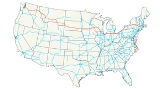
Interstate 90 is the longest Interstate Highway in the United States at 3099.07 miles (4,987.5 km). It is the northernmost coast-to-coast interstate, and parallels US 20
for the most part. Its western terminus is in Seattle
, at Edgar Martinez Drive S. near Safeco Field
and CenturyLink Field, and its eastern terminus is in Boston, at Route 1A
near Logan International Airport
. Interstate 90 also goes through Spokane
and crosses the Continental Divide
over Homestake Pass
just east of Butte, Montana
.
East of the Wisconsin
-Illinois
border, much of I-90 is tolled, along the following toll road
s (several of which predate the Interstate system): the Jane Addams Memorial Tollway, Chicago Skyway
, Indiana Toll Road
, Ohio Turnpike
, New York State Thruway
, and the Massachusetts Turnpike
, including the Ted Williams Tunnel
. It is free through downtown Chicago; Greater Cleveland
and the rest of northeastern Ohio
; Pennsylvania
; and through brief sections near Buffalo
, Albany
, and Boston
.
|WA
|299.62
|477.85
|-
|ID
|73.55
|118.37
|-
|MT
|551.68
|887.84
|-
|WY
|208.8
|336.03
|-
|SD
|412.76
|664.27
|-
|MN
|275.7
|443.70
|-
|WI
|187.14
|301.84
|-
|IL
|123.89
|199.38
|-
|IN
|156.28
|251.51
|-
|OH
|244.75
|393.89
|-
|PA
|46.4
|74.67
|-
|NY
|385.48
|620.37
|-
|MA
|135.72
|218.42
|-
|Total
|3101.77
|4988.14
|}
neighborhood of Seattle, Washington
. I-90 eastbound begins at exit 2B, Edgar Martínez
Drive S and 4th Avenue S. I-90 westbound exit 2B ends at Edgar Martínez Dr and 4th Ave near Safeco Field
, as well as 4th Ave just north of S. Royal Broughman Way near CenturyLink Field.
The tunnel that carries Interstate 90 under the Mount Baker Ridge
is on the National Register of Historic Places
. The east portal of the tunnel (visible when entering Seattle from the east) is constructed as a bas relief concrete sculpture.
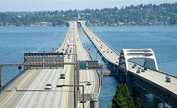
 I-90 incorporates two of the longest floating bridge
s in the world, the Lacey V. Murrow Memorial Bridge
and the Homer M. Hadley Memorial Bridge
, which cross Lake Washington
from Seattle
to Mercer Island, Washington
. They are the second and fifth longest such bridges, respectively.
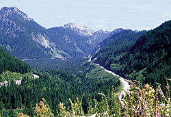
Forty miles east of Bellevue I-90 traverses the Cascade Range
's Snoqualmie Pass
, elevation 3022 feet (921.1 m). At mile post 137, it crosses the Columbia River
on the Vantage Bridge
, and after entering Spokane, Washington
near mile post 279, enters Idaho 20 miles (32.2 km) later.
Since 1980, I-90 from Seattle to Thorp, Washington
, was designated the Mountains to Sound Greenway
to protect its outstanding scenic and cultural resources.
Washington Law Defining Route
The Washington section of I-90 is defined in the Revised Code of Washington (RCW 47.17.140).
still prides itself on having what was the last stop light on I-90. Its downtown has many historical buildings, which would have been wiped out by the original planned route of the freeway, so in 1976, city leaders had the downtown placed on the National Register of Historic Places
. As a result, the federal government was forced, at great expense, to reroute the freeway to the northern edge of downtown and elevate it. That section of I-90 opened in September 1991. A bicycle path is routed beneath part of that segment.
on I-90 in Montana
. The speed limit was simply defined as "reasonable and prudent" as determined on a case by case basis by the Montana Highway Patrol
. The speed limit in Montana is now 75 mph (120 km/h). From the west I-90 enters Montana on the summit of Lookout Pass. It passes next to Missoula
and runs through Butte
before crossing the continental divide just east of Butte where it goes over Homestake Pass. It passes between the Gallatin and Bridger mountain ranges over Bozeman Pass
between Bozeman
and Livingston
. It follows the Yellowstone River from Livingston to Billings
where it connects the suburbs of Laurel
and Lockwood
with the rest of the Billings. In Lockwood it intersects with I-94's western terminus and turns south. South of Hardin
it passes the site of the Battle of the Little Bighorn
(Custer's Last Stand) at Crow Agency
on the Crow Indian Reservation
. Montana boasts the longest stretch of I-90, ranging just over 551 miles (886.7 km).
(if traveling eastward from the north), it diverges from I-25 with a more east–west orientation.
, South Dakota
at the Wyoming border I-90 is a four lane divided highway with a grass median. In the Sioux Falls
area, I-90 intersects I-29 and continues east a short distance to Minnesota
. I-90 is the longest east–west thoroughfare in South Dakota. This interstate goes through Mitchell
, Sioux Falls, and Rapid City. It does not go through the state capital of Pierre
.
The South Dakota section of I-90 is defined at South Dakota Codified Laws § 31-4-184.
I-90 crosses southern Minnesota from the South Dakota border near Beaver Creek, Minnesota
, to the Mississippi River
near La Crosse, Wisconsin
. On most of its length in the state, it is close to the Iowa
border and fairly parallel with it. In southeast Minnesota
, it curves north to Rochester
and Winona
.
The wayside rest area near Blue Earth, Minnesota
, is where the east-building I-90 and west-building I-90 teams linked up in 1978, thus completing the final mile and joining the 3099.07 miles (4,987.5 km) of the interstate. Since being overlaid with bituminous paving in 2006, the original 4 feet (1.2 m) gold colored cement concert line marking the completion of I-90 has been replaced with gold paint on just the shoulder portions of the roadway at the same location; plaques dedicating and describing this special segment of I-90 pavement can be found at the Blue Earth rest areas.
and I-39 in Portage
. I-94 separates from I-90 at Madison
.
I-39/90/94 from just south of Portage to Madison is the longest concurrency of three Interstate Highways in the United States.
 In the state of Illinois
, Interstate 90 enters Illinois north of Rockford
oriented north–south joined with Interstate 39
. It then runs east-southeast directly to the city of Chicago
. From Rockford to Interstate 294
the road is tolled and called the Jane Addams Memorial Tollway. Prior to 2007 the Jane Addams Memorial Tollway was called the Northwest Tollway. In the Chicago metropolitan area, I-90 is known by three names from O'Hare International Airport
to the Indiana
state line. The Kennedy Expressway
runs from O'Hare to Interstate 290
and the Chicago Loop
. I-90 continues running south of the Loop on part of the Dan Ryan Expressway
, and then southeast onto the tolled Chicago Skyway
into Indiana.
. Interstate 90 enters from Illinois at the Chicago Skyway
. It then runs to the concurrency of Interstates 80
/94
east of Interstate 65
, where I-80 leaves I-94 and joins with I-90. The combined I-80/90 route runs east across northern Indiana and near the southern border of Michigan
to the Ohio state line.
As part of the Toll Road, I-80/90 passes to the north of South Bend
and Elkhart
. It also passes north of Angola
at Interstate 69
.
as it crosses the border. I-90 follows the Ohio Turnpike
until Lorain
(west of Cleveland), where it turns north to follow a route near the shores of Lake Erie
. Originally, it was going to be parallel to, and north of, I-80/Ohio Turnpike further west to Toledo. Parts were built with an interim assignment of State Route 2. Later; that plan was abandoned, and the I-90/I-80 exit/connector was built instead; those existing parts retain the Rt. 2 designation.
In Cleveland
, Interstate 90 serves as the Innerbelt
at the confluence of the northern termini of Interstates 71
and 77
. One of the most peculiar and hazardous stretches of Interstate 90 is the section of highway passing through downtown
, known locally as Dead Man's Curve
. Here, the road takes a nearly 90-degree turn. While there are plenty of large signs, flashing lights, and rumble strips alerting motorists to this turn, there have still been a large number of accidents resulting from inattentive motorists. There are plans to realign the freeway along a shallower curve within the next decade, as part of a larger project to improve the highway system in Cleveland.
The Innerbelt in Cleveland also utilizes a steel-gusset bridge of the same design as the I-35W bridge that failed in Minneapolis, Minnesota
. Since September 30, 2008, two lanes in each direction of the 8-lane bridge were closed to reduce the weight load on the structure. The bridge is currently under close inspection as it has deteriorated greatly over the last few years. On October 8, 2008, the bridge was closed entirely to undergo a stress test. In May and June 2009, the bridge was closed while engineers lifted it with hydraulic jacks and moved it approximately six inches to realign it. It is largely believed that the bridge will be replaced within the next five years by a new span. Many in the Cleveland area are beginning to question the safety of the bridge, and the Ohio Department of Transportation continues to stress that the bridge is safe and if there was any imminent danger it would be permanently closed. There are plans to build a new bridge which will carry I-90 west and I-71 south. The old bridge will carry I-71 north and I-90 east.
Construction is now underway on the new bridge trusses. The project started in late 2010 and will wrap up in about 3 to 4 years. as stated by ODOT.
, Pennsylvania, and then leaves Pennsylvania for New York. At 46.4 miles (74.67 km), it is Interstate 90's shortest intrastate length.
While not an interstate, a portion of Pennsylvania Route 5
in Erie has recently been named Pennsylvania Route 290
. The purpose is to encourage travelers to use this stretch of Erie's 12th Street as a loop, connecting Interstate 79
and 90 to the Bayfront Connector
and downtown Erie.
I-90 becomes the New York State Thruway
upon entering New York. It follows the Lake Erie
coast until Buffalo
, where it joins the old Water Level Route until Albany
. There, it takes a short detour before joining the New York State Thruway
Berkshire Connector.
Almost all of the New York
portion of the road is a toll road
, comprising the east–west portion of the New York State Thruway
mainline and part of the Berkshire Connector, operated by the New York State Thruway Authority. It was originally constructed as part of the Thruway project in the middle 1950s and received its current designation as Interstate 90 in 1958. The road roughly follows the course of the 19th-century Erie Canal
for much of its length in New York State. "I-90" (operated by NYSDOT
) carries Interstate 90 between the two; however, the Berkshire Section directly connects to the mainline (at Thruway interchange 21A) 6.5 miles (10.5 km) west of the point where I-90 joins it (at Thruway interchange B1).
The mileposts and exit number
s on the New York State Thruway
mainline originate at the New York City
line and increase northward along Interstate 87
and westward along Interstate 90. As a result, mileposts and exit number
s on the I-90 section of the Thruway
mainline increase from east to west, contrary to modern practices where numbers increase from the west or south. The NYSDOT-maintained portion in between, known to locals as "I-90," does number its mileage and exits in the traditional west-to-east method. (Ironically, the NYSDOT maintained portion of I-90 is oriented geographically north–south for most of its length, so the exit numbers seem to increase from north to south.) Exit and milepost numbering starts over again when the Berkshire Section of the Thruway begins, with exit and mile numbers preceded by the letter B (Exit B1, Exit B2, Mile B1, Mile B2, and so on).
There once were two metric
-only signs on the westbound New York State Thruway
around Syracuse
, which is about 100 miles (161 km) from Ontario
. The NYS Thruway Authority decided to test metric signage, which may have briefly included an 88 km/h speed limit sign, on the Thruway. There was also a sign displaying the distance to the Interstate 81
interchange in kilometers in Dewitt. These signs are now displayed in just miles.
I-90 is one of two Interstates having a complete set of nine spur route
s (190, 290, 390...890, 990) within one state, in New York
, with the other being Interstate 5, in California. In addition, I-990, a short spur route near Buffalo
, New York not directly connected to I-90, is the highest number given to an Interstate.
I-790 in Utica used to have a completely direct connection with I-90 at Thruway interchange 31. Various road redesign projects over the years have eventually led to this direct connection being partially severed. Traffic exiting the Thruway must use two different surface streets to reach I-790. However, it is still possible to travel from I-790 directly onto the Thruway. I-790 has some other oddities: no exit numbers, no reassurance marker
s, and it runs concurrent with New York State Route 5
for its entire length.
The New York section of I-90 west of the Berkshire Section of the New York Thruway is defined as Interstate Route 504 in New York Highway Law § 340-a.

, which opened on May 15, 1957, from West Stockbridge at the New York state border to Route 128.
The first section of the Boston Extension opened in September 1964 from the original terminus at Route 128 to the Allston/Brighton Tolls. The entire Boston Extension opened on February 18, 1965 continuing from the Allston/Brighton Tolls to I-93
in Downtown Boston. The new extension added 12 miles (19.3 km) to the MassPike's original 123.
I-90 was extended again as part of the Big Dig from its terminus at I-93 to Boston's Logan International Airport
and a terminus of Route 1A
in January 2003 via tunnels under the Fort Point Channel and the Ted Williams Tunnel
under Boston Harbor. This extended I-90 by an additional 1.3 miles (2.1 km), shifting the eastern terminus to Route 1A.
Turnpike Doubles are permitted to travel between exit 11 and through the New York state border.
, New York State Thruway
, Ohio Turnpike
, Indiana Toll Road
, Chicago Skyway
, and the Jane Addams Memorial Tollway all predate I-90 and were used for parts of its route. This also means that substantial portions of the route are not precisely to Interstate Highway standards
, but they are usually close.
The popular TV sitcom Cheers
was set in Boston, on the east end of I-90. When the spin-off Frasier
was being developed, it was decided to set that series as far from Boston as possible, so Seattle, on the west end of I-90, was chosen as the setting.

I-90 is the only interstate to have a complete set of auxiliary routes (i.e., all nine possible three-digit route numbers) within a single state, that being New York
.
U.S. Route 20
U.S. Route 20 is an east–west United States highway. As the "0" in its route number implies, US 20 is a coast-to-coast route. Spanning , it is the longest road in the United States, and the route sparsely parallels Interstate 90...
for the most part. Its western terminus is in Seattle
Seattle, Washington
Seattle is the county seat of King County, Washington. With 608,660 residents as of the 2010 Census, Seattle is the largest city in the Northwestern United States. The Seattle metropolitan area of about 3.4 million inhabitants is the 15th largest metropolitan area in the country...
, at Edgar Martinez Drive S. near Safeco Field
Safeco Field
Safeco Field is a retractable roof baseball stadium located in Seattle, Washington. The stadium, owned and operated by the Washington-King County Stadium Authority, is the home stadium of the Seattle Mariners of Major League Baseball and has a seating capacity of 47,878 for baseball...
and CenturyLink Field, and its eastern terminus is in Boston, at Route 1A
Route 1A (Massachusetts)
Route 1A is a south–north state highway in Massachusetts. It is an alternate route to U.S. 1 with three signed sections and two unsigned sections where the highway is concurrent with its parent...
near Logan International Airport
Logan International Airport
General Edward Lawrence Logan International Airport is located in the East Boston neighborhood of Boston, Massachusetts . It covers , has six runways, and employs an estimated 16,000 people. It is the 19th busiest airport in the United States.Boston serves as a focus city for JetBlue Airways...
. Interstate 90 also goes through Spokane
Spokane
Spokane is a city in the U.S. state of Washington.Spokane may also refer to:*Spokane *Spokane River*Spokane, Missouri*Spokane Valley, Washington*Spokane County, Washington*Spokane-Coeur d'Alene-Paloos War*Spokane * USS Spokane...
and crosses the Continental Divide
Continental Divide
The Continental Divide of the Americas, or merely the Continental Gulf of Division or Great Divide, is the name given to the principal, and largely mountainous, hydrological divide of the Americas that separates the watersheds that drain into the Pacific Ocean from those river systems that drain...
over Homestake Pass
Homestake Pass
Homestake Pass is a mountain pass in the Rocky Mountains of Montana in the United States. It sits on the Continental Divide of the Americas on the border between Jefferson County, Montana and Silver Bow County, Montana, six miles south-southeast of Butte, Montana in Beaverhead-Deerlodge National...
just east of Butte, Montana
Butte, Montana
Butte is a city in Montana and the county seat of Silver Bow County, United States. In 1977, the city and county governments consolidated to form the sole entity of Butte-Silver Bow. As of the 2010 census, Butte's population was 34,200...
.
East of the Wisconsin
Wisconsin
Wisconsin is a U.S. state located in the north-central United States and is part of the Midwest. It is bordered by Minnesota to the west, Iowa to the southwest, Illinois to the south, Lake Michigan to the east, Michigan to the northeast, and Lake Superior to the north. Wisconsin's capital is...
-Illinois
Illinois
Illinois is the fifth-most populous state of the United States of America, and is often noted for being a microcosm of the entire country. With Chicago in the northeast, small industrial cities and great agricultural productivity in central and northern Illinois, and natural resources like coal,...
border, much of I-90 is tolled, along the following toll road
Toll road
A toll road is a privately or publicly built road for which a driver pays a toll for use. Structures for which tolls are charged include toll bridges and toll tunnels. Non-toll roads are financed using other sources of revenue, most typically fuel tax or general tax funds...
s (several of which predate the Interstate system): the Jane Addams Memorial Tollway, Chicago Skyway
Chicago Skyway
The Chicago Skyway, also known as Chicago Skyway Toll Bridge System, is a toll road in Chicago, Illinois, United States, carrying Interstate 90 from the Indiana Toll Road to the Dan Ryan Expressway on Chicago's South Side leading into the Chicago Loop....
, Indiana Toll Road
Indiana Toll Road
The Indiana Toll Road, officially the Indiana East–West Toll Road, is a toll road that runs for east–west across northern Indiana from the Illinois state line to the Ohio state line...
, Ohio Turnpike
Ohio Turnpike
The Ohio Turnpike, officially the James W. Shocknessy Ohio Turnpike, is a -long, limited-access toll highway in the U.S. state of Ohio, serving as a primary corridor to Chicago and Pittsburgh...
, New York State Thruway
New York State Thruway
The New York State Thruway is a system of limited-access highways located within the state of New York in the United States. The system, known officially as the Governor Thomas E. Dewey Thruway for former New York Governor Thomas E. Dewey, is operated by the New York State Thruway Authority and...
, and the Massachusetts Turnpike
Massachusetts Turnpike
The Massachusetts Turnpike is the easternmost stretch of Interstate 90. The Turnpike begins at the western border of Massachusetts in West Stockbridge connecting with the Berkshire Connector portion of the New York State Thruway...
, including the Ted Williams Tunnel
Ted Williams Tunnel
The Ted Williams Tunnel, also known as the Williams Tunnel, is the name of the third highway tunnel under Boston Harbor in Boston, Massachusetts, the Sumner and Callahan Tunnels being the other two...
. It is free through downtown Chicago; Greater Cleveland
Greater Cleveland
Greater Cleveland is a nickname for the metropolitan area surrounding Cleveland, Ohio and is part of what used to be the Connecticut Western Reserve.Northeast Ohio refers to a similar but substantially larger area as described below...
and the rest of northeastern Ohio
Ohio
Ohio is a Midwestern state in the United States. The 34th largest state by area in the U.S.,it is the 7th‑most populous with over 11.5 million residents, containing several major American cities and seven metropolitan areas with populations of 500,000 or more.The state's capital is Columbus...
; Pennsylvania
Pennsylvania
The Commonwealth of Pennsylvania is a U.S. state that is located in the Northeastern and Mid-Atlantic regions of the United States. The state borders Delaware and Maryland to the south, West Virginia to the southwest, Ohio to the west, New York and Ontario, Canada, to the north, and New Jersey to...
; and through brief sections near Buffalo
Buffalo, New York
Buffalo is the second most populous city in the state of New York, after New York City. Located in Western New York on the eastern shores of Lake Erie and at the head of the Niagara River across from Fort Erie, Ontario, Buffalo is the seat of Erie County and the principal city of the...
, Albany
Albany, New York
Albany is the capital city of the U.S. state of New York, the seat of Albany County, and the central city of New York's Capital District. Roughly north of New York City, Albany sits on the west bank of the Hudson River, about south of its confluence with the Mohawk River...
, and Boston
Boston
Boston is the capital of and largest city in Massachusetts, and is one of the oldest cities in the United States. The largest city in New England, Boston is regarded as the unofficial "Capital of New England" for its economic and cultural impact on the entire New England region. The city proper had...
.
Route description
|-|WA
Interstate 90 in Washington
Interstate 90 , a transcontinental Interstate Highway from Seattle, Washington, to Boston, Massachusetts, crosses the state of Washington before crossing the Idaho state line between Spokane and Post Falls...
|299.62
|477.85
|-
|ID
Interstate 90 in Idaho
In the U.S. state of Idaho, Interstate 90 has a small routing in the panhandle, just under 74 miles . Traveling east from Spokane, Washington, I-90 passes through Post Falls and Coeur d'Alene, over Fourth of July Summit, and through the Silver Valley before entering Montana at Lookout Pass.I-90 is...
|73.55
|118.37
|-
|MT
Interstate 90 in Montana
Interstate 90 in Montana is a portion of the east–west transcontinental Interstate 90, which links Seattle, Washington to Boston, Massachusetts. The portion in the U.S...
|551.68
|887.84
|-
|WY
|208.8
|336.03
|-
|SD
Interstate 90 in South Dakota
In the U.S. state of South Dakota, Interstate 90 traverses east–west through the southern half of the state.-Route description:Interstate 90 enters South Dakota in Lawrence County as a four lane divided highway. It enters concurrently with U.S. Route 14, and passes through the town of...
|412.76
|664.27
|-
|MN
Interstate 90 in Minnesota
In the U.S. state of Minnesota, Interstate 90 traverses the southern side of the state, parallel to the Minnesota-Iowa state line. The route connects the cities of Worthington, Albert Lea, and Austin. The cities of Rochester and Winona are also in close proximity to I-90, with Winona about 10...
|275.7
|443.70
|-
|WI
Interstate 90 in Wisconsin
In the U.S. state of Wisconsin, Interstate 90 runs east–west through the western, central and southern portions of the state. A total of of Interstate 90 lie in Wisconsin.-Route description:...
|187.14
|301.84
|-
|IL
Interstate 90 in Illinois
In the U.S. state of Illinois, Interstate 90 runs roughly northwest through the northern end of the state, from the Indiana border to Wisconsin. I-90 traverses a variety of settings, from farmland west of the Fox River Valley to medium-density suburban west of O'Hare International Airport, to the...
|123.89
|199.38
|-
|IN
|156.28
|251.51
|-
|OH
Interstate 90 in Ohio
In the U.S. state of Ohio, Interstate 90 runs east–west across the northern tier. Much of it is along the Ohio Turnpike, but sections outside the turnpike pass through Cleveland and northeast into Pennsylvania.-Route description:...
|244.75
|393.89
|-
|PA
|46.4
|74.67
|-
|NY
Interstate 90 in New York
Interstate 90 is a part of the Interstate Highway System that runs from Seattle, Washington, to Boston, Massachusetts. In the U.S. state of New York, I-90 extends from the Pennsylvania state line at Ripley to the Massachusetts state line at Canaan...
|385.48
|620.37
|-
|MA
|135.72
|218.42
|-
|Total
|3101.77
|4988.14
|}
Washington
The western I-90 terminus is in the SoDoSoDo, Seattle, Washington
SoDo is a neighborhood in Seattle, Washington, that makes up part of the city's Industrial District. It is bounded on the north by South King Street, beyond which is Pioneer Square; on the south by South Spokane Street, beyond which is more of the Industrial District; on the west by the Duwamish...
neighborhood of Seattle, Washington
Seattle, Washington
Seattle is the county seat of King County, Washington. With 608,660 residents as of the 2010 Census, Seattle is the largest city in the Northwestern United States. The Seattle metropolitan area of about 3.4 million inhabitants is the 15th largest metropolitan area in the country...
. I-90 eastbound begins at exit 2B, Edgar Martínez
Edgar Martinez
Edgar Martínez , nicknamed "Gar" and "Papi", is a former Major League Baseball third baseman and designated hitter. He spent his entire 18-year Major League career with the Seattle Mariners. He is the cousin of Carmelo Martínez.-Seattle Mariners:On December 19, 1982, the Seattle Mariners signed...
Drive S and 4th Avenue S. I-90 westbound exit 2B ends at Edgar Martínez Dr and 4th Ave near Safeco Field
Safeco Field
Safeco Field is a retractable roof baseball stadium located in Seattle, Washington. The stadium, owned and operated by the Washington-King County Stadium Authority, is the home stadium of the Seattle Mariners of Major League Baseball and has a seating capacity of 47,878 for baseball...
, as well as 4th Ave just north of S. Royal Broughman Way near CenturyLink Field.
The tunnel that carries Interstate 90 under the Mount Baker Ridge
Mount Baker, Seattle, Washington
Mount Baker is a neighborhood in southeast Seattle. The neighborhood's name comes from the view of Mount Baker in Whatcom County, that is seen by looking north over Lake Washington. It is bounded by Lake Washington to the east, Interstate 90 and then Leschi to the north, Rainier Valley to the west,...
is on the National Register of Historic Places
National Register of Historic Places
The National Register of Historic Places is the United States government's official list of districts, sites, buildings, structures, and objects deemed worthy of preservation...
. The east portal of the tunnel (visible when entering Seattle from the east) is constructed as a bas relief concrete sculpture.
Pontoon bridge
A pontoon bridge or floating bridge is a bridge that floats on water and in which barge- or boat-like pontoons support the bridge deck and its dynamic loads. While pontoon bridges are usually temporary structures, some are used for long periods of time...
s in the world, the Lacey V. Murrow Memorial Bridge
Lacey V. Murrow Memorial Bridge
The Lacey V. Murrow Memorial Bridge is a floating bridge that carries the eastbound lanes of Interstate 90 across Lake Washington from Seattle to Mercer Island, Washington. It is the second longest floating bridge on Earth at , whereas the longest is the Evergreen Point Floating Bridge just a few...
and the Homer M. Hadley Memorial Bridge
Homer M. Hadley Memorial Bridge
The Third Lake Washington Bridge, officially the Homer M. Hadley Memorial Bridge, is the fifth-longest floating bridge in the world, at 5,811 feet...
, which cross Lake Washington
Lake Washington
Lake Washington is a large freshwater lake adjacent to the city of Seattle. It is the largest lake in King County and the second largest in the state of Washington, after Lake Chelan. It is bordered by the cities of Seattle on the west, Bellevue and Kirkland on the east, Renton on the south and...
from Seattle
Seattle, Washington
Seattle is the county seat of King County, Washington. With 608,660 residents as of the 2010 Census, Seattle is the largest city in the Northwestern United States. The Seattle metropolitan area of about 3.4 million inhabitants is the 15th largest metropolitan area in the country...
to Mercer Island, Washington
Mercer Island, Washington
Mercer Island is a city in King County, Washington, United States and the name of the island in Lake Washington on which the city sits. The population was 22,699 at the 2010 census....
. They are the second and fifth longest such bridges, respectively.
Forty miles east of Bellevue I-90 traverses the Cascade Range
Cascade Range
The Cascade Range is a major mountain range of western North America, extending from southern British Columbia through Washington and Oregon to Northern California. It includes both non-volcanic mountains, such as the North Cascades, and the notable volcanoes known as the High Cascades...
's Snoqualmie Pass
Snoqualmie Pass
Snoqualmie Pass is a mountain pass that carries Interstate 90 through the Cascade Range in the U.S. State of Washington. The elevation of the pass summit is , and is on the county line between Kittitas County and King County...
, elevation 3022 feet (921.1 m). At mile post 137, it crosses the Columbia River
Columbia River
The Columbia River is the largest river in the Pacific Northwest region of North America. The river rises in the Rocky Mountains of British Columbia, Canada, flows northwest and then south into the U.S. state of Washington, then turns west to form most of the border between Washington and the state...
on the Vantage Bridge
Vantage Bridge
The Vantage Bridge is a bridge in the U.S. state of Washington. It carries Interstate 90 across the Columbia River, near Vantage and George, Washington. This section of the river is named Wanapum Lake; it is the reservoir formed by Wanapum Dam...
, and after entering Spokane, Washington
Spokane, Washington
Spokane is a city located in the Northwestern United States in the state of Washington. It is the largest city of Spokane County of which it is also the county seat, and the metropolitan center of the Inland Northwest region...
near mile post 279, enters Idaho 20 miles (32.2 km) later.
Since 1980, I-90 from Seattle to Thorp, Washington
Thorp, Washington
Thorp is an unincorporated town and census-designated place in Kittitas County, Washington, United States. The population was 240 at the 2010 census...
, was designated the Mountains to Sound Greenway
Mountains To Sound Greenway
The Mountains to Sound Greenway is a magnificent 1.5 million-acre landscape providing bountiful opportunities for people to connect with nature, enjoy stellar outdoor recreation and scenic views as well as a quality of life that is deeply connected to our surroundings...
to protect its outstanding scenic and cultural resources.
Washington Law Defining Route
The Washington section of I-90 is defined in the Revised Code of Washington (RCW 47.17.140).
Idaho
The small town of Wallace, IdahoWallace, Idaho
Wallace is a historic city in the Panhandle region of the U.S. state of Idaho and the county seat of Shoshone County in the Silver Valley mining district...
still prides itself on having what was the last stop light on I-90. Its downtown has many historical buildings, which would have been wiped out by the original planned route of the freeway, so in 1976, city leaders had the downtown placed on the National Register of Historic Places
National Register of Historic Places
The National Register of Historic Places is the United States government's official list of districts, sites, buildings, structures, and objects deemed worthy of preservation...
. As a result, the federal government was forced, at great expense, to reroute the freeway to the northern edge of downtown and elevate it. That section of I-90 opened in September 1991. A bicycle path is routed beneath part of that segment.
Montana
From 1995 until 1999, there was no numbered speed limitSpeed limit
Road speed limits are used in most countries to regulate the speed of road vehicles. Speed limits may define maximum , minimum or no speed limit and are normally indicated using a traffic sign...
on I-90 in Montana
Montana
Montana is a state in the Western United States. The western third of Montana contains numerous mountain ranges. Smaller, "island ranges" are found in the central third of the state, for a total of 77 named ranges of the Rocky Mountains. This geographical fact is reflected in the state's name,...
. The speed limit was simply defined as "reasonable and prudent" as determined on a case by case basis by the Montana Highway Patrol
Montana Highway Patrol
The Montana Highway Patrol is the highway patrol agency for Montana, which has jurisdiction anywhere in the state. It was created to protect the lives, property and constitutional rights of people in Montana.-History:...
. The speed limit in Montana is now 75 mph (120 km/h). From the west I-90 enters Montana on the summit of Lookout Pass. It passes next to Missoula
Missoula, Montana
Missoula is a city located in western Montana and is the county seat of Missoula County. The 2010 Census put the population of Missoula at 66,788 and the population of Missoula County at 109,299. Missoula is the principal city of the Missoula Metropolitan Area...
and runs through Butte
Butte, Montana
Butte is a city in Montana and the county seat of Silver Bow County, United States. In 1977, the city and county governments consolidated to form the sole entity of Butte-Silver Bow. As of the 2010 census, Butte's population was 34,200...
before crossing the continental divide just east of Butte where it goes over Homestake Pass. It passes between the Gallatin and Bridger mountain ranges over Bozeman Pass
Bozeman Pass
Bozeman Pass is a mountain pass situated approximately 13 miles east of the town of Bozeman, Montana and approximately 15 miles west of the town of Livingston, Montana, and between the Bridger and Gallatin mountain ranges....
between Bozeman
Bozeman, Montana
Bozeman is a city in and the county seat of Gallatin County, Montana, United States, in the southwestern part of the state. The 2010 census put Bozeman's population at 37,280 making it the fourth largest city in the state. It is the principal city of the Bozeman micropolitan area, which consists...
and Livingston
Livingston, Montana
-Geography:Livingston is located at , at an altitude of 4.501 feet .According to the United States Census Bureau, the city has a total area of , of which, of it is land and 0.38% is waters.-Climate:-Demographics:...
. It follows the Yellowstone River from Livingston to Billings
Billings, Montana
Billings is the largest city in the U.S. state of Montana, and is the principal city of the Billings Metropolitan Area, the largest metropolitan area in over...
where it connects the suburbs of Laurel
Laurel, Montana
Laurel is a city in Yellowstone County, Montana, United States. It is part of the Billings, Montana Metropolitan Statistical Area, and is located in the Yellowstone Valley, as an east-west terminal division point of the Burlington-Northern Railroad.. The population was 6,781 at the 2010 census.Both...
and Lockwood
Lockwood, Montana
Lockwood is a census-designated place in Yellowstone County, Montana, United States. Lockwood had the largest growth rate in the state of Montana with 57.8% growth since 2000. The 2010 census put Lockwood’s population at 6,797. Lockwood is a suburb of Billings and is the second largest community...
with the rest of the Billings. In Lockwood it intersects with I-94's western terminus and turns south. South of Hardin
Hardin, Montana
Hardin is a city in and the county seat of Big Horn County, Montana, United States. The population was 3,384 at the 2000 census.-Geography:Hardin is located at ....
it passes the site of the Battle of the Little Bighorn
Battle of the Little Bighorn
The Battle of the Little Bighorn, also known as Custer's Last Stand and, by the Indians involved, as the Battle of the Greasy Grass, was an armed engagement between combined forces of Lakota, Northern Cheyenne and Arapaho people against the 7th Cavalry Regiment of the United States Army...
(Custer's Last Stand) at Crow Agency
Crow Agency, Montana
Crow Agency is a census-designated place in Big Horn County, Montana, United States and is near the actual location for the Little Bighorn National Monument and re-enactment known as Custer's Last Stand...
on the Crow Indian Reservation
Crow Indian Reservation
The Crow Indian Reservation is the homeland of the Crow Tribe of Indians of the State of Montana in the United States. The reservation is located in parts of Big Horn, Yellowstone, and Treasure counties in southern Montana...
. Montana boasts the longest stretch of I-90, ranging just over 551 miles (886.7 km).
Wyoming
At the Montana border I-90 is a four-lane divided highway with a grass median. At Buffalo, WyomingBuffalo, Wyoming
Buffalo is a city in Johnson County, Wyoming, United States. The population was 3,900 at the 2000 census. It is the county seat of Johnson County...
(if traveling eastward from the north), it diverges from I-25 with a more east–west orientation.
South Dakota
Near Rapid CityRapid City, South Dakota
Rapid City is the second-largest city in the U.S. state of South Dakota, and the county seat of Pennington County. Named after Rapid Creek on which the city is established, it is set against the eastern slope of the Black Hills mountain range. The population was 67,956 as of the 2010 Census. Rapid...
, South Dakota
South Dakota
South Dakota is a state located in the Midwestern region of the United States. It is named after the Lakota and Dakota Sioux American Indian tribes. Once a part of Dakota Territory, South Dakota became a state on November 2, 1889. The state has an area of and an estimated population of just over...
at the Wyoming border I-90 is a four lane divided highway with a grass median. In the Sioux Falls
Sioux Falls, South Dakota
Sioux Falls is the largest city in the U.S. state of South Dakota. Sioux Falls is the county seat of Minnehaha County, and also extends into Lincoln County to the south...
area, I-90 intersects I-29 and continues east a short distance to Minnesota
Minnesota
Minnesota is a U.S. state located in the Midwestern United States. The twelfth largest state of the U.S., it is the twenty-first most populous, with 5.3 million residents. Minnesota was carved out of the eastern half of the Minnesota Territory and admitted to the Union as the thirty-second state...
. I-90 is the longest east–west thoroughfare in South Dakota. This interstate goes through Mitchell
Mitchell, South Dakota
-Demographics:As of the census of 2000, there were 14,558 people, 6,121 households, and 3,599 families residing in the city. The population density was 1,475.7 people per square mile . There were 6,555 housing units at an average density of 664.4 per square mile...
, Sioux Falls, and Rapid City. It does not go through the state capital of Pierre
Pierre, South Dakota
Pierre is the capital of the U.S. state of South Dakota and the county seat of Hughes County. The population was 13,646 at the 2010 census, making it the second least populous state capital after Montpelier, Vermont...
.
The South Dakota section of I-90 is defined at South Dakota Codified Laws § 31-4-184.
Minnesota
The Minnesota section of I-90 is defined as Route 391 in Minnesota Statutes § 161.12(3).I-90 crosses southern Minnesota from the South Dakota border near Beaver Creek, Minnesota
Beaver Creek, Minnesota
Beaver Creek is a city in Rock County, Minnesota, United States. The population was 297 at the 2010 census.-Geography:According to the United States Census Bureau, the city has a total area of , all of it land...
, to the Mississippi River
Mississippi River
The Mississippi River is the largest river system in North America. Flowing entirely in the United States, this river rises in western Minnesota and meanders slowly southwards for to the Mississippi River Delta at the Gulf of Mexico. With its many tributaries, the Mississippi's watershed drains...
near La Crosse, Wisconsin
La Crosse, Wisconsin
La Crosse is a city in and the county seat of La Crosse County, Wisconsin, United States. The city lies alongside the Mississippi River.The 2011 Census Bureau estimates the city had a population of 52,485...
. On most of its length in the state, it is close to the Iowa
Iowa
Iowa is a state located in the Midwestern United States, an area often referred to as the "American Heartland". It derives its name from the Ioway people, one of the many American Indian tribes that occupied the state at the time of European exploration. Iowa was a part of the French colony of New...
border and fairly parallel with it. In southeast Minnesota
Southeast Minnesota
Southeast Minnesota is the corner of Minnesota south of the Twin Cities metropolitan area extending east, and part of the multi-state area known as the Driftless Area. Rochester is the largest city in the area; other major cities include Winona, Owatonna, Faribault, Northfield, Austin, and Red...
, it curves north to Rochester
Rochester, Minnesota
Rochester is a city in the U.S. state of Minnesota and is the county seat of Olmsted County. Located on both banks of the Zumbro River, The city has a population of 106,769 according to the 2010 United States Census, making it Minnesota's third-largest city and the largest outside of the...
and Winona
Winona, Minnesota
Winona is a city in and the county seat of Winona County, in the U.S. State of Minnesota. Located in picturesque bluff country on the Mississippi River, its most noticeable physical landmark is Sugar Loaf....
.
The wayside rest area near Blue Earth, Minnesota
Blue Earth, Minnesota
As of the census of 2000, there were 3,621 people, 1,535 households, and 925 families residing in the city. The population density was 1,137.0 people per square mile . There were 1,666 housing units at an average density of 523.1 per square mile...
, is where the east-building I-90 and west-building I-90 teams linked up in 1978, thus completing the final mile and joining the 3099.07 miles (4,987.5 km) of the interstate. Since being overlaid with bituminous paving in 2006, the original 4 feet (1.2 m) gold colored cement concert line marking the completion of I-90 has been replaced with gold paint on just the shoulder portions of the roadway at the same location; plaques dedicating and describing this special segment of I-90 pavement can be found at the Blue Earth rest areas.
Wisconsin
I-90 crosses Wisconsin from Minnesota to Illinois in a generally southeasterly direction. It joins I-94 in TomahTomah, Wisconsin
Tomah is a city in Monroe County, Wisconsin, United States. As of the 2010 census, it had a population of 9,093. The city is located partially within the Town of Tomah.-Education:...
and I-39 in Portage
Portage, Wisconsin
Portage is a city in and the county seat of Columbia County, Wisconsin, United States. The population was 10,662 at the 2010 census making it the largest city in Columbia County...
. I-94 separates from I-90 at Madison
Madison, Wisconsin
Madison is the capital of the U.S. state of Wisconsin and the county seat of Dane County. It is also home to the University of Wisconsin–Madison....
.
I-39/90/94 from just south of Portage to Madison is the longest concurrency of three Interstate Highways in the United States.
Illinois
Illinois
Illinois is the fifth-most populous state of the United States of America, and is often noted for being a microcosm of the entire country. With Chicago in the northeast, small industrial cities and great agricultural productivity in central and northern Illinois, and natural resources like coal,...
, Interstate 90 enters Illinois north of Rockford
Rockford, Illinois
Rockford is a mid-sized city located on both banks of the Rock River in far northern Illinois. Often referred to as "The Forest City", Rockford is the county seat of Winnebago County, Illinois, USA. As reported in the 2010 U.S. census, the city was home to 152,871 people, the third most populated...
oriented north–south joined with Interstate 39
Interstate 39
Interstate 39 is a highway in the midwestern United States. I-39 runs from Normal, Illinois at Interstate 55 to Highway 29 in Rothschild, Wisconsin, approximately six miles south of Wausau. I-39 was designed to replace US Highway 51, which in the early 1980s was one of the busiest two-lane...
. It then runs east-southeast directly to the city of Chicago
Chicago
Chicago is the largest city in the US state of Illinois. With nearly 2.7 million residents, it is the most populous city in the Midwestern United States and the third most populous in the US, after New York City and Los Angeles...
. From Rockford to Interstate 294
Interstate 294
Interstate 294 is a tolled Interstate Highway in northeastern Illinois, U.S.A.. It forms the southern portion of the Tri-State Tollway in Illinois. I-294 runs from South Holland at Interstates 80 and 94, and Illinois Route 394 to Northbrook at I-94. Interstate 294 is long; are shared with I-80....
the road is tolled and called the Jane Addams Memorial Tollway. Prior to 2007 the Jane Addams Memorial Tollway was called the Northwest Tollway. In the Chicago metropolitan area, I-90 is known by three names from O'Hare International Airport
O'Hare International Airport
Chicago O'Hare International Airport , also known as O'Hare Airport, O'Hare Field, Chicago Airport, Chicago International Airport, or simply O'Hare, is a major airport located in the northwestern-most corner of Chicago, Illinois, United States, northwest of the Chicago Loop...
to the Indiana
Indiana
Indiana is a US state, admitted to the United States as the 19th on December 11, 1816. It is located in the Midwestern United States and Great Lakes Region. With 6,483,802 residents, the state is ranked 15th in population and 16th in population density. Indiana is ranked 38th in land area and is...
state line. The Kennedy Expressway
Kennedy Expressway
The John F. Kennedy Expressway is a long highway that travels northwest from the Chicago Loop to O'Hare International Airport. The expressway is named for the 35th U.S. President, John F. Kennedy. The Interstate 90 portion of the Kennedy is a part of the much longer I-90...
runs from O'Hare to Interstate 290
Interstate 290 (Illinois)
Interstate 290 is a main Interstate freeway that runs westwards from the Chicago Loop. A portion of I-290 is officially called the Dwight D. Eisenhower Expressway. In short form, it is known as "the Ike" or the Eisenhower...
and the Chicago Loop
Chicago Loop
The Loop or Chicago Loop is one of 77 officially designated Chicago community areas located in the City of Chicago, Illinois. It is the historic commercial center of downtown Chicago...
. I-90 continues running south of the Loop on part of the Dan Ryan Expressway
Dan Ryan Expressway
The Dan Ryan is an expressway in the city of Chicago that runs from the Circle Interchange with I-290 near downtown Chicago through the South Side of the city. It is designated as both Interstate 94 and Interstate 90 south to 66th Street, a distance of...
, and then southeast onto the tolled Chicago Skyway
Chicago Skyway
The Chicago Skyway, also known as Chicago Skyway Toll Bridge System, is a toll road in Chicago, Illinois, United States, carrying Interstate 90 from the Indiana Toll Road to the Dan Ryan Expressway on Chicago's South Side leading into the Chicago Loop....
into Indiana.
Indiana
In the state of Indiana, the entirety of Interstate 90 is concurrent with the Indiana Toll RoadIndiana Toll Road
The Indiana Toll Road, officially the Indiana East–West Toll Road, is a toll road that runs for east–west across northern Indiana from the Illinois state line to the Ohio state line...
. Interstate 90 enters from Illinois at the Chicago Skyway
Chicago Skyway
The Chicago Skyway, also known as Chicago Skyway Toll Bridge System, is a toll road in Chicago, Illinois, United States, carrying Interstate 90 from the Indiana Toll Road to the Dan Ryan Expressway on Chicago's South Side leading into the Chicago Loop....
. It then runs to the concurrency of Interstates 80
Interstate 80
Interstate 80 is the second-longest Interstate Highway in the United States, following Interstate 90. It is a transcontinental artery running from downtown San Francisco, California to Teaneck, New Jersey in the New York City Metropolitan Area...
/94
Interstate 94
Interstate 94 is the northernmost east–west Interstate Highway, connecting the Great Lakes and Intermountain regions of the United States. I-94's western terminus is in Billings, Montana at a junction with Interstate 90; its eastern terminus is the U.S...
east of Interstate 65
Interstate 65
Interstate 65 is a major Interstate Highway in the United States. The southern terminus is located at an intersection with Interstate 10 in Mobile, Alabama, and its northern terminus is at an interchange with Interstate 90 , U.S. Route 12, and U.S...
, where I-80 leaves I-94 and joins with I-90. The combined I-80/90 route runs east across northern Indiana and near the southern border of Michigan
Michigan
Michigan is a U.S. state located in the Great Lakes Region of the United States of America. The name Michigan is the French form of the Ojibwa word mishigamaa, meaning "large water" or "large lake"....
to the Ohio state line.
As part of the Toll Road, I-80/90 passes to the north of South Bend
South Bend, Indiana
The city of South Bend is the county seat of St. Joseph County, Indiana, United States, on the St. Joseph River near its southernmost bend, from which it derives its name. As of the 2010 Census, the city had a total of 101,168 residents; its Metropolitan Statistical Area had a population of 316,663...
and Elkhart
Elkhart, Indiana
Elkhart is a city in Elkhart County, Indiana, United States. The city is located east of South Bend, northwest of Fort Wayne, east of Chicago, and north of Indianapolis...
. It also passes north of Angola
Angola, Indiana
Angola is a city in Pleasant Township, Steuben County, Indiana, United States. The population was 8,612 at the 2010 census. The city is the county seat of Steuben County . Angola was founded by Thomas Gale and Cornelius Gilmore. Angola is home to Trine University...
at Interstate 69
Interstate 69
Interstate 69 is an Interstate Highway in the United States. It exists in two parts: a completed highway from Indianapolis, Indiana, northeast to the Canadian border in Port Huron, Michigan, and a mostly proposed extension southwest to the Mexican border in Texas...
.
Ohio
The Indiana Toll Road turns into the Ohio TurnpikeOhio Turnpike
The Ohio Turnpike, officially the James W. Shocknessy Ohio Turnpike, is a -long, limited-access toll highway in the U.S. state of Ohio, serving as a primary corridor to Chicago and Pittsburgh...
as it crosses the border. I-90 follows the Ohio Turnpike
until Lorain
Lorain
-Places:* Lorain, Ohio* Lorain, Pennsylvania* Lorain, Wisconsin* Lorain County, Ohio** Lorain County Community College* Lorain Township, Minnesota-Organizations:* Lorain City School District* Lorain Correctional Institution* Lorain County Transit...
(west of Cleveland), where it turns north to follow a route near the shores of Lake Erie
Lake Erie
Lake Erie is the fourth largest lake of the five Great Lakes in North America, and the tenth largest globally. It is the southernmost, shallowest, and smallest by volume of the Great Lakes and therefore also has the shortest average water residence time. It is bounded on the north by the...
. Originally, it was going to be parallel to, and north of, I-80/Ohio Turnpike further west to Toledo. Parts were built with an interim assignment of State Route 2. Later; that plan was abandoned, and the I-90/I-80 exit/connector was built instead; those existing parts retain the Rt. 2 designation.
In Cleveland
Cleveland, Ohio
Cleveland is a city in the U.S. state of Ohio and is the county seat of Cuyahoga County, the most populous county in the state. The city is located in northeastern Ohio on the southern shore of Lake Erie, approximately west of the Pennsylvania border...
, Interstate 90 serves as the Innerbelt
Innerbelt Freeway
An Innerbelt Freeway is a set of freeway facilities arranged in a loop that serves the interior of a major city, primarily as a traffic reliever for downtown commuters...
at the confluence of the northern termini of Interstates 71
Interstate 71
Interstate 71 is an Interstate Highway in the Great Lakes/Midwestern and Southeastern region of the United States. Its southern terminus is at an interchange with Interstate 64 and Interstate 65 in Louisville, Kentucky. Its northern terminus is at an interchange with Interstate 90 in Cleveland,...
and 77
Interstate 77
Interstate 77 is an Interstate Highway in the eastern United States. It traverses diverse terrain, from the mountainous state of West Virginia to the rolling farmlands of North Carolina and Ohio. It largely supplants the old U.S...
. One of the most peculiar and hazardous stretches of Interstate 90 is the section of highway passing through downtown
Downtown Cleveland
Downtown Cleveland is the central business district of the City of Cleveland and Northeast Ohio. Reinvestment in the area in the mid-1990s spurred a rebirth that continues to this day, with over $2 billion in residential and commercial developments slated for the area over the next few years...
, known locally as Dead Man's Curve
Dead Man's Curve
"Dead Man's Curve" is the unofficial but commonly used name given to hazardous curves on Interstate Highways and other roads in the United States that have claimed lives because of accidents.-Cleveland Innerbelt:...
. Here, the road takes a nearly 90-degree turn. While there are plenty of large signs, flashing lights, and rumble strips alerting motorists to this turn, there have still been a large number of accidents resulting from inattentive motorists. There are plans to realign the freeway along a shallower curve within the next decade, as part of a larger project to improve the highway system in Cleveland.
The Innerbelt in Cleveland also utilizes a steel-gusset bridge of the same design as the I-35W bridge that failed in Minneapolis, Minnesota
Minneapolis, Minnesota
Minneapolis , nicknamed "City of Lakes" and the "Mill City," is the county seat of Hennepin County, the largest city in the U.S. state of Minnesota, and the 48th largest in the United States...
. Since September 30, 2008, two lanes in each direction of the 8-lane bridge were closed to reduce the weight load on the structure. The bridge is currently under close inspection as it has deteriorated greatly over the last few years. On October 8, 2008, the bridge was closed entirely to undergo a stress test. In May and June 2009, the bridge was closed while engineers lifted it with hydraulic jacks and moved it approximately six inches to realign it. It is largely believed that the bridge will be replaced within the next five years by a new span. Many in the Cleveland area are beginning to question the safety of the bridge, and the Ohio Department of Transportation continues to stress that the bridge is safe and if there was any imminent danger it would be permanently closed. There are plans to build a new bridge which will carry I-90 west and I-71 south. The old bridge will carry I-71 north and I-90 east.
Construction is now underway on the new bridge trusses. The project started in late 2010 and will wrap up in about 3 to 4 years. as stated by ODOT.
Pennsylvania
I-90 goes from the Ohio state line through ErieErie, Pennsylvania
Erie is a city located in northwestern Pennsylvania in the United States. Named for the lake and the Native American tribe that resided along its southern shore, Erie is the state's fourth-largest city , with a population of 102,000...
, Pennsylvania, and then leaves Pennsylvania for New York. At 46.4 miles (74.67 km), it is Interstate 90's shortest intrastate length.
While not an interstate, a portion of Pennsylvania Route 5
Pennsylvania Route 5
Pennsylvania Route 5 is a westward continuation of New York State Route 5 in Pennsylvania. It runs from North East, Pennsylvania at the New York-Pennsylvania border to near Erie, a total of . The highway is called the Purple Heart Highway and mostly called Lake Road...
in Erie has recently been named Pennsylvania Route 290
Pennsylvania Route 290
Pennsylvania Route 290 is a long state highway located in the city of Erie, Pennsylvania. The western terminus of the route is at Interstate 79 and Pennsylvania Route 5 in the neighborhood of Dock Junction...
. The purpose is to encourage travelers to use this stretch of Erie's 12th Street as a loop, connecting Interstate 79
Interstate 79
Interstate 79 is an Interstate Highway in the eastern United States, designated from Interstate 77 in Charleston, West Virginia to Pennsylvania Route 5 and Pennsylvania Route 290 in Erie, Pennsylvania...
and 90 to the Bayfront Connector
Bayfront Connector
The Bayfront Connector is a , four-lane expressway that connects Interstate 90 to downtown Erie, Pennsylvania.- Route description :At the intersection of East 12th Street, the Bayfront Parkway becomes the Bayfront Connector and picks up the concurrency with Pennsylvania Route 290...
and downtown Erie.
New York
I-90 becomes the New York State Thruway
New York State Thruway
The New York State Thruway is a system of limited-access highways located within the state of New York in the United States. The system, known officially as the Governor Thomas E. Dewey Thruway for former New York Governor Thomas E. Dewey, is operated by the New York State Thruway Authority and...
upon entering New York. It follows the Lake Erie
Lake Erie
Lake Erie is the fourth largest lake of the five Great Lakes in North America, and the tenth largest globally. It is the southernmost, shallowest, and smallest by volume of the Great Lakes and therefore also has the shortest average water residence time. It is bounded on the north by the...
coast until Buffalo
Buffalo, New York
Buffalo is the second most populous city in the state of New York, after New York City. Located in Western New York on the eastern shores of Lake Erie and at the head of the Niagara River across from Fort Erie, Ontario, Buffalo is the seat of Erie County and the principal city of the...
, where it joins the old Water Level Route until Albany
Albany, New York
Albany is the capital city of the U.S. state of New York, the seat of Albany County, and the central city of New York's Capital District. Roughly north of New York City, Albany sits on the west bank of the Hudson River, about south of its confluence with the Mohawk River...
. There, it takes a short detour before joining the New York State Thruway
New York State Thruway
The New York State Thruway is a system of limited-access highways located within the state of New York in the United States. The system, known officially as the Governor Thomas E. Dewey Thruway for former New York Governor Thomas E. Dewey, is operated by the New York State Thruway Authority and...
Berkshire Connector.
Almost all of the New York
New York
New York is a state in the Northeastern region of the United States. It is the nation's third most populous state. New York is bordered by New Jersey and Pennsylvania to the south, and by Connecticut, Massachusetts and Vermont to the east...
portion of the road is a toll road
Toll road
A toll road is a privately or publicly built road for which a driver pays a toll for use. Structures for which tolls are charged include toll bridges and toll tunnels. Non-toll roads are financed using other sources of revenue, most typically fuel tax or general tax funds...
, comprising the east–west portion of the New York State Thruway
New York State Thruway
The New York State Thruway is a system of limited-access highways located within the state of New York in the United States. The system, known officially as the Governor Thomas E. Dewey Thruway for former New York Governor Thomas E. Dewey, is operated by the New York State Thruway Authority and...
mainline and part of the Berkshire Connector, operated by the New York State Thruway Authority. It was originally constructed as part of the Thruway project in the middle 1950s and received its current designation as Interstate 90 in 1958. The road roughly follows the course of the 19th-century Erie Canal
Erie Canal
The Erie Canal is a waterway in New York that runs about from Albany, New York, on the Hudson River to Buffalo, New York, at Lake Erie, completing a navigable water route from the Atlantic Ocean to the Great Lakes. The canal contains 36 locks and encompasses a total elevation differential of...
for much of its length in New York State. "I-90" (operated by NYSDOT
New York State Department of Transportation
The New York State Department of Transportation is responsible for the development and operation of highways, railroads, mass transit systems, ports, waterways and aviation facilities in the U.S...
) carries Interstate 90 between the two; however, the Berkshire Section directly connects to the mainline (at Thruway interchange 21A) 6.5 miles (10.5 km) west of the point where I-90 joins it (at Thruway interchange B1).
The mileposts and exit number
Exit number
An exit number is a number assigned to a road junction, usually an exit from a freeway. It is usually marked on the same sign as the destinations of the exit, as well as a sign in the gore....
s on the New York State Thruway
New York State Thruway
The New York State Thruway is a system of limited-access highways located within the state of New York in the United States. The system, known officially as the Governor Thomas E. Dewey Thruway for former New York Governor Thomas E. Dewey, is operated by the New York State Thruway Authority and...
mainline originate at the New York City
New York City
New York is the most populous city in the United States and the center of the New York Metropolitan Area, one of the most populous metropolitan areas in the world. New York exerts a significant impact upon global commerce, finance, media, art, fashion, research, technology, education, and...
line and increase northward along Interstate 87
Interstate 87
Interstate 87 is a Interstate Highway located entirely within New York State in the United States of America. I-87 is the longest intrastate Interstate highway in the Interstate Highway System. Its southern end is at the Bronx approaches of the Robert F. Kennedy Bridge in New York City...
and westward along Interstate 90. As a result, mileposts and exit number
Exit number
An exit number is a number assigned to a road junction, usually an exit from a freeway. It is usually marked on the same sign as the destinations of the exit, as well as a sign in the gore....
s on the I-90 section of the Thruway
New York State Thruway
The New York State Thruway is a system of limited-access highways located within the state of New York in the United States. The system, known officially as the Governor Thomas E. Dewey Thruway for former New York Governor Thomas E. Dewey, is operated by the New York State Thruway Authority and...
mainline increase from east to west, contrary to modern practices where numbers increase from the west or south. The NYSDOT-maintained portion in between, known to locals as "I-90," does number its mileage and exits in the traditional west-to-east method. (Ironically, the NYSDOT maintained portion of I-90 is oriented geographically north–south for most of its length, so the exit numbers seem to increase from north to south.) Exit and milepost numbering starts over again when the Berkshire Section of the Thruway begins, with exit and mile numbers preceded by the letter B (Exit B1, Exit B2, Mile B1, Mile B2, and so on).
There once were two metric
Si
Si, si, or SI may refer to :- Measurement, mathematics and science :* International System of Units , the modern international standard version of the metric system...
-only signs on the westbound New York State Thruway
New York State Thruway
The New York State Thruway is a system of limited-access highways located within the state of New York in the United States. The system, known officially as the Governor Thomas E. Dewey Thruway for former New York Governor Thomas E. Dewey, is operated by the New York State Thruway Authority and...
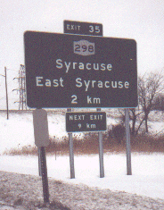
around Syracuse
Syracuse, New York
Syracuse is a city in and the county seat of Onondaga County, New York, United States, the largest U.S. city with the name "Syracuse", and the fifth most populous city in the state. At the 2010 census, the city population was 145,170, and its metropolitan area had a population of 742,603...
, which is about 100 miles (161 km) from Ontario
Ontario
Ontario is a province of Canada, located in east-central Canada. It is Canada's most populous province and second largest in total area. It is home to the nation's most populous city, Toronto, and the nation's capital, Ottawa....
. The NYS Thruway Authority decided to test metric signage, which may have briefly included an 88 km/h speed limit sign, on the Thruway. There was also a sign displaying the distance to the Interstate 81
Interstate 81
Interstate 81 is an Interstate Highway in the eastern part of the United States. Its southern terminus is at Interstate 40 in Dandridge, Tennessee; its northern terminus is on Wellesley Island at the Canadian border, where the Thousand Islands Bridge connects it to Highway 401, the main freeway...
interchange in kilometers in Dewitt. These signs are now displayed in just miles.
I-90 is one of two Interstates having a complete set of nine spur route
Spur route
A spur route is a short road forming a branch from a longer, more important route . A bypass or beltway is never considered a true spur route as it typically reconnects with the major road...
s (190, 290, 390...890, 990) within one state, in New York
New York
New York is a state in the Northeastern region of the United States. It is the nation's third most populous state. New York is bordered by New Jersey and Pennsylvania to the south, and by Connecticut, Massachusetts and Vermont to the east...
, with the other being Interstate 5, in California. In addition, I-990, a short spur route near Buffalo
Buffalo, New York
Buffalo is the second most populous city in the state of New York, after New York City. Located in Western New York on the eastern shores of Lake Erie and at the head of the Niagara River across from Fort Erie, Ontario, Buffalo is the seat of Erie County and the principal city of the...
, New York not directly connected to I-90, is the highest number given to an Interstate.
I-790 in Utica used to have a completely direct connection with I-90 at Thruway interchange 31. Various road redesign projects over the years have eventually led to this direct connection being partially severed. Traffic exiting the Thruway must use two different surface streets to reach I-790. However, it is still possible to travel from I-790 directly onto the Thruway. I-790 has some other oddities: no exit numbers, no reassurance marker
Reassurance marker
A reassurance marker or road identification sign is a road sign that repeats the name or number of the current route. Typically posted at intervals alongside a numbered highway, the signs are intended to reassure drivers that they are traveling on the desired road .- North America :In the United...
s, and it runs concurrent with New York State Route 5
New York State Route 5
New York State Route 5 is a state highway that extends for across the state of New York in the United States. It begins at the Pennsylvania state line in the Chautauqua County town of Ripley and passes through Buffalo, Syracuse, Utica, Schenectady, and several other smaller cities and...
for its entire length.
The New York section of I-90 west of the Berkshire Section of the New York Thruway is defined as Interstate Route 504 in New York Highway Law § 340-a.
Massachusetts
I-90 in Massachusetts runs along the pre-Interstate era Massachusetts TurnpikeMassachusetts Turnpike
The Massachusetts Turnpike is the easternmost stretch of Interstate 90. The Turnpike begins at the western border of Massachusetts in West Stockbridge connecting with the Berkshire Connector portion of the New York State Thruway...
, which opened on May 15, 1957, from West Stockbridge at the New York state border to Route 128.
The first section of the Boston Extension opened in September 1964 from the original terminus at Route 128 to the Allston/Brighton Tolls. The entire Boston Extension opened on February 18, 1965 continuing from the Allston/Brighton Tolls to I-93
Interstate 93
Interstate 93 is an Interstate Highway in the New England section of the United States. Its southern terminus is in Canton, Massachusetts, in the Boston metropolitan area, at Interstate 95; its northern terminus is near St. Johnsbury, Vermont, at Interstate 91...
in Downtown Boston. The new extension added 12 miles (19.3 km) to the MassPike's original 123.
I-90 was extended again as part of the Big Dig from its terminus at I-93 to Boston's Logan International Airport
Logan International Airport
General Edward Lawrence Logan International Airport is located in the East Boston neighborhood of Boston, Massachusetts . It covers , has six runways, and employs an estimated 16,000 people. It is the 19th busiest airport in the United States.Boston serves as a focus city for JetBlue Airways...
and a terminus of Route 1A
Route 1A (Massachusetts)
Route 1A is a south–north state highway in Massachusetts. It is an alternate route to U.S. 1 with three signed sections and two unsigned sections where the highway is concurrent with its parent...
in January 2003 via tunnels under the Fort Point Channel and the Ted Williams Tunnel
Ted Williams Tunnel
The Ted Williams Tunnel, also known as the Williams Tunnel, is the name of the third highway tunnel under Boston Harbor in Boston, Massachusetts, the Sumner and Callahan Tunnels being the other two...
under Boston Harbor. This extended I-90 by an additional 1.3 miles (2.1 km), shifting the eastern terminus to Route 1A.
Turnpike Doubles are permitted to travel between exit 11 and through the New York state border.
History
I-90 made heavy use of existing roads. The Massachusetts TurnpikeMassachusetts Turnpike
The Massachusetts Turnpike is the easternmost stretch of Interstate 90. The Turnpike begins at the western border of Massachusetts in West Stockbridge connecting with the Berkshire Connector portion of the New York State Thruway...
, New York State Thruway
New York State Thruway
The New York State Thruway is a system of limited-access highways located within the state of New York in the United States. The system, known officially as the Governor Thomas E. Dewey Thruway for former New York Governor Thomas E. Dewey, is operated by the New York State Thruway Authority and...
, Ohio Turnpike
Ohio Turnpike
The Ohio Turnpike, officially the James W. Shocknessy Ohio Turnpike, is a -long, limited-access toll highway in the U.S. state of Ohio, serving as a primary corridor to Chicago and Pittsburgh...
, Indiana Toll Road
Indiana Toll Road
The Indiana Toll Road, officially the Indiana East–West Toll Road, is a toll road that runs for east–west across northern Indiana from the Illinois state line to the Ohio state line...
, Chicago Skyway
Chicago Skyway
The Chicago Skyway, also known as Chicago Skyway Toll Bridge System, is a toll road in Chicago, Illinois, United States, carrying Interstate 90 from the Indiana Toll Road to the Dan Ryan Expressway on Chicago's South Side leading into the Chicago Loop....
, and the Jane Addams Memorial Tollway all predate I-90 and were used for parts of its route. This also means that substantial portions of the route are not precisely to Interstate Highway standards
Interstate Highway standards
Standards for Interstate Highways in the United States are defined by the American Association of State Highway and Transportation Officials in the publication A Policy on Design Standards - Interstate System...
, but they are usually close.
The popular TV sitcom Cheers
Cheers
Cheers is an American situation comedy television series that ran for 11 seasons from 1982 to 1993. It was produced by Charles/Burrows/Charles Productions, in association with Paramount Network Television for NBC, and was created by the team of James Burrows, Glen Charles, and Les Charles...
was set in Boston, on the east end of I-90. When the spin-off Frasier
Frasier
Frasier is an American sitcom that was broadcast on NBC for eleven seasons, from September 16, 1993, to May 13, 2004. The program was created and produced by David Angell, Peter Casey, and David Lee in association with Grammnet and Paramount Network Television.A spin-off of Cheers, Frasier stars...
was being developed, it was decided to set that series as far from Boston as possible, so Seattle, on the west end of I-90, was chosen as the setting.
Major intersections
- Interstate 5Interstate 5Interstate 5 is the main Interstate Highway on the West Coast of the United States, running largely parallel to the Pacific Ocean coastline from Canada to Mexico . It serves some of the largest cities on the U.S...
in Seattle, WashingtonSeattle, WashingtonSeattle is the county seat of King County, Washington. With 608,660 residents as of the 2010 Census, Seattle is the largest city in the Northwestern United States. The Seattle metropolitan area of about 3.4 million inhabitants is the 15th largest metropolitan area in the country... - Interstate 405Interstate 405 (Washington)Interstate 405 in Washington is a stretch of freeway that bypasses Seattle east of Lake Washington. The northern terminus is in Lynnwood and the southern terminus is in Tukwila...
in Bellevue, WashingtonBellevue, WashingtonBellevue is a city in the Eastside region of King County, Washington, United States, across Lake Washington from Seattle. Long known as a suburb or satellite city of Seattle, it is now categorized as an edge city or a boomburb. The population was 122,363 at the 2010 census.Downtown Bellevue is... - Interstate 82Interstate 82Interstate 82 is a Interstate Highway that extends from I-90 in Ellensburg, Washington to I-84 near Umatilla, Oregon in the United States. In the state of Washington, it serves the cities of Ellensburg, Yakima, and the Tri Cities , and in Oregon, it serves Umatilla and Hermiston...
in Ellensburg, WashingtonEllensburg, WashingtonEllensburg is a city in, and the county seat of, Kittitas County, Washington, United States. The population was 18,174 at the 2010 census. The population was 18,250 at 2011 Estimate from Office of Financial Management. Ellensburg is located just east of the Cascade Range on I-90 and is known as the... - Interstate 15 in Butte, MontanaButte, MontanaButte is a city in Montana and the county seat of Silver Bow County, United States. In 1977, the city and county governments consolidated to form the sole entity of Butte-Silver Bow. As of the 2010 census, Butte's population was 34,200...
; joined for 7.65 miles (12.31 km) - Interstate 94Interstate 94Interstate 94 is the northernmost east–west Interstate Highway, connecting the Great Lakes and Intermountain regions of the United States. I-94's western terminus is in Billings, Montana at a junction with Interstate 90; its eastern terminus is the U.S...
in Billings, MontanaBillings, MontanaBillings is the largest city in the U.S. state of Montana, and is the principal city of the Billings Metropolitan Area, the largest metropolitan area in over... - Interstate 25Interstate 25Interstate 25 is an Interstate Highway in the western United States. It is primarily a north–south highway. I-25 stretches from Interstate 10 at Las Cruces, New Mexico, , to Interstate 90 in Buffalo, Wyoming, .Interstate 25 is the main north–south expressway through...
in Buffalo, WyomingBuffalo, WyomingBuffalo is a city in Johnson County, Wyoming, United States. The population was 3,900 at the 2000 census. It is the county seat of Johnson County... - Interstate 29Interstate 29Interstate 29 is an Interstate Highway in the Midwestern United States. I-29 runs from Kansas City, Missouri, at a junction with Interstate 35 and Interstate 70 to the Canadian border near Pembina, North Dakota, where it connects with Manitoba Highway 75 via the short Manitoba Highway 29.-Route...
in Sioux Falls, South DakotaSioux Falls, South DakotaSioux Falls is the largest city in the U.S. state of South Dakota. Sioux Falls is the county seat of Minnehaha County, and also extends into Lincoln County to the south... - Interstate 35Interstate 35Interstate 35 is a north–south Interstate Highway in the central United States. I-35 stretches from Laredo, Texas, on the U.S.-Mexico border to Duluth, Minnesota, at Minnesota Highway 61 and 26th Avenue East. Many interstates used to have splits or spurs indicated with suffixed letters , but I-35...
in Albert Lea, MinnesotaAlbert Lea, MinnesotaAlbert Lea is a city in and the county seat of Freeborn County in the southeastern part of the U.S. state of Minnesota. The population was 18,016 at the 2010 census.... - Interstate 94Interstate 94Interstate 94 is the northernmost east–west Interstate Highway, connecting the Great Lakes and Intermountain regions of the United States. I-94's western terminus is in Billings, Montana at a junction with Interstate 90; its eastern terminus is the U.S...
in Tomah, WisconsinTomah (town), WisconsinTomah is a town in Monroe County, Wisconsin, United States. The population was 1,194 at the 2000 census. The city of Tomah, Wisconsin lies partially within its limits.-Geography:...
; joined for 91.76 miles (147.67 km) until Madison, WisconsinMadison, WisconsinMadison is the capital of the U.S. state of Wisconsin and the county seat of Dane County. It is also home to the University of Wisconsin–Madison....
. - Interstate 39Interstate 39Interstate 39 is a highway in the midwestern United States. I-39 runs from Normal, Illinois at Interstate 55 to Highway 29 in Rothschild, Wisconsin, approximately six miles south of Wausau. I-39 was designed to replace US Highway 51, which in the early 1980s was one of the busiest two-lane...
in Portage, WisconsinPortage, WisconsinPortage is a city in and the county seat of Columbia County, Wisconsin, United States. The population was 10,662 at the 2010 census making it the largest city in Columbia County...
; joined for about 95 miles (152 km) until Rockford, IllinoisRockford, IllinoisRockford is a mid-sized city located on both banks of the Rock River in far northern Illinois. Often referred to as "The Forest City", Rockford is the county seat of Winnebago County, Illinois, USA. As reported in the 2010 U.S. census, the city was home to 152,871 people, the third most populated...
. - Interstate 43Interstate 43Interstate 43 is a intrastate Interstate Highway located entirely within the U.S. state of Wisconsin, connecting Interstate 39 and Interstate 90 in Beloit with Milwaukee and U.S. Route 41 and U.S. Route 141 in Green Bay. I-43 is the 5th longest intrastate Interstate Highway of the Interstate...
in Beloit, WisconsinBeloit, WisconsinBeloit is a city in Rock County, Wisconsin, United States. As of the 2010 census, Beloit had a population of 36,966. The greater Beloit area is home to more than 91,000 residents.-Claim to fame:... - Interstate 94Interstate 94Interstate 94 is the northernmost east–west Interstate Highway, connecting the Great Lakes and Intermountain regions of the United States. I-94's western terminus is in Billings, Montana at a junction with Interstate 90; its eastern terminus is the U.S...
in Chicago, Illinois; joined for 16.71 miles (26.89 km) - Interstate 55Interstate 55Interstate 55 is an Interstate Highway in the central United States. Its odd number indicates that it is a north–south Interstate Highway. I-55 goes from LaPlace, Louisiana at Interstate 10 to Chicago at U.S. Route 41 , at McCormick Place. A common nickname for the highway is "double...
in Chicago, Illinois - Interstate 65Interstate 65Interstate 65 is a major Interstate Highway in the United States. The southern terminus is located at an intersection with Interstate 10 in Mobile, Alabama, and its northern terminus is at an interchange with Interstate 90 , U.S. Route 12, and U.S...
in Gary, IndianaGary, IndianaGary is a city in Lake County, Indiana, United States. The city is in the southeastern portion of the Chicago metropolitan area and is 25 miles from downtown Chicago. The population is 80,294 at the 2010 census, making it the seventh-largest city in the state. It borders Lake Michigan and is known... - Interstate 94Interstate 94Interstate 94 is the northernmost east–west Interstate Highway, connecting the Great Lakes and Intermountain regions of the United States. I-94's western terminus is in Billings, Montana at a junction with Interstate 90; its eastern terminus is the U.S...
in Lake Station, IndianaLake Station, IndianaLake Station is a city in Lake County, Indiana, United States. The population was 12,572 at the 2010 census.-History:An early depot stop on the Michigan Central Railroads Detroit to Chicago line through the Calumet region, the village was first named when George Earle mapped out a town of about in... - Interstate 80Interstate 80Interstate 80 is the second-longest Interstate Highway in the United States, following Interstate 90. It is a transcontinental artery running from downtown San Francisco, California to Teaneck, New Jersey in the New York City Metropolitan Area...
in Lake Station, IndianaLake Station, IndianaLake Station is a city in Lake County, Indiana, United States. The population was 12,572 at the 2010 census.-History:An early depot stop on the Michigan Central Railroads Detroit to Chicago line through the Calumet region, the village was first named when George Earle mapped out a town of about in...
; joined for 278.40 miles (448.04 km) until LorainLorain, OhioLorain is a city in Lorain County, Ohio, United States. The municipality is located in northeastern Ohio on Lake Erie, at the mouth of the Black River, about 30 miles west of Cleveland....
, Ohio. - Interstate 69Interstate 69Interstate 69 is an Interstate Highway in the United States. It exists in two parts: a completed highway from Indianapolis, Indiana, northeast to the Canadian border in Port Huron, Michigan, and a mostly proposed extension southwest to the Mexican border in Texas...
in Fremont, IndianaFremont, IndianaFremont is a town in Fremont Township, Steuben County, Indiana, United States. The population was 2,138 at the 2010 census. Settled in 1834 as Willow Prairie, it became the Village of Brockville when it was platted in 1837. In 1848, it was renamed to honor John C... - Interstate 75Interstate 75Interstate 75 is a major north–south Interstate Highway in the Great Lakes and Southeastern regions of the United States. It travels from State Road 826 and State Road 924 in Hialeah, Florida to Sault Ste. Marie, Michigan, at the Ontario, Canada, border...
in Toledo, OhioToledo, OhioToledo is the fourth most populous city in the U.S. state of Ohio and is the county seat of Lucas County. Toledo is in northwest Ohio, on the western end of Lake Erie, and borders the State of Michigan... - Interstate 71Interstate 71Interstate 71 is an Interstate Highway in the Great Lakes/Midwestern and Southeastern region of the United States. Its southern terminus is at an interchange with Interstate 64 and Interstate 65 in Louisville, Kentucky. Its northern terminus is at an interchange with Interstate 90 in Cleveland,...
in Cleveland, OhioCleveland, OhioCleveland is a city in the U.S. state of Ohio and is the county seat of Cuyahoga County, the most populous county in the state. The city is located in northeastern Ohio on the southern shore of Lake Erie, approximately west of the Pennsylvania border... - Interstate 77Interstate 77Interstate 77 is an Interstate Highway in the eastern United States. It traverses diverse terrain, from the mountainous state of West Virginia to the rolling farmlands of North Carolina and Ohio. It largely supplants the old U.S...
in Cleveland, OhioCleveland, OhioCleveland is a city in the U.S. state of Ohio and is the county seat of Cuyahoga County, the most populous county in the state. The city is located in northeastern Ohio on the southern shore of Lake Erie, approximately west of the Pennsylvania border... - Interstate 271Interstate 271Interstate 271 is an auxiliary interstate highway in the suburbs of Cleveland and Akron in the U.S. state of Ohio. The highway is officially designated the "Cleveland Outerbelt East", but rarely referred to by that name.-Route description:...
in Willoughby, OhioWilloughby, OhioAs of the census of 2000, there were 22,621 people, 10,265 households, and 5,892 families residing in the city. The population density was 2,225.3 people per square mile . There were 10,700 housing units at an average density of 1,052.6 per square mile... - Interstate 79Interstate 79Interstate 79 is an Interstate Highway in the eastern United States, designated from Interstate 77 in Charleston, West Virginia to Pennsylvania Route 5 and Pennsylvania Route 290 in Erie, Pennsylvania...
in Erie, PennsylvaniaErie, PennsylvaniaErie is a city located in northwestern Pennsylvania in the United States. Named for the lake and the Native American tribe that resided along its southern shore, Erie is the state's fourth-largest city , with a population of 102,000... - Interstate 86Interstate 86 (east)Interstate 86 is an Interstate Highway that extends for through northwestern Pennsylvania and southern New York in the United States...
in Erie, PennsylvaniaErie, PennsylvaniaErie is a city located in northwestern Pennsylvania in the United States. Named for the lake and the Native American tribe that resided along its southern shore, Erie is the state's fourth-largest city , with a population of 102,000... - Interstate 81Interstate 81Interstate 81 is an Interstate Highway in the eastern part of the United States. Its southern terminus is at Interstate 40 in Dandridge, Tennessee; its northern terminus is on Wellesley Island at the Canadian border, where the Thousand Islands Bridge connects it to Highway 401, the main freeway...
in Syracuse, New YorkSyracuse, New YorkSyracuse is a city in and the county seat of Onondaga County, New York, United States, the largest U.S. city with the name "Syracuse", and the fifth most populous city in the state. At the 2010 census, the city population was 145,170, and its metropolitan area had a population of 742,603... - Interstate 88Interstate 88 (east)Interstate 88 is an intrastate Interstate Highway entirely within the U.S. state of New York. Its western end is at Interstate 81 in Binghamton and its eastern end is at Interstate 90 in Schenectady. It serves as an important connector route from Albany to Binghamton, Elmira , and...
in Rotterdam, New York - Interstate 87Interstate 87Interstate 87 is a Interstate Highway located entirely within New York State in the United States of America. I-87 is the longest intrastate Interstate highway in the Interstate Highway System. Its southern end is at the Bronx approaches of the Robert F. Kennedy Bridge in New York City...
in Albany, New YorkAlbany, New YorkAlbany is the capital city of the U.S. state of New York, the seat of Albany County, and the central city of New York's Capital District. Roughly north of New York City, Albany sits on the west bank of the Hudson River, about south of its confluence with the Mohawk River... - Interstate 91Interstate 91Interstate 91 is an Interstate Highway in the New England region of the United States. It provides the primary north–south thoroughfare in the western part of New England...
in West Springfield, MassachusettsWest Springfield, MassachusettsThe Town of West Springfield is a city in Hampden County, Massachusetts, United States. It is part of the Springfield, Massachusetts Metropolitan Statistical Area. The population was 28,391 at the 2010 census... - Interstate 291Interstate 291 (Massachusetts)Interstate 291 is a connector highway in Massachusetts that links Interstate 91 in downtown Springfield with Interstate 90 in Chicopee. I-291 is roughly a northeast/southwest highway. It merges with I-91 at its southwestern terminus, via a flyover...
in Chicopee, MassachusettsChicopee, MassachusettsChicopee is a city located on the Connecticut River in Hampden County, Massachusetts, United States of America. It is part of the Springfield, Massachusetts Metropolitan Statistical Area. As of the 2010 census, the city had a total population of 55,298, making it the second largest city in... - Interstate 84Interstate 84 (east)Interstate 84 is an Interstate Highway extending from Dunmore, Pennsylvania at an interchange with Interstate 81 to Sturbridge, Massachusetts, at an interchange with the Massachusetts Turnpike . I-84 has mile-log junction numbering in Pennsylvania; otherwise, exit numbers are roughly sequential...
in Sturbridge, MassachusettsSturbridge, MassachusettsSturbridge is a town in Worcester County, Massachusetts, United States. It is home to Old Sturbridge Village living history museum and other sites of historical interest such as Tantiusques.The population was 9,268 at the 2010 census... - Interstate 395Interstate 395 (Connecticut)Interstate 395 is a 67-mile-long north–south Interstate Highway that begins at Interstate 95 in East Lyme, Connecticut and ends at Interstate 90 in Auburn, Massachusetts, where it becomes Interstate 290. The original designation for the freeway was Route 52...
in Auburn, MassachusettsAuburn, MassachusettsAuburn is a town in Worcester County, Massachusetts, United States. The population was 16,188 at the 2010 census.- History :Auburn was first settled in 1789 and was officially incorporated in 1808 as the town of Ward, in honor of American Revolution General Artemas Ward... - Interstate 495Interstate 495 (Massachusetts)Interstate 495 is the designation of an Interstate Highway half-beltway in Massachusetts. It was the longest auxiliary Interstate Highway of its kind—measuring 120.74 miles —until 1996, when the PA Route 9 section of the Pennsylvania Turnpike was redesignated as Interstate 476, making it about ...
in Hopkinton, MassachusettsHopkinton, MassachusettsHopkinton is a town in Middlesex County, Massachusetts, just under 30 miles west and south of Boston. The town is best known as the starting point of the Boston Marathon, held annually on Patriots' Day in April, and as the home of computer storage firm EMC Corporation.For geographic and demographic... - Interstate 95Interstate 95 in MassachusettsInterstate 95 is the main highway on the East Coast of the United States, paralleling the Atlantic Ocean from Florida to Maine. The Massachusetts portion of the highway enters from the state of Rhode Island in Attleboro and travels in a northeasterly direction to the junction with Route 128 in...
in Weston, MassachusettsWeston, MassachusettsWeston is a suburb of Boston located in Middlesex County, Massachusetts, United States in the Boston metro area. The population of Weston, according to the 2010 U.S. Census, is 11,261.... - Interstate 93Interstate 93Interstate 93 is an Interstate Highway in the New England section of the United States. Its southern terminus is in Canton, Massachusetts, in the Boston metropolitan area, at Interstate 95; its northern terminus is near St. Johnsbury, Vermont, at Interstate 91...
in Boston, Massachusetts
Auxiliary routes
- Rapid City, South DakotaRapid City, South DakotaRapid City is the second-largest city in the U.S. state of South Dakota, and the county seat of Pennington County. Named after Rapid Creek on which the city is established, it is set against the eastern slope of the Black Hills mountain range. The population was 67,956 as of the 2010 Census. Rapid...
- I-190Interstate 190 (South Dakota)Interstate 190 is an auxiliary Interstate Highway in the U.S. state of South Dakota. The route runs for about two miles south, connecting I-90 to downtown Rapid City. The entire length overlaps U.S. Route 16. It is the westernmost auxiliary route of Interstate 90, approximately 1150 miles east... - Chicago, Illinois - I-190Interstate 190 (Illinois)Interstate 190 is an intrastate Interstate Highway in the U.S. state of Illinois. I-190 runs west from I-90 to O'Hare International Airport. This is a distance of . Interstate 190 is the westernmost leg of the Kennedy Expressway...
(provides a direct route to O'Hare International AirportO'Hare International AirportChicago O'Hare International Airport , also known as O'Hare Airport, O'Hare Field, Chicago Airport, Chicago International Airport, or simply O'Hare, is a major airport located in the northwestern-most corner of Chicago, Illinois, United States, northwest of the Chicago Loop...
), I-290Interstate 290 (Illinois)Interstate 290 is a main Interstate freeway that runs westwards from the Chicago Loop. A portion of I-290 is officially called the Dwight D. Eisenhower Expressway. In short form, it is known as "the Ike" or the Eisenhower... - Cleveland, OhioCleveland, OhioCleveland is a city in the U.S. state of Ohio and is the county seat of Cuyahoga County, the most populous county in the state. The city is located in northeastern Ohio on the southern shore of Lake Erie, approximately west of the Pennsylvania border...
- I-490Interstate 490 (Ohio)Interstate 490 is a Interstate Highway in Cleveland, Ohio. The western terminus is a junction with I-90 and I-71 on Cleveland's west side. After spanning the Cuyahoga River, the eastern terminus is a junction with East 55th Street, just east of I-77.... - Buffalo, New YorkBuffalo, New YorkBuffalo is the second most populous city in the state of New York, after New York City. Located in Western New York on the eastern shores of Lake Erie and at the head of the Niagara River across from Fort Erie, Ontario, Buffalo is the seat of Erie County and the principal city of the...
- I-190Interstate 190 (New York)Interstate 190 runs 28.34 miles from Interstate 90 near Buffalo, New York to Lewiston, New York via Niagara Falls. Parts of this highway were built on the former rights-of-way of the Lehigh Valley Railroad and the Erie Canal. It is referred to by locals as The One-Ninety...
, I-290Interstate 290 (New York)Interstate 290 runs for near Buffalo, New York from I-90 to I-190. It connects Buffalo with its northern suburbs of Amherst and Tonawanda, and provides a route to Niagara Falls that bypasses the city of Buffalo. I-290 also connects to Interstate 990, and through this connection,...
, I-990Interstate 990Interstate 990 is an auxiliary Interstate Highway located entirely within the town of Amherst in Erie County, New York, in the United States. It runs in a roughly north–south direction for through the southwestern and central parts of Amherst from Interstate 290 north of Buffalo to...
(not directly connected) - Rochester, New York - I-390Interstate 390Interstate 390 is a north–south auxiliary Interstate Highway located entirely within New York in the United States. The southern terminus of the route is at the Southern Tier Expressway in the town of Avoca. Its northern terminus is at I-490 in Rochester...
, I-490Interstate 490 (New York)Interstate 490 is an auxiliary Interstate Highway that serves the city of Rochester, New York, in the United States. It acts as a northerly alternate route to the New York State Thruway , leaving it at exit 47 in the town of Le Roy and rejoining the highway at exit 45 in the town of...
, I-590Interstate 590Interstate 590 is a north–south auxiliary Interstate Highway that serves the immediate southeastern suburbs of the city of Rochester, New York, in the United States. It extends for from an interchange with I-390 in Brighton to the Can of Worms, a complex interchange connecting I-590 to I-490...
(not directly connected) - Syracuse, New YorkSyracuse, New YorkSyracuse is a city in and the county seat of Onondaga County, New York, United States, the largest U.S. city with the name "Syracuse", and the fifth most populous city in the state. At the 2010 census, the city population was 145,170, and its metropolitan area had a population of 742,603...
- I-690Interstate 690Interstate 690 is an auxiliary Interstate Highway that extends for through the vicinity of Syracuse, New York, in the United States. It is a spur of I-90 that travels southeast from Thruway exit 39 in Van Buren to I-481 in DeWitt... - Utica, New YorkUtica, New YorkUtica is a city in and the county seat of Oneida County, New York, United States. The population was 62,235 at the 2010 census, an increase of 2.6% from the 2000 census....
- I-790Interstate 790Interstate 790 is an auxiliary Interstate Highway in the city of Utica, New York, in the United States. It runs for from an interchange with NY 5A and NY 5S in downtown Utica to exit 31 of the New York State Thruway east of the city... - Schenectady, New YorkSchenectady, New YorkSchenectady is a city in Schenectady County, New York, United States, of which it is the county seat. As of the 2010 census, the city had a population of 66,135...
- I-890Interstate 890Interstate 890 is a long auxiliary Interstate Highway in the vicinity of Schenectady, New York, United States. The highway runs southeast–northwest from an interchange with the New York State Thruway northwest of Schenectady to another junction with the Thruway south of the city and passes... - Spur to I-495Interstate 495 (Massachusetts)Interstate 495 is the designation of an Interstate Highway half-beltway in Massachusetts. It was the longest auxiliary Interstate Highway of its kind—measuring 120.74 miles —until 1996, when the PA Route 9 section of the Pennsylvania Turnpike was redesignated as Interstate 476, making it about ...
in Marlborough, MassachusettsMarlborough, MassachusettsMarlborough is a city in Middlesex County, Massachusetts, United States. The population was 38,499 at the 2010 census. Marlborough became a prosperous industrial town in the 19th century and made the transition to high technology industry in the late 20th century after the construction of the...
- I-290Interstate 290 (Massachusetts)Interstate 290 runs for from Auburn, Massachusetts to Marlborough, Massachusetts. It is a continuation of I-395 north of I-90 and runs through downtown Worcester, Massachusetts, I-190 splits off, and I-290 runs across Lake Quinsigamond and east to I-495 in Marlborough... - Spur to Leominster, MassachusettsLeominster, MassachusettsLeominster is a city in Worcester County, Massachusetts, United States. It is the second-largest city in Worcester County, with a population of 40,759 at the 2010 census. Leominster is located north of Worcester and west of Boston. Both Route 2 and Route 12 pass through Leominster. Interstate 190,...
- I-190Interstate 190 (Massachusetts)Interstate 190 runs for north from I-290 in Worcester, Massachusetts to Route 2 in Leominster, Massachusetts. A portion of the highway was built with extra-wide shoulders, which are painted green, to prevent runoff from contaminating the nearby Wachusett Reservoir...
I-90 is the only interstate to have a complete set of auxiliary routes (i.e., all nine possible three-digit route numbers) within a single state, that being New York
New York
New York is a state in the Northeastern region of the United States. It is the nation's third most populous state. New York is bordered by New Jersey and Pennsylvania to the south, and by Connecticut, Massachusetts and Vermont to the east...
.