
Sacramento, California
Overview
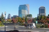
Sacramento is the capital city of the U.S. state
of California
and the county seat
of Sacramento County
. It is located at the confluence of the Sacramento River
and the American River
in the northern portion of California's expansive Central Valley
. With a population of 466,488 at the 2010 census, it is the sixth-largest city in California. Sacramento is the core cultural and economic center of the Sacramento metropolitan area
which includes seven counties; with an estimated population of 2,527,123.
U.S. state
A U.S. state is any one of the 50 federated states of the United States of America that share sovereignty with the federal government. Because of this shared sovereignty, an American is a citizen both of the federal entity and of his or her state of domicile. Four states use the official title of...
of California
California
California is a state located on the West Coast of the United States. It is by far the most populous U.S. state, and the third-largest by land area...
and the county seat
County seat
A county seat is an administrative center, or seat of government, for a county or civil parish. The term is primarily used in the United States....
of Sacramento County
Sacramento County, California
Sacramento County is a county in the U.S. state of California. Its county seat is Sacramento, which is also the state capital. As of 2010 the county had a population of 1,418,788....
. It is located at the confluence of the Sacramento River
Sacramento River
The Sacramento River is an important watercourse of Northern and Central California in the United States. The largest river in California, it rises on the eastern slopes of the Klamath Mountains, and after a journey south of over , empties into Suisun Bay, an arm of the San Francisco Bay, and...
and the American River
American River
The American River is a California watercourse noted as the site of Sutter's Mill, northwest of Placerville, California, where gold was found in 1848, leading to the California Gold Rush...
in the northern portion of California's expansive Central Valley
California Central Valley
California's Central Valley is a large, flat valley that dominates the central portion of California. It is home to California's most productive agricultural efforts. The valley stretches approximately from northwest to southeast inland and parallel to the Pacific Ocean coast. Its northern half is...
. With a population of 466,488 at the 2010 census, it is the sixth-largest city in California. Sacramento is the core cultural and economic center of the Sacramento metropolitan area
Sacramento metropolitan area
The Greater Sacramento area, or officially Sacramento–Arden Arcade–Yuba City, CA-NV Combined Statistical Area, is a combined statistical area consisting of several metropolitan statistical areas and seven counties in Northern California and one in Western Nevada. These are Sacramento, Yolo, El...
which includes seven counties; with an estimated population of 2,527,123.
Discussions