
Vancouver Island
Encyclopedia
Island
An island or isle is any piece of sub-continental land that is surrounded by water. Very small islands such as emergent land features on atolls can be called islets, cays or keys. An island in a river or lake may be called an eyot , or holm...
in British Columbia
British Columbia
British Columbia is the westernmost of Canada's provinces and is known for its natural beauty, as reflected in its Latin motto, Splendor sine occasu . Its name was chosen by Queen Victoria in 1858...
, Canada
Canada
Canada is a North American country consisting of ten provinces and three territories. Located in the northern part of the continent, it extends from the Atlantic Ocean in the east to the Pacific Ocean in the west, and northward into the Arctic Ocean...
. It is one of several North American
North American
North American generally refers to an entity, people, group, or attribute of North America, especially of the United States and Canada together.-Culture:*North American English, a collective term used to describe American English and Canadian English...
locations named after George Vancouver
George Vancouver
Captain George Vancouver RN was an English officer of the British Royal Navy, best known for his 1791-95 expedition, which explored and charted North America's northwestern Pacific Coast regions, including the coasts of contemporary Alaska, British Columbia, Washington and Oregon...
, the British Royal Navy
Royal Navy
The Royal Navy is the naval warfare service branch of the British Armed Forces. Founded in the 16th century, it is the oldest service branch and is known as the Senior Service...
officer who explored the Pacific Northwest
Pacific Northwest
The Pacific Northwest is a region in northwestern North America, bounded by the Pacific Ocean to the west and, loosely, by the Rocky Mountains on the east. Definitions of the region vary and there is no commonly agreed upon boundary, even among Pacific Northwesterners. A common concept of the...
coast of North America between 1791 and 1794. While the city of Vancouver
Vancouver
Vancouver is a coastal seaport city on the mainland of British Columbia, Canada. It is the hub of Greater Vancouver, which, with over 2.3 million residents, is the third most populous metropolitan area in the country,...
is located on the North American mainland, Victoria
Victoria, British Columbia
Victoria is the capital city of British Columbia, Canada and is located on the southern tip of Vancouver Island off Canada's Pacific coast. The city has a population of about 78,000 within the metropolitan area of Greater Victoria, which has a population of 360,063, the 15th most populous Canadian...
, the capital of British Columbia, is located on the island.
The island is 460 kilometres (285.8 mi) in length and 80 kilometres (49.7 mi) in width at its widest point. At 32134 km² (12,407 sq mi), Vancouver Island is the largest Pacific island east of New Zealand
New Zealand
New Zealand is an island country in the south-western Pacific Ocean comprising two main landmasses and numerous smaller islands. The country is situated some east of Australia across the Tasman Sea, and roughly south of the Pacific island nations of New Caledonia, Fiji, and Tonga...
,Isla Grande de Tierra del Fuego
Isla Grande de Tierra del Fuego
Isla Grande de Tierra del Fuego is an island near the southern tip of South America from which it is separated by the Strait of Magellan...
, off the southern tip of South America, is larger than Vancouver Island and has shores on both the Pacific Ocean and the Atlantic Ocean, but is not generally considered to be a "Pacific island". the largest island on the western side of North America, the world's 43rd largest island, Canada's 11th largest island, and Canada's second most populous island after the Island of Montreal
Island of Montreal
The Island of Montreal , in extreme southwestern Quebec, Canada, is located at the confluence of the Saint Lawrence and Ottawa Rivers. It is separated from Île Jésus by the Rivière des Prairies....
. The 2001 census
Canada 2001 Census
The Canada 2001 Census was a detailed enumeration of the Canadian population. Census day was May 15, 2001. On that day, Statistics Canada attempted to count every person in Canada. The total population count of Canada was 30,007,094. This was a 4% increase over 1996 Census of 28,846,761. In...
population was 656,312. British Columbia statistics in 2008 estimated the population at 740,876. Nearly half of these (331,491) live in Greater Victoria
Greater Victoria, British Columbia
Greater Victoria is located in British Columbia, Canada, on the southern tip of Vancouver Island. It is a cultural rather than political entity, usually defined as the thirteen easternmost municipalities of the Capital Regional District on Vancouver Island but also includes adjoining areas and...
. Other notable cities and towns on Vancouver Island include Nanaimo, Port Alberni, Parksville
Parksville, British Columbia
-Demographics:Parksville had a population of 10,993 people in 2006, which was an increase of 6.5% from the 2001 census count. The median household income in 2006 for Parksville was $55,524, which is below the British Columbia provincial average of $62,346....
, Courtenay
Courtenay, British Columbia
Courtenay is a city on the east coast of Vancouver Island, in the Canadian province of British Columbia. It is the largest city in the area commonly known as the Comox Valley, and it is the seat of the Comox Valley Regional District which replaced the Comox-Strathcona Regional District...
, and Campbell River
Campbell River, British Columbia
Campbell River is a coastal city in British Columbia on the east coast of Vancouver Island at the south end of Discovery Passage, which lies along the important coastal Inside Passage shipping route...
.
The island was originally named Quadra's and Vancouver's Island in commemoration of the friendly negotiations held by Spanish Commander of the Nootka Sound settlement
Fort San Miguel
For Angola fort, see Fortaleza de São MiguelFort San Miguel was a Spanish fortification at Friendly Cove in Nootka Sound , Vancouver Island....
Juan Francisco de la Bodega y Quadra
Juan Francisco de la Bodega y Quadra
Juan Francisco de la Bodega y Quadra was a Spanish naval officer born in Lima, Peru. Assigned to the Pacific coast Spanish Naval Department base at San Blas, in the Viceroyalty of New Spain , this navigator explored the Northwest Coast of North America as far north as present day Alaska.Juan...
, and British Naval Captain George Vancouver
George Vancouver
Captain George Vancouver RN was an English officer of the British Royal Navy, best known for his 1791-95 expedition, which explored and charted North America's northwestern Pacific Coast regions, including the coasts of contemporary Alaska, British Columbia, Washington and Oregon...
on Nootka Sound in 1792, to find a solution to the Nootka Crisis
Nootka Crisis
The Nootka Crisis was an international incident and political dispute between the Kingdom of Great Britain and the Kingdom of Spain, triggered by a series of events that took place during the summer of 1789 at Nootka Sound...
.
Indigenous people
Vancouver Island has been the homeland to many main indigenous peoplesIndigenous peoples of the Pacific Northwest Coast
The Indigenous peoples of the Pacific Northwest Coast are the pre-Columbian inhabitants of the Pacific Northwest Coast, their descendants, and many ethnic groups who identify with those historical peoples. They are now situated within the Canadian Province of British Columbia and the U.S...
for thousands of years. The groupings, by language, are the Kwakwaka'wakw
Kwakwaka'wakw
The Kwakwaka'wakw are an Indigenous group of First Nations peoples, numbering about 5,500, who live in British Columbia on northern Vancouver Island and the adjoining mainland and islands.Kwakwaka'wakw translates as "Those who speak Kwak'wala", describing the collective nations within the area that...
, Nuu-chah-nulth, and Coast Salish
Coast Salish
Coast Salish languages are a subgroup of the Salishan language family. These languages are spoken by First Nations or Native American peoples inhabiting the territory that is now the southwest coast of British Columbia around the Strait of Georgia and Washington state around Puget Sound...
. Kwakwaka'wakw territory includes northern and northwestern Vancouver Island and adjoining areas of the mainland, the Nuu-chah-nulth span most of the west coast, while the Coast Salish cover the southeastern Island and southernmost extremities along the Straits of Juan de Fuca. Their cultures are connected to the natural resources abundant in the area.
Kwakwaka'wakw
The Kwakwaka'wakw today number about 5,500, who live in British Columbia on northern Vancouver Island and the mainland. The autonym they prefer is Kwakwaka'wakw. Their indigenous language, part of the WakashanWakashan languages
Wakashan is a family of languages spoken in British Columbia around and on Vancouver Island, and in the northwestern corner of the Olympic Peninsula of Washington state, on the south side of the Strait of Juan de Fuca....
family, is Kwak'wala
Kwak'wala
Kwak'wala is the Indigenous language spoken by the Kwakwaka'wakw. It belongs to the Wakashan language family. There are about 250 Kwak'wala speakers today, which amounts to 5% of the Kwakwaka'wakw population...
. The name Kwakwaka'wakw means "speakers of Kwak'wala". The language is now spoken by less than 5% of the population—about 250 people. Today 17 separate tribes make up the Kwakwaka'wakw, who historically spoke the common language of kwak'wala
Kwak'wala
Kwak'wala is the Indigenous language spoken by the Kwakwaka'wakw. It belongs to the Wakashan language family. There are about 250 Kwak'wala speakers today, which amounts to 5% of the Kwakwaka'wakw population...
. Some Kwakwaka'wakw groups are now extinct. Kwak'wala is a Northern Wakashan language
Wakashan languages
Wakashan is a family of languages spoken in British Columbia around and on Vancouver Island, and in the northwestern corner of the Olympic Peninsula of Washington state, on the south side of the Strait of Juan de Fuca....
, a grouping shared with Haisla, Heiltsuk and Oowekyala. Kwakwaka'wakw centres of population on Vancouver Island include communities such as Fort Rupert
Fort Rupert, British Columbia
Fort Rupert is the site of a former Hudson's Bay Company fort which was built and first commanded by William Henry McNeill in 1849 and later by John Work. It is located near present-day Port Hardy, British Columbia on Vancouver Island....
, Alert Bay
Alert Bay, British Columbia
Alert Bay is a village on Cormorant Island, British Columbia, Canada. According to the 2006 census, 556 people live within the village.-Population:Slightly more than half of the village's 556 residents are First Nations people...
and Quatsino
Quatsino, British Columbia
Quatsino is a small hamlet of 91 people located on Quatsino Sound in Northern Vancouver Island, Canada only accessible by boat or float plane. Its nearest neighbour is Coal Harbour, to the east, about 20 minutes away by boat, and Port Alice, to the south, about 40 minutes away by boat...
, The Kwakwaka'wakw tradition of the potlatch
Potlatch
A potlatch is a gift-giving festival and primary economic system practiced by indigenous peoples of the Pacific Northwest Coast of Canada and United States. This includes Heiltsuk Nation, Haida, Nuxalk, Tlingit, Makah, Tsimshian, Nuu-chah-nulth, Kwakwaka'wakw, and Coast Salish cultures...
was banned by the federal government of Canada
Canada
Canada is a North American country consisting of ten provinces and three territories. Located in the northern part of the continent, it extends from the Atlantic Ocean in the east to the Pacific Ocean in the west, and northward into the Arctic Ocean...
in 1885, but has been revived in recent decades.
Nuu-chah-nulth
The Nuu-chah-nulth are indigenous peoples in Canada. Their traditional home is on the west coast of Vancouver Island. In pre-contact and early post-contact times, the number of nations was much greater, but as in the rest of the region, smallpox and other consequences of contact resulted in the disappearance of some groups, and the absorption of others into neighbouring groups.They were among the first Pacific peoples north of California to come into contact with Europeans, as the Spanish, Americans and British attempted to secure control of Pacific Northwest and the trade in otter pelts, with Nootka Sound
Nootka Sound
Nootka Sound is a complex inlet or sound of the Pacific Ocean on the rugged west coast of Vancouver Island, in the Canadian province of British Columbia. Historically also known as King George's Sound, as a strait it separates Vancouver Island and Nootka Island.-History:The inlet is part of the...
becoming a focus of these rivalries. The Nuu-chah-nulth speak a Southern Wakashan language
Wakashan languages
Wakashan is a family of languages spoken in British Columbia around and on Vancouver Island, and in the northwestern corner of the Olympic Peninsula of Washington state, on the south side of the Strait of Juan de Fuca....
and are closely related to the Makah of the Olympic Peninsula
Olympic Peninsula
The Olympic Peninsula is the large arm of land in western Washington state of the USA, that lies across Puget Sound from Seattle. It is bounded on the west by the Pacific Ocean, the north by the Strait of Juan de Fuca, and the east by Puget Sound. Cape Alava, the westernmost point in the contiguous...
, Washington State and Ditidaht.
Coast Salish
The Coast Salish are the largest of the southern groups. They are a loose grouping of many tribes with numerous distinct cultures and languages. On Vancouver Island, Coast Salish peoples territory traditionally spans from the northern limit of the Gulf of Georgia on the inside of Vancouver Island and covering most of southern Vancouver Island. Distinct nations within the Coast Salish peoples on Vancouver Island include the ChemainusChemainus First Nation
The Stz'uminus First Nation is a First Nations government located in southeastern Vancouver Island, British Columbia, Canada, near the town of Ladysmith, British Columbia. Stz'uminus First Nation is a member government of the Naut'sa mawt Tribal Council...
, the Comox of the Courtenay
Courtenay, British Columbia
Courtenay is a city on the east coast of Vancouver Island, in the Canadian province of British Columbia. It is the largest city in the area commonly known as the Comox Valley, and it is the seat of the Comox Valley Regional District which replaced the Comox-Strathcona Regional District...
area, the Cowichan of the Cowichan Valley
Cowichan Valley
The Cowichan Valley is a region around the Cowichan River and Cowichan Lake on Vancouver Island, in British Columbia, Canada. There is some debate as to the origin of the name Cowichan, which many believe to be an anglicized form of the First Nations tribal name Quw'utsun.Communities include...
, the Esquimalt
Esquimalt First Nation
The Esquimalt First Nation, also known as the Esquimalt Indian Band and Esquimalt Nation, is a First Nations band government of the Esquimalt people. Historically their village was located closer to Victoria proper, but today their main reserve is on the north shore of Esquimalt Harbour adjacent...
, the Saanich
Saanich
The Saanich or W̱SÁNEĆ are indigenous nations from the north coast of the Olympic Peninsula in Washington, the Gulf and San Juan Islands, southern Vancouver Island and the southern edge of the Lower Mainland in British Columbia.*BOḰEĆEN – Pauquachin...
of the Saanich Peninsula
Saanich Peninsula
The Saanich Peninsula is located north of Victoria, British Columbia, Canada. It is bounded by the Saanich Inlet on the west, and various straits of the Gulf of Georgia on the east, chiefly Haro Strait The exact southern boundary of what is referred to as the "Saanich Peninsula" is somewhat fluid...
, the Songhees
Songhees First Nation
The Songhees First Nation is a First Nations government on located around Victoria, British Columbia on southern Vancouver Island, British Columbia, Canada.-External links:*...
of the Victoria
Victoria, British Columbia
Victoria is the capital city of British Columbia, Canada and is located on the southern tip of Vancouver Island off Canada's Pacific coast. The city has a population of about 78,000 within the metropolitan area of Greater Victoria, which has a population of 360,063, the 15th most populous Canadian...
area and Snuneymuxw
Snuneymuxw First Nation
The Snuneymuxw First Nation is the band government of the Snuneymuxw of west-central Vancouver Island, British Columbia, Canada. The Snuneymuxw First Nation have lived along the eastern coast of south-central Vancouver Island, British Columbia for an estimated 5,000 years...
in the Nanaimo
Nanaimo, British Columbia
Nanaimo is a city on Vancouver Island in British Columbia, Canada. It has been dubbed the "Bathtub Racing Capital of the World" and "Harbour City". Nanaimo is also sometimes referred to as the "Hub City" because of its central location on Vancouver Island and due to the layout of the downtown...
area.
European exploration
EuropeEurope
Europe is, by convention, one of the world's seven continents. Comprising the westernmost peninsula of Eurasia, Europe is generally 'divided' from Asia to its east by the watershed divides of the Ural and Caucasus Mountains, the Ural River, the Caspian and Black Seas, and the waterways connecting...
ans began to explore the island in 1774, when rumours of Russia
Russia
Russia or , officially known as both Russia and the Russian Federation , is a country in northern Eurasia. It is a federal semi-presidential republic, comprising 83 federal subjects...
n fur traders caused Spain to send a number of expeditions to assert its long-held claims to the Pacific Northwest. The first expedition was that of the Santiago, under the command of Juan José Pérez Hernández
Juan José Pérez Hernández
Juan José Pérez Hernández , often simply Juan Pérez, was an 18th century Spanish explorer. He was the first European to sight, examine, name, and record the islands near present-day British Columbia, Canada...
. In 1775, a second Spanish expedition under the Spanish Peruvian
Spanish Peruvian
A Spanish Peruvian is a Peruvian citizen of Spanish descent. Among European Peruvians, the Spanish are the largest group of immigrants to settle in the country.-History:...
captain Juan Francisco de la Bodega y Quadra
Juan Francisco de la Bodega y Quadra
Juan Francisco de la Bodega y Quadra was a Spanish naval officer born in Lima, Peru. Assigned to the Pacific coast Spanish Naval Department base at San Blas, in the Viceroyalty of New Spain , this navigator explored the Northwest Coast of North America as far north as present day Alaska.Juan...
was sent. By 1776 Spanish exploration had reached Bucareli Bay
Bucareli Bay
Bucareli Bay is a bay in the Alexander Archipelago, in the southeastern part of the U.S. state of Alaska. It is located off the western coast of Prince of Wales Island, between Baker Island and Suemez Island. To the east it connects to various waterways, such as San Alberto Bay. To the west it...
including the mouth of the Columbia River
Columbia River
The Columbia River is the largest river in the Pacific Northwest region of North America. The river rises in the Rocky Mountains of British Columbia, Canada, flows northwest and then south into the U.S. state of Washington, then turns west to form most of the border between Washington and the state...
between Oregon
Oregon
Oregon is a state in the Pacific Northwest region of the United States. It is located on the Pacific coast, with Washington to the north, California to the south, Nevada on the southeast and Idaho to the east. The Columbia and Snake rivers delineate much of Oregon's northern and eastern...
and Washington, and Sitka Sound
Sitka Sound
Sitka Sound is a body of water near the city of Sitka, Alaska. It is bordered by Baranof Island to the south and the northeast, by Kruzof Island to the northwest and by the Pacific Ocean to the southwest...
.
Vancouver Island came to the attention of Britain after the third voyage of Captain James Cook
James Cook
Captain James Cook, FRS, RN was a British explorer, navigator and cartographer who ultimately rose to the rank of captain in the Royal Navy...
, who spent a month during 1778 at Nootka Sound
Nootka Sound
Nootka Sound is a complex inlet or sound of the Pacific Ocean on the rugged west coast of Vancouver Island, in the Canadian province of British Columbia. Historically also known as King George's Sound, as a strait it separates Vancouver Island and Nootka Island.-History:The inlet is part of the...
, on the island's western coast. Cook claimed it for the United Kingdom
United Kingdom
The United Kingdom of Great Britain and Northern IrelandIn the United Kingdom and Dependencies, other languages have been officially recognised as legitimate autochthonous languages under the European Charter for Regional or Minority Languages...
. The island's rich fur trading potential led the fur-trader John Meares
John Meares
John Meares was a navigator, explorer, and maritime fur trader, best known for his role in the Nootka Crisis, which brought Britain and Spain to the brink of war.- Career :...
to set up a single-building trading post near the native village of Yuquot (Friendly Cove), at the entrance to Nootka Sound. The building was removed by the end of 1788.
The island was further explored by Spain
Spain
Spain , officially the Kingdom of Spain languages]] under the European Charter for Regional or Minority Languages. In each of these, Spain's official name is as follows:;;;;;;), is a country and member state of the European Union located in southwestern Europe on the Iberian Peninsula...
in 1789 with Esteban José Martínez, who established the settlement of Yuquot and the artillery battery of Fort San Miguel
Fort San Miguel
For Angola fort, see Fortaleza de São MiguelFort San Miguel was a Spanish fortification at Friendly Cove in Nootka Sound , Vancouver Island....
at Friendly Cove, which Spain called Puerto de San Lorenzo de Nuca. This was to be the only Spanish settlement in what would later be Canada. Asserting their claim of exclusive sovereignty and navigation rights, the Spanish force seized the Portuguese-flagged
Flag of convenience
The term flag of convenience describes the business practice of registering a merchant ship in a sovereign state different from that of the ship's owners, and flying that state's civil ensign on the ship. Ships are registered under flags of convenience to reduce operating costs or avoid the...
British ships. The two nations came close to war in the ensuing Nootka Crisis
Nootka Crisis
The Nootka Crisis was an international incident and political dispute between the Kingdom of Great Britain and the Kingdom of Spain, triggered by a series of events that took place during the summer of 1789 at Nootka Sound...
, but the issues were resolved peacefully with the first Nootka Convention
Nootka Convention
The Nootka Conventions were a series of three agreements between the Kingdom of Spain and the Kingdom of Great Britain, signed in the 1790s which averted a war between the two empires over overlapping claims to portions of the Pacific Northwest coast of North America.The claims of Spain dated back...
in 1790, in which both countries recognized the other's rights to the area. The terms of the convention called for Spain to turn over the Britain the buildings and land that had been seized in 1789. For this purpose the British Naval Captain George Vancouver
George Vancouver
Captain George Vancouver RN was an English officer of the British Royal Navy, best known for his 1791-95 expedition, which explored and charted North America's northwestern Pacific Coast regions, including the coasts of contemporary Alaska, British Columbia, Washington and Oregon...
was sent to Nootka Sound in 1792. His Spanish counterpart in the negotiations was Juan Francisco de la Bodega y Quadra, who was commandant of Santa Cruz de Nuca in 1792. Vancouver had sailed as a midshipman with Cook. The negotiations between Vancouver and Bodega y Quadra ended in a deadlock with nothing resolved. Vancouver insisted the entire Spanish establishment be turned over, but Quadra held that there were no buildings seized in 1789 and the only possible land was a tiny and useless cove nearby. The two decided to refer the entire matter back to their respective governments. The friendly meeting between Quadra and Vancouver led the former to propose that the island be named after both: "Quadra and Vancouver Island", which became the original name. As Spain's influence in the area diminished in the 19th century, the name was shortened to the current "Vancouver".
In 1792, the Spanish explorer Dionisio Alcalá Galiano
Dionisio Alcalá Galiano
Dionisio Alcalá Galiano was a Spanish naval officer, cartographer, and explorer. He mapped various coastlines in Europe and the Americas with unprecedented accuracy, using new technology such as chronometers...
and his crew were the first Europeans to circumnavigate Vancouver Island. On April 8, 1806 Captain John D'Wolf of Bristol, Rhode Island sailed the Juno to Newettee, a small inlet in the northwestern promontory of Vancouver's Island. The Captain described Newette as one of the southernmost harbors frequented by American fur traders at lat. 51 degrees N. and long. 128 degrees. He relates that since Captain Robert Gray of Tiverton, Rhode Island sailed the Columbia River in 1792, the trade of the Northwest coast had been almost entirely in the hands of Boston merchants, so much so that the natives called all traders "Boston Men." While we know this island today as Vancouver Island the English explorer had not intentionally meant to name such a large body of land solely after himself. In his September 1792 dispatch log report for the British Admiralty, Captain Vancouver reveals that his decision here was rather meant to honour a request by the Spanish Peruvian seafarer Juan Francisco de la Bodega y Quadra
Juan Francisco de la Bodega y Quadra
Juan Francisco de la Bodega y Quadra was a Spanish naval officer born in Lima, Peru. Assigned to the Pacific coast Spanish Naval Department base at San Blas, in the Viceroyalty of New Spain , this navigator explored the Northwest Coast of North America as far north as present day Alaska.Juan...
that Vancouver:
- "would name some port or island after us both in commemoration of our meeting and friendly intercourse that on that occasion had taken place (Vancouver had previously feted Quadra on his ship);....and conceiving no place more eligible than the place of our meeting, I have therefore named this land...The Island of Quadra and Vancouver."
Bodega y Quadra wrote, however, that it was Vancouver who made the suggestion of combining their names to designate some geographical feature.
The newly discovered "Quadra's and Vancouver's Island" was the most prominent name on maps of the coast, and appeared on most [contemporary] British, French and Spanish maps of the period. But as Spanish interests in the region dwindled, so did Quadra's name. The Hudson's Bay Company
Hudson's Bay Company
The Hudson's Bay Company , abbreviated HBC, or "The Bay" is the oldest commercial corporation in North America and one of the oldest in the world. A fur trading business for much of its existence, today Hudson's Bay Company owns and operates retail stores throughout Canada...
played a major part in the transition; by 1824 'Vancouver's Island' had become the usual designation in its correspondence for the island. A quarter of a century later, Vancouver Island had become such a well known geographical feature, that the founding of the Colony of Vancouver Island in 1849 gave this name full official status. Period references to "Vancouver" referred to Vancouver Island until the naming of the city of Vancouver
Vancouver
Vancouver is a coastal seaport city on the mainland of British Columbia, Canada. It is the hub of Greater Vancouver, which, with over 2.3 million residents, is the third most populous metropolitan area in the country,...
in 1885.
British settlement

Oregon Treaty
The Oregon Treaty is a treaty between the United Kingdom and the United States that was signed on June 15, 1846, in Washington, D.C. The treaty brought an end to the Oregon boundary dispute by settling competing American and British claims to the Oregon Country, which had been jointly occupied by...
was signed by the British and the U.S. to settle the question of the U.S. Oregon Territory borders. It awarded all of Vancouver Island to Britain, despite a portion of the island lying south of the 49th parallel. In 1849, the Colony of Vancouver Island
Colony of Vancouver Island
The Colony of Vancouver Island , was a crown colony of British North America from 1849 to 1866, after which it was united with British Columbia. The united colony joined the Dominion of Canada through Confederation in 1871...
was established. Following the brief governorship of Richard Blanshard
Richard Blanshard
Richard Blanshard MA was an English barrister and first governor of the Colony of Vancouver Island from its foundation in 1849 to his resignation in 1851....
, James Douglas
James Douglas (Governor)
Sir James Douglas KCB was a company fur-trader and a British colonial governor on Vancouver Island in northwestern North America, particularly in what is now British Columbia. Douglas worked for the North West Company, and later for the Hudson's Bay Company becoming a high-ranking company officer...
, Chief Factor
Factor (agent)
A factor, from the Latin "he who does" , is a person who professionally acts as the representative of another individual or other legal entity, historically with his seat at a factory , notably in the following contexts:-Mercantile factor:In a relatively large company, there could be a hierarchy,...
of the Hudson's Bay post, assumed the role in 1851.
The first British settlement on the island was a Hudson's Bay Company
Hudson's Bay Company
The Hudson's Bay Company , abbreviated HBC, or "The Bay" is the oldest commercial corporation in North America and one of the oldest in the world. A fur trading business for much of its existence, today Hudson's Bay Company owns and operates retail stores throughout Canada...
post, Fort Camosack, founded in 1843, and later renamed Fort Victoria
Fort Victoria (British Columbia)
Fort Victoria was a fur trading post of the Hudson’s Bay Company, the headquarters of HBC operations in British Columbia. The fort was the beginnings of a settlement that eventually grew into the modern Victoria, British Columbia, the capital city of British Columbia.The headquarters of HBC...
. Fort Victoria became an important base during the Fraser Canyon Gold Rush
Fraser Canyon Gold Rush
The Fraser Canyon Gold Rush, began in 1858 after gold was discovered on the Thompson River in British Columbia at its confluence with the Nicoamen River. This was a few miles upstream from the Thompson's confluence with the Fraser River at present-day Lytton...
in 1858, and the burgeoning town was incorporated as Victoria in 1862. Victoria became the capital of the colony of Vancouver Island, then retained that status when the island was amalgamated with the mainland in 1866. A British naval base, including a large shipyard and a naval hospital, was established at Esquimalt, in 1865 and eventually taken over by the Canadian military.
The economic situation of the colony declined following the Cariboo Gold Rush
Cariboo Gold Rush
The Cariboo Gold Rush was a gold rush in the Canadian province of British Columbia. Although the first gold discovery was made in 1859 at Horsefly Creek, followed by more strikes at Keithley Creek and Antler Horns lake in 1860, the actual rush did not begin until 1861, when these discoveries were...
of 1861-1862, and pressure grew for amalgamation of the colony with the mainland colony of British Columbia (which had been established in 1858). The colony's third and last governor, Sir Arthur Kennedy
Arthur Edward Kennedy
Sir Arthur Edward Kennedy GCMG CB was a British colonial administrator who served as governor of a number of British colonies, namely Sierra Leone, Western Australia, Vancouver Island, Hong Kong and Queensland....
oversaw the union of the two colonies
United Colonies of Vancouver Island and British Columbia
The Colony of British Columbia is a crown colony that resulted from the amalgamation of the two former colonies, the Colony of Vancouver Island and the mainland Colony of British Columbia...
in 1866.
Geography
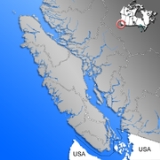
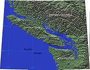
Vancouver Island is located in the southwestern corner of the province of British Columbia. It is separated from the mainland of British Columbia by Johnstone StraitJohnstone Strait
Johnstone Strait is a channel along the north east coast of Vancouver Island in British Columbia, Canada. Opposite the Vancouver Island coast, running north to south, are Hanson Island, West Cracroft Island, the mainland British Columbia Coast, Hardwick Island, West Thurlow Island and East...
, and Queen Charlotte Strait
Queen Charlotte Strait
Queen Charlotte Strait is a strait between Vancouver Island and the mainland of British Columbia, Canada. It connects Queen Charlotte Sound with Johnstone Strait, Discovery Passage and then to the Strait of Georgia and Puget Sound...
on the northeast, and by the Strait of Georgia
Strait of Georgia
The Strait of Georgia or the Georgia Strait is a strait between Vancouver Island and the mainland coast of British Columbia, Canada. It is approximately long and varies in width from...
on the southeast, which along with the Strait of Juan de Fuca
Strait of Juan de Fuca
The Strait of Juan de Fuca is a large body of water about long that is the Salish Sea outlet to the Pacific Ocean...
along its southwest separate it from the United States
United States
The United States of America is a federal constitutional republic comprising fifty states and a federal district...
(the Straits of Georgia and Juan de Fuca are now officially also part of the Salish Sea
Salish Sea
The name Salish Sea was coined only in the late 20th century, and was officially recognized by the United States in 2009 and by Canada in 2010, to describe the coastal waterways surrounding southern Vancouver Island and Puget Sound between Canada and the United States of America...
, which includes Puget Sound
Puget Sound
Puget Sound is a sound in the U.S. state of Washington. It is a complex estuarine system of interconnected marine waterways and basins, with one major and one minor connection to the Strait of Juan de Fuca and the Pacific Ocean — Admiralty Inlet being the major connection and...
as well). West of the island is the open Pacific Ocean, while to its north is Queen Charlotte Sound.
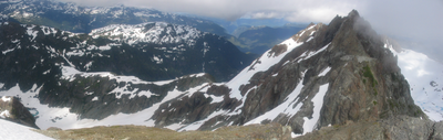
The Vancouver Island Ranges
Vancouver Island Ranges
The Vancouver Island Ranges, formerly called the Vancouver Island Mountains, is a mountain range extending along the length of Vancouver Island which has an area of 31,788 km² . The Vancouver Island Ranges comprise the central and largest part of the island...
run most of the length of the island, dividing it into a wet and rugged west coast and a drier, more rolling east coast. The highest point in these ranges and on the island is the Golden Hinde
Golden Hinde (British Columbia)
The Golden Hinde is a mountain located in the Vancouver Island Ranges on Vancouver Island, British Columbia, Canada. At , it is the highest peak on the island. The mountain is located near the centre of the Strathcona Provincial Park, at the head of the Wolf River and to the west of Buttle Lake,...
, at 2195 metres (7,201.4 ft). Located near the centre of Vancouver Island in 2500 square kilometres (965 sq mi) Strathcona Provincial Park
Strathcona Provincial Park
Strathcona Provincial Park is the oldest provincial park in British Columbia, Canada, and the largest on Vancouver Island. Founded in 1911, the park was named for Donald Alexander Smith, 1st Baron Strathcona and Mount Royal, a wealthy philanthropist and railroad pioneer. It lies within the...
, it is part of a group of peaks that include the only glaciers on the island, the largest of which is the Comox Glacier
Comox Glacier
The Comox Glacier is a glacier on Vancouver Island, British Columbia, Canada, located southwest of Courtenay and west of Argus Mountain.The highest elevation of the Comox Glacier, , refers to a rocky outcrop on the north side of the glacier...
. The west coast shoreline is rugged and in many places mountainous, characterised by its many fjords, bays, and inlets. The interior of the island has many lakes (Kennedy Lake
Kennedy Lake
Kennedy Lake is the largest lake on Vancouver Island, British Columbia, Canada. Located northeast of Ucluelet on the Island's central west coast, the lake is formed chiefly by the confluence of the Clayoquot and Kennedy Rivers. Outflow is via a short stretch of the Kennedy River into Tofino...
, northeast of Ucluelet, is the largest) and rivers.
Major centres
Vancouver Island's major population centre is the Capital Region, based around VictoriaVictoria, British Columbia
Victoria is the capital city of British Columbia, Canada and is located on the southern tip of Vancouver Island off Canada's Pacific coast. The city has a population of about 78,000 within the metropolitan area of Greater Victoria, which has a population of 360,063, the 15th most populous Canadian...
. There are six other metropolitan areas as defined by Statistics Canada
Statistics Canada
Statistics Canada is the Canadian federal government agency commissioned with producing statistics to help better understand Canada, its population, resources, economy, society, and culture. Its headquarters is in Ottawa....
. These metropolitan areas' populations in 2006 were as follows:
| Rank | Metropolitan Area | Population (2006 Census) | Core city |
|---|---|---|---|
| 1 | Capital Regional District | 330,088 | Victoria, BC |
| 2 | Greater Nanaimo | 92,361 | Nanaimo, BC |
| 3 | Comox Valley Comox Valley The Comox Valley is a region on the east coast of Vancouver Island, British Columbia, Canada that includes the city of Courtenay, the town of Comox, the village of Cumberland, and the unincorporated settlements of Royston, Union Bay, Fanny Bay, Black Creek and Merville. The communities of Denman... |
49,214 | Courtenay, BC |
| 4 | Cowichan Valley Cowichan Valley The Cowichan Valley is a region around the Cowichan River and Cowichan Lake on Vancouver Island, in British Columbia, Canada. There is some debate as to the origin of the name Cowichan, which many believe to be an anglicized form of the First Nations tribal name Quw'utsun.Communities include... |
41,387 | Duncan, BC |
| 5 | Campbell River | 36,461 | Campbell River, BC |
| 6 | Oceanside (Parksville-Qualicum Beach) | 26,518 | Parksville, BC |
| 7 | Alberni Valley Alberni Valley The Alberni Valley is located on Vancouver Island. Home to both Port Alberni, Sproat Lake and other outlining areas. The term is largely used as a synonym for Greater Port Alberni and adjoining communities but is used in a larger regional sense as well.... |
25,297 | Port Alberni, BC |
Climate
The climate is the mildest in Canada, with temperatures on the coast even in January being usually above 0 °C (32 °F). In summer, the warmest days usually achieve a maximum of 28–33 °C (82.4–91.4 F). However, the rain shadowRain shadow
A rain shadow is a dry area on the lee side of a mountainous area. The mountains block the passage of rain-producing weather systems, casting a "shadow" of dryness behind them. As shown by the diagram to the right, the warm moist air is "pulled" by the prevailing winds over a mountain...
effect of the island's mountains, as well as the mountains of Washington's Olympic Peninsula
Olympic Peninsula
The Olympic Peninsula is the large arm of land in western Washington state of the USA, that lies across Puget Sound from Seattle. It is bounded on the west by the Pacific Ocean, the north by the Strait of Juan de Fuca, and the east by Puget Sound. Cape Alava, the westernmost point in the contiguous...
, creates wide variation in precipitation. The west coast is considerably wetter than the east coast. Average annual precipitation ranges from 6650 millimetres (261.8 in) at Henderson Lake on the west coast (making it the wettest place in North America) to only 640 millimetres (25.2 in) at the driest recording station in the provincial capital of Victoria on the southeast coast's Saanich Peninsula
Saanich Peninsula
The Saanich Peninsula is located north of Victoria, British Columbia, Canada. It is bounded by the Saanich Inlet on the west, and various straits of the Gulf of Georgia on the east, chiefly Haro Strait The exact southern boundary of what is referred to as the "Saanich Peninsula" is somewhat fluid...
. Precipitation is heaviest in the autumn and winter. Snow is rare at low altitudes but is common on the island's mountaintops in winter.
A notable feature of Vancouver Island is the extension of summer dryness to latitudes as high as 50°N. Only in the extreme north of the island near Port Hardy
Port Hardy, British Columbia
Port Hardy is a district municipality in British Columbia, Canada located on the north-eastern coast of Vancouver Island. Port Hardy has a population of 3822 at last census...
is the rainfall of the driest summer month as much as one fifth that of the wettest months from November to March. West coasts of other continents at similar latitudes have a practically even distribution of rainfall through the year.
Geology
Volcanic rock
Volcanic rock is a rock formed from magma erupted from a volcano. In other words, it is an igneous rock of volcanic origin...
and sedimentary rock
Sedimentary rock
Sedimentary rock are types of rock that are formed by the deposition of material at the Earth's surface and within bodies of water. Sedimentation is the collective name for processes that cause mineral and/or organic particles to settle and accumulate or minerals to precipitate from a solution....
which was formed offshore on the now disappeared Kula
Kula Plate
The Kula Plate is an oceanic tectonic plate under the northern Pacific Ocean south of the Near Islands segment of the Aleutian Islands. It is subducting under the North American Plate at the Aleutian Trench and is surrounded by the Pacific Plate...
oceanic plate. Around 55 millions years ago, a microplate
Tectonic Plates
Tectonic Plates is a 1992 independent Canadian film directed by Peter Mettler. Mettler also wrote the screenplay based on the play by Robert Lepage. The film stars Marie Gignac, Céline Bonnier and Robert Lepage.-Plot summary:...
of the Kula Plate subducted
Subduction
In geology, subduction is the process that takes place at convergent boundaries by which one tectonic plate moves under another tectonic plate, sinking into the Earth's mantle, as the plates converge. These 3D regions of mantle downwellings are known as "Subduction Zones"...
below the North American
North American Plate
The North American Plate is a tectonic plate covering most of North America, Greenland, Cuba, Bahamas, and parts of Siberia, Japan and Iceland. It extends eastward to the Mid-Atlantic Ridge and westward to the Chersky Range in eastern Siberia. The plate includes both continental and oceanic crust...
continental margin
Continental margin
The continental margin is the zone of the ocean floor that separates the thin oceanic crust from thick continental crust. Continental margins constitute about 28% of the oceanic area....
with great strain. A volcanic arc
Volcanic arc
A volcanic arc is a chain of volcanoes positioned in an arc shape as seen from above. Offshore volcanoes form islands, resulting in a volcanic island arc. Generally they result from the subduction of an oceanic tectonic plate under another tectonic plate, and often parallel an oceanic trench...
on the surface of the Kula Plate was thus accreted
Accretion (geology)
Accretion is a process by which material is added to a tectonic plate or a landmass. This material may be sediment, volcanic arcs, seamounts or other igneous features.-Description:...
and fused onto the western edge of North America. These terrane
Terrane
A terrane in geology is short-hand term for a tectonostratigraphic terrane, which is a fragment of crustal material formed on, or broken off from, one tectonic plate and accreted or "sutured" to crust lying on another plate...
s were subjected to extreme warping from continued subduction of the Kula plate, leading to the formation of the distorted Insular Mountains
Insular Mountains
The Insular Mountains are a range of mountains in the Pacific Coast Ranges on the coast of British Columbia, Canada, comprising the Vancouver Island Ranges and Queen Charlotte Mountains. The Insular Mountains are rugged, particularly on Vancouver Island where peaks in Strathcona Provincial Park...
. Much of the central mountainous region around Strathcona Park
Strathcona Provincial Park
Strathcona Provincial Park is the oldest provincial park in British Columbia, Canada, and the largest on Vancouver Island. Founded in 1911, the park was named for Donald Alexander Smith, 1st Baron Strathcona and Mount Royal, a wealthy philanthropist and railroad pioneer. It lies within the...
is part of the Karmutsen Formation
Karmutsen Formation
The Karmutsen Formation is a Late Triassic volcanic sequence of tholeiitic pillow basalts and breccias on Vancouver Island, British Columbia, Canada. It is perhaps the thickest accreted section of an oceanic plateau worldwide, exposing up to 6000 m of basal sediment-sill complexes, basaltic to...
, which is a sequence of tholeiitic pillow basalt
Basalt
Basalt is a common extrusive volcanic rock. It is usually grey to black and fine-grained due to rapid cooling of lava at the surface of a planet. It may be porphyritic containing larger crystals in a fine matrix, or vesicular, or frothy scoria. Unweathered basalt is black or grey...
s and breccia
Breccia
Breccia is a rock composed of broken fragments of minerals or rock cemented together by a fine-grained matrix, that can be either similar to or different from the composition of the fragments....
s. Since Vancouver Island has become an accretionary wedge
Accretionary wedge
An accretionary wedge or accretionary prism is formed from sediments that are accreted onto the non-subducting tectonic plate at a convergent plate boundary...
on the North American continent, the Kula Plate has fully subducted beneath it and the remnants of the Farallon Plate
Farallon Plate
The Farallon Plate was an ancient oceanic plate, which began subducting under the west coast of the North American Plate— then located in modern Utah— as Pangaea broke apart during the Jurassic Period...
, the Juan de Fuca Plate
Juan de Fuca Plate
The Juan de Fuca Plate, named after the explorer of the same name, is a tectonic plate, generated from the Juan de Fuca Ridge, and subducting under the northerly portion of the western side of the North American Plate at the Cascadia subduction zone...
, are now subducting below the island. This process has led to Vancouver Island being one of the most seismically active regions in Canada. The subduction zone off the coast of the island forms a section of the Pacific Ring of Fire
Pacific Ring of Fire
The Pacific Ring of Fire is an area where large numbers of earthquakes and volcanic eruptions occur in the basin of the Pacific Ocean. In a horseshoe shape, it is associated with a nearly continuous series of oceanic trenches, volcanic arcs, and volcanic belts and/or plate movements...
. The area has been known to host megathrust earthquakes in the past, the last occurring in 1700. In 1946
1946 Vancouver Island earthquake
The 1946 Vancouver Island earthquake was a 7.3 magnitude earthquake that struck Vancouver Island, on the Coast of British Columbia, Canada, at 10:15 a.m. on Sunday, June 23, 1946. The main shock epicenter occurred in the Forbidden Plateau area northwest of Courtenay...
, the Forbidden Plateau
Forbidden Plateau
The Forbidden Plateau is a small, hilly plateau in the east of the Vancouver Island Ranges in British Columbia, located northwest of Comox Lake roughly between Mount Albert Edward to the southwest and Mount Washington to the northeast. The gently sloping sub-alpine terrain is broken by small,...
in the east of the Vancouver Island Ranges
Vancouver Island Ranges
The Vancouver Island Ranges, formerly called the Vancouver Island Mountains, is a mountain range extending along the length of Vancouver Island which has an area of 31,788 km² . The Vancouver Island Ranges comprise the central and largest part of the island...
was the epicenter
Epicenter
The epicenter or epicentre is the point on the Earth's surface that is directly above the hypocenter or focus, the point where an earthquake or underground explosion originates...
of an earthquake
Earthquake
An earthquake is the result of a sudden release of energy in the Earth's crust that creates seismic waves. The seismicity, seismism or seismic activity of an area refers to the frequency, type and size of earthquakes experienced over a period of time...
that registered 7.3 on the Richter scale, the strongest ever recorded on land in Canada.
Vancouver Island was the location of the observation of the episodic tremor and slip
Episodic tremor and slip (ETS)
Episodic tremor and slip is a phenomenon observed in seismology describing a particular type of tremor pattern observed in regions of convergent plate boundaries. These are characterised by non-earthquake-like tremors, accompanied by aseismic slip in the same region of the local megathrust...
seismic phenomenon.
Ecology
Vancouver Island lies in the temperate rainforest biomeBiome
Biomes are climatically and geographically defined as similar climatic conditions on the Earth, such as communities of plants, animals, and soil organisms, and are often referred to as ecosystems. Some parts of the earth have more or less the same kind of abiotic and biotic factors spread over a...
. On the southern and eastern portions of the island, this is characterized by Douglas-fir
Douglas-fir
Douglas-fir is one of the English common names for evergreen coniferous trees of the genus Pseudotsuga in the family Pinaceae. Other common names include Douglas tree, and Oregon pine. There are five species, two in western North America, one in Mexico, and two in eastern Asia...
, western red cedar, arbutus (or madrone), Garry oak
Garry Oak
Quercus garryana, the Garry Oak, Oregon White Oak or Oregon Oak, has a range from southern California to extreme southwestern British Columbia, particularly southeastern Vancouver Island and the adjacent Gulf Islands. It grows from sea level to 210 m altitude in the northern part of its range, and...
, salal
Salal
Gaultheria shallon is a leathery-leaved shrub in the heather family , native to western North America. In English it is known as salal, shallon, or in Britain simply Gaultheria.-Ecology:...
, Oregon-grape
Oregon-grape
Oregon-grape is an evergreen shrub related to the barberry. Some authors place Mahonia in the barberry genus, Berberis...
, and manzanita
Manzanita
Manzanita is a common name for many species of the genus Arctostaphylos. They are evergreen shrubs or small trees present in the chaparral biome of western North America, where they occur from southern British Columbia, Washington to California, Arizona and New Mexico in the United States, and...
; moreover, Vancouver Island is the location where the Douglas-fir was first recorded by Archibald Menzies
Archibald Menzies
Archibald Menzies was a Scottish surgeon, botanist and naturalist.- Life and career :Menzies was born at Easter Stix in the parish of Weem, in Perthshire. While working with his elder brother William at the Royal Botanic Gardens, he drew the attention of Dr John Hope, professor of botany at...
; Vancouver Island is also the location where some of the tallest Douglas fir were recorded. This southeastern portion of the island is the heavily populated region of Vancouver Island and a major area for recreation. The northern, western, and most of the central portions of the island are home to the coniferous "big trees" associated with British Columbia's coast — western hemlock
Tsuga
Tsuga is a genus of conifers in the family Pinaceae. The common name hemlock is derived from a perceived similarity in the smell of its crushed foliage to that of the unrelated plant poison hemlock....
, western red cedar, Pacific Silver Fir
Pacific Silver Fir
Abies amabilis, commonly known as the Pacific silver fir, is a fir native to the Pacific Northwest of North America, occurring in the Pacific Coast Ranges and the Cascade Range from the extreme southeast of Alaska, through western British Columbia, Washington and Oregon, to the extreme northwest of...
, yellow cedar, Douglas-fir
Douglas-fir
Douglas-fir is one of the English common names for evergreen coniferous trees of the genus Pseudotsuga in the family Pinaceae. Other common names include Douglas tree, and Oregon pine. There are five species, two in western North America, one in Mexico, and two in eastern Asia...
, grand fir
Grand Fir
Abies grandis is a fir native to the Pacific Northwest and Northern California of North America, occurring at altitudes of sea level to 1,800 m...
, Sitka spruce
Sitka Spruce
Picea sitchensis, the Sitka Spruce, is a large coniferous evergreen tree growing to 50–70 m tall, exceptionally to 95 m tall, and with a trunk diameter of up to 5 m, exceptionally to 6–7 m diameter...
, and western white pine
Western White Pine
Western White Pine, Pinus monticola in the family Pinaceae, is a species of pine that occurs in the mountains of the western United States and Canada, specifically the Sierra Nevada, the Cascade Range, the Coast Range, and the northern Rocky Mountains. The tree extends down to sea level in many...
. It is also characterised by bigleaf maple
Bigleaf Maple
Acer macrophyllum is a large deciduous tree in the genus Acer.It can grow to be up to 35 m tall, but more commonly grows 15 m to 20 m tall. It is native to western North America, mostly near the Pacific coast, from southernmost Alaska to southern California...
, red alder
Red Alder
Alnus rubra, the Red alder, is a deciduous broadleaf tree native to western North America.-Description:It is the largest species of alder in North America and one of the largest in the world, reaching heights of 20–35 m. The official tallest red alder stands 32 meters tall in Clatsop County, Oregon...
, sword fern, and red huckleberry
Vaccinium parvifolium
Red Huckleberry is a species of Vaccinium native to the western North America, where it is common in forests from southeastern Alaska and British Columbia south through western Washington and Oregon to central California. In the Oregon Coast Range, it is the most common Vaccinium...
.
The fauna of Vancouver Island is similar to that found on the mainland coast, with some notable exceptions and additions. For example, grizzly bear
Grizzly Bear
The grizzly bear , also known as the silvertip bear, the grizzly, or the North American brown bear, is a subspecies of brown bear that generally lives in the uplands of western North America...
s, mountain goat
Mountain goat
The Mountain Goat , also known as the Rocky Mountain Goat, is a large-hoofed mammal found only in North America. Despite its vernacular name, it is not a member of Capra, the genus of true goats...
s, porcupine
Porcupine
Porcupines are rodents with a coat of sharp spines, or quills, that defend or camouflage them from predators. They are indigenous to the Americas, southern Asia, and Africa. Porcupines are the third largest of the rodents, behind the capybara and the beaver. Most porcupines are about long, with...
s, moose
Moose
The moose or Eurasian elk is the largest extant species in the deer family. Moose are distinguished by the palmate antlers of the males; other members of the family have antlers with a dendritic configuration...
, skunk
Skunk
Skunks are mammals best known for their ability to secrete a liquid with a strong, foul odor. General appearance varies from species to species, from black-and-white to brown or cream colored. Skunks belong to the family Mephitidae and to the order Carnivora...
s, coyote
Coyote
The coyote , also known as the American jackal or the prairie wolf, is a species of canine found throughout North and Central America, ranging from Panama in the south, north through Mexico, the United States and Canada...
s, and numerous species of small mammals, while plentiful on the mainland, are absent from Vancouver Island. The island does support most of Canada's Roosevelt elk
Roosevelt elk
The Roosevelt elk , also known as Olympic elk, is the largest of the four surviving subspecies of elk in North America...
, however, and one species — the Vancouver Island Marmot
Vancouver Island Marmot
The Vancouver Island marmot naturally occurs only in the high mountains of Vancouver Island, in British Columbia, Canada. This particular marmot species is large compared to some other marmots, and most other rodents...
— is unique to the island. The island's rivers, lakes, and coastal regions are renowned for their fisheries
Fishery
Generally, a fishery is an entity engaged in raising or harvesting fish which is determined by some authority to be a fishery. According to the FAO, a fishery is typically defined in terms of the "people involved, species or type of fish, area of water or seabed, method of fishing, class of boats,...
of trout
Trout
Trout is the name for a number of species of freshwater and saltwater fish belonging to the Salmoninae subfamily of the family Salmonidae. Salmon belong to the same family as trout. Most salmon species spend almost all their lives in salt water...
, salmon
Salmon
Salmon is the common name for several species of fish in the family Salmonidae. Several other fish in the same family are called trout; the difference is often said to be that salmon migrate and trout are resident, but this distinction does not strictly hold true...
, and Steelhead
Rainbow trout
The rainbow trout is a species of salmonid native to tributaries of the Pacific Ocean in Asia and North America. The steelhead is a sea run rainbow trout usually returning to freshwater to spawn after 2 to 3 years at sea. In other words, rainbow trout and steelhead trout are the same species....
. It has the most concentrated population of cougars in North America.
After near-total extirpation by fur traders in the eighteenth and nineteenth centuries, Sea otter
Sea Otter
The sea otter is a marine mammal native to the coasts of the northern and eastern North Pacific Ocean. Adult sea otters typically weigh between 14 and 45 kg , making them the heaviest members of the weasel family, but among the smallest marine mammals...
s (Enhydra lutris) were protected by international treaty in 1911. Despite protection, the remnant population off Vancouver Island died out with the last sea otter taken near Kyuquot
Kyuquot, British Columbia
Kyuquot is an unincorporated settlement and First Nations Indian reserve community located on Kyuquot Sound on northwestern Vancouver Island, British Columbia, Canada. Meaning people of Kayukw in the Nuu-chah-nulth language, it is partly the community of the Kyuquot and Cheklesahht peoples, whose...
in 1929. From 1969 to 1972, 89 sea otters were flown or shipped from Alaska to the west coast of Vancouver Island. This population expanded to over 3,000 as of 2004, and their range on the island's west coast expanded from Cape Scott
Cape Scott Provincial Park
Cape Scott Provincial Park is a provincial park located at the cape of the same name, which is the northwestern tip of Vancouver Island, British Columbia, Canada. First established in 1973 with c. of area, later boundary revisions form an area of 22,290 ha...
in the north to Barkley Sound
Barkley Sound
Barkley Sound, also known historically as Barclay Sound, is south of Ucluelet and north of Bamfield on the west coast of Vancouver Island and forms the entrance to the Alberni Inlet...
to the south.
Technology
Within the island's largest city, Victoria, there is a significant IT and technology industry. According to the Victoria Advanced Technology Council website, over 800 technology companies operate in the Victoria area, with combined annual revenues of $1.95 billion.High Speed Internet is delivered to the island by Shaw Communications
Shaw Communications
Shaw Communications is Canada's largest telecommunications company that provides telephone, Canada's fastest Internet and television services as well as broadcasting and soon Wifi. Shaw is headquartered in Calgary, Alberta...
, Telus
TELUS
Telus is a national telecommunications company in Canada that provides a wide range of telecommunications products and services including internet access, voice, entertainment, video, and satellite television. The company is based in Burnaby, British Columbia, part of Greater Vancouver...
, and various local providers with their own networks. Wireless Internet connections can be found all over the Island, many free for public use.
While the Island does generate much of its own power at several hydroelectric stations, increased demand required the construction of several high voltage power cables, both HVDC and AC, connecting to the Canadian Mainland. See Powerlines connecting Vancouver Island with Canadian Mainland
Powerlines connecting Vancouver Island with Canadian Mainland
The power grid of Vancouver Island is connected with that of the Canadian Mainland by AC and DC submarine cables. It is according to all available information the only electricity grid on the Island, which is connected with the electricity grid of the mainland by AC and DC cables.These links, which...
.
Logging
Outside of Victoria, Vancouver Island's economy is largely dominated by the forestryForestry
Forestry is the interdisciplinary profession embracing the science, art, and craft of creating, managing, using, and conserving forests and associated resources in a sustainable manner to meet desired goals, needs, and values for human benefit. Forestry is practiced in plantations and natural stands...
industry. Many of the logging
Logging
Logging is the cutting, skidding, on-site processing, and loading of trees or logs onto trucks.In forestry, the term logging is sometimes used in a narrow sense concerning the logistics of moving wood from the stump to somewhere outside the forest, usually a sawmill or a lumber yard...
operations are for paper pulp, in "2nd growth" tree farm
Tree farm
A tree farm is a privately owned forest managed for timber production. The term tree farm is also used to refer to plantations and to tree nurseries.-American Tree Farm System:...
s that are harvested approximately every 30 years. Logging operations involving old-growth forest
Forest
A forest, also referred to as a wood or the woods, is an area with a high density of trees. As with cities, depending where you are in the world, what is considered a forest may vary significantly in size and have various classification according to how and what of the forest is composed...
s such as those found on Clayoquot Sound
Clayoquot Sound
Clayoquot Sound is located on the west coast of Vancouver Island in the Canadian province of British Columbia. It is bordered by the Esowista Peninsula to the south, and the Hesquiaht Peninsula to the North. It is a body of water with many inlets and islands. Major inlets include Sydney Inlet,...
are controversial and have gained international attention through the efforts of activists and environmental organizations.
Fishing
FishingFishing
Fishing is the activity of trying to catch wild fish. Fish are normally caught in the wild. Techniques for catching fish include hand gathering, spearing, netting, angling and trapping....
plays a large role in the lives of many islanders. Commercial fishing vessels operate out of the island's ports and harbours, and coastal fish farms
Fish farming
Fish farming is the principal form of aquaculture, while other methods may fall under mariculture. Fish farming involves raising fish commercially in tanks or enclosures, usually for food. A facility that releases young fish into the wild for recreational fishing or to supplement a species'...
(controversially) produce many tons of Atlantic salmon yearly.
Tourism
In recent years the government of British Columbia has engaged in an advertisingAdvertising
Advertising is a form of communication used to persuade an audience to take some action with respect to products, ideas, or services. Most commonly, the desired result is to drive consumer behavior with respect to a commercial offering, although political and ideological advertising is also common...
program to draw more tourists to beach resorts such as Tofino
Tofino, British Columbia
Tofino is a district of about 1,650 residents on the west coast of Vancouver Island, in British Columbia, Canada, located at the western terminus of Highway 4, on the tip of the Esowista Peninsula, at the southern edge of Clayoquot Sound....
. Sport fishing, whale-watching, hiking, SCUBA diving
Scuba diving
Scuba diving is a form of underwater diving in which a diver uses a scuba set to breathe underwater....
, and skiing are just a few things for which tourists visit Vancouver Island. Visitors also come to see Victoria's nineteenth-century architecture, and the many villages which line the coast such as Cowichan Bay, Chemainus, and Qualicum Beach.
Education
Vancouver Island is home to a handful of universities, several trade-schools and colleges, hundreds of public schools, and a few dozen private schools (including MontessoriMontessori method
Montessori education is an educational approach developed by Italian physician and educator Maria Montessori. Montessori education is practiced in an estimated 20,000 schools worldwide, serving children from birth to eighteen years old.-Overview:...
and Waldorf schools).
Universities
- University of VictoriaUniversity of VictoriaThe University of Victoria, often referred to as UVic, is the second oldest public research university in British Columbia, Canada. It is a research intensive university located in Saanich and Oak Bay, about northeast of downtown Victoria. The University's annual enrollment is about 20,000 students...
- Vancouver Island University (formerly Malaspina University-College)
- Royal Roads UniversityRoyal Roads UniversityRoyal Roads University is a public university located in Colwood, Greater Victoria, British Columbia, that describes itself as "Canada's University for Working Professionals".-Overview:...
Public school districts
There are 11 school districts on Vancouver Island with several elementary, junior high, and high schools in each. Three school districts are in the Greater Victoria area and the other eight cover the rest of the island to the north. All public schooling falls under the jurisdiction of the British Columbia Ministry of Education.Private schools
- St. Michael's University SchoolSt. Michaels University SchoolSt. Michaels University School is a private day and boarding school in the municipality of Saanich, which is a suburb of Victoria, British Columbia, Canada. The school is currently under the direction of headmaster Robert Snowden...
, VictoriaGreater Victoria, British ColumbiaGreater Victoria is located in British Columbia, Canada, on the southern tip of Vancouver Island. It is a cultural rather than political entity, usually defined as the thirteen easternmost municipalities of the Capital Regional District on Vancouver Island but also includes adjoining areas and...
, with campuses in Oak BayOak Bay, British ColumbiaOak Bay is a municipality located on the southern tip of Vancouver Island, in the Canadian Province of British Columbia, Canada. A member municipality of the Capital Regional District, it is a community east of and adjacent to the City of Victoria...
and SaanichSaanichThe Saanich or W̱SÁNEĆ are indigenous nations from the north coast of the Olympic Peninsula in Washington, the Gulf and San Juan Islands, southern Vancouver Island and the southern edge of the Lower Mainland in British Columbia.*BOḰEĆEN – Pauquachin... - Glenlyon NorfolkGlenlyon Norfolk SchoolGlenlyon Norfolk School is an independent, co-ed, university preparatory school in Victoria, British Columbia. It was formed in 1986 with the amalgamation of Glenlyon School and Norfolk House. The school offers instruction from Junior Kindergarten to Grade 12, and teaches according to the...
, VictoriaVictoria, British ColumbiaVictoria is the capital city of British Columbia, Canada and is located on the southern tip of Vancouver Island off Canada's Pacific coast. The city has a population of about 78,000 within the metropolitan area of Greater Victoria, which has a population of 360,063, the 15th most populous Canadian... - St. Margaret's School, Victoria (limited to female students)
- Brentwood CollegeBrentwood College SchoolBrentwood College School is a co-educational boarding school that focuses on preparing students for the challenges of post-secondary education. This school is located on Vancouver Island in Mill Bay, British Columbia, Canada.- Historical Overview :...
, Mill Bay - Shawnigan LakeShawnigan Lake SchoolShawnigan Lake School is a private boarding school, located in Shawnigan Lake, British Columbia, Canada. It was founded by Englishman, Christopher Windley 'C. W.' Lonsdale in 1916, and partly modelled on one of England's leading private schools, Westminster School.- Location :Shawnigan Lake School...
- Queen Margaret's SchoolQueen Margaret's SchoolQueen Margaret's School is a private boarding school/Day School, located in Duncan, British Columbia, Canada. It was founded by Miss Norah Creina Denny and Miss Dorothy Rachel Geoghegan in 1921...
, DuncanDuncan, British ColumbiaDuncan is a city on southern Vancouver Island in British Columbia, Canada.-History:The community is named after William Chalmers Duncan . He arrived in Victoria in May 1862, then in August of that year he was one of the party of a hundred settlers which Governor Douglas took to Cowichan Bay... - Dwight International School, Shawnigan LakeShawnigan Lake, British ColumbiaShawnigan Lake is a village on British Columbia's Vancouver Island. The name Shawnigan is an adaptation of the Hunquminum name for the Shawnigan Lake, the lake the village is situated at, Shaanii'us...
- Sunrise Waldorf School, DuncanDuncan, British ColumbiaDuncan is a city on southern Vancouver Island in British Columbia, Canada.-History:The community is named after William Chalmers Duncan . He arrived in Victoria in May 1862, then in August of that year he was one of the party of a hundred settlers which Governor Douglas took to Cowichan Bay...
- Island Oak High School, DuncanDuncan, British ColumbiaDuncan is a city on southern Vancouver Island in British Columbia, Canada.-History:The community is named after William Chalmers Duncan . He arrived in Victoria in May 1862, then in August of that year he was one of the party of a hundred settlers which Governor Douglas took to Cowichan Bay...
- Maria Montessori Academy, Victoria British Columbia, located in Gordan Head
- Lester B. Pearson College of the Pacific, MetchosinMetchosin, British ColumbiaThe District of Metchosin is a small, coastal community in the metro Greater Victoria region of British Columbia. It is part of the Western Communities and one of the 13 regional municipalities. Many Metchosinites are small farmers . Most are retired or work outside the community...
- St. Joseph's Chemainus Catholic Elementary School, ChemainusChemainus, British ColumbiaChemainus is a community on the east coast of Vancouver Island, British Columbia, Canada.Founded as a logging town in 1858, the town is now famous for its 39 outdoor murals. This outdoor gallery has given birth to 300 businesses, including a theatre, antiques dealers, and eateries. The tourist...
Sea
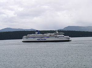
Marine transport is very important to Vancouver Island for access to the mainland of British Columbia and Washington. There are no bridges connecting the island to the mainland, although the idea of building one has been brought up many times. The only vehicle access to Vancouver Island is via ferries operated by BC FerriesBC Ferries
British Columbia Ferry Services Inc. or BC Ferries is a de facto Crown Corporation that provides all major passenger and vehicle ferry services for coastal and island communities in the Canadian province of British Columbia...
, Washington State Ferries
Washington State Ferries
Washington State Ferries is a passenger and automobile ferry service owned and operated by the Washington State Department of Transportation that serves communities on Puget Sound and in the San Juan Islands. It is the most used ferry system in the world and the largest passenger and automobile...
and Black Ball Transport Inc. There are seven vehicle ferry routes:
- TsawwassenTsawwassen, British ColumbiaTsawwassen is a suburban, mostly residential community located on a peninsula in the southwestern corner of the Corporation of Delta, British Columbia, Canada. Tsawwassen provides the only road access to the community of Point Roberts, Washington via 56th Street...
(38 km (24 mi) south of Vancouver) - Swartz BaySwartz Bay, British ColumbiaSwartz Bay, located on the north end of the Saanich Peninsula on Vancouver Island, is primarily known for being the location of one of BC Ferries' main terminals, the Swartz Bay Ferry Terminal. Swartz Bay was named after a man named Swart - i.e. it was meant to be Swart's Bay.-External links:...
(32 km (20 mi) north of Victoria)
- Crossing time: 1 hour 35 minutes; 8 sailings per day in the fall, winter, and spring and more in summer)
- TsawwassenTsawwassen, British ColumbiaTsawwassen is a suburban, mostly residential community located on a peninsula in the southwestern corner of the Corporation of Delta, British Columbia, Canada. Tsawwassen provides the only road access to the community of Point Roberts, Washington via 56th Street...
- Duke PointDuke Point, British ColumbiaDuke Point is a geographical location in the extreme southeastern part of the city of Nanaimo in British Columbia. It is located on a thin peninsula to the east of the Nanaimo River estuary, just across the Northumberland Channel from Gabriola Island. Located at Duke Point is a major industrial...
(13 km (8 mi) south of Nanaimo)
- Tsawwassen
- Crossing time: 2 hours; 8 round trips daily.
- Horseshoe Bay (19 km (12 mi) northwest of Vancouver) - Departure BayDeparture Bay, British ColumbiaDeparture Bay is a bay in central Nanaimo, British Columbia, on the east coast of Vancouver Island. The surrounding neighbourhood is also referred to as "Departure Bay"—once a settlement of its own, it was amalgamated into the City of Nanaimo in the 1970s .- Geography :The bay is framed to the...
(3 km (2 mi) north of downtown Nanaimo)
- Horseshoe Bay (19 km (12 mi) northwest of Vancouver) - Departure Bay
- Crossing time: 1 hour 35 minutes; Sailings every 2 hours with extra sailings during the summer and holidays.
- Gulf Islands - Swartz BaySwartz Bay, British ColumbiaSwartz Bay, located on the north end of the Saanich Peninsula on Vancouver Island, is primarily known for being the location of one of BC Ferries' main terminals, the Swartz Bay Ferry Terminal. Swartz Bay was named after a man named Swart - i.e. it was meant to be Swart's Bay.-External links:...
- Gulf Islands - Swartz Bay
- Crossing time: 35 minutes- 3 hours depending on island of departure; 4 or more trips daily.
- Powell RiverPowell River, British ColumbiaPowell River is a city on the northern Sunshine Coast of southwestern British Columbia, Canada. Most of its population lives near the eastern shores of Malaspina Strait, that part of the larger Georgia Strait between Texada Island and the Mainland...
- ComoxComox, British ColumbiaComox is a town of 12,000 people located on a small peninsula in the Georgia Strait on the eastern coast of Vancouver Island, British Columbia. The warm dry summers, mild winters, fertile soil and abundant sea life attracted First Nations thousands of years ago, who called the area kw’umuxws...
- Powell River
- Crossing time: 1 hour 20 minutes; 4 round trips daily.
- Port HardyPort Hardy, British ColumbiaPort Hardy is a district municipality in British Columbia, Canada located on the north-eastern coast of Vancouver Island. Port Hardy has a population of 3822 at last census...
- Prince RupertPrince Rupert, British ColumbiaPrince Rupert is a port city in the province of British Columbia, Canada. It is the land, air, and water transportation hub of British Columbia's North Coast, and home to some 12,815 people .-History:...
- Port Hardy
- Service daily or on alternate days; changes seasonally.
Washington State Ferries
- Anacortes, WashingtonAnacortes, WashingtonAnacortes is a city in Skagit County, Washington, United States. The name "Anacortes" is a consolidation of the name Anna Curtis, who was the wife of early Fidalgo Island settler Amos Bowman. Anacortes' population was 15,778 at the time of the 2010 census...
- SidneySidney, British ColumbiaSidney is a town located at the northern end of the Saanich Peninsula, on Vancouver Island in the Canadian province of British Columbia. It is one of the 13 Greater Victoria municipalities. It has a population of approximately 11,300. Sidney is located just east of Victoria International Airport,...
- Crossing time: 2 hours (not counting stops in the San Juan IslandsSan Juan IslandsThe San Juan Islands are an archipelago in the northwest corner of the contiguous United States between the US mainland and Vancouver Island, British Columbia, Canada. The San Juan Islands are part of the U.S...
)
Black Ball Transport
- Port Angeles, WashingtonPort Angeles, WashingtonPort Angeles is a city in and the county seat of Clallam County, Washington, United States. The population was 19,038 at the 2010 census. The area's harbor was dubbed Puerto de Nuestra Señora de los Ángeles by Spanish explorer Francisco de Eliza in 1791, but by the mid-19th century the name had...
- Victoria
- Crossing time: 1 hour 30 minutes; 1 or 2 round trips daily
Passenger-only service
In addition, there are three passenger-only ferry services from the mainland to Vancouver Island:
- Victoria ClipperVictoria ClipperClipper Navigation, Inc. is a privately held company based in Seattle, Washington that provides multiple transportation and vacation packages, many of which are offered under the name Clipper Vacations....
(Seattle, Washington - Victoria)
- Crossing time: 2 hour 45 minutes; 1 to 3 round trips daily
- Victoria Express (Port Angeles, Washington - Victoria)
- Crossing time: 1 hour (operates May through September)
- Victoria San Juan Cruises (Bellingham, WashingtonBellingham, WashingtonBellingham is the largest city in, and the county seat of, Whatcom County in the U.S. state of Washington. It is the twelfth-largest city in the state. Situated on Bellingham Bay, Bellingham is protected by Lummi Island, Portage Island, and the Lummi Peninsula, and opens onto the Strait of Georgia...
- Victoria)
- Victoria San Juan Cruises (Bellingham, Washington
- Crossing time: 3 hours (operates one trip per day May through October)
- In the past, several passenger catamaranCatamaranA catamaran is a type of multihulled boat or ship consisting of two hulls, or vakas, joined by some structure, the most basic being a frame, formed of akas...
s have been run between Nanaimo and Vancouver (most recently by HarbourLynxHarbourLynxHarbourLynx was a private company based in Nanaimo, British Columbia that provided passenger-only high speed ferry service between the city centres of Nanaimo and Vancouver....
). Despite the operations repeatedly going bankrupt, there is still popular interest in a passenger service between Nanaimo and Vancouver.
- In the past, several passenger catamaran
Rail
There are two remaining major railways on Vancouver Island.The Southern Railway of Vancouver Island, which assumed control of the Esquimalt and Nanaimo Railway from RailAmerica
RailAmerica
RailAmerica, Inc., based in Jacksonville, Florida, is a holding company of a number of short-line railroads and regional railroads in the United States and Canada....
in July 2006 offers general freight service on the Victoria–Courtenay main line (called the Victoria Subdivision by the railroad). The Port Alberni branch line (called the Port Alberni Subdivision by the railroad) has been out of service since late 2001.
SVI also runs passenger service under contract with VIA Rail
VIA Rail
Via Rail Canada is an independent crown corporation offering intercity passenger rail services in Canada. It is headquartered near Montreal Central Station at 3 Place Ville-Marie in Montreal, Quebec....
. Western Forest Products
Western Forest Products
Western Forest Products Inc. is a Canadian lumber company based in Vancouver in British Columbia, Canada.-History:Doman Singh bought a sawmill near Duncan in 1905...
operates the Englewood Railway
Englewood Railway
Englewood Railway is a logging railroad on northern Vancouver Island, Canada. Headquartered in Woss, the line runs from Vernon Lake, through Woss, past Nimpkish Lake Provincial Park to Beaver Cove...
which is Canada's last logging railway, running from Woss
Woss, British Columbia
Woss, British Columbia, commonly known as Woss Lake, is a small west coast village in the Nimpkish Valley, located south east of Port McNeill, and north of Campbell River on Highway 19, in northern Vancouver Island...
to Beaver Cove on the northern end of the island. The former Canadian National Railway
Canadian National Railway
The Canadian National Railway Company is a Canadian Class I railway headquartered in Montreal, Quebec. CN's slogan is "North America's Railroad"....
out of Victoria to the Cowichan Valley was abandoned in the late 1980s/early 1990s, and the former grade between Victoria and Sooke is now the multi-use Galloping Goose Regional Trail. The BC Forest Discovery Centre
BC Forest Discovery Centre
The BC Forest Discovery Centre, located in Duncan, chronicles the history of logging in British Columbia, Canada. Its mission is to be British Columbia's foremost interpreter and presenter of the forest community – past, present and future. It is a 100 acre site with 3 km of operational...
has a narrow gauge railway winding around the park, and the Alberni Pacific Railway operates during the summer from the restored E&N Railway station in Port Alberni to the McLean's Mill on former E&N Railway trackage.
Road
There is one major north-south highway system on the island, which runs along the eastern side. It begins as Highway 1 in Victoria, and merges with Highway 19 in Nanaimo, which then terminates at Port HardyPort Hardy, British Columbia
Port Hardy is a district municipality in British Columbia, Canada located on the north-eastern coast of Vancouver Island. Port Hardy has a population of 3822 at last census...
. The highway is a four lane divided highway between Victoria and Campbell River (except the Malahat section), and two lanes north of Campbell River.
East-west routes are:
- Highway 4 between ParksvilleParksville, British Columbia-Demographics:Parksville had a population of 10,993 people in 2006, which was an increase of 6.5% from the 2001 census count. The median household income in 2006 for Parksville was $55,524, which is below the British Columbia provincial average of $62,346....
and TofinoTofino, British ColumbiaTofino is a district of about 1,650 residents on the west coast of Vancouver Island, in British Columbia, Canada, located at the western terminus of Highway 4, on the tip of the Esowista Peninsula, at the southern edge of Clayoquot Sound....
; - Highway 14 between Greater VictoriaGreater Victoria, British ColumbiaGreater Victoria is located in British Columbia, Canada, on the southern tip of Vancouver Island. It is a cultural rather than political entity, usually defined as the thirteen easternmost municipalities of the Capital Regional District on Vancouver Island but also includes adjoining areas and...
and Port RenfrewPort Renfrew, British ColumbiaPort Renfrew is a community on the west coast of Vancouver Island, British Columbia, Canada, located approximately 2 hours' drive west of Victoria, British Columbia. Port Renfrew is the western terminus of the Juan de Fuca Trail. Tall Tree Music Festival also calls Port Renfrew home, proving to be...
; - Highway 18 between DuncanDuncan, British ColumbiaDuncan is a city on southern Vancouver Island in British Columbia, Canada.-History:The community is named after William Chalmers Duncan . He arrived in Victoria in May 1862, then in August of that year he was one of the party of a hundred settlers which Governor Douglas took to Cowichan Bay...
and Lake CowichanLake Cowichan, British ColumbiaCowichan Lake is a large freshwater lake located on southern Vancouver Island, British Columbia, Canada. It is located along the Cowichan Valley in the Cowichan Valley Regional District, with its eastern shore about west of Duncan, British Columbia. Cowichan Lake is about in length, running...
; - Highway 28 between Campbell RiverCampbell River, British ColumbiaCampbell River is a coastal city in British Columbia on the east coast of Vancouver Island at the south end of Discovery Passage, which lies along the important coastal Inside Passage shipping route...
and Gold RiverGold River, British ColumbiaGold River is a village located close to the geographic centre of Vancouver Island in British Columbia, Canada. In terms of the Island's human geography it is considered to be part of the "North Island", even though it technically is on the Island's west coast....
; and - Highway 30British Columbia Highway 30Highway 30, also known as Port Alice Road, is a 30 km-long northeast-to-southwest scenic route on northern Vancouver Island, connecting Port Alice with a location on Highway 19 known as Keogh, between Port Hardy and Port McNeill...
between Port HardyPort Hardy, British ColumbiaPort Hardy is a district municipality in British Columbia, Canada located on the north-eastern coast of Vancouver Island. Port Hardy has a population of 3822 at last census...
and Port AlicePort Alice, British ColumbiaPort Alice is a small, quiet, town of approx. 821 located off on Neroutsos Inlet, northwest of Port McNeill, on Vancouver Island, originally built by Whalen Pulp and Paper Mills of Vancouver. The community is known for its natural beauty, pulp mill, and salt water fishing.-History:It was named...
.
In addition, Highway 17 connects Victoria with the Saanich Peninsula, terminating the Vancouver Island portion of its route at the Swartz Bay Ferry Terminal
Swartz Bay Ferry Terminal
The Swartz Bay Ferry Terminal is a major transportation facility at Swartz Bay in North Saanich, British Columbia. It is located north of Victoria on Vancouver Island...
.
Vancouver Island is well served by secondary routes, and numerous active and decommissioned logging and forest service roads provide access into the back country.
Many communities are served by public transit. Greater Victoria is one of the few places in North America where double-deck buses are used in the regular public transit system.
Proposals have been made for a "fixed link" to the mainland for over a century. Because of the extreme depth and soft seabed of the Georgia Strait, and the potential for seismic activity, a bridge or tunnel would face monumental engineering, safety, and environmental challenges at a prohibitive cost.
Air
Victoria International AirportVictoria International Airport
Victoria International Airport serves Victoria, British Columbia, Canada. It is north northwest of the city, in North Saanich, quite close to the town of Sidney on the Saanich Peninsula...
(YYJ)
- Victoria Airport is the major airport on Vancouver Island. In 2010, it was the 9th busiest airport in Canada in terms of passenger movements (1,464,420). Six major carriers (Air CanadaAir CanadaAir Canada is the flag carrier and largest airline of Canada. The airline, founded in 1936, provides scheduled and charter air transport for passengers and cargo to 178 destinations worldwide. It is the world's tenth largest passenger airline by number of destinations, and the airline is a...
, Air Canada JazzAir Canada JazzJazz Aviation LP is a Canadian regional airline based at Halifax Stanfield International Airport in Enfield and Halifax Regional Municipality, Nova Scotia, and is a wholly owned subsidiary of Chorus Aviation....
, United AirlinesUnited AirlinesUnited Air Lines, Inc., is the world's largest airline with 86,852 employees United Air Lines, Inc., is the world's largest airline with 86,852 employees United Air Lines, Inc., is the world's largest airline with 86,852 employees (which includes the entire holding company United Continental...
, Horizon AirHorizon AirHorizon Air Industries, Inc. is a regional low-cost airline based in SeaTac, Washington, United States. It is the eighth largest regional airline in the USA, serving 52 cities in the United States, Canada and Mexico....
, Pacific Coastal AirlinesPacific Coastal AirlinesPacific Coastal Airlines is an airline based in Richmond, British Columbia, Canada. It operates scheduled, charter and cargo services to destinations in British Columbia. Its main base is Vancouver International Airport, with a hub at Port Hardy Airport....
, and WestJetWestJetWestJet Airlines Ltd. is a Canadian low-cost carrier that provides scheduled and charter air service to 71 destinations in Canada, the United States, Mexico and the Caribbean. Founded in 1996, WestJet is currently the second largest Canadian air carrier, behind Air Canada, operating an average of...
) offer a variety of direct flights of short and medium distance including to and from Seattle, San Francisco, CalgaryCalgaryCalgary is a city in the Province of Alberta, Canada. It is located in the south of the province, in an area of foothills and prairie, approximately east of the front ranges of the Canadian Rockies...
, EdmontonEdmontonEdmonton is the capital of the Canadian province of Alberta and is the province's second-largest city. Edmonton is located on the North Saskatchewan River and is the centre of the Edmonton Capital Region, which is surrounded by the central region of the province.The city and its census...
, VancouverVancouverVancouver is a coastal seaport city on the mainland of British Columbia, Canada. It is the hub of Greater Vancouver, which, with over 2.3 million residents, is the third most populous metropolitan area in the country,...
, and TorontoTorontoToronto is the provincial capital of Ontario and the largest city in Canada. It is located in Southern Ontario on the northwestern shore of Lake Ontario. A relatively modern city, Toronto's history dates back to the late-18th century, when its land was first purchased by the British monarchy from...
. Victoria International also has seasonal service to Puerto VallartaPuerto VallartaPuerto Vallarta is a Mexican balneario resort city situated on the Pacific Ocean's Bahía de Banderas.The 2010 census reported Puerto Vallarta's population as 255,725 making it the sixth-largest city in the state of Jalisco...
, CancunCancúnCancún is a city of international tourism development certified by the UNWTO . Located on the northeast coast of Quintana Roo in southern Mexico, more than 1,700 km from Mexico City, the Project began operations in 1974 as Integrally Planned Center, a pioneer of FONATUR Cancún is a city of...
, Las VegasLas Vegas metropolitan areaThe Las Vegas Valley is the heart of the Las Vegas-Paradise, NV MSA also known as the Las Vegas–Paradise–Henderson MSA which includes all of Clark County, Nevada, and is a metropolitan area in the southern part of the U.S. state of Nevada. The Valley is defined by the Las Vegas Valley landform, a ...
, and Honolulu.
CFB Comox
CFB Comox
Canadian Forces Base Comox , commonly referred to as CFB Comox, is a Canadian Forces Base located north northeast of Comox, British Columbia. It is primarily operated as an air force base by the Royal Canadian Air Force and is one of two bases in the country using the CP-140 Aurora...
(YQQ)
- CFB Comox/Comox Valley Airport is a shared military and civilian airport. In 2010 the Comox Valley Airport was the second busiest airport on Vancouver Island in terms of passenger movements (291,910). It offers direct flights to Calgary, Edmonton, Vancouver, and Campbell River several times daily, as well as Puerto VallartaPuerto VallartaPuerto Vallarta is a Mexican balneario resort city situated on the Pacific Ocean's Bahía de Banderas.The 2010 census reported Puerto Vallarta's population as 255,725 making it the sixth-largest city in the state of Jalisco...
, MexicoMexicoThe United Mexican States , commonly known as Mexico , is a federal constitutional republic in North America. It is bordered on the north by the United States; on the south and west by the Pacific Ocean; on the southeast by Guatemala, Belize, and the Caribbean Sea; and on the east by the Gulf of...
, on a weekly basis through WestJet.
Nanaimo Airport
Nanaimo Airport
Nanaimo Airport, , is located south southeast of Nanaimo, British Columbia, Canada.The airport is classified as an airport of entry by NAV CANADA and is staffed by the Canada Border Services Agency...
(YCD)
- Nanaimo Airport has flights with Air Canada JazzAir Canada JazzJazz Aviation LP is a Canadian regional airline based at Halifax Stanfield International Airport in Enfield and Halifax Regional Municipality, Nova Scotia, and is a wholly owned subsidiary of Chorus Aviation....
to VancouverVancouverVancouver is a coastal seaport city on the mainland of British Columbia, Canada. It is the hub of Greater Vancouver, which, with over 2.3 million residents, is the third most populous metropolitan area in the country,...
and Island Express AirIsland Express AirIsland Express Air is a small Canadian airline based in Abbotsford, British Columbia. Its first flight was on August 7, 2009 as part of the Abbotsford International Airshow...
to Victoria and Abbotsford. A recently installed (as of February 2010) instrument landing system and runway extension has improved the capacity, safety, and punctuality of flights. There are more improvements slated for completion March 2011.
Tofino Airport
Tofino Airport
Tofino/Long Beach Airport, , is located southeast of Tofino, British Columbia, Canada.It is used by private and small commercial planes. Coastal fog is a common morning phenomenon in the summer, complicating access by air until the weather clears. Several IFR approaches are available including GPS...
(YAZ), Campbell River Airport
Campbell River Airport
Campbell River Airport is located south of the town of Campbell River, British Columbia, Canada.The airport is classified as an airport of entry by NAV CANADA and is staffed by the Canada Border Services Agency...
(YBL) and Port Hardy Airport
Port Hardy Airport
Port Hardy Airport, , is located southeast of Port Hardy, British Columbia, Canada.The airport is classified as an airport of entry by NAV CANADA and is staffed by the Canada Border Services Agency. CBSA officers at this airport currently can handle general aviation aircraft only, with no more...
(YZT)
- TofinoTofino, British ColumbiaTofino is a district of about 1,650 residents on the west coast of Vancouver Island, in British Columbia, Canada, located at the western terminus of Highway 4, on the tip of the Esowista Peninsula, at the southern edge of Clayoquot Sound....
, Campbell RiverCampbell River, British ColumbiaCampbell River is a coastal city in British Columbia on the east coast of Vancouver Island at the south end of Discovery Passage, which lies along the important coastal Inside Passage shipping route...
and Port HardyPort Hardy, British ColumbiaPort Hardy is a district municipality in British Columbia, Canada located on the north-eastern coast of Vancouver Island. Port Hardy has a population of 3822 at last census...
have small airports capable of handling private aircraft and small commercial jets.
Harbour Airports and Heliports
- FloatplaneFloatplaneA floatplane is a type of seaplane, with slender pontoons mounted under the fuselage; only the floats of a floatplane normally come into contact with water, with the fuselage remaining above water...
and helicopterHelicopterA helicopter is a type of rotorcraft in which lift and thrust are supplied by one or more engine-driven rotors. This allows the helicopter to take off and land vertically, to hover, and to fly forwards, backwards, and laterally...
traffic to and from Victoria's Inner HarbourVictoria Inner Harbour AirportVictoria Harbour Airport or Victoria Harbour Water Aerodrome, , is located in Victoria Harbour, adjacent to Victoria, British Columbia, Canada....
(YWH) accounted for 261,712 passengers in 2010, making it the third busiest airport on Vancouver Island. Nanaimo Harbour (ZNA) also operates a busy water aerodromeAerodromeAn aerodrome, airdrome or airfield is a term for any location from which aircraft flight operations take place, regardless of whether they involve cargo, passengers or neither...
. Much of the floatplane traffic is downtown-to-downtown service between these two and Vancouver Harbour, the primary carriers being Harbour AirHarbour AirHarbour Air is a scheduled service, tour and charter airline based in Richmond, British Columbia, Canada. The airline specializes in routes between Vancouver, Nanaimo, Victoria, Sechelt, Comox and the Gulf Islands, primarily with de Havilland Canada floatplanes...
, West Coast AirWest Coast AirWest Coast Air is a scheduled airline operating de Havilland Canada float planes, with scheduled flights from downtown Vancouver and the Richmond Floatplane base at Vancouver International Airport to Victoria, Nanaimo, Comox, the Sunshine Coast, and Whistler. The company also flies tours and...
, and Baxter AviationBaxter AviationBaxter Aviation was an airline based in Nanaimo, British Columbia, Canada, founded by Tom and Linda Baxter which operated scheduled and chartered services throughout the Pacific Northwest with DHC-2 Beaver float-equipped aircraft...
. Harbour Air also flies to other areas around Vancouver, service to Seattle's Lake Union is provided by Kenmore AirKenmore AirKenmore Air Harbor, Inc., doing business as Kenmore Air, is an American airline with its headquarters on the grounds of Kenmore Air Harbor in Kenmore, Washington, USA, north of Seattle...
, and Orca AirwaysOrca AirwaysOrca Airways is a scheduled and charter airline based in Vancouver, British Columbia, Canada. Orca operates a fleet of 15 Piper Navajo aircraft from the south terminal at Vancouver International Airport.-History:...
runs flights between Vancouver and Tofino HarbourTofino Harbour Water AerodromeTofino Harbour Water Aerodrome, , is located adjacent to Tofino Harbour, British Columbia, Canada....
. These carriers make several daily scheduled flights, weather permitting. Helicopter service is provided by HelijetHeliJetHelijet International is a helicopter airline and charter service based in Vancouver, British Columbia, Canada. It operates scheduled services and has a charter division servicing the film, television, aerial tour and general charter markets, as well as air ambulance services...
in Victoria and various private operators elsewhere.
See also
- Canadian wineCanadian wineCanadian wine is produced in mainly southern British Columbia and southern Ontario. There is also a growing number of small scale producers of grapes and wine in southern Quebec and Nova Scotia. The two largest wine-producing regions in Canada are the Okanagan Valley of British Columbia and the...
- Cascadia subduction zoneCascadia subduction zoneThe Cascadia subduction zone is a subduction zone, a type of convergent plate boundary that stretches from northern Vancouver Island to northern California. It is a very long sloping fault that separates the Juan de Fuca and North America plates.New ocean floor is being created offshore of...
- Colony of Vancouver IslandColony of Vancouver IslandThe Colony of Vancouver Island , was a crown colony of British North America from 1849 to 1866, after which it was united with British Columbia. The united colony joined the Dominion of Canada through Confederation in 1871...
- Cougar AnnieCougar AnnieAda Annie Rae-Arthur, later Ada Annie Lawson but better known as Cougar Annie, was a pioneer who settled near Hesquiat Harbour at Boat Basin in Clayoquot Sound on the west coast of Vancouver Island, Canada....
- First Nations on Vancouver Island
- Kinsol TrestleKinsol TrestleThe Kinsol Trestle, also known as the Koksilah River Trestle, is a wooden railway trestle located on Vancouver Island north of Shawnigan Lake in the Canadian Province of British Columbia...
- Sasquatch
- Vancouver Island Health AuthorityVancouver Island Health AuthorityVancouver Island Health Authority is the publicly-funded health care provider in an area in the Canadian province of British Columbia. The region includes the communities of:* Vancouver Island* Gulf Islands* Johnstone Strait* Central Coast...
- West Coast of Vancouver Island Aquatic Management BoardWest Coast of Vancouver Island Aquatic Management BoardThe West Coast Vancouver Island Aquatic Management Board is one of Canada’s only co-management bodies for aquatic ecosystems. During the 1980s and 1990s, the federal government and coastal communities came to agree that a gap had to be closed; aquatic management decisions should start to include...
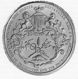