
International Date Line
Encyclopedia
180th meridian
The 180th meridian or antimeridian is the meridian which is 180° east or west of the Prime Meridian passing through the Royal Observatory, Greenwich. It is common to both east longitude and west longitude. It is used as the basis for the International Date Line because it for the most part passes...
longitude
Longitude
Longitude is a geographic coordinate that specifies the east-west position of a point on the Earth's surface. It is an angular measurement, usually expressed in degrees, minutes and seconds, and denoted by the Greek letter lambda ....
, opposite the Prime Meridian
Prime Meridian
The Prime Meridian is the meridian at which the longitude is defined to be 0°.The Prime Meridian and its opposite the 180th meridian , which the International Date Line generally follows, form a great circle that divides the Earth into the Eastern and Western Hemispheres.An international...
, but it is drawn with diversions to pass around some territories and island groups.
Crossing the IDL travelling east results in a day or 24 hours being subtracted, so that the traveller repeats the date to the west of the line. Crossing west results in a day being added, that is, the date is the eastern side date plus one calendar day. The line is necessary in order to have a fixed, albeit arbitrary, boundary on the globe where the calendar date advances.
Geography
For part of its length, the International Date Line follows the meridianMeridian (geography)
A meridian is an imaginary line on the Earth's surface from the North Pole to the South Pole that connects all locations along it with a given longitude. The position of a point along the meridian is given by its latitude. Each meridian is perpendicular to all circles of latitude...
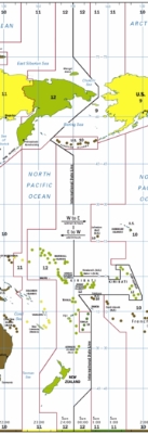
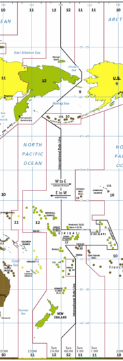
of 180° longitude, roughly down the middle of the Pacific Ocean. To avoid crossing nations internally the line deviates to pass around the far east of Russia and various island groups in the Pacific.
In the north, the date line swings to the east of Wrangel island
Wrangel Island
Wrangel Island is an island in the Arctic Ocean, between the Chukchi Sea and East Siberian Sea. Wrangel Island lies astride the 180° meridian. The International Date Line is displaced eastwards at this latitude to avoid the island as well as the Chukchi Peninsula on the Russian mainland...
and the Chukchi Peninsula
Chukchi Peninsula
The Chukchi Peninsula, Chukotka Peninsula or Chukotski Peninsula , at about 66° N 172° W, is the northeastern extremity of Asia. Its eastern end is at Cape Dezhnev near the village of Uelen. It is bordered by the Chukchi Sea to the north, the Bering Sea to the south, and the Bering Strait to the...
and through the Bering Strait
Bering Strait
The Bering Strait , known to natives as Imakpik, is a sea strait between Cape Dezhnev, Chukotka Autonomous Okrug, Russia, the easternmost point of the Asian continent and Cape Prince of Wales, Alaska, USA, the westernmost point of the North American continent, with latitude of about 65°40'N,...
passing between the Diomede Islands
Diomede Islands
The Diomede Islands , also known in Russia as Gvozdev Islands , consist of two rocky, tuya-like islands:* The U.S. island of Little Diomede or, in its native language, Ignaluk , and* The Russian island of Big Diomede , also known as Imaqliq,...
at a distance of 1.5 km (1 mi) from each island. It then goes southwest, passing west of St. Lawrence Island
St. Lawrence Island
St. Lawrence Island is located west of mainland Alaska in the Bering Sea, just south of the Bering Strait, at about 63°30' North 173°20' West. The village of Gambell is located on the northwest cape, from the Chukchi Peninsula in the Russian Far East. The island is part of Alaska, but closer to...
and St. Matthew Island
St. Matthew Island
St. Matthew Island is a remote island in the Bering Sea in Alaska, WNW of Nunivak Island. The island has a land area of , making it the 43rd largest island in the United States. Its most southerly point is Cape Upright which features cliff faces which exceed...
, until it passes midway between the United States' Aleutian Islands and Russia's Commander Islands before returning southeast to 180°. This keeps Russia
Russia
Russia or , officially known as both Russia and the Russian Federation , is a country in northern Eurasia. It is a federal semi-presidential republic, comprising 83 federal subjects...
which is north and west of the Bering Sea
Bering Sea
The Bering Sea is a marginal sea of the Pacific Ocean. It comprises a deep water basin, which then rises through a narrow slope into the shallower water above the continental shelves....
and the United States' Alaska
Alaska
Alaska is the largest state in the United States by area. It is situated in the northwest extremity of the North American continent, with Canada to the east, the Arctic Ocean to the north, and the Pacific Ocean to the west and south, with Russia further west across the Bering Strait...
which is east and south of the Bering Sea, on opposite sides of the line in agreement with the date in the rest of those countries.
Two uninhabited atolls, Howland Island
Howland Island
Howland Island is an uninhabited coral island located just north of the equator in the central Pacific Ocean, about southwest of Honolulu. The island lies almost halfway between Hawaii and Australia and is an unincorporated, unorganized territory of the United States. Geographically, it is part...
and Baker Island
Baker Island
Baker Island is an uninhabited atoll located just north of the equator in the central Pacific Ocean about southwest of Honolulu. The island lies almost halfway between Hawaii and Australia, and is a possession of the United States. Its nearest neighbor is Howland Island, to the north.Located at...
, just north of the equator in the central Pacific Ocean, have the latest time on Earth of UTC−12:00 hours, along with ships at sea between 172.5°W and 180°. The date line then circumscribes the country of Kiribati
Kiribati
Kiribati , officially the Republic of Kiribati, is an island nation located in the central tropical Pacific Ocean. The permanent population exceeds just over 100,000 , and is composed of 32 atolls and one raised coral island, dispersed over 3.5 million square kilometres, straddling the...
by swinging far to the east, almost reaching the 150° meridian
150th meridian west
The meridian 150° west of Greenwich is a line of longitude that extends from the North Pole across the Arctic Ocean, North America, the Pacific Ocean, the Southern Ocean, and Antarctica to the South Pole....
. Kiribati's easternmost islands, the southern Line Islands
Line Islands
The Line Islands, Teraina Islands or Equatorial Islands, is a chain of eleven atolls and low coral islands in the central Pacific Ocean, south of the Hawaiian Islands, that stretches for 2,350 km in a northwest-southeast direction, making it one of the longest islands chains of the world...
south of Hawaii
Hawaii
Hawaii is the newest of the 50 U.S. states , and is the only U.S. state made up entirely of islands. It is the northernmost island group in Polynesia, occupying most of an archipelago in the central Pacific Ocean, southwest of the continental United States, southeast of Japan, and northeast of...
, have the most advanced time on Earth of UTC+14
UTC+14
UTC+14 is an identifier for a +14 hour time offset from UTC. This is the highest time zone, meaning that areas in this zone are the first to see a new day, and therefore the first to celebrate a new year....
hours. In the South Pacific, the date line also lies east of 180°, so that Wallis and Futuna
Wallis and Futuna
Wallis and Futuna, officially the Territory of the Wallis and Futuna Islands , is a Polynesian French island territory in the South Pacific between Tuvalu to the northwest, Rotuma of Fiji to the west, the main part of Fiji to the southwest, Tonga to the southeast,...
, Fiji
Fiji
Fiji , officially the Republic of Fiji , is an island nation in Melanesia in the South Pacific Ocean about northeast of New Zealand's North Island...
, Tonga
Tonga
Tonga, officially the Kingdom of Tonga , is a state and an archipelago in the South Pacific Ocean, comprising 176 islands scattered over of ocean in the South Pacific...
, and New Zealand's Kermadec Islands
Kermadec Islands
The Kermadec Islands are a subtropical island arc in the South Pacific Ocean northeast of New Zealand's North Island, and a similar distance southwest of Tonga...
and Chatham Islands
Chatham Islands
The Chatham Islands are an archipelago and New Zealand territory in the Pacific Ocean consisting of about ten islands within a radius, the largest of which are Chatham Island and Pitt Island. Their name in the indigenous language, Moriori, means Misty Sun...
have the same date, but American Samoa
American Samoa
American Samoa is an unincorporated territory of the United States located in the South Pacific Ocean, southeast of the sovereign state of Samoa...
and New Zealand's Cook Islands
Cook Islands
The Cook Islands is a self-governing parliamentary democracy in the South Pacific Ocean in free association with New Zealand...
are one day earlier. As of the date line will be east of both Tokelau
Tokelau
Tokelau is a territory of New Zealand in the South Pacific Ocean that consists of three tropical coral atolls with a combined land area of 10 km2 and a population of approximately 1,400...
and Samoa
Samoa
Samoa , officially the Independent State of Samoa, formerly known as Western Samoa is a country encompassing the western part of the Samoan Islands in the South Pacific Ocean. It became independent from New Zealand in 1962. The two main islands of Samoa are Upolu and one of the biggest islands in...
(but west of American Samoa).
If one flies round the world from east to west (the same direction as Magellan
Ferdinand Magellan
Ferdinand Magellan was a Portuguese explorer. He was born in Sabrosa, in northern Portugal, and served King Charles I of Spain in search of a westward route to the "Spice Islands" ....
), one hour is lost for every 15° of longitude crossed, losing 24 hours for one circuit of the globe; one compensates by adding 24 hours when crossing the International Date Line (also from east to west). The International Date Line must therefore be observed in conjunction with the Earth's time zones: on crossing it, in either direction, the calendar date is adjusted by one day.
For two hours every day, between 10:00 and 11:59 (UTC), there are actually three different days observed at the same time in different places. At UTC time Thursday 10:15, for example, it is Wednesday 23:15 in American Samoa, which is eleven hours behind UTC, and it is Friday 00:15 in Kiritimati
Kiritimati
Kiritimati or Christmas Island is a Pacific Ocean raised coral atoll in the northern Line Islands, and part of the Republic of Kiribati....
(separated from American Samoa by the IDL), which is 14 hours ahead of UTC. For the first hour (UTC 10:00–10:59), this is true for inhabited territories, whereas during the second hour (UTC 11:00–11:59) it is only true if one counts an uninhabited maritime time zone twelve hours behind UTC.
De facto and de jure date lines
All nations unilaterally determine their standard time zoneTime zone
A time zone is a region on Earth that has a uniform standard time for legal, commercial, and social purposes. In order for the same clock time to always correspond to the same portion of the day as the Earth rotates , different places on the Earth need to have different clock times...
s, which are applicable only on land and adjacent territorial waters. These national zones do not extend into international waters. No international organization nor any treaty between nations has fixed the straight line segments and their junctions of the International Date Line drawn by cartographers. Indeed, the 1884 International Meridian Conference
International Meridian Conference
The International Meridian Conference was a conference held in October 1884 in Washington, D.C., in the United States to determine the Prime Meridian of the world. The conference was held at the request of U.S. President Chester A...
explicitly refused to propose or agree to any time zones, stating that they were outside its purview. The conference resolved that the Universal Day (midnight-to-midnight Greenwich Mean Time), which it did agree to, "shall not interfere with the use of local or standard time where desirable".
From this comes the utility and importance of UTC, or "Zulu" time: it permits a single and universal reference for time that is valid for all points on the globe at the same moment.
The nautical date line is a de jure
De jure
De jure is an expression that means "concerning law", as contrasted with de facto, which means "concerning fact".De jure = 'Legally', De facto = 'In fact'....
construction determined by international agreement. It is the result of the 1917 Anglo-French Conference on Time-keeping at Sea
Anglo-French Conference on Time-keeping at Sea
The Anglo-French Conference on Time-keeping at Sea was held in London in June 1917. The Conference established the nautical date line and adopted an ideal form of the terrestrial time zone system for use at sea. It recommended that time changes required by changes of longitude be made in one-hour...
, which recommended that all ships, both military and civilian, adopt hourly standard time zones on the high seas. The United States, for example, adopted its recommendation for U.S. military and merchant marine ships in 1920. This date line is implied but not explicitly drawn on time zone maps. It follows the 180° meridian
180th meridian
The 180th meridian or antimeridian is the meridian which is 180° east or west of the Prime Meridian passing through the Royal Observatory, Greenwich. It is common to both east longitude and west longitude. It is used as the basis for the International Date Line because it for the most part passes...
except where it is interrupted by territorial waters adjacent to land, forming gaps—it is a pole-to-pole dashed line. Ships should adopt the standard time of a country if they are within its territorial waters, but should revert to international time zones (15° wide pole-to-pole gore
Gore (segment)
A gore is a segment of a three-dimensional shape fabricated from a two-dimensional material. The term was originally used to describe triangular shapes, but is now extended to any shape that can be used to create the third dimension.-Examples:...
s) as soon as they leave its territorial waters. In reality they use these time zones only for purposes such as radio communication. For internal ship's purposes, e.g. for work and meal hours, passenger events and opening hours they use a time zone of their own choosing. The 15° gore that is offset from UTC by twelve hours is bisected by the nautical date line into two 7.5° gores that differ from UTC by ±12 hours.
The IDL drawn on the map on this page and all other maps is now and always has been an artificial construct of cartographers—the precise course of the cartogapher's line in international waters is arbitrary. Antarctic bases have determined their time, but they are so sparse around the IDL so its course is not determined. The IDL does not end at South pole, since there is a base there with a specified time (New Zealand time).
Historical alterations
The PhilippinesPhilippines
The Philippines , officially known as the Republic of the Philippines , is a country in Southeast Asia in the western Pacific Ocean. To its north across the Luzon Strait lies Taiwan. West across the South China Sea sits Vietnam...
, as part of the Viceroyalty of New Spain, long had its most important communication with Acapulco
Acapulco
Acapulco is a city, municipality and major sea port in the state of Guerrero on the Pacific coast of Mexico, southwest from Mexico City. Acapulco is located on a deep, semi-circular bay and has been a port since the early colonial period of Mexico’s history...
in Mexico, and was accordingly placed on the east side of the date line, despite being at the western edge of the Pacific Ocean. 00:01 Tuesday in London was 17:21 Monday in Acapulco and about 08:05 Monday in Manila
Manila
Manila is the capital of the Philippines. It is one of the sixteen cities forming Metro Manila.Manila is located on the eastern shores of Manila Bay and is bordered by Navotas and Caloocan to the north, Quezon City to the northeast, San Juan and Mandaluyong to the east, Makati on the southeast,...
. During the 1840s, trade interests turned to China, the Dutch East Indies
Dutch East Indies
The Dutch East Indies was a Dutch colony that became modern Indonesia following World War II. It was formed from the nationalised colonies of the Dutch East India Company, which came under the administration of the Netherlands government in 1800....
and adjacent areas, and the Philippines was changed to the west side of the date line. Monday, 30 December 1844 (ending up as a 365-day year, despite being a leap year) was followed by Wednesday, 1 January 1845.
Until 1867, Alaska
Alaska
Alaska is the largest state in the United States by area. It is situated in the northwest extremity of the North American continent, with Canada to the east, the Arctic Ocean to the north, and the Pacific Ocean to the west and south, with Russia further west across the Bering Strait...
began Russia's day, with the date line following the partially defined border between Russian Alaska
Russian Alaska
Russian America was the name of Russian colonial possessions in the Americas from 1733 to 1867 that today is the U.S. state of Alaska and settlements farther south in California and Hawaii...
and British North America
British North America
British North America is a historical term. It consisted of the colonies and territories of the British Empire in continental North America after the end of the American Revolutionary War and the recognition of American independence in 1783.At the start of the Revolutionary War in 1775 the British...
, including the colony of British Columbia
British Columbia
British Columbia is the westernmost of Canada's provinces and is known for its natural beauty, as reflected in its Latin motto, Splendor sine occasu . Its name was chosen by Queen Victoria in 1858...
. The day before the purchase
Alaska purchase
The Alaska Purchase was the acquisition of the Alaska territory by the United States from Russia in 1867 by a treaty ratified by the Senate. The purchase, made at the initiative of United States Secretary of State William H. Seward, gained of new United States territory...
by the United States took effect, it was Friday, , in the Julian calendar
Julian calendar
The Julian calendar began in 45 BC as a reform of the Roman calendar by Julius Caesar. It was chosen after consultation with the astronomer Sosigenes of Alexandria and was probably designed to approximate the tropical year .The Julian calendar has a regular year of 365 days divided into 12 months...
(used by Russia at the time), which would have been in the Gregorian calendar
Gregorian calendar
The Gregorian calendar, also known as the Western calendar, or Christian calendar, is the internationally accepted civil calendar. It was introduced by Pope Gregory XIII, after whom the calendar was named, by a decree signed on 24 February 1582, a papal bull known by its opening words Inter...
. The time in New Archangel would have been 12:00 when it was 12:02, Thursday, , at the future site of Whitehorse, Yukon
Whitehorse, Yukon
Whitehorse is Yukon's capital and largest city . It was incorporated in 1950 and is located at kilometre 1476 on the Alaska Highway in southern Yukon. Whitehorse's downtown and Riverdale areas occupy both shores of the Yukon River, which originates in British Columbia and meets the Bering Sea in...
, and 12:49, , at the future site of Vancouver, British Columbia
Vancouver
Vancouver is a coastal seaport city on the mainland of British Columbia, Canada. It is the hub of Greater Vancouver, which, with over 2.3 million residents, is the third most populous metropolitan area in the country,...
. With the transfer of governance, the date line was shifted (moving Alaska back a day), and the calendar was changed (moving Alaska ahead 12 days), and being effective at midnight the calendar moved ahead one day as well, for a net change of 12 days. Friday, , was followed by Friday, (not Saturday).
The Samoan Islands
Samoan Islands
The Samoan Islands or Samoa Islands is an archipelago covering in the central South Pacific, forming part of Polynesia and the wider region of Oceania...
were west of the date line until 1892, when King Malietoa Laupepa
Malietoa Laupepa
Susuga Malietoa Laupepa was the ruler of Samoa in the late 19th century.-Personal life: Laupepa was born in 1841 in Sapapali'i, Savaii, Samoa. His father was King Malietoa Moli and mother was Fa’alaituio Fuatino Su’a. He was raised in Malie, received a religious education at Malua Seminary and...
was persuaded by American traders to adopt the American date, being three hours behind California
California
California is a state located on the West Coast of the United States. It is by far the most populous U.S. state, and the third-largest by land area...
, to replace the former Asian date, being four hours ahead of Japan. The change was made by repeating Monday , American Independence Day
Independence Day (United States)
Independence Day, commonly known as the Fourth of July, is a federal holiday in the United States commemorating the adoption of the Declaration of Independence on July 4, 1776, declaring independence from the Kingdom of Great Britain...
. In 2011, 119 years after the first change was made, Samoa
Samoa
Samoa , officially the Independent State of Samoa, formerly known as Western Samoa is a country encompassing the western part of the Samoan Islands in the South Pacific Ocean. It became independent from New Zealand in 1962. The two main islands of Samoa are Upolu and one of the biggest islands in...
decided to shift back west of the date line by skipping Friday . Tokelau
Tokelau
Tokelau is a territory of New Zealand in the South Pacific Ocean that consists of three tropical coral atolls with a combined land area of 10 km2 and a population of approximately 1,400...
declared it would follow suit.
The central Pacific Republic of Kiribati
Kiribati
Kiribati , officially the Republic of Kiribati, is an island nation located in the central tropical Pacific Ocean. The permanent population exceeds just over 100,000 , and is composed of 32 atolls and one raised coral island, dispersed over 3.5 million square kilometres, straddling the...
introduced a change of date for its eastern half on , from time zones −11 and −10 to +13 and +14. Before this, the country was divided by the date line. After the change, the date line in effect moved eastwards to go around this country. As a British colony, Kiribati was centered in the Gilbert Islands
Gilbert Islands
The Gilbert Islands are a chain of sixteen atolls and coral islands in the Pacific Ocean. They are the main part of Republic of Kiribati and include Tarawa, the site of the country's capital and residence of almost half of the population.-Geography:The atolls and islands of the Gilbert Islands...
, just west of the old date line. Upon independence in 1979, the new republic acquired the Phoenix
Phoenix Islands
The Phoenix Islands are a group of eight atolls and two submerged coral reefs, lying in the central Pacific Ocean east of the Gilbert Islands and west of the Line Islands. They are a part of the Republic of Kiribati. During the late 1930s they became the site of the last attempted colonial...
and Line Islands
Line Islands
The Line Islands, Teraina Islands or Equatorial Islands, is a chain of eleven atolls and low coral islands in the central Pacific Ocean, south of the Hawaiian Islands, that stretches for 2,350 km in a northwest-southeast direction, making it one of the longest islands chains of the world...
from the United States and the country found itself straddling the date line. Government offices on opposite sides of the line could only communicate by radio or telephone on the four days of the week which were weekdays on both sides. As a consequence, Kiribati's easternmost territory, the Line Islands
Line Islands
The Line Islands, Teraina Islands or Equatorial Islands, is a chain of eleven atolls and low coral islands in the central Pacific Ocean, south of the Hawaiian Islands, that stretches for 2,350 km in a northwest-southeast direction, making it one of the longest islands chains of the world...
, including the inhabited Kiritimati
Kiritimati
Kiritimati or Christmas Island is a Pacific Ocean raised coral atoll in the northern Line Islands, and part of the Republic of Kiribati....
island, started the year 2000 before any other country on Earth, a feature the Kiribati government capitalized upon as a potential tourist draw. But it has been noted that the international community has not taken this date line adjustment very seriously, noticing that most world atlases still ignore the Kiribati dateline shift and continue to represent the International Date as a straight line in the Kiribati area.
Cultural references
The date line is a central factor in Umberto EcoUmberto Eco
Umberto Eco Knight Grand Cross is an Italian semiotician, essayist, philosopher, literary critic, and novelist, best known for his novel The Name of the Rose , an intellectual mystery combining semiotics in fiction, biblical analysis, medieval studies and literary theory...
's book The Island of the Day Before
The Island of the Day Before
The Island of the Day Before is a 1994 novel by Umberto Eco.It is the story of a 17th century Italian nobleman who is the only survivor of a shipwreck during a fierce storm. He finds himself washed up on an abandoned ship in a harbour through which, he convinces himself, runs the International...
, in which the protagonist finds himself on a becalmed ship, with an island close at hand on the other side of the International Date Line. Unable to swim, the protagonist's writings indulge in increasingly confused speculation of the physical, metaphysical and religious import of the date line.
Judaism
The concept of an international date line is first mentioned in a 12th-century Talmudic commentary which seems to indicate that the day changes in an area where the time is six hours ahead of Jerusalem (90 degrees east of Jerusalem, a line running through the PhilippinesPhilippines
The Philippines , officially known as the Republic of the Philippines , is a country in Southeast Asia in the western Pacific Ocean. To its north across the Luzon Strait lies Taiwan. West across the South China Sea sits Vietnam...
). This line, which he refers to as the K'tzai Hamizrach (the easternmost line), is used to calculate the day of Rosh Hashanah
Rosh Hashanah
Rosh Hashanah , , is the Jewish New Year. It is the first of the High Holy Days or Yamim Nora'im which occur in the autumn...
, the Jewish New Year. According to some sources it is alluded to in the Talmud (Rosh Hashanah and Eruvin) as well as in the Jerusalem Talmud.
The date line poses a problem for religious travellers relative to the day on which to observe the Shabbat
Shabbat
Shabbat is the seventh day of the Jewish week and a day of rest in Judaism. Shabbat is observed from a few minutes before sunset on Friday evening until a few minutes after when one would expect to be able to see three stars in the sky on Saturday night. The exact times, therefore, differ from...
and Holidays. The Shabbat is on the seventh day of the week, which is constant if one stays on the same side of the date line. The problem occurs when a Jewish traveller crosses the line and for whom it is Friday but for the city the traveller is visiting, it is Saturday. There are several different opinions regarding where exactly the date line is according to Jewish law.
The halachic ruling of Rabbi Moshe Heinemann
Moshe Heinemann
Rabbi Moshe Heinemann is an Orthodox rabbi and Posek who heads the Agudath Israel of Baltimore synagogue and is the rabbinical supervisor of the Star K kashrus certification agency...
Rabbinic Administrator of the Star-K
Star-K
Star-K Kosher Certification, also known as the Vaad Hakashrus of Baltimore, is a kashrus certifying agency based in Baltimore, Maryland under the administration of Rabbi Moshe Heinemann, with the involvement of many other rabbis . It is one of the largest kashrus certification agencies in North...
, is as follows: In New Zealand and Japan, the local Saturday is according to the majority opinion Shabbat, and it should therefore be fully observed as Shabbat, with Shabbat Prayers, etc. However, since according to the Chazon Ish, Shabbat is on the local Sunday, one should not perform any Shabbat Torah prohibitions on Sunday. Nevertheless, on Sunday, one should pray the regular weekday prayers, donning tefillin
Tefillin
Tefillin also called phylacteries are a set of small black leather boxes containing scrolls of parchment inscribed with verses from the Torah, which are worn by observant Jews during weekday morning prayers. Although "tefillin" is technically the plural form , it is loosely used as a singular as...
during morning prayers.
In Hawaii, Saturday is Shabbat according to the majority opinion. Therefore, the local Saturday is fully observed as Shabbat. The day known locally as Friday is Shabbat according to the minority opinion, and one should not perform Shabbat Torah prohibitions on that day. Cooking for Shabbat should therefore be done on Thursday.
Determining the majority opinion on the Aleutian Islands or South Pacific Islands, including Fiji and American Samoa, is complicated and beyond the scope of this article. However, in the following locations, Shabbat is observed on the local Saturday, and a second day is not necessary: Australia, China, Mainland Russia, Taiwan, Hong Kong, Mainland Alaska and Manila, and other areas of the Philippines west of 125.2°E.
Christianity
In Christianity it is also important to hold services on the correct day. Generally, the Christian calendar follows the legal calendar, and the Christian date line is on the same place as the international date line. One important issue exists in the Orthodox countries, where the Julian calendarJulian calendar
The Julian calendar began in 45 BC as a reform of the Roman calendar by Julius Caesar. It was chosen after consultation with the astronomer Sosigenes of Alexandria and was probably designed to approximate the tropical year .The Julian calendar has a regular year of 365 days divided into 12 months...
is followed for religious purposes but the Gregorian calendar
Gregorian calendar
The Gregorian calendar, also known as the Western calendar, or Christian calendar, is the internationally accepted civil calendar. It was introduced by Pope Gregory XIII, after whom the calendar was named, by a decree signed on 24 February 1582, a papal bull known by its opening words Inter...
for civilian purposes. The two calendars have the same weekdays, so the main issue is when to celebrate Easter, Christmas and other main holidays. In Tonga
Tonga
Tonga, officially the Kingdom of Tonga , is a state and an archipelago in the South Pacific Ocean, comprising 176 islands scattered over of ocean in the South Pacific...
, the Seventh Day Adventists
Seventh Day Adventist Church of Tonga
The Seventh Day Adventist Church of Tonga or Siasi ʻAhofitu is a church in Tonga. The Seventh-day Adventist used to worship on Saturday until the International Date Line was officially drawn to the west of Tonga. This changed the worship from Saturday to Sunday...
(who usually observe the sabbath
Sabbath
Sabbath in Christianity is a weekly day of rest or religious observance, derived from the Biblical Sabbath.Seventh-day Sabbath observance, i.e. resting from labor from Friday sunset to Saturday sunset, is practiced by seventh-day Sabbatarians...
on a Saturday) observe the sabbath on a Sunday, officially due to an anomaly in the International Date Line which makes Sunday really Saturday.