

Beaufort scale
Encyclopedia
Empirical
The word empirical denotes information gained by means of observation or experimentation. Empirical data are data produced by an experiment or observation....
measure that relates wind
Wind
Wind is the flow of gases on a large scale. On Earth, wind consists of the bulk movement of air. In outer space, solar wind is the movement of gases or charged particles from the sun through space, while planetary wind is the outgassing of light chemical elements from a planet's atmosphere into space...
speed
Wind speed
Wind speed, or wind velocity, is a fundamental atmospheric rate.Wind speed affects weather forecasting, aircraft and maritime operations, construction projects, growth and metabolism rate of many plant species, and countless other implications....
to observed conditions at sea or on land. Its full name is the Beaufort Wind Force Scale.
History
The scale was devised in 1805 by Sir Francis BeaufortFrancis Beaufort
Rear-Admiral Sir Francis Beaufort, FRS, FRGS was an Irish hydrographer and officer in Britain's Royal Navy...
, an Irish
Ireland
Ireland is an island to the northwest of continental Europe. It is the third-largest island in Europe and the twentieth-largest island on Earth...
-born Royal Navy Officer, while serving on HMS Woolwich
HMS Woolwich
Several ships of the Royal Navy have borne the name HMS Woolwich:, a 54-gun fourth rate ship of the line launched in 1675, rebuilt in 1702 and 1741, and broken up in 1747., a 44-gun fifth rate ship of the line launched in 1749, and sold in 1762., a 44-gun fifth rate, armed en flûte, launched in...
. The scale that carries Beaufort's name had a long and complex evolution, from the previous work of others, including Daniel Defoe
Daniel Defoe
Daniel Defoe , born Daniel Foe, was an English trader, writer, journalist, and pamphleteer, who gained fame for his novel Robinson Crusoe. Defoe is notable for being one of the earliest proponents of the novel, as he helped to popularise the form in Britain and along with others such as Richardson,...
the century before, to when Beaufort was a top administrator in the Royal Navy in the 1830s when it was adopted officially and first used during Darwin's
Charles Darwin
Charles Robert Darwin FRS was an English naturalist. He established that all species of life have descended over time from common ancestry, and proposed the scientific theory that this branching pattern of evolution resulted from a process that he called natural selection.He published his theory...
voyage on HMS Beagle
HMS Beagle
HMS Beagle was a Cherokee-class 10-gun brig-sloop of the Royal Navy. She was launched on 11 May 1820 from the Woolwich Dockyard on the River Thames, at a cost of £7,803. In July of that year she took part in a fleet review celebrating the coronation of King George IV of the United Kingdom in which...
. In the early 19th Century, naval officers made regular weather observations, but there was no standard scale and so they could be very subjective - one man's "stiff breeze" might be another's "soft breeze". Beaufort succeeded in standardizing the scale.
The initial scale of thirteen classes (zero to twelve) did not reference wind speed
Wind speed
Wind speed, or wind velocity, is a fundamental atmospheric rate.Wind speed affects weather forecasting, aircraft and maritime operations, construction projects, growth and metabolism rate of many plant species, and countless other implications....
numbers but related qualitative wind conditions to effects on the sails of a man-of-war, then the main ship of the Royal Navy
Royal Navy
The Royal Navy is the naval warfare service branch of the British Armed Forces. Founded in the 16th century, it is the oldest service branch and is known as the Senior Service...
, from "just sufficient to give steerage" to "that which no canvas sails could withstand."
At zero, all his sails would be up; at six, half of his sails would have been taken down; and at twelve, all sails would be stowed away.
The scale was made a standard for ship's log entries on Royal Navy vessels in the late 1830s and was adapted to non-naval use from the 1850s, with scale numbers corresponding to cup anemometer
Anemometer
An anemometer is a device for measuring wind speed, and is a common weather station instrument. The term is derived from the Greek word anemos, meaning wind, and is used to describe any airspeed measurement instrument used in meteorology or aerodynamics...
rotations. In 1916, to accommodate the growth of steam power, the descriptions were changed to how the sea, not the sails, behaved and extended to land observations. Rotations to scale numbers were standardized only in 1923. George Simpson
George Simpson (meteorologist)
Sir George Clarke Simpson KCB CBE FRS was a British meteorologist, born in Derby, England.-Biography:George Clarke Simpson was born 2 September 1878 in Derby England, the son of Arthur Simpson, a proprietor of a department store in East Street, and Alice Lambton Clarke...
, Director of the UK Meteorological Office, was responsible for this and for the addition of the land-based descriptors. The measure was slightly altered some decades later to improve its utility for meteorologists. Today, many countries have abandoned the scale and use the metric
Metric system
The metric system is an international decimalised system of measurement. France was first to adopt a metric system, in 1799, and a metric system is now the official system of measurement, used in almost every country in the world...
-based units m/s or km/h instead, but the severe weather
Severe weather
Severe weather phenomena are weather conditions that are hazardous to human life and property.- Examples Include :Severe weather can occur under a variety of situations, but three characteristics are generally needed: a temperature or moisture boundary, moisture, and , instability in the...
warnings given to public are still approximately the same as when using the Beaufort scale.
The Beaufort scale was extended in 1946, when Forces 13 to 17 were added. However, Forces 13 to 17 were intended to apply only to special cases, such as tropical cyclones. Nowadays, the extended scale is only used in Taiwan and mainland China, which are often affected by typhoons.
Wind speed on the 1946 Beaufort scale is based on the empirical formula
Empirical relationship
In science, an empirical relationship is one based solely on observation rather than theory. An empirical relationship requires only confirmatory data irrespective of theoretical basis. Sometimes theoretical explanations for what were initially empirical relationships are found, in which case the...
:
- v = 0.836 B3/2 m/s
where v is the equivalent wind speed at 10 metres above the sea surface and B is Beaufort scale number. For example, B = 9.5 is related to 24.5 m/s which is equal to the lower limit of "10 Beaufort". Using this formula the highest winds in hurricanes would be 23 in the scale.
Today, hurricane force winds are sometimes described as Beaufort scale 12 through 16, very roughly related to the respective category speeds of the Saffir-Simpson Hurricane Scale
Saffir-Simpson Hurricane Scale
The Saffir–Simpson Hurricane Scale , or the Saffir–Simpson Hurricane Wind Scale , classifies hurricanes — Western Hemisphere tropical cyclones that exceed the intensities of tropical depressions and tropical storms — into five categories distinguished by the intensities of their sustained winds...
, by which actual hurricanes are measured, where Category 1 is equivalent to Beaufort 12. However, the extended Beaufort numbers above 13 do not match the Saffir-Simpson Scale. Category 1 tornado
Tornado
A tornado is a violent, dangerous, rotating column of air that is in contact with both the surface of the earth and a cumulonimbus cloud or, in rare cases, the base of a cumulus cloud. They are often referred to as a twister or a cyclone, although the word cyclone is used in meteorology in a wider...
es on the Fujita
Fujita scale
The Fujita scale , or Fujita-Pearson scale, is a scale for rating tornado intensity, based primarily on the damage tornadoes inflict on human-built structures and vegetation...
and TORRO
TORRO scale
The TORRO tornado intensity scale is a scale measuring tornado intensity between T0 and T11. It was developed by Terence Meaden of the Tornado and Storm Research Organisation , a meteorological organisation in the United Kingdom, as an extension of the Beaufort scale.- History and derivation from...
scales also begin roughly at the end of level 12 of the Beaufort scale but are indeed independent scales.
Note that wave heights in the scale are for conditions in the open ocean
Ocean
An ocean is a major body of saline water, and a principal component of the hydrosphere. Approximately 71% of the Earth's surface is covered by ocean, a continuous body of water that is customarily divided into several principal oceans and smaller seas.More than half of this area is over 3,000...
, not along the shore.
The modern scale
| Beaufort number | Description | Wind speed | Wave height | | Sea conditions | 0 | Calm CALM CALM may refer to:*Campaign Against Living Miserably, UK charity aimed at bringing down the suicide rate among young men.*Café-Au-Lait Macules as seen in the medical condition neurofibromatosis... |
< 1 km/h (< 0.3 m/s) | 0 m Metre The metre , symbol m, is the base unit of length in the International System of Units . Originally intended to be one ten-millionth of the distance from the Earth's equator to the North Pole , its definition has been periodically refined to reflect growing knowledge of metrology... |
Flat. | Calm. Smoke rises vertically. |  |
|---|---|---|---|---|---|---|---|
| < 1 mph | |||||||
| < 1 kn | 0 ft | ||||||
| < 0.3 m/s Metre per second Metre per second is an SI derived unit of both speed and velocity , defined by distance in metres divided by time in seconds.... |
|||||||
| 1 | Light air Light air A light air is a wind of force 1 on the Beaufort Scale, ranging in strength from 1 to 3 knots. Wind of this strength may not be felt on the skin, and leaves vegetation essentially undisturbed. It induces a drift in columns of smoke. At sea, a light air will raise small ripples on the surface of the... |
1.1–5.5 km/h (0.3–2 m/s) | 0–0.2 m | Ripples without crests. | Smoke drift indicates wind direction and wind vanes cease moving. |  |
|
| 1–3 mph | |||||||
| 1–2 kn | 0–1 ft | ||||||
| 0.3–1.5 m/s | |||||||
| 2 | Light breeze Light breeze A light breeze is a wind of force 2 on the Beaufort Scale, ranging in strength from 4 to 6 knots. Winds of this strength can be felt on skin and can make small leaves and twigs rustle... |
5.6–11 km/h (2–3 m/s) | 0.2–0.5 m | Small wavelets. Crests of glassy appearance, not breaking | Wind felt on exposed skin. Leaves rustle and wind vanes begin to move. |  |
|
| 4–7 mph | |||||||
| 3–6 kn | 1–2 ft | ||||||
| 1.6–3.4 m/s | |||||||
| 3 | Gentle breeze | 12–19 km/h (3–5 m/s) | 0.5–1 m | Large wavelets. Crests begin to break; scattered whitecaps | Leaves and small twigs constantly moving, light flags extended. |  |
|
| 8–12 mph | |||||||
| 7–10 kn | 2–3.5 ft | ||||||
| 3.4–5.4 m/s | |||||||
| 4 | Moderate breeze | 20–28 km/h (6–8 m/s) | 1–2 m | Small waves with breaking crests. Fairly frequent whitecaps. | Dust and loose paper raised. Small branches begin to move. |  |
|
| 13–17 mph | |||||||
| 11–15 kn | 3.5–6 ft | ||||||
| 5.5–7.9 m/s | |||||||
| 5 | Fresh breeze | 29–38 km/h (8.1-10.6 m/s) | 2–3 m | Moderate waves of some length. Many whitecaps. Small amounts of spray. | Branches of a moderate size move. Small trees in leaf begin to sway. |  |
|
| 18–24 mph | |||||||
| 16–20 kn | 6–9 ft | ||||||
| 8.0–10.7 m/s | |||||||
| 6 | Strong breeze | 39–49 km/h (10.8-13.6 m/s) | 3–4 m | Long waves begin to form. White foam crests are very frequent. Some airborne spray is present. | Large branches in motion. Whistling heard in overhead wires. Umbrella use becomes difficult. Empty plastic garbage cans tip over. |  |
|
| 25–30 mph | |||||||
| 21–26 kn | 9–13 ft | ||||||
| 10.8–13.8 m/s | |||||||
| 7 | High wind, Moderate gale, Near gale |
50–61 km/h (13.9-16.9 m/s) | 4–5.5 m | Sea heaps up. Some foam from breaking waves is blown into streaks along wind direction. Moderate amounts of airborne spray. | Whole trees in motion. Effort needed to walk against the wind. |  |
|
| 31–38 mph | |||||||
| 27–33 kn | 13–19 ft | ||||||
| 13.9–17.1 m/s | |||||||
| 8 | Gale Gale A gale is a very strong wind. There are conflicting definitions of how strong a wind must be to be considered a gale. The U.S. government's National Weather Service defines a gale as 34–47 knots of sustained surface winds. Forecasters typically issue gale warnings when winds of this strength are... , Fresh gale |
62–74 km/h (17.2-20.6 m/s) | 5.5–7.5 m | Moderately high waves with breaking crests forming spindrift. Well-marked streaks of foam are blown along wind direction. Considerable airborne spray. | Some twigs broken from trees. Cars veer on road. Progress on foot is seriously impeded. |  |
|
| 39–46 mph | |||||||
| 34–40 kn | 18–25 ft | ||||||
| 17.2–20.7 m/s | |||||||
| 9 | Strong gale | 75–88 km/h (20.8-24.4 m/s) | 7–10 m | High waves whose crests sometimes roll over. Dense foam is blown along wind direction. Large amounts of airborne spray may begin to reduce visibility. | Some branches break off trees, and some small trees blow over. Construction/temporary signs and barricades blow over. |  |
|
| 47–54 mph | |||||||
| 41–47 kn | 23–32 ft | ||||||
| 20.8–24.4 m/s | |||||||
| 10 | Storm Storm A storm is any disturbed state of an astronomical body's atmosphere, especially affecting its surface, and strongly implying severe weather... , Whole gale |
89–102 km/h (24.7-28.3 m/s) | 9–12.5 m | Very high waves with overhanging crests. Large patches of foam from wave crests give the sea a white appearance. Considerable tumbling of waves with heavy impact. Large amounts of airborne spray reduce visibility. | Trees are broken off or uprooted, saplings bent and deformed. Poorly attached asphalt shingles and shingles in poor condition peel off roofs. |  |
|
| 55–63 mph | |||||||
| 48–55 kn | 29–41 ft | ||||||
| 24.5–28.4 m/s | |||||||
| 11 | Violent storm | 103–117 km/h (28.6-32.5 m/s) | 11.5–16 m | Exceptionally high waves. Very large patches of foam, driven before the wind, cover much of the sea surface. Very large amounts of airborne spray severely reduce visibility. | Widespread damage to vegetation. Many roofing surfaces are damaged; asphalt tiles that have curled up and/or fractured due to age may break away completely. |  |
|
| 64–72 mph | |||||||
| 56–63 kn | 37–52 ft | ||||||
| 28.5–32.6 m/s | |||||||
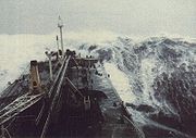
| 12 | Hurricane Force | ≥ 118 km/h (≥ 32.8 m/s) | ≥ 14 m | Huge waves. Sea is completely white with foam and spray. Air is filled with driving spray, greatly reducing visibility. | Very widespread damage to vegetation. Some windows may break; mobile homes and poorly constructed sheds and barns are damaged. Debris may be hurled about. |  |
|
| ≥ 73 mph | |||||||
| ≥ 64 kn | ≥ 46 ft | ||||||
| ≥ 32.7 m/s |
The scale is used in the Shipping Forecast
Shipping Forecast
The Shipping Forecast is a four-times-daily BBC Radio broadcast of weather reports and forecasts for the seas around the coasts of the British Isles. It is produced by the Met Office and broadcast by BBC Radio 4 on behalf of the Maritime and Coastguard Agency. The forecasts sent over the Navtex...
s broadcast on BBC Radio 4
BBC Radio 4
BBC Radio 4 is a British domestic radio station, operated and owned by the BBC, that broadcasts a wide variety of spoken-word programmes, including news, drama, comedy, science and history. It replaced the BBC Home Service in 1967. The station controller is currently Gwyneth Williams, and the...
in the United Kingdom
United Kingdom
The United Kingdom of Great Britain and Northern IrelandIn the United Kingdom and Dependencies, other languages have been officially recognised as legitimate autochthonous languages under the European Charter for Regional or Minority Languages...
, and in the Sea Area Forecast from Met Éireann
Met Éireann
Met Éireann is the national meteorological service in Ireland, part of the Department of the Environment, Heritage and Local Government.-History:...
, the Irish Meteorological Service. Met Éireann issues a "Small Craft Warning" if winds of Beaufort force 6 (mean wind speed exceeding 22 knots) are expected up to 10 nautical miles offshore. Other warnings are issued by Met Éireann for Irish coastal waters, which are regarded as extending 30 miles out from the coastline, and the Irish Sea or part thereof: "Gale Warnings" are issued if winds of Beaufort force 8 are expected; "Strong Gale Warnings" are issued if winds of Beaufort Force 9 or frequent gusts of at least 52 knots are expected.; "Storm Force Warnings" are issued if Beaufort force 10 or frequent gusts of at least 61 knots are expected; "Violent Storm Force Warnings" are issued if Beaufort force 11 or frequent gusts of at least 69 knots are expected; "Hurricane Force Warnings" are issued if winds of greater than 64 knots are expected.
This scale is also widely used in Greece
Greece
Greece , officially the Hellenic Republic , and historically Hellas or the Republic of Greece in English, is a country in southeastern Europe....
, China
China
Chinese civilization may refer to:* China for more general discussion of the country.* Chinese culture* Greater China, the transnational community of ethnic Chinese.* History of China* Sinosphere, the area historically affected by Chinese culture...
, Taiwan
Taiwan
Taiwan , also known, especially in the past, as Formosa , is the largest island of the same-named island group of East Asia in the western Pacific Ocean and located off the southeastern coast of mainland China. The island forms over 99% of the current territory of the Republic of China following...
, Hong Kong
Hong Kong
Hong Kong is one of two Special Administrative Regions of the People's Republic of China , the other being Macau. A city-state situated on China's south coast and enclosed by the Pearl River Delta and South China Sea, it is renowned for its expansive skyline and deep natural harbour...
and Macau
Macau
Macau , also spelled Macao , is, along with Hong Kong, one of the two special administrative regions of the People's Republic of China...
, however with some differences between them. Taiwan
Taiwan
Taiwan , also known, especially in the past, as Formosa , is the largest island of the same-named island group of East Asia in the western Pacific Ocean and located off the southeastern coast of mainland China. The island forms over 99% of the current territory of the Republic of China following...
uses the Beaufort scale with the extension to 17 noted above. China also switched to this extended version without prior notice on the morning of 15 May 2006, and the extended scale was immediately put to use for Typhoon Chanchu
Typhoon Chanchu
The name Chanchu has been used for two tropical cyclones in the western north Pacific Ocean. The name, submitted by Macau, means pearl.* 2000's Tropical Storm Chanchu - formed from the remnants of Tropical Storm Upana and mistakenly renamed, but not a threat to land.* 2006's Typhoon Chanchu -...
. Hong Kong
Hong Kong
Hong Kong is one of two Special Administrative Regions of the People's Republic of China , the other being Macau. A city-state situated on China's south coast and enclosed by the Pearl River Delta and South China Sea, it is renowned for its expansive skyline and deep natural harbour...
and Macau
Macau
Macau , also spelled Macao , is, along with Hong Kong, one of the two special administrative regions of the People's Republic of China...
however keep using Force 12 as the maximum.
In the United States
United States
The United States of America is a federal constitutional republic comprising fifty states and a federal district...
, winds of force 6 or 7 result in the issuance of a small craft advisory
Small craft advisory
A small craft advisory is a type of warning issued by the National Weather Service in the United States, most frequently in coastal areas. It is issued when winds have reached, or are expected to reach within 12 hours, a speed marginally less than gale force....
, with force 8 or 9 winds bringing about a gale warning
Gale warning
A gale warning is a warning issued by weather services in maritime locations about the existence of winds of gale force or above or the imminent occurrence of gales at sea...
, force 10 or 11 a storm warning
Storm warning
At sea, a storm warning is a warning issued by the National Weather Service of the United States when winds between 48 knots and 63 knots are occurring or predicted to occur soon. The winds must not be associated with a tropical cyclone...
("a tropical storm warning" being issued instead of the latter two if the winds relate to a tropical cyclone
Tropical cyclone
A tropical cyclone is a storm system characterized by a large low-pressure center and numerous thunderstorms that produce strong winds and heavy rain. Tropical cyclones strengthen when water evaporated from the ocean is released as the saturated air rises, resulting in condensation of water vapor...
), and force 12 a hurricane force wind warning
Storm warning
At sea, a storm warning is a warning issued by the National Weather Service of the United States when winds between 48 knots and 63 knots are occurring or predicted to occur soon. The winds must not be associated with a tropical cyclone...
(or hurricane warning if related to a tropical cyclone). A set of red warning flags (daylight) and red warning lights (night time) is displayed at shore establishments which coincide with the various levels of warning.
In Canada, maritime winds forecast to be in the range of 6 to 7 are designated as "strong"; 8 to 9 "gale force"; 10 to 11 "storm force"; 12 "hurricane force". Appropriate wind warnings are issued by Environment Canada's Meteorological Service of Canada: strong wind warning, gale (force wind) warning, storm (force wind) warning and hurricane force wind warning. These designations were standardized nationally in 2008, whereas "light wind" can refer to 0 to 12 or 0 to 15 knots and "moderate wind" 12 to 19 or 16 to 19 knots, depending on regional custom, definition or practice. Prior to 2008, a "strong wind warning" would have been referred to as a "small craft warning" by Environment Canada, similar to US terminology. (Canada and the USA have the Great Lakes in common.) However, there being no generally accepted definition of "small craft", and to have consistency between wind speed ranges and their associated warnings, the term "strong wind warning" has become the national Canadian norm.
See also
- American Practical Navigator
- Saffir-Simpson Hurricane ScaleSaffir-Simpson Hurricane ScaleThe Saffir–Simpson Hurricane Scale , or the Saffir–Simpson Hurricane Wind Scale , classifies hurricanes — Western Hemisphere tropical cyclones that exceed the intensities of tropical depressions and tropical storms — into five categories distinguished by the intensities of their sustained winds...
- Douglas Sea ScaleDouglas Sea ScaleThe Douglas Sea Scale is a scale which measures the height of the waves and also measures the swell of the sea. The scale is very simple to follow. The Douglas Sea Scale is expressed in one of 10 degrees.- The Scale :...
- Enhanced Fujita ScaleEnhanced Fujita ScaleThe Enhanced Fujita Scale rates the strength of tornadoes in the United States based on the damage they cause.Implemented in place of the Fujita scale introduced in 1971 by Ted Fujita, it began operational use on February 1, 2007. The scale has the same basic design as the original Fujita scale:...
- Fujita scaleFujita scaleThe Fujita scale , or Fujita-Pearson scale, is a scale for rating tornado intensity, based primarily on the damage tornadoes inflict on human-built structures and vegetation...
- TORRO scaleTORRO scaleThe TORRO tornado intensity scale is a scale measuring tornado intensity between T0 and T11. It was developed by Terence Meaden of the Tornado and Storm Research Organisation , a meteorological organisation in the United Kingdom, as an extension of the Beaufort scale.- History and derivation from...
- CLIWOCCliwocThe Climatological database for the world's oceans was a research project to convert ships' logbooks into a computerised database. It was funded by the European Union, and the bulk of the work was done between 2001 and 2003...
- Sea stateSea stateIn oceanography, a sea state is the general condition of the free surface on a large body of water—with respect to wind waves and swell—at a certain location and moment. A sea state is characterized by statistics, including the wave height, period, and power spectrum. The sea state varies with...
- SquallSquallA squall is a sudden, sharp increase in wind speed which is usually associated with active weather, such as rain showers, thunderstorms, or heavy snow. Squalls refer to an increase in the sustained winds over a short time interval, as there may be higher gusts during a squall event...
External links
- Radio interview with Scott Huler.
- OceanWeather.com gives current graphics for wind, waves and temperature
- Open Source Textbook at Oceanworld.tamu.edu cites the original definition formula in chapter 4
- Howtoons Poster showing effects on land/sea effects at each step.
- US Economic Costs of High Winds NOAA Economics
- Online calculator: Beaufort scale
- The Weather Legacy of Francis Beaufort — The history of the Beaufort Scale.
- Ireland's Beaufort was Windscale Inventor - by Dr John de Courcy IrelandJohn de Courcy IrelandJohn de Courcy Ireland was an Irish maritime historian and political activist.-Biography:Born in Lucknow, India, where his County Kildare native father served in the British Army, he was educated at Marlborough College, Oxford University and Trinity College Dublin, where he was awarded a PhD in 1951...