
Xinjiang
Encyclopedia
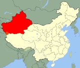
Xinjiang is an autonomous region (Xinjiang Uyghur Autonomous Region) of the People's Republic of China
. It is the largest Chinese administrative division and spans over 1.6 million km2. Xinjiang borders Russia
, Mongolia
, Kazakhstan
, Kyrgyzstan
, Tajikistan
, Afghanistan
, Pakistan
and India
, has abundant oil reserves and is China's largest natural gas-producing region.
Xinjiang was previously known as Xiyu (西域) or Qurighar (غەربىي دىيار), meaning Western Region
, under the Han Dynasty
, which drove the Xiongnu
empire out of the region in 60 BC. This was in an effort to secure the profitable Silk Road
. The name "Xinjiang", which literally means "New Frontier" or "New Border", was given during the Qing Dynasty
. It is home to a number of different ethnic groups including the Uyghur
, Han
, Kazakh
, Hui
, Kyrgyz and Mongol. There are over a dozen autonomous prefectures and counties for various minorities living in Xinjiang. Older English-language reference works often refer to the area as Chinese Turkestan, Sinkiang and East Turkestan
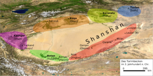
. Xinjiang is divided into the Dzungarian Basin in the north and the Tarim Basin
in the south by a mountain range. Only about 4.3% of Xinjiang's land area is fit for human habitation.
With a documented history of at least 2,500 years, there have been a succession of different peoples and empires vying for control over all or parts of these territories. Prior to the 21st century, all or part of the region has been ruled or influenced at various times by the Tocharians
, Yuezhi
, Xiongnu Empire, Kushan Empire
, Han Empire, Former Liang
, Former Qin
, Later Liang
, Western Liáng
, Tang Dynasty
, Uyghur Khaganate, Kara-Khanid Khanate
, Mongol Empire
(Yuan Dynasty
), Dzungar Khanate, Qing Dynasty
, Republic of China and since 1949 People's Republic of China
.
, or Uyghuristan. More specifically, at times, the term East Turkestan only referred to the Xinjiang area south of the Tian Shan
mountains, North of the Tian Shan was called Dzungaria
(Zungaria).
The general region of Xinjiang has been known by many other names in earlier times including: 西域 (Mandarin: xiyu) = 'Western Regions', Chinese Tartary, High Tartary, East Chagatay, Mugholistan, Kashgaria, Altishahr ('the six cities' of the Tarim), Little Bokhara and Serindia.
The name "Xinjiang", which literally means "New Frontier", was given during the Qing Dynasty
. In the early part of the Qing Dynasty, the name "Xinjiang" was used to refer to any area of a former Chinese dynasty that had been previously lost but was regained by the Qing—for example, part of present-day Xinjiang was known as "Western Region xinjiang", present-day Jinchuan County
was known as "Jinchuan xinjiang", etc. After 1821, the Qing changed the names of the other regained regions, and "Xinjiang" became the name specifically of present-day Xinjiang.
or Western Europe
), which takes up about one sixth of the country's territory. Xinjiang borders the Tibet Autonomous Region
and India
's Leh District
to the south and Qinghai
and Gansu
provinces to the southeast, Mongolia
to the east, Russia
to the north, and Kazakhstan
, Kyrgyzstan
, Tajikistan
, Afghanistan
, Pakistan
and India
to the west.
The east-west chain of the Tian Shan Mountains separate Dzungaria
in the north from the Tarim Basin
in the south. Dzungaria is dry steppe. The Tarim Basin is desert surrounded by oases. In the east is the Turpan Depression. In the west, the Tian Shan split, forming the Ili River
valley.
with lightish hair" or the Bai people in the Shan Hai Jing
, who lived beyond their northwestern border.
The well-preserved Tarim mummies
with Caucasoid
features, often with reddish or blond hair, today displayed at the Ürümqi
Museum and dated to the 3rd century BC, have been found in precisely the same area of the Tarim Basin. Various nomadic tribes, such as the Yuezhi
were part of the large migration of Indo-European
speaking peoples who were settled in eastern Central Asia
(possibly as far as Gansu
) at that time. The Ordos culture
situated at northern China east of the Yuezhi, are another example.
Nomadic cultures such as the Yuezhi are documented in the area of Xinjiang where the first known reference to the Yuezhi was made in 645 BC by the Chinese Guan Zhong
in his Guanzi 管子(Guanzi Essays: 73: 78: 80: 81). He described the Yuzhi 禺氏, or Niuzhi 牛氏, as a people from the north-west who supplied jade
to the Chinese from the nearby mountains of Yuzhi 禺氏 at Gansu. The supply of jade from the Tarim Basin from ancient times is indeed well documented archaeologically: "It is well known that ancient Chinese rulers had a strong attachment to jade. All of the jade items excavated from the tomb of Fuhao of the Shang dynasty
, more than 750 pieces, were from Khotan
in modern Xinjiang. As early as the mid-first millennium BC the Yuezhi engaged in the jade trade, of which the major consumers were the rulers of agricultural China.".
The nomadic tribes of the Yuezhi are also documented in detail in Chinese historical accounts, in particular the 2nd-1st century BC "Records of the Great Historian", or Shiji, by Sima Qian
, which state that they "were flourishing" but regularly in conflict with the neighboring tribe of the Xiongnu to the northeast. According to these accounts:
 Traversed by the Northern Silk Road
, Western Regions
or Xinjiang is the Chinese name for the Tarim
and Dzungaria
regions of what is now northwest China. At the beginning of the Han Dynasty
(206 BC – AD 220), the region was subservient to the Xiongnu
, a powerful nomadic people based in modern Mongolia
.
as an envoy to the states in the region, beginning several decades of struggle between the Xiongnu and Han China over dominance of the region, eventually ending in Chinese success. In 60 BC Han China established the Protectorate of the Western Regions
(西域都護府) at Wulei (烏壘; near modern Luntai
) to oversee the entire region as far west as the Pamir
.
During the usurpation of Wang Mang
in China, the dependent states of the protectorate rebelled and returned to domination in AD 13. Over the next century, Han China conducted several expeditions into the region, re-establishing the protectorate from 74 to 76, 91 to 107, and from 123 onward. This region was also ruled by Kushan Empire
between 114 and 168. After the fall of the Han Dynasty, the protectorate continued to be maintained by Cao Wei
(until 265) and the Western Jin Dynasty (from 265 onwards).
 A summary of Classical sources on the Seres
(Greek and Roman name of Xinjiang) (essentially Pliny
and Ptolemy
) gives the following account:
Ptolemy had quite good information on Xinjiang, taken from three different accounts.
one after the other, including Former Liang
, Former Qin
, Later Liang
, and Western Liáng
, all attempted to maintain the protectorate, with varying extents and degrees of success. After the final reunification of northern China under the Northern Wei
empire, its protectorate controlled what is now the southeastern third of Xinjiang. Local states such as Shule
, Yutian, Guizi and Qiemo controlled the western half, while the central region around Turpan was controlled by Gaochang
, remnants of a state (Northern Liang
) that once ruled part of what is now Gansu
province in northwestern China.
was established in 618, and would prove to be one of the most expansionist dynasties in Chinese history. Starting from the 620's and 630's, Tang China conducted a series of expeditions against the Tujue, eventually forcing the surrender of the western Tujue in 657. Xinjiang was placed under the Anxi Protectorate (安西都護府; "Protectorate Pacifying the West"). The protectorate did not outlast the decline of Tang China in the 8th century.
invaded Tang China on a wide front from Xinjiang to Yunnan
, occupied the Tang capital Chang'an in 763 for 16 days, and taking control of southern Xinjiang by the end of the century. At the same time, the Uyghur Khaganate took control of northern Xinjiang, as well as much of the rest of Central Asia, including Mongolia.
 As both Tibet and the Uyghur Khaganate declined in the mid-9th century, the Kara-Khanid Khanate
, which arose from a confederation of Turkic tribes scattered after the destruction of the Uyghur empire, took control of western Xinjiang in the 10th century and the 11th century. Meanwhile, after the Uyghur khanate in Mongolia had been smashed by the Kirghiz, branches of the Uyghurs
established themselves in the area around today's Turpan and Urumchi in 840. This Uyghur state would remain in eastern Xinjiang until the 13th century, though it would be subject to various overlords during that time. Some scholars have argued, that the Kara-Khanids were likewise "Uyghurs," as some of the components in the Kara-Khanid federation were likewise from the ruling clans of the Uyghur empire. The Kara-Khanids converted to Islam
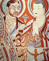
, whereas the Uyghur state in eastern Xinjiang remained Manicheaean, while tolerating Buddhism
and Christianity
.
In 1132, remnants of the Khitan Empire from Manchuria
entered Xinjiang, fleeing the onslaught of the Jurchens
into north China. They established an exile regime, the Kara-Khitan Khanate
, which became overlord over both Kara-Khanid-held and Uyghur-held parts of the Tarim Basin for the next century.
had unified Mongolia and began his advance west, the Uyghur state in the Turpan-Urumchi area offered its allegiance to the Mongols in 1209, contributing taxes and troops to the Mongol imperial effort. In return, the Uyghur rulers retained control of their kingdom. By contrast, Genghis Khan's Mongol Empire
conquered the Kara-Khitan in 1218. Because the Kara-Khitan had persecuted Islam, the Mongols were met as liberators in the Kashgar
area. During the era of the Mongol Empire, the Qubilaid Yuan Dynasty
vied for rule with the Chagatai Khanate
in the area, with the latter taking control of most of this region. After the break-up of the Chagatai Khanate into smaller khanates in the mid-14th century, the region fractured and was ruled by various Persianized Mongol Khans simultaneously, including the ones of Mogholistan (with the assistance of the local Dughlat Emirs), Uigurstan (later Turpan) and Kashgaria. These leaders engaged in numerous wars with each other and both the Timurid
s of Transoxania to the West and the Western Mongols to the East, the successor Chagatai
regime based in Mongolia and in China. Although there were high points in Persian culture reached (e.g. the Dughlat historian Hamid-mirza), succession crises and internal divisions (Kashgaria split in two for centuries) meant that this region almost completely fades from the history books during the 16th and 17th centuries. In the 17th century, the Mongolia
n Dzungars established an empire over much of the region.
tribes that formed and maintained one of the last nomadic empire
s. The Dzungar Khanate covered the area called Dzungaria
and stretched from the west end of the Great Wall of China
to present-day eastern Kazakhstan, and from present-day northern Kyrgyzstan
to southern Siberia
(most of this area is renamed to Xinjiang after the fall of the Dzungar Empire). It existed from the early 17th century to the mid-18th century.
 The Manchu
Qing dynasty
gained control over eastern Xinjiang as a result of a long struggle with the Zunghars (Dzungars) that began in the 17th century. In 1755, with the help of the Oirat nobel Amursana, the Qing attacked Ghulja, and captured the Zunghar khan. After Amursana's request to be declared Zunghar Khan went unanswered, he led a revolt against the Qing. Over the next two years, Qing armies destroyed the remnants of the Zunghar khanate and colonised parts of Xinjiang with Han and Hui Chinese.
The Dzungars
suffered important loss in the brutal campaigns and the smallpox
epidemic at the time. One writer, Wei Yuan
, described the resulting desolation in what is now northern Xinjiang as: "an empty plain for several thousand li
, with no Oirat yurt
except those surrendered." It has been estimated that 80% of the 600,000 or more Zunghars were destroyed by a combination of disease and warfare, and it took generations for it to recover.
After the defeat of the Dzungars, the Qing made members of a clan of sufi shaykhs known as the Khojas
, rulers in the western Tarim Basin, south of the Tianshan Mts. In 1758–59, however, rebellions against this arrangement broke out both north and south of the Tian Shan
mountains. The Qing was thus forced, contrary to its initial intent, to establish a form of direct military rule over both Zungharia (northern Xinjiang) and the Tarim Basin (southern Xinjiang). The Manchus put the whole region under the rule of a General of Ili , headquartered at the fort of Huiyuan
(the so-called "Manchu Kuldja", or Yili), 30 km west of Ghulja (Yining).
After 1759 state farms were established, "especially in the vicinity of Urumchi, where there was fertile, well-watered land and few people." From 1760 to 1830 more state farms were opened and the Chinese population in Xinjiang grew rapidly to about 155,000.
Jahangir Khoja invaded Kashgar in 1826 and the Khanate of Kokand conducted raids on Xinjiang. A large slave trade existed in Xinjiang during this time.
By the mid-19th century, the Russian Empire
was encroaching upon Qing China along its entire northern frontier. The Opium Wars and Taiping and other rebellion's in China proper
had severely restricted the dynasty's ability to maintain its garrisons in distant Xinjiang. In 1864 both Chinese Muslims (Hui
) and Uyghurs rebelled in Xinjiang cities, following an on-going Chinese Muslim Rebellion in Gansu
and Shaanxi
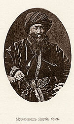
provinces further east. Because all of the non-Muslim population in Xinjiang were regarded as infidels and enemies to be exterminated, the rebellion resulted in incredible cruelties whenever the towns held by the Qing force were taken. Yaqub Beg's Turkic Muslim troops also committed massacres upon the Chinese Muslims. In 1865, Yaqub Beg
, a warlord from the neighbouring Khanate of Kokand
, entered Xinjiang via Kashgar, and conquered nearly all of Xinjiang over the next six years. At the Battle of Ürümqi (1870)
Yaqub Beg's Turkic forces, allied with a Han Chinese militia, attacked and besieged Chinese Muslim forces in Urumqi. In 1871, Russia took advantage of the chaotic situation and seized the rich Ili River
valley, including Gulja. By then, Qing China held onto only a few strongholds, including Tacheng
.
Yaqub Beg's rule lasted until General Zuo Zongtang
(also known as General Tso) reconquered the region between 1875 and 1877 for Qing China. In 1881, Qing China recovered the Gulja region through diplomatic negotiations (Treaty of Saint Petersburg (1881)
).
In 1884, (1882 according to some sources), Qing China established Xinjiang ("new frontier") as a province, formally applying onto it the political system of China proper, and dropping the old name of Huijiang or 'Muslimland'.
 In 1912, the Qing Dynasty was replaced by the Republic of China
. Yuan Dahua, the last Qing governor of Xinjiang, fled. One of his subordinates, Yang Zengxin
(杨增新), took control of the province and acceded in name to the Republic of China in March of the same year. Through Machiavellian politics and clever balancing of mixed ethnic constituencies, Yang maintained control over Xinjiang until his assassination in 1928.
The Kumul Rebellion
and other rebellions arose against his successor Jin Shuren
(金树仁) in the early 1930s throughout Xinjiang, involving Uyghurs, other Turkic groups, and Hui (Muslim) Chinese. Jin drafted White Russians to crush the revolt. In the Kashgar
region on 12 November 1933, the short-lived self-proclaimed East Turkistan Republic was declared, after some debate over whether the proposed independent state should be called "East Turkestan" or "Uyghuristan." The region claimed by the ETR in theory encompassed Kashgar
, Khotan
and Aqsu
prefectures in southwestern Xinjiang. The Chinese Muslim
Kuomintang
36th Division (National Revolutionary Army)
destroyed the army of the First East Turkestan Republic at the Battle of Kashgar (1934)
, bringing the Republic to an end after the Chinese Muslims executed the two Emirs of the Republic, Abdullah Bughra
and Nur Ahmad Jan Bughra
. The Soviet Union invaded the province in the Soviet Invasion of Xinjiang
. In the Xinjiang War (1937)
, the entire province was brought under the control of northeast Chinese warlord Sheng Shicai
(盛世才), who ruled Xinjiang for the next decade with close support from the Soviet Union
, many of whose ethnic and security policies Sheng instituted in Xinjiang. The Soviet Union maintained a military base in Xinjiang and had several military and economic advisors deployed in the region. Sheng invited a group of Chinese Communists to Xinjiang, including Mao Zedong
's brother Mao Zemin
, but in 1943, fearing a conspiracy, Sheng executed them all, including Mao Zemin.
support in what is now Ili Kazakh Autonomous Prefecture
(Ili, Tarbagatay and Altay Districts) in northern Xinjiang. The Second East Turkistan Republic came to an end when the People's Liberation Army
entered Xinjiang in 1949. Also, five ETR leaders, who would negotiate the final status of East Turkistan with the Chinese, died in an air crash in 1949 in Kazakh airspace.
The Chinese Muslim General Bai Chongxi
, advocated swamping Xinjiang with disbanded Chinese soldiers to prevent the Soviet union from seizing control during this time.
According to the PRC interpretation, the 2nd ETR was Xinjiang's revolution, a positive part of the communist revolution in China; the 2nd ETR acceded to and welcomed the PLA when it entered Xinjiang, a process known as the Peaceful Liberation of Xinjiang. However, independence advocates view the ETR as an effort to establish an independent state, and the subsequent PLA entry as an invasion.
The autonomous region of the PRC was established on 1 October 1955, replacing the province. The PRC's first nuclear test
was carried out at Lop Nur
, Xinjiang, on 16 October 1964. Although reports in western media report that between 100,000 and 200,000 people may have been killed in the testing, the Lop Nur area has not been permanently inhabited since about 1920 and PRC media dispute these numbers, but without providing an alternate number.
During the Great Chinese Famine (1958–1961), Xinjiang experienced a great emigration of residents both to the Soviet Union
and to East China
. After a number of student demonstrations in the 1980s, the Baren Township riot of April 1990 led to more than 20 deaths. 1997 saw the Ghulja Incident
and Urumqi bus bombs
, while police continue to battle with religious separatists from the East Turkestan Islamic Movement
.
Han Youwen
, a Salar General, once served as Vice Chairman of Xinjiang.
In recent years Xinjiang has been a focal point of ethnic and other tensions.
Recent incidents include the 2007 Xinjiang raid
, a thwarted 2008 suicide bombing attempt on a China Southern Airlines
flight, and the 2008 Xinjiang attack which resulted in the deaths of sixteen police officers four days before the Beijing Olympics.
Further incidents include the July 2009 Ürümqi riots, the September 2009 Xinjiang unrest
, and the 2010 Aksu bombing
that led to the trials of 376 people.
From 1949 to 2001, education has expanded greatly in the region, with 6,221 primary schools up from 1,335; 1,929 middle schools up from 9, and institutions of higher learning
at 21, up from 1. The illiteracy rate for young and middle-aged people has decreased to less than 2%. Agricultural science
has made inroads into the region, as well as innovative methods of road construction in the desert. Culturally, Xinjiang maintains 81 public libraries
and 23 museums, compared to none of each in 1949, and Xinjiang has 98 newspapers in 44 languages, up from 4 newspapers in 1952. According to official statistics, the ratios of doctors, medical workers, medical clinics, and hospital beds to people surpass the national average, and immunization
rates have reached 85%.
and Hui
minorities . (Two of the seven prefectures are in turn part of Ili, an autonomous prefecture.) These are then divided into eleven districts, twenty county-level cities, sixty-two counties, and six autonomous counties. Four of the county-level cities do not belong to any prefecture, and are de facto administered by the Xinjiang Production and Construction Corps
. Sub-level divisions of the Xinjiang Uyghur Autonomous Region is shown in the picture to the right, and described in the table below:
 Xinjiang is the largest political subdivision of China—it accounts for more than one sixth of China's total territory and a quarter of its boundary length. It is split by the Tian Shan
mountain range , which divides it into two large basins: the Dzungarian Basin in the north, and the Tarim Basin
in the south. Much of the Tarim Basin is dominated by the Taklimakan Desert. The lowest point in Xinjiang, and in the entire PRC, is the Turpan Depression, 155 metres below sea level; its highest point is the mountain K2
, 8611 metres above sea level
, on the border with Pakistan
. Other mountain ranges include the Pamir Mountains
in the southeast, the Karakoram
in the south, and the Altai Mountains in the north.
Most of Xinjiang is young geologically, having been formed from the collision of the Indian plate with the Eurasian plate, forming the Tian Shan
, Kunlun Shan, and Pamir
mountain ranges. Consequently, Xinjiang is a major earthquake
zone. Older geological formations occur principally in the far north where the Junggar Block is geologically part of Kazakhstan
, and in the east which is part of the North China Craton
.
Xinjiang has within its borders the point of land remotest from the sea, the so-called Eurasian pole of inaccessibility (46°16.8′N 86°40.2′E) in the Dzoosotoyn Elisen Desert, 1,645 miles (2648 km) from the nearest coastline (straight-line distance).
The Tian Shan
mountain range marks the Xinjiang-Kyrgyzstan border at the Torugart Pass
(3752 m). The Karakorum highway (KKH) links Islamabad
, Pakistan
with Kashgar
over the Khunjerab Pass
.
Rivers include the Tarim River
.
or desert climate
(Köppen
BSk or BWk, respectively) prevails in Xinjiang. The region is marked by great seasonal differences in temperature.
Xinjiang Committee
List of Chairmen of Xinjiang Government
s, pear
s, cotton
, wheat
, silk
, walnut
s and sheep. Xinjiang also has large deposits of minerals and oil
.
In the late 19th century the region was noted for producing salt
, soda, borax
, gold
, jade
and coal
.
Xinjiang's nominal GDP was approximately 220 billion RMB
(28 billion USD) in 2004, and increased to 427.4 billion RMB (62.6 billion USD) in 2009, due to exploration of the regions abundant reserves of coal, crude oil and natural and the China Western Development
policy introduced by the State Council to boost economic development in Western China. Its per capita GDP for 2009 was 19,798 RMB (2,898 USD), with a growth rate of 1.7%. Southern Xinjiang, with 95 per cent non-Han population has an average per capita income half that of Xinjiang as a whole.
The oil and gas
extraction industry in Aksu and Karamay
is booming, with the West–East Gas Pipeline connecting to Shanghai. The oil and petrochemical sector account for 60% of Xinjiang's local economy.
Xinjiang's export
s amounted to 19.3 billion USD, while imports turned out to be 2.9 billion USD in 2008. Most of the overall import/export volume in Xinjiang was directed to and from Kazakhstan
through Ala Pass. China's first border free trade zone
(Horgos Free Trade Zone) was located at the Xinjiang-Kazakhstan border city of Horgos
. Horgos is the largest "land port" in China's western region and it has easy access to the Central Asia
n market. Xinjiang also opened its second border trade market to Kazakhstan in March 2006, the Jeminay Border Trade Zone.
In July 2010 China Daily
reported that:
Urumqi Economic and Technological Development Zone is located northwest of Urumqi. It was approved in 1994 by the State Council as a national level economic and technological development zones. It is located 1.5 km away from the Urumqi International Airport, 2 km from the North Railway Station, and 10 km from the city center. Wu Chang Expressway and 312 National Road passes through the Zone. The development has unique resources and geographical advantages. Xinjiang's vast land, rich in various resources, borders 8 countries. As the leading economic zone, it brings together the resources of Xinjiang's industrial development, capital, technology, information, personnel and other factors of production.
Urumuqi Export Processing Zone is located in Urumuqi Economic and Technology Development Zone. It was established in 2007 as a state-level export processing zone.
Urumuqi Hi-Tech Industrial Development Zone was established in 1992, and it is the only high-tech development zone in Xinjiang, China. There are more than 3470 enterprises in the zone, of which 23 are Fortune 500 companies. It has a planned area of 9.8 square kilometres, and it is divided into 4 zones. There are future plans to expand the zone.
 The earliest Tarim mummies
, dated to 1800 BC, are of a Caucasoid physical type. East Asian migrants arrived in the eastern portions of the Tarim Basin
about 3,000 years ago, while the Uighur peoples arrived after the collapse of the Orkon Uighur Kingdom, based in modern-day Mongolia, around the year 842.
Muslim Turkic peoples
in Xinjiang include Uyghurs
, Uzbeks
, Kyrgyz, Tatars and the Kazakhs
; Muslim Iranian peoples
include Pamiris and the Sarikoli
s/Wakhis
(often conflated as Pamiris); and Muslim Sino-Tibetan peoples such as the Hui. Other PRC ethnic groups in the region include Han
, Mongols
(Oirats
, Dagur, Dongxiang
), Russians, Xibe
s, and Manchu
s. As of 1945, there were up to 70,000 persons of Russian origin living in Xinjiang.
The Han Chinese
of Xinjiang arrived at different times, from different directions and social backgrounds: they are descendants of criminals and officials who had been exiled from China proper during the second half of the eighteenth and first half of the 19th centuries; descendants of families of military and civil officers from Hunan
, Yunnan
, Gansu
and Manchuria
; descendants of merchants from Shanxi
, Tianjin
, Hubei
and Hunan
and descendants of peasants who started immigrating into the region in 1776.
Some Uighur scholars claim descent from both the Turkic Uighurs and the pre-Turkic Tocharians
(or Tokharians, whose language was Indo-European
), and relatively fair-skin, hair and eyes, as well as other so-called 'Caucasoid' physical traits, are not uncommon among them. In general Uyghurs resemble those peoples who live around them in Afghanistan, Kyrgyzstan, Uzbekistan, Kazakhstan, and Pakistan.
In 2002, there were 9,632,600 males (growth rate of 1.0%) and 9,419,300 females (growth rate of 2.2%). The population overall growth rate was 10.9‰, with 16.3‰ of birth rate
and 5.4‰ mortality rate
.
 At the start of the 19th century, forty years after the Qing reconquest, there were something like 155,000 Han and Hui Chinese in northern Xinjiang, and somewhat more than twice that number of Uyghurs in southern Xinjiang. A census of the time tabulated ethnic shares of the population as 60% Turkic
and 30% Han
. Before 1831 only a few hundred Chinese merchants lived in southern Xinjiang oases(Tarim Basin), and only a few Uyghurs lived in northern Xinjiang (Dzungaria
). After 1831 the Qing permitted and encouraged Han Chinese migration into the Tarim basin in southern Xinjiang, although with very little success, and stationed permanent troops on the land there as well. Political killings and expulsions of non Uyghur populations in the uprisings of the 1860s and 1930s saw them experience a sharp decline as a percentage of the total population though they rose once again in the periods of stability following 1880 (which saw Xinjiang increase its population from 1.2 million) and 1949. From a low of 7% in 1953, the Han began to return to Xinjiang between then and 1964, where they comprised 33% of the population (54% Uyghur), similarly to Qing times. A decade later, at the beginning of the Chinese economic reform
in 1978, the demographic balance was 46% Uyghur and 40% Han; this has not changed drastically until the last census in 2000, with the Uyghur population reduced to 42%. Military personnel are not counted and national minorities are undercounted in the Chinese census, as in most censuses. While some of the shift has be attributed to an increased Han presence, Uyghurs have also emigrated to other parts of China, where their numbers have increased steadily. Uyghur independence activists claim that the Han population will dilute the Uyghur character of the region, but the Han and Hui Chinese mostly live in northern Xinjiang Dzungaria
, and are separated from areas of historical Uyghur dominance south of the Tian Shan
mountains(southwestern Xinjiang), where Uyghurs account for about 90% of the population.
In general, Uyghurs
are the majority in southwestern Xinjiang, including the prefectures of Kashgar
, Khotan
, Kizilsu, and Aksu
(about 80% of Xinjiang's Uyghurs live in those four prefectures), as well as Turpan prefecture in eastern Xinjiang. Han are the majority in eastern and northern Xinjiang(Dzungaria), including the cities of Urumqi
, Karamay
, Shihezi
and the prefectures of Changjyi
, Bortala
, Bayin'gholin
, Ili
(especially the cities of Kuitun
), and Kumul. Kazakhs
are mostly concentrated in Ili
prefecture in northern Xinjiang. Kazaks are the majority in the northernmost part of Xinjiang.
. Afaq Khoja Mausoleum
and Id Kah Mosque
in Kashgar
are among the most important Islamic sites in Xinjiang. Emin Minaret
is another key Islamic site, in Turfan. Bezeklik Thousand Buddha Caves
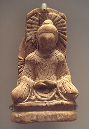
is a major Buddhist site. According to one source, more than 2% of the population are Christians. Action against Christian activity tends to be stricter than in other parts of China.
operates the Urumqi People Broadcasting Station and the Xinjiang People Broadcasting Station, broadcasting in Mandarin, Uyghur
, Kazakh
and Mongolian
.
, there were fifty minority-language newspapers published in Xinjiang, including the Qapqal News
, the world's only Xibe-language
newspaper. The Xinjiang Economic Daily
is considered one of China's most dynamic newspapers.
For a time after the July 2009 riots, authorities placed restrictions on the internet
and text messaging
, gradually permitting access to websites like Xinhua's, until restoring Internet to the same level as the rest of China on May 14, 2010.
professional basketball team of the Chinese Basketball Association
.
The capital, Urumqi, is also home to the Xinjiang University
baseball team, an integrated Uyghur and Han group profiled in the documentary film, Diamond in the Dunes
.
The construction of the first expressway in the mountainous area of Xinjiang began a new stage in its construction on 24 July 2007. The 56 km highway linking Sayram Lake and Guozi Valley in Northern Xinjiang area had cost 2.39 billion yuan. The expressway is designed to improve the speed of national highway 312 in northern Xinjiang. The project started in August 2006 and several stages have been fully operational since March 2007. Over 3,000 construction workers have been involved. The 700 m-long Guozi Valley Cable Bridge over the expressway is now currently being constructed, with the 24 main pile foundations already completed. Highway 312 national highway Xinjiang section, connects Xinjiang with China's east coast, central and western Asia, plus some parts of Europe. It is a key factor in Xinjiang's economic development
. The population it covers is around 40 percent of the overall in Xinjiang, who contribute half of the GDP in the area.
to Lanzhou
through the Hexi Corridor
in Gansu Province. This railway connects the regional capital, Ürümqi
, with Turpan and Hami
in eastern Xinjiang. West of Ürümqi, the Northern Xinjiang (Beijiang) Railway
runs along the northern footslopes of the Tian Shan
range through Changji, Shihezi
, Kuytun and Jinghe to the Kazakh
border at Alashankou
, where it links up with the Turkestan-Siberia Railway
of Central Asia
. The Lanxin and Beijiang lines form part of the Trans-Eurasian Continental Railway
, which extends from Rotterdam
, on the North Sea
, to Lianyungang
, on the East China Sea
.
The Second Ürümqi-Jinghe Railway
opened in 2009 to supplement rail transport capacity on the Northern Xinjiang Railway between Ürümqi and Jinghe. From Jinghe, the Jinghe-Yining-Horgos Railway heads southwest into the Ili River
Valley to Yining, Huocheng, and Khorgos
, a second rail border crossing with Kazakhstan. From Kuytun, the Kuytun-Beitun Railway
runs north into the Junggar Basin to Karamay
and Beitun, near Altay in northern Xinjiang. The Ürümqi-Dzungaria Railway
connects Ürümqi with coal fields in the eastern Junggar Basin.
The Southern Xinjiang (Nanjiang) Railway
branches off of the Lanxin Line at Turpan and heads southwest along the southern footslopes of the Tian Shan
into the Tarim Basin
, with stops at Yanqi, Korla
, Kuqa, Aksu, Maralbexi (Bachu)
, Artux
, and Kashgar
. From Kashgar, the Kashgar-Hotan Railway
, follows the southern rim of the Tarim to Hotan, with stops at Shule
, Akto, Yengisar, Shache (Yarkant), Yecheng (Karghilik)
, Moyu (Karakax).
A high-speed railway between Urumqi and Lanzhou is currently under construction.
People's Republic of China
China , officially the People's Republic of China , is the most populous country in the world, with over 1.3 billion citizens. Located in East Asia, the country covers approximately 9.6 million square kilometres...
. It is the largest Chinese administrative division and spans over 1.6 million km2. Xinjiang borders Russia
Russia
Russia or , officially known as both Russia and the Russian Federation , is a country in northern Eurasia. It is a federal semi-presidential republic, comprising 83 federal subjects...
, Mongolia
Mongolia
Mongolia is a landlocked country in East and Central Asia. It is bordered by Russia to the north and China to the south, east and west. Although Mongolia does not share a border with Kazakhstan, its western-most point is only from Kazakhstan's eastern tip. Ulan Bator, the capital and largest...
, Kazakhstan
Kazakhstan
Kazakhstan , officially the Republic of Kazakhstan, is a transcontinental country in Central Asia and Eastern Europe. Ranked as the ninth largest country in the world, it is also the world's largest landlocked country; its territory of is greater than Western Europe...
, Kyrgyzstan
Kyrgyzstan
Kyrgyzstan , officially the Kyrgyz Republic is one of the world's six independent Turkic states . Located in Central Asia, landlocked and mountainous, Kyrgyzstan is bordered by Kazakhstan to the north, Uzbekistan to the west, Tajikistan to the southwest and China to the east...
, Tajikistan
Tajikistan
Tajikistan , officially the Republic of Tajikistan , is a mountainous landlocked country in Central Asia. Afghanistan borders it to the south, Uzbekistan to the west, Kyrgyzstan to the north, and China to the east....
, Afghanistan
Afghanistan
Afghanistan , officially the Islamic Republic of Afghanistan, is a landlocked country located in the centre of Asia, forming South Asia, Central Asia and the Middle East. With a population of about 29 million, it has an area of , making it the 42nd most populous and 41st largest nation in the world...
, Pakistan
Pakistan
Pakistan , officially the Islamic Republic of Pakistan is a sovereign state in South Asia. It has a coastline along the Arabian Sea and the Gulf of Oman in the south and is bordered by Afghanistan and Iran in the west, India in the east and China in the far northeast. In the north, Tajikistan...
and India
India
India , officially the Republic of India , is a country in South Asia. It is the seventh-largest country by geographical area, the second-most populous country with over 1.2 billion people, and the most populous democracy in the world...
, has abundant oil reserves and is China's largest natural gas-producing region.
Xinjiang was previously known as Xiyu (西域) or Qurighar (غەربىي دىيار), meaning Western Region
Western Regions
The Western Regions or Xiyu was a historical name specified in the Chinese chronicles between the 3rd century BC to 8th century AD that referred to the regions west of Jade Gate, most often Central Asia or sometimes more specifically the easternmost portion of it The Western Regions or Xiyu was a...
, under the Han Dynasty
Han Dynasty
The Han Dynasty was the second imperial dynasty of China, preceded by the Qin Dynasty and succeeded by the Three Kingdoms . It was founded by the rebel leader Liu Bang, known posthumously as Emperor Gaozu of Han. It was briefly interrupted by the Xin Dynasty of the former regent Wang Mang...
, which drove the Xiongnu
Xiongnu
The Xiongnu were ancient nomadic-based people that formed a state or confederation north of the agriculture-based empire of the Han Dynasty. Most of the information on the Xiongnu comes from Chinese sources...
empire out of the region in 60 BC. This was in an effort to secure the profitable Silk Road
Silk Road
The Silk Road or Silk Route refers to a historical network of interlinking trade routes across the Afro-Eurasian landmass that connected East, South, and Western Asia with the Mediterranean and European world, as well as parts of North and East Africa...
. The name "Xinjiang", which literally means "New Frontier" or "New Border", was given during the Qing Dynasty
Qing Dynasty
The Qing Dynasty was the last dynasty of China, ruling from 1644 to 1912 with a brief, abortive restoration in 1917. It was preceded by the Ming Dynasty and followed by the Republic of China....
. It is home to a number of different ethnic groups including the Uyghur
Uyghur people
The Uyghur are a Turkic ethnic group living in Eastern and Central Asia. Today, Uyghurs live primarily in the Xinjiang Uyghur Autonomous Region in the People's Republic of China...
, Han
Han Chinese
Han Chinese are an ethnic group native to China and are the largest single ethnic group in the world.Han Chinese constitute about 92% of the population of the People's Republic of China , 98% of the population of the Republic of China , 78% of the population of Singapore, and about 20% of the...
, Kazakh
Kazakhs
The Kazakhs are a Turkic people of the northern parts of Central Asia ....
, Hui
Hui people
The Hui people are an ethnic group in China, defined as Chinese speaking people descended from foreign Muslims. They are typically distinguished by their practice of Islam, however some also practice other religions, and many are direct descendants of Silk Road travelers.In modern People's...
, Kyrgyz and Mongol. There are over a dozen autonomous prefectures and counties for various minorities living in Xinjiang. Older English-language reference works often refer to the area as Chinese Turkestan, Sinkiang and East Turkestan
East Turkestan
East Turkestan is a controversial political term with multiple meanings depending on context and usage...
. Xinjiang is divided into the Dzungarian Basin in the north and the Tarim Basin
Tarim Basin
The Tarim Basin is a large endorheic basin occupying an area of about . It is located in the Xinjiang Uyghur Autonomous Region in China's far west. Its northern boundary is the Tian Shan mountain range and its southern is the Kunlun Mountains on the northern edge of the Tibetan Plateau. The...
in the south by a mountain range. Only about 4.3% of Xinjiang's land area is fit for human habitation.
With a documented history of at least 2,500 years, there have been a succession of different peoples and empires vying for control over all or parts of these territories. Prior to the 21st century, all or part of the region has been ruled or influenced at various times by the Tocharians
Tocharians
The Tocharians were the Tocharian-speaking inhabitants of the Tarim Basin, making them the easternmost speakers of Indo-European languages in antiquity. They were known as, or at least closely related to, the Yuezhi of Chinese sources...
, Yuezhi
Yuezhi
The Yuezhi, or Rouzhi , also known as the Da Yuezhi or Da Rouzhi , were an ancient Central Asian people....
, Xiongnu Empire, Kushan Empire
Kushan Empire
The Kushan Empire originally formed in the early 1st century AD under Kujula Kadphises in the territories of ancient Bactria on either side of the middle course of the Oxus in what is now northern Afghanistan, Pakistan, and southern Tajikistan and Uzbekistan.During the 1st and early 2nd centuries...
, Han Empire, Former Liang
Former Liang
The Former Liang was a state of the Sixteen Kingdoms during the Jin dynasty in China. It was founded by the Zhang family of the Han Chinese...
, Former Qin
Former Qin
The Former Qin was a state of the Sixteen Kingdoms in China. Founded by the Fu family of the Di ethnicity, it completed the unification of North China in 376. Its capital had been Xi'an up to the death of the ruler Fu Jiān. Despite its name, the Former Qin was much later and less powerful than...
, Later Liang
Later Liang
The Later Liang was a state of the Sixteen Kingdoms during the Jin Dynasty in China. It was founded by the Lü family of the Di ethnicity.All rulers of the Later Liang proclaimed themselves "Heavenly Prince" ....
, Western Liáng
Western Liang
The Western Liang was a state of the Sixteen Kingdoms in China. It was founded by the Li family of the Han Chinese. The founder of the Tang Dynasty, Li Yuan , traced his ancestry to the Western Liang rulers....
, Tang Dynasty
Tang Dynasty
The Tang Dynasty was an imperial dynasty of China preceded by the Sui Dynasty and followed by the Five Dynasties and Ten Kingdoms Period. It was founded by the Li family, who seized power during the decline and collapse of the Sui Empire...
, Uyghur Khaganate, Kara-Khanid Khanate
Kara-Khanid Khanate
The Kara-Khanid Khanate was a confederation of Turkic tribes ruled by a dynasty known in literature as the Karakhanids or Ilek Khanids, . Both dynastic names represent titles with Kara Kağan being the most important Turkish title up till the end of the dynasty.The Khanate ruled Transoxania in...
, Mongol Empire
Mongol Empire
The Mongol Empire , initially named as Greater Mongol State was a great empire during the 13th and 14th centuries...
(Yuan Dynasty
Yuan Dynasty
The Yuan Dynasty , or Great Yuan Empire was a ruling dynasty founded by the Mongol leader Kublai Khan, who ruled most of present-day China, all of modern Mongolia and its surrounding areas, lasting officially from 1271 to 1368. It is considered both as a division of the Mongol Empire and as an...
), Dzungar Khanate, Qing Dynasty
Qing Dynasty
The Qing Dynasty was the last dynasty of China, ruling from 1644 to 1912 with a brief, abortive restoration in 1917. It was preceded by the Ming Dynasty and followed by the Republic of China....
, Republic of China and since 1949 People's Republic of China
People's Republic of China
China , officially the People's Republic of China , is the most populous country in the world, with over 1.3 billion citizens. Located in East Asia, the country covers approximately 9.6 million square kilometres...
.
Names
Older English-language reference works often refer to the area as Chinese Turkestan, Sinkiang, East TurkestanEast Turkestan
East Turkestan is a controversial political term with multiple meanings depending on context and usage...
, or Uyghuristan. More specifically, at times, the term East Turkestan only referred to the Xinjiang area south of the Tian Shan
Tian Shan
The Tian Shan , also spelled Tien Shan, is a large mountain system located in Central Asia. The highest peak in the Tian Shan is Victory Peak , ....
mountains, North of the Tian Shan was called Dzungaria
Dzungaria
Dzungaria, also called Zungaria, is a geographical region in northwest China corresponding to the northern half of Xinjiang. It covers approximately , lying mostly within Xinjiang, and extending into western Mongolia and eastern Kazakhstan...
(Zungaria).
The general region of Xinjiang has been known by many other names in earlier times including: 西域 (Mandarin: xiyu) = 'Western Regions', Chinese Tartary, High Tartary, East Chagatay, Mugholistan, Kashgaria, Altishahr ('the six cities' of the Tarim), Little Bokhara and Serindia.
The name "Xinjiang", which literally means "New Frontier", was given during the Qing Dynasty
Qing Dynasty
The Qing Dynasty was the last dynasty of China, ruling from 1644 to 1912 with a brief, abortive restoration in 1917. It was preceded by the Ming Dynasty and followed by the Republic of China....
. In the early part of the Qing Dynasty, the name "Xinjiang" was used to refer to any area of a former Chinese dynasty that had been previously lost but was regained by the Qing—for example, part of present-day Xinjiang was known as "Western Region xinjiang", present-day Jinchuan County
Jinchuan County
Jinchuan County is a county of Sichuan Province, China. It is under the administration of the Ngawa Tibetan and Qiang Autonomous Prefecture....
was known as "Jinchuan xinjiang", etc. After 1821, the Qing changed the names of the other regained regions, and "Xinjiang" became the name specifically of present-day Xinjiang.
Description
Xinjiang is a large, sparsely populated area, spanning over 1.6 million km2 (comparable in size to IranIran
Iran , officially the Islamic Republic of Iran , is a country in Southern and Western Asia. The name "Iran" has been in use natively since the Sassanian era and came into use internationally in 1935, before which the country was known to the Western world as Persia...
or Western Europe
Western Europe
Western Europe is a loose term for the collection of countries in the western most region of the European continents, though this definition is context-dependent and carries cultural and political connotations. One definition describes Western Europe as a geographic entity—the region lying in the...
), which takes up about one sixth of the country's territory. Xinjiang borders the Tibet Autonomous Region
Tibet Autonomous Region
The Tibet Autonomous Region , Tibet or Xizang for short, also called the Xizang Autonomous Region is a province-level autonomous region of the People's Republic of China , created in 1965....
and India
India
India , officially the Republic of India , is a country in South Asia. It is the seventh-largest country by geographical area, the second-most populous country with over 1.2 billion people, and the most populous democracy in the world...
's Leh District
Leh District
Leh is one of the two districts located in Ladakh, the other being the Kargil District to the west, in the state of Jammu and Kashmir, India. It is the second largest district in India in terms of area. It is bounded on the north by Ghanche District , a small border with Xinjiang, China, via the...
to the south and Qinghai
Qinghai
Qinghai ; Oirat Mongolian: ; ; Salar:) is a province of the People's Republic of China, named after Qinghai Lake...
and Gansu
Gansu
' is a province located in the northwest of the People's Republic of China.It lies between the Tibetan and Huangtu plateaus, and borders Mongolia, Inner Mongolia, and Ningxia to the north, Xinjiang and Qinghai to the west, Sichuan to the south, and Shaanxi to the east...
provinces to the southeast, Mongolia
Mongolia
Mongolia is a landlocked country in East and Central Asia. It is bordered by Russia to the north and China to the south, east and west. Although Mongolia does not share a border with Kazakhstan, its western-most point is only from Kazakhstan's eastern tip. Ulan Bator, the capital and largest...
to the east, Russia
Russia
Russia or , officially known as both Russia and the Russian Federation , is a country in northern Eurasia. It is a federal semi-presidential republic, comprising 83 federal subjects...
to the north, and Kazakhstan
Kazakhstan
Kazakhstan , officially the Republic of Kazakhstan, is a transcontinental country in Central Asia and Eastern Europe. Ranked as the ninth largest country in the world, it is also the world's largest landlocked country; its territory of is greater than Western Europe...
, Kyrgyzstan
Kyrgyzstan
Kyrgyzstan , officially the Kyrgyz Republic is one of the world's six independent Turkic states . Located in Central Asia, landlocked and mountainous, Kyrgyzstan is bordered by Kazakhstan to the north, Uzbekistan to the west, Tajikistan to the southwest and China to the east...
, Tajikistan
Tajikistan
Tajikistan , officially the Republic of Tajikistan , is a mountainous landlocked country in Central Asia. Afghanistan borders it to the south, Uzbekistan to the west, Kyrgyzstan to the north, and China to the east....
, Afghanistan
Afghanistan
Afghanistan , officially the Islamic Republic of Afghanistan, is a landlocked country located in the centre of Asia, forming South Asia, Central Asia and the Middle East. With a population of about 29 million, it has an area of , making it the 42nd most populous and 41st largest nation in the world...
, Pakistan
Pakistan
Pakistan , officially the Islamic Republic of Pakistan is a sovereign state in South Asia. It has a coastline along the Arabian Sea and the Gulf of Oman in the south and is bordered by Afghanistan and Iran in the west, India in the east and China in the far northeast. In the north, Tajikistan...
and India
India
India , officially the Republic of India , is a country in South Asia. It is the seventh-largest country by geographical area, the second-most populous country with over 1.2 billion people, and the most populous democracy in the world...
to the west.
The east-west chain of the Tian Shan Mountains separate Dzungaria
Dzungaria
Dzungaria, also called Zungaria, is a geographical region in northwest China corresponding to the northern half of Xinjiang. It covers approximately , lying mostly within Xinjiang, and extending into western Mongolia and eastern Kazakhstan...
in the north from the Tarim Basin
Tarim Basin
The Tarim Basin is a large endorheic basin occupying an area of about . It is located in the Xinjiang Uyghur Autonomous Region in China's far west. Its northern boundary is the Tian Shan mountain range and its southern is the Kunlun Mountains on the northern edge of the Tibetan Plateau. The...
in the south. Dzungaria is dry steppe. The Tarim Basin is desert surrounded by oases. In the east is the Turpan Depression. In the west, the Tian Shan split, forming the Ili River
Ili River
thumb|right|300px|Map of the Lake Balkhash drainage basin showing the Ili River and its tributariesThe Ili River is a river in northwestern China and southeastern Kazakhstan .It is long, of which is in Kazakhstan...
valley.
Early history
According to J.P. Mallory, the Chinese sources describe the existence of "white peopleWhite people
White people is a term which usually refers to human beings characterized, at least in part, by the light pigmentation of their skin...
with lightish hair" or the Bai people in the Shan Hai Jing
Shan Hai Jing
Shan Hai Jing is a Chinese classic text, and a compilation of early geography and myth. Versions of the text have existed since the 4th century BC, and by the early Han Dynasty it had reached its final form. It is largely a fabled geographical and cultural account of pre-Qin China as well as a...
, who lived beyond their northwestern border.
The well-preserved Tarim mummies
Tarim mummies
The Tarim mummies are a series of mummies discovered in the Tarim Basin in present-day Xinjiang, China, which date from 1900 BC to 200 AD. Some of the mummies are frequently associated with the presence of the Indo-European Tocharian languages in the Tarim Basin, although the evidence is not...
with Caucasoid
Caucasian race
The term Caucasian race has been used to denote the general physical type of some or all of the populations of Europe, North Africa, the Horn of Africa, Western Asia , Central Asia and South Asia...
features, often with reddish or blond hair, today displayed at the Ürümqi
Ürümqi
Ürümqi , formerly Tihwa , is the capital of Xinjiang Uyghur Autonomous Region of the People's Republic of China, in the northwest of the country....
Museum and dated to the 3rd century BC, have been found in precisely the same area of the Tarim Basin. Various nomadic tribes, such as the Yuezhi
Yuezhi
The Yuezhi, or Rouzhi , also known as the Da Yuezhi or Da Rouzhi , were an ancient Central Asian people....
were part of the large migration of Indo-European
Indo-European languages
The Indo-European languages are a family of several hundred related languages and dialects, including most major current languages of Europe, the Iranian plateau, and South Asia and also historically predominant in Anatolia...
speaking peoples who were settled in eastern Central Asia
Central Asia
Central Asia is a core region of the Asian continent from the Caspian Sea in the west, China in the east, Afghanistan in the south, and Russia in the north...
(possibly as far as Gansu
Gansu
' is a province located in the northwest of the People's Republic of China.It lies between the Tibetan and Huangtu plateaus, and borders Mongolia, Inner Mongolia, and Ningxia to the north, Xinjiang and Qinghai to the west, Sichuan to the south, and Shaanxi to the east...
) at that time. The Ordos culture
Ordos culture
The Ordos culture comprises the period from Upper Paleolithic to the late Bronze age at the Ordos Desert, in the south of the Inner Mongolian Autonomous Region of the People's Republic of China...
situated at northern China east of the Yuezhi, are another example.
Nomadic cultures such as the Yuezhi are documented in the area of Xinjiang where the first known reference to the Yuezhi was made in 645 BC by the Chinese Guan Zhong
Guan Zhong
Guǎn Zhòng was a politician and statesman during the Spring and Autumn Period of Chinese history. His given name was Yíwú . Zhong was his courtesy name. Recommended by Bao Shuya, he was appointed Prime Minister by Duke Huan of Qi in 685 BC.-Achievements:Guan Zhong modernized the Qi State by...
in his Guanzi 管子(Guanzi Essays: 73: 78: 80: 81). He described the Yuzhi 禺氏, or Niuzhi 牛氏, as a people from the north-west who supplied jade
Jade
Jade is an ornamental stone.The term jade is applied to two different metamorphic rocks that are made up of different silicate minerals:...
to the Chinese from the nearby mountains of Yuzhi 禺氏 at Gansu. The supply of jade from the Tarim Basin from ancient times is indeed well documented archaeologically: "It is well known that ancient Chinese rulers had a strong attachment to jade. All of the jade items excavated from the tomb of Fuhao of the Shang dynasty
Shang Dynasty
The Shang Dynasty or Yin Dynasty was, according to traditional sources, the second Chinese dynasty, after the Xia. They ruled in the northeastern regions of the area known as "China proper" in the Yellow River valley...
, more than 750 pieces, were from Khotan
Khotan
Hotan , or Hetian , also spelled Khotan, is the seat of the Hotan Prefecture in Xinjiang, China. It was previously known in Chinese as 于窴/於窴 and to 19th-century European explorers as Ilchi....
in modern Xinjiang. As early as the mid-first millennium BC the Yuezhi engaged in the jade trade, of which the major consumers were the rulers of agricultural China.".
The nomadic tribes of the Yuezhi are also documented in detail in Chinese historical accounts, in particular the 2nd-1st century BC "Records of the Great Historian", or Shiji, by Sima Qian
Sima Qian
Sima Qian was a Prefect of the Grand Scribes of the Han Dynasty. He is regarded as the father of Chinese historiography for his highly praised work, Records of the Grand Historian , a "Jizhuanti"-style general history of China, covering more than two thousand years from the Yellow Emperor to...
, which state that they "were flourishing" but regularly in conflict with the neighboring tribe of the Xiongnu to the northeast. According to these accounts:
The Yuezhi originally lived in the area between the Qilian or Heavenly Mountains (Tian ShanTian ShanThe Tian Shan , also spelled Tien Shan, is a large mountain system located in Central Asia. The highest peak in the Tian Shan is Victory Peak , ....
) and DunhuangDunhuangDunhuang is a city in northwestern Gansu province, Western China. It was a major stop on the ancient Silk Road. It was also known at times as Shāzhōu , or 'City of Sands', a name still used today...
, but after they were defeated by the XiongnuXiongnuThe Xiongnu were ancient nomadic-based people that formed a state or confederation north of the agriculture-based empire of the Han Dynasty. Most of the information on the Xiongnu comes from Chinese sources...
they moved far away to the west, beyond DayuanDayuanThe Dayuan or Ta-Yuan were a people of Ferghana in Central Asia, described in the Chinese historical works of Records of the Grand Historian and the Book of Han. It is mentioned in the accounts of the famous Chinese explorer Zhang Qian in 130 BCE and the numerous embassies that followed him into...
, where they attacked and conquered the people of DaxiaDaxiaDaxia, Ta-Hsia, or Ta-Hia is the name given in antiquity by the Han Chinese to the territory of Bactria....
and set up the court of their king on the northern bank of the Gui [= Oxus] River. A small number of their people who were unable to make the journey west sought refuge among the Qiang barbarians in the Southern Mountains, where they are known as the Lesser Yuezhi.
Xiongnu Empire
Northern Silk Road
The Northern Silk Road is a prehistoric trackway in northern China originating in the early capital of Xi'an and extending north of the Taklamakan Desert to reach the ancient kingdoms of Parthia, Bactria and eventually Persia and Rome. It is the northern-most branch of several Silk Roads providing...
, Western Regions
Western Regions
The Western Regions or Xiyu was a historical name specified in the Chinese chronicles between the 3rd century BC to 8th century AD that referred to the regions west of Jade Gate, most often Central Asia or sometimes more specifically the easternmost portion of it The Western Regions or Xiyu was a...
or Xinjiang is the Chinese name for the Tarim
Tarim Basin
The Tarim Basin is a large endorheic basin occupying an area of about . It is located in the Xinjiang Uyghur Autonomous Region in China's far west. Its northern boundary is the Tian Shan mountain range and its southern is the Kunlun Mountains on the northern edge of the Tibetan Plateau. The...
and Dzungaria
Dzungaria
Dzungaria, also called Zungaria, is a geographical region in northwest China corresponding to the northern half of Xinjiang. It covers approximately , lying mostly within Xinjiang, and extending into western Mongolia and eastern Kazakhstan...
regions of what is now northwest China. At the beginning of the Han Dynasty
Han Dynasty
The Han Dynasty was the second imperial dynasty of China, preceded by the Qin Dynasty and succeeded by the Three Kingdoms . It was founded by the rebel leader Liu Bang, known posthumously as Emperor Gaozu of Han. It was briefly interrupted by the Xin Dynasty of the former regent Wang Mang...
(206 BC – AD 220), the region was subservient to the Xiongnu
Xiongnu
The Xiongnu were ancient nomadic-based people that formed a state or confederation north of the agriculture-based empire of the Han Dynasty. Most of the information on the Xiongnu comes from Chinese sources...
, a powerful nomadic people based in modern Mongolia
Mongolia
Mongolia is a landlocked country in East and Central Asia. It is bordered by Russia to the north and China to the south, east and west. Although Mongolia does not share a border with Kazakhstan, its western-most point is only from Kazakhstan's eastern tip. Ulan Bator, the capital and largest...
.
Han Dynasty
In the 2nd century BC, Han China sent Zhang QianZhang Qian
Zhang Qian was an imperial envoy to the world outside of China in the 2nd century BCE, during the time of the Han Dynasty...
as an envoy to the states in the region, beginning several decades of struggle between the Xiongnu and Han China over dominance of the region, eventually ending in Chinese success. In 60 BC Han China established the Protectorate of the Western Regions
Protectorate of the Western Regions
The Protectorate of the Western Regions was a regional government established by the Han Dynasty to manage and to control the Western Regions, roughly today's Xinjiang ....
(西域都護府) at Wulei (烏壘; near modern Luntai
Bayin'gholin Mongol Autonomous Prefecture
Bayingolin Mongol Autonomous Prefecture , short for Bayingol is an autonomous prefecture of the People's Republic of China. It is the largest autonomous prefecture of China with an area of 462,700 km²...
) to oversee the entire region as far west as the Pamir
Pamir Mountains
The Pamir Mountains are a mountain range in Central Asia formed by the junction or knot of the Himalayas, Tian Shan, Karakoram, Kunlun, and Hindu Kush ranges. They are among the world’s highest mountains and since Victorian times they have been known as the "Roof of the World" a probable...
.
During the usurpation of Wang Mang
Wang Mang
Wang Mang , courtesy name Jujun , was a Han Dynasty official who seized the throne from the Liu family and founded the Xin Dynasty , ruling AD 9–23. The Han dynasty was restored after his overthrow and his rule marks the separation between the Western Han Dynasty and Eastern Han Dynasty...
in China, the dependent states of the protectorate rebelled and returned to domination in AD 13. Over the next century, Han China conducted several expeditions into the region, re-establishing the protectorate from 74 to 76, 91 to 107, and from 123 onward. This region was also ruled by Kushan Empire
Kushan Empire
The Kushan Empire originally formed in the early 1st century AD under Kujula Kadphises in the territories of ancient Bactria on either side of the middle course of the Oxus in what is now northern Afghanistan, Pakistan, and southern Tajikistan and Uzbekistan.During the 1st and early 2nd centuries...
between 114 and 168. After the fall of the Han Dynasty, the protectorate continued to be maintained by Cao Wei
Cao Wei
Cao Wei was one of the states that competed for control of China during the Three Kingdoms period. With the capital at Luoyang, the state was established by Cao Pi in 220, based upon the foundations that his father Cao Cao laid...
(until 265) and the Western Jin Dynasty (from 265 onwards).
Seres
Seres was the ancient Greek and Roman name for the inhabitants of eastern Central Asia. It meant "of silk," or people of the "land where silk comes from." The country of the Seres was Serica....
(Greek and Roman name of Xinjiang) (essentially Pliny
Pliny the Elder
Gaius Plinius Secundus , better known as Pliny the Elder, was a Roman author, naturalist, and natural philosopher, as well as naval and army commander of the early Roman Empire, and personal friend of the emperor Vespasian...
and Ptolemy
Ptolemy
Claudius Ptolemy , was a Roman citizen of Egypt who wrote in Greek. He was a mathematician, astronomer, geographer, astrologer, and poet of a single epigram in the Greek Anthology. He lived in Egypt under Roman rule, and is believed to have been born in the town of Ptolemais Hermiou in the...
) gives the following account:
Ptolemy had quite good information on Xinjiang, taken from three different accounts.
A succession of peoples
The Western Jin Dynasty succumbed to successive waves of invasions by nomads from the north at the beginning of the 4th century. The short-lived kingdoms (both Han and non-Han) that ruled northwestern ChinaNorthwestern China
Northwestern China includes the autonomous regions of Xinjiang and Ningxia and the provinces of Shaanxi, Gansu, and Qinghai.-Administrative divisions:ProvincesAutonomous Regions-Outer Northwest China:...
one after the other, including Former Liang
Former Liang
The Former Liang was a state of the Sixteen Kingdoms during the Jin dynasty in China. It was founded by the Zhang family of the Han Chinese...
, Former Qin
Former Qin
The Former Qin was a state of the Sixteen Kingdoms in China. Founded by the Fu family of the Di ethnicity, it completed the unification of North China in 376. Its capital had been Xi'an up to the death of the ruler Fu Jiān. Despite its name, the Former Qin was much later and less powerful than...
, Later Liang
Later Liang
The Later Liang was a state of the Sixteen Kingdoms during the Jin Dynasty in China. It was founded by the Lü family of the Di ethnicity.All rulers of the Later Liang proclaimed themselves "Heavenly Prince" ....
, and Western Liáng
Western Liang
The Western Liang was a state of the Sixteen Kingdoms in China. It was founded by the Li family of the Han Chinese. The founder of the Tang Dynasty, Li Yuan , traced his ancestry to the Western Liang rulers....
, all attempted to maintain the protectorate, with varying extents and degrees of success. After the final reunification of northern China under the Northern Wei
Northern Wei
The Northern Wei Dynasty , also known as the Tuoba Wei , Later Wei , or Yuan Wei , was a dynasty which ruled northern China from 386 to 534 . It has been described as "part of an era of political turbulence and intense social and cultural change"...
empire, its protectorate controlled what is now the southeastern third of Xinjiang. Local states such as Shule
Kashgar
Kashgar or Kashi is an oasis city with approximately 350,000 residents in the western part of the Xinjiang Uyghur Autonomous Region of the People's Republic of China. Kashgar is the administrative centre of Kashgar Prefecture which has an area of 162,000 km² and a population of approximately...
, Yutian, Guizi and Qiemo controlled the western half, while the central region around Turpan was controlled by Gaochang
Gaochang
Gaochang is the site of an ancient oasis city built on the northern rim of the inhospitable Taklamakan Desert in Xinjiang, China. A busy trading center, it was a stopping point for merchant traders traveling on the Silk Road...
, remnants of a state (Northern Liang
Northern Liang
The Northern Liang was a state of the Sixteen Kingdoms in China. It was founded by the Xiongnu Juqu family, although they initially supported the Han official Duan Ye as prince, they overthrew him in 401 and took over themselves....
) that once ruled part of what is now Gansu
Gansu
' is a province located in the northwest of the People's Republic of China.It lies between the Tibetan and Huangtu plateaus, and borders Mongolia, Inner Mongolia, and Ningxia to the north, Xinjiang and Qinghai to the west, Sichuan to the south, and Shaanxi to the east...
province in northwestern China.
Tang Dynasty
The Tang DynastyTang Dynasty
The Tang Dynasty was an imperial dynasty of China preceded by the Sui Dynasty and followed by the Five Dynasties and Ten Kingdoms Period. It was founded by the Li family, who seized power during the decline and collapse of the Sui Empire...
was established in 618, and would prove to be one of the most expansionist dynasties in Chinese history. Starting from the 620's and 630's, Tang China conducted a series of expeditions against the Tujue, eventually forcing the surrender of the western Tujue in 657. Xinjiang was placed under the Anxi Protectorate (安西都護府; "Protectorate Pacifying the West"). The protectorate did not outlast the decline of Tang China in the 8th century.
Uyghur Khaganate and Kara-Khanid Khanate
During the devastating Anshi Rebellion, TibetTibetan Empire
The historic name for the Tibetan Empire is different from Tibet's present name.Traditional Tibetan history preserves a lengthy list of rulers, whose exploits become subject to external verification in the Chinese histories by the seventh century. From the 7th to the 11th century a series of...
invaded Tang China on a wide front from Xinjiang to Yunnan
Yunnan
Yunnan is a province of the People's Republic of China, located in the far southwest of the country spanning approximately and with a population of 45.7 million . The capital of the province is Kunming. The province borders Burma, Laos, and Vietnam.Yunnan is situated in a mountainous area, with...
, occupied the Tang capital Chang'an in 763 for 16 days, and taking control of southern Xinjiang by the end of the century. At the same time, the Uyghur Khaganate took control of northern Xinjiang, as well as much of the rest of Central Asia, including Mongolia.
Kara-Khanid Khanate
The Kara-Khanid Khanate was a confederation of Turkic tribes ruled by a dynasty known in literature as the Karakhanids or Ilek Khanids, . Both dynastic names represent titles with Kara Kağan being the most important Turkish title up till the end of the dynasty.The Khanate ruled Transoxania in...
, which arose from a confederation of Turkic tribes scattered after the destruction of the Uyghur empire, took control of western Xinjiang in the 10th century and the 11th century. Meanwhile, after the Uyghur khanate in Mongolia had been smashed by the Kirghiz, branches of the Uyghurs
Uyghur people
The Uyghur are a Turkic ethnic group living in Eastern and Central Asia. Today, Uyghurs live primarily in the Xinjiang Uyghur Autonomous Region in the People's Republic of China...
established themselves in the area around today's Turpan and Urumchi in 840. This Uyghur state would remain in eastern Xinjiang until the 13th century, though it would be subject to various overlords during that time. Some scholars have argued, that the Kara-Khanids were likewise "Uyghurs," as some of the components in the Kara-Khanid federation were likewise from the ruling clans of the Uyghur empire. The Kara-Khanids converted to Islam
Islam
Islam . The most common are and . : Arabic pronunciation varies regionally. The first vowel ranges from ~~. The second vowel ranges from ~~~...
, whereas the Uyghur state in eastern Xinjiang remained Manicheaean, while tolerating Buddhism
Buddhism
Buddhism is a religion and philosophy encompassing a variety of traditions, beliefs and practices, largely based on teachings attributed to Siddhartha Gautama, commonly known as the Buddha . The Buddha lived and taught in the northeastern Indian subcontinent some time between the 6th and 4th...
and Christianity
Christianity
Christianity is a monotheistic religion based on the life and teachings of Jesus as presented in canonical gospels and other New Testament writings...
.
In 1132, remnants of the Khitan Empire from Manchuria
Manchuria
Manchuria is a historical name given to a large geographic region in northeast Asia. Depending on the definition of its extent, Manchuria usually falls entirely within the People's Republic of China, or is sometimes divided between China and Russia. The region is commonly referred to as Northeast...
entered Xinjiang, fleeing the onslaught of the Jurchens
Jurchens
The Jurchens were a Tungusic people who inhabited the region of Manchuria until the 17th century, when they adopted the name Manchu...
into north China. They established an exile regime, the Kara-Khitan Khanate
Kara-Khitan Khanate
The Kara-Khitan Khanate, or Western Liao was a Khitan empire in Central Asia. The dynasty was founded by Yelü Dashi, who led the remnants of the Liao Dynasty to Central Asia after fleeing from the Jurchen conquest of their homeland in North and Northeast of modern day China...
, which became overlord over both Kara-Khanid-held and Uyghur-held parts of the Tarim Basin for the next century.
Mongol Empire and Yuan Dynasty
After Genghis KhanGenghis Khan
Genghis Khan , born Temujin and occasionally known by his temple name Taizu , was the founder and Great Khan of the Mongol Empire, which became the largest contiguous empire in history after his death....
had unified Mongolia and began his advance west, the Uyghur state in the Turpan-Urumchi area offered its allegiance to the Mongols in 1209, contributing taxes and troops to the Mongol imperial effort. In return, the Uyghur rulers retained control of their kingdom. By contrast, Genghis Khan's Mongol Empire
Mongol Empire
The Mongol Empire , initially named as Greater Mongol State was a great empire during the 13th and 14th centuries...
conquered the Kara-Khitan in 1218. Because the Kara-Khitan had persecuted Islam, the Mongols were met as liberators in the Kashgar
Kashgar
Kashgar or Kashi is an oasis city with approximately 350,000 residents in the western part of the Xinjiang Uyghur Autonomous Region of the People's Republic of China. Kashgar is the administrative centre of Kashgar Prefecture which has an area of 162,000 km² and a population of approximately...
area. During the era of the Mongol Empire, the Qubilaid Yuan Dynasty
Yuan Dynasty
The Yuan Dynasty , or Great Yuan Empire was a ruling dynasty founded by the Mongol leader Kublai Khan, who ruled most of present-day China, all of modern Mongolia and its surrounding areas, lasting officially from 1271 to 1368. It is considered both as a division of the Mongol Empire and as an...
vied for rule with the Chagatai Khanate
Chagatai Khanate
The Chagatai Khanate was a Turko-Mongol khanate that comprised the lands ruled by Chagatai Khan , second son of the Great Khan Genghis Khan, and his descendents and successors...
in the area, with the latter taking control of most of this region. After the break-up of the Chagatai Khanate into smaller khanates in the mid-14th century, the region fractured and was ruled by various Persianized Mongol Khans simultaneously, including the ones of Mogholistan (with the assistance of the local Dughlat Emirs), Uigurstan (later Turpan) and Kashgaria. These leaders engaged in numerous wars with each other and both the Timurid
Timurid Dynasty
The Timurids , self-designated Gurkānī , were a Persianate, Central Asian Sunni Muslim dynasty of Turko-Mongol descent whose empire included the whole of Iran, modern Afghanistan, and modern Uzbekistan, as well as large parts of contemporary Pakistan, North India, Mesopotamia, Anatolia and the...
s of Transoxania to the West and the Western Mongols to the East, the successor Chagatai
Chagatai Khanate
The Chagatai Khanate was a Turko-Mongol khanate that comprised the lands ruled by Chagatai Khan , second son of the Great Khan Genghis Khan, and his descendents and successors...
regime based in Mongolia and in China. Although there were high points in Persian culture reached (e.g. the Dughlat historian Hamid-mirza), succession crises and internal divisions (Kashgaria split in two for centuries) meant that this region almost completely fades from the history books during the 16th and 17th centuries. In the 17th century, the Mongolia
Mongolia
Mongolia is a landlocked country in East and Central Asia. It is bordered by Russia to the north and China to the south, east and west. Although Mongolia does not share a border with Kazakhstan, its western-most point is only from Kazakhstan's eastern tip. Ulan Bator, the capital and largest...
n Dzungars established an empire over much of the region.
Dzungar Empire
The Mongolian Dzungar (also Jungar, Zunghar or Zungar; Mongolian: Зүүнгар Züüngar) is the collective identity of several OiratOirats
Oirats are the westernmost group of the Mongols who unified several tribes origin whose ancestral home is in the Altai region of western Mongolia. Although the Oirats originated in the eastern parts of Central Asia, the most prominent group today is located in the Republic of Kalmykia, a federal...
tribes that formed and maintained one of the last nomadic empire
Nomadic empire
Nomadic empires, sometimes also called Steppe Empires, Central or Inner Asian Empires, are the empires erected by the bow-wielding, horse-riding, nomadic peoples in the Eurasian steppe, from Classical Antiquity to the Early Modern era .The nomadic or semi-nomadic Cimmerians, Avars, Magyars,...
s. The Dzungar Khanate covered the area called Dzungaria
Dzungaria
Dzungaria, also called Zungaria, is a geographical region in northwest China corresponding to the northern half of Xinjiang. It covers approximately , lying mostly within Xinjiang, and extending into western Mongolia and eastern Kazakhstan...
and stretched from the west end of the Great Wall of China
Great Wall of China
The Great Wall of China is a series of stone and earthen fortifications in northern China, built originally to protect the northern borders of the Chinese Empire against intrusions by various nomadic groups...
to present-day eastern Kazakhstan, and from present-day northern Kyrgyzstan
Kyrgyzstan
Kyrgyzstan , officially the Kyrgyz Republic is one of the world's six independent Turkic states . Located in Central Asia, landlocked and mountainous, Kyrgyzstan is bordered by Kazakhstan to the north, Uzbekistan to the west, Tajikistan to the southwest and China to the east...
to southern Siberia
Siberia
Siberia is an extensive region constituting almost all of Northern Asia. Comprising the central and eastern portion of the Russian Federation, it was part of the Soviet Union from its beginning, as its predecessor states, the Tsardom of Russia and the Russian Empire, conquered it during the 16th...
(most of this area is renamed to Xinjiang after the fall of the Dzungar Empire). It existed from the early 17th century to the mid-18th century.
Qing Dynasty
Manchu
The Manchu people or Man are an ethnic minority of China who originated in Manchuria . During their rise in the 17th century, with the help of the Ming dynasty rebels , they came to power in China and founded the Qing Dynasty, which ruled China until the Xinhai Revolution of 1911, which...
Qing dynasty
Qing Dynasty
The Qing Dynasty was the last dynasty of China, ruling from 1644 to 1912 with a brief, abortive restoration in 1917. It was preceded by the Ming Dynasty and followed by the Republic of China....
gained control over eastern Xinjiang as a result of a long struggle with the Zunghars (Dzungars) that began in the 17th century. In 1755, with the help of the Oirat nobel Amursana, the Qing attacked Ghulja, and captured the Zunghar khan. After Amursana's request to be declared Zunghar Khan went unanswered, he led a revolt against the Qing. Over the next two years, Qing armies destroyed the remnants of the Zunghar khanate and colonised parts of Xinjiang with Han and Hui Chinese.
The Dzungars
Dzungar people
The Dzungar or Zunghar is the collective identity of several Oirat tribes that formed and maintained the Zunghar Khanate in the 17th to 18th century...
suffered important loss in the brutal campaigns and the smallpox
Smallpox
Smallpox was an infectious disease unique to humans, caused by either of two virus variants, Variola major and Variola minor. The disease is also known by the Latin names Variola or Variola vera, which is a derivative of the Latin varius, meaning "spotted", or varus, meaning "pimple"...
epidemic at the time. One writer, Wei Yuan
Wei Yuan
Wei Yuan , born Wei Yuanda , courtesy names Moshen and Hanshi , was a Chinese scholar from Shaoyang, Hunan. He moved to Yangzhou in 1831, where he remained for the rest of his life. Wei obtained the provincial degree in the Imperial examinations and subsequently worked in the secretariat of...
, described the resulting desolation in what is now northern Xinjiang as: "an empty plain for several thousand li
Li (unit)
The li is a traditional Chinese unit of distance, which has varied considerably over time but now has a standardized length of 500 meters or half a kilometer...
, with no Oirat yurt
Yurt
A yurt is a portable, bent wood-framed dwelling structure traditionally used by Turkic nomads in the steppes of Central Asia. The structure comprises a crown or compression wheel usually steam bent, supported by roof ribs which are bent down at the end where they meet the lattice wall...
except those surrendered." It has been estimated that 80% of the 600,000 or more Zunghars were destroyed by a combination of disease and warfare, and it took generations for it to recover.
After the defeat of the Dzungars, the Qing made members of a clan of sufi shaykhs known as the Khojas
Khoja (Turkestan)
Khwāja or Khoja, , a Persian word literally meaning 'master', was used in Central Asia as a title of the descendants of the famous Central Asian Naqshbandi Sufi teacher, Ahmad Kasani . The most powerful religious figure in the late Timurid era was the Naqshbandi Shaykh Khoja Ahrar...
, rulers in the western Tarim Basin, south of the Tianshan Mts. In 1758–59, however, rebellions against this arrangement broke out both north and south of the Tian Shan
Tian Shan
The Tian Shan , also spelled Tien Shan, is a large mountain system located in Central Asia. The highest peak in the Tian Shan is Victory Peak , ....
mountains. The Qing was thus forced, contrary to its initial intent, to establish a form of direct military rule over both Zungharia (northern Xinjiang) and the Tarim Basin (southern Xinjiang). The Manchus put the whole region under the rule of a General of Ili , headquartered at the fort of Huiyuan
Huiyuan, Xinjiang
The township of Huiyuan is located within Huocheng County, in the Ili Kazakh Autonomous Prefecture, Xinjiang Uyghur Autonomous Region, People's Republic of China. It is located near the Ili River, some 30 km to the west of Yining, the main city of the prefecture, and some 8 km south of...
(the so-called "Manchu Kuldja", or Yili), 30 km west of Ghulja (Yining).
After 1759 state farms were established, "especially in the vicinity of Urumchi, where there was fertile, well-watered land and few people." From 1760 to 1830 more state farms were opened and the Chinese population in Xinjiang grew rapidly to about 155,000.
Jahangir Khoja invaded Kashgar in 1826 and the Khanate of Kokand conducted raids on Xinjiang. A large slave trade existed in Xinjiang during this time.
By the mid-19th century, the Russian Empire
Russian Empire
The Russian Empire was a state that existed from 1721 until the Russian Revolution of 1917. It was the successor to the Tsardom of Russia and the predecessor of the Soviet Union...
was encroaching upon Qing China along its entire northern frontier. The Opium Wars and Taiping and other rebellion's in China proper
China proper
China proper or Eighteen Provinces was a term used by Western writers on the Qing Dynasty to express a distinction between the core and frontier regions of China. There is no fixed extent for China proper, as many administrative, cultural, and linguistic shifts have occurred in Chinese history...
had severely restricted the dynasty's ability to maintain its garrisons in distant Xinjiang. In 1864 both Chinese Muslims (Hui
Hui people
The Hui people are an ethnic group in China, defined as Chinese speaking people descended from foreign Muslims. They are typically distinguished by their practice of Islam, however some also practice other religions, and many are direct descendants of Silk Road travelers.In modern People's...
) and Uyghurs rebelled in Xinjiang cities, following an on-going Chinese Muslim Rebellion in Gansu
Gansu
' is a province located in the northwest of the People's Republic of China.It lies between the Tibetan and Huangtu plateaus, and borders Mongolia, Inner Mongolia, and Ningxia to the north, Xinjiang and Qinghai to the west, Sichuan to the south, and Shaanxi to the east...
and Shaanxi
Shaanxi
' is a province in the central part of Mainland China, and it includes portions of the Loess Plateau on the middle reaches of the Yellow River in addition to the Qinling Mountains across the southern part of this province...
provinces further east. Because all of the non-Muslim population in Xinjiang were regarded as infidels and enemies to be exterminated, the rebellion resulted in incredible cruelties whenever the towns held by the Qing force were taken. Yaqub Beg's Turkic Muslim troops also committed massacres upon the Chinese Muslims. In 1865, Yaqub Beg
Yakub Beg
Muhammad Yaqub Bek was a [Turkic peoples] adventurer who became head of the kingdom of Kashgaria.-Spelling variants:In English-language literature, the name of Yaqub Beg has also been spelt as Yakub Beg , Yakoob Beg , or Ya`qūb Beg...
, a warlord from the neighbouring Khanate of Kokand
Khanate of Kokand
The Khanate of Kokand was a state in Central Asia that existed from 1709–1883 within the territory of modern eastern Uzbekistan, southern Kazakhstan, Tajikistan and Kyrgyzstan...
, entered Xinjiang via Kashgar, and conquered nearly all of Xinjiang over the next six years. At the Battle of Ürümqi (1870)
Battle of Ürümqi (1870)
The Battle of Ürümqi was a battle waged by Yaqub Beg's Turkic kingdom of Kashgaria against Chinese Muslim rebels in Ürümqi in a bid to conquer all of Xinjiang and subjugated Chinese Muslims under his control.-Battle:...
Yaqub Beg's Turkic forces, allied with a Han Chinese militia, attacked and besieged Chinese Muslim forces in Urumqi. In 1871, Russia took advantage of the chaotic situation and seized the rich Ili River
Ili River
thumb|right|300px|Map of the Lake Balkhash drainage basin showing the Ili River and its tributariesThe Ili River is a river in northwestern China and southeastern Kazakhstan .It is long, of which is in Kazakhstan...
valley, including Gulja. By then, Qing China held onto only a few strongholds, including Tacheng
Tacheng
-References:* Khālidī, Qurbanʻali, Allen J. Frank, and Mirkasym Abdulakhatovich Usmanov. An Islamic Biographical Dictionary of the Eastern Kazakh Steppe, 1770-1912. Brill's Inner Asian library, v. 12. Leiden: Brill, 2004....
.
Yaqub Beg's rule lasted until General Zuo Zongtang
Zuo Zongtang
Zuo Zongtang , spelled Tso Tsung-t'ang in Wade-Giles and known simply as General Tso in the West, was a Chinese statesman and military leader in the late Qing Dynasty....
(also known as General Tso) reconquered the region between 1875 and 1877 for Qing China. In 1881, Qing China recovered the Gulja region through diplomatic negotiations (Treaty of Saint Petersburg (1881)
Treaty of Saint Petersburg (1881)
The Treaty of Saint Petersburg , also known as Treaty of Ili, was the treaty between the Russian Empire and the Chinese Empire, signed in Saint Petersburg, Russia, on 12 February 1881...
).
In 1884, (1882 according to some sources), Qing China established Xinjiang ("new frontier") as a province, formally applying onto it the political system of China proper, and dropping the old name of Huijiang or 'Muslimland'.
Republican era
History of the Republic of China
The History of the Republic of China begins after the Qing Dynasty in 1912, when the formation of the Republic of China put an end to over two thousand years of Imperial rule. The Qing Dynasty, also known as the Manchu Dynasty, ruled from 1644 to 1912...
. Yuan Dahua, the last Qing governor of Xinjiang, fled. One of his subordinates, Yang Zengxin
Yang Zengxin
Yang Zengxin , born in Mengzi, Honghe, Yunnan in 1859, was the ruler of Xinjiang after the Xinhai Revolution in 1911 until his assassination in 1928.-Life:...
(杨增新), took control of the province and acceded in name to the Republic of China in March of the same year. Through Machiavellian politics and clever balancing of mixed ethnic constituencies, Yang maintained control over Xinjiang until his assassination in 1928.
The Kumul Rebellion
Kumul Rebellion
The Kumul Rebellion was a rebellion of Kumulik Uyghurs who conspired with the Chinese Muslim General Ma Zhongying to overthrow Jin Shuren, governor of Xinjiang. The Kuomintang wanted Jin removed because of his ties to the Soviet Union, so it approved of the operation while pretending to acknowledge...
and other rebellions arose against his successor Jin Shuren
Jin Shuren
Jin Shuren , governor of Xinjiang, succeeded Yang Zengxin after Yang was assassinated in 1928. Jin ruled Xinjiang for about half a decade, and his reign was characterized by corruption and suppression. Under his rule, both ethnic and religion conflicts were greatly deepened, resulting in numerous...
(金树仁) in the early 1930s throughout Xinjiang, involving Uyghurs, other Turkic groups, and Hui (Muslim) Chinese. Jin drafted White Russians to crush the revolt. In the Kashgar
Kashgar
Kashgar or Kashi is an oasis city with approximately 350,000 residents in the western part of the Xinjiang Uyghur Autonomous Region of the People's Republic of China. Kashgar is the administrative centre of Kashgar Prefecture which has an area of 162,000 km² and a population of approximately...
region on 12 November 1933, the short-lived self-proclaimed East Turkistan Republic was declared, after some debate over whether the proposed independent state should be called "East Turkestan" or "Uyghuristan." The region claimed by the ETR in theory encompassed Kashgar
Kashgar Prefecture
Kashgar Prefecture or Kashi Prefecture is located in mid-western Xinjiang, China. It has an area of 112,057 km² and 3,979,362 inhabitants at the 2010 cenus with a population density of 36 inhabitants/km² )....
, Khotan
Khotan Prefecture
The Hotan Prefecture is located in the south-western part of the Xinjiang Uyghur Autonomous Region, China. It is sometimes spelled as Khotan....
and Aqsu
Aksu Prefecture
Aksu Prefecture is located in mid-western Xinjiang, China. It has an area of 132,500 km² and 2.19 million inhabitants .The name Aksu is Turkic for 'white water'.-Geography:...
prefectures in southwestern Xinjiang. The Chinese Muslim
Hui people
The Hui people are an ethnic group in China, defined as Chinese speaking people descended from foreign Muslims. They are typically distinguished by their practice of Islam, however some also practice other religions, and many are direct descendants of Silk Road travelers.In modern People's...
Kuomintang
Kuomintang
The Kuomintang of China , sometimes romanized as Guomindang via the Pinyin transcription system or GMD for short, and translated as the Chinese Nationalist Party is a founding and ruling political party of the Republic of China . Its guiding ideology is the Three Principles of the People, espoused...
36th Division (National Revolutionary Army)
36th Division (National Revolutionary Army)
The 36th Division was a cavalry division in the National Revolutionary Army. It was created in 1932 by the Kuomintang for General Ma Zhongying, who was also its first commander. It was made almost entirely out of Hui Muslim troops, all of its officers were Hui, with a few thousand Uighurs forced...
destroyed the army of the First East Turkestan Republic at the Battle of Kashgar (1934)
Battle of Kashgar (1934)
The Battle of Kashgar was a military confrontation that took place in 1934 during the Xinjiang Wars. Turkic Muslim Uighur and Kirghiz fighters under Emir Abdullah Bughra and the other Turkic separatists began four separate attacks over a six-day period on Hui and Han Chinese soldiers led by General...
, bringing the Republic to an end after the Chinese Muslims executed the two Emirs of the Republic, Abdullah Bughra
Abdullah Bughra
Abdullah Bughra , was a Uighur Emir of the First East Turkestan Republic. He was the younger brother of Muhammad Amin Bughra and older brother of Emir Nur Ahmad Jan Bughra. He commanded Uighur and Kirghiz forces during the Battle of Kashgar against the Chinese Muslimm 36th Division...
and Nur Ahmad Jan Bughra
Nur Ahmad Jan Bughra
Nur Ahmad Jan Bughra , was an Uighur Emir of the First East Turkestan Republic. He was the younger brother of Muhammad Amin Bughra and Abdullah Bughra. He commanded Uighur and Kirghiz forces during the Battle of Kashgar against the Chinese Muslim 36th Division...
. The Soviet Union invaded the province in the Soviet Invasion of Xinjiang
Soviet Invasion of Xinjiang
The Soviet invasion of Xinjiang was a military campaign in the Chinese northwestern region of Xinjiang in 1934. White Russian forces assisted the Soviet Red Army.- Background :...
. In the Xinjiang War (1937)
Xinjiang War (1937)
In 1937, an Islamic rebellion broke out in southern Xinjiang. The rebels were 1,500 Uighurs and Tungans led by Kichik Akhund, against the pro-Soviet provincial forces of Sheng Shicai.- Start of rebellion :...
, the entire province was brought under the control of northeast Chinese warlord Sheng Shicai
Sheng Shicai
Sheng Shicai was a Chinese warlord who "ruled" Xinjiang province from April 12, 1933 to August 29, 1944....
(盛世才), who ruled Xinjiang for the next decade with close support from the Soviet Union
Soviet Union
The Soviet Union , officially the Union of Soviet Socialist Republics , was a constitutionally socialist state that existed in Eurasia between 1922 and 1991....
, many of whose ethnic and security policies Sheng instituted in Xinjiang. The Soviet Union maintained a military base in Xinjiang and had several military and economic advisors deployed in the region. Sheng invited a group of Chinese Communists to Xinjiang, including Mao Zedong
Mao Zedong
Mao Zedong, also transliterated as Mao Tse-tung , and commonly referred to as Chairman Mao , was a Chinese Communist revolutionary, guerrilla warfare strategist, Marxist political philosopher, and leader of the Chinese Revolution...
's brother Mao Zemin
Mao Zemin
Mao Zemin , also using Zhoubin as his alias, was born in Xiangtan, Hunan province. He was the head of the state bank of the Red State in Ruijin and also the Minister of National Economic Department. He was a younger brother of Mao Zedong , and joined the Communist Party of China early on...
, but in 1943, fearing a conspiracy, Sheng executed them all, including Mao Zemin.
1949-present
A Second East Turkistan Republic (2nd ETR, also known as the Three Districts Revolution) existed from 1944 to 1949 with SovietSoviet Union
The Soviet Union , officially the Union of Soviet Socialist Republics , was a constitutionally socialist state that existed in Eurasia between 1922 and 1991....
support in what is now Ili Kazakh Autonomous Prefecture
Ili Kazakh Autonomous Prefecture
Ili Kazakh Autonomous Prefecture , in northernmost Xinjiang, is the only Kazakh autonomous prefecture of the People's Republic of China.-Geography and coordinates:The following figures excludes both Tacheng Prefecture and Altay Prefecture....
(Ili, Tarbagatay and Altay Districts) in northern Xinjiang. The Second East Turkistan Republic came to an end when the People's Liberation Army
People's Liberation Army
The People's Liberation Army is the unified military organization of all land, sea, strategic missile and air forces of the People's Republic of China. The PLA was established on August 1, 1927 — celebrated annually as "PLA Day" — as the military arm of the Communist Party of China...
entered Xinjiang in 1949. Also, five ETR leaders, who would negotiate the final status of East Turkistan with the Chinese, died in an air crash in 1949 in Kazakh airspace.
The Chinese Muslim General Bai Chongxi
Bai Chongxi
Bai Chongxi , , also spelled Pai Chung-hsi, was a Chinese general in the National Revolutionary Army of the Republic of China and a prominent Chinese Nationalist Muslim leader. He was of Hui ethnicity and of the Muslim faith...
, advocated swamping Xinjiang with disbanded Chinese soldiers to prevent the Soviet union from seizing control during this time.
According to the PRC interpretation, the 2nd ETR was Xinjiang's revolution, a positive part of the communist revolution in China; the 2nd ETR acceded to and welcomed the PLA when it entered Xinjiang, a process known as the Peaceful Liberation of Xinjiang. However, independence advocates view the ETR as an effort to establish an independent state, and the subsequent PLA entry as an invasion.
The autonomous region of the PRC was established on 1 October 1955, replacing the province. The PRC's first nuclear test
Nuclear testing
Nuclear weapons tests are experiments carried out to determine the effectiveness, yield and explosive capability of nuclear weapons. Throughout the twentieth century, most nations that have developed nuclear weapons have tested them...
was carried out at Lop Nur
Lop Nur
Lop Lake or Lop Nur is a group of small, now seasonal salt lake sand marshes between the Taklamakan and Kuruktag deserts in the Bayingolin Mongol Autonomous Prefecture, southeastern portion of Xinjiang Uygur Autonomous Region in the People's Republic of China.The lake system into which the Tarim...
, Xinjiang, on 16 October 1964. Although reports in western media report that between 100,000 and 200,000 people may have been killed in the testing, the Lop Nur area has not been permanently inhabited since about 1920 and PRC media dispute these numbers, but without providing an alternate number.
During the Great Chinese Famine (1958–1961), Xinjiang experienced a great emigration of residents both to the Soviet Union
Soviet Union
The Soviet Union , officially the Union of Soviet Socialist Republics , was a constitutionally socialist state that existed in Eurasia between 1922 and 1991....
and to East China
East China
East China is a geographical and a loosely-defined cultural region that covers the eastern coastal area of China.Although an intangible and loosely defined concept, for administrative and governmental purposes, the region is defined by the government of the People's Republic of China to include...
. After a number of student demonstrations in the 1980s, the Baren Township riot of April 1990 led to more than 20 deaths. 1997 saw the Ghulja Incident
Ghulja Incident
The Ghulja Incident was the culmination of the Ghulja protests of 1997, a series of demonstrations or riots in the city of Ghulja in the Xinjiang autonomous region of the People's Republic of China beginning in early February 1997.The protests were sparked by the execution of 30 Uyghur...
and Urumqi bus bombs
Urumqi bus bombs
Three bombs exploded in Ürümqi, Xinjiang, China at 18h30 February 25, 1997.The bombs were set on the three buses . Nine people were killed including at least three children...
, while police continue to battle with religious separatists from the East Turkestan Islamic Movement
East Turkestan Islamic Movement
The East Turkestan Islamic Movement The East Turkestan Islamic Movement (ETIM) The East Turkestan Islamic Movement (ETIM) (also known as the Turkistan Islamic Movement (TIM), and other names; is a Waziri based mujahideen organization. Its stated goals are the independence of East Turkestan and the...
.
Han Youwen
Han Youwen
Han Youwen was an ethnic Salar Muslim General in the National Revolutionary Army of the Republic of China. He was born in Hualong Hui Autonomous County in Qinghai province.-Career:...
, a Salar General, once served as Vice Chairman of Xinjiang.
In recent years Xinjiang has been a focal point of ethnic and other tensions.
Recent incidents include the 2007 Xinjiang raid
Xinjiang raid
The January 2007 Xinjiang raid was carried out on January 5, 2007 by the Chinese police against a suspected East Turkestan Islamic Movement training camp in Akto County in the Pamir plateau near the border between Afghanistan and Pakistan....
, a thwarted 2008 suicide bombing attempt on a China Southern Airlines
China Southern Airlines
China Southern Airlines is an airline headquartered in Baiyun District, Guangzhou, Guangdong Province, People's Republic of China. It is the world's sixth-largest airline measured by passengers carried, and Asia's largest airline in terms of both fleet size and passengers carried...
flight, and the 2008 Xinjiang attack which resulted in the deaths of sixteen police officers four days before the Beijing Olympics.
Further incidents include the July 2009 Ürümqi riots, the September 2009 Xinjiang unrest
September 2009 Xinjiang unrest
In September 2009, Ürümqi, the capital of the Xinjiang Uyghur Autonomous Region in the People's Republic of China, experienced a period of unrest in the aftermath of the July 2009 Ürümqi riots. Late August and early September saw a series of syringe attacks on civilians. In response to the attacks,...
, and the 2010 Aksu bombing
2010 Aksu bombing
The 2010 Aksu bombing was a bombing in Aksu, Xinjiang, People's Republic of China that resulted in at least seven deaths and fourteen injuries when a Uyghur man detonated explosives in a crowd of police and paramilitary guards at about 10:30 on 19 August, using a three-wheeled vehicle. The...
that led to the trials of 376 people.
From 1949 to 2001, education has expanded greatly in the region, with 6,221 primary schools up from 1,335; 1,929 middle schools up from 9, and institutions of higher learning
Higher education
Higher, post-secondary, tertiary, or third level education refers to the stage of learning that occurs at universities, academies, colleges, seminaries, and institutes of technology...
at 21, up from 1. The illiteracy rate for young and middle-aged people has decreased to less than 2%. Agricultural science
Agricultural science
Agricultural science is a broad multidisciplinary field that encompasses the parts of exact, natural, economic and social sciences that are used in the practice and understanding of agriculture. -Agriculture and agricultural science:The two terms are often confused...
has made inroads into the region, as well as innovative methods of road construction in the desert. Culturally, Xinjiang maintains 81 public libraries
Public library
A public library is a library that is accessible by the public and is generally funded from public sources and operated by civil servants. There are five fundamental characteristics shared by public libraries...
and 23 museums, compared to none of each in 1949, and Xinjiang has 98 newspapers in 44 languages, up from 4 newspapers in 1952. According to official statistics, the ratios of doctors, medical workers, medical clinics, and hospital beds to people surpass the national average, and immunization
Immunization
Immunization, or immunisation, is the process by which an individual's immune system becomes fortified against an agent ....
rates have reached 85%.
Subdivisions
Xinjiang is divided into two prefecture-level cities, seven prefectures, and five autonomous prefectures for Mongol, Kirgiz, KazakhKazakhs
The Kazakhs are a Turkic people of the northern parts of Central Asia ....
and Hui
Hui people
The Hui people are an ethnic group in China, defined as Chinese speaking people descended from foreign Muslims. They are typically distinguished by their practice of Islam, however some also practice other religions, and many are direct descendants of Silk Road travelers.In modern People's...
minorities . (Two of the seven prefectures are in turn part of Ili, an autonomous prefecture.) These are then divided into eleven districts, twenty county-level cities, sixty-two counties, and six autonomous counties. Four of the county-level cities do not belong to any prefecture, and are de facto administered by the Xinjiang Production and Construction Corps
Xinjiang Production and Construction Corps
The Xinjiang Production and Construction Corps , known as XPCC, the PCC or Bingtuan for short, is a unique economic and semi-military governmental organization in the Xinjiang Uyghur Autonomous Region of the People's Republic of China. The XPCC has administrative authority over several medium-sized...
. Sub-level divisions of the Xinjiang Uyghur Autonomous Region is shown in the picture to the right, and described in the table below:
| Map # | Conventional | Administrative Seat | Uyghur Uyghur language Uyghur , formerly known as Eastern Turk, is a Turkic language with 8 to 11 million speakers, spoken primarily by the Uyghur people in the Xinjiang Uyghur Autonomous Region of Western China. Significant communities of Uyghur-speakers are located in Kazakhstan and Uzbekistan, and various other... |
Hanzi | Hanyu pinyin | Population (2010 Sixth National Population Census of the People's Republic of China The Sixth National Population Census of the People's Republic of China, also referred to as the 2010 Chinese Census, was conducted by the National Bureau of Statistics of the People's Republic of China with a zero hour of November 1, 2010.... ) |
|
|---|---|---|---|---|---|---|---|
| —Sub-Provincial Autonomous Prefecture — | |||||||
| 11 | Ili (Kazakh) Ili Kazakh Autonomous Prefecture Ili Kazakh Autonomous Prefecture , in northernmost Xinjiang, is the only Kazakh autonomous prefecture of the People's Republic of China.-Geography and coordinates:The following figures excludes both Tacheng Prefecture and Altay Prefecture.... |
Yining | 伊犁哈萨克自治州 | Yīlí Hāsàkè Zìzhìzhōu | 2,482,627 | ||
| — Prefecture-level city Prefecture-level city A prefectural level city , prefectural city or prefectural level municipality is an administrative division of the People's Republic of China, ranking below a province and above a county in China's administrative structure. Prefectural level cities form the second level of the administrative... — |
|||||||
| 4 | Karamay Karamay Karamay, Qaramay or Kelamayi is a prefecture-level city in the north of the Xinjiang Uygur Autonomous Region, in northwestern China... |
Karamay District Karamay District Karamay District is a district within the Xinjiang Uyghur Autonomous Region and is under the administrative jurisdiction of Karamay city. It contains an area of 5,351 km2. According to the 2002 census, it has a population of 150,000.... |
克拉玛依市 | Kèlāmǎyī Shì | 391,008 | ||
| 8 | Ürümqi Ürümqi Ürümqi , formerly Tihwa , is the capital of Xinjiang Uyghur Autonomous Region of the People's Republic of China, in the northwest of the country.... |
Tianshan District Tianshan District Tianshan District is a district within the Xinjiang Uyghur Autonomous Region and is under the administrative jurisdiction of the Ürümqi City. It contains an area of 171 km2. According to the 2002 census, it has a population of 450,000.... |
乌鲁木齐市 | Wūlǔmùqí Shì | 3,110,280 | ||
| — Prefecture Prefecture (China) The term Prefectures, or the more formal prefectural level divisions, in the context of China, is used to refer to several unrelated political divisions in both ancient and modern China. Other than provincial level divisions, prefectural level divisions are not mentioned in the Chinese constitution... — |
|||||||
| 1 | Altay Altay Prefecture Altay Prefecture is located in northern Xinjiang, China. It has an area of 118,015 km² and a population of 561,667 . It is a part of Ili Kazakh Autonomous Prefecture... subordinate to Ili (Kazakh) Ili Kazakh Autonomous Prefecture Ili Kazakh Autonomous Prefecture , in northernmost Xinjiang, is the only Kazakh autonomous prefecture of the People's Republic of China.-Geography and coordinates:The following figures excludes both Tacheng Prefecture and Altay Prefecture.... |
Altay (city) | Altay Wilayiti | 阿勒泰地区 | Ālètài Dìqū | 603,280 | |
| 3 | Tacheng Tacheng Prefecture Tacheng Prefecture is located in northern Xinjiang, China. It has an area of 98,824 km² and a population of 892,397 . It is a part of Ili Kazakh Autonomous Prefecture. The prefecture level city of Karamay forms a separate enclave in the middle of Tacheng.- Subdivisions :Tacheng prefecture is... subordinate to Ili (Kazakh) Ili Kazakh Autonomous Prefecture Ili Kazakh Autonomous Prefecture , in northernmost Xinjiang, is the only Kazakh autonomous prefecture of the People's Republic of China.-Geography and coordinates:The following figures excludes both Tacheng Prefecture and Altay Prefecture.... |
Tacheng (city) Tacheng -References:* Khālidī, Qurbanʻali, Allen J. Frank, and Mirkasym Abdulakhatovich Usmanov. An Islamic Biographical Dictionary of the Eastern Kazakh Steppe, 1770-1912. Brill's Inner Asian library, v. 12. Leiden: Brill, 2004.... |
塔城地区 | Tǎchéng Dìqū | 1,219,212 | ||
| 9 | Turpan | Turpan (city) | Turpan Wilayiti | 吐鲁番地区 | Tǔlǔfān Dìqū | 622,679 | |
| 10 | Hami Hami Prefecture Kumul Prefecture, also known as Hami Prefecture is located in eastern Xinjiang, China. It has an area of 140,749 km² and 492,096 inhabitants .- History :... |
Hami (city) | 哈密地区 | Hāmì Dìqū | 572,400 | ||
| 13 | Kashgar Kashgar Prefecture Kashgar Prefecture or Kashi Prefecture is located in mid-western Xinjiang, China. It has an area of 112,057 km² and 3,979,362 inhabitants at the 2010 cenus with a population density of 36 inhabitants/km² ).... |
Kashgar (city) Kashgar Kashgar or Kashi is an oasis city with approximately 350,000 residents in the western part of the Xinjiang Uyghur Autonomous Region of the People's Republic of China. Kashgar is the administrative centre of Kashgar Prefecture which has an area of 162,000 km² and a population of approximately... |
喀什地区 | Kāshí Dìqū | 3,979,362 | ||
| 15 | Aksu Aksu Prefecture Aksu Prefecture is located in mid-western Xinjiang, China. It has an area of 132,500 km² and 2.19 million inhabitants .The name Aksu is Turkic for 'white water'.-Geography:... |
Aksu (city) | 阿克苏地区 | Ākèsū Dìqū | 2,370,887 | ||
| 17 | Hotan | Hotan (city) | Xoten Wilayiti | 和田地区 | Hétián Dìqū | 2,014,365 | |
| — Autonomous prefectures Autonomous prefectures of China Autonomous prefectures are one type of Autonomous areas of China, existing at the prefectural level. Autonomous prefectures either have over 50% of the population with ethnic minorities or are historically resided by significant minorities. All autonomous prefectures are mostly dominated, in... — |
|||||||
| 2 | Bortala (Mongol) Börtala Mongol Autonomous Prefecture Bortala Mongol Autonomous Prefecture , short for Bortala , is a Mongol autonomous prefecture in Xinjiang Uyghur Autonomous Region of the People's Republic of China. It has an area of 27,000 square kilometers. Bole is its capital... |
Bole Bole, Xinjiang Bole or Bortala is a county-level city in Xinjiang. The area is 7517 km² and the total population is 403,700 . Bortala means "brown grasslands/steppe" in Mongolian. Bortala is the seat of Bortala Mongol Autonomous Prefecture, which borders to Kazakhstan. Bortala has a railway and highway... |
博尔塔拉蒙古自治州 | Bó'ěrtǎlā Měnggǔ Zìzhìzhōu | 443,680 | ||
| 6 | Changji (Hui) Changji Hui Autonomous Prefecture Changji Hui Autonomous Prefecture ) is an autonomous prefecture of Xinjiang in the People's Republic of China. It is located in the northeastern part of Xinjiang... |
Changji (city) | Sanji Xuyzu Aptonom Oblasti | 昌吉回族自治州 | Chāngjí Huízú Zìzhìzhōu | 1,428,592 | |
| 12 | Kizilsu (Kirgiz) | Artux Artux Artux, Atush or Atushi is a county-level city in Xinjiang. The area is 15,509 km² and the total population is 200,000 . Artux is the seat of Kizilsu Kirghiz Autonomous Prefecture.... |
克孜勒苏柯尔克孜自治州 | Kèzīlèsū Kē'ěrkèzī Zìzhìzhōu | 525,599 | ||
| 18 | Bayingolin (Mongol) Bayin'gholin Mongol Autonomous Prefecture Bayingolin Mongol Autonomous Prefecture , short for Bayingol is an autonomous prefecture of the People's Republic of China. It is the largest autonomous prefecture of China with an area of 462,700 km²... |
Korla Korla -Economy:Korla has long been the biggest centre in the region after Karashahr itself, having abundant water and extensive farmlands, as well as controlling the main routes to the south and west of Karashahr. Due to the discovery of oil in the Taklamakan Desert, Korla is now both more populous and... |
巴音郭楞蒙古自治州 | Bāyīnguōlèng Měnggǔ Zìzhìzhōu | 1,278,492 | ||
| — Sub-prefecture-level city Sub-prefecture-level city A sub-prefecture-level city , or vice-prefecture-level city, is an administrative division of China. A sub-prefecture-level city is officially considered to be a county-level city, but it has more power de facto because the cadres assigned to its government are one half-level higher in rank than... — |
|||||||
| 5 | Shihezi Shihezi Shihezi is a sub-prefecture-level city in northern Xinjiang, People's Republic of China.-Demography:Shihezi is the second largest city in Xinjiang, after Urumqi.... (Administered by XPCC Xinjiang Production and Construction Corps The Xinjiang Production and Construction Corps , known as XPCC, the PCC or Bingtuan for short, is a unique economic and semi-military governmental organization in the Xinjiang Uyghur Autonomous Region of the People's Republic of China. The XPCC has administrative authority over several medium-sized... ) |
Shihezi Shihezi Shihezi is a sub-prefecture-level city in northern Xinjiang, People's Republic of China.-Demography:Shihezi is the second largest city in Xinjiang, after Urumqi.... |
石河子市 | Shíhézǐ Shì | 635,582 | ||
| 7 | Wujiaqu Wujiaqu Wujiaqu is a sub-prefecture-level city in the northern part of Xinjiang Uyghur Autonomous Region, in the People's Republic of China, north of Urumqi.See also: Xinjiang Production and Construction Corps... (Administered by XPCC Xinjiang Production and Construction Corps The Xinjiang Production and Construction Corps , known as XPCC, the PCC or Bingtuan for short, is a unique economic and semi-military governmental organization in the Xinjiang Uyghur Autonomous Region of the People's Republic of China. The XPCC has administrative authority over several medium-sized... ) |
Wujiaqu Wujiaqu Wujiaqu is a sub-prefecture-level city in the northern part of Xinjiang Uyghur Autonomous Region, in the People's Republic of China, north of Urumqi.See also: Xinjiang Production and Construction Corps... |
五家渠市 | Wǔjiāqú Shì | 72,613 | ||
| 14 | Tumxuk (Administered by XPCC Xinjiang Production and Construction Corps The Xinjiang Production and Construction Corps , known as XPCC, the PCC or Bingtuan for short, is a unique economic and semi-military governmental organization in the Xinjiang Uyghur Autonomous Region of the People's Republic of China. The XPCC has administrative authority over several medium-sized... ) |
Tumxuk | 图木舒克市 | Túmùshūkè Shì | 147,465 | ||
| 16 | Aral (Administered by XPCC Xinjiang Production and Construction Corps The Xinjiang Production and Construction Corps , known as XPCC, the PCC or Bingtuan for short, is a unique economic and semi-military governmental organization in the Xinjiang Uyghur Autonomous Region of the People's Republic of China. The XPCC has administrative authority over several medium-sized... ) |
Aral | 阿拉尔市 | Ālā'ěr Shì | 166,205 | ||
Geography and geology
Tian Shan
The Tian Shan , also spelled Tien Shan, is a large mountain system located in Central Asia. The highest peak in the Tian Shan is Victory Peak , ....
mountain range , which divides it into two large basins: the Dzungarian Basin in the north, and the Tarim Basin
Tarim Basin
The Tarim Basin is a large endorheic basin occupying an area of about . It is located in the Xinjiang Uyghur Autonomous Region in China's far west. Its northern boundary is the Tian Shan mountain range and its southern is the Kunlun Mountains on the northern edge of the Tibetan Plateau. The...
in the south. Much of the Tarim Basin is dominated by the Taklimakan Desert. The lowest point in Xinjiang, and in the entire PRC, is the Turpan Depression, 155 metres below sea level; its highest point is the mountain K2
K2
K2 is the second-highest mountain on Earth, after Mount Everest...
, 8611 metres above sea level
Eight-thousander
The eight-thousanders are the fourteen independent mountains on Earth that are more than high above sea level. They are all located in the Himalayan and Karakoram mountain ranges in Asia....
, on the border with Pakistan
Pakistan
Pakistan , officially the Islamic Republic of Pakistan is a sovereign state in South Asia. It has a coastline along the Arabian Sea and the Gulf of Oman in the south and is bordered by Afghanistan and Iran in the west, India in the east and China in the far northeast. In the north, Tajikistan...
. Other mountain ranges include the Pamir Mountains
Pamir Mountains
The Pamir Mountains are a mountain range in Central Asia formed by the junction or knot of the Himalayas, Tian Shan, Karakoram, Kunlun, and Hindu Kush ranges. They are among the world’s highest mountains and since Victorian times they have been known as the "Roof of the World" a probable...
in the southeast, the Karakoram
Karakoram
The Karakoram, or Karakorum , is a large mountain range spanning the borders between Pakistan, India and China, located in the regions of Gilgit-Baltistan , Ladakh , and Xinjiang region,...
in the south, and the Altai Mountains in the north.
Most of Xinjiang is young geologically, having been formed from the collision of the Indian plate with the Eurasian plate, forming the Tian Shan
Tian Shan
The Tian Shan , also spelled Tien Shan, is a large mountain system located in Central Asia. The highest peak in the Tian Shan is Victory Peak , ....
, Kunlun Shan, and Pamir
Pamir Mountains
The Pamir Mountains are a mountain range in Central Asia formed by the junction or knot of the Himalayas, Tian Shan, Karakoram, Kunlun, and Hindu Kush ranges. They are among the world’s highest mountains and since Victorian times they have been known as the "Roof of the World" a probable...
mountain ranges. Consequently, Xinjiang is a major earthquake
Earthquake
An earthquake is the result of a sudden release of energy in the Earth's crust that creates seismic waves. The seismicity, seismism or seismic activity of an area refers to the frequency, type and size of earthquakes experienced over a period of time...
zone. Older geological formations occur principally in the far north where the Junggar Block is geologically part of Kazakhstan
Kazakhstan
Kazakhstan , officially the Republic of Kazakhstan, is a transcontinental country in Central Asia and Eastern Europe. Ranked as the ninth largest country in the world, it is also the world's largest landlocked country; its territory of is greater than Western Europe...
, and in the east which is part of the North China Craton
North China craton
The North China Craton is one of the smaller continental cratons of the Earth. It covers a total area of around 1.7 million square kilometres in the northeast of China, most of Korea and the southern part of Mongolia, and has a shape quite akin to a funnel, with a long east-west axis in the...
.
Xinjiang has within its borders the point of land remotest from the sea, the so-called Eurasian pole of inaccessibility (46°16.8′N 86°40.2′E) in the Dzoosotoyn Elisen Desert, 1,645 miles (2648 km) from the nearest coastline (straight-line distance).
The Tian Shan
Tian Shan
The Tian Shan , also spelled Tien Shan, is a large mountain system located in Central Asia. The highest peak in the Tian Shan is Victory Peak , ....
mountain range marks the Xinjiang-Kyrgyzstan border at the Torugart Pass
Torugart Pass
Torugart Pass is a pass in the Tian Shan mountain range on the border between the Naryn Province of Kyrgyzstan and the Xinjiang Autonomous Region of China.The scenic Lake of Chatyr-Kul lies near the pass on the Kyrgyz side...
(3752 m). The Karakorum highway (KKH) links Islamabad
Islamabad
Islamabad is the capital of Pakistan and the tenth largest city in the country. Located within the Islamabad Capital Territory , the population of the city has grown from 100,000 in 1951 to 1.7 million in 2011...
, Pakistan
Pakistan
Pakistan , officially the Islamic Republic of Pakistan is a sovereign state in South Asia. It has a coastline along the Arabian Sea and the Gulf of Oman in the south and is bordered by Afghanistan and Iran in the west, India in the east and China in the far northeast. In the north, Tajikistan...
with Kashgar
Kashgar
Kashgar or Kashi is an oasis city with approximately 350,000 residents in the western part of the Xinjiang Uyghur Autonomous Region of the People's Republic of China. Kashgar is the administrative centre of Kashgar Prefecture which has an area of 162,000 km² and a population of approximately...
over the Khunjerab Pass
Khunjerab Pass
Khunjerab Pass is a high mountain pass in the Karakoram Mountains in a strategic position on the northern border of Pakistan's Gilgit-Baltistan region within the disputed region of Kashmir and on the southwest border of the Xinjiang region of China...
.
Rivers include the Tarim River
Tarim River
The Tarim River is the principal river of the Xinjiang Uygur Autonomous Region in the People's Republic of China...
.
Time
Technically, people are supposed to set their clock to the uniform time - Beijing time throughout China, but due to Xinjiang's westernmost position in China, some local residents follow their own unofficial time - Xinjiang time http://www.xinjiang.gov.cn/10018/10008/00017/2005/22694.htm(Xinjiang time corresponds to the UTC+6 time zone, Beijing time corresponds to UTC+8). Thus, for instance, a movie that opens at 9:00 PM Beijing time, opens at 7:00 Xinjiang time.Deserts
Deserts include:- Dzoosotoyn Elisen Desert
- Kumtag DesertKumtag DesertThe Kumtag Desert, Kumtagh Desert or Desert of Kum-tag , literally "sand mountain desert" in Old Turkic language , is an arid landform in Northwestern China, which was proclaimed as a national park in the year 2002.-Definitions:1...
- Taklamakan Desert
Major cities
- UrumqiÜrümqiÜrümqi , formerly Tihwa , is the capital of Xinjiang Uyghur Autonomous Region of the People's Republic of China, in the northwest of the country....
- Turpan
- KashgarKashgarKashgar or Kashi is an oasis city with approximately 350,000 residents in the western part of the Xinjiang Uyghur Autonomous Region of the People's Republic of China. Kashgar is the administrative centre of Kashgar Prefecture which has an area of 162,000 km² and a population of approximately...
- KaramayKaramayKaramay, Qaramay or Kelamayi is a prefecture-level city in the north of the Xinjiang Uygur Autonomous Region, in northwestern China...
- Yining
- ShiheziShiheziShihezi is a sub-prefecture-level city in northern Xinjiang, People's Republic of China.-Demography:Shihezi is the second largest city in Xinjiang, after Urumqi....
Climate
Generally, a semi-aridSemi-arid
A semi-arid climate or steppe climate describes climatic regions that receive precipitation below potential evapotranspiration, but not extremely...
or desert climate
Desert climate
A desert climate , also known as an arid climate, is a climate that does not meet the criteria to be classified as a polar climate, and in which precipitation is too low to sustain any vegetation at all, or at most a very scanty scrub.An area that features this climate usually experiences less than...
(Köppen
Köppen climate classification
The Köppen climate classification is one of the most widely used climate classification systems. It was first published by Crimea German climatologist Wladimir Köppen in 1884, with several later modifications by Köppen himself, notably in 1918 and 1936...
BSk or BWk, respectively) prevails in Xinjiang. The region is marked by great seasonal differences in temperature.
Politics
List of Secretaries of the CPCCommunist Party of China
The Communist Party of China , also known as the Chinese Communist Party , is the founding and ruling political party of the People's Republic of China...
Xinjiang Committee
- Wang ZhenWang ZhenWang Zhen was a Chinese political figure and one of the Eight Immortals of the Communist Party of China.-Early years:Like most Chinese communist leaders, Wang was a commander in his early years...
(王震): 1949–1952 - Wang Enmao (王恩茂): 1952–1967
- Long Shujin (龙书金): 1970–1972
- Saifuddin Azizi (赛福鼎•艾则孜): 1972–1978
- Wang FengWang FengWang Feng may refer to:*Wang Feng , Chinese diver*Wang Feng , female Chinese flatwater canoer*Wang Feng , Secretary of the Communist Party of China Xinjiang Committee, and Chairman of Xinjiang*Wang Feng , Chinese singer-songwriter*Wang Feng , 2010 World Memory Champion...
(汪锋): 1978–1981 - Wang Enmao (王恩茂): 1981–1985
- Song Hanliang (宋汉良): 1985–1994
- Wang LequanWang LequanWang Lequan is a Chinese politician, currently serving as the Deputy Chair of the Political and Legislative Affairs Committee of the Communist Party of China. He was a prominent regional leader in Xinjiang, China, serving as the Region's Communist Party chief between 1994 and 2010...
(王乐泉): 1994−2010 - Zhang ChunxianZhang ChunxianZhang Chunxian is a Chinese politician. From 2005 to 2010 he was the CPC party chief of Hunan Province. He was subsequently transferred to Xinjiang to replace outgoing party secretary Wang Lequan.-Life and career:...
(张春贤): 2010−incumbent
List of Chairmen of Xinjiang Government
- Saifuddin Azizi (赛福鼎•艾则孜): 1955–1967
- Long Shujin (龙书金): 1968–1972
- Saifuddin Azizi: 1972–1978
- Wang FengWang FengWang Feng may refer to:*Wang Feng , Chinese diver*Wang Feng , female Chinese flatwater canoer*Wang Feng , Secretary of the Communist Party of China Xinjiang Committee, and Chairman of Xinjiang*Wang Feng , Chinese singer-songwriter*Wang Feng , 2010 World Memory Champion...
(汪锋): 1978–1979 - Ismail Amet (司马义•艾买提): 1979–1985
- Tomur Dawamat (铁木尔•达瓦买提): 1985–1993
- Abdul'ahat AbdulrixitAbdul'ahat AbdulrixitAbdul'ahat Abdulrixit was the chairman of the Xinjiang Uyghur Autonomous Region of the People's Republic of China from 1993 to 2003. He currently serves as the vice chairman of 11th Chinese People's Political Consultative Conference ....
(阿不来提•阿不都热西提): 1993–2003 - Ismail TiliwaldiIsmail TiliwaldiIsmail Tiliwaldi was the chairman of the Xinjiang Uyghur Autonomous Region of the People's Republic of China from 2003 to 2007 and is currently a Vice-Chairman of the Standing Committee of the National People's Congress....
(司马义•铁力瓦尔地): 2003–2007 - Nur BekriNur BekriNur Bekri is the current Chairman of the Xinjiang Uyghur Autonomous Region in the People's Republic of China. He is of Uyghur ethnicity and was born and raised in his native Xinjiang. He has spent his entire life in the Region, aside from a short stint as the Deputy Mayor of Feicheng, Shandong...
(努尔•白克力): 2007−incumbent
Economy
Xinjiang is known for its fruits and produce, including grapes, melonMelon
thumb|200px|Various types of melonsThis list of melons includes members of the plant family Cucurbitaceae with edible, fleshy fruit e.g. gourds or cucurbits. The word "melon" can refer to either the plant or specifically to the fruit...
s, pear
Pear
The pear is any of several tree species of genus Pyrus and also the name of the pomaceous fruit of these trees. Several species of pear are valued by humans for their edible fruit, but the fruit of other species is small, hard, and astringent....
s, cotton
Cotton
Cotton is a soft, fluffy staple fiber that grows in a boll, or protective capsule, around the seeds of cotton plants of the genus Gossypium. The fiber is almost pure cellulose. The botanical purpose of cotton fiber is to aid in seed dispersal....
, wheat
Wheat
Wheat is a cereal grain, originally from the Levant region of the Near East, but now cultivated worldwide. In 2007 world production of wheat was 607 million tons, making it the third most-produced cereal after maize and rice...
, silk
Silk
Silk is a natural protein fiber, some forms of which can be woven into textiles. The best-known type of silk is obtained from the cocoons of the larvae of the mulberry silkworm Bombyx mori reared in captivity...
, walnut
Walnut
Juglans is a plant genus of the family Juglandaceae, the seeds of which are known as walnuts. They are deciduous trees, 10–40 meters tall , with pinnate leaves 200–900 millimetres long , with 5–25 leaflets; the shoots have chambered pith, a character shared with the wingnuts , but not the hickories...
s and sheep. Xinjiang also has large deposits of minerals and oil
Petroleum
Petroleum or crude oil is a naturally occurring, flammable liquid consisting of a complex mixture of hydrocarbons of various molecular weights and other liquid organic compounds, that are found in geologic formations beneath the Earth's surface. Petroleum is recovered mostly through oil drilling...
.
In the late 19th century the region was noted for producing salt
Salt
In chemistry, salts are ionic compounds that result from the neutralization reaction of an acid and a base. They are composed of cations and anions so that the product is electrically neutral...
, soda, borax
Borax
Borax, also known as sodium borate, sodium tetraborate, or disodium tetraborate, is an important boron compound, a mineral, and a salt of boric acid. It is usually a white powder consisting of soft colorless crystals that dissolve easily in water.Borax has a wide variety of uses...
, gold
Gold
Gold is a chemical element with the symbol Au and an atomic number of 79. Gold is a dense, soft, shiny, malleable and ductile metal. Pure gold has a bright yellow color and luster traditionally considered attractive, which it maintains without oxidizing in air or water. Chemically, gold is a...
, jade
Jade
Jade is an ornamental stone.The term jade is applied to two different metamorphic rocks that are made up of different silicate minerals:...
and coal
Coal
Coal is a combustible black or brownish-black sedimentary rock usually occurring in rock strata in layers or veins called coal beds or coal seams. The harder forms, such as anthracite coal, can be regarded as metamorphic rock because of later exposure to elevated temperature and pressure...
.
Xinjiang's nominal GDP was approximately 220 billion RMB
Renminbi
The Renminbi is the official currency of the People's Republic of China . Renminbi is legal tender in mainland China, but not in Hong Kong or Macau. It is issued by the People's Bank of China, the monetary authority of the PRC...
(28 billion USD) in 2004, and increased to 427.4 billion RMB (62.6 billion USD) in 2009, due to exploration of the regions abundant reserves of coal, crude oil and natural and the China Western Development
China Western Development
China Western Development , also China's Western Development, Western China Development, Great Western Development Strategy, or the Open Up the West Program is a policy adopted by the People's Republic of China to boost its less developed western regions.The policy covers 6 provinces , 5 autonomous...
policy introduced by the State Council to boost economic development in Western China. Its per capita GDP for 2009 was 19,798 RMB (2,898 USD), with a growth rate of 1.7%. Southern Xinjiang, with 95 per cent non-Han population has an average per capita income half that of Xinjiang as a whole.
The oil and gas
Natural gas
Natural gas is a naturally occurring gas mixture consisting primarily of methane, typically with 0–20% higher hydrocarbons . It is found associated with other hydrocarbon fuel, in coal beds, as methane clathrates, and is an important fuel source and a major feedstock for fertilizers.Most natural...
extraction industry in Aksu and Karamay
Karamay
Karamay, Qaramay or Kelamayi is a prefecture-level city in the north of the Xinjiang Uygur Autonomous Region, in northwestern China...
is booming, with the West–East Gas Pipeline connecting to Shanghai. The oil and petrochemical sector account for 60% of Xinjiang's local economy.
Xinjiang's export
Export
The term export is derived from the conceptual meaning as to ship the goods and services out of the port of a country. The seller of such goods and services is referred to as an "exporter" who is based in the country of export whereas the overseas based buyer is referred to as an "importer"...
s amounted to 19.3 billion USD, while imports turned out to be 2.9 billion USD in 2008. Most of the overall import/export volume in Xinjiang was directed to and from Kazakhstan
Kazakhstan
Kazakhstan , officially the Republic of Kazakhstan, is a transcontinental country in Central Asia and Eastern Europe. Ranked as the ninth largest country in the world, it is also the world's largest landlocked country; its territory of is greater than Western Europe...
through Ala Pass. China's first border free trade zone
Free trade zone
A free trade zone or export processing zone , also called foreign-trade zone, formerly free port is an area within which goods may be landed, handled, manufactured or reconfigured, and reexported without the intervention of the customs authorities...
(Horgos Free Trade Zone) was located at the Xinjiang-Kazakhstan border city of Horgos
Horgoš
Horgoš is a village located in Kanjiža municipality, in the North Banat District of Serbia. It is situated in the Autonomous Province of Vojvodina. The village has a Hungarian ethnic majority and its population numbering 6,325 people ....
. Horgos is the largest "land port" in China's western region and it has easy access to the Central Asia
Central Asia
Central Asia is a core region of the Asian continent from the Caspian Sea in the west, China in the east, Afghanistan in the south, and Russia in the north...
n market. Xinjiang also opened its second border trade market to Kazakhstan in March 2006, the Jeminay Border Trade Zone.
In July 2010 China Daily
China Daily
The China Daily is an English language daily newspaper published in the People's Republic of China.- Overview :China Daily was established in June 1981 and has the widest print circulation of any English-language newspaper in the country...
reported that:
Local governments in China's 19 provincesProvince (China)A province, in the context of Chinese government, is a translation of sheng formally provincial level divisions, which is an administrative division. Provinces, municipalities, autonomous regions, and the special administrative regions, make up the four types of province of administrative division...
and municipalities, including BeijingBeijingBeijing , also known as Peking , is the capital of the People's Republic of China and one of the most populous cities in the world, with a population of 19,612,368 as of 2010. The city is the country's political, cultural, and educational center, and home to the headquarters for most of China's...
, ShanghaiShanghaiShanghai is the largest city by population in China and the largest city proper in the world. It is one of the four province-level municipalities in the People's Republic of China, with a total population of over 23 million as of 2010...
, GuangdongGuangdongGuangdong is a province on the South China Sea coast of the People's Republic of China. The province was previously often written with the alternative English name Kwangtung Province...
, ZhejiangZhejiangZhejiang is an eastern coastal province of the People's Republic of China. The word Zhejiang was the old name of the Qiantang River, which passes through Hangzhou, the provincial capital...
and LiaoningLiaoning' is a province of the People's Republic of China, located in the northeast of the country. Its one-character abbreviation is "辽" , a name taken from the Liao River that flows through the province. "Níng" means "peace"...
, are engaged in the commitment of "pairing assistance" support projects in Xinjiang to promote the development of agriculture, industry, technology, education and health services in the region.
Economic and Technological Development Zones
- Bole Border Economic Cooperation Area
- Shihezi Border Economic Cooperation Area
- Tacheng Border Economic Cooperation Area
- Urumqi Economic & Technological Development Zone
Urumqi Economic and Technological Development Zone is located northwest of Urumqi. It was approved in 1994 by the State Council as a national level economic and technological development zones. It is located 1.5 km away from the Urumqi International Airport, 2 km from the North Railway Station, and 10 km from the city center. Wu Chang Expressway and 312 National Road passes through the Zone. The development has unique resources and geographical advantages. Xinjiang's vast land, rich in various resources, borders 8 countries. As the leading economic zone, it brings together the resources of Xinjiang's industrial development, capital, technology, information, personnel and other factors of production.
- Urumqi Export Processing Zone
Urumuqi Export Processing Zone is located in Urumuqi Economic and Technology Development Zone. It was established in 2007 as a state-level export processing zone.
- Urumqi New & Hi-Tech Industrial Development Zone
Urumuqi Hi-Tech Industrial Development Zone was established in 1992, and it is the only high-tech development zone in Xinjiang, China. There are more than 3470 enterprises in the zone, of which 23 are Fortune 500 companies. It has a planned area of 9.8 square kilometres, and it is divided into 4 zones. There are future plans to expand the zone.
- Yining Border Economic Cooperation Area
Demographics
Tarim mummies
The Tarim mummies are a series of mummies discovered in the Tarim Basin in present-day Xinjiang, China, which date from 1900 BC to 200 AD. Some of the mummies are frequently associated with the presence of the Indo-European Tocharian languages in the Tarim Basin, although the evidence is not...
, dated to 1800 BC, are of a Caucasoid physical type. East Asian migrants arrived in the eastern portions of the Tarim Basin
Tarim Basin
The Tarim Basin is a large endorheic basin occupying an area of about . It is located in the Xinjiang Uyghur Autonomous Region in China's far west. Its northern boundary is the Tian Shan mountain range and its southern is the Kunlun Mountains on the northern edge of the Tibetan Plateau. The...
about 3,000 years ago, while the Uighur peoples arrived after the collapse of the Orkon Uighur Kingdom, based in modern-day Mongolia, around the year 842.
Muslim Turkic peoples
Turkic peoples
The Turkic peoples are peoples residing in northern, central and western Asia, southern Siberia and northwestern China and parts of eastern Europe. They speak languages belonging to the Turkic language family. They share, to varying degrees, certain cultural traits and historical backgrounds...
in Xinjiang include Uyghurs
Uyghur people
The Uyghur are a Turkic ethnic group living in Eastern and Central Asia. Today, Uyghurs live primarily in the Xinjiang Uyghur Autonomous Region in the People's Republic of China...
, Uzbeks
Uzbeks
The Uzbeks are a Turkic ethnic group in Central Asia. They comprise the majority population of Uzbekistan, and large populations can also be found in Afghanistan, Tajikstan, Kyrgyzstan, Turkmenistan, Kazakhstan, Russia, Pakistan, Mongolia and the Xinjiang Uyghur Autonomous Region of China...
, Kyrgyz, Tatars and the Kazakhs
Kazakhs
The Kazakhs are a Turkic people of the northern parts of Central Asia ....
; Muslim Iranian peoples
Iranian peoples
The Iranian peoples are an Indo-European ethnic-linguistic group, consisting of the speakers of Iranian languages, a major branch of the Indo-European language family, as such forming a branch of Indo-European-speaking peoples...
include Pamiris and the Sarikoli
Sarikoli
The Sarikoli language is a member of the Pamir subgroup of the Southeastern Iranian languages spoken by Tajiks in China...
s/Wakhis
Wakhi people
The Wakhi people, or Khik , are an ethnic group originating in the Wakhan of today's Afghanistan. They also live in adjacent areas of Tajikistan and Xinjiang and in Pakistan . They speak the Wakhi language.-Population and demographics:A very rough estimate puts the population of Wakhis at about...
(often conflated as Pamiris); and Muslim Sino-Tibetan peoples such as the Hui. Other PRC ethnic groups in the region include Han
Han Chinese
Han Chinese are an ethnic group native to China and are the largest single ethnic group in the world.Han Chinese constitute about 92% of the population of the People's Republic of China , 98% of the population of the Republic of China , 78% of the population of Singapore, and about 20% of the...
, Mongols
Mongols
Mongols ) are a Central-East Asian ethnic group that lives mainly in the countries of Mongolia, China, and Russia. In China, ethnic Mongols can be found mainly in the central north region of China such as Inner Mongolia...
(Oirats
Oirats
Oirats are the westernmost group of the Mongols who unified several tribes origin whose ancestral home is in the Altai region of western Mongolia. Although the Oirats originated in the eastern parts of Central Asia, the most prominent group today is located in the Republic of Kalmykia, a federal...
, Dagur, Dongxiang
Dongxiang people
The Dongxiang people are one of 56 ethnic groups officially recognized by the People's Republic of China...
), Russians, Xibe
Xibe
The Xibe or Sibo are a Tungusic ethnic group living mostly in northeast China and Xinjiang. They form one of the 56 ethnic groups officially recognized by the People's Republic of China.- History :...
s, and Manchu
Manchu
The Manchu people or Man are an ethnic minority of China who originated in Manchuria . During their rise in the 17th century, with the help of the Ming dynasty rebels , they came to power in China and founded the Qing Dynasty, which ruled China until the Xinhai Revolution of 1911, which...
s. As of 1945, there were up to 70,000 persons of Russian origin living in Xinjiang.
The Han Chinese
Han Chinese
Han Chinese are an ethnic group native to China and are the largest single ethnic group in the world.Han Chinese constitute about 92% of the population of the People's Republic of China , 98% of the population of the Republic of China , 78% of the population of Singapore, and about 20% of the...
of Xinjiang arrived at different times, from different directions and social backgrounds: they are descendants of criminals and officials who had been exiled from China proper during the second half of the eighteenth and first half of the 19th centuries; descendants of families of military and civil officers from Hunan
Hunan
' is a province of South-Central China, located to the south of the middle reaches of the Yangtze River and south of Lake Dongting...
, Yunnan
Yunnan
Yunnan is a province of the People's Republic of China, located in the far southwest of the country spanning approximately and with a population of 45.7 million . The capital of the province is Kunming. The province borders Burma, Laos, and Vietnam.Yunnan is situated in a mountainous area, with...
, Gansu
Gansu
' is a province located in the northwest of the People's Republic of China.It lies between the Tibetan and Huangtu plateaus, and borders Mongolia, Inner Mongolia, and Ningxia to the north, Xinjiang and Qinghai to the west, Sichuan to the south, and Shaanxi to the east...
and Manchuria
Manchuria
Manchuria is a historical name given to a large geographic region in northeast Asia. Depending on the definition of its extent, Manchuria usually falls entirely within the People's Republic of China, or is sometimes divided between China and Russia. The region is commonly referred to as Northeast...
; descendants of merchants from Shanxi
Shanxi
' is a province in Northern China. Its one-character abbreviation is "晋" , after the state of Jin that existed here during the Spring and Autumn Period....
, Tianjin
Tianjin
' is a metropolis in northern China and one of the five national central cities of the People's Republic of China. It is governed as a direct-controlled municipality, one of four such designations, and is, thus, under direct administration of the central government...
, Hubei
Hubei
' Hupeh) is a province in Central China. The name of the province means "north of the lake", referring to its position north of Lake Dongting...
and Hunan
Hunan
' is a province of South-Central China, located to the south of the middle reaches of the Yangtze River and south of Lake Dongting...
and descendants of peasants who started immigrating into the region in 1776.
Some Uighur scholars claim descent from both the Turkic Uighurs and the pre-Turkic Tocharians
Tocharians
The Tocharians were the Tocharian-speaking inhabitants of the Tarim Basin, making them the easternmost speakers of Indo-European languages in antiquity. They were known as, or at least closely related to, the Yuezhi of Chinese sources...
(or Tokharians, whose language was Indo-European
Indo-European languages
The Indo-European languages are a family of several hundred related languages and dialects, including most major current languages of Europe, the Iranian plateau, and South Asia and also historically predominant in Anatolia...
), and relatively fair-skin, hair and eyes, as well as other so-called 'Caucasoid' physical traits, are not uncommon among them. In general Uyghurs resemble those peoples who live around them in Afghanistan, Kyrgyzstan, Uzbekistan, Kazakhstan, and Pakistan.
In 2002, there were 9,632,600 males (growth rate of 1.0%) and 9,419,300 females (growth rate of 2.2%). The population overall growth rate was 10.9‰, with 16.3‰ of birth rate
Birth rate
Crude birth rate is the nativity or childbirths per 1,000 people per year . Another word used interchangeably with "birth rate" is "natality". When the crude birth rate is subtracted from the crude death rate, it reveals the rate of natural increase...
and 5.4‰ mortality rate
Mortality rate
Mortality rate is a measure of the number of deaths in a population, scaled to the size of that population, per unit time...
.
Turkic peoples
The Turkic peoples are peoples residing in northern, central and western Asia, southern Siberia and northwestern China and parts of eastern Europe. They speak languages belonging to the Turkic language family. They share, to varying degrees, certain cultural traits and historical backgrounds...
and 30% Han
Han Chinese
Han Chinese are an ethnic group native to China and are the largest single ethnic group in the world.Han Chinese constitute about 92% of the population of the People's Republic of China , 98% of the population of the Republic of China , 78% of the population of Singapore, and about 20% of the...
. Before 1831 only a few hundred Chinese merchants lived in southern Xinjiang oases(Tarim Basin), and only a few Uyghurs lived in northern Xinjiang (Dzungaria
Dzungaria
Dzungaria, also called Zungaria, is a geographical region in northwest China corresponding to the northern half of Xinjiang. It covers approximately , lying mostly within Xinjiang, and extending into western Mongolia and eastern Kazakhstan...
). After 1831 the Qing permitted and encouraged Han Chinese migration into the Tarim basin in southern Xinjiang, although with very little success, and stationed permanent troops on the land there as well. Political killings and expulsions of non Uyghur populations in the uprisings of the 1860s and 1930s saw them experience a sharp decline as a percentage of the total population though they rose once again in the periods of stability following 1880 (which saw Xinjiang increase its population from 1.2 million) and 1949. From a low of 7% in 1953, the Han began to return to Xinjiang between then and 1964, where they comprised 33% of the population (54% Uyghur), similarly to Qing times. A decade later, at the beginning of the Chinese economic reform
Chinese economic reform
The Chinese economic reform refers to the program of economic reforms called "Socialism with Chinese characteristics" in the People's Republic of China that were started in December 1978 by reformists within the Communist Party of China led by Deng Xiaoping.China had one of the world's largest...
in 1978, the demographic balance was 46% Uyghur and 40% Han; this has not changed drastically until the last census in 2000, with the Uyghur population reduced to 42%. Military personnel are not counted and national minorities are undercounted in the Chinese census, as in most censuses. While some of the shift has be attributed to an increased Han presence, Uyghurs have also emigrated to other parts of China, where their numbers have increased steadily. Uyghur independence activists claim that the Han population will dilute the Uyghur character of the region, but the Han and Hui Chinese mostly live in northern Xinjiang Dzungaria
Dzungaria
Dzungaria, also called Zungaria, is a geographical region in northwest China corresponding to the northern half of Xinjiang. It covers approximately , lying mostly within Xinjiang, and extending into western Mongolia and eastern Kazakhstan...
, and are separated from areas of historical Uyghur dominance south of the Tian Shan
Tian Shan
The Tian Shan , also spelled Tien Shan, is a large mountain system located in Central Asia. The highest peak in the Tian Shan is Victory Peak , ....
mountains(southwestern Xinjiang), where Uyghurs account for about 90% of the population.
In general, Uyghurs
Uyghur people
The Uyghur are a Turkic ethnic group living in Eastern and Central Asia. Today, Uyghurs live primarily in the Xinjiang Uyghur Autonomous Region in the People's Republic of China...
are the majority in southwestern Xinjiang, including the prefectures of Kashgar
Kashgar
Kashgar or Kashi is an oasis city with approximately 350,000 residents in the western part of the Xinjiang Uyghur Autonomous Region of the People's Republic of China. Kashgar is the administrative centre of Kashgar Prefecture which has an area of 162,000 km² and a population of approximately...
, Khotan
Khotan
Hotan , or Hetian , also spelled Khotan, is the seat of the Hotan Prefecture in Xinjiang, China. It was previously known in Chinese as 于窴/於窴 and to 19th-century European explorers as Ilchi....
, Kizilsu, and Aksu
Aksu Prefecture
Aksu Prefecture is located in mid-western Xinjiang, China. It has an area of 132,500 km² and 2.19 million inhabitants .The name Aksu is Turkic for 'white water'.-Geography:...
(about 80% of Xinjiang's Uyghurs live in those four prefectures), as well as Turpan prefecture in eastern Xinjiang. Han are the majority in eastern and northern Xinjiang(Dzungaria), including the cities of Urumqi
Ürümqi
Ürümqi , formerly Tihwa , is the capital of Xinjiang Uyghur Autonomous Region of the People's Republic of China, in the northwest of the country....
, Karamay
Karamay
Karamay, Qaramay or Kelamayi is a prefecture-level city in the north of the Xinjiang Uygur Autonomous Region, in northwestern China...
, Shihezi
Shihezi
Shihezi is a sub-prefecture-level city in northern Xinjiang, People's Republic of China.-Demography:Shihezi is the second largest city in Xinjiang, after Urumqi....
and the prefectures of Changjyi
Changji Hui Autonomous Prefecture
Changji Hui Autonomous Prefecture ) is an autonomous prefecture of Xinjiang in the People's Republic of China. It is located in the northeastern part of Xinjiang...
, Bortala
Börtala Mongol Autonomous Prefecture
Bortala Mongol Autonomous Prefecture , short for Bortala , is a Mongol autonomous prefecture in Xinjiang Uyghur Autonomous Region of the People's Republic of China. It has an area of 27,000 square kilometers. Bole is its capital...
, Bayin'gholin
Bayin'gholin Mongol Autonomous Prefecture
Bayingolin Mongol Autonomous Prefecture , short for Bayingol is an autonomous prefecture of the People's Republic of China. It is the largest autonomous prefecture of China with an area of 462,700 km²...
, Ili
Ili Kazakh Autonomous Prefecture
Ili Kazakh Autonomous Prefecture , in northernmost Xinjiang, is the only Kazakh autonomous prefecture of the People's Republic of China.-Geography and coordinates:The following figures excludes both Tacheng Prefecture and Altay Prefecture....
(especially the cities of Kuitun
Kuitun
Kuytun or Kuitun is a county-level city with about 285,000 residents in Ili Kazakh Autonomous Prefecture, Xinjiang. Kuitun is located between Wusu and Shihezi on the railway from Urumqi to Kazakhstan, close to a desert....
), and Kumul. Kazakhs
Kazakhs
The Kazakhs are a Turkic people of the northern parts of Central Asia ....
are mostly concentrated in Ili
Ili Kazakh Autonomous Prefecture
Ili Kazakh Autonomous Prefecture , in northernmost Xinjiang, is the only Kazakh autonomous prefecture of the People's Republic of China.-Geography and coordinates:The following figures excludes both Tacheng Prefecture and Altay Prefecture....
prefecture in northern Xinjiang. Kazaks are the majority in the northernmost part of Xinjiang.
| Ethnic groups in Xinjiang, 2000 census. Excludes members of the People's Liberation Army People's Liberation Army The People's Liberation Army is the unified military organization of all land, sea, strategic missile and air forces of the People's Republic of China. The PLA was established on August 1, 1927 — celebrated annually as "PLA Day" — as the military arm of the Communist Party of China... in active service. |
||
|---|---|---|
| Nationality | Population | Percentage |
| Uyghur Uyghur people The Uyghur are a Turkic ethnic group living in Eastern and Central Asia. Today, Uyghurs live primarily in the Xinjiang Uyghur Autonomous Region in the People's Republic of China... |
8,345,622 | 45.21 |
| Han Han Chinese Han Chinese are an ethnic group native to China and are the largest single ethnic group in the world.Han Chinese constitute about 92% of the population of the People's Republic of China , 98% of the population of the Republic of China , 78% of the population of Singapore, and about 20% of the... |
7,489,919 | 40.58 |
| Kazakh Kazakhs The Kazakhs are a Turkic people of the northern parts of Central Asia .... |
1,245,023 | 6.74 |
| Hui | 839,837 | 4.55 |
| Kirghiz | 158,775 | 0.86 |
| Mongols Oirats Oirats are the westernmost group of the Mongols who unified several tribes origin whose ancestral home is in the Altai region of western Mongolia. Although the Oirats originated in the eastern parts of Central Asia, the most prominent group today is located in the Republic of Kalmykia, a federal... , Dongxiangs Dongxiang people The Dongxiang people are one of 56 ethnic groups officially recognized by the People's Republic of China... , Daurs |
194,891 | 1.14 |
| Pamiris | 39,493 | 0.21 |
| Xibe Xibe The Xibe or Sibo are a Tungusic ethnic group living mostly in northeast China and Xinjiang. They form one of the 56 ethnic groups officially recognized by the People's Republic of China.- History :... |
34,566 | 0.19 |
| Manchu Manchu The Manchu people or Man are an ethnic minority of China who originated in Manchuria . During their rise in the 17th century, with the help of the Ming dynasty rebels , they came to power in China and founded the Qing Dynasty, which ruled China until the Xinhai Revolution of 1911, which... |
19,493 | 0.11 |
| Tujia | 15,787 | 0.086 |
| Uzbek Uzbeks The Uzbeks are a Turkic ethnic group in Central Asia. They comprise the majority population of Uzbekistan, and large populations can also be found in Afghanistan, Tajikstan, Kyrgyzstan, Turkmenistan, Kazakhstan, Russia, Pakistan, Mongolia and the Xinjiang Uyghur Autonomous Region of China... |
12,096 | 0.066 |
| Russian | 8935 | 0.048 |
| Miao Hmong people The Hmong , are an Asian ethnic group from the mountainous regions of China, Vietnam, Laos, and Thailand. Hmong are also one of the sub-groups of the Miao ethnicity in southern China... |
7006 | 0.038 |
| Tibetan Tibetan people The Tibetan people are an ethnic group that is native to Tibet, which is mostly in the People's Republic of China. They number 5.4 million and are the 10th largest ethnic group in the country. Significant Tibetan minorities also live in India, Nepal, and Bhutan... |
6153 | 0.033 |
| Zhuang | 5642 | 0.031 |
| Tatar | 4501 | 0.024 |
| Salar | 3762 | 0.020 |
| Major ethnic groups in Xinjiang by region, 2000 census.Does not include members of the People's Liberation Army People's Liberation Army The People's Liberation Army is the unified military organization of all land, sea, strategic missile and air forces of the People's Republic of China. The PLA was established on August 1, 1927 — celebrated annually as "PLA Day" — as the military arm of the Communist Party of China... in active service. P = Prefecture; AP = Autonomous prefecture; PLC = Prefecture-level city; DACLC = Directly administered county-level city. |
||||
|---|---|---|---|---|
| Uyghurs Uyghur people The Uyghur are a Turkic ethnic group living in Eastern and Central Asia. Today, Uyghurs live primarily in the Xinjiang Uyghur Autonomous Region in the People's Republic of China... | Han Han Chinese Han Chinese are an ethnic group native to China and are the largest single ethnic group in the world.Han Chinese constitute about 92% of the population of the People's Republic of China , 98% of the population of the Republic of China , 78% of the population of Singapore, and about 20% of the... | Kazakhs Kazakhs The Kazakhs are a Turkic people of the northern parts of Central Asia .... | others | |
| Xinjiang | 45.2% | 40.6% | 6.7% | 7.5% |
| Ürümqi Ürümqi Ürümqi , formerly Tihwa , is the capital of Xinjiang Uyghur Autonomous Region of the People's Republic of China, in the northwest of the country.... PLC |
12.8% | 75.3% | 2.3% | 9.6% |
| Karamay Karamay Karamay, Qaramay or Kelamayi is a prefecture-level city in the north of the Xinjiang Uygur Autonomous Region, in northwestern China... PLC |
13.8% | 78.1% | 3.7% | 4.5% |
| Turpan Prefecture | 70.0% | 23.3% | <0.1% | 6.6% |
| Kumul Prefecture Hami Prefecture Kumul Prefecture, also known as Hami Prefecture is located in eastern Xinjiang, China. It has an area of 140,749 km² and 492,096 inhabitants .- History :... |
18.4% | 68.9% | 8.8% | 3.9% |
| Changji AP Changji Hui Autonomous Prefecture Changji Hui Autonomous Prefecture ) is an autonomous prefecture of Xinjiang in the People's Republic of China. It is located in the northeastern part of Xinjiang... + Wujiaqu Wujiaqu Wujiaqu is a sub-prefecture-level city in the northern part of Xinjiang Uyghur Autonomous Region, in the People's Republic of China, north of Urumqi.See also: Xinjiang Production and Construction Corps... DACLC |
3.9% | 75.1% | 8.0% | 13.0% |
| Bortala AP Börtala Mongol Autonomous Prefecture Bortala Mongol Autonomous Prefecture , short for Bortala , is a Mongol autonomous prefecture in Xinjiang Uyghur Autonomous Region of the People's Republic of China. It has an area of 27,000 square kilometers. Bole is its capital... |
12.5% | 67.2% | 9.1% | 11.1% |
| Bayin'gholin AP Bayin'gholin Mongol Autonomous Prefecture Bayingolin Mongol Autonomous Prefecture , short for Bayingol is an autonomous prefecture of the People's Republic of China. It is the largest autonomous prefecture of China with an area of 462,700 km²... |
32.7% | 57.5% | <0.1% | 9.7% |
| Aksu Prefecture Aksu Prefecture Aksu Prefecture is located in mid-western Xinjiang, China. It has an area of 132,500 km² and 2.19 million inhabitants .The name Aksu is Turkic for 'white water'.-Geography:... + Aral DACLC |
71.9% | 26.6% | <0.1% | 1.4% |
| Kizilsu AP | 64.0% | 6.4% | <0.1% | 29.6% |
| Kashgar Prefecture Kashgar Kashgar or Kashi is an oasis city with approximately 350,000 residents in the western part of the Xinjiang Uyghur Autonomous Region of the People's Republic of China. Kashgar is the administrative centre of Kashgar Prefecture which has an area of 162,000 km² and a population of approximately... + Tumushuke Tumushuke Tumxuk or Tumushuke is a sub-prefecture-level city in the northern part of Xinjiang Uyghur Autonomous Region, in the People's Republic of China, it is located in western Xinjiang, surrounded by Kaxgar Prefecture.- External Link:*... DACLC |
89.3% | 9.2% | <0.1% | 1.5% |
| Khotan Prefecture Khotan Hotan , or Hetian , also spelled Khotan, is the seat of the Hotan Prefecture in Xinjiang, China. It was previously known in Chinese as 于窴/於窴 and to 19th-century European explorers as Ilchi.... |
96.4% | 3.3% | <0.1% | 0.2% |
| Ili AP Ili Kazakh Autonomous Prefecture Ili Kazakh Autonomous Prefecture , in northernmost Xinjiang, is the only Kazakh autonomous prefecture of the People's Republic of China.-Geography and coordinates:The following figures excludes both Tacheng Prefecture and Altay Prefecture.... Ili AP is composed of Kuitun DACLC, Tacheng Prefecture, Aletai Prefecture, as well as former Ili Prefecture. Ili Prefecture has been disbanded and its former area is now directly administered by Ili AP. |
16.1% | 44.4% | 25.6% | 13.9% |
| - Kuitun Kuitun Kuytun or Kuitun is a county-level city with about 285,000 residents in Ili Kazakh Autonomous Prefecture, Xinjiang. Kuitun is located between Wusu and Shihezi on the railway from Urumqi to Kazakhstan, close to a desert.... DACLC |
0.5% | 94.6% | 1.8% | 3.1% |
| - former Ili Prefecture | 27.2% | 32.4% | 22.6% | 17.8% |
| - Tacheng Prefecture Tacheng Prefecture Tacheng Prefecture is located in northern Xinjiang, China. It has an area of 98,824 km² and a population of 892,397 . It is a part of Ili Kazakh Autonomous Prefecture. The prefecture level city of Karamay forms a separate enclave in the middle of Tacheng.- Subdivisions :Tacheng prefecture is... |
4.1% | 58.6% | 24.2% | 13.1% |
| - Altay Prefecture Altay Prefecture Altay Prefecture is located in northern Xinjiang, China. It has an area of 118,015 km² and a population of 561,667 . It is a part of Ili Kazakh Autonomous Prefecture... |
1.8% | 40.9% | 51.4% | 5.9% |
| Shihezi Shihezi Shihezi is a sub-prefecture-level city in northern Xinjiang, People's Republic of China.-Demography:Shihezi is the second largest city in Xinjiang, after Urumqi.... DACLC |
1.2% | 94.5% | 0.6% | 3.7% |
Religion
Xinjiang is home to several distinct ethnic groups of various religious traditions, with the majority of the region's total population adhering to IslamIslam
Islam . The most common are and . : Arabic pronunciation varies regionally. The first vowel ranges from ~~. The second vowel ranges from ~~~...
. Afaq Khoja Mausoleum
Afaq Khoja Mausoleum
The Afāq Khoja Mausoleum or Aba Khoja Mausoleum is the holiest Muslim site in Xinjiang. It is locatedsome 5 km north-east from the centre of Kashgar City, in Haohan Village , which has also been known as Yaghdu....
and Id Kah Mosque
Id Kah Mosque
The Id Kah mosque is a mosque located in Kashgar, Xinjiang, in the western People's Republic of China. It is the largest mosque in China. Every Friday, it houses nearly 10,000 worshippers and may accommodate up to 20,000....
in Kashgar
Kashgar
Kashgar or Kashi is an oasis city with approximately 350,000 residents in the western part of the Xinjiang Uyghur Autonomous Region of the People's Republic of China. Kashgar is the administrative centre of Kashgar Prefecture which has an area of 162,000 km² and a population of approximately...
are among the most important Islamic sites in Xinjiang. Emin Minaret
Emin Minaret
The Emin Minaret or Imin Ta stands by the Uyghur Mosque located in Turfan, Xinjiang, China. At 44 meters it is the tallest minaret in China...
is another key Islamic site, in Turfan. Bezeklik Thousand Buddha Caves
Bezeklik Thousand Buddha Caves
The Bezeklik Thousand Buddha Caves are complex of Buddhist cave grottos dating from the 5th to the 9th centuries between the cities of Turpan and Shanshan at the north-east of the Taklamakan Desert near the ancient ruins of Gaochang in the Mutou Valley, a gorge in the Flaming Mountains, China...
is a major Buddhist site. According to one source, more than 2% of the population are Christians. Action against Christian activity tends to be stricter than in other parts of China.
Media
The Xinjiang Networking Transmission LimitedXinjiang Networking Transmission Limited
Xinjiang Networking Transmission Limited consists of media broadcasting to Urumqi and the Xinjiang province area. It operates the Urumqi Ren Min Guangbo Dian Tai and the Xinjiang People Broadcasting Station, broadcasting in the Mandarin , Uyghur , Kazakh, Mongolian, and Kyrgyz languages.-External...
operates the Urumqi People Broadcasting Station and the Xinjiang People Broadcasting Station, broadcasting in Mandarin, Uyghur
Uyghur language
Uyghur , formerly known as Eastern Turk, is a Turkic language with 8 to 11 million speakers, spoken primarily by the Uyghur people in the Xinjiang Uyghur Autonomous Region of Western China. Significant communities of Uyghur-speakers are located in Kazakhstan and Uzbekistan, and various other...
, Kazakh
Kazakh language
Kazakh is a Turkic language which belongs to the Kipchak branch of the Turkic languages, closely related to Nogai and Karakalpak....
and Mongolian
Mongolian language
The Mongolian language is the official language of Mongolia and the best-known member of the Mongolic language family. The number of speakers across all its dialects may be 5.2 million, including the vast majority of the residents of Mongolia and many of the Mongolian residents of the Inner...
.
, there were fifty minority-language newspapers published in Xinjiang, including the Qapqal News
Qapqal News
The Qapqal News is the world's only newspaper in the Xibe language, a Tungusic language spoken in northwest China. It is one of roughly fifty minority-language newspapers in the Xinjiang autonomous region of the People's Republic of China.-History:...
, the world's only Xibe-language
Xibe language
The Xibe language is the most widely spoken of the Tungusic languages spoken by members of the Xibe ethnic group in Xinjiang, in the northwest of the People's Republic of China.-Phonology:...
newspaper. The Xinjiang Economic Daily
Xinjiang Economic Daily
The Xinjiang Economic Daily is a state-run daily newspaper published in the Xinjiang autonomous region of the People's Republic of China. It is published in the Chinese language only...
is considered one of China's most dynamic newspapers.
For a time after the July 2009 riots, authorities placed restrictions on the internet
Internet
The Internet is a global system of interconnected computer networks that use the standard Internet protocol suite to serve billions of users worldwide...
and text messaging
Text messaging
Text messaging, or texting, refers to the exchange of brief written text messages between fixed-line phone or mobile phone and fixed or portable devices over a network...
, gradually permitting access to websites like Xinhua's, until restoring Internet to the same level as the rest of China on May 14, 2010.
Sports
Xinjiang is home to the Xinjiang Guanghui Flying Tigersprofessional basketball team of the Chinese Basketball Association
Chinese Basketball Association
The Chinese Basketball Association , often abbreviated to the CBA, is the pre-eminent men's professional basketball league in China.The league is commonly known as the CBA, and this acronym is often used even in Chinese...
.
The capital, Urumqi, is also home to the Xinjiang University
Xinjiang University
Xinjiang University is one of the major universities in the Xinjiang Uyghur Autonomous Region, People’s Republic of China, and is a national key university...
baseball team, an integrated Uyghur and Han group profiled in the documentary film, Diamond in the Dunes
Diamond in the Dunes
Diamond in the Dunes is a feature-length documentary produced by the Documentary Foundation about a Chinese-Muslim baseball team in Xinjiang Province, China.- The film :...
.
Roads
In 2008, according to the Xinjiang Transportation Network Plan, the government has focused construction on State Road 314, Alar-Hotan Desert Highway, State Road 218, Qingshui River Line-Yining Highway, and State Road 217, as well as other roads.The construction of the first expressway in the mountainous area of Xinjiang began a new stage in its construction on 24 July 2007. The 56 km highway linking Sayram Lake and Guozi Valley in Northern Xinjiang area had cost 2.39 billion yuan. The expressway is designed to improve the speed of national highway 312 in northern Xinjiang. The project started in August 2006 and several stages have been fully operational since March 2007. Over 3,000 construction workers have been involved. The 700 m-long Guozi Valley Cable Bridge over the expressway is now currently being constructed, with the 24 main pile foundations already completed. Highway 312 national highway Xinjiang section, connects Xinjiang with China's east coast, central and western Asia, plus some parts of Europe. It is a key factor in Xinjiang's economic development
Economic development
Economic development generally refers to the sustained, concerted actions of policymakers and communities that promote the standard of living and economic health of a specific area...
. The population it covers is around 40 percent of the overall in Xinjiang, who contribute half of the GDP in the area.
Rail
Xinjiang is linked to the rest of China by a single railway, the Lanzhou-Xinjiang (Lanxin) Railway, which runs from ÜrümqiÜrümqi
Ürümqi , formerly Tihwa , is the capital of Xinjiang Uyghur Autonomous Region of the People's Republic of China, in the northwest of the country....
to Lanzhou
Lanzhou
Lanzhou is the capital and largest city of Gansu Province in Northwest China. A prefecture-level city, it is a key regional transportation hub, allowing areas further west to maintain railroad connections to the eastern half of the country....
through the Hexi Corridor
Hexi Corridor
Hexi Corridor or Gansu Corridor refers to the historical route in Gansu province of China. As part of the Northern Silk Road running northwest from the bank of the Yellow River, it was the most important route from North China to the Tarim Basin and Central Asia for traders and the military. The...
in Gansu Province. This railway connects the regional capital, Ürümqi
Ürümqi
Ürümqi , formerly Tihwa , is the capital of Xinjiang Uyghur Autonomous Region of the People's Republic of China, in the northwest of the country....
, with Turpan and Hami
Hami Prefecture
Kumul Prefecture, also known as Hami Prefecture is located in eastern Xinjiang, China. It has an area of 140,749 km² and 492,096 inhabitants .- History :...
in eastern Xinjiang. West of Ürümqi, the Northern Xinjiang (Beijiang) Railway
Northern Xinjiang Railway
The Northern Xinjiang Railway or Beijiang Railway is a railway in Xinjiang, China between Urumqi, the regional capital of Xinjiang and Alashankou on the border with Kazakhstan...
runs along the northern footslopes of the Tian Shan
Tian Shan
The Tian Shan , also spelled Tien Shan, is a large mountain system located in Central Asia. The highest peak in the Tian Shan is Victory Peak , ....
range through Changji, Shihezi
Shihezi
Shihezi is a sub-prefecture-level city in northern Xinjiang, People's Republic of China.-Demography:Shihezi is the second largest city in Xinjiang, after Urumqi....
, Kuytun and Jinghe to the Kazakh
Kazakhstan
Kazakhstan , officially the Republic of Kazakhstan, is a transcontinental country in Central Asia and Eastern Europe. Ranked as the ninth largest country in the world, it is also the world's largest landlocked country; its territory of is greater than Western Europe...
border at Alashankou
Alashankou
Alashankou or Alataw Pass is a border town in Bortala Mongol Autonomous Prefecture, Xinjiang Uyghur Autonomous Region, China. It is a port of entry by both railroad and highway from Kazakhstan as part of the Eurasian Land Bridge. The town is named after the Dzungarian Gate , a pass connecting...
, where it links up with the Turkestan-Siberia Railway
Turkestan-Siberia Railway
The Turkestan–Siberian Railway is a broad gauge railway that connects Central Asia with Siberia. It starts north of Tashkent in Uzbekistan at Arys, where it branches off from the Trans-Caspian Railway. It heads roughly northeast through Shymkent, Taraz, Bishkek to the former Kazakh capital of...
of Central Asia
Central Asia
Central Asia is a core region of the Asian continent from the Caspian Sea in the west, China in the east, Afghanistan in the south, and Russia in the north...
. The Lanxin and Beijiang lines form part of the Trans-Eurasian Continental Railway
Eurasian Land Bridge
The Eurasian Land Bridge, sometimes called the New Silk Road, is a term used to describe the rail transport route for moving freight and passengers overland from Pacific seaports in Siberia and China to seaports in Europe...
, which extends from Rotterdam
Rotterdam
Rotterdam is the second-largest city in the Netherlands and one of the largest ports in the world. Starting as a dam on the Rotte river, Rotterdam has grown into a major international commercial centre...
, on the North Sea
North Sea
In the southwest, beyond the Straits of Dover, the North Sea becomes the English Channel connecting to the Atlantic Ocean. In the east, it connects to the Baltic Sea via the Skagerrak and Kattegat, narrow straits that separate Denmark from Norway and Sweden respectively...
, to Lianyungang
Lianyungang
Lianyungang is a prefecture-level city in northeastern Jiangsu province, People's Republic of China. It borders Yancheng to its southeast, Huai'an and Suqian to its south, Xuzhou to its southwest, and the province of Shandong to its north...
, on the East China Sea
East China Sea
The East China Sea is a marginal sea east of China. It is a part of the Pacific Ocean and covers an area of 1,249,000 km² or 750,000 square miles.-Geography:...
.
The Second Ürümqi-Jinghe Railway
Second Ürümqi-Jinghe Railway
The Second Ürümqi-Jinghe Railway or Wujing Line No. 2 is a double-track railway in Xinjiang, China between Ürümqi, the regional capital of Xinjiang and Jinghe...
opened in 2009 to supplement rail transport capacity on the Northern Xinjiang Railway between Ürümqi and Jinghe. From Jinghe, the Jinghe-Yining-Horgos Railway heads southwest into the Ili River
Ili River
thumb|right|300px|Map of the Lake Balkhash drainage basin showing the Ili River and its tributariesThe Ili River is a river in northwestern China and southeastern Kazakhstan .It is long, of which is in Kazakhstan...
Valley to Yining, Huocheng, and Khorgos
Khorgos
Khorgas , also known as Huoerguosi, Huocheng, Khorgos, Chorgos and Gorgos, is a Chinese town near the border with Kazakhstan. It is located in Huocheng County in the Ili Kazakh Autonomous Prefecture of Xinjiang Autonomous Region...
, a second rail border crossing with Kazakhstan. From Kuytun, the Kuytun-Beitun Railway
Kuytun-Beitun Railway
The Kuytun-Beitun Railway or Kuibei Railway is a single-track railway in Xinjiang, China between Kuytun and Beitun. The railway branches from the Northern Xinjiang Railway at Kuytun and heads north across the Junggar Basin to Beitun, near Altay, passing through Karamay, Urho, and Fuhai...
runs north into the Junggar Basin to Karamay
Karamay
Karamay, Qaramay or Kelamayi is a prefecture-level city in the north of the Xinjiang Uygur Autonomous Region, in northwestern China...
and Beitun, near Altay in northern Xinjiang. The Ürümqi-Dzungaria Railway
Ürümqi-Dzungaria Railway
The Ürümqi-Dzungaria Railway or Wuzhun Railway is a single-track railway line in Xinjiang, China between Ürümqi, the regional capital of Xinjiang and the coal fields of the eastern Junggar Basin . The railway is 264 km in length and runs east from Ürümqi to Jiangjunmiao. The line opened in...
connects Ürümqi with coal fields in the eastern Junggar Basin.
The Southern Xinjiang (Nanjiang) Railway
Southern Xinjiang Railway
The Southern Xinjiang Railway or Nanjiang Railway is a railway between Turpan and Kashgar in Xinjiang, China. The railway is 1,446 km in length and runs along the southern slope of the Tian Shan mountain range, connecting all major cities and towns of the northern Tarim Basin, including Turpan,...
branches off of the Lanxin Line at Turpan and heads southwest along the southern footslopes of the Tian Shan
Tian Shan
The Tian Shan , also spelled Tien Shan, is a large mountain system located in Central Asia. The highest peak in the Tian Shan is Victory Peak , ....
into the Tarim Basin
Tarim Basin
The Tarim Basin is a large endorheic basin occupying an area of about . It is located in the Xinjiang Uyghur Autonomous Region in China's far west. Its northern boundary is the Tian Shan mountain range and its southern is the Kunlun Mountains on the northern edge of the Tibetan Plateau. The...
, with stops at Yanqi, Korla
Korla
-Economy:Korla has long been the biggest centre in the region after Karashahr itself, having abundant water and extensive farmlands, as well as controlling the main routes to the south and west of Karashahr. Due to the discovery of oil in the Taklamakan Desert, Korla is now both more populous and...
, Kuqa, Aksu, Maralbexi (Bachu)
Maralbexi County
Maralbexi County is located in the Xinjiang Uyghur Autonomous Region of the People's Republic of China and is under the administration of the Kashgar Prefecture. It contains an area of 118,360 km2. According to the 2002 census, it has a population of 380,000.-External links:*, official website...
, Artux
Artux
Artux, Atush or Atushi is a county-level city in Xinjiang. The area is 15,509 km² and the total population is 200,000 . Artux is the seat of Kizilsu Kirghiz Autonomous Prefecture....
, and Kashgar
Kashgar
Kashgar or Kashi is an oasis city with approximately 350,000 residents in the western part of the Xinjiang Uyghur Autonomous Region of the People's Republic of China. Kashgar is the administrative centre of Kashgar Prefecture which has an area of 162,000 km² and a population of approximately...
. From Kashgar, the Kashgar-Hotan Railway
Kashgar-Hotan Railway
The Kashgar-Hotan Railway or Kahe Railway is a single-track, non-electrified, railway in Xinjiang, China between Kashgar and Hotan...
, follows the southern rim of the Tarim to Hotan, with stops at Shule
Shule County
Shule County is a county situated in the Xinjiang Uyghur Autonomous Region and is under the administrative jurisdiction of the Kashgar Prefecture. It is located to the South of Kashgar City....
, Akto, Yengisar, Shache (Yarkant), Yecheng (Karghilik)
Yecheng
Yecheng, Karghilik or Karghalik, also known as Chokkuka, is a city in Xinjiang, China. It is 249 km by road northwest to Kashgar, and 249 km south to Mazar....
, Moyu (Karakax).
A high-speed railway between Urumqi and Lanzhou is currently under construction.
See also
- List of universities and colleges in Xinjiang
- Cotton industry in China
- Xinjiang coinsXinjiang coins- Pre-Islamic Coins :The earliest coins made in the Tarim Basin were the so-called "horse coins" of the "Yu Tian" kingdom near modern Hotan. These were struck around the second and third centuries with a horse image on one side and legends in Han and Kharosthi scripts.Cast coins made in imitation...
- Xinjiang cuisine
External links
- Xinjiang Government website and http://www.xinjiang.gov.cn/10050/10051/index.htm
- Economic profile for Xinjiang at HKTDCHong Kong Trade Development CouncilThe Hong Kong Trade Development Council is the international marketing arm for Hong Kong-based manufacturers, traders and service providers. Established in 1966, it has more than 40 offices around the world, including 11 in the Chinese mainland, promoting Hong Kong as a platform for doing business...
- "Evidence that a West-East admixed population lived in the Tarim Basin as early as the early Bronze Age" Li et al. BMC Biology 2010, 8:15. http://www.biomedcentral.com/content/pdf/1741-7007-8-15.pdf
- Britannica Xinjiang