
Tian Shan
Encyclopedia
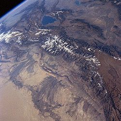
The Tian Shan also spelled Tien Shan, is a large mountain system located in Central Asia
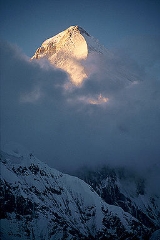
. The highest peak in the Tian Shan is Victory Peak (Jengish Chokusu), 7439 metres (24,406 ft).
The Chinese name for Tian Shan may be derived from the Xiongnu
name qilian
, which was descried by the Shiji as the homeland of the Yuezhi
, and has been said to refer to the Tian Shan rather than to the range 1500 kilometres (932.1 mi) further east now known by this name. The nearby Tannu-Ola Mountains
(Tuvan
: Таңды-Уула Tangdy-Uula) bear the same name ("heaven/celestial mountains" or "god/spirit mountains").
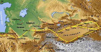
, Kyrgyzstan
and the Xinjiang
Uyghur
Autonomous Region of western China
. In the south it links up with the Pamir Mountains
. It also extends into the Chinese province of Xinjiang
and into the northern areas of Pakistan
, where it joins the Hindu Kush
.
In Western cartography, the eastern end of the Tian Shan is usually understood to be just west of Ürümqi
, while the range to the east of that city is known as the Bogda Shan
. In Chinese cartography from the Han Dynasty
to the present, however, the Tian Shan also includes the Bogda Shan and Barkol ranges.
 The Tian Shan are a part of the Himalayan
orogenic belt
, which was formed by the collision of the Indian and Eurasian plates
in the Cenozoic
era. They are one of the longest mountain ranges in Central Asia
and stretch some 2800 kilometres (1,739.8 mi) eastward from Tashkent
in Uzbekistan
.
The highest peak in the Tian Shan is Victory Peak (пик Победы in Russian or Jengish Chokusu in Kyrgyz) which, at 7439 metres (24,406 ft), is also the highest point in Kyrgyzstan
and is on the border with China.
The Tian Shan's second highest peak, Khan Tengri
(Lord of the Spirits), straddles the Kazakhstan-Kyrgyzstan border and at 7010 metres (22,998.7 ft) is the highest point of Kazakhstan
. Mountaineers
class these as the two most northerly peaks over 7000 metres (22,965.9 ft) in the world.
The Torugart Pass
, at 3752 metres (12,310 ft), is located at the border between Kyrgyzstan and China's Xinjiang
province. The forested Alatau
ranges, which are at a lower altitude in the northern part of the Tian Shan, are inhabited by pastoral tribes that speak Turkic languages
.
The major rivers rising in the Tian Shan are the Syr Darya
, the Ili River
and the Tarim River
. The Aksu Canyon
is a notable feature in the northwestern Tian Shan.
One of the first Europeans to visit and the first to describe the Tian Shan in detail was the Russian explorer Peter Semenov, who did so in the 1850s.
 In China the Tian Shan starts north of Kumul City (Hami) with the U-shaped Barkol Mountains, from about 600 to 400 km (372.8 to 248.5 ) east of Ürümqi
. Then the Bogda Shan
(god mountains) run from 350 to 40 km (217.5 to 24.9 ) east of Ürümqi. Then there is a low area between Ürümqi and the Turfan Depression
. The Borohoro mountains start just south of Ürümqi and run west northwest 450 kilometres (279.6 mi) separating Dzungaria
from the Ili River
basin. Their north end abuts on the 200 kilometres (124.3 mi) Dzungarian Alatau
which run east northeast along Sino-Kazakh border. They start 50 kilometres (31.1 mi) east of Taldykorgan
in Kazakhstan and end at the Dzungarian Gate
. The Dzungarian Alatau
in north, (name?) in middle and Borohoro range in south make a reversed Z or S, the northeast enclosing part of Dzungaria and the southwest enclosing the upper Ili valley.
 In Kyrgyzstan
the main line of the Tian Shan continues as (name?) from the base of the Borohoros west 570 kilometres (354.2 mi) to the point where China, Kazakhstan and Kyrgyzstan meet. Here is the highest part of the range – the Central Tian Shan, with Peak Pobeda
and Khan Tengri
. West of this, the Tian Shan split into an ‘eye’, with Issyk Kul Lake in its center. The south side of the lake is the Terskey Alatau and the north side the Kyungey Ala-Too
(shady and sunny Ala-Too). North of the Kyungey Ala-Too and parallel to it is the Trans-Ili Alatau
in Kazakhstan just south of Almaty
. West of the eye, the range continues 400 kilometres (248.5 mi) as the Kyrgyz Ala-Too
, separating Chui Province from Naryn Oblast and then Kazakhstan from the Talas Province
. This oblast
is the upper valley of the Talas River
, the south side of which is the 200 kilometres (124.3 mi) Talas Ala-Too Range
('Ala-too' is a Kirgiz spelling of Alatau). At the east end of the Talas Alatau the Suusamyr Too
range runs southeast enclosing the Suusamyr Valley or plateau.
As for the area south of the Fergana Valley
there is a 800 kilometres (497.1 mi) group of mountains that curves west-southwest from south of Issyk Kul Lake separating the Tarim Basin
from the Fergana Valley
. The Fergana Range
runs northeast towards the Talas Ala-Too and separaties the upper Naryn basin from Fergana proper. The southern side of these mountains merge into the Pamirs in Tajikistan (Alay Mountains
and Trans-Alay Range
). West of this is the Turkestan Range
, which continues almost to Samarkand.
(Picea schrenkiana) at altitudes of over 2000 metres (6,561.7 ft); the lower slopes have unique natural forests of wild Walnut
s and Apple
s.
, the Queen Mother of the West is believed to guard the peach
trees of immortality
in the Tian Shan.
Central Asia
Central Asia is a core region of the Asian continent from the Caspian Sea in the west, China in the east, Afghanistan in the south, and Russia in the north...
. The highest peak in the Tian Shan is Victory Peak (Jengish Chokusu), 7439 metres (24,406 ft).
The Chinese name for Tian Shan may be derived from the Xiongnu
Xiongnu
The Xiongnu were ancient nomadic-based people that formed a state or confederation north of the agriculture-based empire of the Han Dynasty. Most of the information on the Xiongnu comes from Chinese sources...
name qilian
Qilian
The Qilian Mountains is a northern outlier of the Kunlun Mountains, forming the border between Qinghai and the Gansu provinces of northern China.-Geography:...
, which was descried by the Shiji as the homeland of the Yuezhi
Yuezhi
The Yuezhi, or Rouzhi , also known as the Da Yuezhi or Da Rouzhi , were an ancient Central Asian people....
, and has been said to refer to the Tian Shan rather than to the range 1500 kilometres (932.1 mi) further east now known by this name. The nearby Tannu-Ola Mountains
Tannu-Ola Mountains
The Tannu-Ola mountains is a mountain range in southern Siberia, in the Tuva Republic of Russia. It extends in an east-west direction and curves along the Mongolian border...
(Tuvan
Tuvan language
Tuvan , also known as Tuvinian, Tyvan or Tuvin, is a Turkic language spoken in the Republic of Tuva in south-central Siberia in Russia. The language has borrowed a great number of roots from the Mongolian language and more recently from the Russian language...
: Таңды-Уула Tangdy-Uula) bear the same name ("heaven/celestial mountains" or "god/spirit mountains").
Geography
Tian Shan lies to the north and west of the Taklamakan Desert in the border region of KazakhstanKazakhstan
Kazakhstan , officially the Republic of Kazakhstan, is a transcontinental country in Central Asia and Eastern Europe. Ranked as the ninth largest country in the world, it is also the world's largest landlocked country; its territory of is greater than Western Europe...
, Kyrgyzstan
Kyrgyzstan
Kyrgyzstan , officially the Kyrgyz Republic is one of the world's six independent Turkic states . Located in Central Asia, landlocked and mountainous, Kyrgyzstan is bordered by Kazakhstan to the north, Uzbekistan to the west, Tajikistan to the southwest and China to the east...
and the Xinjiang
Xinjiang
Xinjiang is an autonomous region of the People's Republic of China. It is the largest Chinese administrative division and spans over 1.6 million km2...
Uyghur
Uyghur people
The Uyghur are a Turkic ethnic group living in Eastern and Central Asia. Today, Uyghurs live primarily in the Xinjiang Uyghur Autonomous Region in the People's Republic of China...
Autonomous Region of western China
China
Chinese civilization may refer to:* China for more general discussion of the country.* Chinese culture* Greater China, the transnational community of ethnic Chinese.* History of China* Sinosphere, the area historically affected by Chinese culture...
. In the south it links up with the Pamir Mountains
Pamir Mountains
The Pamir Mountains are a mountain range in Central Asia formed by the junction or knot of the Himalayas, Tian Shan, Karakoram, Kunlun, and Hindu Kush ranges. They are among the world’s highest mountains and since Victorian times they have been known as the "Roof of the World" a probable...
. It also extends into the Chinese province of Xinjiang
Xinjiang
Xinjiang is an autonomous region of the People's Republic of China. It is the largest Chinese administrative division and spans over 1.6 million km2...
and into the northern areas of Pakistan
Pakistan
Pakistan , officially the Islamic Republic of Pakistan is a sovereign state in South Asia. It has a coastline along the Arabian Sea and the Gulf of Oman in the south and is bordered by Afghanistan and Iran in the west, India in the east and China in the far northeast. In the north, Tajikistan...
, where it joins the Hindu Kush
Hindu Kush
The Hindu Kush is an mountain range that stretches between central Afghanistan and northern Pakistan. The highest point in the Hindu Kush is Tirich Mir in the Chitral region of Khyber-Pakhtunkhwa, Pakistan.It is the westernmost extension of the Pamir Mountains, the Karakoram Range, and is a...
.
In Western cartography, the eastern end of the Tian Shan is usually understood to be just west of Ürümqi
Ürümqi
Ürümqi , formerly Tihwa , is the capital of Xinjiang Uyghur Autonomous Region of the People's Republic of China, in the northwest of the country....
, while the range to the east of that city is known as the Bogda Shan
Bogda Shan
The Bogda Shan range is part of the eastern Tien Shan mountains, and located in Xinjiang, some 60 km east of Ürümqi. The highest elevation is Bogda Feng, at 5445 m....
. In Chinese cartography from the Han Dynasty
Han Dynasty
The Han Dynasty was the second imperial dynasty of China, preceded by the Qin Dynasty and succeeded by the Three Kingdoms . It was founded by the rebel leader Liu Bang, known posthumously as Emperor Gaozu of Han. It was briefly interrupted by the Xin Dynasty of the former regent Wang Mang...
to the present, however, the Tian Shan also includes the Bogda Shan and Barkol ranges.
Himalayas
The Himalaya Range or Himalaya Mountains Sanskrit: Devanagari: हिमालय, literally "abode of snow"), usually called the Himalayas or Himalaya for short, is a mountain range in Asia, separating the Indian subcontinent from the Tibetan Plateau...
orogenic belt
Orogeny
Orogeny refers to forces and events leading to a severe structural deformation of the Earth's crust due to the engagement of tectonic plates. Response to such engagement results in the formation of long tracts of highly deformed rock called orogens or orogenic belts...
, which was formed by the collision of the Indian and Eurasian plates
Plate tectonics
Plate tectonics is a scientific theory that describes the large scale motions of Earth's lithosphere...
in the Cenozoic
Cenozoic
The Cenozoic era is the current and most recent of the three Phanerozoic geological eras and covers the period from 65.5 mya to the present. The era began in the wake of the Cretaceous–Tertiary extinction event at the end of the Cretaceous that saw the demise of the last non-avian dinosaurs and...
era. They are one of the longest mountain ranges in Central Asia
Central Asia
Central Asia is a core region of the Asian continent from the Caspian Sea in the west, China in the east, Afghanistan in the south, and Russia in the north...
and stretch some 2800 kilometres (1,739.8 mi) eastward from Tashkent
Tashkent
Tashkent is the capital of Uzbekistan and of the Tashkent Province. The officially registered population of the city in 2008 was about 2.2 million. Unofficial sources estimate the actual population may be as much as 4.45 million.-Early Islamic History:...
in Uzbekistan
Uzbekistan
Uzbekistan , officially the Republic of Uzbekistan is a doubly landlocked country in Central Asia and one of the six independent Turkic states. It shares borders with Kazakhstan to the west and to the north, Kyrgyzstan and Tajikistan to the east, and Afghanistan and Turkmenistan to the south....
.
The highest peak in the Tian Shan is Victory Peak (пик Победы in Russian or Jengish Chokusu in Kyrgyz) which, at 7439 metres (24,406 ft), is also the highest point in Kyrgyzstan
Geography of Kyrgyzstan
Kyrgyzstan is a landlocked nation in Central Asia, west of the People's Republic of China. Less than a seventh the size of Mongolia, at 199,951 square kilometers, Kyrgyzstan is one of the smaller Central Asian states...
and is on the border with China.
The Tian Shan's second highest peak, Khan Tengri
Khan Tengri
Khan Tengri is a mountain of the Tian Shan mountain range. It is located on the China—Kyrgyzstan—Kazakhstan border, east of lake Issyk Kul. Its geologic elevation is , but its glacial cap rises to...
(Lord of the Spirits), straddles the Kazakhstan-Kyrgyzstan border and at 7010 metres (22,998.7 ft) is the highest point of Kazakhstan
Geography of Kazakhstan
Kazakhstan is located in Central Asia and Eastern Europe. With an area of about 2,717,300 square kilometers, Kazakhstan is more than twice the combined size of the other four Central Asian states, or about twice the size of Alaska...
. Mountaineers
Mountaineering
Mountaineering or mountain climbing is the sport, hobby or profession of hiking, skiing, and climbing mountains. While mountaineering began as attempts to reach the highest point of unclimbed mountains it has branched into specialisations that address different aspects of the mountain and consists...
class these as the two most northerly peaks over 7000 metres (22,965.9 ft) in the world.
The Torugart Pass
Torugart Pass
Torugart Pass is a pass in the Tian Shan mountain range on the border between the Naryn Province of Kyrgyzstan and the Xinjiang Autonomous Region of China.The scenic Lake of Chatyr-Kul lies near the pass on the Kyrgyz side...
, at 3752 metres (12,310 ft), is located at the border between Kyrgyzstan and China's Xinjiang
Xinjiang
Xinjiang is an autonomous region of the People's Republic of China. It is the largest Chinese administrative division and spans over 1.6 million km2...
province. The forested Alatau
Alatau
Alatau or Ala-Too is a generic name for a number of mountain ranges in Central Asia, characterized by interleaving areas of vegetation, scattered rocks and snows.The Alatau Mountains are located in the North East of Kazakhstan...
ranges, which are at a lower altitude in the northern part of the Tian Shan, are inhabited by pastoral tribes that speak Turkic languages
Turkic languages
The Turkic languages constitute a language family of at least thirty five languages, spoken by Turkic peoples across a vast area from Eastern Europe and the Mediterranean to Siberia and Western China, and are considered to be part of the proposed Altaic language family.Turkic languages are spoken...
.
The major rivers rising in the Tian Shan are the Syr Darya
Syr Darya
The Syr Darya , also transliterated Syrdarya or Sirdaryo, is a river in Central Asia, sometimes known as the Jaxartes or Yaxartes from its Ancient Greek name . The Greek name is derived from Old Persian, Yakhsha Arta , a reference to the color of the river's water...
, the Ili River
Ili River
thumb|right|300px|Map of the Lake Balkhash drainage basin showing the Ili River and its tributariesThe Ili River is a river in northwestern China and southeastern Kazakhstan .It is long, of which is in Kazakhstan...
and the Tarim River
Tarim River
The Tarim River is the principal river of the Xinjiang Uygur Autonomous Region in the People's Republic of China...
. The Aksu Canyon
Aksu Canyon
Aksu Canyon is 15 km long and 500m deep canyon in Kazakhstan. It is situated in the northwest of the Tian Shan mountain range 200 km northeast of Tashkent. It has an alpine character with nearby mountains reaching over 4000m. The Aksu-Djabagly Nature Reserve, though relatively small in...
is a notable feature in the northwestern Tian Shan.
One of the first Europeans to visit and the first to describe the Tian Shan in detail was the Russian explorer Peter Semenov, who did so in the 1850s.
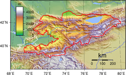
Ranges of the Tian Shan
The Tian Shan have a number of named ranges which are often mentioned separately. (all distances are approximate)Ürümqi
Ürümqi , formerly Tihwa , is the capital of Xinjiang Uyghur Autonomous Region of the People's Republic of China, in the northwest of the country....
. Then the Bogda Shan
Bogda Shan
The Bogda Shan range is part of the eastern Tien Shan mountains, and located in Xinjiang, some 60 km east of Ürümqi. The highest elevation is Bogda Feng, at 5445 m....
(god mountains) run from 350 to 40 km (217.5 to 24.9 ) east of Ürümqi. Then there is a low area between Ürümqi and the Turfan Depression
Turfan Depression
The Turpan Depression or Turfan Depression is a fault-bounded trough located around and south of the city-oasis of Turpan, in the Xinjiang Autonomous Region in far western China, about 150 km southeast of the provincial capital Ürümqi. It includes the third lowest exposed point on the Earth's...
. The Borohoro mountains start just south of Ürümqi and run west northwest 450 kilometres (279.6 mi) separating Dzungaria
Dzungaria
Dzungaria, also called Zungaria, is a geographical region in northwest China corresponding to the northern half of Xinjiang. It covers approximately , lying mostly within Xinjiang, and extending into western Mongolia and eastern Kazakhstan...
from the Ili River
Ili River
thumb|right|300px|Map of the Lake Balkhash drainage basin showing the Ili River and its tributariesThe Ili River is a river in northwestern China and southeastern Kazakhstan .It is long, of which is in Kazakhstan...
basin. Their north end abuts on the 200 kilometres (124.3 mi) Dzungarian Alatau
Dzungarian Alatau
The Dzungarian Alatau is a mountain range that lies on the boundary of Xinjiang region of China and Kazakhstan. The range is named after Dzungaria. Length: cca...
which run east northeast along Sino-Kazakh border. They start 50 kilometres (31.1 mi) east of Taldykorgan
Taldykorgan
Taldykorgan , formerly known as Taldy-Kurgan , is the administrative center of Almaty Province, Kazakhstan. It has a population of 118,400 . Most of the people are Kazakhs.-Education:...
in Kazakhstan and end at the Dzungarian Gate
Dzungarian Gate
The Dzungarian Gate is a geographically and historically significant mountain pass between China and Central Asia. It has been described as the "one and only gateway in the mountain-wall which stretches from Manchuria to Afghanistan, over a distance of three thousand miles." Given its association...
. The Dzungarian Alatau
Dzungarian Alatau
The Dzungarian Alatau is a mountain range that lies on the boundary of Xinjiang region of China and Kazakhstan. The range is named after Dzungaria. Length: cca...
in north, (name?) in middle and Borohoro range in south make a reversed Z or S, the northeast enclosing part of Dzungaria and the southwest enclosing the upper Ili valley.
Kyrgyzstan
Kyrgyzstan , officially the Kyrgyz Republic is one of the world's six independent Turkic states . Located in Central Asia, landlocked and mountainous, Kyrgyzstan is bordered by Kazakhstan to the north, Uzbekistan to the west, Tajikistan to the southwest and China to the east...
the main line of the Tian Shan continues as (name?) from the base of the Borohoros west 570 kilometres (354.2 mi) to the point where China, Kazakhstan and Kyrgyzstan meet. Here is the highest part of the range – the Central Tian Shan, with Peak Pobeda
Peak Pobeda
Jengish Chokusu is the highest mountain in the Tian Shan mountain system at . It lies on the Kyrgyzstan-China border, in the Kakshaal Too, the highest part of the Tien Shan, southeast of lake Issyk Kul.- Names :...
and Khan Tengri
Khan Tengri
Khan Tengri is a mountain of the Tian Shan mountain range. It is located on the China—Kyrgyzstan—Kazakhstan border, east of lake Issyk Kul. Its geologic elevation is , but its glacial cap rises to...
. West of this, the Tian Shan split into an ‘eye’, with Issyk Kul Lake in its center. The south side of the lake is the Terskey Alatau and the north side the Kyungey Ala-Too
Kyungey Ala-Too
The Kyungey Ala-Too or Kyungei Alatoo, Kungey Ala-Too, Kungey Alatau is a range in the North Tien-Shan. Its length is about 280 km and it stretches from Boom Gorge to Kegen - Karkyrin valley. The highest point of the range is Peak Chok Tal ....
(shady and sunny Ala-Too). North of the Kyungey Ala-Too and parallel to it is the Trans-Ili Alatau
Trans-Ili Alatau
Trans-Ili Alatau , , also spelt as Zailiyski Alatau, Zailiysk Alatau, etc., is a part of the Northern Tian Shan mountain system in Kazakhstan and Kyrgyzstan. It is the northernmost mountain range of Tian Shan stretching for about 350 km with maximal elevation of 4,973m . The term "Alatau" refers...
in Kazakhstan just south of Almaty
Almaty
Almaty , also known by its former names Verny and Alma-Ata , is the former capital of Kazakhstan and the nation's largest city, with a population of 1,348,500...
. West of the eye, the range continues 400 kilometres (248.5 mi) as the Kyrgyz Ala-Too
Kyrgyz Ala-Too
The Kyrgyz Ala-Too is a large range in the North Tien-Shan. It stretches for a total length of 454 km from the west-end of Issyk-Kul to the town Taraz in Kazakhstan. It runs in the east-west direction, separating Chuy Valley from Kochkor Valley, Suusamyr Valley, and Talas Valley. Talas Ala-Too...
, separating Chui Province from Naryn Oblast and then Kazakhstan from the Talas Province
Talas Province
Talas Province is a province of Kyrgyzstan. Its capital is Talas. It is bordered on the west and north by Jambyl Province of Kazakhstan, on the east by Chui Province, on the south by Jalal-Abad Province and on the southwest by a finger of Uzbekistan. It is basically a U-shaped valley open to the...
. This oblast
Oblast
Oblast is a type of administrative division in Slavic countries, including some countries of the former Soviet Union. The word "oblast" is a loanword in English, but it is nevertheless often translated as "area", "zone", "province", or "region"...
is the upper valley of the Talas River
Talas River
The Talas River rises in the Talas Province of Kyrgyzstan and flows west into Kazakhstan. It is formed from the confluence of the Karakol and Uch-Koshoy...
, the south side of which is the 200 kilometres (124.3 mi) Talas Ala-Too Range
Talas Ala-Too Range
The Talas Ala-Too range is range of the Tian Shan mountains forming the southern and eastern border of Talas Province of Kyrgyzstan. Its western end extends into Kazakhstan, and its southwestern end joins the Pskem Mountains of Uzbekistan. Its eastern end joins the Kirgiz Alatau mountains...
('Ala-too' is a Kirgiz spelling of Alatau). At the east end of the Talas Alatau the Suusamyr Too
Suusamyr Too
Suusamyr Too is a mountain range in internal Tian Shan in Kyrgyz Republic. It separates Suusamyr Valley and Toluk Saragat Valley. The length of the range is 126 km, and height up to 4048m. It is composed of granite, and schist of lower Paleozoic....
range runs southeast enclosing the Suusamyr Valley or plateau.
As for the area south of the Fergana Valley
Fergana Valley
The Fergana Valley or Farghana Valley is a region in Central Asia spreading across eastern Uzbekistan, Kyrgyzstan and Tajikistan. Divided across three subdivisions of the former Soviet Union, the valley is ethnically diverse, and in the early 21st century was the scene of ethnic conflict...
there is a 800 kilometres (497.1 mi) group of mountains that curves west-southwest from south of Issyk Kul Lake separating the Tarim Basin
Tarim Basin
The Tarim Basin is a large endorheic basin occupying an area of about . It is located in the Xinjiang Uyghur Autonomous Region in China's far west. Its northern boundary is the Tian Shan mountain range and its southern is the Kunlun Mountains on the northern edge of the Tibetan Plateau. The...
from the Fergana Valley
Fergana Valley
The Fergana Valley or Farghana Valley is a region in Central Asia spreading across eastern Uzbekistan, Kyrgyzstan and Tajikistan. Divided across three subdivisions of the former Soviet Union, the valley is ethnically diverse, and in the early 21st century was the scene of ethnic conflict...
. The Fergana Range
Fergana Range
Fergana Range is a mountain range in Tian Shan in Kyrgyz Republic. The length of the range is 206 km, height up to 4893 m, and average height - 3600 m above sea level.-Geography:...
runs northeast towards the Talas Ala-Too and separaties the upper Naryn basin from Fergana proper. The southern side of these mountains merge into the Pamirs in Tajikistan (Alay Mountains
Alay Mountains
The Alay or Alai Mountains is a mountain range that extends from the Tien Shan mountain range in Kyrgyzstan west into Tajikistan. It is part of the Pamir-Alay mountain system. The range runs approximately east to west. Its highest summit is Pik Tandykul , 5544 m. The southern slopes of the range...
and Trans-Alay Range
Trans-Alay Range
The Trans-Alay Range is the northernmost range of the Pamir Mountains , where the Pamirs and the Tian Shan come together. They form the border between Osh Province, Kyrgyzstan and Gorno-Badakshan province, Tajikistan. To the north is the Alay Valley and to the south, the Muksu River. The highest...
). West of this is the Turkestan Range
Turkestan Range
One of the westernmost extensions of the massive Tian Shan system, the Turkestan Range stretches for a total length of 340 km from the Alay Mountains on the border of Kyrgyzstan with Tajikistan to the Samarkand oasis in Uzbekistan...
, which continues almost to Samarkand.
Ecology
The Tian Shan holds important forests of Schrenk's SpruceSchrenk's Spruce
Schrenk's Spruce, Picea schrenkiana, is a spruce native to the Tian Shan mountains of central Asia in western China , Kazakhstan, Kyrgyzstan and Northern Pakistan. It grows at altitudes of 1,300-3,600 metres, usually in pure forests, sometimes mixed with the Tien Shan variety of Siberian Fir...
(Picea schrenkiana) at altitudes of over 2000 metres (6,561.7 ft); the lower slopes have unique natural forests of wild Walnut
Persian Walnut
Juglans regia, the Persian walnut, English walnut, or especially in Great Britain, Common walnut, is an Old World walnut tree species native to the region stretching from the Balkans eastward to the Himalayas and southwest China...
s and Apple
Apple
The apple is the pomaceous fruit of the apple tree, species Malus domestica in the rose family . It is one of the most widely cultivated tree fruits, and the most widely known of the many members of genus Malus that are used by humans. Apple grow on small, deciduous trees that blossom in the spring...
s.
Chinese religion
In Daoism Xi WangmuXi Wangmu
Xi Wangmu, literally Queen Mother of the West , is an ancient Chinese goddess, also known in Japan and Korea. Her origins can be traced back to oracle bone inscriptions of the 15th century BCE that record sacrifices to a "western mother". Even though these inscriptions illustrate that she predates...
, the Queen Mother of the West is believed to guard the peach
Peach
The peach tree is a deciduous tree growing to tall and 6 in. in diameter, belonging to the subfamily Prunoideae of the family Rosaceae. It bears an edible juicy fruit called a peach...
trees of immortality
Immortality
Immortality is the ability to live forever. It is unknown whether human physical immortality is an achievable condition. Biological forms have inherent limitations which may or may not be able to be overcome through medical interventions or engineering...
in the Tian Shan.
External links
- Russian mountaineering site
- Tien Shan
- United Nations University (2009) digital video "Finding a place to feed: Kyrgyz shepherds & pasture loss": Shepherd shares family's observations and adaptation to the changing climate in highland pastures of Kyrgyzstan's Tian Shan mountains Accessed 1 December 2009