

Leh District
Encyclopedia
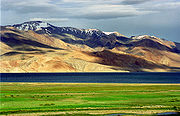
Ladakh
Ladakh is a region of Jammu and Kashmir, the northernmost state of the Republic of India. It lies between the Kunlun mountain range in the north and the main Great Himalayas to the south, inhabited by people of Indo-Aryan and Tibetan descent...
, the other being the Kargil District
Kargil District
Kargil is a district of Ladakh, Kashmir, India. Kargil lies near the Line of Control facing Pakistan-occupied Kashmir's Baltistan to the west, and Kashmir valley to the south. Zanskar is part of Kargil district along with Suru, Wakha and Dras valleys...
to the west, in the state of Jammu and Kashmir
Jammu and Kashmir
Jammu and Kashmir is the northernmost state of India. It is situated mostly in the Himalayan mountains. Jammu and Kashmir shares a border with the states of Himachal Pradesh and Punjab to the south and internationally with the People's Republic of China to the north and east and the...
, India
India
India , officially the Republic of India , is a country in South Asia. It is the seventh-largest country by geographical area, the second-most populous country with over 1.2 billion people, and the most populous democracy in the world...
. It is the second largest district in India in terms of area. It is bounded on the north by Ghanche District (Gilgit-Baltistan), a small border with Xinjiang
Xinjiang
Xinjiang is an autonomous region of the People's Republic of China. It is the largest Chinese administrative division and spans over 1.6 million km2...
, China, via the Karakoram Pass
Karakoram Pass
The Karakoram Pass is a mountain pass between India and China in the Karakoram Range. It is the highest pass on the ancient caravan route between Leh in Ladakh and Yarkand in the Tarim Basin...
which is part of the district. Aksai Chin
Aksai Chin
Aksai Chin is one of the two main disputed border areas between China and India, and the other is South Tibet, which comprises most of India's Arunachal Pradesh. It is administered by China as part of Hotan County in the Hotan Prefecture of Xinjiang Autonomous Region, but is also claimed by India...
and Tibet
Tibet
Tibet is a plateau region in Asia, north-east of the Himalayas. It is the traditional homeland of the Tibetan people as well as some other ethnic groups such as Monpas, Qiang, and Lhobas, and is now also inhabited by considerable numbers of Han and Hui people...
are to the east, Kargil district
Kargil District
Kargil is a district of Ladakh, Kashmir, India. Kargil lies near the Line of Control facing Pakistan-occupied Kashmir's Baltistan to the west, and Kashmir valley to the south. Zanskar is part of Kargil district along with Suru, Wakha and Dras valleys...
to the west, and Lahul and Spiti
Lahul and Spiti
The district of Lahaul-Spiti in the Indian state of Himachal Pradesh consists of the two formerly separate districts of Lahaul and Spiti. The present administrative centre is Keylong in Lahaul...
to the south. The district headquarters is based in Leh. It lies between 32
32nd parallel north
The 32nd parallel north is a circle of latitude that is 32 degrees north of the Earth's equatorial plane. It crosses Africa, Asia, the Pacific Ocean, North America and the Atlantic Ocean....
to 36 degree
36th parallel north
The 36th parallel north is a circle of latitude that is 36 degrees north of the Earth's equatorial plane. It crosses Africa, the Mediterranean Sea, Asia, the Pacific Ocean, North America and the Atlantic Ocean....
north latitude and 75
75th meridian east
The meridian 75° east of Greenwich is a line of longitude that extends from the North Pole across the Arctic Ocean, Asia, the Indian Ocean, the Southern Ocean, and Antarctica to the South Pole....
to 80 degree
80th meridian east
The meridian 80° east of Greenwich is a line of longitude that extends from the North Pole across the Arctic Ocean, Asia, the Indian Ocean, the Southern Ocean, and Antarctica to the South Pole....
east longitude.
The whole of Ladakh was under the administration of Leh until July 1, 1979, when the Kargil and Ladakh administrative districts were created. Religion has been a source of grievances between Buddhists and Muslims since the late 20th century and was a contributor to this division.
As of 2011 it is the second least populous district of Jammu and Kashmir (out of 22), after Kargil
Kargil District
Kargil is a district of Ladakh, Kashmir, India. Kargil lies near the Line of Control facing Pakistan-occupied Kashmir's Baltistan to the west, and Kashmir valley to the south. Zanskar is part of Kargil district along with Suru, Wakha and Dras valleys...
.
Demographics
According to the 2011 census2011 census of India
The 15th Indian National census was conducted in two phases, houselisting and population enumeration. Houselisting phase began on April 1, 2010 and involved collection of information about all buildings...
has a population
Demographics of India
The demographics of India are inclusive of the second most populous country in the world, with over 1.21 billion people , more than a sixth of the world's population. Already containing 17.5% of the world's population, India is projected to be the world's most populous country by 2025, surpassing...
of 147,104 , roughly equal to the nation of Saint Lucia
Saint Lucia
Saint Lucia is an island country in the eastern Caribbean Sea on the boundary with the Atlantic Ocean. Part of the Lesser Antilles, it is located north/northeast of the island of Saint Vincent, northwest of Barbados and south of Martinique. It covers a land area of 620 km2 and has an...
. This gives it a ranking of 599th in India (out of a total of 640
Districts of India
A district is an administrative division of an Indian state or territory. Districts are further subdivided, in some cases into Sub-Divisions, and otherwise directly into tehsils or talukas.District officials include:...
). The district has a population density of 3 PD/sqkm . Its population growth rate
Family planning in India
Family planning in India is based on efforts largely sponsored by the Indian government. In the 1965-2009 period, contraceptive usage has more than tripled and the fertility rate has more than halved , but the national fertility rate is still high enough to cause long-term population growth...
over the decade 2001-2011 was 25.48 %. Leh has a sex ratio
Sex ratio
Sex ratio is the ratio of males to females in a population. The primary sex ratio is the ratio at the time of conception, secondary sex ratio is the ratio at time of birth, and tertiary sex ratio is the ratio of mature organisms....
of 583 females
Women in India
The status of women in India has been subject to many great changes over the past few millennia. From equal status with men in ancient times through the low points of the medieval period, to the promotion of equal rights by many reformers, the history of women in India has been eventful...
for every 1000 males, and a literacy rate
Literacy in India
Literacy in India is key for socio-economic progress, and the Indian literacy rate grew to 74.04% in 2011 from 12% at the end of British rule in 1947. Although this was a greater than sixfold improvement, the level is well below the world average literacy rate of 84%, and India currently has the...
of 80.48 %.
According to the 2001 census of India, Leh district had a population of 117,232. Buddhists made up the majority at 77.3%, followed by Muslims at 13.8% and then Hindus at 8.2%.
Administration
Leh district consists of nine blocks: NubraNubra
Nubra may refer to:In the Indian subcontinent:* Nubra Valley, in the Jammu and Kashmir region* Nubra River, in the Jammu and Kashmir region* Nubra Pika , a mammalOther:* NuBra, a strapless brassiere...
, Panamik, Khalsi (Khaltse), Saspol, Leh, Chuchot, Kharu, Durbuk
Durbuk
Durbuk is a village that falls under the Ladhak region of Jammu and Kashmir state in India.Also called as Durbuk Laga, this village is located at an altitude of 13,500 feet above sea level...
, and Nyoma
Nyoma
Nyoma Rap or Nyama is a town in Leh District, Jammu and Kashmir in northern India. There is an Advanced Landing Ground of Indian Airforce, which is proposed to be reactivated. An AN 32 landed in this airfield after which it was opened in 18 September 2009. Nearby towns are Mahe and Rupshu, the...
. Each block consists of a number of panchayats.
The district of Leh is subdivided into six tehsils:
- Nubra Tehsil
- Khalsi Tehsil
- Leh Tehsil
- Kharu Tehsil
- Durubk Tehsil
- Nyoma Tehsil
Autonomous Hill Council
Leh District is administered by an elected body known as the Ladakh Autonomous Hill Development Council, Leh. The LAHDC was established in 1995.External links
- Official Website of Ladakh Autonomous Hill Development Council, Leh
- Leh district profile
- Ladakhi food
- Border Area Development
- The Ladakh Region
- Ladakh Tourism Guide - Photo Gallery of Leh, Monasteries in Leh, NGO’s in Leh, Important Phone #.