

Kumtag Desert
Encyclopedia
The Kumtag Desert, Kumtagh Desert or Desert of Kum-tag ( Turkish
:Kumdağ), literally "sand mountain desert" in Old Turkic
language (Kum meaning sand and Tag meaning Mountain), is an arid landform in Northwestern China
, which was proclaimed as a national park
in the year 2002.
with its central Taklamakan Desert is bounded on the north, west and south by mountains. On the east side the Kumtag is an unbroken plain about 100 miles from north to south that runs from the Taklamakan to Gansu
and Mongolia. Many modern maps do not show a Kumtag in this sense which implies that the usage may be out of date.
The Kumtag Desert is a section of the Taklamakan Desert which lies east-southeast of the Desert of Lop. It is on the other side of the Kara-koshun and reaches north-eastwards as far as the vicinity of the town of Sa-chow and the lake of Kara-nor, or Kala-chi. It is bordered by Dunhuang
in the east, Tian Shan
in the north, and with an area of 22,800+ square kilometers. Its southern rim is marked by a labyrinth of hills, dotted in groups and irregular clusters,worn down as it were to mere fragments of their former skeletal structure. Between these and the Altyn-Tagh
, intervenes a broad latitudinal valley, seamed with watercourses that come down from the foothills of the Altyn-tagh. Beside these scrubby desert plants of the usual character maintain a precarious existence. Water reaching them in some instances at intervals of years only. This part of the desert has a general slope northwest towards the relative depression of the Kara-koshun. A noticeable feature of the Kum-tagh is the presence of large accumulations of drift-sand, especially along the foot of the crumbling desert ranges, where it rises into dunes sometimes as much as 250 feet (76.2 m) in height and climbs half-way up the flanks of ranges themselves.
Administratively, the desert is located in the Ruoqiang (Qakilik) County
of Xinjiang and Aksai Kazakh Autonomous County
and Dunhuang
City of Gansu
, near their border with Qinghai
.
 2. Narrow Definition: A map published by the National Geographic Society shows a much smaller Kumtag. This is a rectangle with a northwest corner south of Lop Nor, a southern edge along the Altyn-Tagh
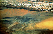
and an eastern edge just beyond the Gansu border. Near the northeast corner is the Jade Gate
which is often taken as the eastern end of the Great Wall. From space it appears as a belt of orange sand dunes. This is probably the 2500 square kilometer area mentioned below.
The Kumtag Desert is continuing a process of expansion that is the result of centuries of overgrazing of this region that is beyond its carrying capacity. According to the AFP news report of November, 2007: "Towering sand dunes [of the Kumtag Desert] loom over the ancient Chinese city of Dunhuang
". According to Hogan: "Rapid expansion of the Kumtag Desert and other dunes formations threaten to engulf Yungang and other archaeological sites"; moreover, the desertification adjacent to the Kumtag Desert is part of a larger problem in northern China where the present rate of desertification in this single region of China (e.g. Northern China) now exceeds 1000 square miles (2,590 km²) per annum. To mitigate the desertification, the town of Dunhuang has placed severe limitations on immigration
, and has also placed restrictions on new water-well development or new farm additions.
the sand is heaped up in greater mass on the south, all along the bordering mountain ranges where the floor of the depressions lies at the highest level. The country to the north of the desert ranges is thus summarily described by Sven Hedin: "The first zone of drift sand is succeeded by a region that exhibits proofs of wind modelling on an extraordinarily energetic and well-developed scale, the results corresponding to the jardangs and the wind-eroded
gullies of the Desert of Lop. Both sets of phenomena lie parallel to one another; from this we may infer that the winds which prevail in the two deserts are the same. Next comes, sharply demarcated from the zone just described, a more or less thin kamish steppe
growing on level ground; and this in turn is followed by another very narrow belt of sand
, immediately south of Achik-kuduk Finally in the extreme north we have the characteristic and sharply defined belt of kamish steppe, stretching from eastnortheast to westsouthwest and bounded on north and south by high, sharp cut clay terraces.
"At the points where we measured them the northern terrace was 113 feet (34.4 m) high and the southern 853/4 feet....Both terraces belong to the same level, and would appear to correspond to the shore lines of a big bay of the last surviving remnant of the Central Asian Mediterranean. At the point where I crossed it the depression was 6 to 7 miles (11.3 km), wide, and thus resembled a flat valley or immense river-bed."
Turkish language
Turkish is a language spoken as a native language by over 83 million people worldwide, making it the most commonly spoken of the Turkic languages. Its speakers are located predominantly in Turkey and Northern Cyprus with smaller groups in Iraq, Greece, Bulgaria, the Republic of Macedonia, Kosovo,...
:Kumdağ), literally "sand mountain desert" in Old Turkic
Turkic languages
The Turkic languages constitute a language family of at least thirty five languages, spoken by Turkic peoples across a vast area from Eastern Europe and the Mediterranean to Siberia and Western China, and are considered to be part of the proposed Altaic language family.Turkic languages are spoken...
language (Kum meaning sand and Tag meaning Mountain), is an arid landform in Northwestern China
Northwestern China
Northwestern China includes the autonomous regions of Xinjiang and Ningxia and the provinces of Shaanxi, Gansu, and Qinghai.-Administrative divisions:ProvincesAutonomous Regions-Outer Northwest China:...
, which was proclaimed as a national park
National park
A national park is a reserve of natural, semi-natural, or developed land that a sovereign state declares or owns. Although individual nations designate their own national parks differently A national park is a reserve of natural, semi-natural, or developed land that a sovereign state declares or...
in the year 2002.
Definitions
1. Broad definition: The oval Tarim BasinTarim Basin
The Tarim Basin is a large endorheic basin occupying an area of about . It is located in the Xinjiang Uyghur Autonomous Region in China's far west. Its northern boundary is the Tian Shan mountain range and its southern is the Kunlun Mountains on the northern edge of the Tibetan Plateau. The...
with its central Taklamakan Desert is bounded on the north, west and south by mountains. On the east side the Kumtag is an unbroken plain about 100 miles from north to south that runs from the Taklamakan to Gansu
Gansu
' is a province located in the northwest of the People's Republic of China.It lies between the Tibetan and Huangtu plateaus, and borders Mongolia, Inner Mongolia, and Ningxia to the north, Xinjiang and Qinghai to the west, Sichuan to the south, and Shaanxi to the east...
and Mongolia. Many modern maps do not show a Kumtag in this sense which implies that the usage may be out of date.
The Kumtag Desert is a section of the Taklamakan Desert which lies east-southeast of the Desert of Lop. It is on the other side of the Kara-koshun and reaches north-eastwards as far as the vicinity of the town of Sa-chow and the lake of Kara-nor, or Kala-chi. It is bordered by Dunhuang
Dunhuang
Dunhuang is a city in northwestern Gansu province, Western China. It was a major stop on the ancient Silk Road. It was also known at times as Shāzhōu , or 'City of Sands', a name still used today...
in the east, Tian Shan
Tian Shan
The Tian Shan , also spelled Tien Shan, is a large mountain system located in Central Asia. The highest peak in the Tian Shan is Victory Peak , ....
in the north, and with an area of 22,800+ square kilometers. Its southern rim is marked by a labyrinth of hills, dotted in groups and irregular clusters,worn down as it were to mere fragments of their former skeletal structure. Between these and the Altyn-Tagh
Altyn-Tagh
Altyn-Tagh, Astyn-Tagh, Altun Mountains, Altun Shan or Aerjin Shan Tagh proper is a part of the range south of Lop Nor), is a mountain range in northwestern China that separates the eastern Tarim Basin from the Tibetan Plateau...
, intervenes a broad latitudinal valley, seamed with watercourses that come down from the foothills of the Altyn-tagh. Beside these scrubby desert plants of the usual character maintain a precarious existence. Water reaching them in some instances at intervals of years only. This part of the desert has a general slope northwest towards the relative depression of the Kara-koshun. A noticeable feature of the Kum-tagh is the presence of large accumulations of drift-sand, especially along the foot of the crumbling desert ranges, where it rises into dunes sometimes as much as 250 feet (76.2 m) in height and climbs half-way up the flanks of ranges themselves.
Administratively, the desert is located in the Ruoqiang (Qakilik) County
Ruoqiang County
Ruoqiang is a county of the Xinjiang Uyghur Autonomous Region in Western China and is under the administration of the Bayingolin Mongol Autonomous Prefecture...
of Xinjiang and Aksai Kazakh Autonomous County
Aksai Kazakh Autonomous County
Aksai Kazakh Autonomous County is an autonomous county of Jiuquan in the province of Gansu in the People's Republic of China.It has an area of 31,374 km² and 2004 population of 10,000...
and Dunhuang
Dunhuang
Dunhuang is a city in northwestern Gansu province, Western China. It was a major stop on the ancient Silk Road. It was also known at times as Shāzhōu , or 'City of Sands', a name still used today...
City of Gansu
Gansu
' is a province located in the northwest of the People's Republic of China.It lies between the Tibetan and Huangtu plateaus, and borders Mongolia, Inner Mongolia, and Ningxia to the north, Xinjiang and Qinghai to the west, Sichuan to the south, and Shaanxi to the east...
, near their border with Qinghai
Qinghai
Qinghai ; Oirat Mongolian: ; ; Salar:) is a province of the People's Republic of China, named after Qinghai Lake...
.
Altyn-Tagh
Altyn-Tagh, Astyn-Tagh, Altun Mountains, Altun Shan or Aerjin Shan Tagh proper is a part of the range south of Lop Nor), is a mountain range in northwestern China that separates the eastern Tarim Basin from the Tibetan Plateau...
and an eastern edge just beyond the Gansu border. Near the northeast corner is the Jade Gate
Jade Gate
Yumen Pass , or Jade Gate or Pass of the Jade Gate, is the name of a pass located west of Dunhuang in today's Gansu Province of China. In ancient times, this was a pass through which the Silk Road passed, and was the one road connecting Central Asia and China, the former called the Western Regions...
which is often taken as the eastern end of the Great Wall. From space it appears as a belt of orange sand dunes. This is probably the 2500 square kilometer area mentioned below.
Ongoing desertification
The Kumtag Desert is expanding and threatening to engulf previously productive lands with its arid wasteland character. Several years prior the estimated size of the desert was 2500 square kilometres, but with recent expansion, the Kumtag Desert is already considerably larger as of 2008.The Kumtag Desert is continuing a process of expansion that is the result of centuries of overgrazing of this region that is beyond its carrying capacity. According to the AFP news report of November, 2007: "Towering sand dunes [of the Kumtag Desert] loom over the ancient Chinese city of Dunhuang
Dunhuang
Dunhuang is a city in northwestern Gansu province, Western China. It was a major stop on the ancient Silk Road. It was also known at times as Shāzhōu , or 'City of Sands', a name still used today...
". According to Hogan: "Rapid expansion of the Kumtag Desert and other dunes formations threaten to engulf Yungang and other archaeological sites"; moreover, the desertification adjacent to the Kumtag Desert is part of a larger problem in northern China where the present rate of desertification in this single region of China (e.g. Northern China) now exceeds 1000 square miles (2,590 km²) per annum. To mitigate the desertification, the town of Dunhuang has placed severe limitations on immigration
Immigration reduction
Immigration reduction refers to a movement in the United States that advocates a reduction in the amount of immigration allowed into the country. Steps advocated for reducing the numbers of immigrants include advocating stronger action to prevent illegal entry and illegal immigration, and...
, and has also placed restrictions on new water-well development or new farm additions.
Prevailing winds and sands
The prevailing winds in this region would appear to blow from the west and northwest during the summer, winter and autumn. Though in spring, when they certainly are more violent, they no doubt come from the northeast, as in the desert of Lop. The arrangement of the sand here agrees perfectly with the law laid down by Potanin, that in the basins of Central AsiaCentral Asia
Central Asia is a core region of the Asian continent from the Caspian Sea in the west, China in the east, Afghanistan in the south, and Russia in the north...
the sand is heaped up in greater mass on the south, all along the bordering mountain ranges where the floor of the depressions lies at the highest level. The country to the north of the desert ranges is thus summarily described by Sven Hedin: "The first zone of drift sand is succeeded by a region that exhibits proofs of wind modelling on an extraordinarily energetic and well-developed scale, the results corresponding to the jardangs and the wind-eroded
Erosion
Erosion is when materials are removed from the surface and changed into something else. It only works by hydraulic actions and transport of solids in the natural environment, and leads to the deposition of these materials elsewhere...
gullies of the Desert of Lop. Both sets of phenomena lie parallel to one another; from this we may infer that the winds which prevail in the two deserts are the same. Next comes, sharply demarcated from the zone just described, a more or less thin kamish steppe
Steppe
In physical geography, steppe is an ecoregion, in the montane grasslands and shrublands and temperate grasslands, savannas, and shrublands biomes, characterized by grassland plains without trees apart from those near rivers and lakes...
growing on level ground; and this in turn is followed by another very narrow belt of sand
Sand
Sand is a naturally occurring granular material composed of finely divided rock and mineral particles.The composition of sand is highly variable, depending on the local rock sources and conditions, but the most common constituent of sand in inland continental settings and non-tropical coastal...
, immediately south of Achik-kuduk Finally in the extreme north we have the characteristic and sharply defined belt of kamish steppe, stretching from eastnortheast to westsouthwest and bounded on north and south by high, sharp cut clay terraces.
"At the points where we measured them the northern terrace was 113 feet (34.4 m) high and the southern 853/4 feet....Both terraces belong to the same level, and would appear to correspond to the shore lines of a big bay of the last surviving remnant of the Central Asian Mediterranean. At the point where I crossed it the depression was 6 to 7 miles (11.3 km), wide, and thus resembled a flat valley or immense river-bed."