
Khunjerab Pass
Encyclopedia
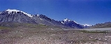
Khunjerab Pass is a high mountain pass
Mountain pass
A mountain pass is a route through a mountain range or over a ridge. If following the lowest possible route, a pass is locally the highest point on that route...
in the Karakoram Mountains in a strategic position on the northern border of Pakistan's
Pakistan
Pakistan , officially the Islamic Republic of Pakistan is a sovereign state in South Asia. It has a coastline along the Arabian Sea and the Gulf of Oman in the south and is bordered by Afghanistan and Iran in the west, India in the east and China in the far northeast. In the north, Tajikistan...
Gilgit-Baltistan region within the disputed region of Kashmir
Kashmir
Kashmir is the northwestern region of the Indian subcontinent. Until the mid-19th century, the term Kashmir geographically denoted only the valley between the Great Himalayas and the Pir Panjal mountain range...
and on the southwest border of the Xinjiang
Xinjiang
Xinjiang is an autonomous region of the People's Republic of China. It is the largest Chinese administrative division and spans over 1.6 million km2...
region of China
People's Republic of China
China , officially the People's Republic of China , is the most populous country in the world, with over 1.3 billion citizens. Located in East Asia, the country covers approximately 9.6 million square kilometres...
. Its name is derived from Wakhi
Wakhi language
Wakhi is an Indo-European language in the branch of Eastern Iranian language family and is intimately related to other Southeastern Iranian languages in the Pamir languages group.-Classification and Distribution:...
for Blood Valley.
Sino-Pakistani Border Crossing
The Khunjerab Pass is the highest paved international border crossing in the world and the highest point on the Karakoram HighwayKarakoram Highway
The Karakoram Highway is the highest paved international road in the world, but at its peak at the China-Pakistan border it is only paved on the Chinese side. It connects China and Pakistan across the Karakoram mountain range, through the Khunjerab Pass, at an altitude of as confirmed by both...
. The roadway across the pass was completed in 1982, and has superseded the unpaved Mintaka
Mintaka Pass
The Mintaka Pass or Mingteke Pass is a mountain pass in the Karakorum Mountains, between Pakistan and Xinjiang in China. In ancient times, the Mintaka Pass and the nearby Kilik Pass , to the west, were the two main access points into the Upper Hunza Valley from the north...
and Kilik
Kilik Pass
The Kilik Pass , to the west of Mintaka Pass is a high mountain pass in the Karakorum Mountains between Pakistan-administered Kashmir and Xinjiang in the People's Republic of China. The two passes were, in ancient times, the two main access points into the Upper Hunza Valley from the north...
Passes as the primary passage across the Karakoram Range.
On the Pakistani side, the pass is 42 km (26.1 mi) from the National Park station and checkpoint in Dih, 75 km (46.6 mi) from the customs and immigration post in Sost
SOST
Sclerostin is a protein that in humans is encoded by the SOST gene.-External links:*-Further reading:...
, 270 km (167.8 mi) from Gilgit
Gilgit
Gilgit is a city in northern PakistanGilgit may refer to other terms related with the area of the city:* Gilgit River* Gilgit Valley* Gilgit District* Gilgit Agency * Gilgit Airport...
, and 870 km (540.6 mi) from Islamabad
Islamabad
Islamabad is the capital of Pakistan and the tenth largest city in the country. Located within the Islamabad Capital Territory , the population of the city has grown from 100,000 in 1951 to 1.7 million in 2011...
.
On the Chinese side, the pass is 130 km (80.8 mi) from Tashkurgan, 420 km (261 mi) from Kashgar
Kashgar
Kashgar or Kashi is an oasis city with approximately 350,000 residents in the western part of the Xinjiang Uyghur Autonomous Region of the People's Republic of China. Kashgar is the administrative centre of Kashgar Prefecture which has an area of 162,000 km² and a population of approximately...
and some 1890 km (1,174.4 mi) from Urumqi
Ürümqi
Ürümqi , formerly Tihwa , is the capital of Xinjiang Uyghur Autonomous Region of the People's Republic of China, in the northwest of the country....
. The Chinese port of entry is located 3.5 km (2.2 mi) along the road from the pass in Tashkurgan County.
The long, relatively flat pass is often snow-covered during the winter season and as a consequence is generally closed from November 30 to May 1. There is excellent grazing on the Chinese side of the pass, and domesticated yaks and dzu
Dzo
A dzo is a hybrid of yak and domestic cattle. The word dzo technically refers to a male hybrid, while a female is known as a dzomo or zhom. Alternative Romanizations of the Tibetan names include zho and zo. In Mongolian it is called khainag...
(a cross between yaks and cows) may be seen from the road.
Since June 1, 2006, there has been a daily bus service across the boundary from Gilgit
Gilgit
Gilgit is a city in northern PakistanGilgit may refer to other terms related with the area of the city:* Gilgit River* Gilgit Valley* Gilgit District* Gilgit Agency * Gilgit Airport...
, to Kashghar, China
People's Republic of China
China , officially the People's Republic of China , is the most populous country in the world, with over 1.3 billion citizens. Located in East Asia, the country covers approximately 9.6 million square kilometres...
Railway
In 2007, consultants were engaged to investigate the construction of a railway through this pass to connect China with transport in Pakistani-administered northern areas of KashmirKashmir
Kashmir is the northwestern region of the Indian subcontinent. Until the mid-19th century, the term Kashmir geographically denoted only the valley between the Great Himalayas and the Pir Panjal mountain range...
. A feasibility study started in November 2009 for a line connecting Havelian
Havelian
Havelian is the second largest municipality in Abbottabad District, in what used to be the Hazara District of the Khyber Pakhtunkhwa of Pakistan.-villages:...
750 km (466 mi) away in Pakistan and Kashgar
Kashgar
Kashgar or Kashi is an oasis city with approximately 350,000 residents in the western part of the Xinjiang Uyghur Autonomous Region of the People's Republic of China. Kashgar is the administrative centre of Kashgar Prefecture which has an area of 162,000 km² and a population of approximately...
350 km (217 mi) in China.
See also
- SostSOSTSclerostin is a protein that in humans is encoded by the SOST gene.-External links:*-Further reading:...
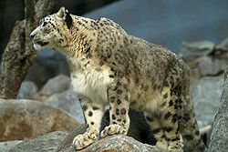
- Khunjerab National ParkKhunjerab National ParkKhunjerab National Park is a National park in Gilgit Baltistan of Pakistan. It is one of the highest altitude parks in the world. It provides the habitat for a number of endangered and threatened animal species like the Snow leopard, Marco Polo sheep, and Himalayan Ibex.The park lies within the...
- Karakoram HighwayKarakoram HighwayThe Karakoram Highway is the highest paved international road in the world, but at its peak at the China-Pakistan border it is only paved on the Chinese side. It connects China and Pakistan across the Karakoram mountain range, through the Khunjerab Pass, at an altitude of as confirmed by both...
- Gilgit-Baltistan
- Nathu LaNathu LaNathu La is a mountain pass in the Himalayas. It connects the Indian state of Sikkim with China's Tibet Autonomous Region. The pass, at 4,310 m above mean sea level, forms a part of an offshoot of the ancient Silk Road. Nathu means "listening ears" and La means "pass" in Tibetan...