

Dunhuang
Encyclopedia
Dunhuang is a city
(pop. 187,578 (2000)) in northwestern Gansu
province, Western China
. It was a major stop on the ancient Silk Road
. It was also known at times as Shāzhōu (沙州), or 'City of Sands', a name still used today. It is best known for the nearby Dunhuang Caves
.
It is situated in a rich oasis
containing Crescent Lake (月牙泉) and Mingsha Shan (鸣沙山, literally "Echoing-Sand Mountain"). Mingsha Shan is so named for the sound of the wind whipping off the dunes, the singing sand
phenomenon.
It commands a very strategic position at the crossroads of the ancient Southern Silk Route and the main road leading from India via Lhasa
to Mongolia
and Southern Siberia
, as well as controlling the entrance to the narrow Gansu Corridor which led straight to the heart of the north Chinese plains and the ancient capitals of Chang'an
(today known as Xi'an) and Luoyang
.
 There is evidence of human habitation in the Dunhuang area as early as 2,000 BC, possibly by people recorded as the Qiang
in Chinese history. Its name was also mentioned as part of the homeland of the Yuezhi
or "Rouzhi" (月氏) in the Shiji (史記), however, if is possible that this mention may refer to an unrelated toponym
, Dunhong
. By the third century BC, the area became dominated by the Xiongnu
, but came under Chinese rule during the Han Dynasty
after Emperor Wu
defeated the Xiongnu
in 121 BC.
Dunhuang was one the frontier garrison
towns established by the Emperor Wu after the defeat of Xiongnu, and the Chinese built fortifications at Dunhuang and sent settlers there. The name Dunhuang, or Blazing Beacon, refers to the beacons lit to warn of attacks by marauding nomadic tribes. Dunhuang Commandery was probably established in 104 BC, or shortly thereafter. Located in the western end of the Hexi Corridor
near the historic junction of the Northern
and Southern Silk Road
s, Dunhuang was a town of military importance.
In later centuries, during the Sui
and Tang
dynasties, it was a major point of communication between ancient China and Central Asia
. By the Tang Dynasty it became the major hub of commerce of the Silk Road. Early Buddhist monk
s arrived at Dunhuang via the ancient Northern Silk Road, the northernmost route of about 2600 kilometres (1,615.6 mi) in length, which connected the ancient Chinese capital of Xi'an
westward over the Wushao Ling Pass to Wuwei and on to Kashgar
. For centuries, Buddhist monks at Dunhuang collected scriptures from the West
, and many pilgrims passed through the area, painting murals inside the Mogao Caves
or "Caves of a Thousand Buddhas." A small number of Christian artifacts
have also been found in the caves (see Jesus Sutras
), testimony to the wide variety of people who made their way along the Silk Road.
As a frontier town, Dunhuang was fought over and occupied at various times by non-Han Chinese nationalities. The Tibetans
occupied Dunhuang when the Tang empire became weakened considerably after the An Lushan Rebellion; even though it was later returned to Tang rule, it was under quasi-autonomous rule by the local general Zhang Yichao
who expelled the Tibetans in 848. After the fall of Tang, Dunhaung was ruled by a local Cao family who formed alliances with the Uighurs and the Kingdom of Khotan
. During the Song Dynasty
, Dunhuang fell outside the Chinese borders. In 1037 it came under the rule of Shazhou Uighurs, then in 1068 the Tanguts who founded the Xi Xia
Dyansty. It was conquered in 1227 by the Mongols
who sacked and destroyed the town, and became part of China again when Kublai Khan
conquered the rest of China. Dunhuang went into a steep decline after the Chinese trade with the outside world became dominated by Southern sea-routes, and the Silk Road was officially abandoned during the Ming Dynasty.
Today, the site is an important tourist attraction and the subject of an ongoing archaeological project. A large number of manuscript
s and artifacts retrieved at Dunhuang have been digitized and made publicly available via the International Dunhuang Project
. The expansion of the Kumtag Desert
, which is resulting from long-standing overgrazing
of surrounding lands, has reached the edges of the city. The city is also the namesake of prominent Chinese e-commerce site DHgate.com
(simplified Chinese: 敦煌网; pinyin: Dūnhuángwǎng).
In 2011, satellite images showing huge structures in the desert near Dunhuang surfaced online and caused a brief media stir.
City
A city is a relatively large and permanent settlement. Although there is no agreement on how a city is distinguished from a town within general English language meanings, many cities have a particular administrative, legal, or historical status based on local law.For example, in the U.S...
(pop. 187,578 (2000)) in northwestern Gansu
Gansu
' is a province located in the northwest of the People's Republic of China.It lies between the Tibetan and Huangtu plateaus, and borders Mongolia, Inner Mongolia, and Ningxia to the north, Xinjiang and Qinghai to the west, Sichuan to the south, and Shaanxi to the east...
province, Western China
Western China
Western China , refers to the western part of China. In the definition of the Chinese government, Western China covers six provinces: Gansu, Guizhou, Qinghai, Shaanxi, Sichuan, and Yunnan; one municipality: Chongqing; and three autonomous regions: Ningxia, Tibet, and Xinjiang.-Administrative...
. It was a major stop on the ancient Silk Road
Silk Road
The Silk Road or Silk Route refers to a historical network of interlinking trade routes across the Afro-Eurasian landmass that connected East, South, and Western Asia with the Mediterranean and European world, as well as parts of North and East Africa...
. It was also known at times as Shāzhōu (沙州), or 'City of Sands', a name still used today. It is best known for the nearby Dunhuang Caves
Mogao Caves
The Mogao Caves or Mogao Grottoes , also known as the Caves of the Thousand Buddhas , form a system of 492 temples southeast of the center of Dunhuang, an oasis strategically located at a religious and cultural crossroads on the Silk Road, in Gansu province, China...
.
It is situated in a rich oasis
Oasis
In geography, an oasis or cienega is an isolated area of vegetation in a desert, typically surrounding a spring or similar water source...
containing Crescent Lake (月牙泉) and Mingsha Shan (鸣沙山, literally "Echoing-Sand Mountain"). Mingsha Shan is so named for the sound of the wind whipping off the dunes, the singing sand
Singing sand
Singing sand, whistling sand or barking sand is sand that produces sound. The sound emission may be caused by wind passing over dunes or by walking on the sand.Certain conditions have to come together to create singing sand:...
phenomenon.
It commands a very strategic position at the crossroads of the ancient Southern Silk Route and the main road leading from India via Lhasa
Lhasa
Lhasa is the administrative capital of the Tibet Autonomous Region in the People's Republic of China and the second most populous city on the Tibetan Plateau, after Xining. At an altitude of , Lhasa is one of the highest cities in the world...
to Mongolia
Mongolia
Mongolia is a landlocked country in East and Central Asia. It is bordered by Russia to the north and China to the south, east and west. Although Mongolia does not share a border with Kazakhstan, its western-most point is only from Kazakhstan's eastern tip. Ulan Bator, the capital and largest...
and Southern Siberia
Siberia
Siberia is an extensive region constituting almost all of Northern Asia. Comprising the central and eastern portion of the Russian Federation, it was part of the Soviet Union from its beginning, as its predecessor states, the Tsardom of Russia and the Russian Empire, conquered it during the 16th...
, as well as controlling the entrance to the narrow Gansu Corridor which led straight to the heart of the north Chinese plains and the ancient capitals of Chang'an
Chang'an
Chang'an is an ancient capital of more than ten dynasties in Chinese history, today known as Xi'an. Chang'an literally means "Perpetual Peace" in Classical Chinese. During the short-lived Xin Dynasty, the city was renamed "Constant Peace" ; yet after its fall in AD 23, the old name was restored...
(today known as Xi'an) and Luoyang
Luoyang
Luoyang is a prefecture-level city in western Henan province of Central China. It borders the provincial capital of Zhengzhou to the east, Pingdingshan to the southeast, Nanyang to the south, Sanmenxia to the west, Jiyuan to the north, and Jiaozuo to the northeast.Situated on the central plain of...
.
History
Qiang (historical people)
The term "Qiang" appears in the Shi Jing in reference to Tang of Shang . They seem to have lived in a diagonal band from northern Shaanxi to northern Henan, somewhat to the south of the later Beidi. They were skilled in making oracle bones and had a close relation to Zhou. One of their groups was...
in Chinese history. Its name was also mentioned as part of the homeland of the Yuezhi
Yuezhi
The Yuezhi, or Rouzhi , also known as the Da Yuezhi or Da Rouzhi , were an ancient Central Asian people....
or "Rouzhi" (月氏) in the Shiji (史記), however, if is possible that this mention may refer to an unrelated toponym
Toponymy
Toponymy is the scientific study of place names , their origins, meanings, use and typology. The word "toponymy" is derived from the Greek words tópos and ónoma . Toponymy is itself a branch of onomastics, the study of names of all kinds...
, Dunhong
Dunhong
The Dunhong mountain according to the Shanhaijing is a mountain of the Tian Shan range. Lin Meicun identifies it with the Dunhuang of the Shiji by Sima Qian which states that:...
. By the third century BC, the area became dominated by the Xiongnu
Xiongnu
The Xiongnu were ancient nomadic-based people that formed a state or confederation north of the agriculture-based empire of the Han Dynasty. Most of the information on the Xiongnu comes from Chinese sources...
, but came under Chinese rule during the Han Dynasty
Han Dynasty
The Han Dynasty was the second imperial dynasty of China, preceded by the Qin Dynasty and succeeded by the Three Kingdoms . It was founded by the rebel leader Liu Bang, known posthumously as Emperor Gaozu of Han. It was briefly interrupted by the Xin Dynasty of the former regent Wang Mang...
after Emperor Wu
Emperor Wu of Han
Emperor Wu of Han , , personal name Liu Che , was the seventh emperor of the Han Dynasty of China, ruling from 141 BC to 87 BC. Emperor Wu is best remembered for the vast territorial expansion that occurred under his reign, as well as the strong and centralized Confucian state he organized...
defeated the Xiongnu
Xiongnu
The Xiongnu were ancient nomadic-based people that formed a state or confederation north of the agriculture-based empire of the Han Dynasty. Most of the information on the Xiongnu comes from Chinese sources...
in 121 BC.
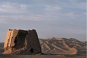
Dunhuang was one the frontier garrison
Garrison
Garrison is the collective term for a body of troops stationed in a particular location, originally to guard it, but now often simply using it as a home base....
towns established by the Emperor Wu after the defeat of Xiongnu, and the Chinese built fortifications at Dunhuang and sent settlers there. The name Dunhuang, or Blazing Beacon, refers to the beacons lit to warn of attacks by marauding nomadic tribes. Dunhuang Commandery was probably established in 104 BC, or shortly thereafter. Located in the western end of the Hexi Corridor
Hexi Corridor
Hexi Corridor or Gansu Corridor refers to the historical route in Gansu province of China. As part of the Northern Silk Road running northwest from the bank of the Yellow River, it was the most important route from North China to the Tarim Basin and Central Asia for traders and the military. The...
near the historic junction of the Northern
Northern Silk Road
The Northern Silk Road is a prehistoric trackway in northern China originating in the early capital of Xi'an and extending north of the Taklamakan Desert to reach the ancient kingdoms of Parthia, Bactria and eventually Persia and Rome. It is the northern-most branch of several Silk Roads providing...
and Southern Silk Road
Silk Road
The Silk Road or Silk Route refers to a historical network of interlinking trade routes across the Afro-Eurasian landmass that connected East, South, and Western Asia with the Mediterranean and European world, as well as parts of North and East Africa...
s, Dunhuang was a town of military importance.
"The Great Wall was extended to Dunhuang, and a line of fortified beacon towers stretched westwards into the desert. By the second century AD Dunhuang had a population of more than 76,000 and was a key supply base for caravans that passed through the city: those setting out for the arduous trek across the desert loaded up with water and food supplies, and others arriving from the west gratefully looked upon the mirage-like sight of Dunhuang's walls, which signified safety and comfort. Dunhuang prospered on the heavy flow of traffic. The first Buddhist caves in the Dunhuang area were hewn in 353."
In later centuries, during the Sui
Sui Dynasty
The Sui Dynasty was a powerful, but short-lived Imperial Chinese dynasty. Preceded by the Southern and Northern Dynasties, it ended nearly four centuries of division between rival regimes. It was followed by the Tang Dynasty....
and Tang
Tang Dynasty
The Tang Dynasty was an imperial dynasty of China preceded by the Sui Dynasty and followed by the Five Dynasties and Ten Kingdoms Period. It was founded by the Li family, who seized power during the decline and collapse of the Sui Empire...
dynasties, it was a major point of communication between ancient China and Central Asia
Central Asia
Central Asia is a core region of the Asian continent from the Caspian Sea in the west, China in the east, Afghanistan in the south, and Russia in the north...
. By the Tang Dynasty it became the major hub of commerce of the Silk Road. Early Buddhist monk
Monk
A monk is a person who practices religious asceticism, living either alone or with any number of monks, while always maintaining some degree of physical separation from those not sharing the same purpose...
s arrived at Dunhuang via the ancient Northern Silk Road, the northernmost route of about 2600 kilometres (1,615.6 mi) in length, which connected the ancient Chinese capital of Xi'an
Xi'an
Xi'an is the capital of the Shaanxi province, and a sub-provincial city in the People's Republic of China. One of the oldest cities in China, with more than 3,100 years of history, the city was known as Chang'an before the Ming Dynasty...
westward over the Wushao Ling Pass to Wuwei and on to Kashgar
Kashgar
Kashgar or Kashi is an oasis city with approximately 350,000 residents in the western part of the Xinjiang Uyghur Autonomous Region of the People's Republic of China. Kashgar is the administrative centre of Kashgar Prefecture which has an area of 162,000 km² and a population of approximately...
. For centuries, Buddhist monks at Dunhuang collected scriptures from the West
West
West is a noun, adjective, or adverb indicating direction or geography.West is one of the four cardinal directions or compass points. It is the opposite of east and is perpendicular to north and south.By convention, the left side of a map is west....
, and many pilgrims passed through the area, painting murals inside the Mogao Caves
Mogao Caves
The Mogao Caves or Mogao Grottoes , also known as the Caves of the Thousand Buddhas , form a system of 492 temples southeast of the center of Dunhuang, an oasis strategically located at a religious and cultural crossroads on the Silk Road, in Gansu province, China...
or "Caves of a Thousand Buddhas." A small number of Christian artifacts
Artifact (archaeology)
An artifact or artefact is "something made or given shape by man, such as a tool or a work of art, esp an object of archaeological interest"...
have also been found in the caves (see Jesus Sutras
Jesus Sutras
The Jesus Sutras are early Chinese language manuscripts of Christian teachings. They are connected with the 7th century mission of Alopen, a Nestorian bishop from Persia....
), testimony to the wide variety of people who made their way along the Silk Road.
As a frontier town, Dunhuang was fought over and occupied at various times by non-Han Chinese nationalities. The Tibetans
Tibetan Empire
The historic name for the Tibetan Empire is different from Tibet's present name.Traditional Tibetan history preserves a lengthy list of rulers, whose exploits become subject to external verification in the Chinese histories by the seventh century. From the 7th to the 11th century a series of...
occupied Dunhuang when the Tang empire became weakened considerably after the An Lushan Rebellion; even though it was later returned to Tang rule, it was under quasi-autonomous rule by the local general Zhang Yichao
Zhang Yichao
Zhang Yichao was an ethnic Han Chinese resident of Sha Prefecture , who, with the ruling Tufan state plunged into civil war, led a rebellion against the Tufan and reverted the region to allegiance to China's Tang Dynasty...
who expelled the Tibetans in 848. After the fall of Tang, Dunhaung was ruled by a local Cao family who formed alliances with the Uighurs and the Kingdom of Khotan
Kingdom of Khotan
The Kingdom of Khotan was an ancient Buddhist kingdom that was located on the branch of the Silk Road that ran along the southern edge of the Taklamakan Desert in the Tarim basin. -Early names:-Capital:...
. During the Song Dynasty
Song Dynasty
The Song Dynasty was a ruling dynasty in China between 960 and 1279; it succeeded the Five Dynasties and Ten Kingdoms Period, and was followed by the Yuan Dynasty. It was the first government in world history to issue banknotes or paper money, and the first Chinese government to establish a...
, Dunhuang fell outside the Chinese borders. In 1037 it came under the rule of Shazhou Uighurs, then in 1068 the Tanguts who founded the Xi Xia
Western Xia
The Western Xia Dynasty or the Tangut Empire, was known to the Tanguts and the Tibetans as Minyak.The state existed from 1038 to 1227 AD in what are now the northwestern Chinese provinces of Ningxia, Gansu, eastern Qinghai, northern Shaanxi, northeastern Xinjiang, southwest Inner Mongolia, and...
Dyansty. It was conquered in 1227 by the Mongols
Mongols
Mongols ) are a Central-East Asian ethnic group that lives mainly in the countries of Mongolia, China, and Russia. In China, ethnic Mongols can be found mainly in the central north region of China such as Inner Mongolia...
who sacked and destroyed the town, and became part of China again when Kublai Khan
Kublai Khan
Kublai Khan , born Kublai and also known by the temple name Shizu , was the fifth Great Khan of the Mongol Empire from 1260 to 1294 and the founder of the Yuan Dynasty in China...
conquered the rest of China. Dunhuang went into a steep decline after the Chinese trade with the outside world became dominated by Southern sea-routes, and the Silk Road was officially abandoned during the Ming Dynasty.
Today, the site is an important tourist attraction and the subject of an ongoing archaeological project. A large number of manuscript
Manuscript
A manuscript or handwrite is written information that has been manually created by someone or some people, such as a hand-written letter, as opposed to being printed or reproduced some other way...
s and artifacts retrieved at Dunhuang have been digitized and made publicly available via the International Dunhuang Project
International Dunhuang Project
The International Dunhuang Project is an international collaborative effort to conserve, catalogue and digitise manuscripts, printed texts, paintings, textiles and artefacts from Dunhuang and various other archaeological sites at the eastern end of the Silk Road...
. The expansion of the Kumtag Desert
Kumtag Desert
The Kumtag Desert, Kumtagh Desert or Desert of Kum-tag , literally "sand mountain desert" in Old Turkic language , is an arid landform in Northwestern China, which was proclaimed as a national park in the year 2002.-Definitions:1...
, which is resulting from long-standing overgrazing
Overgrazing
Overgrazing occurs when plants are exposed to intensive grazing for extended periods of time, or without sufficient recovery periods. It can be caused by either livestock in poorly managed agricultural applications, or by overpopulations of native or non-native wild animals.Overgrazing reduces the...
of surrounding lands, has reached the edges of the city. The city is also the namesake of prominent Chinese e-commerce site DHgate.com
DHgate.com
DHgate.com is a business-to-business e-Commerce website connecting Chinese suppliers with buyers overseas where users can order products directly through the site...
(simplified Chinese: 敦煌网; pinyin: Dūnhuángwǎng).
In 2011, satellite images showing huge structures in the desert near Dunhuang surfaced online and caused a brief media stir.
Climate
Dunhuang, being surrounded by high mountains, has an arid, continental climate. The annual average temperature is 9.48 °C (49.1 °F), but the monthly daily mean temperature ranges from 24.6 °C (76.3 °F) in July down to -8.3 °C in January. The city is extremely hot in summer and cold in winter, and usually has sharp temperature differences between day and night. Precipitation occurs only in trace amounts and quickly evaporates.Dunhaung Caves
A number of Buddhist cave sites are located in the Dunhuang area, the most important of these is the Mogao Caves which is located 25 km southwest of Dunhuang. There are 735 caves in Mogao. Numerous smaller Buddhist cave sites are located in the region, including the Western Thousand Buddha Caves, the Eastern Thousands Buddha Caves, Yulin Caves and the Five Temple site.Tourism
Apart from the Buddhist caves, a number of sites are of interest:- The Crescent Lake
- The Yumen Pass
- The YangguanYangguanYangguan, or Yangguan Pass , is a mountain pass that was fortified by Emperor Wu during the Western Han Dynasty and used as an outpost in ancient China. It is located approximately 43 to southwest of Dunhuang, in the Gansu province of Northwest China, which was in ancient times China's westernmost...
Pass - Mingsha Mountain
- White Horse Pagoda
- Dunhuang County MuseumDunhuang County MuseumDunhuang County Museum is a museum in Dunhuang, Gansu, northern China. It contains a number of Chinese and Tibetan items such as manuscripts from Cave 17 of Mogao Caves, which were salvaged from western lootings and domestic items....
External links
- Crescent Lake
- Echoing-Sand Mountain
- The International Dunhuang Project - includes tens of thousands of digitised manuscripts and paintings from Dunhuang, along with historical photographs and archival material
- British Museum: A Christian figure, ink and colours on a fragment of silk from Dunhuang
- Dunhuang Collection at the British Museum
- Dunhuang Collection at the National Museum of India
- Images and travelling impressions - in Spanish