

Lop Nur
Encyclopedia
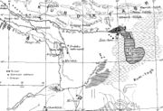
Lop Lake or Lop Nur is a group of small, now seasonal salt lake
sand marshes
between the Taklamakan and Kuruktag deserts in the Bayingolin Mongol Autonomous Prefecture, southeastern portion of Xinjiang Uygur Autonomous Region
in the People's Republic of China
.
The lake system into which the Tarim River
and Shule River
empty is the last remnant of the historical post-glacial Tarim Lake, which once covered more than 10000 km² (3,861 sq mi) in the Tarim Basin
. Lop Nur is hydrologically endorheic
—it is landbound and there is no outlet. Though it was determined to be a single salt lake by ancient Chinese geographers, the lake system has largely dried up from its 1928 measured area of 3100 km² (1,196.9 sq mi) and the desert has spread by windblown sandy loess
. This has shifted the lake system 30 to 40 km (18.6 to 24.9 ) westwards during the past 40 years. A partial cause for the destabilization of the desert has been the cutting of poplars and willows for firewood; in response, a reserve was established in 2003 to preserve 3520 km² (1,359.1 sq mi) of poplar
.
 From around 1800 BCE until the 9th century the lake supported a thriving Tocharian
culture. Archaeologists
have discovered the buried remains of settlements, as well as several of the Tarim mummies
, along its ancient shoreline. Former water resources of the Tarim River and Lop Nur nurtured the kingdom of Loulan since the second century BCE, an ancient civilization along the Silk Road
, which skirted the lake-filled basin. Loulan became a client-state of the Chinese empire in 55 BCE, renamed Shanshan
. Marco Polo
passed near the lake, and the famous explorers Ferdinand von Richthofen
, Nikolai Przhevalsky
, Sven Hedin
and Aurel Stein visited and studied the area. It is also likely that Swedish soldier Johan Gustaf Renate had visited the area when he was helping the Zunghars to produce maps over the area in the eighteenth century.
On June 17, 1980, Chinese archeologist Peng Jiamu
disappeared while walking into Lop Nur in search of water. His body was never found, and his disappearance continues to be one of the most mysterious events in the history of Chinese archeology. On June 13, 1996, the Chinese explorer Yu Chunshun
died while trying to walk across Lop Nur.
", was tested at Lop Nur in 1964. The PRC detonated its first hydrogen bomb on June 17, 1967. Since 1964, the lake has been used as a nuclear test site. Until 1996, 45 nuclear tests
were conducted. The headquarters of the test base is at Malan, about 125 km (77.7 mi) northwest of Qinggir
.
In 2010, construction started on a 370 km (229.9 mi) railway along the same route, which will facilitate taking the potassium-rich salt mined at the lake to the Lanxin Railway
mainline.
, Kongque River, Qiemo River
and Kaidu River
.
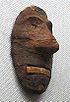 This bronze-age burial site is an oblong sand dune, from which more than thirty well preserved mummies, found in airtight ox-hide bags, have been excavated. The entire Xiaohe Tomb complex
contains about 330 tombs, about 160 of which have been violated by grave robbers.
A local hunter guided the Swedish explorer and archeologist Folke Bergman
to the site in 1934. An excavation project by the Xinjiang Cultural Relics and Archaeology Institute began in October, 2003. A total of 167 tombs have been dug up since the end of 2002 and excavations have revealed hundreds of smaller tombs built in layers, as well as other precious artifacts. In 2006, a valuable archeological finding was uncovered: a boat-shaped coffin wrapped in ox hide, containing the mummified face of a young woman, smiling.
Salt lake
A salt lake or saline lake is a landlocked body of water which has a concentration of salts and other dissolved minerals significantly higher than most lakes . In some cases, salt lakes have a higher concentration of salt than sea water, but such lakes would also be termed hypersaline lakes...
sand marshes
Salt marsh
A salt marsh is an environment in the upper coastal intertidal zone between land and salt water or brackish water, it is dominated by dense stands of halophytic plants such as herbs, grasses, or low shrubs. These plants are terrestrial in origin and are essential to the stability of the salt marsh...
between the Taklamakan and Kuruktag deserts in the Bayingolin Mongol Autonomous Prefecture, southeastern portion of Xinjiang Uygur Autonomous Region
Xinjiang
Xinjiang is an autonomous region of the People's Republic of China. It is the largest Chinese administrative division and spans over 1.6 million km2...
in the People's Republic of China
People's Republic of China
China , officially the People's Republic of China , is the most populous country in the world, with over 1.3 billion citizens. Located in East Asia, the country covers approximately 9.6 million square kilometres...
.
The lake system into which the Tarim River
Tarim River
The Tarim River is the principal river of the Xinjiang Uygur Autonomous Region in the People's Republic of China...
and Shule River
Shule River
The Shule River flows generally westwards through the Tibetan Plateau and the desert regions of northwestern China. It starts in the Qilian Mountains and stretches for some ; however, the river dries up about two-thirds of the way along its course and is lost in the Kumtag Desert, an endorheic...
empty is the last remnant of the historical post-glacial Tarim Lake, which once covered more than 10000 km² (3,861 sq mi) in the Tarim Basin
Tarim Basin
The Tarim Basin is a large endorheic basin occupying an area of about . It is located in the Xinjiang Uyghur Autonomous Region in China's far west. Its northern boundary is the Tian Shan mountain range and its southern is the Kunlun Mountains on the northern edge of the Tibetan Plateau. The...
. Lop Nur is hydrologically endorheic
Endorheic
An endorheic basin is a closed drainage basin that retains water and allows no outflow to other bodies of water such as rivers or oceans...
—it is landbound and there is no outlet. Though it was determined to be a single salt lake by ancient Chinese geographers, the lake system has largely dried up from its 1928 measured area of 3100 km² (1,196.9 sq mi) and the desert has spread by windblown sandy loess
Loess
Loess is an aeolian sediment formed by the accumulation of wind-blown silt, typically in the 20–50 micrometre size range, twenty percent or less clay and the balance equal parts sand and silt that are loosely cemented by calcium carbonate...
. This has shifted the lake system 30 to 40 km (18.6 to 24.9 ) westwards during the past 40 years. A partial cause for the destabilization of the desert has been the cutting of poplars and willows for firewood; in response, a reserve was established in 2003 to preserve 3520 km² (1,359.1 sq mi) of poplar
Poplar
Populus is a genus of 25–35 species of deciduous flowering plants in the family Salicaceae, native to most of the Northern Hemisphere. English names variously applied to different species include poplar , aspen, and cottonwood....
.
History
Tocharians
The Tocharians were the Tocharian-speaking inhabitants of the Tarim Basin, making them the easternmost speakers of Indo-European languages in antiquity. They were known as, or at least closely related to, the Yuezhi of Chinese sources...
culture. Archaeologists
Archaeology
Archaeology, or archeology , is the study of human society, primarily through the recovery and analysis of the material culture and environmental data that they have left behind, which includes artifacts, architecture, biofacts and cultural landscapes...
have discovered the buried remains of settlements, as well as several of the Tarim mummies
Tarim mummies
The Tarim mummies are a series of mummies discovered in the Tarim Basin in present-day Xinjiang, China, which date from 1900 BC to 200 AD. Some of the mummies are frequently associated with the presence of the Indo-European Tocharian languages in the Tarim Basin, although the evidence is not...
, along its ancient shoreline. Former water resources of the Tarim River and Lop Nur nurtured the kingdom of Loulan since the second century BCE, an ancient civilization along the Silk Road
Silk Road
The Silk Road or Silk Route refers to a historical network of interlinking trade routes across the Afro-Eurasian landmass that connected East, South, and Western Asia with the Mediterranean and European world, as well as parts of North and East Africa...
, which skirted the lake-filled basin. Loulan became a client-state of the Chinese empire in 55 BCE, renamed Shanshan
Shanshan
Shanshan is the Chinese name for a kingdom that existed roughly from 200 BCE-1000 CE at the north-eastern end of the Taklamakan Desert including the great, but now mostly dry, salt lake known as Lop Nur....
. Marco Polo
Marco Polo
Marco Polo was a Venetian merchant traveler from the Venetian Republic whose travels are recorded in Il Milione, a book which did much to introduce Europeans to Central Asia and China. He learned about trading whilst his father and uncle, Niccolò and Maffeo, travelled through Asia and apparently...
passed near the lake, and the famous explorers Ferdinand von Richthofen
Ferdinand von Richthofen
Ferdinand Freiherr von Richthofen was a German traveller, geographer, and scientist.-Biography:He was born in Carlsruhe, Prussian Silesia, and was educated in Breslau and Berlin. He traveled or studied in the Alps of Tyrol and the Carpathians in Transylvania...
, Nikolai Przhevalsky
Nikolai Przhevalsky
Nikolai Mikhaylovich Przhevalsky and Prjevalsky, ; —), was a Russian geographer of Polish background and explorer of Central and Eastern Asia. Although he never reached his final goal, Lhasa in Tibet, he travelled through regions unknown to the west, such as northern Tibet, modern Qinghai and...
, Sven Hedin
Sven Hedin
Sven Anders Hedin KNO1kl RVO was a Swedish geographer, topographer, explorer, photographer, and travel writer, as well as an illustrator of his own works...
and Aurel Stein visited and studied the area. It is also likely that Swedish soldier Johan Gustaf Renate had visited the area when he was helping the Zunghars to produce maps over the area in the eighteenth century.
On June 17, 1980, Chinese archeologist Peng Jiamu
Peng Jiamu
Peng Jiamu was a Chinese biochemist and explorer, who was lost in the Lop Nur desert. His disappearance sparked a huge highly publicised and fruitless search. In late 1990s, a TV-series named "Searching for Peng Jiamu" was broadcast across the People's Republic of China. In 2005 his skeleton may...
disappeared while walking into Lop Nur in search of water. His body was never found, and his disappearance continues to be one of the most mysterious events in the history of Chinese archeology. On June 13, 1996, the Chinese explorer Yu Chunshun
Yu Chunshun
Yu Chunshun was a Chinese explorer. He died of dehydration in 1996 while searching for a lost oasis in the Lop Nur desert in Xinjiang province, People's Republic of China. His body was discovered only two kilometers away from his next buried cache of food and water.-External links:*...
died while trying to walk across Lop Nur.
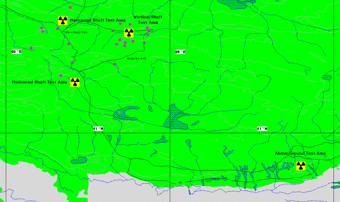
Lop Nur Nuclear Weapons Test Base
The first Chinese nuclear bomb test, codenamed "596596 (nuclear test)
596 is the codename of the People's Republic of China's first nuclear weapons test, detonated on October 16, 1964 at the Lop Nur test site. It was a uranium-235 implosion fission device and had a yield of 22 kilotons...
", was tested at Lop Nur in 1964. The PRC detonated its first hydrogen bomb on June 17, 1967. Since 1964, the lake has been used as a nuclear test site. Until 1996, 45 nuclear tests
Nuclear testing
Nuclear weapons tests are experiments carried out to determine the effectiveness, yield and explosive capability of nuclear weapons. Throughout the twentieth century, most nations that have developed nuclear weapons have tested them...
were conducted. The headquarters of the test base is at Malan, about 125 km (77.7 mi) northwest of Qinggir
Qinggir
Qinggir is a population center located in the Xinjiang Uyghur Autonomous Region of China.The Qinggir region in Lop Nur is used for vertical shaft nuclear weapons testing.-External links:*...
.
Transportation
In 2006, a highway from Hami to Lop Nur (Xinjiang Provincial Hwy 235) was completed.In 2010, construction started on a 370 km (229.9 mi) railway along the same route, which will facilitate taking the potassium-rich salt mined at the lake to the Lanxin Railway
Lanxin railway
The Lanzhou−Xinjiang Railway or Lanxin Railway is the longest railway in northwestern China. It runs from Lanzhou, Gansu, through the Hexi Corridor, to Ürümqi, in the Xinjiang. It is Xinjiang's only rail link with the rest of China...
mainline.
Water System
The rivers that feed the Lop Nur marshes include the Tarim RiverTarim River
The Tarim River is the principal river of the Xinjiang Uygur Autonomous Region in the People's Republic of China...
, Kongque River, Qiemo River
Qiemo River
The Qiemo River , also called the Cherchen or Qarqan River, runs across the Tarim Basin in the Xinjiang Uyghur Autonomous Region. It feeds into the Lop Nor salty marshes.- See also :* Qiemo County* Qiemo Town...
and Kaidu River
Kaidu River
The Kaidu River , also known under its ancient name Liusha River or Chaidu-gol is a river in the Xinjiang Uyghur Autonomous Region of China and an important source of water for the region....
.
Xiaohe Burial Site
Xiaohe Tomb complex
The Xiaohe 'Little River' Tomb complex refers to a bronze-age burial site located in Lop Nur, in the Xinjiang Uygur Autonomous Region of western China. It is an oblong sand dune, from which more than 30 well-preserved mummies, buried in air-tight ox-hide bags, have been excavated...
contains about 330 tombs, about 160 of which have been violated by grave robbers.
A local hunter guided the Swedish explorer and archeologist Folke Bergman
Folke Bergman
Folke Bergman was a Swedish explorer and archaeologist. He is best known for his discovery of the Xiaohe Tomb complex in Lop Nur, China in 1934.-Primary:...
to the site in 1934. An excavation project by the Xinjiang Cultural Relics and Archaeology Institute began in October, 2003. A total of 167 tombs have been dug up since the end of 2002 and excavations have revealed hundreds of smaller tombs built in layers, as well as other precious artifacts. In 2006, a valuable archeological finding was uncovered: a boat-shaped coffin wrapped in ox hide, containing the mummified face of a young woman, smiling.
See also
- Lop DesertLop DesertThe Lop Desert or Lop Nur or Lop Nor, is a desert extending from Korla eastwards along the foot of the Kuruktagh to the formerly terminal Tarim Basin in the Xinjiang Uygur Autonomous Region of China. It is an almost perfectly horizontal expanse...
- Tarim BasinTarim BasinThe Tarim Basin is a large endorheic basin occupying an area of about . It is located in the Xinjiang Uyghur Autonomous Region in China's far west. Its northern boundary is the Tian Shan mountain range and its southern is the Kunlun Mountains on the northern edge of the Tibetan Plateau. The...
- Tarim mummiesTarim mummiesThe Tarim mummies are a series of mummies discovered in the Tarim Basin in present-day Xinjiang, China, which date from 1900 BC to 200 AD. Some of the mummies are frequently associated with the presence of the Indo-European Tocharian languages in the Tarim Basin, although the evidence is not...
- Silk Road transmission of BuddhismSilk Road transmission of BuddhismThe Silk Road transmission of Buddhism to China is most commonly thought to have started in the late 2nd or the 1st century CE.The first documented translation efforts by Buddhist monks in China were in the 2nd century CE, possibly as a consequence of the expansion of the Kushan Empire into the...
External links
- Map of the Lop Nur nuclear test facility
- Lop Nor Nuclear Weapons Test Base
- Lop Desert
- Surveying the Lop Nor
- Salt Fields in Former “Wandering” Lake Lop Nur, China - May 13th, 2009 - Earth Snapshot
- Downloadable article: "Evidence that a West-East admixed population lived in the Tarim Basin as early as the early Bronze Age" Li et al. BMC Biology 2010, 8:15. http://www.biomedcentral.com/content/pdf/1741-7007-8-15.pdf