

Tibet Autonomous Region
Encyclopedia
The Tibet Autonomous Region (TAR), Tibet or Xizang for short, also called the Xizang Autonomous Region is a province
-level autonomous region of the People's Republic of China
(PRC), created in 1965.
Within the People's Republic of China
, Tibet is identified with the Autonomous Region, which includes about half of ethno-cultural Tibet
, including the traditional provinces of Ü-Tsang
and the western half of Kham
. The borders of the present Autonomous Region coincide roughly with the actual zone of control of the then-government of Tibet in 1950. The Tibet Autonomous Region is the second-largest province-level division of China by area, spanning over 1200000 square kilometres (463,322.6 sq mi), after Xinjiang
, and due to its generally harsh terrain, is the least densely populated provincial-level division of the PRC.
and western Kham
) was ruled by the government of Tibet headed by the Dalai Lama
. Other parts of ethno-cultural Tibet (eastern Kham
and Amdo
) had not been under the administration of the Tibetan government since the mid-eighteenth century; today they are distributed among the provinces of Qinghai
, Gansu
, Sichuan
and Yunnan
. (See also: Xikang
province)
In 1950, the People's Liberation Army defeated the Tibetan army in a battle fought near the city of Qamdo
. In 1951, the Tibetan representatives signed a seventeen-point agreement
with the Chinese Central People's Government
affirming China's sovereignty
over Tibet. The agreement was ratified in Lhasa a few months later. Although the 17-point agreement had provided for an autonomous administration led by the Dalai Lama, a "Preparatory Committee for the Autonomous Region of Tibet" (PCART) was established in 1955 to create a parallel system of administration along Communist lines. The Dalai Lama fled to India in 1959 and renounced the 17-point agreement. PCART was reorganized as the Tibet Autonomous Region in 1965, thus making Tibet an administrative division on the same legal footing as a Chinese province.
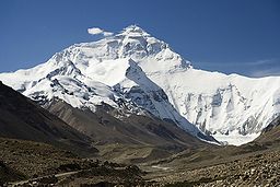
, the highest region on earth. In northern Tibet elevations reach an average of over 4572 metres (15,000 ft). Mount Everest
is located on Tibet's border with Nepal
.
The Chinese provincial-level areas of Xinjiang
, Qinghai
and Sichuan
lie to the north, northeast, and east, respectively, of the Tibet AR. There is also a short border with Yunnan
province to the southeast. The PRC has border disputes with the Republic of India over the McMahon Line
of Arunachal Pradesh
, known to the Chinese as "South Tibet
". The disputed territory of Aksai Chin
is to the west, and its boundary with that region is not defined. The other countries to the south are Myanmar
, Bhutan
and Nepal
.
 Physically, the Tibet AR may be divided into two parts, the "lakes region" in the west and north-west, and the "river region", which spreads out on three sides of the former on the east, south, and west. Both regions receive limited amounts of rainfall as they lie in the rain shadow
of the Himalayas, however the region names are useful in contrasting their hydrological
structures, and also in contrasting their different cultural uses which is nomad
ic in the lake region and agricultural
in the river region. On the south the Tibet AR is bounded by the Himalayas
, and on the north by a broad mountain system. The system at no point narrows to a single range; generally there are three or four across its breadth. As a whole the system forms the watershed between rivers flowing to the Indian Ocean
– the Indus
, Brahmaputra
and Salween
and its tributaries – and the streams flowing into the undrained salt lakes to the north.
The lake region extends from the Pangong Tso Lake
in Ladakh
, Lake Rakshastal
, Yamdrok Lake
and Lake Manasarovar
near the source of the Indus River
, to the sources of the Salween, the Mekong
and the Yangtze
. Other lakes include Dagze Co
, Nam Co, and Pagsum Co. The lake region is an arid and wind-swept desert. This region is called the Chang Tang (Byang sang) or 'Northern Plateau' by the people of Tibet. It is some 1100 km (700 mi) broad, and covers an area about equal to that of France
. Due to its great distance from the ocean it is extremely arid and possesses no river outlet. The mountain ranges are spread out, rounded, disconnected, separated by flat valleys relatively of little depth.
The Tibet AR is dotted over with large and small lakes, generally salt or alkaline, and intersected by streams. Due to the presence of discontinuous permafrost over the Chang Tang, the soil is boggy and covered with tussocks of grass, thus resembling the Siberian tundra
. Salt and fresh-water lakes are intermingled. The lakes are generally without outlet, or have only a small effluent
. The deposits consist of soda
, potash
, borax
and common salt
. The lake region is noted for a vast number of hot spring
s, which are widely distributed between the Himalaya and 34° N., but are most numerous to the west of Tengri Nor (north-west of Lhasa). So intense is the cold in this part of Tibet that these springs are sometimes represented by columns of ice, the nearly boiling water having frozen in the act of ejection.
The river region is characterised by fertile mountain valleys and includes the Yarlung Tsangpo River (the upper courses of the Brahmaputra) and its major tributary, the Nyang River
, the Salween, the Yangtze
, the Mekong
, and the Yellow River
. The Yarlung Tsangpo Canyon
, formed by a horseshoe bend in the river where it flows around Namcha Barwa
, is the deepest, and possibly longest canyon in the world. Among the mountains there are many narrow valleys. The valleys of Lhasa
, Shigatse
, Gyantse
and the Brahmaputra are free from permafrost, covered with good soil and groves of trees, well irrigated, and richly cultivated.
The South Tibet Valley is formed by the Yarlung Zangbo River during its middle reaches, where it travels from west to east. The valley is approximately 1200 kilometres long and 300 kilometres wide. The valley descends from 4500 metres above sea level to 2800 metres. The mountains on either side of the valley are usually around 5000 metres high. Lakes here include Lake Paiku
and Lake Puma Yumco
.
. It is governed by a People's Government, led by a Chairman. In practice, however, the Chairman is subordinate to the branch secretary of the Communist Party of China
. As a matter of convention, the Chairman has almost always been an ethnic Tibetan, while the party secretary has almost always been a non-Tibetan. The current Chairman is Padma Choling
and the current party secretary is Zhang Qingli
.
and six prefectures.
These in turn are subdivided into a total of seventy-one counties, one district (Chengguan District, Lhasa
) and one county-level city
(Xigazê).
among any of the Chinese province-level administrative regions, mostly due to its harsh and rugged terrain.
In 2009 the Tibetan population was 2.91 million. The ethnic Tibetans
, comprising 92.8% of the population, mainly adhere to Tibetan Buddhism
and Bön, although there is an ethnic Tibetan Muslim community
. Other Muslim ethnic groups such as the Hui
and the Salar have long inhabited the Region. Smaller tribal groups such as the Monpa and Lhoba
, who follow a combination of Tibetan Buddhism
and spirit worship, are found mainly in the southeastern parts of the region.
Historically, the population of Tibet consisted of primarily ethnic Tibetans
. According to tradition the original ancestors of the Tibetan people, as represented by the six red bands in the Tibetan flag, are: the Se, Mu, Dong, Tong, Dru and Ra. Other traditional ethnic groups with significant population or with the majority of the ethnic group reside in Tibet include Bai people, Blang
, Bonan
, Dongxiang
, Han
, Hui people
, Lhoba
, Lisu people, Miao
, Mongols
, Monguor (Tu people), Menba (Monpa), Mosuo
, Nakhi
, Qiang, Nu people
, Pumi, Salar, and Yi people
.
Most Han people
in the TAR (6.1% of the total population) are recent migrants, because all of the Han were expelled
from Outer Tibet following the British expedition
until the establishment of the PRC. Some ethnic Tibetans claim that, with the 2006 completion of the Qingzang Railway
connecting the TAR to Qinghai Province, there has been an "acceleration" of Han migration into the region. The Central Tibetan Administration of the Dalai Lama claims that the PRC has actively swamped Tibet with migrants in order to alter Tibet's demographic makeup.
 The Tibetans traditionally depended upon agriculture for survival. Since the 1980s, however, other jobs such as taxi-driving and hotel retail work have become available in the wake of Chinese economic reform
. In 2009, Tibet's nominal GDP
topped 44.1 billion yuan (US$6.5 billion), nearly more than four times as big as the 11.78 billion yuan (US$1.47 billion) in 2000. In the past five years, Tibet's annual GDP growth has averaged 12%.
While traditional agricultural work and animal husbandry continue to lead the area's economy, in 2005 the tertiary sector contributed more than half of its GDP growth, the first time it surpassed the area's primary industry. Rich reserves of natural resources and raw materials have yet to lead to the creation of a strong secondary sector, due in large part to the province's inhospitable terrain, low population density, an underdeveloped infrastructure and the high cost of extraction.
The collection of caterpillar fungus (Cordyceps sinensis, known in Tibetan as Yartsa Gunbu) in late spring / early summer is in many areas the most important source of cash for rural households. It contributes an average of 40% to rural cash income and 8.5% to the TAR's GDP. The re-opening of the Nathu La
pass (on southern Tibet's border with India) should facilitate Sino-Indian border trade and boost Tibet's economy.
In 2008, Chinese news media reported that the per capita
disposable income
s of urban and rural residents in Tibet averaged 12,482 yuan (US$1,798) and 3,176 yuan (US$457) respectively.
The China Western Development
policy was adopted in 2000 by the central government to boost economic development in western China, including the Tibet Autonomous Region.
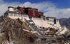 Tourists were first permitted to visit the Tibet Autonomous Region in the 1980s. While the main attraction is the Potala Palace
in Lhasa
, there are many other popular tourist destinations including the Jokhang Temple
, Namtso Lake
, and Tashilhunpo Monastery
.
, Qamdo Bangda Airport
, Nyingchi Airport
, and the Gunsa Airport
.
Gunsa Airport in Ngari Prefecture
began operations on July 1, 2010, to become the fourth civil airport in China's Tibet Autonomous Region.
The "Peace Airport" for Xigazê Prefecture
was completed on October 30, 2010.
Nagqu Dagring Airport
is expected to become the world's highest altitude airport by 2014 at 4,436 meters above sea level.
Province (China)
A province, in the context of Chinese government, is a translation of sheng formally provincial level divisions, which is an administrative division. Provinces, municipalities, autonomous regions, and the special administrative regions, make up the four types of province of administrative division...
-level autonomous region of the People's Republic of China
People's Republic of China
China , officially the People's Republic of China , is the most populous country in the world, with over 1.3 billion citizens. Located in East Asia, the country covers approximately 9.6 million square kilometres...
(PRC), created in 1965.
Within the People's Republic of China
People's Republic of China
China , officially the People's Republic of China , is the most populous country in the world, with over 1.3 billion citizens. Located in East Asia, the country covers approximately 9.6 million square kilometres...
, Tibet is identified with the Autonomous Region, which includes about half of ethno-cultural Tibet
Tibet
Tibet is a plateau region in Asia, north-east of the Himalayas. It is the traditional homeland of the Tibetan people as well as some other ethnic groups such as Monpas, Qiang, and Lhobas, and is now also inhabited by considerable numbers of Han and Hui people...
, including the traditional provinces of Ü-Tsang
Ü-Tsang
Ü-Tsang , or Tsang-Ü, is one of the three traditional provinces of Tibet, the other two being Amdo and Kham. Geographically Ü-Tsang covered the central and western portions of the Tibetan cultural area, including the Tsang-po watershed, the western districts surrounding and extending past Mount...
and the western half of Kham
Kham
Kham , is a historical region covering a land area largely divided between present-day Tibetan Autonomous Region and Sichuan province, with smaller portions located within Qinghai, Gansu and Yunnan provinces of China. During the Republic of China's rule over mainland China , most of the region was...
. The borders of the present Autonomous Region coincide roughly with the actual zone of control of the then-government of Tibet in 1950. The Tibet Autonomous Region is the second-largest province-level division of China by area, spanning over 1200000 square kilometres (463,322.6 sq mi), after Xinjiang
Xinjiang
Xinjiang is an autonomous region of the People's Republic of China. It is the largest Chinese administrative division and spans over 1.6 million km2...
, and due to its generally harsh terrain, is the least densely populated provincial-level division of the PRC.
History
From 1912 to 1950, the present extent of the Tibet Autonomous Region (comprising Ü-TsangÜ-Tsang
Ü-Tsang , or Tsang-Ü, is one of the three traditional provinces of Tibet, the other two being Amdo and Kham. Geographically Ü-Tsang covered the central and western portions of the Tibetan cultural area, including the Tsang-po watershed, the western districts surrounding and extending past Mount...
and western Kham
Kham
Kham , is a historical region covering a land area largely divided between present-day Tibetan Autonomous Region and Sichuan province, with smaller portions located within Qinghai, Gansu and Yunnan provinces of China. During the Republic of China's rule over mainland China , most of the region was...
) was ruled by the government of Tibet headed by the Dalai Lama
Dalai Lama
The Dalai Lama is a high lama in the Gelug or "Yellow Hat" branch of Tibetan Buddhism. The name is a combination of the Mongolian word далай meaning "Ocean" and the Tibetan word bla-ma meaning "teacher"...
. Other parts of ethno-cultural Tibet (eastern Kham
Kham
Kham , is a historical region covering a land area largely divided between present-day Tibetan Autonomous Region and Sichuan province, with smaller portions located within Qinghai, Gansu and Yunnan provinces of China. During the Republic of China's rule over mainland China , most of the region was...
and Amdo
Amdo
Amdo is one of the three traditional regions of Tibet, the other two being Ü-Tsang and Kham; it is also the birth place of the 14th Dalai Lama. Amdo encompasses a large area from the Machu River to the Drichu river . While culturally and ethnically a Tibetan area, Amdo has been administered by a...
) had not been under the administration of the Tibetan government since the mid-eighteenth century; today they are distributed among the provinces of Qinghai
Qinghai
Qinghai ; Oirat Mongolian: ; ; Salar:) is a province of the People's Republic of China, named after Qinghai Lake...
, Gansu
Gansu
' is a province located in the northwest of the People's Republic of China.It lies between the Tibetan and Huangtu plateaus, and borders Mongolia, Inner Mongolia, and Ningxia to the north, Xinjiang and Qinghai to the west, Sichuan to the south, and Shaanxi to the east...
, Sichuan
Sichuan
' , known formerly in the West by its postal map spellings of Szechwan or Szechuan is a province in Southwest China with its capital in Chengdu...
and Yunnan
Yunnan
Yunnan is a province of the People's Republic of China, located in the far southwest of the country spanning approximately and with a population of 45.7 million . The capital of the province is Kunming. The province borders Burma, Laos, and Vietnam.Yunnan is situated in a mountainous area, with...
. (See also: Xikang
Xikang
Xikang or Sikang , is a defunct province of the Republic of China , comprising most of the Kham region of traditional Tibet, where Khampas, a subgroup of the Tibetan ethnicity, live. The area is also home to a small minority of Mongol ethnicity...
province)
In 1950, the People's Liberation Army defeated the Tibetan army in a battle fought near the city of Qamdo
Qamdo
Qamdo , Chamdo , 昌都 can refer to:* Chamdo, a town in Tibet* Qamdo Region, a former administrative region in western Kham, Tibet - see Qamdo Prefecture...
. In 1951, the Tibetan representatives signed a seventeen-point agreement
Seventeen Point Agreement for the Peaceful Liberation of Tibet
The Agreement of the Central People's Government and the Local Government of Tibet on Measures for the Peaceful Liberation of Tibet, or the Seventeen Point Agreement for the Peaceful Liberation of Tibet for short, is the document by which the delegates of the 14th Dalai Lama allegedly reached an...
with the Chinese Central People's Government
Central People's Government
The Central People's Government is the central government of the People's Republic of China in Beijing. According to the 1982 Constitution, "Central People's Government" is synonymous with the State Council.-History:...
affirming China's sovereignty
Sovereignty
Sovereignty is the quality of having supreme, independent authority over a geographic area, such as a territory. It can be found in a power to rule and make law that rests on a political fact for which no purely legal explanation can be provided...
over Tibet. The agreement was ratified in Lhasa a few months later. Although the 17-point agreement had provided for an autonomous administration led by the Dalai Lama, a "Preparatory Committee for the Autonomous Region of Tibet" (PCART) was established in 1955 to create a parallel system of administration along Communist lines. The Dalai Lama fled to India in 1959 and renounced the 17-point agreement. PCART was reorganized as the Tibet Autonomous Region in 1965, thus making Tibet an administrative division on the same legal footing as a Chinese province.
Geography
The Tibet Autonomous Region is located on the Tibetan PlateauTibetan Plateau
The Tibetan Plateau , also known as the Qinghai–Tibetan Plateau is a vast, elevated plateau in Central Asia covering most of the Tibet Autonomous Region and Qinghai, in addition to smaller portions of western Sichuan, southwestern Gansu, and northern Yunnan in Western China and Ladakh in...
, the highest region on earth. In northern Tibet elevations reach an average of over 4572 metres (15,000 ft). Mount Everest
Mount Everest
Mount Everest is the world's highest mountain, with a peak at above sea level. It is located in the Mahalangur section of the Himalayas. The international boundary runs across the precise summit point...
is located on Tibet's border with Nepal
Nepal
Nepal , officially the Federal Democratic Republic of Nepal, is a landlocked sovereign state located in South Asia. It is located in the Himalayas and bordered to the north by the People's Republic of China, and to the south, east, and west by the Republic of India...
.
The Chinese provincial-level areas of Xinjiang
Xinjiang
Xinjiang is an autonomous region of the People's Republic of China. It is the largest Chinese administrative division and spans over 1.6 million km2...
, Qinghai
Qinghai
Qinghai ; Oirat Mongolian: ; ; Salar:) is a province of the People's Republic of China, named after Qinghai Lake...
and Sichuan
Sichuan
' , known formerly in the West by its postal map spellings of Szechwan or Szechuan is a province in Southwest China with its capital in Chengdu...
lie to the north, northeast, and east, respectively, of the Tibet AR. There is also a short border with Yunnan
Yunnan
Yunnan is a province of the People's Republic of China, located in the far southwest of the country spanning approximately and with a population of 45.7 million . The capital of the province is Kunming. The province borders Burma, Laos, and Vietnam.Yunnan is situated in a mountainous area, with...
province to the southeast. The PRC has border disputes with the Republic of India over the McMahon Line
McMahon Line
The McMahon Line is a line agreed to by Great Britain and Tibet as part of Simla Accord, a treaty signed in 1914. Although its legal status is disputed by China, it is the effective boundary between China and India....
of Arunachal Pradesh
Arunachal Pradesh
Arunachal Pradesh is a state of India, located in the far northeast. It borders the states of Assam and Nagaland to the south, and shares international borders with Burma in the east, Bhutan in the west, and the People's Republic of China in the north. The majority of the territory is claimed by...
, known to the Chinese as "South Tibet
South Tibet
The Arunachal Pradesh dispute is a territorial dispute over the region located on the middle of the Yarlung Zangbo River, 300 km north of the Himalayas. It is entirely administered by India as part of its Arunachal Pradesh state; China claims it as a part of its Tibet Autonomous Region and...
". The disputed territory of Aksai Chin
Aksai Chin
Aksai Chin is one of the two main disputed border areas between China and India, and the other is South Tibet, which comprises most of India's Arunachal Pradesh. It is administered by China as part of Hotan County in the Hotan Prefecture of Xinjiang Autonomous Region, but is also claimed by India...
is to the west, and its boundary with that region is not defined. The other countries to the south are Myanmar
Myanmar
Burma , officially the Republic of the Union of Myanmar , is a country in Southeast Asia. Burma is bordered by China on the northeast, Laos on the east, Thailand on the southeast, Bangladesh on the west, India on the northwest, the Bay of Bengal to the southwest, and the Andaman Sea on the south....
, Bhutan
Bhutan
Bhutan , officially the Kingdom of Bhutan, is a landlocked state in South Asia, located at the eastern end of the Himalayas and bordered to the south, east and west by the Republic of India and to the north by the People's Republic of China...
and Nepal
Nepal
Nepal , officially the Federal Democratic Republic of Nepal, is a landlocked sovereign state located in South Asia. It is located in the Himalayas and bordered to the north by the People's Republic of China, and to the south, east, and west by the Republic of India...
.
Rain shadow
A rain shadow is a dry area on the lee side of a mountainous area. The mountains block the passage of rain-producing weather systems, casting a "shadow" of dryness behind them. As shown by the diagram to the right, the warm moist air is "pulled" by the prevailing winds over a mountain...
of the Himalayas, however the region names are useful in contrasting their hydrological
Hydrology
Hydrology is the study of the movement, distribution, and quality of water on Earth and other planets, including the hydrologic cycle, water resources and environmental watershed sustainability...
structures, and also in contrasting their different cultural uses which is nomad
Nomad
Nomadic people , commonly known as itinerants in modern-day contexts, are communities of people who move from one place to another, rather than settling permanently in one location. There are an estimated 30-40 million nomads in the world. Many cultures have traditionally been nomadic, but...
ic in the lake region and agricultural
Agriculture
Agriculture is the cultivation of animals, plants, fungi and other life forms for food, fiber, and other products used to sustain life. Agriculture was the key implement in the rise of sedentary human civilization, whereby farming of domesticated species created food surpluses that nurtured the...
in the river region. On the south the Tibet AR is bounded by the Himalayas
Himalayas
The Himalaya Range or Himalaya Mountains Sanskrit: Devanagari: हिमालय, literally "abode of snow"), usually called the Himalayas or Himalaya for short, is a mountain range in Asia, separating the Indian subcontinent from the Tibetan Plateau...
, and on the north by a broad mountain system. The system at no point narrows to a single range; generally there are three or four across its breadth. As a whole the system forms the watershed between rivers flowing to the Indian Ocean
Indian Ocean
The Indian Ocean is the third largest of the world's oceanic divisions, covering approximately 20% of the water on the Earth's surface. It is bounded on the north by the Indian Subcontinent and Arabian Peninsula ; on the west by eastern Africa; on the east by Indochina, the Sunda Islands, and...
– the Indus
Indus River
The Indus River is a major river which flows through Pakistan. It also has courses through China and India.Originating in the Tibetan plateau of western China in the vicinity of Lake Mansarovar in Tibet Autonomous Region, the river runs a course through the Ladakh district of Jammu and Kashmir and...
, Brahmaputra
Brahmaputra River
The Brahmaputra , also called Tsangpo-Brahmaputra, is a trans-boundary river and one of the major rivers of Asia. It is the only Indian river that is attributed the masculine gender and thus referred to as a in Indo-Aryan languages and languages with Indo-Aryan influence...
and Salween
Salween River
The Salween is a river, about long, that flows from the Tibetan Plateau into the Andaman Sea in Southeast Asia. It drains a narrow and mountainous watershed of that extends into the countries China, Burma and Thailand. Steep canyon walls line the swift, powerful and undammed Salween, one of the...
and its tributaries – and the streams flowing into the undrained salt lakes to the north.
The lake region extends from the Pangong Tso Lake
Pangong Tso
Pangong Tso is an endorheic lake in the Himalayas situated at a height of about . It is long and extends from India to Tibet. 60% of the length of the lake lies in China. The lake is wide at its broadest point...
in Ladakh
Ladakh
Ladakh is a region of Jammu and Kashmir, the northernmost state of the Republic of India. It lies between the Kunlun mountain range in the north and the main Great Himalayas to the south, inhabited by people of Indo-Aryan and Tibetan descent...
, Lake Rakshastal
Lake Rakshastal
Lake Rakshastal is a lake in Tibet, lying close to the west of Lake Manasarovar and Mount Kailash. The Satluj River originates at Rakshastal's northwestern tip. Despite its close proximity to Lake Manasarovar—over the road to Purang County, Lake Rakshastal does not share the lore of worship with...
, Yamdrok Lake
Yamdrok Lake
Yamdrok Lake is one of the three largest sacred lakes in Tibet . It is over long. The lake is surrounded by many snow-capped mountains and is fed by numerous small streams. The lake does have an outlet stream at its far western end....
and Lake Manasarovar
Lake Manasarovar
Lake Manasarovar, Mapam Yumco , or Manasa Sarovar/Lake Manas , is a fresh-water lake in Tibet Autonomous Region of China approximately from Lhasa. To the west of Lake Manasa Sarovar is Lake Rakshastal and towards the north is Mount Kailash...
near the source of the Indus River
Indus River
The Indus River is a major river which flows through Pakistan. It also has courses through China and India.Originating in the Tibetan plateau of western China in the vicinity of Lake Mansarovar in Tibet Autonomous Region, the river runs a course through the Ladakh district of Jammu and Kashmir and...
, to the sources of the Salween, the Mekong
Mekong
The Mekong is a river that runs through China, Burma, Laos, Thailand, Cambodia and Vietnam. It is the world's 10th-longest river and the 7th-longest in Asia. Its estimated length is , and it drains an area of , discharging of water annually....
and the Yangtze
Yangtze River
The Yangtze, Yangzi or Cháng Jiāng is the longest river in Asia, and the third-longest in the world. It flows for from the glaciers on the Tibetan Plateau in Qinghai eastward across southwest, central and eastern China before emptying into the East China Sea at Shanghai. It is also one of the...
. Other lakes include Dagze Co
Dagze Co
Dagzê Lake is one of many inland lakes in Tibet, with a present area of 260 km² . In glacial times, the region was considerably wetter, and lakes were correspondingly much larger. Changes in climate have resulted in greater aridity on the Tibetan Plateau...
, Nam Co, and Pagsum Co. The lake region is an arid and wind-swept desert. This region is called the Chang Tang (Byang sang) or 'Northern Plateau' by the people of Tibet. It is some 1100 km (700 mi) broad, and covers an area about equal to that of France
France
The French Republic , The French Republic , The French Republic , (commonly known as France , is a unitary semi-presidential republic in Western Europe with several overseas territories and islands located on other continents and in the Indian, Pacific, and Atlantic oceans. Metropolitan France...
. Due to its great distance from the ocean it is extremely arid and possesses no river outlet. The mountain ranges are spread out, rounded, disconnected, separated by flat valleys relatively of little depth.
The Tibet AR is dotted over with large and small lakes, generally salt or alkaline, and intersected by streams. Due to the presence of discontinuous permafrost over the Chang Tang, the soil is boggy and covered with tussocks of grass, thus resembling the Siberian tundra
Tundra
In physical geography, tundra is a biome where the tree growth is hindered by low temperatures and short growing seasons. The term tundra comes through Russian тундра from the Kildin Sami word tūndâr "uplands," "treeless mountain tract." There are three types of tundra: Arctic tundra, alpine...
. Salt and fresh-water lakes are intermingled. The lakes are generally without outlet, or have only a small effluent
Effluent
Effluent is an outflowing of water or gas from a natural body of water, or from a human-made structure.Effluent is defined by the United States Environmental Protection Agency as “wastewater - treated or untreated - that flows out of a treatment plant, sewer, or industrial outfall. Generally refers...
. The deposits consist of soda
Sodium carbonate
Sodium carbonate , Na2CO3 is a sodium salt of carbonic acid. It most commonly occurs as a crystalline heptahydrate, which readily effloresces to form a white powder, the monohydrate. Sodium carbonate is domestically well-known for its everyday use as a water softener. It can be extracted from the...
, potash
Potash
Potash is the common name for various mined and manufactured salts that contain potassium in water-soluble form. In some rare cases, potash can be formed with traces of organic materials such as plant remains, and this was the major historical source for it before the industrial era...
, borax
Borax
Borax, also known as sodium borate, sodium tetraborate, or disodium tetraborate, is an important boron compound, a mineral, and a salt of boric acid. It is usually a white powder consisting of soft colorless crystals that dissolve easily in water.Borax has a wide variety of uses...
and common salt
Salt
In chemistry, salts are ionic compounds that result from the neutralization reaction of an acid and a base. They are composed of cations and anions so that the product is electrically neutral...
. The lake region is noted for a vast number of hot spring
Hot spring
A hot spring is a spring that is produced by the emergence of geothermally heated groundwater from the Earth's crust. There are geothermal hot springs in many locations all over the crust of the earth.-Definitions:...
s, which are widely distributed between the Himalaya and 34° N., but are most numerous to the west of Tengri Nor (north-west of Lhasa). So intense is the cold in this part of Tibet that these springs are sometimes represented by columns of ice, the nearly boiling water having frozen in the act of ejection.
The river region is characterised by fertile mountain valleys and includes the Yarlung Tsangpo River (the upper courses of the Brahmaputra) and its major tributary, the Nyang River
Nyang River
The Nyang River is a major river in south-west Tibet and the longest tributary of the Yarlung Tsangpo river....
, the Salween, the Yangtze
Yangtze River
The Yangtze, Yangzi or Cháng Jiāng is the longest river in Asia, and the third-longest in the world. It flows for from the glaciers on the Tibetan Plateau in Qinghai eastward across southwest, central and eastern China before emptying into the East China Sea at Shanghai. It is also one of the...
, the Mekong
Mekong
The Mekong is a river that runs through China, Burma, Laos, Thailand, Cambodia and Vietnam. It is the world's 10th-longest river and the 7th-longest in Asia. Its estimated length is , and it drains an area of , discharging of water annually....
, and the Yellow River
Yellow River
The Yellow River or Huang He, formerly known as the Hwang Ho, is the second-longest river in China and the sixth-longest in the world at the estimated length of . Originating in the Bayan Har Mountains in Qinghai Province in western China, it flows through nine provinces of China and empties into...
. The Yarlung Tsangpo Canyon
Yarlung Tsangpo Canyon
The Yarlung Zangbo Grand Canyon or simply the Tsangpo Canyon or Tsangpo Gorge, along the Yarlung Tsangpo River in Tibet, China, is regarded by some as the deepest canyon in the world, and is slightly longer than the Grand Canyon, making it one of the world's largest...
, formed by a horseshoe bend in the river where it flows around Namcha Barwa
Namcha Barwa
Namjagbarwa Peak , also known as Namcha Barwa, Namchabarwa, or Nanjiabawa Feng, is a mountain in the Tibetan Himalaya. The traditional definition of the Himalaya extending from the Indus River to the Brahmaputra would make it the eastern anchor of the entire mountain chain, and it is the highest...
, is the deepest, and possibly longest canyon in the world. Among the mountains there are many narrow valleys. The valleys of Lhasa
Lhasa
Lhasa is the administrative capital of the Tibet Autonomous Region in the People's Republic of China and the second most populous city on the Tibetan Plateau, after Xining. At an altitude of , Lhasa is one of the highest cities in the world...
, Shigatse
Shigatse
Shigatse is a county-level city and the second largest city in Tibet Autonomous Region , People's Republic of China, with a population of 92000, about southwest of Lhasa and northwest of Gyantse...
, Gyantse
Gyantse
Gyantse is a town located in Gyangzê County, Shigatse Prefecture. It was historically considered the third largest and most prominent town in the Tibet region , but there are now at least ten larger Tibetan cities.-Location:The town is strategically located in the Nyang River Valley on the ancient...
and the Brahmaputra are free from permafrost, covered with good soil and groves of trees, well irrigated, and richly cultivated.
The South Tibet Valley is formed by the Yarlung Zangbo River during its middle reaches, where it travels from west to east. The valley is approximately 1200 kilometres long and 300 kilometres wide. The valley descends from 4500 metres above sea level to 2800 metres. The mountains on either side of the valley are usually around 5000 metres high. Lakes here include Lake Paiku
Lake Paiku
Lake Paiku -- in Tibetan Paiku-Tso or -Tsho -- is at 4,591 meters elevation on the Tibetan Plateau at , 18 km south of the Yarlung Tsangpo Lake Paiku (or Peiku) -- in Tibetan Paiku-Tso or -Tsho -- is at 4,591 meters (15,070 ft) elevation on the Tibetan Plateau at , 18 km south of the Yarlung...
and Lake Puma Yumco
Lake Puma Yumco
Lake Puma Yumco is a lake located at 5,030 meters above mean sea level on the southern Tibetan Plateau. It is long, and is wide. Streams of water from the snow-capped surrounding mountains feed the lake, but the lake has no outlet...
.
Government
The Tibet Autonomous Region is a province-level entity of the People's Republic of ChinaPeople's Republic of China
China , officially the People's Republic of China , is the most populous country in the world, with over 1.3 billion citizens. Located in East Asia, the country covers approximately 9.6 million square kilometres...
. It is governed by a People's Government, led by a Chairman. In practice, however, the Chairman is subordinate to the branch secretary of the Communist Party of China
Communist Party of China
The Communist Party of China , also known as the Chinese Communist Party , is the founding and ruling political party of the People's Republic of China...
. As a matter of convention, the Chairman has almost always been an ethnic Tibetan, while the party secretary has almost always been a non-Tibetan. The current Chairman is Padma Choling
Padma Choling
Padma Choling is the eighth and current Chairman of the government of the Tibet Autonomous Region in China. He took this position in 2010 from the vice-chairmanship that he had since 2003, since given to Lobsang Gyaltsen. He also heads the Tibet Autonomous Region People's Congress...
and the current party secretary is Zhang Qingli
Zhang Qingli
Zhang Qingli was the Secretary of the Communist Party of China Tibet Autonomous Regional Committee. He is also a member of the 17th Central Committee of the Communist Party of China. Known for his tough policies in ethnic regions, Zhang has dismissed ethnic officials whom he considers unreliable...
.
Administrative divisions
Tibet Autonomous Region is divided into one prefecture-level cityPrefecture-level city
A prefectural level city , prefectural city or prefectural level municipality is an administrative division of the People's Republic of China, ranking below a province and above a county in China's administrative structure. Prefectural level cities form the second level of the administrative...
and six prefectures.
| Map | # | Conventional | Hanzi | Hanyu Pinyin | Tibetan Standard Tibetan Standard Tibetan is the most widely used spoken form of the Tibetan languages. It is based on the speech of Lhasa, an Ü-Tsang dialect belonging to the Central Tibetan languages. For this reason, Standard Tibetan is often called Central Tibetan... |
Wylie Wylie transliteration The Wylie transliteration scheme is a method for transliterating Tibetan script using only the letters available on a typical English language typewriter. It bears the name of Turrell V. Wylie, who described the scheme in an article, A Standard System of Tibetan Transcription, published in 1959... |
Administrative Seat | Population (2010 Sixth National Population Census of the People's Republic of China The Sixth National Population Census of the People's Republic of China, also referred to as the 2010 Chinese Census, was conducted by the National Bureau of Statistics of the People's Republic of China with a zero hour of November 1, 2010.... ) |
|---|---|---|---|---|---|---|---|---|
| — Prefecture-level city Prefecture-level city A prefectural level city , prefectural city or prefectural level municipality is an administrative division of the People's Republic of China, ranking below a province and above a county in China's administrative structure. Prefectural level cities form the second level of the administrative... — |
||||||||
| 5 | Lhasa Lhasa Lhasa is the administrative capital of the Tibet Autonomous Region in the People's Republic of China and the second most populous city on the Tibetan Plateau, after Xining. At an altitude of , Lhasa is one of the highest cities in the world... |
拉萨市 | Lāsà Shì | Lha-sa Grong-khyer | Chengguan District Chengguan District, Lhasa Chengguan District is the main district of Lhasa, with a total area of and a 2003 population of 150000. Its name literally means "city pass district", referring to the city's location nestled between two mountain ridges.... |
559,423 | ||
| — Prefecture Prefecture (China) The term Prefectures, or the more formal prefectural level divisions, in the context of China, is used to refer to several unrelated political divisions in both ancient and modern China. Other than provincial level divisions, prefectural level divisions are not mentioned in the Chinese constitution... — |
||||||||
| 1 | Ngari Ngari Prefecture Ngari Prefecture is a prefecture of the Tibet Autonomous Region. Its capital is Gar County. Its regional headquarters is in the town of Purang. The biggest town is Ali. It includes part of the Aksai Chin area, a disputed region claimed by India but over which China exercises administrative... |
阿里地区 | Ālǐ Dìqū | Mnga'-ris Sa-khul | Gar County Gar County Gar County is a county in the Ngari Prefecture of the western Tibet Autonomous Region of China. The main town is Shiquanhe, once known as the city of Gar and often known as Ali in English.... |
95,465 | ||
| 2 | Nagqu Nagqu Prefecture Nagqu Prefecture ; ; Wylie: Nag-chu Sa-khul; simplified Chinese: 那曲地区; pinyin: Nàqū Dìqū) is the largest prefecture of the Tibet Autonomous Region. Nagqu has a total area of 450,537 km²... |
那曲地区 | Nàqū Dìqū | Nag-chu Sa-khul | Nagqu County | 462,382 | ||
| 3 | Qamdo Qamdo Prefecture Qamdo Prefecture is a subnational entity in the eastern part of the Tibet Autonomous Region, containing the town of Qamdo... |
昌都地区 | Chāngdū Dìqū | Chab-mdo Sa-khul | Qamdo County Qamdo County Qamdo County, also Chamdo County, Changdu County is a county in Tibet Autonomous Region, and the seat of government of Qamdo Prefecture. Qamdo county has an area of 10,700 km² and a population of 78,000, of which 90% are Tibetan. The average temperature is 7.6°C, with average temperatures of... |
657,505 | ||
| 4 | Xigazê Xigazê Prefecture Xigazê is a prefecture of Tibet Autonomous Region in China.The administrative center of the prefecture is the city of Shigatse .... |
日喀则地区 | Rìkāzé Dìqū | Gzhis-ka-rtse Sa-khul | Xigazê (city) | 703,292 | ||
| 6 | Lhoka / Shannan | 山南地区 | Shānnán Dìqū | Lho-kha Sa-khul | Nêdong County Nêdong County Nêdong County, is a county of the Shannan Prefecture in the Tibet Autonomous Region.... |
328,990 | ||
| 7 | Nyingchi Nyingchi Prefecture Nyingchi Prefecture is a prefecture in southwestern Tibet Autonomous Region in western China. The Chinese government claims South Tibet, which is currently governed by India, as part of the prefecture.... |
林芝地区 | Línzhī Dìqū | Nying-khri Sa-khul | Nyingchi County Nyingchi County - Transport :*China National Highway 318... |
195,109 | ||
These in turn are subdivided into a total of seventy-one counties, one district (Chengguan District, Lhasa
Chengguan District, Lhasa
Chengguan District is the main district of Lhasa, with a total area of and a 2003 population of 150000. Its name literally means "city pass district", referring to the city's location nestled between two mountain ridges....
) and one county-level city
County-level city
A county-level city is a county-level administrative division of mainland China. County-level cities are usually governed by prefecture-level divisions, but a few are governed directly by province-level divisions....
(Xigazê).
Demographics
With an average of only 2 people per square kilometer, The Tibet Autonomous Region has the lowest population densityPopulation density
Population density is a measurement of population per unit area or unit volume. It is frequently applied to living organisms, and particularly to humans...
among any of the Chinese province-level administrative regions, mostly due to its harsh and rugged terrain.
In 2009 the Tibetan population was 2.91 million. The ethnic Tibetans
Tibetan people
The Tibetan people are an ethnic group that is native to Tibet, which is mostly in the People's Republic of China. They number 5.4 million and are the 10th largest ethnic group in the country. Significant Tibetan minorities also live in India, Nepal, and Bhutan...
, comprising 92.8% of the population, mainly adhere to Tibetan Buddhism
Tibetan Buddhism
Tibetan Buddhism is the body of Buddhist religious doctrine and institutions characteristic of Tibet and certain regions of the Himalayas, including northern Nepal, Bhutan, and India . It is the state religion of Bhutan...
and Bön, although there is an ethnic Tibetan Muslim community
Tibetan Muslims
The Tibetan Muslims, also known as the Kachee , form a small minority in Tibet. Despite being Muslim, they are classified as Tibetans, unlike the Hui Muslims, who are also known as the Kyangsha or Gya Kachee...
. Other Muslim ethnic groups such as the Hui
Hui people
The Hui people are an ethnic group in China, defined as Chinese speaking people descended from foreign Muslims. They are typically distinguished by their practice of Islam, however some also practice other religions, and many are direct descendants of Silk Road travelers.In modern People's...
and the Salar have long inhabited the Region. Smaller tribal groups such as the Monpa and Lhoba
Lhoba
Lhoba is a term of obscure origin which has come to apply to a diverse amalgamation of Tibeto-Burman tribespeople living in and around "Pemako" , including Mainling, Medog, Zayü counties of Nyingchi Prefecture and Lhünzê County of Shannan Prefecture...
, who follow a combination of Tibetan Buddhism
Tibetan Buddhism
Tibetan Buddhism is the body of Buddhist religious doctrine and institutions characteristic of Tibet and certain regions of the Himalayas, including northern Nepal, Bhutan, and India . It is the state religion of Bhutan...
and spirit worship, are found mainly in the southeastern parts of the region.
Historically, the population of Tibet consisted of primarily ethnic Tibetans
Tibetan people
The Tibetan people are an ethnic group that is native to Tibet, which is mostly in the People's Republic of China. They number 5.4 million and are the 10th largest ethnic group in the country. Significant Tibetan minorities also live in India, Nepal, and Bhutan...
. According to tradition the original ancestors of the Tibetan people, as represented by the six red bands in the Tibetan flag, are: the Se, Mu, Dong, Tong, Dru and Ra. Other traditional ethnic groups with significant population or with the majority of the ethnic group reside in Tibet include Bai people, Blang
Blang
The Blang people are an ethnic group. They form one of the 56 ethnic groups officially recognized by the People's Republic of China.-Language:...
, Bonan
Bonan
The Bonan people are an ethnic group living in Gansu and Qinghai provinces in northwestern China...
, Dongxiang
Dongxiang people
The Dongxiang people are one of 56 ethnic groups officially recognized by the People's Republic of China...
, Han
Han Chinese
Han Chinese are an ethnic group native to China and are the largest single ethnic group in the world.Han Chinese constitute about 92% of the population of the People's Republic of China , 98% of the population of the Republic of China , 78% of the population of Singapore, and about 20% of the...
, Hui people
Hui people
The Hui people are an ethnic group in China, defined as Chinese speaking people descended from foreign Muslims. They are typically distinguished by their practice of Islam, however some also practice other religions, and many are direct descendants of Silk Road travelers.In modern People's...
, Lhoba
Lhoba
Lhoba is a term of obscure origin which has come to apply to a diverse amalgamation of Tibeto-Burman tribespeople living in and around "Pemako" , including Mainling, Medog, Zayü counties of Nyingchi Prefecture and Lhünzê County of Shannan Prefecture...
, Lisu people, Miao
Miao people
The Miao or ม้ง ; ) is an ethnic group recognized by the government of the People's Republic of China as one of the 55 official minority groups. Miao is a Chinese term and does not reflect the self-designations of the component nations of people, which include Hmong, Hmu, A Hmao, and Kho Xiong...
, Mongols
Mongols
Mongols ) are a Central-East Asian ethnic group that lives mainly in the countries of Mongolia, China, and Russia. In China, ethnic Mongols can be found mainly in the central north region of China such as Inner Mongolia...
, Monguor (Tu people), Menba (Monpa), Mosuo
Mosuo
Known to many as the Mosuo , but known often to themselves as the Na, the Mosuo are a small ethnic group living in Yunnan and Sichuan Provinces in China, close to the border with Tibet...
, Nakhi
Nakhi
The Nakhi are an ethnic group inhabiting the foothills of the Himalayas in the northwestern part of Yunnan Province, as well as the southwestern part of Sichuan Province in China....
, Qiang, Nu people
Nu people
The Nu people are one of the 56 ethnic groups recognized by the People's Republic of China. Their population of 27,000 is divided into the Northern, Central and Southern groups. Their homeland is a country of high mountains and deep ravines crossed by the Lancang, Dulong and Nujiang rivers...
, Pumi, Salar, and Yi people
Yi people
The Yi or Lolo people are an ethnic group in China, Vietnam, and Thailand. Numbering 8 million, they are the seventh largest of the 55 ethnic minority groups officially recognized by the People's Republic of China...
.
Most Han people
Han Chinese
Han Chinese are an ethnic group native to China and are the largest single ethnic group in the world.Han Chinese constitute about 92% of the population of the People's Republic of China , 98% of the population of the Republic of China , 78% of the population of Singapore, and about 20% of the...
in the TAR (6.1% of the total population) are recent migrants, because all of the Han were expelled
Population transfer
Population transfer is the movement of a large group of people from one region to another by state policy or international authority, most frequently on the basis of ethnicity or religion...
from Outer Tibet following the British expedition
British expedition to Tibet
The British expedition to Tibet during 1903 and 1904 was an invasion of Tibet by British Indian forces, whose mission was to establish diplomatic relations and trade between the British Raj and Tibet...
until the establishment of the PRC. Some ethnic Tibetans claim that, with the 2006 completion of the Qingzang Railway
Qingzang railway
The Qinghai–Xizang railway, Qingzang railway, or Qinghai–Tibet railway , is a high-elevation railway that connects Xining, Qinghai Province, to Lhasa, Tibet Autonomous Region, in People's Republic of China....
connecting the TAR to Qinghai Province, there has been an "acceleration" of Han migration into the region. The Central Tibetan Administration of the Dalai Lama claims that the PRC has actively swamped Tibet with migrants in order to alter Tibet's demographic makeup.
Economy
Chinese economic reform
The Chinese economic reform refers to the program of economic reforms called "Socialism with Chinese characteristics" in the People's Republic of China that were started in December 1978 by reformists within the Communist Party of China led by Deng Xiaoping.China had one of the world's largest...
. In 2009, Tibet's nominal GDP
Gross domestic product
Gross domestic product refers to the market value of all final goods and services produced within a country in a given period. GDP per capita is often considered an indicator of a country's standard of living....
topped 44.1 billion yuan (US$6.5 billion), nearly more than four times as big as the 11.78 billion yuan (US$1.47 billion) in 2000. In the past five years, Tibet's annual GDP growth has averaged 12%.
While traditional agricultural work and animal husbandry continue to lead the area's economy, in 2005 the tertiary sector contributed more than half of its GDP growth, the first time it surpassed the area's primary industry. Rich reserves of natural resources and raw materials have yet to lead to the creation of a strong secondary sector, due in large part to the province's inhospitable terrain, low population density, an underdeveloped infrastructure and the high cost of extraction.
The collection of caterpillar fungus (Cordyceps sinensis, known in Tibetan as Yartsa Gunbu) in late spring / early summer is in many areas the most important source of cash for rural households. It contributes an average of 40% to rural cash income and 8.5% to the TAR's GDP. The re-opening of the Nathu La
Nathu La
Nathu La is a mountain pass in the Himalayas. It connects the Indian state of Sikkim with China's Tibet Autonomous Region. The pass, at 4,310 m above mean sea level, forms a part of an offshoot of the ancient Silk Road. Nathu means "listening ears" and La means "pass" in Tibetan...
pass (on southern Tibet's border with India) should facilitate Sino-Indian border trade and boost Tibet's economy.
In 2008, Chinese news media reported that the per capita
Per capita
Per capita is a Latin prepositional phrase: per and capita . The phrase thus means "by heads" or "for each head", i.e. per individual or per person...
disposable income
Disposable income
Disposable income is total personal income minus personal current taxes. In national accounts definitions, personal income, minus personal current taxes equals disposable personal income...
s of urban and rural residents in Tibet averaged 12,482 yuan (US$1,798) and 3,176 yuan (US$457) respectively.
The China Western Development
China Western Development
China Western Development , also China's Western Development, Western China Development, Great Western Development Strategy, or the Open Up the West Program is a policy adopted by the People's Republic of China to boost its less developed western regions.The policy covers 6 provinces , 5 autonomous...
policy was adopted in 2000 by the central government to boost economic development in western China, including the Tibet Autonomous Region.
- Lhasa Economic and Technological Development Zone
Tourism
Potala Palace
The Potala Palace is located in Lhasa, Tibet Autonomous Region, China. It was named after Mount Potala, the abode of Chenresig or Avalokitesvara...
in Lhasa
Lhasa
Lhasa is the administrative capital of the Tibet Autonomous Region in the People's Republic of China and the second most populous city on the Tibetan Plateau, after Xining. At an altitude of , Lhasa is one of the highest cities in the world...
, there are many other popular tourist destinations including the Jokhang Temple
Jokhang
The Jokhang, , also called the Qokang Monastery, Jokang, Jokhang Temple, Jokhang Monastery or Zuglagkang , is located on Barkhor Square in Lhasa. For most Tibetans it is the most sacred and important temple in Tibet. It is in some regards pan-sectarian, but is presently controlled by the Gelug school...
, Namtso Lake
Namtso
Namtso or Lake Nam is a mountain lake on the border between Damxung County of Lhasa Prefecture and Baingoin County of Nagqu Prefecture in the Tibet Autonomous Region of China, approximately NNW of Lhasa....
, and Tashilhunpo Monastery
Tashilhunpo
Tashilhunpo Monastery , founded in 1447 by Gendun Drup, the First Dalai Lama, is a historic and culturally important monastery next to Shigatse, the second-largest city in Tibet....
.
Airports
The civil airports in Tibet are Lhasa Gonggar AirportLhasa Gonggar Airport
Lhasa Gonggar Airport is the airport serving Lhasa, the capital city of the Tibet Autonomous Region, China. It is located about southwest of the city in Gonggar County of Shannan Prefecture. The airport is close to the road to Tsetang, the capital of Shannan Prefecture.At an elevation of ,...
, Qamdo Bangda Airport
Qamdo Bangda Airport
Qamdo Bamda Airport , also known as Bangda Airport, located in Bangda, Qamdo, Tibet, is the highest airport in the world, at an elevation of . Runway 14/32 is the longest publicly used runway in the world, at ....
, Nyingchi Airport
Nyingchi Airport
Nyingchi Mainling Airport is an airport in Mainling, Nyingchi Prefecture, Tibet Autonomous Region, China. It is suggested to be one of the most challenging instrument approaches in the world, since the airport is in a winding valley.....
, and the Gunsa Airport
Gunsa Airport
Ngari Gunsa Airport is a dual-use military and civilian airport serving the town of Shiquanhe in Ngari Prefecture, in the southwest of China's Tibet Autonomous Region near the Indian border...
.
Gunsa Airport in Ngari Prefecture
Ngari Prefecture
Ngari Prefecture is a prefecture of the Tibet Autonomous Region. Its capital is Gar County. Its regional headquarters is in the town of Purang. The biggest town is Ali. It includes part of the Aksai Chin area, a disputed region claimed by India but over which China exercises administrative...
began operations on July 1, 2010, to become the fourth civil airport in China's Tibet Autonomous Region.
The "Peace Airport" for Xigazê Prefecture
Xigazê Prefecture
Xigazê is a prefecture of Tibet Autonomous Region in China.The administrative center of the prefecture is the city of Shigatse ....
was completed on October 30, 2010.
Nagqu Dagring Airport
Nagqu Dagring Airport
Nagqu Dagring Airport is an airport scheduled for construction near Nagqu in the Nagqu Prefecture of Tibet. When completed in 2014 it will be the highest airport in the world at , replacing Qamdo Bangda Airport as the highest. Construction will begin in 2011 and is scheduled to take three years...
is expected to become the world's highest altitude airport by 2014 at 4,436 meters above sea level.
See also
- History of Tibet (1950-present)
- China Tibetology Research CenterChina Tibetology Research CenterThe China Tibetology Research Center is an academic research organization in Beijing, China devoted to the study of Tibet . It studies all aspects of Tibet including subjects related to everyday life in Tibetan areas ....
- List of universities and colleges in Tibet
Further reading
- Hannue, Dialogues Tibetan Dialogues Han, travelogue from Tibet - by a woman who's been travelling around Tibet for over a decade, ISBN 978-988-97999-3-9
- Sorrel Wilby, Journey Across Tibet: A Young Woman's 1900-Mile Trek Across the Rooftop of the World, Contemporary Books (1988), hardcover, 236 pages, ISBN 0-8092-4608-2.
External links
- Tibet Autonomous Region official website
- Economic profile for Tibet Autonomous Region at HKTDCHong Kong Trade Development CouncilThe Hong Kong Trade Development Council is the international marketing arm for Hong Kong-based manufacturers, traders and service providers. Established in 1966, it has more than 40 offices around the world, including 11 in the Chinese mainland, promoting Hong Kong as a platform for doing business...