
Tarim River
Encyclopedia
River
A river is a natural watercourse, usually freshwater, flowing towards an ocean, a lake, a sea, or another river. In a few cases, a river simply flows into the ground or dries up completely before reaching another body of water. Small rivers may also be called by several other names, including...
of the Xinjiang Uygur Autonomous Region
Xinjiang
Xinjiang is an autonomous region of the People's Republic of China. It is the largest Chinese administrative division and spans over 1.6 million km2...
in the People's Republic of China
People's Republic of China
China , officially the People's Republic of China , is the most populous country in the world, with over 1.3 billion citizens. Located in East Asia, the country covers approximately 9.6 million square kilometres...
. It gives its name to the great Tarim Basin
Tarim Basin
The Tarim Basin is a large endorheic basin occupying an area of about . It is located in the Xinjiang Uyghur Autonomous Region in China's far west. Its northern boundary is the Tian Shan mountain range and its southern is the Kunlun Mountains on the northern edge of the Tibetan Plateau. The...
between the Tian Shan
Tian Shan
The Tian Shan , also spelled Tien Shan, is a large mountain system located in Central Asia. The highest peak in the Tian Shan is Victory Peak , ....
and Kunlun Mountains
Kunlun Mountains
The Kunlun Mountains are one of the longest mountain chains in Asia, extending more than 3,000 km. In the broadest sense, it forms the northern edge of the Tibetan Plateau south of the Tarim Basin and the Gansu Corridor and continues east south of the Wei River to end at the North China Plain.The...
systems (the northern edge of the Tibetan Plateau
Tibetan Plateau
The Tibetan Plateau , also known as the Qinghai–Tibetan Plateau is a vast, elevated plateau in Central Asia covering most of the Tibet Autonomous Region and Qinghai, in addition to smaller portions of western Sichuan, southwestern Gansu, and northern Yunnan in Western China and Ladakh in...
) of Central Asia
Central Asia
Central Asia is a core region of the Asian continent from the Caspian Sea in the west, China in the east, Afghanistan in the south, and Russia in the north...
.
It is the longest inland river in China
China
Chinese civilization may refer to:* China for more general discussion of the country.* Chinese culture* Greater China, the transnational community of ethnic Chinese.* History of China* Sinosphere, the area historically affected by Chinese culture...
with an annual flow of 4-6 billion cubic meters or 150.4 m3/s. Its basin is home to nearly 10 million Chinese and other ethnic minorities including Uyghurs
Uyghur people
The Uyghur are a Turkic ethnic group living in Eastern and Central Asia. Today, Uyghurs live primarily in the Xinjiang Uyghur Autonomous Region in the People's Republic of China...
and Mongolians.
Geography and hydrology
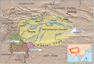
Aksu River (China)
The Aksu River Turkish) is a transboundary river in the Xinjiang province in China and Ak-Suu District of Issyk Kul Province of Kyrgyzstan. In Kyrgyzstan it is known as Saryjaz River . The total length of the river is 282 km, of them 197 km in Kyrgyzstan...
, flowing from the north, and Yarkand River
Yarkand River
The Yarkand River is a river in the Xinjiang Uyghur Autonomous Region of western China. It is one of the headstreams of the Tarim River. It is approximately 970 km in length....
, coming from the southwest, near the Aral City in western Xinjiang. The third river, the Khotan River
Khotan River
The Khotan River is formed by the union of the White Jade and Black Jade Rivers, which flow north from the Kunlun Mountains into the Taklamakan Desert in northern China. The two rivers unite towards the middle of the desert, some north of the town of Khotan...
comes to the same junction area from the south, but it is usually dry at this location, as it has to cross the Taklamakan Desert to get here.
Another river of western Xinjiang is the Kashgar River
Kashgar River
The Kashgar is a river in the Xinjiang province of the China. It has its sources in the eastern parts of the Pamir Mountains, in the border area between China and Tajikistan, and then flows eastwards, passing through the city of Kashgar, which gets its name from the river...
, which falls (at least theoretically, i.e., when it has water in it) into the Yarkand River some 37 km (23 mi) upstream from the Yarkand's merger with the Aksu. By another definition, however, Tarim starts at the Kashgar/Yarkand merger, and Aksu, then, is considered just a tributary of the Tarim.
The Tarim flows in an eastward direction around the northern edge of the Taklamakan Desert. It receives another tributary, the Muzat River
Muzat River
The Muzart River or Muzat River is a river in Aksu Prefecture of Xinjiang Uyghur Autonomous Region, People's Republic of China, a left tributary of the Tarim River...
from the north; however, out of these four rivers (Aksu, Yarkand, Khotan, and Muzart), only the Aksu flows into the Tarim year-round It is the Tarim's most important tributary, supplying 70–80 percent of its water volume.
The word 'tarim' is used to designate the bank of a river that flows into a lake or that is not able to be differentiated from the sands of a desert. This is a characteristic hydrographic feature of many rivers that traverse the sands of the Taklamakan Desert.
Another characteristic of the rivers of the Tarim Basin, including the Tarim River itself, is their active migration, that is, the shifting of their beds and banks.
The total length of the Yarkand-Tarim river system is 2,030 km (1,261 mi), although, as the Tarim frequently changes its channel, the length tends to vary over the years.
It is shallow, unsuitable for navigation,
and because of its heavy silt load, forms a braided stream near its terminus.
Prior to the completion of reservoirs and irrigation works in the mid-20th century, the Tarim's waters eventually reached Lop Nur
Lop Nur
Lop Lake or Lop Nur is a group of small, now seasonal salt lake sand marshes between the Taklamakan and Kuruktag deserts in the Bayingolin Mongol Autonomous Prefecture, southeastern portion of Xinjiang Uygur Autonomous Region in the People's Republic of China.The lake system into which the Tarim...
(now a salt-encrusted lake bed). The
river's waters now drain intermittently into Taitema Lake, which is located about 160 km (100 mi) southwest of Lop Nur. The area of the Tarim River Basin is about 557,000 square km (215,000 square mi). A considerable part of the Tarim's course is unformed, following no clearly defined riverbed. The water volume of the lower course of the river diminishes as a result of extensive evaporation and water-diversion schemes.
The Tarim's low-water period is from October through April. The spring and summer high waters begin in May and continue through September as the snows melt on the distant Tian Shan and Kunlun mountains.
The Lower Tarim Basin is an arid plain composed of alluvium and lake sediments and is bordered by massive mountain ranges. The basin is the driest region of Eurasia
Eurasia
Eurasia is a continent or supercontinent comprising the traditional continents of Europe and Asia ; covering about 52,990,000 km2 or about 10.6% of the Earth's surface located primarily in the eastern and northern hemispheres...
. The predominant part of it is occupied by the Taklamakan Desert, whose sand area exceeds 270,000 square km (105,000 square mi). In addition, there are several comparatively small sand massifs with areas of from 780 to 4,400 square km (300 to 1,700 square mi). Sand dunes are the predominant relief.
Precipitation in the Tarim Basin
Tarim Basin
The Tarim Basin is a large endorheic basin occupying an area of about . It is located in the Xinjiang Uyghur Autonomous Region in China's far west. Its northern boundary is the Tian Shan mountain range and its southern is the Kunlun Mountains on the northern edge of the Tibetan Plateau. The...
is extremely scanty, and in some years it is nonexistent. In the Taklamakan Desert and in the Lop Nur basin, the average annual total of precipitation is about 12 mm (0.5 in). In the foothills and in several other areas of the river's basin, the precipitation amounts to from 50 to 100 mm (2 to 4 inches) a year. In the Tian Shan it is much wetter, precipitation often exceeding 20 inches (500 mm). Maximum temperatures in the Tarim Basin are about 40°C (104°F). The Tarim River freezes over every year from December through March.
Flora and fauna
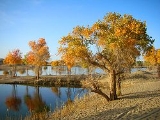
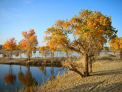
Vegetation in the Tarim Basin is mainly located along the river and its branches. There, at the edge of the sands, shrub like vegetation and stunted trees, especially wormwood, are found. A thin forest of poplarPoplar
Populus is a genus of 25–35 species of deciduous flowering plants in the family Salicaceae, native to most of the Northern Hemisphere. English names variously applied to different species include poplar , aspen, and cottonwood....
grows in the Tarim River valley. Underbrush consists of willows, sea buckthorn, and dense growths of Indian hemp
Indian hemp
Indian hemp may refer to any of various fiber bearing plants:* Apocynum cannabinum* Cannabis indica* Sida rhombifolia* Asclepias incarnata* Hibiscus cannabinus...
and Ural licorice.
The Tarim River is rich in fish, and animal life on the river and the surrounding desert is varied. At the time of Sven Hedin
Sven Hedin
Sven Anders Hedin KNO1kl RVO was a Swedish geographer, topographer, explorer, photographer, and travel writer, as well as an illustrator of his own works...
's visit in 1899, tigers were still being hunted and trapped along the rivers of the region and near Lop Nur
Lop Nur
Lop Lake or Lop Nur is a group of small, now seasonal salt lake sand marshes between the Taklamakan and Kuruktag deserts in the Bayingolin Mongol Autonomous Prefecture, southeastern portion of Xinjiang Uygur Autonomous Region in the People's Republic of China.The lake system into which the Tarim...
. The valley and lakes of the Tarim are a stopover for many migratory birds.
Human use
Despite the Chinese government's promotion of large-scale irrigation, oasis agriculture remains the mainstay of the scattered settlements in the region. Grains, cotton, silk, fruits, and wool are the chief agricultural products, and Khotan jadeJade
Jade is an ornamental stone.The term jade is applied to two different metamorphic rocks that are made up of different silicate minerals:...
s are the only other important item. Little is exported from the basin, but local surpluses find a market among travelers passing through when conditions permit.
Chinese authorities in the northwestern region of Xinjiang are relocating hundreds of ethnic minority farming families along the dwindling Tarim River. By 2008, more than 6,000 households along the river will have been resettled and cultivation forbidden along the river banks, in an attempt to save 60 million cubic meters (16 billion gallons) of water.
History
The Chinese originally considered the Tarim to be the upper course of the Huanghe or Yellow River but, by the time of the Former Han Dynasty (125 BCE-23 CE), it was known that it drains into Lop NurLop Nur
Lop Lake or Lop Nur is a group of small, now seasonal salt lake sand marshes between the Taklamakan and Kuruktag deserts in the Bayingolin Mongol Autonomous Prefecture, southeastern portion of Xinjiang Uygur Autonomous Region in the People's Republic of China.The lake system into which the Tarim...
, a series of salt lakes. Its total length is 2,030 km (or 1,260 mi).
Suggested reading
- Baumer, Christoph. 2000. Southern Silk Road: In the Footsteps of Sir Aurel Stein and Sven Hedin. White Orchid Books. Bangkok.
- Mallory, J.P. and Mair, Victor H. 2000. The Tarim Mummies: Ancient China and the Mystery of the Earliest Peoples from the West. Thames & Hudson. London.
External links
- Information and a map of the Tarim's watershed
- Silk Road Seattle (The Silk Road Seattle website contains many useful resources including a number of full text historical texts)
- Satellite Image Based Map of the Tarim River Basin and Taklamakan Desert + Surrounding Mountain Ranges
- Photos of the Tarim River (from a Xinjiang blog)