
Geography of India
Encyclopedia
The geography of India describes the physical features of India
, a country in South Asia
, that lies entirely on the Indian Plate in the northern portion of the Indo-Australian Plate
. The country lies to the north of the equator between 8°4' and 37°6' north latitude and 68°7' and 97°25' east longitude. It is the seventh-largest country in the world, with a total land area of 3287263 square kilometre. India measures 3214 km (1,997 mi) from north to south and 2993 km (1,860 mi) from east to west. It has a land frontier of 15200 km (9,445 mi) and a coastline of 7517 km (4,671 mi).
India is bounded to the southwest by the Arabian Sea
, to the southeast by the Bay of Bengal
, and to the south by the Indian Ocean
. Kanyakumari is the southern tip of the Indian peninsula. The southernmost point in India is Indira Point
, in the Andaman and Nicobar Islands. The Maldives, Sri Lanka
and Indonesia
are island nations to the south of India. Sri Lanka is separated from India by the Gulf of Mannar
and the narrow channel of Palk Strait
. The territorial waters of India extend into the sea to a distance of 12 nmi (13.8 mi; 22.2 km) measured from the appropriate baseline.
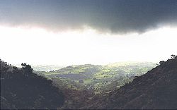
The northern frontiers of India are defined largely by the Himalayan mountain range
, where the country's political boundaries with China, Bhutan
, and Nepal
lie. Its western border with Pakistan lies in the Punjab Plain
and the Thar Desert
. In the far northeast, the Chin Hills
and Kachin Hills
, deeply forested mountainous regions, separate India from Burma. The Bangladesh–India border
is defined by the Khasi hills
and Mizo Hills, and the watershed region of the Indo-Gangetic Plain
.
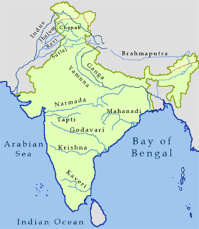
The Ganges is the longest river originating in India. The Ganges, Indus
and Brahmaputra River
s form the Indo-Gangetic Plain
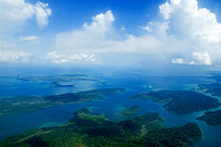
. The Ganges-Brahmaputra system occupies most of northern, central, and eastern India, while the Deccan Plateau
occupies most of southern India. On India's western frontier is the Thar Desert
.
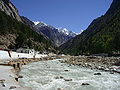
Kangchenjunga
, on the border between Nepal and the Indian state of Sikkim, is the highest point in India at 8598 m (28,209 ft). Climate across India ranges from equatorial in the far south, to alpine
in the upper reaches of the Himalayas.

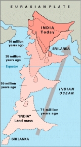
India is entirely contained on the Indian Plate, a major tectonic plate that was formed when it split off from the ancient continent Gondwanaland. About 90 million years ago, during the late Cretaceous Period
, the Indian Plate began moving north at about 15 cm/year (6 in/yr). About 50 to 55 million years ago, in the Eocene Epoch
of the Cenozoic Era
, the plate collided with Asia after covering a distance of 2000 to 3000 km (1,242.7 to 1,864.1 mi), having moved faster than any other known plate. In 2007, German geologists determined that the Indian Plate was able to move so quickly because it is only half as thick as the other plates which formerly constituted Gondwanaland. The collision with the Eurasian Plate
along the modern border between India and Nepal formed the orogenic belt
that created the Tibetan Plateau
and the Himalayas
. , the Indian Plate is moving northeast at 5 cm/yr (2 in/yr), while the Eurasian Plate is moving north at only 2 cm/yr (0.8 in/yr). India is thus referred to as the "fastest continent". This is causing the Eurasian Plate to deform, and the Indian Plate to compress at a rate of 4 mm/yr (0.15 in/yr).
 India's borders run a total length of 15,106.70 km (9,387 mi). Its borders with Pakistan and Bangladesh were delineated according to the Radcliffe Line
, which was created in 1947 during Partition of India
. Its western border with Pakistan extends up to 3,323 km (2,065 mi), dividing the Punjab region
and running along the boundaries of the Thar Desert and the Rann of Kutch
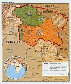
. Both nations delineated a Line of Control
(LoC) to serve as the informal boundary between the Indian and Pakistan-administered areas of Kashmir. According to India's claim, it also shares a 106 km (66 mi) border with Afghanistan in northwestern Kashmir, which is under Pakistani control.
India's border with Bangladesh runs 4,096.70 km (2,546 mi). There are 92 enclaves of Bangladesh on Indian soil and 106 enclaves of India are on Bangladeshi soil. The Teen Bigha Corridor
is a strip of land formerly belonging to India on the West Bengal–Bangladesh border which has been leased indefinitely to Bangladesh so that it can access its Dehgram–Angalpota enclaves
.
The Line of Actual Control
(LAC) is the effective border between India and the People's Republic of China. It traverses 4,057 km along the Indian states of Jammu and Kashmir, Uttarakhand, Himachal Pradesh, Sikkim and Arunachal Pradesh. Both nations lay claim to the Aksai Chin
region of northeastern Kashmir, which fell into Chinese control during the Sino-Indian War
of 1962.The border with Burma (Myanmar) extends up to 1,643 km (1,021 mi) along the southern borders of India's northeastern states. Located amidst the Himalayan range, India's border with Bhutan runs 699 km (434 mi). The border with Nepal runs 1,751 km (1,088 mi) along the foothills of the Himalayas in northern India. The Siliguri Corridor, narrowed sharply by the borders of Bhutan, Nepal and Bangladesh, connects peninsular India with the northeastern states.
. They are
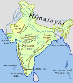
Another method divides India into five physiographic regions: The Himalayas, northern plains (the Indo-Gangetic plain), peninsular region, coastal plains, and islands.
 A great arc of mountains, consisting of the Himalayas, Hindu Kush
, and Patkai
ranges define the northern Indian subcontinent. These were formed by the ongoing tectonic collision of the Indian Plate with the Eurasian Plate
. The mountains in these ranges include some of the world's tallest mountains which act as a natural barrier to cold polar winds. They also facilitate the monsoon
winds which in turn influence the climate in India. Rivers originating in these mountains, flow through the fertile Indo–Gangetic plains. These mountains are recognised by biogeographers
as the boundary between two of the Earth's great ecozones: the temperate
Palearctic
that covers most of Eurasia and the tropical and subtropical Indomalaya
ecozone which includes the Indian subcontinent, Southeast Asia
and Indonesia.
India has eight major mountain ranges having peaks of over 1000 m (3,281 ft):
s dominated by three main rivers, the Indus
, Ganges
, and Brahmaputra. They run parallel to the Himalayas, from Jammu and Kashmir
in the west to Assam
in the east, and drain most of northern and eastern India. The plains encompass an area of 700000 km² (270,271.5 sq mi). The major rivers in this region are the Ganges, Indus, and Brahmaputra along with their main tributaries–Yamuna, Chambal
, Gomti
, Ghaghara
, Kosi, Sutlej, Ravi
, Beas
, Chenab
, and Tista—as well as the rivers of the Ganges Delta
, such as the Meghna
.
The great plains are sometimes classified into four divisions:
The Indo-Gangetic belt is the world's most extensive expanse of uninterrupted alluvium
formed by the deposition of silt
by the numerous rivers. The plains are flat making it conducive for irrigation
through canal
s. The area is also rich in ground water sources.
The plains are one of the world's most intensely farmed
areas. The main crops grown are rice
and wheat
, which are grown in rotation
. Other important crops grown in the region include maize
, sugarcane
and cotton
. The Indo-Gangetic plains rank among the world's most densely populated areas.
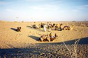
The Thar Desert (also known as the Great Indian Desert) is the world's seventh largest desert, by others the tenth. It forms a significant portion of western India and covers an area of about 200000 km² (77,220.4 sq mi) to about 238700 km² (92,162.6 sq mi). The desert continues into Pakistan as the Cholistan Desert
. Most of the Thar Desert is situated in Rajasthan
, covering 61% of its geographic area.
About 10 percent of this region comprises sand dunes, and the remaining 90 percent consist of craggy rock forms, compacted salt-lake bottoms, and interdunal and fixed dune areas. Annual temperatures can range from 0°C in the winter to over 50°C during the summer. Most of the rainfall received in this region is associated with the short July–September southwest monsoon that brings around 100–500 mm of precipitation. Water is scarce and occurs at great depths, ranging from 30 to 120 m below the ground level. Rainfall is precarious and erratic, ranging from below 120 mm (4.72 inches) in the extreme west to 375 mm (14.75 inches) eastward. The soils of the arid region are generally sandy to sandy-loam in texture. The consistency and depth vary as per the topographical features. The low-lying loams are heavier and may have a hard pan of clay, calcium carbonate
or gypsum
.
in the south (covering most of the Indian peninsula) and the Chota Nagpur Plateau
in the east.
The Malwa Plateau is spread across Rajasthan, Madhya Pradesh and Gujarat. The average elevation of the Malwa plateau is 500 metres, and the landscape generally slopes towards the north. Most of the region is drained by the Chambal River and its tributaries; the western part is drained by the upper reaches of the Mahi River
.
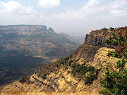
The Deccan Plateau is a large triangular plateau, bounded by the Vindhyas to the north and flanked by the Eastern and Western Ghats. The Deccan covers a total area of 1.9 million km² (735,000 mile²). It is mostly flat, with elevations ranging from 300 to 600 m (1,000 to 2,000 ft). The average elevation of the plateau is 2,000 feet (600 m) above sea level. The surface slopes from 3,000 feet (900 m) in the west to 1,500 feet (450 m) in the east. It slopes gently from west to east and gives rise to several peninsular rivers such as the Godavari
, the Krishna
, the Kaveri and the Narmada
, which drain into the Bay of Bengal. This region is mostly semi-arid as it lies on the leeward side of both Ghats. Much of the Deccan is covered by thorn scrub forest scattered with small regions of deciduous
broadleaf forest. Climate in the Deccan ranges from hot summers to mild winters.
The Chota Nagpur Plateau is situated in eastern India, covering much of Jharkhand and adjacent parts of Orissa, Bihar and Chhattisgarh. Its total area is approximately 65,000 km² (25,000 mile²) and is made up of three smaller plateaus — the Ranchi, Hazaribagh, and Kodarma plateaus. The Ranchi plateau is the largest, with an average elevation of 700 m (2,300 ft). Much of the plateau is forested, covered by the Chota Nagpur dry deciduous forests. Vast reserves of metal ores and coal
have been found in the Chota Nagpur plateau. The Kathiawar
peninsula in western Gujarat is bounded by the Gulf of Kutch and the Gulf of Khambat. The natural vegetation in most of the peninsula is xeric scrub, part of the Northwestern thorn scrub forests
ecoregion.
In western India, the Kutch region in Gujarat and Koyna in Maharashtra are classified as a Zone IV region (high risk) for earthquakes. The Kutch city of Bhuj
was the epicentre of the 2001 Gujarat earthquake
, which claimed the lives of more than 20,000 people and injured 166,836 while destroying or damaging near a million homes. The 1993 Latur earthquake in Maharashtra killed 7,928 people and injured 30,000. Other areas have a moderate to low risk of an earthquake occurring.
 The Eastern Coastal Plain is a wide stretch of land lying between the Eastern Ghats and the Bay of Bengal. It stretches from Tamil Nadu
in the south to West Bengal
in the north. The Mahanadi
, Godavari
, Kaveri, and Krishna
rivers drain these plains and their deltas occupy most of the area. The temperature in the coastal regions often exceeds 30 °C (86 °F), and is coupled with high levels of humidity
. The region receives both the northeast monsoon and southwest monsoon rains. The southwest monsoon splits into two branches, the Bay of Bengal branch and the Arabian Sea branch. The Bay of Bengal branch moves northwards crossing northeast India in early June. The Arabian Sea branch moves northwards and discharges much of its rain on the windward side of Western Ghats. Annual rainfall in this region averages between 1000 and 3000 mm (39.4 and 118.1 in). The width of the plains varies between 100 and 130 km (62.1 and 80.8 mi). The plains are divided into six regions—the Mahanadi delta, the southern Andhra Pradesh plain, the Krishna-Godavari deltas, the Kanyakumari
coast, the Coromandel Coast
, and sandy coastal.
The Western Coastal Plain is a narrow strip of land sandwiched between the Western Ghats and the Arabian Sea, ranging from 50 to 100 km (31.1 to 62.1 mi) in width. It extends from Gujarat in the north and extends through Maharashtra, Goa, Karnataka, and Kerala. Numerous rivers and backwaters inundate the region. Mostly originating in the Western Ghats, the rivers are fast-flowing, usually perennial, and empty ito estuaries
. Major rivers flowing into the sea are the Tapi, Narmada, Mandovi and Zuari. Vegetation is mostly deciduous, but the Malabar Coast moist forests
constitute a unique ecoregion. The Western Coastal Plain can be divided into two parts, the Konkan
and the Malabar Coast
.
The Lakshadweep
and the Andaman and Nicobar Islands are India's two major island formations and are classified as union territories
. The Lakshadweep Islands lie 200 to 300 km (124.3 to 186.4 mi) off the coast of Kerala in the Arabian Sea with an area of 32 km² (12.4 sq mi). They consist of twelve atolls, three reefs, and five submerged banks, with a total of about 36 islands and islets.
The Andaman and Nicobar Islands are located between 6° and 14° north latitude and 92° and 94° east longitude. They consist of 572 isles, lying in the Bay of Bengal near the Myanmar
coast. They are located 1255 km (779.8 mi) from Kolkata
(Calcutta) and 193 km (119.9 mi) from Cape Negrais
in Myanmar. The territory consists of two island groups, the Andaman Islands
and the Nicobar Islands
. The Andaman Islands consists of 204 small islands across a total length of 352 km (218.7 mi). India's only active volcano, Barren Island
is situated here. It last erupted in May 2005. The Narcondum is a dormant volcano and there is a mud volcano
at Baratang
. Indira Point
, India's southernmost land point, is situated in the Nicobar islands, and lies just 189 km (117.4 mi) from the Indonesian island of Sumatra
, to the southeast. The highest point is Mount Thullier
at 642 m (2,106.3 ft).
Other significant islands in India include Diu, a former Portuguese
enclave; Majuli
, a river island of the Brahmaputra; Elephanta
in Bombay Harbour; and Sriharikota
, a barrier island
in Andhra Pradesh. Salsette Island
is India's most populous island on which the city of Mumbai
(Bombay) is located. Forty-two islands in the Gulf of Kutch constitute the Marine National Park
.
India has around 14,500 km of inland navigable waterways. There are twelve rivers which are classified as major rivers, with the total catchment area exceeding 2528000 km² (976,066.3 sq mi). All major rivers of India originate
from one of the three main watersheds
:
The Himalayan river networks are snow-fed and have a perennial supply throughout the year. The other two river systems are dependent on the monsoons and shrink into rivulets during the dry season. The Himalayan rivers that flow westward into Pakistan are the Indus
, Jhelum
, Chenab, Ravi
, Beas
, and Sutlej
.
The Ganges-Brahmaputra
-Meghana
system has the largest catchment area of about 1600000 km² (617,763.5 sq mi). The Ganges Basin alone has a catchment of about 1100000 km² (424,712.4 sq mi). The Ganges originates from the Gangotri Glacier
in Uttarakhand. It flows southeast, draining into the Bay of Bengal. The Yamuna
and Gomti rivers also arise in the western Himalayas and join the Ganges in the plains. The Brahmaputra originates in Tibet
, China
, where it is known as the Yarlung Zangbo River
(or "Tsangpo"). It enters India in the far-eastern state of Arunachal Pradesh
, then flows west through Assam
. The Brahmaputra merges with the Ganges in Bangladesh, where it is known as the Jamuna River.
The Chambal
, another tributary of the Ganges, via the Yamuna, originates from the Vindhya-Satpura watershed. The river flows eastward. Westward-flowing rivers from this watershed are the Narmada
and Tapti, which drain into the Arabian Sea in Gujarat. The river network that flows from east to west constitutes 10% of the total outflow.
 The Western Ghats are the source of all Deccan rivers, which include the Mahanadi River
through the Mahanadi River Delta
, Godavari River
, Krishna River
and Kaveri River
, all draining into the Bay of Bengal. These rivers constitute 20% of India's total outflow.
The heavy southwest monsoon rains cause the Brahmaputra and other rivers to distend their banks, often flooding surrounding areas. Though they provide rice paddy farmers with a largely dependable source of natural irrigation and fertilisation, such floods have killed thousands of people and tend to cause displacements of people in such areas.
Major gulfs include the Gulf of Cambay, Gulf of Kutch
, and the Gulf of Mannar
. Straits include the Palk Strait
, which separates India from Sri Lanka; the Ten Degree Channel
, which separates the Andamans from the Nicobar Islands; and the Eight Degree Channel, which separates the Laccadive and Amindivi Islands from the Minicoy Island to the south. Important capes include the Kanyakumari, the southern tip of mainland India; Indira Point
, the southernmost point in India (on Great Nicobar
Island); Rama's Bridge
, and Point Calimere
. The Arabian Sea lies to the west of India, the Bay of Bengal and the Indian Ocean lie to the east and south, respectively. Smaller seas include the Laccadive Sea
and the Andaman Sea
. There are four coral reef
s in India, located in the Andaman and Nicobar Islands, the Gulf of Mannar, Lakshadweep, and the Gulf of Kutch. Important lakes include Sambhar Lake, the country's largest saltwater lake in Rajasthan, Vembanad Lake
in Kerala, Kolleru Lake
in Andhra Pradesh, Loktak Lake
in Manipur
, Dal Lake
in Kashmir, Chilka Lake
(lagoon lake)in Orrisa, and Sasthamkotta Lake in Kerala.
 India's wetland
ecosystem is widely distributed from the cold and arid located in the Ladakh region of Jammu and Kashmir, and those with the wet and humid climate of peninsular India. Most of the wetlands are directly or indirectly linked to river networks. The Indian government has identified a total of 71 wetlands for conservation and are part of sanctuaries and national parks. Mangrove forests are present all along the Indian coastline in sheltered estuaries, creeks, backwaters, salt marshes and mudflats. The mangrove area covers a total of 4461 square kilometre, which comprises 7% of the world's total mangrove cover. Prominent mangrove covers are located in the Andaman and Nicobar Islands, the Sundarbans
delta, the Gulf of Kutch
and the deltas of the Mahanadi, Godavari and Krishna rivers. Parts of Maharashtra, Karnataka and Kerala also have large mangrove covers.
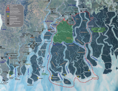
The Sundarbans delta is home to the largest mangrove forest in the world. It lies at the mouth of the Ganges and spreads across areas of Bangladesh and West Bengal. The Sundarbans is a UNESCO
World Heritage Site
, but is identified separately as the Sundarbans (Bangladesh) and the Sundarbans National Park
(India). The Sundarbans are intersected by a complex network of tidal waterways, mudflats and small islands of salt-tolerant mangrove forests. The area is known for its diverse fauna, being home to a large variety of species of birds, spotted deer, crocodiles and snakes. Its most famous inhabitant is the Bengal Tiger
. It is estimated that there are now 400 Bengal tigers and about 30,000 spotted deer in the area.
The Rann of Kutch is a marshy region located in northwestern Gujarat and the bordering Sindh
province of Pakistan. It occupies a total area of 27 900 km² (10,800 mile²). The region was originally a part of the Arabian Sea. Geologic forces such as earthquakes resulted in the damming up of the region, turning it into a large saltwater lagoon. This area gradually filled with silt thus turning it into a seasonal salt marsh. During the monsoons, the area turns into a shallow marsh, often flooding to knee-depth. After the monsoons, the region turns dry and becomes parched.
, India hosts six major climatic subtypes, ranging from arid desert in the west, alpine tundra
and glaciers in the north, and humid tropical regions supporting rainforests in the southwest and the island territories. The nation has four seasons: winter (January–February), summer (March–May), a monsoon (rainy) season (June–September) and a post-monsoon period (October–December).
The Himalayas act as a barrier to the frigid katabatic wind
s flowing down from Central Asia. Thus, North India is kept warm or only mildly cooled during winter; in summer, the same phenomenon makes India relatively hot. Although the Tropic of Cancer
—the boundary between the tropics and subtropics—passes through the middle of India, the whole country is considered to be tropical.
Summer lasts between March and June in most parts of India. Temperatures can exceed 40 °C (104 °F) during the day. The coastal regions exceed 30 °C (86 °F) coupled with high levels of humidity
. In the Thar desert area temperatures can exceed 45 °C (113 °F). The rain-bearing monsoon
clouds are attracted to the low-pressure system created by the Thar Desert. The southwest monsoon splits into two arms, the Bay of Bengal arm and the Arabian Sea arm. The Bay of Bengal arm moves northwards crossing northeast India in early June. The Arabian Sea arm moves northwards and deposits much of its rain on the windward side of Western Ghats. Winters in peninsula India see mild to warm days and cool nights. Further north the temperature is cooler. Temperatures in some parts of the Indian plains sometimes fall below freezing. Most of northern India is plagued by fog during this season. The highest temperature recorded in India was 50.6 °C (123.1 °F) in Alwar in 1955. The lowest was −45 °C in Kashmir.
formations of Cudappah and Vindhyan systems are spread out over the eastern and southern states. A small part of this period is spread over western and central India. The Paleozoic
formations from the Cambrian, Ordovician, Silurian and Devonian system are found in the Western Himalaya region in Kashmir and Himachal Pradesh. The Mesozoic
Deccan Traps
formation is seen over most of the northern Deccan; they are believed to be the result of sub-aerial volcanic activity. The Trap soil is black in colour and conducive to agriculture. The Carboniferous system, Permian System and Triassic systems are seen in the western Himalayas. The Jurassic system is seen in the western Himalayas and Rajasthan.
Tertiary
imprints are seen in parts of Manipur, Nagaland, Arunachal Pradesh and along the Himalayan belt. The Cretaceous system is seen in central India in the Vindhyas and part of the Indo-Gangetic plains. The Gondowana system is seen in the Narmada River area in the Vindhyas and Satpuras. The Eocene system is seen in the western Himalayas and Assam. Oligocene formations are seen in Kutch and Assam. The Pleistocene
system is found over central India. The Andaman and Nicobar Island are thought to have been formed in this era by volcanoes. The Himalayas were formed by the convergence and deformation of the Indo-Australian and Eurasian Plates. Their continued convergence raises the height of the Himalayas by 1 cm each year.
Soils in India can be classified into 8 categories: alluvial, black, red, laterite, forest, arid & desert, saline & alkaline and peaty & organic soils. Alluvial soil constitute the largest soil group in India, constituting 80% of the total land surface. It is derived from the deposition of silt carried by rivers and are found in the Great Northern plains from Punjab to the Assam valley. Alluvial soil are generally fertile but they lack nitrogen and tend to be phosphoric.
Black soil are well developed in the Deccan lava region of Maharashtra, Gujarat, and Madhya Pradesh. These contain high percentage of clay and are moisture retentive. Red soil are found in Tamil Nadu, Karnataka plateau, Andhra plateau, Chota Nagpur plateau and the Aravallis. These are deficient in nitrogen, phosphorus and humus. Laterite soils are formed in tropical regions with heavy rainfall. Heavy rainfall results in leaching out all soluble material of top layer of soil. These are generally found in Western ghats, Eastern ghats and hilly areas of northeastern states that receive heavy rainfall. Forest soils occur on the slopes of mountains and hills in Himalayas, Western Ghats and Eastern Ghats. These generally consist of large amounts of dead leaves and other organic matter called humus.
 India's total renewable water resources are estimated at 1,907.8 km3/year. Its annual supply of usable and replenshable groundwater amounts to 350 billion cubic metres. Only 35% of groundwater resources are being utilised. About 44 million tonnes of cargo is moved annually through the country's major rivers and waterways. Groundwater supplies 40% of water in India's irrigation canals. 56% of the land is arable and used for agriculture. Black soils are moisture-retentive and are preferred for dry farming and growing cotton, linseed, etc. Forest soils are used for tea and coffee plantations. Red soil have a wide diffusion of iron content.
Most of India's estimated 5.4 Goilbbl in oil reserves are located in the Mumbai High, upper Assam, Cambay, the Krishna-Godavari and Cauvery basins. India possesses about seventeen trillion cubic feet of natural gas
in Andhra Pradesh, Gujarat and Orissa. Uranium
is mined in Andhra Pradesh. India has 400 medium-to-high enthalpy thermal springs for producing geothermal energy in seven "provinces" — the Himalayas, Sohana, Cambay, the Narmada-Tapti delta, the Godavari delta and the Andaman and Nicobar Islands (specifically the volcanic Barren Island.)
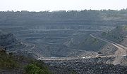
India is the world's biggest producer of mica blocks and mica splittings. India ranks second amongst the world's largest producers of barites and chromites. The Pleistocene system is rich in minerals. India is the third-largest coal producer in the world and ranks fourth in the production of iron ore. It is the fifth-largest producer of bauxite and crude steel, the seventh-largest of manganese ore and the eighth-largest of aluminium. India has significant sources of titanium ore, diamonds and limestone. India possesses 24% of the world's known and economically viable thorium
, which is mined along shores of Kerala. Gold had been mined in the now-defunct Kolar Gold Fields
in Karnataka.
to India is Easter Island
, which is antipodal to the western corner of Rajasthan. The triangular island closely reflects the triangle between the cities of Mokal
, Kuchchri, and Habur. Habur corresponds to Hanga Roa
, and Mokal to the eastern cape.
India
India , officially the Republic of India , is a country in South Asia. It is the seventh-largest country by geographical area, the second-most populous country with over 1.2 billion people, and the most populous democracy in the world...
, a country in South Asia
South Asia
South Asia, also known as Southern Asia, is the southern region of the Asian continent, which comprises the sub-Himalayan countries and, for some authorities , also includes the adjoining countries to the west and the east...
, that lies entirely on the Indian Plate in the northern portion of the Indo-Australian Plate
Indo-Australian Plate
The Indo-Australian Plate is a major tectonic plate that includes the continent of Australia and surrounding ocean, and extends northwest to include the Indian subcontinent and adjacent waters...
. The country lies to the north of the equator between 8°4' and 37°6' north latitude and 68°7' and 97°25' east longitude. It is the seventh-largest country in the world, with a total land area of 3287263 square kilometre. India measures 3214 km (1,997 mi) from north to south and 2993 km (1,860 mi) from east to west. It has a land frontier of 15200 km (9,445 mi) and a coastline of 7517 km (4,671 mi).
India is bounded to the southwest by the Arabian Sea
Arabian Sea
The Arabian Sea is a region of the Indian Ocean bounded on the east by India, on the north by Pakistan and Iran, on the west by the Arabian Peninsula, on the south, approximately, by a line between Cape Guardafui in northeastern Somalia and Kanyakumari in India...
, to the southeast by the Bay of Bengal
Bay of Bengal
The Bay of Bengal , the largest bay in the world, forms the northeastern part of the Indian Ocean. It resembles a triangle in shape, and is bordered mostly by the Eastern Coast of India, southern coast of Bangladesh and Sri Lanka to the west and Burma and the Andaman and Nicobar Islands to the...
, and to the south by the Indian Ocean
Indian Ocean
The Indian Ocean is the third largest of the world's oceanic divisions, covering approximately 20% of the water on the Earth's surface. It is bounded on the north by the Indian Subcontinent and Arabian Peninsula ; on the west by eastern Africa; on the east by Indochina, the Sunda Islands, and...
. Kanyakumari is the southern tip of the Indian peninsula. The southernmost point in India is Indira Point
Indira Point
Indira Point is situated on the island of Great Nicobar in the Nicobar Islands, eastern Indian Ocean, and it represents the southernmost point of land in the territory of India. The point is located in the Union Territory of Andaman and Nicobar Islands and is named in honour of Indira Gandhi...
, in the Andaman and Nicobar Islands. The Maldives, Sri Lanka
Sri Lanka
Sri Lanka, officially the Democratic Socialist Republic of Sri Lanka is a country off the southern coast of the Indian subcontinent. Known until 1972 as Ceylon , Sri Lanka is an island surrounded by the Indian Ocean, the Gulf of Mannar and the Palk Strait, and lies in the vicinity of India and the...
and Indonesia
Indonesia
Indonesia , officially the Republic of Indonesia , is a country in Southeast Asia and Oceania. Indonesia is an archipelago comprising approximately 13,000 islands. It has 33 provinces with over 238 million people, and is the world's fourth most populous country. Indonesia is a republic, with an...
are island nations to the south of India. Sri Lanka is separated from India by the Gulf of Mannar
Gulf of Mannar
The Gulf of Mannar is a large shallow bay forming part of the Laccadive Sea in the Indian Ocean. It lies between the southeastern tip of India and the west coast of Sri Lanka. A chain of low islands and reefs known as Adam's Bridge, also called Ramsethu, which includes Mannar Island, separates the...
and the narrow channel of Palk Strait
Palk Strait
Palk Strait is a strait between the Tamil Nadu state of India and the Mannar district of the Northern Province of the island nation of Sri Lanka. It connects the Bay of Bengal in the northeast with the Palk Bay and thence with the Gulf of Mannar in the southwest. The strait is wide. Several...
. The territorial waters of India extend into the sea to a distance of 12 nmi (13.8 mi; 22.2 km) measured from the appropriate baseline.
The northern frontiers of India are defined largely by the Himalayan mountain range
Himalayas
The Himalaya Range or Himalaya Mountains Sanskrit: Devanagari: हिमालय, literally "abode of snow"), usually called the Himalayas or Himalaya for short, is a mountain range in Asia, separating the Indian subcontinent from the Tibetan Plateau...
, where the country's political boundaries with China, Bhutan
Bhutan
Bhutan , officially the Kingdom of Bhutan, is a landlocked state in South Asia, located at the eastern end of the Himalayas and bordered to the south, east and west by the Republic of India and to the north by the People's Republic of China...
, and Nepal
Nepal
Nepal , officially the Federal Democratic Republic of Nepal, is a landlocked sovereign state located in South Asia. It is located in the Himalayas and bordered to the north by the People's Republic of China, and to the south, east, and west by the Republic of India...
lie. Its western border with Pakistan lies in the Punjab Plain
Punjab Plain
The Punjab Plain is an alluvial plain in the north-west of India. The plain includes the states of Punjab and Haryana and is around in area. The plain is extensively farmed for cereals and cotton....
and the Thar Desert
Thar Desert
The Thar Desert |Punjab]] province. The Cholistan Desert adjoins the Thar desert spreading into Pakistani Punjab province.-Location and description:...
. In the far northeast, the Chin Hills
Chin Hills
The Chin Hills are a range of mountains in Chin State, northwestern Burma , that extends northward into India's Manipur state. They are part of the Arakan Mountain Range . The highest peak in the Chin Hills is Nat Ma Taung, or Khonumthung , in southern Chin State, which reaches 3,053 meters...
and Kachin Hills
Kachin Hills
The Kachin Hills are a heavily forested group of highlands in the extreme northeastern area of the Kachin State of Burma. It includes the Kumon Bum Mountains of which the highest peak is Bumhpa Bum with an elevation of .-Geography:...
, deeply forested mountainous regions, separate India from Burma. The Bangladesh–India border
Bangladesh–India border
Bangladesh and India share a border of 2,429 miles. Bangladeshi Divisions of Khulna, Rajshahi, Rangpur, Mymensingh, Sylhet and Chittagong along with Indian states of West Bengal, Assam, Meghalaya, Tripura and Mizoram are situated along the border. The border is more than blotted with numbered pillars...
is defined by the Khasi hills
Khasi Hills
The Khasi Hills are part of the Garo-Khasi range in the Indian state of Meghalaya, and is part of the Patkai range and of the Meghalaya subtropical forests ecoregion...
and Mizo Hills, and the watershed region of the Indo-Gangetic Plain
Indo-Gangetic plain
The northern Plains also known as the Indo - Gangetic Plain and The North Indian River Plain is a large and fertile plain encompassing most of northern and eastern India, the most populous parts of Pakistan, parts of southern Nepal and virtually all of Bangladesh...
.
The Ganges is the longest river originating in India. The Ganges, Indus
Indus River
The Indus River is a major river which flows through Pakistan. It also has courses through China and India.Originating in the Tibetan plateau of western China in the vicinity of Lake Mansarovar in Tibet Autonomous Region, the river runs a course through the Ladakh district of Jammu and Kashmir and...
and Brahmaputra River
Brahmaputra River
The Brahmaputra , also called Tsangpo-Brahmaputra, is a trans-boundary river and one of the major rivers of Asia. It is the only Indian river that is attributed the masculine gender and thus referred to as a in Indo-Aryan languages and languages with Indo-Aryan influence...
s form the Indo-Gangetic Plain
Indo-Gangetic plain
The northern Plains also known as the Indo - Gangetic Plain and The North Indian River Plain is a large and fertile plain encompassing most of northern and eastern India, the most populous parts of Pakistan, parts of southern Nepal and virtually all of Bangladesh...
. The Ganges-Brahmaputra system occupies most of northern, central, and eastern India, while the Deccan Plateau
Deccan Plateau
The Deccan Plateau is a large plateau in India, making up the majority of the southern part of the country. It rises a hundred meters high in the north, rising further to more than a kilometers high in the south, forming a raised triangle nested within the familiar downward-pointing triangle of...
occupies most of southern India. On India's western frontier is the Thar Desert
Thar Desert
The Thar Desert |Punjab]] province. The Cholistan Desert adjoins the Thar desert spreading into Pakistani Punjab province.-Location and description:...
.
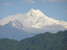
Kangchenjunga
Kangchenjunga
Kangchenjunga is the third highest mountain of the world with an elevation of and located along the India-Nepal border in the Himalayas.Kangchenjunga is also the name of the section of the Himalayas and means "The Five Treasures of Snows", as it contains five peaks, four of them over...
, on the border between Nepal and the Indian state of Sikkim, is the highest point in India at 8598 m (28,209 ft). Climate across India ranges from equatorial in the far south, to alpine
Alpine climate
Alpine climate is the average weather for a region above the tree line. This climate is also referred to as mountain climate or highland climate....
in the upper reaches of the Himalayas.
Geological development
India is entirely contained on the Indian Plate, a major tectonic plate that was formed when it split off from the ancient continent Gondwanaland. About 90 million years ago, during the late Cretaceous Period
Cretaceous
The Cretaceous , derived from the Latin "creta" , usually abbreviated K for its German translation Kreide , is a geologic period and system from circa to million years ago. In the geologic timescale, the Cretaceous follows the Jurassic period and is followed by the Paleogene period of the...
, the Indian Plate began moving north at about 15 cm/year (6 in/yr). About 50 to 55 million years ago, in the Eocene Epoch
Eocene
The Eocene Epoch, lasting from about 56 to 34 million years ago , is a major division of the geologic timescale and the second epoch of the Paleogene Period in the Cenozoic Era. The Eocene spans the time from the end of the Palaeocene Epoch to the beginning of the Oligocene Epoch. The start of the...
of the Cenozoic Era
Cenozoic
The Cenozoic era is the current and most recent of the three Phanerozoic geological eras and covers the period from 65.5 mya to the present. The era began in the wake of the Cretaceous–Tertiary extinction event at the end of the Cretaceous that saw the demise of the last non-avian dinosaurs and...
, the plate collided with Asia after covering a distance of 2000 to 3000 km (1,242.7 to 1,864.1 mi), having moved faster than any other known plate. In 2007, German geologists determined that the Indian Plate was able to move so quickly because it is only half as thick as the other plates which formerly constituted Gondwanaland. The collision with the Eurasian Plate
Eurasian Plate
The Eurasian Plate is a tectonic plate which includes most of the continent of Eurasia , with the notable exceptions of the Indian subcontinent, the Arabian subcontinent, and the area east of the Chersky Range in East Siberia...
along the modern border between India and Nepal formed the orogenic belt
Orogeny
Orogeny refers to forces and events leading to a severe structural deformation of the Earth's crust due to the engagement of tectonic plates. Response to such engagement results in the formation of long tracts of highly deformed rock called orogens or orogenic belts...
that created the Tibetan Plateau
Tibetan Plateau
The Tibetan Plateau , also known as the Qinghai–Tibetan Plateau is a vast, elevated plateau in Central Asia covering most of the Tibet Autonomous Region and Qinghai, in addition to smaller portions of western Sichuan, southwestern Gansu, and northern Yunnan in Western China and Ladakh in...
and the Himalayas
Himalayas
The Himalaya Range or Himalaya Mountains Sanskrit: Devanagari: हिमालय, literally "abode of snow"), usually called the Himalayas or Himalaya for short, is a mountain range in Asia, separating the Indian subcontinent from the Tibetan Plateau...
. , the Indian Plate is moving northeast at 5 cm/yr (2 in/yr), while the Eurasian Plate is moving north at only 2 cm/yr (0.8 in/yr). India is thus referred to as the "fastest continent". This is causing the Eurasian Plate to deform, and the Indian Plate to compress at a rate of 4 mm/yr (0.15 in/yr).
Political geography
India is divided into twenty-eight states (further subdivided into districts) and seven union territories.Radcliffe Line
The Radcliffe Line was announced on 17 August 1947 as a boundary demarcation line between India and Pakistan upon the Partition of India. The Radcliffe Line was named after its architect, Sir Cyril Radcliffe, who as chair of the Border Commissions was tasked with equitably dividing of territory...
, which was created in 1947 during Partition of India
Partition of India
The Partition of India was the partition of British India on the basis of religious demographics that led to the creation of the sovereign states of the Dominion of Pakistan and the Union of India on 14 and 15...
. Its western border with Pakistan extends up to 3,323 km (2,065 mi), dividing the Punjab region
Punjab region
The Punjab , also spelled Panjab |water]]s"), is a geographical region straddling the border between Pakistan and India which includes Punjab province in Pakistan and the states of the Punjab, Haryana, Himachal Pradesh, Chandigarh and some northern parts of the National Capital Territory of Delhi...
and running along the boundaries of the Thar Desert and the Rann of Kutch
Rann of Kutch
The Great Rann of Kutch, also called Greater Rann of Kutch or just Rann of Kutch , is a seasonal salt marsh located in the Thar Desert in the Kutch District of Gujarat, India and the Sindh province of Pakistan....
. Both nations delineated a Line of Control
Line of Control
The term Line of Control refers to the military control line between the Indian- and Pakistani-controlled parts of the former princely state of Jammu and Kashmir—a line which, to this day, does not constitute a legally recognized international boundary but is the de facto border...
(LoC) to serve as the informal boundary between the Indian and Pakistan-administered areas of Kashmir. According to India's claim, it also shares a 106 km (66 mi) border with Afghanistan in northwestern Kashmir, which is under Pakistani control.
India's border with Bangladesh runs 4,096.70 km (2,546 mi). There are 92 enclaves of Bangladesh on Indian soil and 106 enclaves of India are on Bangladeshi soil. The Teen Bigha Corridor
Teen Bigha Corridor
The Tin [or Teen] Bigha Corridor is a strip of land belonging to India on the West Bengal–Bangladesh border, which in September, 2011, was leased to Bangladesh so that it can access its Dahagram–Angarpota enclaves...
is a strip of land formerly belonging to India on the West Bengal–Bangladesh border which has been leased indefinitely to Bangladesh so that it can access its Dehgram–Angalpota enclaves
Indo-Bangladesh enclaves
The Indo-Bangladesh enclaves, also known as the chitmahals are the enclaves along the Bangladesh–India border, in Bangladesh and the Indian state of West Bengal....
.
The Line of Actual Control
Line of Actual Control
The Line of Actual Control is the effective border between India and People's Republic of China . The LAC is 4,057-km long and traverses three areas of northern Indian states: western , middle and eastern...
(LAC) is the effective border between India and the People's Republic of China. It traverses 4,057 km along the Indian states of Jammu and Kashmir, Uttarakhand, Himachal Pradesh, Sikkim and Arunachal Pradesh. Both nations lay claim to the Aksai Chin
Aksai Chin
Aksai Chin is one of the two main disputed border areas between China and India, and the other is South Tibet, which comprises most of India's Arunachal Pradesh. It is administered by China as part of Hotan County in the Hotan Prefecture of Xinjiang Autonomous Region, but is also claimed by India...
region of northeastern Kashmir, which fell into Chinese control during the Sino-Indian War
Sino-Indian War
The Sino-Indian War , also known as the Sino-Indian Border Conflict , was a war between China and India that occurred in 1962. A disputed Himalayan border was the main pretext for war, but other issues played a role. There had been a series of violent border incidents after the 1959 Tibetan...
of 1962.The border with Burma (Myanmar) extends up to 1,643 km (1,021 mi) along the southern borders of India's northeastern states. Located amidst the Himalayan range, India's border with Bhutan runs 699 km (434 mi). The border with Nepal runs 1,751 km (1,088 mi) along the foothills of the Himalayas in northern India. The Siliguri Corridor, narrowed sharply by the borders of Bhutan, Nepal and Bangladesh, connects peninsular India with the northeastern states.
Physiographic regions
India can be divided into six physiographic regionsPhysiographic regions of the world
The physiographic regions of the world are a means of defining the Earth's landforms into distinct regions based upon classic 1916 three-tiered approach defining divisions, provinces, and sections...
. They are
- The Himalayan Mountains
- Northern Plains
- The Great Indian Desert
- The Peninsular Plateau
- Coastal Plains
- Islands
Another method divides India into five physiographic regions: The Himalayas, northern plains (the Indo-Gangetic plain), peninsular region, coastal plains, and islands.
Mountains
Hindu Kush
The Hindu Kush is an mountain range that stretches between central Afghanistan and northern Pakistan. The highest point in the Hindu Kush is Tirich Mir in the Chitral region of Khyber-Pakhtunkhwa, Pakistan.It is the westernmost extension of the Pamir Mountains, the Karakoram Range, and is a...
, and Patkai
Patkai
The Pat-kai meaning to Cut Chicken in Tai Ahom language are the hills on India's North Eastern border with Burma. They were created by the same tectonic processes that resulted in the formation of the Himalayain the Mesozoic . They are not as rugged as the Himalayas and its peaks are much lower...
ranges define the northern Indian subcontinent. These were formed by the ongoing tectonic collision of the Indian Plate with the Eurasian Plate
Eurasian Plate
The Eurasian Plate is a tectonic plate which includes most of the continent of Eurasia , with the notable exceptions of the Indian subcontinent, the Arabian subcontinent, and the area east of the Chersky Range in East Siberia...
. The mountains in these ranges include some of the world's tallest mountains which act as a natural barrier to cold polar winds. They also facilitate the monsoon
Monsoon
Monsoon is traditionally defined as a seasonal reversing wind accompanied by corresponding changes in precipitation, but is now used to describe seasonal changes in atmospheric circulation and precipitation associated with the asymmetric heating of land and sea...
winds which in turn influence the climate in India. Rivers originating in these mountains, flow through the fertile Indo–Gangetic plains. These mountains are recognised by biogeographers
Biogeography
Biogeography is the study of the distribution of species , organisms, and ecosystems in space and through geological time. Organisms and biological communities vary in a highly regular fashion along geographic gradients of latitude, elevation, isolation and habitat area...
as the boundary between two of the Earth's great ecozones: the temperate
Temperate
In geography, temperate or tepid latitudes of the globe lie between the tropics and the polar circles. The changes in these regions between summer and winter are generally relatively moderate, rather than extreme hot or cold...
Palearctic
Palearctic
The Palearctic or Palaearctic is one of the eight ecozones dividing the Earth's surface.Physically, the Palearctic is the largest ecozone...
that covers most of Eurasia and the tropical and subtropical Indomalaya
Indomalaya
The Indomalaya ecozone is one of the eight ecozones that cover the planet's land surface. It extends across most of South and Southeast Asia and into the southern parts of East Asia....
ecozone which includes the Indian subcontinent, Southeast Asia
Southeast Asia
Southeast Asia, South-East Asia, South East Asia or Southeastern Asia is a subregion of Asia, consisting of the countries that are geographically south of China, east of India, west of New Guinea and north of Australia. The region lies on the intersection of geological plates, with heavy seismic...
and Indonesia.
India has eight major mountain ranges having peaks of over 1000 m (3,281 ft):
- The Himalayan range is considered as the world's highest mountain range, with its tallest peak Mt. Everest on the Nepal–China border. They form India's northeastern border, separating it from northeastern Asia. They are one of the world's youngest mountain ranges and extend almost uninterrupted for 2500 km (1,553 mi), covering an area of 500000 square kilometre. The Himalayas extend from Jammu and Kashmir in the north to Arunachal Pradesh in the east. These states along with Himachal Pradesh, Uttarakhand, and Sikkim lie mostly in the Himalayan region. Numerous Himalayan peaks rise over 7000 m (22,966 ft) and the snow lineSnow lineThe climatic snow line is the point above which snow and ice cover the ground throughout the year. The actual snow line may seasonally be significantly lower....
ranges between 6000 m (19,685 ft) in Sikkim to around 3000 m (9,843 ft) in Kashmir. Kanchenjunga—on the SikkimSikkimSikkim is a landlocked Indian state nestled in the Himalayan mountains...
–NepalNepalNepal , officially the Federal Democratic Republic of Nepal, is a landlocked sovereign state located in South Asia. It is located in the Himalayas and bordered to the north by the People's Republic of China, and to the south, east, and west by the Republic of India...
border—is the highest point in the area administered by India. Most peaks in the Himalayas remain snowbound throughout the year. The Himalayas act as a barrier to the frigid katabatic windKatabatic windA katabatic wind, from the Greek word katabatikos meaning "going downhill", is the technical name for a drainage wind, a wind that carries high density air from a higher elevation down a slope under the force of gravity. Such winds are sometimes also called fall winds...
s flowing down from Central Asia. Thus, North India is kept warm or only mildly cooled during winter; in summer, the same phenomenon makes India relatively hot.
- The KarakoramKarakoramThe Karakoram, or Karakorum , is a large mountain range spanning the borders between Pakistan, India and China, located in the regions of Gilgit-Baltistan , Ladakh , and Xinjiang region,...
is situated in the disputed state of Jammu and Kashmir. It has more than sixty peaks above 7000 m (22,966 ft), including K2, the second highest peak in the world 8611 m (28,251 ft). K2 is just 237 m (778 ft) smaller than the 8848 m (29,029 ft) Mount EverestMount EverestMount Everest is the world's highest mountain, with a peak at above sea level. It is located in the Mahalangur section of the Himalayas. The international boundary runs across the precise summit point...
. The range is about 500 km (311 mi) in length and the most heavily glaciatedGlacierA glacier is a large persistent body of ice that forms where the accumulation of snow exceeds its ablation over many years, often centuries. At least 0.1 km² in area and 50 m thick, but often much larger, a glacier slowly deforms and flows due to stresses induced by its weight...
part of the world outside of the polar regions. The Siachen GlacierSiachen GlacierThe Siachen Glacier is located in the eastern Karakoram range in the Himalaya Mountains at about , just east of the Line of Control between India-Pakistan. India controls all of the Siachen Glacier itself, including all tributary glaciers. At long, it is the longest glacier in the Karakoram and...
at 70 km (43 mi) and the Biafo GlacierBiafo GlacierThe Biafo Glacier is a long glacier in the Karakoram Mountains of the Northern Areas, Pakistan which meets the long Hispar Glacier at an altitude of at Hispar La to create the world's longest glacial system outside the polar regions. This highway of ice connects two ancient mountain kingdoms,...
at 63 km (39 mi) rank as the world's second and third-longest glaciers outside the polar regions. Just to the west of the northwest end of the Karakoram, lies the Hindu RajHindu RajThe Hindu Raj is a mountain range in northern Pakistan, between the Hindu Kush and the Karakoram ranges. Its highest peak is Koyo Zom, 6,872 m . Other notable peaks include Buni Zom and Ghamubar Zom. The range is less well-known than its neighbors, partly because of the absence of any 8000 or 7000...
range, beyond which is the Hindu KushHindu KushThe Hindu Kush is an mountain range that stretches between central Afghanistan and northern Pakistan. The highest point in the Hindu Kush is Tirich Mir in the Chitral region of Khyber-Pakhtunkhwa, Pakistan.It is the westernmost extension of the Pamir Mountains, the Karakoram Range, and is a...
range. The southern boundary of the Karakoram is formed by the GilgitGilgit RiverGilgit River is a tributary of the Indus River, and flows past the town of Gilgit. It is located in the Northern Areas of Gilgit-Baltistan, Pakistan. The Gilgit starts from Shandur lake. The Gilgit River is also referred to as the Ghizar River....
, IndusIndus RiverThe Indus River is a major river which flows through Pakistan. It also has courses through China and India.Originating in the Tibetan plateau of western China in the vicinity of Lake Mansarovar in Tibet Autonomous Region, the river runs a course through the Ladakh district of Jammu and Kashmir and...
and Shyok rivers, which separate the range from the northwestern end of the Himalayas.
- The PatkaiPatkaiThe Pat-kai meaning to Cut Chicken in Tai Ahom language are the hills on India's North Eastern border with Burma. They were created by the same tectonic processes that resulted in the formation of the Himalayain the Mesozoic . They are not as rugged as the Himalayas and its peaks are much lower...
, or Purvanchal, are situated near India's eastern border with Myanmar. They were created by the same tectonic processes which led to the formation of the Himalayas. The physical features of the Patkai mountains are conical peaks, steep slopes and deep valleys. The Patkai ranges are not as rugged or tall as the Himalayas. There are three hill ranges that come under the Patkai: the Patkai–Bum, the GaroGaro HillsThe Garo Hills are part of the Garo-Khasi range in Meghalaya, India. They are inhabited mainly by tribal dwellers. Shillong, the capital of Meghalaya, is located in this range. It is one of the wettest places in the world. The range is part of the Meghalaya subtropical forests ecoregion.Garo Hills...
–KhasiKhasi HillsThe Khasi Hills are part of the Garo-Khasi range in the Indian state of Meghalaya, and is part of the Patkai range and of the Meghalaya subtropical forests ecoregion...
–Jaintia and the Lushai hillsLushai hillsThe Lushai Hills are part of the Patkai range in Mizoram and partially in Tripura, India.-Flora & Fauna:The hills are for the most part covered with dense bamboo jungle and rank undergrowth; but in the eastern portion, owing probably to a smaller rainfall, open grass-covered slopes are found, with...
. The Garo–Khasi range lies in Meghalaya. MawsynramMawsynramMawsynram is a village in the East Khasi Hills district of Meghalaya state in north-eastern India, 56 kilometers from Shillong. It is reportedly the wettest place on Earth, with an annual rainfall of...
, a village near CherrapunjiCherrapunjiCherrapunji , is a subdivisional town in the East Khasi Hills district in the Indian state of Meghalaya. It is credited as being the second wettest place on Earth...
lying on the windward side of these hills, has the distinction of being the wettest place in the world, receiving the highest annual rainfall.
- The Vindhya range runs across most of central India, extending 1050 km (652 mi). The average elevation of these hills is 3000 m (9,843 ft). They are believed to have been formed by the wastes created by the weathering of the ancient Aravali mountains. Geographically, it separates northernNorth IndiaNorth India, known natively as Uttar Bhārat or Shumālī Hindustān , is a loosely defined region in the northern part of India. The exact meaning of the term varies by usage...
India from southernSouth IndiaSouth India is the area encompassing India's states of Andhra Pradesh, Karnataka, Kerala and Tamil Nadu as well as the union territories of Lakshadweep and Pondicherry, occupying 19.31% of India's area...
India. The western end of the range lies in eastern Gujarat, near its border with Madhya Pradesh, and runs east and north, almost meeting the Ganges at MirzapurMirzapurMirzapur is a city in the heart of North India, nearly 650 km between Delhi and Kolkata and also equidistant from Allahabad and Varanasi. Located in the state of Uttar Pradesh, Mirzapur has a population of a little over 205,264 and is renowned for its famous carpet and brassware industry...
.
- The Satpura RangeSatpura RangeThe Satpura Range is a range of hills in central India. The range rises in eastern Gujarat state near the Arabian Sea coast, running east through Maharashtra and Madhya Pradesh to Chhattisgarh. The range parallels the Vindhya Range to the north, and these two east-west ranges divide the...
begins in eastern Gujarat near the Arabian Sea coast and runs east across Maharashtra, Madhya Pradesh and Chhattisgarh. It extends 900 km (559 mi) with many peaks rising above 1000 m (3,281 ft). It is triangular in shape, with its apex at RatnapuriRatnapuriRatnapuri is a place in Uttar Pradesh, India.It is the birthplace of the Jain Tirthankara Dharmanath and is a temple town in Uttar Pradesh. It is located on the Ayodhya-Lucknow national highway 24 km west of Ayodhya near Ronahi.-External links:*...
and the two sides being parallel to the TaptiTapti RiverThe Tapi River ancient original name Tapi River , is a river in central India. It is one of the major rivers of peninsular India with a length of around 724 km...
and NarmadaNarmada RiverThe Narmada , also called Rewa is a river in central India and the fifth largest river in the Indian subcontinent. It is the third largest river that completely flows within India after Ganges and Godavari...
rivers. It runs parallel to the Vindhya Range, which lies to the north, and these two east-west ranges divide the Indo–Gangetic plain from the Deccan Plateau located north of River Narmada.
- The Aravali Range is the oldest mountain range in India, running across Rajasthan from northeast to southwest direction, extending approximately 800 km (497 mi). The northern end of the range continues as isolated hills and rocky ridges into HaryanaHaryanaHaryana is a state in India. Historically, it has been a part of the Kuru region in North India. The name Haryana is found mentioned in the 12th century AD by the apabhramsha writer Vibudh Shridhar . It is bordered by Punjab and Himachal Pradesh to the north, and by Rajasthan to the west and south...
, ending near DelhiDelhiDelhi , officially National Capital Territory of Delhi , is the largest metropolis by area and the second-largest by population in India, next to Mumbai. It is the eighth largest metropolis in the world by population with 16,753,265 inhabitants in the Territory at the 2011 Census...
. The highest peak in this range is Guru ShikharGuru ShikharGuru Shikhar, a peak at an altitude of 5,676 feet , is the highest point in Rajasthan. It is located at a distance of 15 km from Mount Abu. It has a commanding view of Abu and its surroundings....
at Mount Abu, rising to 1722 m (5,650 ft), lying near the border with Gujarat. The Aravali Range is the eroded stub of an ancient fold mountainFold mountainFold mountains are mountains formed mainly by the effects of folding on layers within the upper part of the Earth's crust. In the time before either plate tectonic theory developed, or the internal architecture of thrust belts became well understood, the term was used for most mountain belts, such...
system. The range rose in a PrecambrianPrecambrianThe Precambrian is the name which describes the large span of time in Earth's history before the current Phanerozoic Eon, and is a Supereon divided into several eons of the geologic time scale...
event called the Aravali–Delhi orogen. The range joins two of the ancient segments that make up the Indian cratonCratonA craton is an old and stable part of the continental lithosphere. Having often survived cycles of merging and rifting of continents, cratons are generally found in the interiors of tectonic plates. They are characteristically composed of ancient crystalline basement rock, which may be covered by...
, the MarwarMarwarMarwar is a region of southwestern Rajasthan state in western India. It lies partly in the Thar Desert. In Rajasthani dialect "wad" means a particular area. The word Marwar is derived from Sanskrit word 'Maruwat'. English translation of the word is 'The region of desert'., The Imperial Gazetteer...
segment to the northwest of the range, and the Bundelkhand segment to the southeast.
- The Western GhatsWestern GhatsThe Western Ghats, Western Ghauts or the Sahyādri is a mountain range along the western side of India. It runs north to south along the western edge of the Deccan Plateau, and separates the plateau from a narrow coastal plain along the Arabian Sea. The Western Ghats block rainfall to the Deccan...
or Sahyadri mountains run along the western edge of India's Deccan PlateauDeccan PlateauThe Deccan Plateau is a large plateau in India, making up the majority of the southern part of the country. It rises a hundred meters high in the north, rising further to more than a kilometers high in the south, forming a raised triangle nested within the familiar downward-pointing triangle of...
and separate it from a narrow coastal plain along the Arabian SeaArabian SeaThe Arabian Sea is a region of the Indian Ocean bounded on the east by India, on the north by Pakistan and Iran, on the west by the Arabian Peninsula, on the south, approximately, by a line between Cape Guardafui in northeastern Somalia and Kanyakumari in India...
. The range runs approximately 1600 km (994 mi) from south of the Tapti RiverTapti RiverThe Tapi River ancient original name Tapi River , is a river in central India. It is one of the major rivers of peninsular India with a length of around 724 km...
near the Gujarat–Maharashtra border and across Maharashtra, Goa, Karnataka, Kerala and Tamil Nadu to the southern tip of the Deccan peninsula. The average elevation is around 1000 m (3,281 ft). Anai Mudi in the Anaimalai HillsAnaimalai HillsThe Anaimalai Hills is a range of mountains in the Western Ghats in Tamil Nadu and Kerala states of South India. The name "Anaimalai" derives from the Tamil word 'Ana' meaning elephant and 'Mala' meaning hill, thus Elephant Hill. The highest peak of the Anaimalai Hills is Anamudi, , located in the...
2695 m (8,842 ft) in Kerala is the highest peak in the Western Ghats.
- The Eastern GhatsEastern GhatsThe Eastern Ghats or Eastern Ghauts are a discontinuous range of mountains along India's eastern coast. The Eastern Ghats run from West Bengal state in the north, through Orissa and Andhra Pradesh to Tamil Nadu in the south passing some parts of Karnataka. They are eroded and cut through by the...
are a discontinuous range of mountains, which have been eroded and vivisected by the four major rivers of southern India, the GodavariGodavari RiverThe Godavari is a river that runs from western to southern India and is considered to be one of the big river basins in India. With a length of 1465 km, it is the second longest river in India , that runs within the country and also the longest river in South India...
, MahanadiMahanadi RiverThe Mahanadi in East Central India. It drains an area of around 141,600 km2 and has a total course of 858 km. The river flows through the states of Chhattisgarh and Orissa.-Source:...
, KrishnaKrishna RiverThe Krishna River , is one of the longest rivers in central-southern India, about . It is also referred to as Krishnaveni in its original nomenclature...
, and KaveriKaveri RiverThe Kaveri , also spelled Cauvery in English, is a large Indian river. The origin of the river is traditionally placed at Talakaveri, Kodagu in the Western Ghats in Karnataka, flows generally south and east through Karnataka and Tamil Nadu and across the southern Deccan plateau through the...
. These mountains extend from West Bengal to Orissa, Andhra Pradesh and Tamil Nadu, along the coast and parallel to the Bay of Bengal. Though not as tall as the Western Ghats, some of its peaks are over 1000 m (3,281 ft) in height. The Nilgiri hills in Tamil Nadu lies at the junction of the Eastern and Western Ghats. Jindagada Peak (1657m), near Araku Valley of Andhra Pradesh, is the tallest peak in Eastern Ghats.
Indo-Gangetic plain
The Indo-Gangetic plains, also known as the Great Plains are large alluvial plainAlluvial plain
An alluvial plain is a relatively flat landform created by the deposition of sediment over a long period of time by one or more rivers coming from highland regions, from which alluvial soil forms...
s dominated by three main rivers, the Indus
Indus River
The Indus River is a major river which flows through Pakistan. It also has courses through China and India.Originating in the Tibetan plateau of western China in the vicinity of Lake Mansarovar in Tibet Autonomous Region, the river runs a course through the Ladakh district of Jammu and Kashmir and...
, Ganges
Ganges River
The Ganges or Ganga, , is a trans-boundary river of India and Bangladesh. The river rises in the western Himalayas in the Indian state of Uttarakhand, and flows south and east through the Gangetic Plain of North India into Bangladesh, where it empties into the Bay of Bengal. By discharge it...
, and Brahmaputra. They run parallel to the Himalayas, from Jammu and Kashmir
Jammu and Kashmir
Jammu and Kashmir is the northernmost state of India. It is situated mostly in the Himalayan mountains. Jammu and Kashmir shares a border with the states of Himachal Pradesh and Punjab to the south and internationally with the People's Republic of China to the north and east and the...
in the west to Assam
Assam
Assam , also, rarely, Assam Valley and formerly the Assam Province , is a northeastern state of India and is one of the most culturally and geographically distinct regions of the country...
in the east, and drain most of northern and eastern India. The plains encompass an area of 700000 km² (270,271.5 sq mi). The major rivers in this region are the Ganges, Indus, and Brahmaputra along with their main tributaries–Yamuna, Chambal
Chambal River
The Chambal River is a tributary of the Yamuna River in central India, and forms part of the greater Gangetic drainage system. The river flows north-northeast through Madhya Pradesh, running for a time through Rajasthan, then forming the boundary between Rajasthan and Madhya Pradesh before turning...
, Gomti
Gomti River
The Gomti, Gumti or Gomati River is a tributary of the Ganges River. According to Hindu mythology the river is the daughter of Sage Vashist, and bathing in the waters of the Gomati on Ekadashi can wash away one's sins...
, Ghaghara
Ghaghara River
Karnali or Ghaghara is a perennial trans-boundary river originating on the Tibetan Plateau near Lake Mansarovar. It cuts through the Himalayas in Nepal and joins the Sarda River at Brahmaghat in India. Together they form the Ghaghra River, a major left bank tributary of the Ganges. With a length of...
, Kosi, Sutlej, Ravi
Ravi River
The Ravi is a trans-boundary river flowing through Northwestern India and eastern Pakistan. It is one of the six rivers of the Indus System in Punjab region ....
, Beas
Beas River
The Beas River is a river in the northern part of India. The river rises in the Himalayas in central Himachal Pradesh, India, and flows for some 470 km to the Sutlej River in the Indian state of Punjab....
, Chenab
Chenab River
The Chenab River چنRiver' آب) is a major river of Jammu and Kashmir and the Punjab in Pakistan. It forms in the upper Himalayas in the Lahaul and Spiti district of Himachal Pradesh, India, and flows through the Jammu region of Jammu and Kashmir into the plains of the Punjab, Pakistan...
, and Tista—as well as the rivers of the Ganges Delta
Ganges Delta
The Ganges Delta is a river delta in the South Asia region of Bengal, consisting of Bangladesh and the state of West Bengal, India. It is the world's largest delta, and empties into the Bay of Bengal...
, such as the Meghna
Meghna River
The Meghna River is an important river in Bangladesh, one of the three that forms the Ganges Delta, the largest on earth fanning out to the Bay of Bengal. Being a part of the Surma-Meghna River System, Meghna is formed inside Bangladesh by the joining of different rivers originaing from the hilly...
.
The great plains are sometimes classified into four divisions:
- The BhabarBhabharBhabhar is the region south of the Lower Himalayas and the Siwalik Hills It is the alluvial apron of sediments washed down from the Siwaliks along the northern edge of the Indo-Gangetic Plain.-Etymology:...
belt is adjacent to the foothills of the Himalayas and consists of boulders and pebbles which have been carried down by streams. As the porosityPorosityPorosity or void fraction is a measure of the void spaces in a material, and is a fraction of the volume of voids over the total volume, between 0–1, or as a percentage between 0–100%...
of this belt is very high, the streams flow underground. The Bhabar is generally narrow with its width varying between 7 to 15 km. - The TeraiTeraiThe Terai is a belt of marshy grasslands, savannas, and forests located south of the outer foothills of the Himalaya, the Siwalik Hills, and north of the Indo-Gangetic Plain of the Ganges, Brahmaputra and their tributaries. The Terai belongs to the Terai-Duar savanna and grasslands ecoregion...
belt lies south of the adjacent Bhabar region and is composed of newer alluvium. The underground streams reappear in this region. The region is excessively moist and thickly forested. It also receives heavy rainfall throughout the year and is populated with a variety of wildlife. - The Bangar belt consists of older alluvium and forms the alluvial terrace of the flood plains. In the Gangetic plains, it has a low upland covered by laterite deposits.
- The Khadar belt lies in lowland areas after the Bangar belt. It is made up of fresh newer alluvium which is deposited by the rivers flowing down the plain.
The Indo-Gangetic belt is the world's most extensive expanse of uninterrupted alluvium
Alluvium
Alluvium is loose, unconsolidated soil or sediments, eroded, deposited, and reshaped by water in some form in a non-marine setting. Alluvium is typically made up of a variety of materials, including fine particles of silt and clay and larger particles of sand and gravel...
formed by the deposition of silt
Silt
Silt is granular material of a size somewhere between sand and clay whose mineral origin is quartz and feldspar. Silt may occur as a soil or as suspended sediment in a surface water body...
by the numerous rivers. The plains are flat making it conducive for irrigation
Irrigation
Irrigation may be defined as the science of artificial application of water to the land or soil. It is used to assist in the growing of agricultural crops, maintenance of landscapes, and revegetation of disturbed soils in dry areas and during periods of inadequate rainfall...
through canal
Canal
Canals are man-made channels for water. There are two types of canal:#Waterways: navigable transportation canals used for carrying ships and boats shipping goods and conveying people, further subdivided into two kinds:...
s. The area is also rich in ground water sources.
The plains are one of the world's most intensely farmed
Intensive farming
Intensive farming or intensive agriculture is an agricultural production system characterized by the high inputs of capital, labour, or heavy usage of technologies such as pesticides and chemical fertilizers relative to land area....
areas. The main crops grown are rice
Rice
Rice is the seed of the monocot plants Oryza sativa or Oryza glaberrima . As a cereal grain, it is the most important staple food for a large part of the world's human population, especially in East Asia, Southeast Asia, South Asia, the Middle East, and the West Indies...
and wheat
Wheat
Wheat is a cereal grain, originally from the Levant region of the Near East, but now cultivated worldwide. In 2007 world production of wheat was 607 million tons, making it the third most-produced cereal after maize and rice...
, which are grown in rotation
Crop rotation
Crop rotation is the practice of growing a series of dissimilar types of crops in the same area in sequential seasons.Crop rotation confers various benefits to the soil. A traditional element of crop rotation is the replenishment of nitrogen through the use of green manure in sequence with cereals...
. Other important crops grown in the region include maize
Maize
Maize known in many English-speaking countries as corn or mielie/mealie, is a grain domesticated by indigenous peoples in Mesoamerica in prehistoric times. The leafy stalk produces ears which contain seeds called kernels. Though technically a grain, maize kernels are used in cooking as a vegetable...
, sugarcane
Sugarcane
Sugarcane refers to any of six to 37 species of tall perennial grasses of the genus Saccharum . Native to the warm temperate to tropical regions of South Asia, they have stout, jointed, fibrous stalks that are rich in sugar, and measure two to six metres tall...
and cotton
Cotton
Cotton is a soft, fluffy staple fiber that grows in a boll, or protective capsule, around the seeds of cotton plants of the genus Gossypium. The fiber is almost pure cellulose. The botanical purpose of cotton fiber is to aid in seed dispersal....
. The Indo-Gangetic plains rank among the world's most densely populated areas.
Thar Desert
The Thar Desert (also known as the Great Indian Desert) is the world's seventh largest desert, by others the tenth. It forms a significant portion of western India and covers an area of about 200000 km² (77,220.4 sq mi) to about 238700 km² (92,162.6 sq mi). The desert continues into Pakistan as the Cholistan Desert
Cholistan Desert
Cholistan Desert sprawls thirty kilometers from Bahawalpur, Punjab, Pakistan and covers an area of 26,300 km². It adjoins the Thar Desert extending over to Sindh and into India....
. Most of the Thar Desert is situated in Rajasthan
Rajasthan
Rājasthān the land of Rajasthanis, , is the largest state of the Republic of India by area. It is located in the northwest of India. It encompasses most of the area of the large, inhospitable Great Indian Desert , which has an edge paralleling the Sutlej-Indus river valley along its border with...
, covering 61% of its geographic area.
About 10 percent of this region comprises sand dunes, and the remaining 90 percent consist of craggy rock forms, compacted salt-lake bottoms, and interdunal and fixed dune areas. Annual temperatures can range from 0°C in the winter to over 50°C during the summer. Most of the rainfall received in this region is associated with the short July–September southwest monsoon that brings around 100–500 mm of precipitation. Water is scarce and occurs at great depths, ranging from 30 to 120 m below the ground level. Rainfall is precarious and erratic, ranging from below 120 mm (4.72 inches) in the extreme west to 375 mm (14.75 inches) eastward. The soils of the arid region are generally sandy to sandy-loam in texture. The consistency and depth vary as per the topographical features. The low-lying loams are heavier and may have a hard pan of clay, calcium carbonate
Calcium carbonate
Calcium carbonate is a chemical compound with the formula CaCO3. It is a common substance found in rocks in all parts of the world, and is the main component of shells of marine organisms, snails, coal balls, pearls, and eggshells. Calcium carbonate is the active ingredient in agricultural lime,...
or gypsum
Gypsum
Gypsum is a very soft sulfate mineral composed of calcium sulfate dihydrate, with the chemical formula CaSO4·2H2O. It is found in alabaster, a decorative stone used in Ancient Egypt. It is the second softest mineral on the Mohs Hardness Scale...
.
Highlands
The Central Highlands comprise of three main plateaus — the Malwa Plateau in the west, the Deccan PlateauDeccan Plateau
The Deccan Plateau is a large plateau in India, making up the majority of the southern part of the country. It rises a hundred meters high in the north, rising further to more than a kilometers high in the south, forming a raised triangle nested within the familiar downward-pointing triangle of...
in the south (covering most of the Indian peninsula) and the Chota Nagpur Plateau
Chota Nagpur Plateau
The Chota Nagpur Plateau is a plateau in eastern India, which covers much of Jharkhand state as well as adjacent parts of Orissa, West Bengal, Bihar and Chhattisgarh. The Indo-Gangetic plain lies to the north and east of the plateau, and the basin of the Mahanadi River lies to the south...
in the east.
The Malwa Plateau is spread across Rajasthan, Madhya Pradesh and Gujarat. The average elevation of the Malwa plateau is 500 metres, and the landscape generally slopes towards the north. Most of the region is drained by the Chambal River and its tributaries; the western part is drained by the upper reaches of the Mahi River
Mahi River
The Mahi is a river in western India. It rises in Madhya Pradesh and, after flowing through the Vagad region of Rajasthan, enters Gujarat and falls into the sea by a wide estuary near Khambhat. Its total length is 500 km. and its estimated drainage area 40,000 km2...
.
The Deccan Plateau is a large triangular plateau, bounded by the Vindhyas to the north and flanked by the Eastern and Western Ghats. The Deccan covers a total area of 1.9 million km² (735,000 mile²). It is mostly flat, with elevations ranging from 300 to 600 m (1,000 to 2,000 ft). The average elevation of the plateau is 2,000 feet (600 m) above sea level. The surface slopes from 3,000 feet (900 m) in the west to 1,500 feet (450 m) in the east. It slopes gently from west to east and gives rise to several peninsular rivers such as the Godavari
Godavari River
The Godavari is a river that runs from western to southern India and is considered to be one of the big river basins in India. With a length of 1465 km, it is the second longest river in India , that runs within the country and also the longest river in South India...
, the Krishna
Krishna River
The Krishna River , is one of the longest rivers in central-southern India, about . It is also referred to as Krishnaveni in its original nomenclature...
, the Kaveri and the Narmada
Narmada River
The Narmada , also called Rewa is a river in central India and the fifth largest river in the Indian subcontinent. It is the third largest river that completely flows within India after Ganges and Godavari...
, which drain into the Bay of Bengal. This region is mostly semi-arid as it lies on the leeward side of both Ghats. Much of the Deccan is covered by thorn scrub forest scattered with small regions of deciduous
Deciduous
Deciduous means "falling off at maturity" or "tending to fall off", and is typically used in reference to trees or shrubs that lose their leaves seasonally, and to the shedding of other plant structures such as petals after flowering or fruit when ripe...
broadleaf forest. Climate in the Deccan ranges from hot summers to mild winters.
The Chota Nagpur Plateau is situated in eastern India, covering much of Jharkhand and adjacent parts of Orissa, Bihar and Chhattisgarh. Its total area is approximately 65,000 km² (25,000 mile²) and is made up of three smaller plateaus — the Ranchi, Hazaribagh, and Kodarma plateaus. The Ranchi plateau is the largest, with an average elevation of 700 m (2,300 ft). Much of the plateau is forested, covered by the Chota Nagpur dry deciduous forests. Vast reserves of metal ores and coal
Coal
Coal is a combustible black or brownish-black sedimentary rock usually occurring in rock strata in layers or veins called coal beds or coal seams. The harder forms, such as anthracite coal, can be regarded as metamorphic rock because of later exposure to elevated temperature and pressure...
have been found in the Chota Nagpur plateau. The Kathiawar
Kathiawar
Kathiawar or Kathiawad is a peninsula in western India, which is part of the Saurashtra region on the Arabian Sea coast of Gujarat state. It is bounded on the north by the great wetland of the Rann of Kutch, on the northwest by the Gulf of Kutch, on the west and south by the Arabian Sea, and on...
peninsula in western Gujarat is bounded by the Gulf of Kutch and the Gulf of Khambat. The natural vegetation in most of the peninsula is xeric scrub, part of the Northwestern thorn scrub forests
Northwestern thorn scrub forests
The Northwestern thorn scrub forests are a xeric shrubland ecoregion of Pakistan and northwestern India, a region of extreme temperatures and a very climate that was once covered in deciduous forest.-Location and description:...
ecoregion.
In western India, the Kutch region in Gujarat and Koyna in Maharashtra are classified as a Zone IV region (high risk) for earthquakes. The Kutch city of Bhuj
Bhuj
Bhuj is a city and a municipality in Kachchh district in the state of Gujarat, India.-History:It was established by Rao Hamirji in 1510 and was made the state capital by Rao Khengarji I in 1549. Its foundation stone as state capital laid formally on Vikram Samvat 1604 Maagha 5th...
was the epicentre of the 2001 Gujarat earthquake
2001 Gujarat earthquake
The 2001 Gujarat earthquake occurred on January 26, 2001, India's 52nd Republic Day, at 08:46 AM local time and lasted for over two minutes. The epicentre was about 9 km south-southwest of the village of Chobari in Bhachau Taluka of Kutch District of Gujarat, India...
, which claimed the lives of more than 20,000 people and injured 166,836 while destroying or damaging near a million homes. The 1993 Latur earthquake in Maharashtra killed 7,928 people and injured 30,000. Other areas have a moderate to low risk of an earthquake occurring.
Coasts
Tamil Nadu
Tamil Nadu is one of the 28 states of India. Its capital and largest city is Chennai. Tamil Nadu lies in the southernmost part of the Indian Peninsula and is bordered by the union territory of Pondicherry, and the states of Kerala, Karnataka, and Andhra Pradesh...
in the south to West Bengal
West Bengal
West Bengal is a state in the eastern region of India and is the nation's fourth-most populous. It is also the seventh-most populous sub-national entity in the world, with over 91 million inhabitants. A major agricultural producer, West Bengal is the sixth-largest contributor to India's GDP...
in the north. The Mahanadi
Mahanadi River
The Mahanadi in East Central India. It drains an area of around 141,600 km2 and has a total course of 858 km. The river flows through the states of Chhattisgarh and Orissa.-Source:...
, Godavari
Godavari River
The Godavari is a river that runs from western to southern India and is considered to be one of the big river basins in India. With a length of 1465 km, it is the second longest river in India , that runs within the country and also the longest river in South India...
, Kaveri, and Krishna
Krishna
Krishna is a central figure of Hinduism and is traditionally attributed the authorship of the Bhagavad Gita. He is the supreme Being and considered in some monotheistic traditions as an Avatar of Vishnu...
rivers drain these plains and their deltas occupy most of the area. The temperature in the coastal regions often exceeds 30 °C (86 °F), and is coupled with high levels of humidity
Humidity
Humidity is a term for the amount of water vapor in the air, and can refer to any one of several measurements of humidity. Formally, humid air is not "moist air" but a mixture of water vapor and other constituents of air, and humidity is defined in terms of the water content of this mixture,...
. The region receives both the northeast monsoon and southwest monsoon rains. The southwest monsoon splits into two branches, the Bay of Bengal branch and the Arabian Sea branch. The Bay of Bengal branch moves northwards crossing northeast India in early June. The Arabian Sea branch moves northwards and discharges much of its rain on the windward side of Western Ghats. Annual rainfall in this region averages between 1000 and 3000 mm (39.4 and 118.1 in). The width of the plains varies between 100 and 130 km (62.1 and 80.8 mi). The plains are divided into six regions—the Mahanadi delta, the southern Andhra Pradesh plain, the Krishna-Godavari deltas, the Kanyakumari
Kanyakumari
Kanyakumari is a town in the state of Tamil Nadu in India. It is also sometimes referred to as Cape Comorin. Located at the southernmost tip of the Indian Peninsula, it is the geographical end of the Indian mainland. The district in Tamil Nadu where the town is located is called Kanyakumari...
coast, the Coromandel Coast
Coromandel Coast
The Coromandel Coast is the name given to the southeastern coast of the Indian Subcontinent between Cape Comorin and False Divi Point...
, and sandy coastal.
The Western Coastal Plain is a narrow strip of land sandwiched between the Western Ghats and the Arabian Sea, ranging from 50 to 100 km (31.1 to 62.1 mi) in width. It extends from Gujarat in the north and extends through Maharashtra, Goa, Karnataka, and Kerala. Numerous rivers and backwaters inundate the region. Mostly originating in the Western Ghats, the rivers are fast-flowing, usually perennial, and empty ito estuaries
Estuary
An estuary is a partly enclosed coastal body of water with one or more rivers or streams flowing into it, and with a free connection to the open sea....
. Major rivers flowing into the sea are the Tapi, Narmada, Mandovi and Zuari. Vegetation is mostly deciduous, but the Malabar Coast moist forests
Malabar Coast moist forests
The Malabar Coast moist forests is a tropical moist broadleaf forest ecoregion of southwestern India. It lies along India's Konkan and Malabar coasts, in a narrow strip between the Arabian Sea and the Western Ghats range, which runs parallel to the coast...
constitute a unique ecoregion. The Western Coastal Plain can be divided into two parts, the Konkan
Konkan
The Konkan also called the Konkan Coast or Karavali is a rugged section of the western coastline of India from Raigad to Mangalore...
and the Malabar Coast
Malabar Coast
The Malabar Coast is a long and narrow coastline on the south-western shore line of the mainland Indian subcontinent. Geographically, it comprises the wettest regions of southern India, as the Western Ghats intercept the moisture-laden monsoon rains, especially on their westward-facing mountain...
.
Islands
The Lakshadweep
Lakshadweep
Lakshadweep , formerly known as the Laccadive, Minicoy, and Amindivi Islands, is a group of islands in the Laccadive Sea, 200 to 440 km off the coast of the South West Indian state of Kerala...
and the Andaman and Nicobar Islands are India's two major island formations and are classified as union territories
Union Territory
A Union Territory is a sub-national administrative division of India, in the federal framework of governance. Unlike the states of India, which have their own elected governments, union territories are ruled directly by the federal government; the President of India appoints an Administrator or...
. The Lakshadweep Islands lie 200 to 300 km (124.3 to 186.4 mi) off the coast of Kerala in the Arabian Sea with an area of 32 km² (12.4 sq mi). They consist of twelve atolls, three reefs, and five submerged banks, with a total of about 36 islands and islets.
The Andaman and Nicobar Islands are located between 6° and 14° north latitude and 92° and 94° east longitude. They consist of 572 isles, lying in the Bay of Bengal near the Myanmar
Myanmar
Burma , officially the Republic of the Union of Myanmar , is a country in Southeast Asia. Burma is bordered by China on the northeast, Laos on the east, Thailand on the southeast, Bangladesh on the west, India on the northwest, the Bay of Bengal to the southwest, and the Andaman Sea on the south....
coast. They are located 1255 km (779.8 mi) from Kolkata
Kolkata
Kolkata , formerly known as Calcutta, is the capital of the Indian state of West Bengal. Located on the east bank of the Hooghly River, it was the commercial capital of East India...
(Calcutta) and 193 km (119.9 mi) from Cape Negrais
Cape Negrais
Cape Negrais is a cape in Burma , 193 kilometres from the Indian union territory of the Andaman and Nicobar Islands....
in Myanmar. The territory consists of two island groups, the Andaman Islands
Andaman Islands
The Andaman Islands are a group of Indian Ocean archipelagic islands in the Bay of Bengal between India to the west, and Burma , to the north and east...
and the Nicobar Islands
Nicobar Islands
The Nicobar Islands are an archipelagic island chain in the eastern Indian Ocean...
. The Andaman Islands consists of 204 small islands across a total length of 352 km (218.7 mi). India's only active volcano, Barren Island
Barren Island (Andaman Islands)
Barren Island is located in the Andaman Sea, one of the most easterly of the Andaman Islands. It is the only confirmed active volcano in South Asia...
is situated here. It last erupted in May 2005. The Narcondum is a dormant volcano and there is a mud volcano
Mud volcano
The term mud volcano or mud dome are used to refer to formations created by geo-excreted liquids and gases, although there are several different processes which may cause such activity. Hot water mixes with mud and surface deposits. Mud volcanoes are associated with subduction zones and about 700...
at Baratang
Baratang
Baratang, less commonly known as Baratang Island, is an island in the Andaman Islands, India, with an area of approximately . It is one of the main islands of the Great Andaman group, a closely set archipelago in the Bay of Bengal, adjoining the Andaman Sea. Middle Andaman is to its north, and...
. Indira Point
Indira Point
Indira Point is situated on the island of Great Nicobar in the Nicobar Islands, eastern Indian Ocean, and it represents the southernmost point of land in the territory of India. The point is located in the Union Territory of Andaman and Nicobar Islands and is named in honour of Indira Gandhi...
, India's southernmost land point, is situated in the Nicobar islands, and lies just 189 km (117.4 mi) from the Indonesian island of Sumatra
Sumatra
Sumatra is an island in western Indonesia, westernmost of the Sunda Islands. It is the largest island entirely in Indonesia , and the sixth largest island in the world at 473,481 km2 with a population of 50,365,538...
, to the southeast. The highest point is Mount Thullier
Mount Thullier
Mount Thuillier is the highest point in the Nicobar Islands, located in the Indian Ocean and bordering on the Andaman Sea. The mount is located on the island of Great Nicobar, measuring 642 m above mean sea level....
at 642 m (2,106.3 ft).
Other significant islands in India include Diu, a former Portuguese
Portugal
Portugal , officially the Portuguese Republic is a country situated in southwestern Europe on the Iberian Peninsula. Portugal is the westernmost country of Europe, and is bordered by the Atlantic Ocean to the West and South and by Spain to the North and East. The Atlantic archipelagos of the...
enclave; Majuli
Majuli
200px|thumb|Way To Majuli From [[Jorhat]] City Majuli or Majoli is a large river island in the Brahmaputra river, in the Indian state of Assam...
, a river island of the Brahmaputra; Elephanta
Elephanta Island
Elephanta Island is one of a number of islands in Mumbai Harbour, east of Mumbai, India...
in Bombay Harbour; and Sriharikota
Sriharikota
Sriharikota is a barrier island off the coast of the southern state of Andhra Pradesh in India. It houses India's only satellite launch centre in the Satish Dhawan Space Centre and is used by the Indian Space Research Organisation to launch satellites using multi-stage rockets such as the Polar...
, a barrier island
Barrier island
Barrier islands, a coastal landform and a type of barrier system, are relatively narrow strips of sand that parallel the mainland coast. They usually occur in chains, consisting of anything from a few islands to more than a dozen...
in Andhra Pradesh. Salsette Island
Salsette Island
Salsette Island is an island in Maharashtra state on India's west coast. The metropolis of Mumbai and the city of Thane lie on this island, making it the 14th most populous island and the fourth most densely populated island in the world, after Migingo Island in Kenya, Ap Lei Chau in Hong Kong,...
is India's most populous island on which the city of Mumbai
Mumbai
Mumbai , formerly known as Bombay in English, is the capital of the Indian state of Maharashtra. It is the most populous city in India, and the fourth most populous city in the world, with a total metropolitan area population of approximately 20.5 million...
(Bombay) is located. Forty-two islands in the Gulf of Kutch constitute the Marine National Park
Marine National Park, Gulf of Kutch
Marine National Park in the Gulf of Kutch is situated on the southern shore of the Gulf of Kachchh in the Jamnagar District of Gujarat state, India. In 1980, an area of 270 km2. from Okha to Jodiya was declared Marine Sanctuary. Later, in 1982, a core area of 110 km2 was declared Marine...
.
Water bodies
India has around 14,500 km of inland navigable waterways. There are twelve rivers which are classified as major rivers, with the total catchment area exceeding 2528000 km² (976,066.3 sq mi). All major rivers of India originate
Source (river or stream)
The source or headwaters of a river or stream is the place from which the water in the river or stream originates.-Definition:There is no universally agreed upon definition for determining a stream's source...
from one of the three main watersheds
Water divide
A drainage divide, water divide, divide or watershed is the line separating neighbouring drainage basins...
:
- The Himalaya and the Karakoram ranges
- Vindhya and Satpura range in central India
- Sahyadri or Western Ghats in western India
The Himalayan river networks are snow-fed and have a perennial supply throughout the year. The other two river systems are dependent on the monsoons and shrink into rivulets during the dry season. The Himalayan rivers that flow westward into Pakistan are the Indus
Indus River
The Indus River is a major river which flows through Pakistan. It also has courses through China and India.Originating in the Tibetan plateau of western China in the vicinity of Lake Mansarovar in Tibet Autonomous Region, the river runs a course through the Ladakh district of Jammu and Kashmir and...
, Jhelum
Jhelum River
Jehlum River or Jhelum River , ) is a river that flows in India and Pakistan. It is the largest and most western of the five rivers of Punjab, and passes through Jhelum District...
, Chenab, Ravi
Ravi River
The Ravi is a trans-boundary river flowing through Northwestern India and eastern Pakistan. It is one of the six rivers of the Indus System in Punjab region ....
, Beas
Beas River
The Beas River is a river in the northern part of India. The river rises in the Himalayas in central Himachal Pradesh, India, and flows for some 470 km to the Sutlej River in the Indian state of Punjab....
, and Sutlej
Sutlej
The Sutlej River is the longest of the five rivers that flow through the historic crossroad region of Punjab in northern India and Pakistan. It is located north of the Vindhya Range, south of the Hindu Kush segment of the Himalayas, and east of the Central Sulaiman Range in Pakistan.The Sutlej...
.
The Ganges-Brahmaputra
Brahmaputra River
The Brahmaputra , also called Tsangpo-Brahmaputra, is a trans-boundary river and one of the major rivers of Asia. It is the only Indian river that is attributed the masculine gender and thus referred to as a in Indo-Aryan languages and languages with Indo-Aryan influence...
-Meghana
Meghna River
The Meghna River is an important river in Bangladesh, one of the three that forms the Ganges Delta, the largest on earth fanning out to the Bay of Bengal. Being a part of the Surma-Meghna River System, Meghna is formed inside Bangladesh by the joining of different rivers originaing from the hilly...
system has the largest catchment area of about 1600000 km² (617,763.5 sq mi). The Ganges Basin alone has a catchment of about 1100000 km² (424,712.4 sq mi). The Ganges originates from the Gangotri Glacier
Gangotri Glacier
Gangotri Glacier is located in Uttarkashi District, Uttarakhand, India in a region bordering China. This glacier, source of the Ganges, is one of the largest in the Himalayas with an estimated volume of over 27 cubic kilometers. The glacier is about 30 kilometres long and 2 to 4 km wide...
in Uttarakhand. It flows southeast, draining into the Bay of Bengal. The Yamuna
Yamuna
The Yamuna is the largest tributary river of the Ganges in northern India...
and Gomti rivers also arise in the western Himalayas and join the Ganges in the plains. The Brahmaputra originates in Tibet
Tibet
Tibet is a plateau region in Asia, north-east of the Himalayas. It is the traditional homeland of the Tibetan people as well as some other ethnic groups such as Monpas, Qiang, and Lhobas, and is now also inhabited by considerable numbers of Han and Hui people...
, China
People's Republic of China
China , officially the People's Republic of China , is the most populous country in the world, with over 1.3 billion citizens. Located in East Asia, the country covers approximately 9.6 million square kilometres...
, where it is known as the Yarlung Zangbo River
Yarlung Zangbo River
Yarlung River is a watercourse that originates upstream from the South Tibet Valley and Yarlung Zangbo Grand Canyon, in Tibet. It then passes through the state of Arunachal Pradesh, India, where it is known as the Dihang....
(or "Tsangpo"). It enters India in the far-eastern state of Arunachal Pradesh
Arunachal Pradesh
Arunachal Pradesh is a state of India, located in the far northeast. It borders the states of Assam and Nagaland to the south, and shares international borders with Burma in the east, Bhutan in the west, and the People's Republic of China in the north. The majority of the territory is claimed by...
, then flows west through Assam
Assam
Assam , also, rarely, Assam Valley and formerly the Assam Province , is a northeastern state of India and is one of the most culturally and geographically distinct regions of the country...
. The Brahmaputra merges with the Ganges in Bangladesh, where it is known as the Jamuna River.
The Chambal
Chambal River
The Chambal River is a tributary of the Yamuna River in central India, and forms part of the greater Gangetic drainage system. The river flows north-northeast through Madhya Pradesh, running for a time through Rajasthan, then forming the boundary between Rajasthan and Madhya Pradesh before turning...
, another tributary of the Ganges, via the Yamuna, originates from the Vindhya-Satpura watershed. The river flows eastward. Westward-flowing rivers from this watershed are the Narmada
Narmada River
The Narmada , also called Rewa is a river in central India and the fifth largest river in the Indian subcontinent. It is the third largest river that completely flows within India after Ganges and Godavari...
and Tapti, which drain into the Arabian Sea in Gujarat. The river network that flows from east to west constitutes 10% of the total outflow.
Mahanadi River
The Mahanadi in East Central India. It drains an area of around 141,600 km2 and has a total course of 858 km. The river flows through the states of Chhattisgarh and Orissa.-Source:...
through the Mahanadi River Delta
Mahanadi River Delta
Mahanadi River Delta in India is a basin of deposit that drains a large land mass of the Indian subcontinent into the Bay of Bengal. The alluvial valley is wide and relatively flat with a meandering river channel that changes its course....
, Godavari River
Godavari River
The Godavari is a river that runs from western to southern India and is considered to be one of the big river basins in India. With a length of 1465 km, it is the second longest river in India , that runs within the country and also the longest river in South India...
, Krishna River
Krishna River
The Krishna River , is one of the longest rivers in central-southern India, about . It is also referred to as Krishnaveni in its original nomenclature...
and Kaveri River
Kaveri River
The Kaveri , also spelled Cauvery in English, is a large Indian river. The origin of the river is traditionally placed at Talakaveri, Kodagu in the Western Ghats in Karnataka, flows generally south and east through Karnataka and Tamil Nadu and across the southern Deccan plateau through the...
, all draining into the Bay of Bengal. These rivers constitute 20% of India's total outflow.
The heavy southwest monsoon rains cause the Brahmaputra and other rivers to distend their banks, often flooding surrounding areas. Though they provide rice paddy farmers with a largely dependable source of natural irrigation and fertilisation, such floods have killed thousands of people and tend to cause displacements of people in such areas.
Major gulfs include the Gulf of Cambay, Gulf of Kutch
Gulf of Kutch
The Gulf of Kutch is an inlet of the Arabian Sea along the west coast of India, in the state of Gujarat, and renowned for extreme daily tides .The maximum depth of Gulf of Kutch is ....
, and the Gulf of Mannar
Gulf of Mannar
The Gulf of Mannar is a large shallow bay forming part of the Laccadive Sea in the Indian Ocean. It lies between the southeastern tip of India and the west coast of Sri Lanka. A chain of low islands and reefs known as Adam's Bridge, also called Ramsethu, which includes Mannar Island, separates the...
. Straits include the Palk Strait
Palk Strait
Palk Strait is a strait between the Tamil Nadu state of India and the Mannar district of the Northern Province of the island nation of Sri Lanka. It connects the Bay of Bengal in the northeast with the Palk Bay and thence with the Gulf of Mannar in the southwest. The strait is wide. Several...
, which separates India from Sri Lanka; the Ten Degree Channel
Ten Degree Channel
The Ten Degree Channel is a channel that separates the Andaman Islands from the Nicobar Islands in the Bay of Bengal. The two sets of islands together form the Indian Union Territory of Andaman and Nicobar Islands....
, which separates the Andamans from the Nicobar Islands; and the Eight Degree Channel, which separates the Laccadive and Amindivi Islands from the Minicoy Island to the south. Important capes include the Kanyakumari, the southern tip of mainland India; Indira Point
Indira Point
Indira Point is situated on the island of Great Nicobar in the Nicobar Islands, eastern Indian Ocean, and it represents the southernmost point of land in the territory of India. The point is located in the Union Territory of Andaman and Nicobar Islands and is named in honour of Indira Gandhi...
, the southernmost point in India (on Great Nicobar
Great Nicobar
Great Nicobar is the largest of the Nicobar Islands of India, north of Sumatra. Indira Point, its southernmost tip, is also the southernmost point of India. The island of Sumatra is located to the south of Great Nicobar...
Island); Rama's Bridge
Rama's Bridge
Adam's Bridge , also known as Rama's Bridge or Rama Setu , is a chain of limestone shoals, between Pamban Island, also known as Rameswaram Island, off the southeastern coast of Tamil Nadu, India, and Mannar Island, off the northwestern coast of Sri Lanka...
, and Point Calimere
Point Calimere
Point Calimere, also called Cape Calimere, , is a low headland on the Coromandel Coast, in the Nagapattinam district of the state of Tamil Nadu, India. It is the apex of the Cauvery River delta, and marks a nearly right-angle turn in the coastline...
. The Arabian Sea lies to the west of India, the Bay of Bengal and the Indian Ocean lie to the east and south, respectively. Smaller seas include the Laccadive Sea
Laccadive Sea
The Laccadive Sea or Lakshadweep Sea is a body of water bordering India , the Maldives, and Sri Lanka. It is located to the west of Kerala...
and the Andaman Sea
Andaman Sea
The Andaman Sea or Burma Sea is a body of water to the southeast of the Bay of Bengal, south of Burma, west of Thailand and east of the Andaman Islands, India; it is part of the Indian Ocean....
. There are four coral reef
Coral reef
Coral reefs are underwater structures made from calcium carbonate secreted by corals. Coral reefs are colonies of tiny living animals found in marine waters that contain few nutrients. Most coral reefs are built from stony corals, which in turn consist of polyps that cluster in groups. The polyps...
s in India, located in the Andaman and Nicobar Islands, the Gulf of Mannar, Lakshadweep, and the Gulf of Kutch. Important lakes include Sambhar Lake, the country's largest saltwater lake in Rajasthan, Vembanad Lake
Vembanad Lake
Vembanad Lake is the longest lake in India, and the largest lake in the state of Kerala. It is also one of the largest lakes, in India. A lake spanning several districts in the state of Kerala, it is known by different names in different localities viz. Punnamada Lake in Kuttanad, Kochi Lake in...
in Kerala, Kolleru Lake
Kolleru Lake
Kolleru Lake is a large freshwater lake located in Andhra Pradesh state, India. Kolleru is located between Krishna and Godavari delta. Kolleru spans into two districts - Krishna and West Godavari. The lake serves as a natural flood-balancing reservoir for these two rivers...
in Andhra Pradesh, Loktak Lake
Loktak Lake
Loktak Lake, the largest freshwater lake in India, also called the only Floating lake in the world due to the floating phumdis on it, is located near Moirang in Manipur state, India. The etymology of Loktak is Lok = "stream" and tak = "the end"...
in Manipur
Manipur
Manipur is a state in northeastern India, with the city of Imphal as its capital. Manipur is bounded by the Indian states of Nagaland to the north, Mizoram to the south and Assam to the west; it also borders Burma to the east. It covers an area of...
, Dal Lake
Dal Lake
Dal Lake is a lake in Srinagar, the summer capital of the northernmost Indian state of Jammu and Kashmir. The urban lake, which is the second largest in the state, is integral to tourism and recreation in Kashmir and is nicknamed the "Jewel in the crown of Kashmir" or "Srinagar's Jewel"...
in Kashmir, Chilka Lake
Chilka Lake
Chilka Lake is a brackish water lagoon, spread over the Puri, Khurda and Ganjam districts of Orissa state on the east coast of India, at the mouth of the Daya River, flowing into the Bay of Bengal...
(lagoon lake)in Orrisa, and Sasthamkotta Lake in Kerala.
Wetlands
Wetland
A wetland is an area of land whose soil is saturated with water either permanently or seasonally. Wetlands are categorised by their characteristic vegetation, which is adapted to these unique soil conditions....
ecosystem is widely distributed from the cold and arid located in the Ladakh region of Jammu and Kashmir, and those with the wet and humid climate of peninsular India. Most of the wetlands are directly or indirectly linked to river networks. The Indian government has identified a total of 71 wetlands for conservation and are part of sanctuaries and national parks. Mangrove forests are present all along the Indian coastline in sheltered estuaries, creeks, backwaters, salt marshes and mudflats. The mangrove area covers a total of 4461 square kilometre, which comprises 7% of the world's total mangrove cover. Prominent mangrove covers are located in the Andaman and Nicobar Islands, the Sundarbans
Sundarbans
The Sundarbans [Sundarban Tour Booking-9051115228] is the largest single block of tidal halophytic mangrove forest in the world.The name Sundarban can be literally translated as "beautiful jungle" or "beautiful forest" in the Bengali language...
delta, the Gulf of Kutch
Gulf of Kutch
The Gulf of Kutch is an inlet of the Arabian Sea along the west coast of India, in the state of Gujarat, and renowned for extreme daily tides .The maximum depth of Gulf of Kutch is ....
and the deltas of the Mahanadi, Godavari and Krishna rivers. Parts of Maharashtra, Karnataka and Kerala also have large mangrove covers.
The Sundarbans delta is home to the largest mangrove forest in the world. It lies at the mouth of the Ganges and spreads across areas of Bangladesh and West Bengal. The Sundarbans is a UNESCO
UNESCO
The United Nations Educational, Scientific and Cultural Organization is a specialized agency of the United Nations...
World Heritage Site
World Heritage Site
A UNESCO World Heritage Site is a place that is listed by the UNESCO as of special cultural or physical significance...
, but is identified separately as the Sundarbans (Bangladesh) and the Sundarbans National Park
Sundarbans National Park
The Sundarbans National Park [Sundarban Tour Booking-9051115228] is a National Park, Tiger Reserve, and a Biosphere Reserve located in the Sundarbans delta in the Indian state of West Bengal. This region is densely covered by mangrove forests, and is one of the largest reserves for the Bengal tiger...
(India). The Sundarbans are intersected by a complex network of tidal waterways, mudflats and small islands of salt-tolerant mangrove forests. The area is known for its diverse fauna, being home to a large variety of species of birds, spotted deer, crocodiles and snakes. Its most famous inhabitant is the Bengal Tiger
Bengal Tiger
The Bengal tiger is a tiger subspecies native to the Indian subcontinent that in 2010 has been classified as endangered by IUCN...
. It is estimated that there are now 400 Bengal tigers and about 30,000 spotted deer in the area.
The Rann of Kutch is a marshy region located in northwestern Gujarat and the bordering Sindh
Sindh
Sindh historically referred to as Ba'ab-ul-Islam , is one of the four provinces of Pakistan and historically is home to the Sindhi people. It is also locally known as the "Mehran". Though Muslims form the largest religious group in Sindh, a good number of Christians, Zoroastrians and Hindus can...
province of Pakistan. It occupies a total area of 27 900 km² (10,800 mile²). The region was originally a part of the Arabian Sea. Geologic forces such as earthquakes resulted in the damming up of the region, turning it into a large saltwater lagoon. This area gradually filled with silt thus turning it into a seasonal salt marsh. During the monsoons, the area turns into a shallow marsh, often flooding to knee-depth. After the monsoons, the region turns dry and becomes parched.
Climate
Based on the Köppen systemKöppen climate classification
The Köppen climate classification is one of the most widely used climate classification systems. It was first published by Crimea German climatologist Wladimir Köppen in 1884, with several later modifications by Köppen himself, notably in 1918 and 1936...
, India hosts six major climatic subtypes, ranging from arid desert in the west, alpine tundra
Alpine tundra
Alpine tundra is a natural region that does not contain trees because it is at high altitude. Alpine tundra is distinguished from arctic tundra, because alpine soils are generally better drained than arctic soils...
and glaciers in the north, and humid tropical regions supporting rainforests in the southwest and the island territories. The nation has four seasons: winter (January–February), summer (March–May), a monsoon (rainy) season (June–September) and a post-monsoon period (October–December).
The Himalayas act as a barrier to the frigid katabatic wind
Katabatic wind
A katabatic wind, from the Greek word katabatikos meaning "going downhill", is the technical name for a drainage wind, a wind that carries high density air from a higher elevation down a slope under the force of gravity. Such winds are sometimes also called fall winds...
s flowing down from Central Asia. Thus, North India is kept warm or only mildly cooled during winter; in summer, the same phenomenon makes India relatively hot. Although the Tropic of Cancer
Tropic of Cancer
The Tropic of Cancer, also referred to as the Northern tropic, is the circle of latitude on the Earth that marks the most northerly position at which the Sun may appear directly overhead at its zenith...
—the boundary between the tropics and subtropics—passes through the middle of India, the whole country is considered to be tropical.
Summer lasts between March and June in most parts of India. Temperatures can exceed 40 °C (104 °F) during the day. The coastal regions exceed 30 °C (86 °F) coupled with high levels of humidity
Humidity
Humidity is a term for the amount of water vapor in the air, and can refer to any one of several measurements of humidity. Formally, humid air is not "moist air" but a mixture of water vapor and other constituents of air, and humidity is defined in terms of the water content of this mixture,...
. In the Thar desert area temperatures can exceed 45 °C (113 °F). The rain-bearing monsoon
Monsoon
Monsoon is traditionally defined as a seasonal reversing wind accompanied by corresponding changes in precipitation, but is now used to describe seasonal changes in atmospheric circulation and precipitation associated with the asymmetric heating of land and sea...
clouds are attracted to the low-pressure system created by the Thar Desert. The southwest monsoon splits into two arms, the Bay of Bengal arm and the Arabian Sea arm. The Bay of Bengal arm moves northwards crossing northeast India in early June. The Arabian Sea arm moves northwards and deposits much of its rain on the windward side of Western Ghats. Winters in peninsula India see mild to warm days and cool nights. Further north the temperature is cooler. Temperatures in some parts of the Indian plains sometimes fall below freezing. Most of northern India is plagued by fog during this season. The highest temperature recorded in India was 50.6 °C (123.1 °F) in Alwar in 1955. The lowest was −45 °C in Kashmir.
Geology
India's geological features are classified based on their era of formation. The PrecambrianPrecambrian
The Precambrian is the name which describes the large span of time in Earth's history before the current Phanerozoic Eon, and is a Supereon divided into several eons of the geologic time scale...
formations of Cudappah and Vindhyan systems are spread out over the eastern and southern states. A small part of this period is spread over western and central India. The Paleozoic
Paleozoic
The Paleozoic era is the earliest of three geologic eras of the Phanerozoic eon, spanning from roughly...
formations from the Cambrian, Ordovician, Silurian and Devonian system are found in the Western Himalaya region in Kashmir and Himachal Pradesh. The Mesozoic
Mesozoic
The Mesozoic era is an interval of geological time from about 250 million years ago to about 65 million years ago. It is often referred to as the age of reptiles because reptiles, namely dinosaurs, were the dominant terrestrial and marine vertebrates of the time...
Deccan Traps
Deccan Traps
The Deccan Traps are a large igneous province located on the Deccan Plateau of west-central India and one of the largest volcanic features on Earth. They consist of multiple layers of solidified flood basalt that together are more than thick and cover an area of and a volume of...
formation is seen over most of the northern Deccan; they are believed to be the result of sub-aerial volcanic activity. The Trap soil is black in colour and conducive to agriculture. The Carboniferous system, Permian System and Triassic systems are seen in the western Himalayas. The Jurassic system is seen in the western Himalayas and Rajasthan.
Tertiary
Tertiary
The Tertiary is a deprecated term for a geologic period 65 million to 2.6 million years ago. The Tertiary covered the time span between the superseded Secondary period and the Quaternary...
imprints are seen in parts of Manipur, Nagaland, Arunachal Pradesh and along the Himalayan belt. The Cretaceous system is seen in central India in the Vindhyas and part of the Indo-Gangetic plains. The Gondowana system is seen in the Narmada River area in the Vindhyas and Satpuras. The Eocene system is seen in the western Himalayas and Assam. Oligocene formations are seen in Kutch and Assam. The Pleistocene
Pleistocene
The Pleistocene is the epoch from 2,588,000 to 11,700 years BP that spans the world's recent period of repeated glaciations. The name pleistocene is derived from the Greek and ....
system is found over central India. The Andaman and Nicobar Island are thought to have been formed in this era by volcanoes. The Himalayas were formed by the convergence and deformation of the Indo-Australian and Eurasian Plates. Their continued convergence raises the height of the Himalayas by 1 cm each year.
Soils in India can be classified into 8 categories: alluvial, black, red, laterite, forest, arid & desert, saline & alkaline and peaty & organic soils. Alluvial soil constitute the largest soil group in India, constituting 80% of the total land surface. It is derived from the deposition of silt carried by rivers and are found in the Great Northern plains from Punjab to the Assam valley. Alluvial soil are generally fertile but they lack nitrogen and tend to be phosphoric.
Black soil are well developed in the Deccan lava region of Maharashtra, Gujarat, and Madhya Pradesh. These contain high percentage of clay and are moisture retentive. Red soil are found in Tamil Nadu, Karnataka plateau, Andhra plateau, Chota Nagpur plateau and the Aravallis. These are deficient in nitrogen, phosphorus and humus. Laterite soils are formed in tropical regions with heavy rainfall. Heavy rainfall results in leaching out all soluble material of top layer of soil. These are generally found in Western ghats, Eastern ghats and hilly areas of northeastern states that receive heavy rainfall. Forest soils occur on the slopes of mountains and hills in Himalayas, Western Ghats and Eastern Ghats. These generally consist of large amounts of dead leaves and other organic matter called humus.
Natural resources
Most of India's estimated 5.4 Goilbbl in oil reserves are located in the Mumbai High, upper Assam, Cambay, the Krishna-Godavari and Cauvery basins. India possesses about seventeen trillion cubic feet of natural gas
Natural gas
Natural gas is a naturally occurring gas mixture consisting primarily of methane, typically with 0–20% higher hydrocarbons . It is found associated with other hydrocarbon fuel, in coal beds, as methane clathrates, and is an important fuel source and a major feedstock for fertilizers.Most natural...
in Andhra Pradesh, Gujarat and Orissa. Uranium
Uranium
Uranium is a silvery-white metallic chemical element in the actinide series of the periodic table, with atomic number 92. It is assigned the chemical symbol U. A uranium atom has 92 protons and 92 electrons, of which 6 are valence electrons...
is mined in Andhra Pradesh. India has 400 medium-to-high enthalpy thermal springs for producing geothermal energy in seven "provinces" — the Himalayas, Sohana, Cambay, the Narmada-Tapti delta, the Godavari delta and the Andaman and Nicobar Islands (specifically the volcanic Barren Island.)
India is the world's biggest producer of mica blocks and mica splittings. India ranks second amongst the world's largest producers of barites and chromites. The Pleistocene system is rich in minerals. India is the third-largest coal producer in the world and ranks fourth in the production of iron ore. It is the fifth-largest producer of bauxite and crude steel, the seventh-largest of manganese ore and the eighth-largest of aluminium. India has significant sources of titanium ore, diamonds and limestone. India possesses 24% of the world's known and economically viable thorium
Thorium
Thorium is a natural radioactive chemical element with the symbol Th and atomic number 90. It was discovered in 1828 and named after Thor, the Norse god of thunder....
, which is mined along shores of Kerala. Gold had been mined in the now-defunct Kolar Gold Fields
Kolar Gold Fields
Kolar Gold Fields is a town in Bangarpet Taluk, in the Kolar District of Karnataka state, India. It includes the township of the same name, viz. KGF, where reside mainly the families of the employees of BGML. To the east of KGF is a ridge of hills of which Dod Betta hill, 3195 feet above sea...
in Karnataka.
Antipodes
The only land area antipodalAntipodes
In geography, the antipodes of any place on Earth is the point on the Earth's surface which is diametrically opposite to it. Two points that are antipodal to one another are connected by a straight line running through the centre of the Earth....
to India is Easter Island
Easter Island
Easter Island is a Polynesian island in the southeastern Pacific Ocean, at the southeasternmost point of the Polynesian triangle. A special territory of Chile that was annexed in 1888, Easter Island is famous for its 887 extant monumental statues, called moai, created by the early Rapanui people...
, which is antipodal to the western corner of Rajasthan. The triangular island closely reflects the triangle between the cities of Mokal
Mokal
Mokal is a town and Union Council of Kasur District in the Punjab province of Pakistan. It is part of Chunian Tehsil and is located at 30°46'60N 74°12'0E with an altitude of 178 metres ....
, Kuchchri, and Habur. Habur corresponds to Hanga Roa
Hanga Roa
Hanga Roa is the main town, harbour and capital of the Chilean province of Easter Island. It is located in the southern part of the island's west coast, in the lowlands between the extinct volcanoes of Terevaka and Rano Kau....
, and Mokal to the eastern cape.