
Western Ghats
Encyclopedia
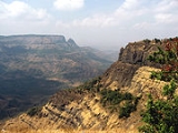
The Western Ghats, Western Ghauts or the Sahyādri is a mountain range along the western side of India
. It runs north to south along the western edge of the Deccan Plateau
, and separates the plateau from a narrow coastal plain along the Arabian Sea
. The Western Ghats block rainfall to the Deccan Plateau. The range starts near the border of Gujarat and Maharashtra
, south of the Tapti river
, and runs approximately 1600 km through the states of Maharashtra
, Goa
, Karnataka
, Tamil Nadu
and Kerala
ending at Kanyakumari
, at the southern tip of India.
These hills cover 160,000 km² and form the catchment area for complex riverine drainage system
s that drain almost 40% of India.
The average elevation is around 1200 metres (3,937 ft). The area is one of the world’s ten "Hottest biodiversity hotspot
s" and has over 5000 species of flowering plants, 139 mammal species, 508 bird species and 179 amphibian species, many undiscovered species lives in the Western Ghats. At least 325 globally threatened species occur in the Western Ghats.
. They are believed to have been formed during the break-up of the super continent of Gondwana
some 150 million years ago. Geophysicists
Barron and Harrison from the University of Miami
advocate the theory that the west coast of India came into being somewhere around 100 to 80 mya after it broke away from Madagascar. After the break-up, the western coast of India would have appeared as an abrupt cliff some 1,000 meters in height.
Soon after its detachment, the peninsular region of the Indian plate drifted over the Réunion hotspot
, a volcanic hotspot in the Earth's lithosphere near the present day location of Réunion
. A huge eruption here some 65 mya is thought to have laid down the Deccan Traps
, a vast bed of basalt lava that covers parts of central India. These volcanic upthrusts led to the formation of the northern third of the Western Ghats. These dome-shaped uplifts expose underlying 200 mya rocks observed in some parts such as the Nilgiri Hills.
Basalt
is the predominant rock found in the hills reaching a depth of . Other rock types found are charnockite
s, granite
gneiss, khondalites, leptynites, metamorphic gneiss
es with detached occurrences of crystalline limestone
, iron ore, dolerites and anorthosite
s. Residual laterite
and bauxite
ores are also found in the southern hills.
in the north, go south past Goa
, through Karnataka
and into Kerala
and Tamil Nadu
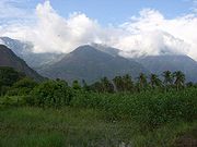
. The major hill range starting from the north is the Sahyadhri (the benevolent mountains) range. This range is home to many hill station
s like Matheran
, Lonavala-Khandala
, Mahabaleshwar
, Panchgani
, Amboli Ghat, Kudremukh
and Kodagu
. The range is called Sahyadri in northern Maharashtra
and Sahya Parvatam in Kerala. The Bili giri rangana Betta southeast of Mysore in Karnataka
, meet the Shevaroys (Servarayan range) and Tirumala range farther east, linking the Western Ghats to the Eastern Ghats
. In the south the range is known as the Nilagiri malai in Tamil Nadu
.
Smaller ranges, including the Cardamom Hills
and the Nilgiri Hills, are in northwestern Tamil Nadu
. The Nilgiri Hills are home to the hill station Ooty. In the southern part of the range in the Anaimalai Hills
, in western Tamil Nadu and Kerala. Ana Mudi 2695 metres (8,842 ft) in Kerala
the highest peak in Western Ghats. Chembra Peak
2100 metres (6,890 ft), Banasura Peak 2073 metres (6,801 ft), Vellarimala
2200 metres (7,218 ft) and Agasthya mala 1868 metres (6,129 ft) are also in Kerala
. Doddabetta is 2637 metres (8,652 ft). Mullayanagiri
is the highest peak in Karnataka 1950 metres (6,398 ft). The Western Ghats in Kerala is home to many tea
and coffee
plantation
s. The major gaps in the range are the Goa Gap
, between the Maharashtra and Karnataka sections, and the Palghat Gap on the Tamil Nadu/Kerala border between the Nilgiri Hills and the Anaimalai Hills.
The northern portion of the narrow coastal plain between the Western Ghats and the Arabian Sea is known as the Konkan Coast or simply Konkan
, the central portion is called Kanara
and the southern portion is called Malabar region or the Malabar Coast
. The foothill region east of the Ghats in Maharashtra
is known as Desh, while the eastern foothills of the central Karnataka state is known as Malenadu. The largest city within the mountains is the city of Pune
(Poona), in the Desh region on the eastern edge of the range. The Biligirirangan Hills
lies at the confluence
of the Western and Eastern Ghats
.
The mountains intercept the rain-bearing westerly monsoon
winds, and are consequently an area of high rainfall, particularly on their western side. The dense forests also contribute to the precipitation of the area by acting as a substrate for condensation of moist rising orographic winds from the sea, and releasing much of the moisture back into the air via transpiration
, allowing it to later condense and fall again as rain.
(2285 m, 26 ha) and the Berijam
in the Palni Hills
. The Pookode lake
of Wayanad in Kerala at Lakkadi is a beautiful scenic one with boating and garden arrangements. Most of the bigger lakes are situated in the state of Tamil Nadu. Two smaller lakes, the Devikulam (6.0 ha) and the Letchmi Elephant (2.0 ha) are in the Munnar
range.
The majority of streams draining the Western Ghats and joining the Rivers Krishna and Kaveri carry water during monsoon months only and have been dammed for hydroelectric and irrigation
purposes. The major reservoirs are: Lonavala and Walwahn in Maharashtra; V.V. Sagar, K.R. Sagar and Tungabhadra in the Malenadu area of Karnataka; Mettur, Upper Bhawani, Mukurti, Parson's Valley, Porthumund, Avalanche, Emarold, Pykara, Sandynulla and Glenmorgan in Tamil Nadu; and Kundallay and Maddupatty in the High Range of Kerala. Of these the Lonavla, Walwahn, Upper Bhawani, Mukurti, Parson's Valley, Porthumund, Avalanche, Emarold, Pykara, Sandynulla, Glenmorgan, Kundally and Madupatty are important for their commercial and sport fisheries for trout, mahseer and common carp.
 The Western Ghats form one of the three watershed
s of India, feeding the perennial rivers of India. Important rivers include the Godavari
, Krishna
, and Kaveri
. These rivers flow to the east and drain out into the Bay of Bengal
. The west flowing rivers, that drain into the Arabian Sea
, are fast-moving, owing to the short distance travelled and steeper gradient. Important rivers include the Mandovi and Zuari
. Many of these rivers feed the backwaters of Kerala and Maharashtra. Rivers that flow eastwards of the Ghats drain into the Bay of Bengal
. These are comparatively slower moving and eventually merge into larger rivers such as the Kaveri and Krishna. The larger tributaries include the Tunga River
, Bhadra river
, Bhima River
, Malaprabha River
, Ghataprabha River
, Hemavathi river, Kabini River
. In addition there are several smaller rivers such as the Chittar River
, Manimuthar River
, Kallayi River
, Kundali River
, Pachaiyar River
, Pennar River, Periyar
and the Kallayi River
.
Fast running rivers and steep slopes have provided sites for many large hydro-electric projects. There are about 50 major dams along the length of the Western Ghats with the earliest project up in 1900 near Khopoli
in Maharashtra. Most notable of these projects are the Koyna Hydroelectric Project
in Maharashtra, the Parambikulam Dam
in Kerala, and the Linganmakki Dam in Karnataka. The reservoir behind the Koyna Dam, the Shivajisagar Lake
, has a length of and depth of . It is the largest hydroelectric project in Maharashtra, generating 1,920 MW of electric power.
Another major Hydro Electric project is Idukki dam in Kerala. This dam is one of the biggest in Asia and generates around 70% of power for Kerala state. Mullai Periyar dam near Thekkady is one of the oldest in the world and a major tourist attractions in Kerala. Water from this dam is drawn to the vast coastal plain of Tamil Nadu, forming a delta and making it rich in vegetation.
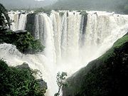
During the monsoon season, numerous streams fed by incessant rain drain off the mountain sides leading to numerous and often spectacular waterfalls. Among the most well known is the Jog Falls
, Kunchikal Falls
, Sivasamudram Falls, and Unchalli Falls. The Jog Falls is the highest natural plunge waterfall in South Asia and is listed among the 1001 natural wonders of the world. Talakaveri
wildlife sanctuary is a critical watershed and the source of the river Kaveri. This region has dense evergreen and semi-evergreen vegetation, with shola-grassland in areas of higher elevation. The steep terrain of the area has resulted in scenic waterfalls along its many mountain streams. Sharavathi and Someshvara Wildlife sanctuaries in Shimoga district
are the source of the Tungabhadra River system.The Netravathi river has also its origin at western ghats of India flowing westwards to join Arabian sea
at Mangalore
.
 Climate in the Western Ghats varies with altitudinal gradation and distance from the equator. The climate is humid and tropical in the lower reaches tempered by the proximity to the sea. Elevations of and above in the north and and above in the south have a more temperate climate. Average annual temperature here are around 15 °C (60 °F). In some parts frost is common, and temperatures touch the freezing point during the winter months. Mean temperature range from 20 °C (68 °F) in the south to 24 °C (75 °F) in the north. It has also been observed that the coldest periods in the south western ghats coincide with the wettest.
During the monsoon season
between June and September, the unbroken Western Ghats chain acts as a barrier to the moisture laden clouds. The heavy, eastward-moving rain-bearing clouds are forced to rise and in the process deposit most of their rain on the windward side. Rainfall in this region averages 3,000–4,000 mm (120–160 in) with localised extremes touching 9,000 mm (350 in). The eastern region of the Western Ghats which lie in the rain shadow
, receive far less rainfall averaging about 1,000 mm (40 in) bringing the average rainfall figure to 2,500 mm (150 in). Data from rainfall figures reveal that there is no relationship between the total amount of rain received and the spread of the area. Some areas to the north in Maharashtra while receiving heavier rainfall are followed by long dry spells, while regions closer to the equator receiving less annual rainfall, have rain spells lasting almost the entire year.

 The Western Ghats are home to four tropical and subtropical moist broadleaf forest ecoregions – the North Western Ghats moist deciduous forests
, North Western Ghats montane rain forests
, South Western Ghats moist deciduous forests
, and South Western Ghats montane rain forests
.
The northern portion of the range is generally drier than the southern portion, and at lower elevations makes up the North Western Ghats moist deciduous forests ecoregion, with mostly deciduous forests made up predominantly of teak
. Above 1,000 meters elevation are the cooler and wetter North Western Ghats montane rain forests
, whose evergreen forests are characterized by trees of family Lauraceae
.
The evergreen Wayanad forests of Kerala mark the transition zone between the northern and southern ecoregions of the Western Ghats. The southern ecoregions are generally wetter and more species-rich. At lower elevations are the South Western Ghats moist deciduous forests
, with Cullenia
the characteristic tree genus, accompanied by teak, dipterocarps, and other trees. The moist forests transition to the drier South Deccan Plateau dry deciduous forests
, which lie in its rain shadow to the east.
Above 1,000 meters are the South Western Ghats montane rain forests
, also cooler and wetter than the surrounding lowland forests, and dominated by evergreen trees, although some montane grasslands and stunted forests can be found at the highest elevations. The South Western Ghats montane rain forests are the most species-rich ecoregion in peninsular India; eighty percent of the flowering plant
species of the entire Western Ghats range are found in this ecoregion.
. Its inaccessibility made it difficult for people from the plains
to cultivate the land and build settlements. After the arrival of the British in the area, large swathes of territory were cleared for agricultural plantations and timber. The forest in the Western Ghats has been severely fragmented due to human activities, especially clear felling for tea, coffee, and teak plantations during 1860 to 1950. Species that are rare, endemic and habitat specialists are more adversely affected and tend to be lost faster than other species. Complex and species rich habitats like the tropical rainforest are much more adversely affected than other habitats.
The area is ecologically sensitive to development and was declared an ecological hotspot in 1988 through the efforts of ecologist Norman Myers
. Though this area covers barely five percent of India's land, 27% of all species of higher plants in India (4,000 of 15,000 species) are found here. Almost 1,800 of these are endemic
to the region. The range is home to at least 84 amphibian species, 16 bird species, seven mammals, and 1,600 flowering plants which are not found elsewhere in the world.
The Government of India
established many protected areas
including 2 biosphere reserve
s, 13 National parks
to restrict human access, several wildlife sanctuaries
to protect specific endangered species and many Reserve Forest
s, which are all managed by the forest departments of their respective state to preserve some of the ecoregions still undeveloped. Many National Parks were initially Wildlife Sanctuaries. The Nilgiri Biosphere Reserve
comprising 5500 km² of the evergreen forests of Nagarahole, deciduous forests of Bandipur National Park
and Nugu in Karnataka and adjoining regions of Wayanad (വയനാട്) and Mudumalai National Park
in the states of Kerala
and Tamil Nadu
forms the largest contiguous protected area in the Western Ghats. The Western Ghats in Kerala is home to numerous serene hill stations like Munnar
(മുന്നാര്), Ponmudi
(പൊന്മുടി) and Waynad. The Silent Valley National Park
(സൈലന്റ് വാലി) in Kerala is among the last tracts of virgin tropical evergreen forest in India.
Regarding the Western Ghats, in November 2009, Minister of Environment and Forests
, Jairam Ramesh
said,
In a letter dated June 20, 2009, Mr. Ramesh said,
The Expert Appraisal Committee appointed by Union Government also said that the project should not be taken up.
 In 2006, India applied to the UNESCO
MAB for the Western Ghats to be listed as a protected World Heritage Site. This will be composed of 7 adjoining areas:
species including at least 325 globally threatened species
. Many are endemic
species, especially in the amphibian and reptilian classes
.
of history and commerce.
India
India , officially the Republic of India , is a country in South Asia. It is the seventh-largest country by geographical area, the second-most populous country with over 1.2 billion people, and the most populous democracy in the world...
. It runs north to south along the western edge of the Deccan Plateau
Deccan Plateau
The Deccan Plateau is a large plateau in India, making up the majority of the southern part of the country. It rises a hundred meters high in the north, rising further to more than a kilometers high in the south, forming a raised triangle nested within the familiar downward-pointing triangle of...
, and separates the plateau from a narrow coastal plain along the Arabian Sea
Arabian Sea
The Arabian Sea is a region of the Indian Ocean bounded on the east by India, on the north by Pakistan and Iran, on the west by the Arabian Peninsula, on the south, approximately, by a line between Cape Guardafui in northeastern Somalia and Kanyakumari in India...
. The Western Ghats block rainfall to the Deccan Plateau. The range starts near the border of Gujarat and Maharashtra
Maharashtra
Maharashtra is a state located in India. It is the second most populous after Uttar Pradesh and third largest state by area in India...
, south of the Tapti river
Tapti River
The Tapi River ancient original name Tapi River , is a river in central India. It is one of the major rivers of peninsular India with a length of around 724 km...
, and runs approximately 1600 km through the states of Maharashtra
Maharashtra
Maharashtra is a state located in India. It is the second most populous after Uttar Pradesh and third largest state by area in India...
, Goa
Goa
Goa , a former Portuguese colony, is India's smallest state by area and the fourth smallest by population. Located in South West India in the region known as the Konkan, it is bounded by the state of Maharashtra to the north, and by Karnataka to the east and south, while the Arabian Sea forms its...
, Karnataka
Karnataka
Karnataka , the land of the Kannadigas, is a state in South West India. It was created on 1 November 1956, with the passing of the States Reorganisation Act and this day is annually celebrated as Karnataka Rajyotsava...
, Tamil Nadu
Tamil Nadu
Tamil Nadu is one of the 28 states of India. Its capital and largest city is Chennai. Tamil Nadu lies in the southernmost part of the Indian Peninsula and is bordered by the union territory of Pondicherry, and the states of Kerala, Karnataka, and Andhra Pradesh...
and Kerala
Kerala
or Keralam is an Indian state located on the Malabar coast of south-west India. It was created on 1 November 1956 by the States Reorganisation Act by combining various Malayalam speaking regions....
ending at Kanyakumari
Kanyakumari
Kanyakumari is a town in the state of Tamil Nadu in India. It is also sometimes referred to as Cape Comorin. Located at the southernmost tip of the Indian Peninsula, it is the geographical end of the Indian mainland. The district in Tamil Nadu where the town is located is called Kanyakumari...
, at the southern tip of India.
These hills cover 160,000 km² and form the catchment area for complex riverine drainage system
Drainage system (Geomorphology)
In geomorphology, a drainage system is the pattern formed by the streams, rivers, and lakes in a particular drainage basin. They are governed by the topography of the land, whether a particular region is dominated by hard or soft rocks, and the gradient of the land. Geomorphologists and...
s that drain almost 40% of India.
The average elevation is around 1200 metres (3,937 ft). The area is one of the world’s ten "Hottest biodiversity hotspot
Biodiversity hotspot
A biodiversity hotspot is a biogeographic region with a significant reservoir of biodiversity that is under threat from humans.The concept of biodiversity hotspots was originated by Norman Myers in two articles in “The Environmentalist” , revised after thorough analysis by Myers and others in...
s" and has over 5000 species of flowering plants, 139 mammal species, 508 bird species and 179 amphibian species, many undiscovered species lives in the Western Ghats. At least 325 globally threatened species occur in the Western Ghats.
Geology
The Western Ghats are not true mountains, but are the faulted edge of the Deccan PlateauDeccan Plateau
The Deccan Plateau is a large plateau in India, making up the majority of the southern part of the country. It rises a hundred meters high in the north, rising further to more than a kilometers high in the south, forming a raised triangle nested within the familiar downward-pointing triangle of...
. They are believed to have been formed during the break-up of the super continent of Gondwana
Gondwana
In paleogeography, Gondwana , originally Gondwanaland, was the southernmost of two supercontinents that later became parts of the Pangaea supercontinent. It existed from approximately 510 to 180 million years ago . Gondwana is believed to have sutured between ca. 570 and 510 Mya,...
some 150 million years ago. Geophysicists
Geophysics
Geophysics is the physics of the Earth and its environment in space; also the study of the Earth using quantitative physical methods. The term geophysics sometimes refers only to the geological applications: Earth's shape; its gravitational and magnetic fields; its internal structure and...
Barron and Harrison from the University of Miami
University of Miami
The University of Miami is a private, non-sectarian university founded in 1925 with its main campus in Coral Gables, Florida, a medical campus in Miami city proper at Civic Center, and an oceanographic research facility on Virginia Key., the university currently enrolls 15,629 students in 12...
advocate the theory that the west coast of India came into being somewhere around 100 to 80 mya after it broke away from Madagascar. After the break-up, the western coast of India would have appeared as an abrupt cliff some 1,000 meters in height.
Soon after its detachment, the peninsular region of the Indian plate drifted over the Réunion hotspot
Réunion hotspot
The Réunion hotspot is a volcanic hotspot which currently lies under the Island of Réunion in the Indian Ocean. The Chagos-Laccadive Ridge and the southern part of the Mascarene Plateau are volcanic traces of the Réunion hotspot....
, a volcanic hotspot in the Earth's lithosphere near the present day location of Réunion
Réunion
Réunion is a French island with a population of about 800,000 located in the Indian Ocean, east of Madagascar, about south west of Mauritius, the nearest island.Administratively, Réunion is one of the overseas departments of France...
. A huge eruption here some 65 mya is thought to have laid down the Deccan Traps
Deccan Traps
The Deccan Traps are a large igneous province located on the Deccan Plateau of west-central India and one of the largest volcanic features on Earth. They consist of multiple layers of solidified flood basalt that together are more than thick and cover an area of and a volume of...
, a vast bed of basalt lava that covers parts of central India. These volcanic upthrusts led to the formation of the northern third of the Western Ghats. These dome-shaped uplifts expose underlying 200 mya rocks observed in some parts such as the Nilgiri Hills.
Basalt
Basalt
Basalt is a common extrusive volcanic rock. It is usually grey to black and fine-grained due to rapid cooling of lava at the surface of a planet. It may be porphyritic containing larger crystals in a fine matrix, or vesicular, or frothy scoria. Unweathered basalt is black or grey...
is the predominant rock found in the hills reaching a depth of . Other rock types found are charnockite
Charnockite
Charnockite is applied to any orthopyroxene-bearing granite, composed mainly of quartz, perthite or antiperthite and orthopyroxene , as an end-member of the charnockite series.-Charnockite series:...
s, granite
Granite
Granite is a common and widely occurring type of intrusive, felsic, igneous rock. Granite usually has a medium- to coarse-grained texture. Occasionally some individual crystals are larger than the groundmass, in which case the texture is known as porphyritic. A granitic rock with a porphyritic...
gneiss, khondalites, leptynites, metamorphic gneiss
Gneiss
Gneiss is a common and widely distributed type of rock formed by high-grade regional metamorphic processes from pre-existing formations that were originally either igneous or sedimentary rocks.-Etymology:...
es with detached occurrences of crystalline limestone
Limestone
Limestone is a sedimentary rock composed largely of the minerals calcite and aragonite, which are different crystal forms of calcium carbonate . Many limestones are composed from skeletal fragments of marine organisms such as coral or foraminifera....
, iron ore, dolerites and anorthosite
Anorthosite
Anorthosite is a phaneritic, intrusive igneous rock characterized by a predominance of plagioclase feldspar , and a minimal mafic component...
s. Residual laterite
Laterite
Laterites are soil types rich in iron and aluminium, formed in hot and wet tropical areas. Nearly all laterites are rusty-red because of iron oxides. They develop by intensive and long-lasting weathering of the underlying parent rock...
and bauxite
Bauxite
Bauxite is an aluminium ore and is the main source of aluminium. This form of rock consists mostly of the minerals gibbsite Al3, boehmite γ-AlO, and diaspore α-AlO, in a mixture with the two iron oxides goethite and hematite, the clay mineral kaolinite, and small amounts of anatase TiO2...
ores are also found in the southern hills.
Mountains
The Western Ghats extend from the Satpura RangeSatpura Range
The Satpura Range is a range of hills in central India. The range rises in eastern Gujarat state near the Arabian Sea coast, running east through Maharashtra and Madhya Pradesh to Chhattisgarh. The range parallels the Vindhya Range to the north, and these two east-west ranges divide the...
in the north, go south past Goa
Goa
Goa , a former Portuguese colony, is India's smallest state by area and the fourth smallest by population. Located in South West India in the region known as the Konkan, it is bounded by the state of Maharashtra to the north, and by Karnataka to the east and south, while the Arabian Sea forms its...
, through Karnataka
Karnataka
Karnataka , the land of the Kannadigas, is a state in South West India. It was created on 1 November 1956, with the passing of the States Reorganisation Act and this day is annually celebrated as Karnataka Rajyotsava...
and into Kerala
Kerala
or Keralam is an Indian state located on the Malabar coast of south-west India. It was created on 1 November 1956 by the States Reorganisation Act by combining various Malayalam speaking regions....
and Tamil Nadu
Tamil Nadu
Tamil Nadu is one of the 28 states of India. Its capital and largest city is Chennai. Tamil Nadu lies in the southernmost part of the Indian Peninsula and is bordered by the union territory of Pondicherry, and the states of Kerala, Karnataka, and Andhra Pradesh...
. The major hill range starting from the north is the Sahyadhri (the benevolent mountains) range. This range is home to many hill station
Hill station
A hill station is a town located at a higher elevation than the nearby plain or valley. The term was used mostly in colonial Asia , but also in Africa , for towns founded by European colonial rulers as refuges from the summer heat, up where temperatures are cooler...
s like Matheran
Matheran
- Getting to Matheran :Matheran is located about 100 km from Mumbai, 120 km from Pune. and 320 km from Surat. It lies on the busy Mumbai-Pune rail link and the nearest train station is at Neral, approximately 11 km from Matheran. From Neral, one can either rent a taxi to the...
, Lonavala-Khandala
Khandala
Khandala is a hill station in the Western Ghats in the state of Maharashtra, India, about three kilometres from Lonavala and seven kilometers from Karjat....
, Mahabaleshwar
Mahabaleshwar
Mahabaleshwar is a city and a municipal council in Satara district in the Indian state of Maharashtra. It is a hill station located in the Western Ghats range. With one of the few evergreen forests of the world, it served as the summer capital of Bombay province during the British Raj.-Geography...
, Panchgani
Panchgani
Pānchgani is a town and municipal council in Sātārā district in Mahārāshtra, India .-History:Scenic Panchgani was discovered by the British during the British Raj as a summer resort, and a superintendent named John Chesson was placed in charge of the hill station in the 1860s...
, Amboli Ghat, Kudremukh
Kudremukh
Kudremukh also spelled Kuduremukha is a mountain range in Chikkamagaluru district, in Karnataka, India. It is also the name of a small hill station town situated near the mountain, about 48 kilometers from Karkala and about 20 kilometers from Kalasa...
and Kodagu
Kodagu
Kodagu , also known by its anglicised former name of Coorg, is an administrative district in Karnataka, India. It occupies an area of in the Western Ghats of southwestern Karnataka. As of 2001, the population was 548,561, 13.74% of which resided in the district's urban centres, making it the least...
. The range is called Sahyadri in northern Maharashtra
Maharashtra
Maharashtra is a state located in India. It is the second most populous after Uttar Pradesh and third largest state by area in India...
and Sahya Parvatam in Kerala. The Bili giri rangana Betta southeast of Mysore in Karnataka
Karnataka
Karnataka , the land of the Kannadigas, is a state in South West India. It was created on 1 November 1956, with the passing of the States Reorganisation Act and this day is annually celebrated as Karnataka Rajyotsava...
, meet the Shevaroys (Servarayan range) and Tirumala range farther east, linking the Western Ghats to the Eastern Ghats
Eastern Ghats
The Eastern Ghats or Eastern Ghauts are a discontinuous range of mountains along India's eastern coast. The Eastern Ghats run from West Bengal state in the north, through Orissa and Andhra Pradesh to Tamil Nadu in the south passing some parts of Karnataka. They are eroded and cut through by the...
. In the south the range is known as the Nilagiri malai in Tamil Nadu
Tamil Nadu
Tamil Nadu is one of the 28 states of India. Its capital and largest city is Chennai. Tamil Nadu lies in the southernmost part of the Indian Peninsula and is bordered by the union territory of Pondicherry, and the states of Kerala, Karnataka, and Andhra Pradesh...
.
Smaller ranges, including the Cardamom Hills
Cardamom Hills
Not to be confused with Cardamom Mountains in Cambodia. For other uses, see Cardamom The Cardamom Hills are part of the southern Western Ghats located in southeast Kerala and southwest Tamil Nadu in South India. Their name comes from the cardamom spice grown in much of the hill's cool elevation,...
and the Nilgiri Hills, are in northwestern Tamil Nadu
Tamil Nadu
Tamil Nadu is one of the 28 states of India. Its capital and largest city is Chennai. Tamil Nadu lies in the southernmost part of the Indian Peninsula and is bordered by the union territory of Pondicherry, and the states of Kerala, Karnataka, and Andhra Pradesh...
. The Nilgiri Hills are home to the hill station Ooty. In the southern part of the range in the Anaimalai Hills
Anaimalai Hills
The Anaimalai Hills is a range of mountains in the Western Ghats in Tamil Nadu and Kerala states of South India. The name "Anaimalai" derives from the Tamil word 'Ana' meaning elephant and 'Mala' meaning hill, thus Elephant Hill. The highest peak of the Anaimalai Hills is Anamudi, , located in the...
, in western Tamil Nadu and Kerala. Ana Mudi 2695 metres (8,842 ft) in Kerala
Kerala
or Keralam is an Indian state located on the Malabar coast of south-west India. It was created on 1 November 1956 by the States Reorganisation Act by combining various Malayalam speaking regions....
the highest peak in Western Ghats. Chembra Peak
Chembra Peak
Chembra Peak is the highest peak in Wayanad, at above sea level. Chembra is located near the town of Meppady and is 8 km south of Kalpetta. It is part of the Wayanad hill ranges in Western Ghats, adjoining the Nilgiri Hills in Tamilnadu and Vellarimala in Kozhikode district in Kerala.Chembra...
2100 metres (6,890 ft), Banasura Peak 2073 metres (6,801 ft), Vellarimala
Vellarimala
Vellarimala is a mountain range in Thiruvambady Panchayat on Kozhikode district of Kerala, India.- Description :Vellarimala forms a part of a high hill range of what is otherwise known as Camel's Hump Mountains, a part of the Western Ghats...
2200 metres (7,218 ft) and Agasthya mala 1868 metres (6,129 ft) are also in Kerala
Kerala
or Keralam is an Indian state located on the Malabar coast of south-west India. It was created on 1 November 1956 by the States Reorganisation Act by combining various Malayalam speaking regions....
. Doddabetta is 2637 metres (8,652 ft). Mullayanagiri
Mullayanagiri
Mullayanagiri , is the highest peak in Karnataka, India. Mullayanagiri is located at in the Baba Budan Giri Range of the Western Ghats...
is the highest peak in Karnataka 1950 metres (6,398 ft). The Western Ghats in Kerala is home to many tea
Tea
Tea is an aromatic beverage prepared by adding cured leaves of the Camellia sinensis plant to hot water. The term also refers to the plant itself. After water, tea is the most widely consumed beverage in the world...
and coffee
Coffee
Coffee is a brewed beverage with a dark,init brooo acidic flavor prepared from the roasted seeds of the coffee plant, colloquially called coffee beans. The beans are found in coffee cherries, which grow on trees cultivated in over 70 countries, primarily in equatorial Latin America, Southeast Asia,...
plantation
Plantation
A plantation is a long artificially established forest, farm or estate, where crops are grown for sale, often in distant markets rather than for local on-site consumption...
s. The major gaps in the range are the Goa Gap
Goa Gap
The Goa Gap is one of the major passes in the Western Ghats, between the Maharashtra and Karnataka sections....
, between the Maharashtra and Karnataka sections, and the Palghat Gap on the Tamil Nadu/Kerala border between the Nilgiri Hills and the Anaimalai Hills.
The northern portion of the narrow coastal plain between the Western Ghats and the Arabian Sea is known as the Konkan Coast or simply Konkan
Konkan
The Konkan also called the Konkan Coast or Karavali is a rugged section of the western coastline of India from Raigad to Mangalore...
, the central portion is called Kanara
Kanara
The Kanara or Canara region comprises three coastal districts of Karnataka, namely Dakshina Kannada, Udupi and Uttara Kannada and Kasaragod district of Kerala in southwestern India. Kanara forms the southern part of the Konkan coast...
and the southern portion is called Malabar region or the Malabar Coast
Malabar Coast
The Malabar Coast is a long and narrow coastline on the south-western shore line of the mainland Indian subcontinent. Geographically, it comprises the wettest regions of southern India, as the Western Ghats intercept the moisture-laden monsoon rains, especially on their westward-facing mountain...
. The foothill region east of the Ghats in Maharashtra
Maharashtra
Maharashtra is a state located in India. It is the second most populous after Uttar Pradesh and third largest state by area in India...
is known as Desh, while the eastern foothills of the central Karnataka state is known as Malenadu. The largest city within the mountains is the city of Pune
Pune
Pune , is the eighth largest metropolis in India, the second largest in the state of Maharashtra after Mumbai, and the largest city in the Western Ghats. Once the centre of power of the Maratha Empire, it is situated 560 metres above sea level on the Deccan plateau at the confluence of the Mula ...
(Poona), in the Desh region on the eastern edge of the range. The Biligirirangan Hills
Biligirirangan Hills
The Biligiriranga Hills, commonly called B R Hills, is a hill range situated in south-eastern Karnataka, at its border with Tamil Nadu in South India. The area is called Biligiriranga Swamy Temple Wildlife Sanctuary or simply BRT Wildlife Sanctuary. It is a protected reserve under the Wildlife...
lies at the confluence
Confluence
Confluence, in geography, describes the meeting of two or more bodies of water.Confluence may also refer to:* Confluence , a property of term rewriting systems...
of the Western and Eastern Ghats
Eastern Ghats
The Eastern Ghats or Eastern Ghauts are a discontinuous range of mountains along India's eastern coast. The Eastern Ghats run from West Bengal state in the north, through Orissa and Andhra Pradesh to Tamil Nadu in the south passing some parts of Karnataka. They are eroded and cut through by the...
.
The mountains intercept the rain-bearing westerly monsoon
Monsoon
Monsoon is traditionally defined as a seasonal reversing wind accompanied by corresponding changes in precipitation, but is now used to describe seasonal changes in atmospheric circulation and precipitation associated with the asymmetric heating of land and sea...
winds, and are consequently an area of high rainfall, particularly on their western side. The dense forests also contribute to the precipitation of the area by acting as a substrate for condensation of moist rising orographic winds from the sea, and releasing much of the moisture back into the air via transpiration
Transpiration
Transpiration is a process similar to evaporation. It is a part of the water cycle, and it is the loss of water vapor from parts of plants , especially in leaves but also in stems, flowers and roots. Leaf surfaces are dotted with openings which are collectively called stomata, and in most plants...
, allowing it to later condense and fall again as rain.
Peaks
Following is a list of 15 highest peaks of the Western Ghats:| Rank | Name | Elevation (m) | Location |
|---|---|---|---|
| 01. | Anamudi Anamudi Anamudi is located in the Indian state Kerala. It is the highest peak in the Western Ghats and South India, at an elevation of , and a topographic prominence of... |
2695 | Eravikulam National Park Eravikulam National Park Eravikulam National Park is a 97 km² national park located along the Western Ghats in the Idukki district of Kerala in India, between 10º05'N - 10º20'N latitude and 77º0'E - 77º10'E longitude... , Kerala Kerala or Keralam is an Indian state located on the Malabar coast of south-west India. It was created on 1 November 1956 by the States Reorganisation Act by combining various Malayalam speaking regions.... |
| 02. | Doddabetta Doddabetta Doddabetta is the highest mountain in the Nilgiri Hills, at 2637 metre . There is a reserved forest area around the peak. It is 9 km from Ooty,on Ooty-Kotagiri Road in the Nilgiris District of Tamil Nadu, South India... |
2637 | Ooty, Tamil Nadu Tamil Nadu Tamil Nadu is one of the 28 states of India. Its capital and largest city is Chennai. Tamil Nadu lies in the southernmost part of the Indian Peninsula and is bordered by the union territory of Pondicherry, and the states of Kerala, Karnataka, and Andhra Pradesh... |
| 03. | Vavul Mala | 2339 | Pulloorampara Pulloorampara Pulloorampara is a village which is situated near by Thiruvambady town in Calicut district Kerala.It is about 42 km distant from Calicut town and is widespread in two panchayats Thiruvambady and Kodencheri. The river Iruvanjippuzha flows through Pulloorampara. The two main junctions in... , Kerala |
| 04. | Elivai Malai | 2088 | Palakkad Palakkad Palakkad , formerly known as Palghat, is a municipality and a town in the state of Kerala in southern India, spread over an area of 26.60 km2.The city is situated about north of state capital Thiruvananthapuram. It is the administrative headquarters of Palakkad District... , Kerala |
| 05. | Mullayanagiri Mullayanagiri Mullayanagiri , is the highest peak in Karnataka, India. Mullayanagiri is located at in the Baba Budan Giri Range of the Western Ghats... |
1930 | Chikmagalur, Karnataka Karnataka Karnataka , the land of the Kannadigas, is a state in South West India. It was created on 1 November 1956, with the passing of the States Reorganisation Act and this day is annually celebrated as Karnataka Rajyotsava... |
| 06. | Kudremukh Kudremukh Kudremukh also spelled Kuduremukha is a mountain range in Chikkamagaluru district, in Karnataka, India. It is also the name of a small hill station town situated near the mountain, about 48 kilometers from Karkala and about 20 kilometers from Kalasa... |
1894 | Chikkamagaluru district, Karnataka |
| 07. | Tadiandamol Tadiandamol Tadiandamol is the highest mountain of Kodagu district, Karnataka, India. It is located on the Western Ghats range, and reaches an elevation of 1,748 m. It is a place of interest for trekkers and naturalists. The mountain has patches of shola forests in the valleys.The Nalaknad palace at the... |
1748 | Kodagu district, Karnataka |
| 08. | Pushpagiri Pushpagiri Pushpagiri, at 1,712 meters, is the highest peak in Pushpagiri Wildlife Sanctuary in the Western Ghats of Karnataka. It is located in the Somwarpet Taluk, 20 km from Somwarpet Town northern part of Kodagu district.-Pushpagiri Mountains:... |
1712 | Pushpagiri Wildlife Sanctuary Pushpagiri Wildlife Sanctuary Pushpagiri Wildlife Sanctuary is one of 21 Wildlife Sanctuaries of India's Karnataka state.This sanctuary is located in Somwarpet taluk of Kodagu district and has some attractive scenery. It is home to rare and endangered birdlife and is designated as one of the important bird areas of the world.... , Karnataka |
| 09. | Kalsubai Kalsubai Kalsubai Peak of the Sahyadris in Akole Taluka, of Ahmednagar district of Maharashtra.To reach the summit there are various trekking routes and animal tracks. The main route starts from the village of Bari which is about six km from Bhandardara. To reach Bari, one has to travel to Igatpuri on the... |
1646 | Ahmednagar district Ahmednagar district Ahmednagar district is the largest district of Maharashtra state in western India. The historical Ahmednagar city is the headquarters of the district. Ahmednagar was the seat of the Ahmednagar Sultanate of late medieval period . This district is also known for the towns of Shirdi associated with... , Maharashtra Maharashtra Maharashtra is a state located in India. It is the second most populous after Uttar Pradesh and third largest state by area in India... |
| 10. | Salher Salher Salher is a place located near Waghamba in Nasik district of Maharashtra, India. It is the site of the highest fort in the Sahyadri mountains and the second highest peak at after Kalsubai in Maharashtra.-History:... |
1567 | Nasik district, Maharashtra |
| 11. | Mahabaleshwar Mahabaleshwar Mahabaleshwar is a city and a municipal council in Satara district in the Indian state of Maharashtra. It is a hill station located in the Western Ghats range. With one of the few evergreen forests of the world, it served as the summer capital of Bombay province during the British Raj.-Geography... |
1438 | Mahabaleshwar, Satara district Satara district Satara District is a district of Maharashtra state in western India with an area of 10,480 km² and a population of 2,808,994 of which 14.17% were urban . Satara is the capital of the district and other major towns include Wai, Karad, Koregaon, Koyananagar, Rahimatpur, Phaltan, Mahabaleshwar... , Maharashtra |
| 12. | Torna Fort Torna Fort Torna Fort or Prachandagad is a large fort located in Pune district in the state of Maharashtra, India. It is historically significant because it is the first fort captured by Shivaji in 1643, forming the nucleus of the Maratha empire. The hill has an elevation of 1405 mts. above sea level, making... |
1405 | Pune district Pune District Pune District is situated in Maharashtra state of India. Pune city is the district headquarters. In the last census on 2001, the total population of the district was 7,232,555, making it the fourth most populous district in India . Urban population comprises 58.08% of the total population... , Maharashtra |
| 13. | Purandar fort Purandar fort Purandar fort पुरंदर किल्ला figures repeatedly in the rising of Shivaji against the Bijapur kingdom and the Mughals. Purandhar fort stands 4,472 ft. above the sea in the Western Ghats, 20 miles southeast of Pune. It actually consists of two forts - Purandar and Vajragad... |
1387 | Pune district, Maharashtra |
| 14. | Rajgad Rajgad Rajgad , literally meaning King of forts, one of the forts of Maharashtra state in India. Situated in the Pune district, the fort is approximately 1326 meters above sea level.... |
1326 | Pune district, Maharashtra |
| 15. | Sinhagad Sinhagad Sinhagad, Sinhgarh, or Sinhgad , is a fortress located roughly 30 kilometres southwest of the city of Pune, India. Previously called Kondhana , the fort has been the site of many important battles, most notably the battle of Sinhagad in 1670... |
1312 | Pune Pune Pune , is the eighth largest metropolis in India, the second largest in the state of Maharashtra after Mumbai, and the largest city in the Western Ghats. Once the centre of power of the Maratha Empire, it is situated 560 metres above sea level on the Deccan plateau at the confluence of the Mula ... , Maharashtra |
Lakes and reservoirs
The Western Ghats have several manmade lakes and reservoirs. The well known lakes are the Ooty (2500 m altitude, 34.0 ha) in Nilgiris, and the KodaikanalKodaikanal Lake
Kodaikanal Lake, also known as Kodai Lake is a manmade lake located in the Kodaikanal city in Dindigul district in Tamil Nadu, India. Sir Vere Hentry Levinge, the then Collector of Madurai, was instrumental in creating the lake in 1863, amidst the Kodaikanal town which was developed by the British...
(2285 m, 26 ha) and the Berijam
Berijam Lake
Berijam Lake is a reservoir near Kodaikanal town in Dindigul district of Tamil Nadu, South India. It is at the old site of "Fort Hamilton", in the upper Palani hills....
in the Palni Hills
Palni Hills
The Palni Hills are a mountain range in Tamil Nadu state of South India. The Palni Hills are an eastward extension of the Western Ghats ranges, which run parallel to the west coast of India. The Palni Hills adjoin the high Anamalai range on the west, and extend east into the plains of Tamil Nadu,...
. The Pookode lake
Pookode Lake
Pookode Lake is a scenic lake in Wayanad district, Kerala, South India. The lake is surrounded by forests, and boating is allowed. Recent commercial modernisations have removed some of its wilderness charms....
of Wayanad in Kerala at Lakkadi is a beautiful scenic one with boating and garden arrangements. Most of the bigger lakes are situated in the state of Tamil Nadu. Two smaller lakes, the Devikulam (6.0 ha) and the Letchmi Elephant (2.0 ha) are in the Munnar
Munnar
Munnar is one of the most popular hill station in Kerala and in southern India. Munnar is located on the Western Ghats, situated in the Idukki district....
range.
The majority of streams draining the Western Ghats and joining the Rivers Krishna and Kaveri carry water during monsoon months only and have been dammed for hydroelectric and irrigation
Irrigation
Irrigation may be defined as the science of artificial application of water to the land or soil. It is used to assist in the growing of agricultural crops, maintenance of landscapes, and revegetation of disturbed soils in dry areas and during periods of inadequate rainfall...
purposes. The major reservoirs are: Lonavala and Walwahn in Maharashtra; V.V. Sagar, K.R. Sagar and Tungabhadra in the Malenadu area of Karnataka; Mettur, Upper Bhawani, Mukurti, Parson's Valley, Porthumund, Avalanche, Emarold, Pykara, Sandynulla and Glenmorgan in Tamil Nadu; and Kundallay and Maddupatty in the High Range of Kerala. Of these the Lonavla, Walwahn, Upper Bhawani, Mukurti, Parson's Valley, Porthumund, Avalanche, Emarold, Pykara, Sandynulla, Glenmorgan, Kundally and Madupatty are important for their commercial and sport fisheries for trout, mahseer and common carp.
Rivers
Drainage basin
A drainage basin is an extent or an area of land where surface water from rain and melting snow or ice converges to a single point, usually the exit of the basin, where the waters join another waterbody, such as a river, lake, reservoir, estuary, wetland, sea, or ocean...
s of India, feeding the perennial rivers of India. Important rivers include the Godavari
Godavari River
The Godavari is a river that runs from western to southern India and is considered to be one of the big river basins in India. With a length of 1465 km, it is the second longest river in India , that runs within the country and also the longest river in South India...
, Krishna
Krishna River
The Krishna River , is one of the longest rivers in central-southern India, about . It is also referred to as Krishnaveni in its original nomenclature...
, and Kaveri
Kaveri River
The Kaveri , also spelled Cauvery in English, is a large Indian river. The origin of the river is traditionally placed at Talakaveri, Kodagu in the Western Ghats in Karnataka, flows generally south and east through Karnataka and Tamil Nadu and across the southern Deccan plateau through the...
. These rivers flow to the east and drain out into the Bay of Bengal
Bay of Bengal
The Bay of Bengal , the largest bay in the world, forms the northeastern part of the Indian Ocean. It resembles a triangle in shape, and is bordered mostly by the Eastern Coast of India, southern coast of Bangladesh and Sri Lanka to the west and Burma and the Andaman and Nicobar Islands to the...
. The west flowing rivers, that drain into the Arabian Sea
Arabian Sea
The Arabian Sea is a region of the Indian Ocean bounded on the east by India, on the north by Pakistan and Iran, on the west by the Arabian Peninsula, on the south, approximately, by a line between Cape Guardafui in northeastern Somalia and Kanyakumari in India...
, are fast-moving, owing to the short distance travelled and steeper gradient. Important rivers include the Mandovi and Zuari
Zuari River
The Zuari River is the largest river in the state of Goa, India. It is a tidal river with a total length of 34 kilometres. The Zuari originates at Hemad-Barshem in the Western Ghats. The Zuari is also referred to as the Aghanashani in the interior regions...
. Many of these rivers feed the backwaters of Kerala and Maharashtra. Rivers that flow eastwards of the Ghats drain into the Bay of Bengal
Bay of Bengal
The Bay of Bengal , the largest bay in the world, forms the northeastern part of the Indian Ocean. It resembles a triangle in shape, and is bordered mostly by the Eastern Coast of India, southern coast of Bangladesh and Sri Lanka to the west and Burma and the Andaman and Nicobar Islands to the...
. These are comparatively slower moving and eventually merge into larger rivers such as the Kaveri and Krishna. The larger tributaries include the Tunga River
Tunga River
The Tunga River is a river in Karnataka state, southern India. The river is born in the Western Ghats on a hill known as Varaha Parvata at a place called Gangamoola. From here, the river flows through two districts in Karnataka - Chikmagalur District and Shimoga District. It is 147 km long and...
, Bhadra river
Bhadra River
The Bhadra River is a river in Karnataka state in southern India.The Bhadra originates at Gangamoola near Kudremukha, Western Ghats range, and flows east across the southern part of Deccan Plateau, joined by its tributaries the Somavahini near Hebbe, Thadabehalla, and Odirayanahalla. It flows...
, Bhima River
Bhima River
The Bhima River originates in Bhimashankar hills near Karjat on the western side of Western Ghats, known as Sahyadri, in Maharashtra state in India. Bhima flows southeast for 861 km through Maharashtra, Karnataka, Andhra Pradesh states...
, Malaprabha River
Malaprabha River
The Malaprabha River is a tributary of the Krishna River and flows through the state of Karnataka in India. It rises in the Western Ghats at an altitude of 792 m in the state's Belgaum district...
, Ghataprabha River
Ghataprabha River
The Ghataprabha river is a tributary of the Krishna River and flows in state of Karnataka, India.- Geography :Ghataprabha River originates in the Western Ghats at an altitude of 884 meters and flows eastward for a distance of 283 kilometers before its confluence with the Krishna River at Almatti...
, Hemavathi river, Kabini River
Kabini River
The Kabini, also called Kabani and Kapila, is a river of southern India. It originates in Wayanad District of Kerala state, south India from the confluence of the Panamaram River and Mananthavady River, and flows eastward to join the Kaveri River at Tirumakudalu Narasipura in Karnataka, which...
. In addition there are several smaller rivers such as the Chittar River
Chittar River
Chittar River and its five tributaries and numerous other contributing streams originate in the Courtallam hills of Tirunelveli District in the state of Tamil Nadu in southern India...
, Manimuthar River
Manimuthar River
Manimuthar River originates on the eastern slopes of Western Ghats in Tirunelveli District of the state of Tamil Nadu in southern India. It is a major tributary of the Tambaraparani River....
, Kallayi River
Kallayi River
Kallayi River is one of the rivers in Kerala, India. It originates in Cherikkulathur in the Western Ghats at an altitude of 45 m and is 40 km long. It is linked to the Chaliyar River by a man-made canal on the south side of the small timber village of Kallayi lying on its banks.Its basin is...
, Kundali River
Kundali River
Kundali River is a river originating in the Kundali Hills of the Western Ghats in the state of Maharashtra and flowing into the Upper Bhima River Basin...
, Pachaiyar River
Pachaiyar River
Pachaiyar River originates on the eastern slopes of the Western Ghats approximately 1000 m above sea level in the state of Tamil Nadu in southern India. It then converges with the Tambaraparani River...
, Pennar River, Periyar
Periyar River
Periyar is the longest river in the state of Kerala, India, with a length of 244 km. The Periyar is known as the lifeline of Kerala; it is one of the few perennial rivers in the region and provides drinking water for several major towns...
and the Kallayi River
Kallayi River
Kallayi River is one of the rivers in Kerala, India. It originates in Cherikkulathur in the Western Ghats at an altitude of 45 m and is 40 km long. It is linked to the Chaliyar River by a man-made canal on the south side of the small timber village of Kallayi lying on its banks.Its basin is...
.
Fast running rivers and steep slopes have provided sites for many large hydro-electric projects. There are about 50 major dams along the length of the Western Ghats with the earliest project up in 1900 near Khopoli
Khopoli
Khopoli is an industrial town in the Khalapur taluka of Raigad district, in the Indian state of Maharashtra, at the base of the Sahyadri mountains. Patalganga River which is the tailrace channel of Tata Hydroelectric Power station flows through Khopoli....
in Maharashtra. Most notable of these projects are the Koyna Hydroelectric Project
Koyna Hydroelectric Project
The Koyna Hydroelectric Project is the largest completed hydroelectric power plant of India. It is a complex project consisting of total four dams with the largest Dam built on Koyna River known as Koyna Dam hence the name Koyna Hydroelectric project. The project uses potential of water from Koyna...
in Maharashtra, the Parambikulam Dam
Parambikulam Dam
Parambikulam Dam is an embankment dam on the Parambikulam River,Parambikulam located in the Palakkad district in the Western Ghats of Kerala, India, ranks number one in India as well as in the top ten embankment dams in the world in volume capacity in the year 2000.Per the agreement with Tamil...
in Kerala, and the Linganmakki Dam in Karnataka. The reservoir behind the Koyna Dam, the Shivajisagar Lake
Shivajisagar Lake
The Shivasagar Lake , is a reservoir in the state of Maharashtra, India. The lake was formed after the Koyna River was impounded by the Koyna Dam. It has a length of and depth of...
, has a length of and depth of . It is the largest hydroelectric project in Maharashtra, generating 1,920 MW of electric power.
Another major Hydro Electric project is Idukki dam in Kerala. This dam is one of the biggest in Asia and generates around 70% of power for Kerala state. Mullai Periyar dam near Thekkady is one of the oldest in the world and a major tourist attractions in Kerala. Water from this dam is drawn to the vast coastal plain of Tamil Nadu, forming a delta and making it rich in vegetation.
During the monsoon season, numerous streams fed by incessant rain drain off the mountain sides leading to numerous and often spectacular waterfalls. Among the most well known is the Jog Falls
Jog Falls
Jog Falls , created by the Sharavathi River falling from a height of is the second-highest plunge waterfall in India Located in Sagara, Karnataka Shimoga District of Karnataka state, these segmented falls are a major tourist attraction...
, Kunchikal Falls
Kunchikal Falls
Kunchikal Falls are the highest tiered waterfalls in India and second highest in Asia. They are located near Agumbe in Shimoga district of state of Karnataka. Kunchikal falls are formed by Varahi river. Kunchikal falls are the primary source of one of the hydro electric projects in Karnataka.-...
, Sivasamudram Falls, and Unchalli Falls. The Jog Falls is the highest natural plunge waterfall in South Asia and is listed among the 1001 natural wonders of the world. Talakaveri
Talakaveri
Talacauvery , is the place that is generally considered to be the source of the Cauvery River. It is located in the Brahmagiri hill near Bhagamandala in Kodagu district, Karnataka, 1,276 m. above sea level...
wildlife sanctuary is a critical watershed and the source of the river Kaveri. This region has dense evergreen and semi-evergreen vegetation, with shola-grassland in areas of higher elevation. The steep terrain of the area has resulted in scenic waterfalls along its many mountain streams. Sharavathi and Someshvara Wildlife sanctuaries in Shimoga district
Shimoga District
Shimoga District is a district in the Karnataka state of India. A major part of Shimoga District lies in the Malnad region of the Western Ghats, a hilly area known for its green forests, plentiful rainfall, and as the source of many of the area's rivers. Shimoga City is the administrative centre...
are the source of the Tungabhadra River system.The Netravathi river has also its origin at western ghats of India flowing westwards to join Arabian sea
Arabian Sea
The Arabian Sea is a region of the Indian Ocean bounded on the east by India, on the north by Pakistan and Iran, on the west by the Arabian Peninsula, on the south, approximately, by a line between Cape Guardafui in northeastern Somalia and Kanyakumari in India...
at Mangalore
Mangalore
Mangalore is the chief port city of the Indian state of Karnataka. It is located about west of the state capital, Bangalore. Mangalore lies between the Arabian Sea and the Western Ghat mountain ranges, and is the administrative headquarters of the Dakshina Kannada district in south western...
.
Climate
During the monsoon season
Monsoon
Monsoon is traditionally defined as a seasonal reversing wind accompanied by corresponding changes in precipitation, but is now used to describe seasonal changes in atmospheric circulation and precipitation associated with the asymmetric heating of land and sea...
between June and September, the unbroken Western Ghats chain acts as a barrier to the moisture laden clouds. The heavy, eastward-moving rain-bearing clouds are forced to rise and in the process deposit most of their rain on the windward side. Rainfall in this region averages 3,000–4,000 mm (120–160 in) with localised extremes touching 9,000 mm (350 in). The eastern region of the Western Ghats which lie in the rain shadow
Rain shadow
A rain shadow is a dry area on the lee side of a mountainous area. The mountains block the passage of rain-producing weather systems, casting a "shadow" of dryness behind them. As shown by the diagram to the right, the warm moist air is "pulled" by the prevailing winds over a mountain...
, receive far less rainfall averaging about 1,000 mm (40 in) bringing the average rainfall figure to 2,500 mm (150 in). Data from rainfall figures reveal that there is no relationship between the total amount of rain received and the spread of the area. Some areas to the north in Maharashtra while receiving heavier rainfall are followed by long dry spells, while regions closer to the equator receiving less annual rainfall, have rain spells lasting almost the entire year.
Ecoregions
North Western Ghats moist deciduous forests
The North Western Ghats moist deciduous forests is a tropical moist broadleaf forest ecoregion of southwestern India. It lies between 250 and 1000 meters elevation in the northern portion of the Western Ghats range, from their northern end in Maharashtra state, through Karnataka to the transitional...
, North Western Ghats montane rain forests
North Western Ghats montane rain forests
The North Western Ghats montane rain forests is a tropical moist broadleaf forest ecoregion of southwestern India. It covers an area of , extending down the spine of the Western Ghats range, from Maharashtra state in the north through Karnataka to Kerala state in the south...
, South Western Ghats moist deciduous forests
South Western Ghats moist deciduous forests
The South Western Ghats moist deciduous forests is a tropical moist broadleaf forest ecoregion of southern India. It covers the southern portion of the Western Ghats range and the Nilgiri Hills between 250 and 1000 meters elevation in Kerala, Karnataka and Tamil Nadu states.-Setting:The ecoregion...
, and South Western Ghats montane rain forests
South Western Ghats montane rain forests
The South Western Ghats montane rain forests are an ecoregion of southern India, covering the southern portion of the Western Ghats range in Karnataka, Kerala and Tamil Nadu, at elevations over 1000 meters...
.
The northern portion of the range is generally drier than the southern portion, and at lower elevations makes up the North Western Ghats moist deciduous forests ecoregion, with mostly deciduous forests made up predominantly of teak
Teak
Teak is the common name for the tropical hardwood tree species Tectona grandis and its wood products. Tectona grandis is native to south and southeast Asia, mainly India, Indonesia, Malaysia, and Burma, but is naturalized and cultivated in many countries, including those in Africa and the...
. Above 1,000 meters elevation are the cooler and wetter North Western Ghats montane rain forests
North Western Ghats montane rain forests
The North Western Ghats montane rain forests is a tropical moist broadleaf forest ecoregion of southwestern India. It covers an area of , extending down the spine of the Western Ghats range, from Maharashtra state in the north through Karnataka to Kerala state in the south...
, whose evergreen forests are characterized by trees of family Lauraceae
Lauraceae
The Lauraceae or Laurel family comprises a group of flowering plants included in the order Laurales. The family contains about 55 genera and over 3500, perhaps as many as 4000, species world-wide, mostly from warm or tropical regions, especially Southeast Asia and South America...
.
The evergreen Wayanad forests of Kerala mark the transition zone between the northern and southern ecoregions of the Western Ghats. The southern ecoregions are generally wetter and more species-rich. At lower elevations are the South Western Ghats moist deciduous forests
South Western Ghats moist deciduous forests
The South Western Ghats moist deciduous forests is a tropical moist broadleaf forest ecoregion of southern India. It covers the southern portion of the Western Ghats range and the Nilgiri Hills between 250 and 1000 meters elevation in Kerala, Karnataka and Tamil Nadu states.-Setting:The ecoregion...
, with Cullenia
Cullenia
Cullenia is a genus of flowering plants native to India and Sri Lanka. Earlier classification schemes place the genus in the Kapok-tree family , but the Angiosperm Phylogeny Group places it in the Malva family ....
the characteristic tree genus, accompanied by teak, dipterocarps, and other trees. The moist forests transition to the drier South Deccan Plateau dry deciduous forests
South Deccan Plateau dry deciduous forests
The South Deccan Plateau dry deciduous forests is a dry broadleaf forest ecoregion of southern India. The ecoregion lies in the southern Deccan Plateau, within the Western Ghats' rain shadow. It receives of rain annually, much less than the North Western Ghats moist deciduous forests and South...
, which lie in its rain shadow to the east.
Above 1,000 meters are the South Western Ghats montane rain forests
South Western Ghats montane rain forests
The South Western Ghats montane rain forests are an ecoregion of southern India, covering the southern portion of the Western Ghats range in Karnataka, Kerala and Tamil Nadu, at elevations over 1000 meters...
, also cooler and wetter than the surrounding lowland forests, and dominated by evergreen trees, although some montane grasslands and stunted forests can be found at the highest elevations. The South Western Ghats montane rain forests are the most species-rich ecoregion in peninsular India; eighty percent of the flowering plant
Flowering plant
The flowering plants , also known as Angiospermae or Magnoliophyta, are the most diverse group of land plants. Angiosperms are seed-producing plants like the gymnosperms and can be distinguished from the gymnosperms by a series of synapomorphies...
species of the entire Western Ghats range are found in this ecoregion.
Biome Protection
Historically the Western Ghats were well-covered in dense forests that provided wild foods and natural habitats for native tribal peopleIndigenous peoples
Indigenous peoples are ethnic groups that are defined as indigenous according to one of the various definitions of the term, there is no universally accepted definition but most of which carry connotations of being the "original inhabitants" of a territory....
. Its inaccessibility made it difficult for people from the plains
Deccan Plateau
The Deccan Plateau is a large plateau in India, making up the majority of the southern part of the country. It rises a hundred meters high in the north, rising further to more than a kilometers high in the south, forming a raised triangle nested within the familiar downward-pointing triangle of...
to cultivate the land and build settlements. After the arrival of the British in the area, large swathes of territory were cleared for agricultural plantations and timber. The forest in the Western Ghats has been severely fragmented due to human activities, especially clear felling for tea, coffee, and teak plantations during 1860 to 1950. Species that are rare, endemic and habitat specialists are more adversely affected and tend to be lost faster than other species. Complex and species rich habitats like the tropical rainforest are much more adversely affected than other habitats.
The area is ecologically sensitive to development and was declared an ecological hotspot in 1988 through the efforts of ecologist Norman Myers
Norman Myers
Norman Myers BA PhD , is a British environmentalist specialisting in biodiversity. He is an influential figure among policy and institutional circles, although much of his more prominent work - such as on environmental refugees' - is widely viewed as lacking academic credibility...
. Though this area covers barely five percent of India's land, 27% of all species of higher plants in India (4,000 of 15,000 species) are found here. Almost 1,800 of these are endemic
Endemic (ecology)
Endemism is the ecological state of being unique to a defined geographic location, such as an island, nation or other defined zone, or habitat type; organisms that are indigenous to a place are not endemic to it if they are also found elsewhere. For example, all species of lemur are endemic to the...
to the region. The range is home to at least 84 amphibian species, 16 bird species, seven mammals, and 1,600 flowering plants which are not found elsewhere in the world.
The Government of India
Government of India
The Government of India, officially known as the Union Government, and also known as the Central Government, was established by the Constitution of India, and is the governing authority of the union of 28 states and seven union territories, collectively called the Republic of India...
established many protected areas
Protected areas of India
As of May 2004, the protected areas of India cover , roughly 4.95% of the total surface area.-Classification:India has the following kinds of protected areas, in the sense of the word designated by IUCN:-National Park:...
including 2 biosphere reserve
Biosphere reserves of India
The Indian government has established 17 Biosphere Reserves of India, , which protect larger areas of natural habitat , and often include one or more National Parks and/or preserves, along buffer zones that are open to some economic uses...
s, 13 National parks
National parks of India
This is a list of all national parks of India. India's first national park was established in 1936 as Hailey National Park, now known as Jim Corbett National Park. By 1970, India only had five national parks...
to restrict human access, several wildlife sanctuaries
Wildlife sanctuaries of India
India has over 441 animal sanctuaries, referred to as Wildlife Sanctuaries . Among these, the 28 Tiger Reserves are governed by Project Tiger, and are of special significance in the conservation of the tiger. Some wildlife sanctuaries are specifically named Bird Sanctuary, eg. Keoladeo National...
to protect specific endangered species and many Reserve Forest
Reserve forest
You may be looking for forest reserve, a generic term associated with protected forest areas, which is also used as a specific term for protected forests in some countries...
s, which are all managed by the forest departments of their respective state to preserve some of the ecoregions still undeveloped. Many National Parks were initially Wildlife Sanctuaries. The Nilgiri Biosphere Reserve
Nilgiri Biosphere Reserve
The Nilgiri Biosphere Reserve is an International Biosphere Reserve in the Western Ghats, Nilgiri Hills range of South India. The Western Ghats, Nilgiri Sub-Cluster , conjoining the Nilgiri Biosphere Reserve, is under consideration by the UNESCO World Heritage Committee for selection as a World...
comprising 5500 km² of the evergreen forests of Nagarahole, deciduous forests of Bandipur National Park
Bandipur National Park
Bandipur National Park is one of India's best known protected areas and is an important Project Tiger reserve. It is located in the Chamarajanagar district of southern Karnataka in South India,...
and Nugu in Karnataka and adjoining regions of Wayanad (വയനാട്) and Mudumalai National Park
Mudumalai National Park
The Mudumalai National Park and Wildlife Sanctuary Tamil:முதுமலை வனவிலங்கு காப்பகம், now also declared a Tiger Reserve, lies on the northwestern side of the Nilgiri Hills , in Nilgiri District, about north-west of Coimbatore in the westernmost part of Tamil Nadu, on the interstate boundaries with...
in the states of Kerala
Kerala
or Keralam is an Indian state located on the Malabar coast of south-west India. It was created on 1 November 1956 by the States Reorganisation Act by combining various Malayalam speaking regions....
and Tamil Nadu
Tamil Nadu
Tamil Nadu is one of the 28 states of India. Its capital and largest city is Chennai. Tamil Nadu lies in the southernmost part of the Indian Peninsula and is bordered by the union territory of Pondicherry, and the states of Kerala, Karnataka, and Andhra Pradesh...
forms the largest contiguous protected area in the Western Ghats. The Western Ghats in Kerala is home to numerous serene hill stations like Munnar
Munnar
Munnar is one of the most popular hill station in Kerala and in southern India. Munnar is located on the Western Ghats, situated in the Idukki district....
(മുന്നാര്), Ponmudi
Ponmudi
Ponmudi is a hillstation in the Thiruvananthapuram district of Kerala in South India. Its located 61 km north-east of Trivandrum city at an altitude of 1100 m. It is a part of the Western Ghats mountain range that runs parallel to the Arabian Sea.-Tourism:Ponmudi is connected to...
(പൊന്മുടി) and Waynad. The Silent Valley National Park
Silent Valley National Park
Silent Valley National Park , is located in the Nilgiri Hills, Palakkad District in Kerala, South India...
(സൈലന്റ് വാലി) in Kerala is among the last tracts of virgin tropical evergreen forest in India.
Regarding the Western Ghats, in November 2009, Minister of Environment and Forests
Ministry of Environment and Forests
The Ministry of Environment and Forests is an Indian government ministry. The Minister of Environment and Forests holds cabinet rank as a member of the Council of Ministers...
, Jairam Ramesh
Jairam Ramesh
Jairam Ramesh born April 9, 1954, is an Indian economist and an influential politician of the Congress Party in the United Progressive Alliance ruling coalition of center-left political parties heading the Government of India. He is a Member of Parliament representing Andhra Pradesh state in the...
said,
In a letter dated June 20, 2009, Mr. Ramesh said,
The Expert Appraisal Committee appointed by Union Government also said that the project should not be taken up.
World Heritage Site
UNESCO
The United Nations Educational, Scientific and Cultural Organization is a specialized agency of the United Nations...
MAB for the Western Ghats to be listed as a protected World Heritage Site. This will be composed of 7 adjoining areas:
- Agasthyamalai Sub-Cluster (with Five Site Elements) including: The Agasthyamalai Biosphere Reserve 900 km², includes Kalakkad Mundanthurai Tiger ReserveKalakkad Mundanthurai Tiger ReserveKalakkad Mundanthurai Tiger Reserve , situated in the Southern Western Ghats in Tirunelveli district, in the South Indian state of Tamil Nadu, is the second largest protected area in Tamil Nadu State.-History:...
806 km², in Tamil Nadu and Neyyar, Peppara and Shendurney Wildlife Sanctuaries and their adjoining areas of Achencoil, ThenmalaThenmalaThenmala is a tourist place near Punalur town, Kollam district in Kerala. Thenmala is the first planned eco-tourism destination in India. The Thenmala dam was built across Kallada River. Thenmala is famous for being the shooting location in Malayalam and Tamil movies.Thenmala attracts foreign and...
, Konni, PunalurPunalurPunalur is a city situvated near the Tamil Nadu Kerala Border in Kollam district in the southern state of Kerala, India. It is the pioneer in starting industrial revolution in Kerala by establishing Punalur Paper Mills, the first industry in kerala. It is situated in the banks of the river Kallada...
, ThiruvananthapuramThiruvananthapuramThiruvananthapuram , formerly known as Trivandrum, is the capital of the Indian state of Kerala and the headquarters of the Thiruvananthapuram District. It is located on the west coast of India near the extreme south of the mainland...
Divisions and Agasthyavanam Special Division in Kerala. - Periyar Sub-Cluster (with Six Site Elements) including: Periyar National ParkPeriyar National ParkPeriyar is a protected area, and a nature reserve in the South Indian State of Kerala, set high in the mountains of the Western Ghats along the border with Tamil Nadu. It lies in the districts of Idukki and Pathanamthitta...
and nature reserve 777 km², in Kerala, RanniRanniRanni , sometimes spelled Ranny, is one of the 5 Taluks in the Pathanamthitta district of Kerala, in India. According to the Census of India 2001, the population was 207,782. The taluk headquarters is a small township on both sides of the Pamba River. Ranni is also one of the largest taluks in...
, Konni and AchankovilAchankovilThe Achankovil Aar is a river in Kerala, India, formed towards the southern tip of the peninsula from the streams of the Rishimala River, Pasukidamettu River, and the Ramakkalteri River. This river enriches the Pathanamthitta district of Kerala state. It joins with the Pamba River at Veeyapuram,...
Forest Divisions. On the eastern side, lying largely in a rain-shadow area with mostly drier forests, lie the Srivilliputtur Wildlife SanctuarySrivilliputtur Wildlife SanctuarySrivilliputtur Wildlife Sanctuary is a protected area in the Western Ghats, India....
and reserved forests of the TirunelveliTirunelveliTirunelveli , also known as Nellai , and historically as Tinnevelly, is a city in the Indian state of Tamil Nadu. It is the headquarters of the Tirunelveli District and the sixth biggest city in Tamil Nadu...
Forest Division. - Anamalai Sub-Cluster (with Seven Site Elements) including: Chinnar Wildlife SanctuaryChinnar Wildlife SanctuaryChinnar Wildlife Sanctuary, , is located 18 km north of Marayoor on SH 17 in the Marayoor and Kanthalloor Panchayats of Devikulam Taluk in the Idukki district of Kerala state in South India. It is one of twelve Wildlife Sanctuaries among the Protected areas of Kerala.It is under the...
, Eravikulam National ParkEravikulam National ParkEravikulam National Park is a 97 km² national park located along the Western Ghats in the Idukki district of Kerala in India, between 10º05'N - 10º20'N latitude and 77º0'E - 77º10'E longitude...
90 km², Indira Gandhi National ParkIndira Gandhi National ParkIndira Gandhi Wildlife Sanctuary and National Park is a protected area named after Prime Minister Indira Gandhi who visited the park on October 7, 1961. It is often called "Topslip", a village in the northeast corner of the park which is the main visitor center. This name is derived from the local...
, Grass Hills National ParkGrass Hills National ParkGrass Hills National Park is a protected area in the Western Ghats, India....
and Karian Shola National ParkKarian Shola National ParkKarian Shola National Park is a protected area in the Western Ghats, India....
are located within the larger Indira Gandhi Wildlife Sanctuary 958 km², and Palani Hills National Park 736.87 km² (PRO) in Tamil Nadu and Parambikulam Wildlife SanctuaryParambikulam Wildlife SanctuaryParambikulam Wildlife Sanctuary is a 285 km² Protected area in Chittur taluk in Palakkad district of Kerala state, South India. Established in 1973, it is in the Sungam range of hills between the Anaimalai Hills and Nelliampathy Hills.,, The Western Ghats, Anamalai Sub-Cluster, including all...
285 km² in Kerala. - Nilgiri Sub-Cluster (with Six Site Elements) including: The Nilgiri Biosphere ReserveNilgiri Biosphere ReserveThe Nilgiri Biosphere Reserve is an International Biosphere Reserve in the Western Ghats, Nilgiri Hills range of South India. The Western Ghats, Nilgiri Sub-Cluster , conjoining the Nilgiri Biosphere Reserve, is under consideration by the UNESCO World Heritage Committee for selection as a World...
with Karimpuzha National ParkKarimpuzha National ParkKarimpuzha National Park is a 230 km² proposed National Park located at in the Nilgiri Hills, Palakkad district, Kerala, in South India, IUCN category: PRO-History:Madras Forest Act came into force in 1882...
230 km² (PRO), Silent Valley National ParkSilent Valley National ParkSilent Valley National Park , is located in the Nilgiri Hills, Palakkad District in Kerala, South India...
89.52 km² and Wayanad Wildlife Sanctuary 344 km² in Kerala, Bandipur National ParkBandipur National ParkBandipur National Park is one of India's best known protected areas and is an important Project Tiger reserve. It is located in the Chamarajanagar district of southern Karnataka in South India,...
874 km², Mukurthi National ParkMukurthi National ParkMukurthi National Park is a 78.46 km² protected area located in the south-eastern corner of the Nilgiris Plateau west of Ootacamund hill station in the northwest corner of Tamil Nadu state in the Western Ghats mountain range of South India...
78.46 km², Mudumalai National ParkMudumalai National ParkThe Mudumalai National Park and Wildlife Sanctuary Tamil:முதுமலை வனவிலங்கு காப்பகம், now also declared a Tiger Reserve, lies on the northwestern side of the Nilgiri Hills , in Nilgiri District, about north-west of Coimbatore in the westernmost part of Tamil Nadu, on the interstate boundaries with...
321 km², New AmarambalamAmarambalamNew Amarambalam Reserved Forest is near Nilambur town and conjoins Silent Valley National Park. Central location is . Area is 265.72 km². Altitude rises sharply from 40 m to 2,554 m....
Reserved Forest in Tamil Nadu. This sub-cluster constitutes a largely secure forest complex of over 6,000 km², which is one of the most globally significant conservation areas for highly threatened species such as the Asian elephant, tiger and gaur, besides dozens of endangered species in other taxa. - Talakaveri Sub-Cluster (with six site elements) including:Brahmagiri Wildlife SanctuaryBrahmagiri Wildlife SanctuaryBrahmagiri Wildlife Sanctuary The Brahmagiri wildlife sanctuary is located in the Kodagu district and is part of the Western Ghats. It is situated on the border between Wyanad District of Kerala state on the south and Kodagu District in Karnataka on the north side. It is located at a distance of...
181.29 km², Rajiv Gandhi (Nagarhole National ParkNagarhole National ParkNagarhole National Park , also known as "Rajiv Gandhi National Park", is located from Mysore in Karnataka in South India. It is spread between Kodagu district and Mysore district. Located to the north-west of Bandipur National Park, Kabini reservoir separates the two. The park has rich forest...
) 321 km², Pushpagiri Wildlife SanctuaryPushpagiri Wildlife SanctuaryPushpagiri Wildlife Sanctuary is one of 21 Wildlife Sanctuaries of India's Karnataka state.This sanctuary is located in Somwarpet taluk of Kodagu district and has some attractive scenery. It is home to rare and endangered birdlife and is designated as one of the important bird areas of the world....
92.65 km², Talakaveri Wildlife SanctuaryTalakaveri Wildlife SanctuaryTalakaveri Wildlife Sanctuary is a wildlife sanctuary in Southern Karnataka state of South India. It is located in Kodagu district and is spread over 105 km².-Flora and fauna:...
(105.01 km²) in Karnataka and AralamAralam-Demographics: India census, Aralam had a population of 26508 with 13195 males and 13313 females.Heart of Aralam Village is Edoor. Panchayat and Village offices are situated at Edoor. The village has a Government Higher Secondary School at Aralam and two other aided Higher Secondaries, one at...
Reserved Forest in Kerala. - Kudremukh Sub-Cluster (with Five Site Elements) including: Kudremukh National Park 600.32 km², Someshwara Wildlife SanctuarySomeshwara Wildlife SanctuarySomeshwara Wildlife Sanctuary is a protected area in the Western Ghats, India....
and surrounding Reserved Forests of SomeshwaraSomeshwaraSomeshwara is the presiding deity in the temple of same name. The temple is situated in the heart of Kolar town. Lord Shiva is worshipped as Someshwara. The temple is built in the 14th century Vijayanagara Empire early Vijaynagara style....
, AgumbeAgumbeAgumbe is a village located in the Shimoga district in the state of Karnataka, India. Lying in the Thirthahalli taluk and the Malnad region, Agumbe is among the places in India that receive very heavy rainfall earning it the sobriquet, "Cherrapunji of the South". It is also the home of the Agumbe...
and Balahalli in karnataka. - Sahyadri Sub-Cluster (with Four Site Elements) including: Anshi National ParkAnshi National ParkAnshi National Park is located in Uttara Kannada district, in the Indian state of Karnataka, bordering the state of Goa...
340 km², Chandoli National ParkChandoli National ParkChundolli National Park an 317.67 km² Indian National Park, established in May 2004, earlier a Wildlife Sanctuary declared in 1985, is located near the between longitudes 73°40' E and 73°53' E and latitudes 17°03'N and 17°20'N near Sangli in Western Maharashtra...
317.67 km², Koyna Wildlife SanctuaryKoyna Wildlife SanctuaryKoyna Wildlife Sanctuary is a wildlife sanctuary located in Satara district of the Indian state of Maharashtra. The sanctuary is nested in the Western Ghats, covering an area of around 426.52 and with an altitude ranging from 600 to 1,100 meters...
and Radhanagri Wildlife SanctuaryRadhanagri Wildlife SanctuaryRadhanagri Wildlife Sanctuary, is the first wildlife sanctuary of Maharashtra India, was notified in 1958. It lies at the southern end of the Sahyadri sub-cluster and is popularly known as "Bison Sanctuary" as the Indian Bison or gaur is the flagship species of the area.It consists of the...
in Maharashtra.
Fauna
The Western Ghats are home to thousands of animalAnimal
Animals are a major group of multicellular, eukaryotic organisms of the kingdom Animalia or Metazoa. Their body plan eventually becomes fixed as they develop, although some undergo a process of metamorphosis later on in their life. Most animals are motile, meaning they can move spontaneously and...
species including at least 325 globally threatened species
Threatened species
Threatened species are any speciesg animals, plants, fungi, etc.) which are vulnerable to endangerment in the near future.The World Conservation Union is the foremost authority on threatened species, and treats threatened species not as a single category, but as a group of three categories,...
. Many are endemic
Endemic (ecology)
Endemism is the ecological state of being unique to a defined geographic location, such as an island, nation or other defined zone, or habitat type; organisms that are indigenous to a place are not endemic to it if they are also found elsewhere. For example, all species of lemur are endemic to the...
species, especially in the amphibian and reptilian classes
Class (biology)
In biological classification, class is* a taxonomic rank. Other well-known ranks are life, domain, kingdom, phylum, order, family, genus, and species, with class fitting between phylum and order...
.
- Mammals- There are at least 139 mammalMammalMammals are members of a class of air-breathing vertebrate animals characterised by the possession of endothermy, hair, three middle ear bones, and mammary glands functional in mothers with young...
species. A critically endangeredCritically endangeredVersion 2010.3 of the IUCN Red List of Threatened Species identified 3744 Critically Endangered species, subspecies and varieties, stocks and subpopulations.Critically Endangered by kingdom:*1993 Animalia*2 Fungi*1745 Plantae*4 Protista-References:...
mammal of the Western Ghats is the nocturnal Malabar Large-spotted Civet. The arboreal Lion-tailed MacaqueLion-tailed MacaqueThe lion-tailed macaque is an Old World monkey that is endemic to the Western Ghats of South India.-Physical Characteristics:...
is endangered. Only 2500 of this species are remaining. The largest population of Lion tailed macacque is in Silent Valley National ParkSilent Valley National ParkSilent Valley National Park , is located in the Nilgiri Hills, Palakkad District in Kerala, South India...
. Kudremukh National Park also protects a viable population.
- These hill ranges serve as important wildlife corridors, allowing seasonal migration of endangered Asian ElephantAsian ElephantThe Asian or Asiatic elephant is the only living species of the genus Elephas and distributed in Southeast Asia from India in the west to Borneo in the east. Three subspecies are recognized — Elephas maximus maximus from Sri Lanka, the Indian elephant or E. m. indicus from mainland Asia, and E. m....
s. The Nilgiri Bio-sphere is home to the largest population of Asian Elephants and forms an important Project ElephantProject ElephantProject Elephant was launched in 1992 by the Government of India Ministry of Environment and Forests to provide financial and technical support of wildlife management efforts by states for their free ranging populations of wild Asian Elephants...
and Project TigerProject TigerProject Tiger was launched in 1972 in India. The project aims at ensuring a viable population of tigers in their natural habitats and preserving areas of biological importance as a natural heritage for the people. The selection of areas for the reserves represented as close as possible the...
reserve. Brahmagiri and PushpagiriPushpagiriPushpagiri, at 1,712 meters, is the highest peak in Pushpagiri Wildlife Sanctuary in the Western Ghats of Karnataka. It is located in the Somwarpet Taluk, 20 km from Somwarpet Town northern part of Kodagu district.-Pushpagiri Mountains:...
wildlife sanctuaries are important elephant habitats. KarnatakaKarnatakaKarnataka , the land of the Kannadigas, is a state in South West India. It was created on 1 November 1956, with the passing of the States Reorganisation Act and this day is annually celebrated as Karnataka Rajyotsava...
's Ghat areas hold over six thousand elephants (as of 2004) and ten percent of India's critically endangered tigerBengal TigerThe Bengal tiger is a tiger subspecies native to the Indian subcontinent that in 2010 has been classified as endangered by IUCN...
population.
- The largest population of India's Tigers outside the Sundarbans is in the unbroken forests bordering Karnataka, Tamil Nadu and Kerala. The largest numbers and herds of vulnerableVulnerable speciesOn 30 January 2010, the IUCN Red List of Threatened Species identified 9694 Vulnerable species, subspecies and varieties, stocks and sub-populations.-References:...
GaurGaurThe gaur , also called Indian bison, is a large bovine native to South Asia and Southeast Asia. The species is listed as vulnerable on the IUCN Red List since 1986 as the population decline in parts of the species' range is likely to be well over 70% over the last three generations...
are found here with the Bandipur National ParkBandipur National ParkBandipur National Park is one of India's best known protected areas and is an important Project Tiger reserve. It is located in the Chamarajanagar district of southern Karnataka in South India,...
and Nagarhole together holding over five thousand Gaur. To the west the forests of KodaguKodaguKodagu , also known by its anglicised former name of Coorg, is an administrative district in Karnataka, India. It occupies an area of in the Western Ghats of southwestern Karnataka. As of 2001, the population was 548,561, 13.74% of which resided in the district's urban centres, making it the least...
hold sizeable populations of the endangered Nilgiri LangurNilgiri LangurThe Nilgiri langur is a lutung found in the Nilgiri Hills of the Western Ghats in South India. Its range also includes Kodagu in Karnataka,Kodayar Hills in Tamil Nadu and many other hilly areas in Kerala and Tamil nadu. This primate has glossy black fur on its body and golden brown fur on its head...
.
- Bhadra Wildlife SanctuaryBhadra Wildlife SanctuaryBhadra Wildlife Sanctuary is 38 km. northwest of Chikmagalur town in Karnataka state.It extends between 13º 25' and 13º 50' N latitude to 75º 15' and 75º 50' E longitude. The elevation gradient...
and project tiger reserve in Chikmagalur has large populations of Indian muntjacIndian MuntjacThe Common Muntjac , also called the Red Muntjac, Indian Muntjac or Barking deer is the most numerous muntjac deer species. It has soft, short, brownish or greyish hair, sometimes with creamy markings. This species is omnivorous, feeding on fruits, shoots, seeds, birds' eggs as well as small...
. Many Asian Elephant, Gaur, SambarSambar DeerThe Sambar ' is a large deer native to southern and southeast Asia. Although it primarily refers to R. unicolor, the name "Sambar" is also sometimes used to refer to the Philippine Deer and the Rusa Deer...
, vulnerable Sloth BearSloth BearThe sloth bear , also known as the labiated bear, is a nocturnal insectivorous species of bear found wild within the Indian subcontinent. The sloth bear evolved from ancestral brown bears during the Pleistocene and shares features found in insect-eating mammals through convergent evolution...
s, LeopardLeopardThe leopard , Panthera pardus, is a member of the Felidae family and the smallest of the four "big cats" in the genus Panthera, the other three being the tiger, lion, and jaguar. The leopard was once distributed across eastern and southern Asia and Africa, from Siberia to South Africa, but its...
, tiger and Wild Boars dwell in the forests of Karnataka.
- Bannerghatta National ParkBannerghatta National ParkBannerghatta National Park is situated 22 km south of Bangalore, Karnataka, India. The journey to the park takes nearly one and a half hours from Bangalore. This hilly place is the home for one of the richest natural, zoological reserves...
and Annekal reserve forest is an important elephant corridor connecting the forests of Tamil Nadu with those of Karnataka. DandeliDandeliDandeli [ Kannada:ದಾಂಡೇಲಿ ] is a town in Uttara Kannada district of Karnataka in North Karnataka, India in the Western Ghats, near Goa. It is best known for its wildlife sanctuary, tourism, industry and as an educational hub....
and Anshi national parks in Uttara KannadaUttara KannadaUttara Kannada also known as North Canara or North Kanara, is a district in the southern Indian state of Karnataka. It is bordered by the state of Goa and Belgaum District to the north, Dharwad District and Haveri District to the east, Shimoga District and Udupi District to the south and the...
district are home to the Black PantherBlack pantherA black panther is typically a melanistic color variant of any of several species of larger cat. Wild black panthers in Latin America are black jaguars , in Asia and Africa they are black leopards , and in North America they may be black jaguars or possibly black cougars A black panther is...
and normal variety of leopards and significant populations of Great Indian Hornbill. Bhimgad in BelgaumBelgaumBelgaum is a city and a municipal corporation in Belgaum district in the state of Karnataka, India. It is the fourth largest city of the state of Karnataka, the first three being Bangalore, Mysore, Hubli-Dharwad....
district is a proposed wildlife sanctuary and is home to the endemic critically endangered Wroughton's freetailed bat. the Krishnapur caves close by are one of only three places in the country where the little-known Theobald's tomb bat is found. Large Lesser False Vampire bats are found in the Talevadi caves.- Reptiles- The snake family Uropeltidae of the reptileReptileReptiles are members of a class of air-breathing, ectothermic vertebrates which are characterized by laying shelled eggs , and having skin covered in scales and/or scutes. They are tetrapods, either having four limbs or being descended from four-limbed ancestors...
class is almost entirely restricted to this region. - Amphibians- The amphibianAmphibianAmphibians , are a class of vertebrate animals including animals such as toads, frogs, caecilians, and salamanders. They are characterized as non-amniote ectothermic tetrapods...
s of the Western Ghats are diverse and unique, with more than 80% of the 179 amphibian species being endemic to the region. Most of the endemic species have their distribution in the rainforests of these mountains. The endangered Purple frog was discovered in 2003 to be a living fossilLiving fossilLiving fossil is an informal term for any living species which appears similar to a species otherwise only known from fossils and which has no close living relatives, or a group of organisms which have long fossil records...
. This species of frog is most closely related to species found in the SeychellesSeychellesSeychelles , officially the Republic of Seychelles , is an island country spanning an archipelago of 115 islands in the Indian Ocean, some east of mainland Africa, northeast of the island of Madagascar....
. Four new species of Anurans belonging to the genus RhacophorusRhacophorusRhacophorus is a genus of frogs in the moss frog family which together with the related Hylidae makes up the true tree frogs. They live in India, Japan, Madagascar, Africa, and Southeast Asia...
, PolypedatesPolypedatesPolypedates is a genus of frogs in the family Rhacophoridae. The common name is Whipping Frogs.-Species:* Polypedates chenfui .* Polypedates chlorophthalmus Das, 2005.* Polypedates colletti ....
, PhilautusPhilautusPhilautus is a genus of shrub frogs in the family Rhacophoridae. Some species in this genus are now considered extinct by IUCN, while others are widespread and abundant...
and BufoBufoBufo is a large genus of about 150 species of true toads in the amphibian family Bufonidae. Bufo is a Latin word for toad.- Description :...
have been described from the Western Ghats. - Fish – 102 species of fish are listed for the Western Ghats water bodies. Western Ghats streams are home to several brilliantly coloured ornamental fishFishFish are a paraphyletic group of organisms that consist of all gill-bearing aquatic vertebrate animals that lack limbs with digits. Included in this definition are the living hagfish, lampreys, and cartilaginous and bony fish, as well as various extinct related groups...
es like Red line torpedo barb, Red-tailed barb, Osteobrama bakeri, Günther's catfish and freshwater puffer fish Tetraodon travancoricus, Carinotetraodon imitator and marine forms like Chelonodon patoca (Buchanan-HamiltonFrancis Buchanan-HamiltonDr Francis Buchanan, later known as Francis Hamilton but often referred to as Francis Buchanan-Hamilton was a Scottish physician who made significant contributions as a geographer, zoologist, and botanist while living in India.The standard botanical author abbreviation Buch.-Ham. is applied to...
, 1822); mahseerMahseerMahseer is the common name used for the genera Tor, Neolissochilus, and Naziritor in the family Cyprinidae . The name Mahseer is however more often restricted to members of the genus Tor...
s such as Malabar mahseer. - Birds- There are at least 508 birdBirdBirds are feathered, winged, bipedal, endothermic , egg-laying, vertebrate animals. Around 10,000 living species and 188 families makes them the most speciose class of tetrapod vertebrates. They inhabit ecosystems across the globe, from the Arctic to the Antarctic. Extant birds range in size from...
species. Most of Karnataka's five hundred species of birds are from the Western Ghats region. Bhadra Wildlife SanctuaryBhadra Wildlife SanctuaryBhadra Wildlife Sanctuary is 38 km. northwest of Chikmagalur town in Karnataka state.It extends between 13º 25' and 13º 50' N latitude to 75º 15' and 75º 50' E longitude. The elevation gradient...
is located at the northern end of the Malabar ranges and the southern tip of the Sahyadri ranges and bird species from both ranges can be seen here.
- Reptiles- The snake family Uropeltidae of the reptile
- There are at least 16 species of birds endemic to the western Ghats including the endangered Rufous-breasted Laughingthrush, the vulnerable Nilgiri Wood-pigeonNilgiri Wood-pigeonThe Nilgiri Wood Pigeon is large pigeon found in the moist deciduous forests and sholas of the Western Ghats in southwestern India. They are mainly frugivorous and forage in the canopy of dense hill forests...
, White-bellied Shortwing and Broad-tailed Grassbird, the near threatenedNear ThreatenedNear Threatened is a conservation status assigned to species or lower taxa that may be considered threatened with extinction in the near future, although it does not currently qualify for the threatened status...
, Grey-breasted Laughingthrush, Black-and-rufous Flycatcher, Nilgiri Flycatcher, and Nilgiri Pipit and the least concernLeast ConcernLeast Concern is an IUCN category assigned to extant taxon or lower taxa which have been evaluated but do not qualify for any other category. As such they do not qualify as threatened, Near Threatened, or Conservation Dependent...
Malabar Parakeet, Malabar Grey Hornbill, White-bellied Treepie, Grey-headed Bulbul, Rufous Babbler, Wynaad Laughingthrush, White-bellied Blue-flycatchers and the Crimson-backed Sunbird.
- Insects- There are roughly 6,000 insect species from Kerala alone. Of 334 butterflyButterflyA butterfly is a mainly day-flying insect of the order Lepidoptera, which includes the butterflies and moths. Like other holometabolous insects, the butterfly's life cycle consists of four parts: egg, larva, pupa and adult. Most species are diurnal. Butterflies have large, often brightly coloured...
species recorded from the Western Ghats, 316 species have been reported from the Nilgiri Biosphere ReserveNilgiri Biosphere ReserveThe Nilgiri Biosphere Reserve is an International Biosphere Reserve in the Western Ghats, Nilgiri Hills range of South India. The Western Ghats, Nilgiri Sub-Cluster , conjoining the Nilgiri Biosphere Reserve, is under consideration by the UNESCO World Heritage Committee for selection as a World...
. - Molluscs- Seasonal rainfall patterns of the Western Ghats necessitate a period of dormancyDiapauseDiapause is the delay in development in response to regularly and recurring periods of adverse environmental conditions. It is considered to be a physiological state of dormancy with very specific initiating and inhibiting conditions...
for its land snails, resulting in their high abundance and diversity including at least 258 species of gastropods from 57 genera and 24 families.
Flora
The damp forested slopes are the original location of Piper nigrum, the black pepperBlack pepper
Black pepper is a flowering vine in the family Piperaceae, cultivated for its fruit, which is usually dried and used as a spice and seasoning. The fruit, known as a peppercorn when dried, is approximately in diameter, dark red when fully mature, and, like all drupes, contains a single seed...
of history and commerce.
See also
- Caecilians of the Western GhatsCaecilians of the Western GhatsThe Western Ghats are home to several species of Caecilians .Caecilians are legless, burrowing amphibians which mostly live in leaf litter, loose soil, under rocks and decaying logs. They are also found in agricultural fields and only surface during the monsoon. The body is elongated and smooth...
- List of Butterflies recorded from the Western GhatsWestern Ghats butterfliesThis is a list of butterfly species found in the Western Ghats region. This region is a biodiversity hotspot and about 334 species of butterflies have been recorded.* Papilionidae—Swallowtail Butterflies * Pieridae—Yellow-White Butterflies...
- Malabar BarbetMalabar BarbetThe Malabar Barbet is a small barbet found in the Western Ghats of India. It was formerly treated as a race of the Crimson-fronted Barbet. It overlaps in some places with the range of the Coppersmith Barbet .-Description:This species can be told apart from the Coppersmith Barbet by the crimson...
- Tropical Rainforest of IndiaTropical Rainforest of IndiaThe main areas of tropical forest are found in the Andaman and Nicobar Islands; the Western Ghats, which fringe the Arabian Sea coastline of peninsular India; and the greater Assam region in the north-east. Small remnants of rain forest are found in Orissa state...