

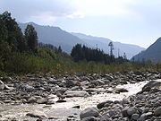
Beas River
Encyclopedia


India
India , officially the Republic of India , is a country in South Asia. It is the seventh-largest country by geographical area, the second-most populous country with over 1.2 billion people, and the most populous democracy in the world...
. The river rises in the Himalayas
Himalayas
The Himalaya Range or Himalaya Mountains Sanskrit: Devanagari: हिमालय, literally "abode of snow"), usually called the Himalayas or Himalaya for short, is a mountain range in Asia, separating the Indian subcontinent from the Tibetan Plateau...
in central Himachal Pradesh
Himachal Pradesh
Himachal Pradesh is a state in Northern India. It is spread over , and is bordered by the Indian states of Jammu and Kashmir on the north, Punjab on the west and south-west, Haryana and Uttar Pradesh on the south, Uttarakhand on the south-east and by the Tibet Autonomous Region on the east...
, India
India
India , officially the Republic of India , is a country in South Asia. It is the seventh-largest country by geographical area, the second-most populous country with over 1.2 billion people, and the most populous democracy in the world...
, and flows for some 470 km (290 miles) to the Sutlej River in the Indian state of Punjab.
Its total length is 460 kilometres (285.8 mi) and its drainage basin
Drainage basin
A drainage basin is an extent or an area of land where surface water from rain and melting snow or ice converges to a single point, usually the exit of the basin, where the waters join another waterbody, such as a river, lake, reservoir, estuary, wetland, sea, or ocean...
is 20303 square kilometres (7,839 sq mi) large.
Etymology
The river was also known as Arjikuja of the VedasVedas
The Vedas are a large body of texts originating in ancient India. Composed in Vedic Sanskrit, the texts constitute the oldest layer of Sanskrit literature and the oldest scriptures of Hinduism....
or Vipasa to the ancient Indians and the Hyphasis to the Ancient Greeks
Ancient Greece
Ancient Greece is a civilization belonging to a period of Greek history that lasted from the Archaic period of the 8th to 6th centuries BC to the end of antiquity. Immediately following this period was the beginning of the Early Middle Ages and the Byzantine era. Included in Ancient Greece is the...
.
The present name Beas is thought to be a corruption of the older name and original name Vipasha in Sanskrit
Sanskrit
Sanskrit , is a historical Indo-Aryan language and the primary liturgical language of Hinduism, Jainism and Buddhism.Buddhism: besides Pali, see Buddhist Hybrid Sanskrit Today, it is listed as one of the 22 scheduled languages of India and is an official language of the state of Uttarakhand...
. The river got this name, Vi-pasha, the one who removed the bondage or pasha in Sanskrit), according to ancient texts, the river was named after sage Vasistha
Vasistha
Vashist in the seventh, i.e the present Manvantara, and the Rajpurohit / Rajguru of the Suryavansha or Solar Dynasty. He was the mānasaputra of Brahma. He had in his possession the divine cow Kamadhenu, and Nandini her child, who could grant anything to their owners...
. Vasistha, tried to end his life due to the death of his 100 sons, by jumping into this river and tying himself. But as soon as the sage fell into the river, all the knots got untied and he did not die. The river is also referred to as Vipasha in Himachal, especially by the scholars.
It is said that Beas is a misnomer for Vayasa (exchange of B with V and always truncation of the last vowel is common in North Indian languages) and is named after Veda Vyasa, the presiding patron of the river, he is said to have created it from its source lake, the Vyas Kund.
History
The Beas River marks the eastern-most border of Alexander's conquests in 326 BC. It was also one of the rivers which created problem in Alexander's invasion towards Bharat (ancient Indian name). His trooped mutinied here in 326 BCE, refusing to go any further; they had been away from home for 8 years. Alexander shut himself in his tent for three days, but when his men did not change their desires he gave in.According to Kavyamimansa of Rajasekhara
Rajasekhara
Rajashekhara was an eminent Sanskrit poet, dramatist and critic. He was court poet of the Gurjara Pratiharas.He wrote Kavyamimamsa between 880 and 920 CE. The work is essentially a practical guide for poets that explains the elements and composition of a good poem. The fame of Rajashekhara...
, the kingdom-territories of Gurjara-Pratihara monarch Mahipala I
Mahipala I
Mahipala I was ascended to the throne of Gurjara-Pratihara dynasty after his step brother Bhoj II. He was born of queen Mahidevi. Mahipala I was also designated by names - Ksitipala, Vinayakapala, Herambapala and Uttarapatha Swami....
was extended till the upper course of the river Bias in the north-west.
In the 20th Century, the river was developed under the Beas Project for irrigation and hydroelectric power generation purposes. The second-phase Pong Dam
Pong Dam
The Pong Dam, also known as the Beas Dam, is an earth-fill embankment dam on the Beas River just upstream of Talwara in the state of Himachal Pradesh, India. The purpose of the dam is water storage for irrigation and hydroelectric power generation. As the second phase of the Beas Project,...
was completed in 1974 followed by the first-phase 140 km (87 mi) upstream, Pandoh Dam
Pandoh Dam
The Pandoh Dam is an embankment dam on the Beas River in Mandi district of Himachal Pradesh, India. Under the Beas Project, the dam was completed in 1977 and its primary purpose is hydroelectric power generation. Part of a run-of-the-river power scheme, it diverts the waters of the Beas to the...
in 1977. The Pong Dam served initially to primarily provide irrigation below Talwara
Talwara
Talwara is a census town in Hoshiarpur district in the Indian state of Punjab.-Geography:Talwara is located at . It has an average elevation of 326 metres .-Demographics:...
but was soon developed as well for power generation; its power station has a 360 MW installed capacity. The Pandoh Dam diverts the river through a system of tunnels and channels to the 990 MW Dehar Power Station on the Sutlej River, connecting both rivers.
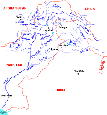
Course
The Beas River originates at an elevation of 3960 metres (12,992.1 ft) in Rohtang PassRohtang Pass
Rohtang Pass , is a high mountain pass on the eastern Pir Panjal Range of the Himalayas some from Manali...
in the Punjab Himalayas of Himachal Pradesh
Himachal Pradesh
Himachal Pradesh is a state in Northern India. It is spread over , and is bordered by the Indian states of Jammu and Kashmir on the north, Punjab on the west and south-west, Haryana and Uttar Pradesh on the south, Uttarakhand on the south-east and by the Tibet Autonomous Region on the east...
. It flows south past Manali and through the Kullu Valley before entering the Punjab plains. It meets the Sutlej River near the Harike Wetland
Harike Wetland
Harike Wetland also known as "Hari-ke-Pattan", with the Harike Lake in the deeper part of it, is the largest wetland in northern India in the Tarn Taran Sahib district of the Punjab state in India. The wetland and the lake were formed by constructing the Head works across the Sutlej river, in...
south of Amritsar
Amritsar
Amritsar is a city in the northern part of India and is the administrative headquarters of Amritsar district in the state of Punjab, India. The 2001 Indian census reported the population of the city to be over 1,500,000, with that of the entire district numbering 3,695,077...
. The Sutlej continues into Pakistani Punjab
Punjab (Pakistan)
Punjab is the most populous province of Pakistan, with approximately 45% of the country's total population. Forming most of the Punjab region, the province is bordered by Kashmir to the north-east, the Indian states of Punjab and Rajasthan to the east, the Pakistani province of Sindh to the...
and joins the Chenab River
Chenab River
The Chenab River چنRiver' آب) is a major river of Jammu and Kashmir and the Punjab in Pakistan. It forms in the upper Himalayas in the Lahaul and Spiti district of Himachal Pradesh, India, and flows through the Jammu region of Jammu and Kashmir into the plains of the Punjab, Pakistan...
at Uch
Uch
Uch or Uch Sharif ) is located in 75 km from Bahawalpur in Bahawalpur District, South Punjab, Pakistan Uch is an important historical city, being founded by Alexander the Great. Formerly located at the confluence of the Indus and Chenab rivers, it is now removed to Mithankot, some 100 km...
near Bahawalpur to form the Panjnad River
Panjnad River
Panjnad River is a river at the extreme end of Bahawalpur district in Punjab, Pakistan. Panjnad River is formed by successive confluence of the five rivers of Punjab, namely Jhelum, Chenab, Ravi, Beas and Sutlej...
; the latter in turn joins the Indus River
Indus River
The Indus River is a major river which flows through Pakistan. It also has courses through China and India.Originating in the Tibetan plateau of western China in the vicinity of Lake Mansarovar in Tibet Autonomous Region, the river runs a course through the Ladakh district of Jammu and Kashmir and...
at Mithankot
Mithankot
Mithankot , is located in southern Punjab, Pakistan.- Geography :Mithankot is located on the right bank of the Indus River, only a short distance downstream from its junction with Panjnad River. The latter is formed by successive confluence of the five rivers of Punjab, namely Jhelum, Chenab,...
.
The waters of the Ravi, Beas (Vipasha) and Sutlej (also known as Shathadru) rivers are allocated to India under the Indus Waters Treaty
Indus Waters Treaty
The Indus Waters Treaty is a water-sharing treaty between the Republic of India and Islamic Republic Of Pakistan, brokered by the World Bank . The treaty was signed in Karachi on September 19, 1960 by Indian Prime Minister Jawaharlal Nehru and President of Pakistan Mohammad Ayub Khan...
between India and Pakistan
Pakistan
Pakistan , officially the Islamic Republic of Pakistan is a sovereign state in South Asia. It has a coastline along the Arabian Sea and the Gulf of Oman in the south and is bordered by Afghanistan and Iran in the west, India in the east and China in the far northeast. In the north, Tajikistan...
.
Dangers
The Beas river is one of India's rougher rivers. Villagers in local towns accidentally slip into the river quite often, never making it back up due to the rough waters, rocks, and undertowsUndertow (wave action)
Undertow is a subsurface flow of water returning seaward from shore as result of wave action. This type of shore current can play a role in material deposition such as creating sand bars....
. It is also extremely polluted, and in some areas it gives off an unpleasant odour.