
Meghna River
Encyclopedia

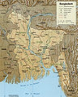
Bangladesh
Bangladesh , officially the People's Republic of Bangladesh is a sovereign state located in South Asia. It is bordered by India on all sides except for a small border with Burma to the far southeast and by the Bay of Bengal to the south...
, one of the three that forms the Ganges Delta
Ganges Delta
The Ganges Delta is a river delta in the South Asia region of Bengal, consisting of Bangladesh and the state of West Bengal, India. It is the world's largest delta, and empties into the Bay of Bengal...
, the largest on earth fanning out to the Bay of Bengal. Being a part of the Surma-Meghna River System
Surma-Meghna River System
The Surma-Meghna River System is a river complex in South Asia, one of the three that form the Ganges Delta, the largest on earth. It rises in the Manipur Hills of northeast India as the Barak River and flows west becoming the Surma River and then flows south as the Meghna River, a total of...
, Meghna is formed inside Bangladesh by the joining of different rivers originaing from the hilly regions of eastern India
India
India , officially the Republic of India , is a country in South Asia. It is the seventh-largest country by geographical area, the second-most populous country with over 1.2 billion people, and the most populous democracy in the world...
. The river meets Padma River
Padma River
The Padma is a major trans-boundary river in Bangladesh. It is the main distributary of the Ganges , which originates in the Himalayas. The Padma enters Bangladesh from India near Chapai Nababganj...
in Chandpur District
Chandpur District
Chandpur is a district in east-central Bangladesh. It is located at the mouth of the Meghna River. It is a part of the Chittagong Division. The town of Chandpur is terminus of a metre gauge branch of Bangladesh Railways. It also has a water terminal situated here.-Geography:Chandpur district has a...
. The river ultimately flows into the Bay of Bengal
Bay of Bengal
The Bay of Bengal , the largest bay in the world, forms the northeastern part of the Indian Ocean. It resembles a triangle in shape, and is bordered mostly by the Eastern Coast of India, southern coast of Bangladesh and Sri Lanka to the west and Burma and the Andaman and Nicobar Islands to the...
in Bhola District
Bhola District
Bhola is a district in south-western Bangladesh. It is located in the Barisal Division. It is also the largest offshore island region in Bangladesh, with an area of 3403.48 km²...
.
Major tributaries of the Meghna include the Dhaleshwari River
Dhaleshwari River
The Dhaleshwari River is a 160-km-long distributary of the Jamuna River in central Bangladesh. It starts off the Jamuna near the northwestern tip of Tangail District. After that it divides into two branches: the north branch retains the name Dhaleshwari and merges with the other branch, the...
, Gumti River
Gumti River, Tripura
Gumti River originates from Dumbur in the northeastern hilly region of Tripura state of India. From its source it flows about 150 km along a meandering course through the hills, turns west and enters Bangladesh near Katak Bazar . Then it takes a meandering course again and passes through the...
, and Feni River
Feni River
Feni River is a river in the Indian state of Tripura and southeastern Bangladesh. It is a trans-boundary river with an on-going dispute.But recently India, Bangladesh finalised deal on Teesta, Feni river waters...
. The Meghna empties into the Bay of Bengal via four principal mouths, named Tetulia, Shahbazpur, Hatia, and Bamni.
The Meghna is the widest river among those that flow completely inside the boundaries of Bangladesh. At one point near Bhola
Bhola District
Bhola is a district in south-western Bangladesh. It is located in the Barisal Division. It is also the largest offshore island region in Bangladesh, with an area of 3403.48 km²...
, Meghna is 12 km wide. In its lower reaches this river follows almost a straight line in its path. Despite its very calm and quiet look, this river is the cause of many deaths every year. Several ferry sinkings in the past have killed hundreds, like the MV Salahuddin-2
MV Salahuddin-2
MV Salahuddin-2 was a ferry that sunk in the Meghna River south of Dhaka, Bangladesh on the night of May 3, 2002, killing more than 450 people.-External links:* *...
and the MV Nasrin-1
MV Nasrin-1
MV Nasrin-1 was a ferry that sunk in the Meghna River near Chandpur, Bangladesh, on the midnight of July 8, 2003, killing more than 400 people.-External links:*...
. Near Chandpur
Chandpur District
Chandpur is a district in east-central Bangladesh. It is located at the mouth of the Meghna River. It is a part of the Chittagong Division. The town of Chandpur is terminus of a metre gauge branch of Bangladesh Railways. It also has a water terminal situated here.-Geography:Chandpur district has a...
it is very dangerous.
The river's average depth is 1012 feet (308.5 m) and maximum depth is 1620 feet (493.8 m). In the origin of Hatiya
Hatiya
Hatiya is an island and also an Upazila of Noakhali District in the Division of Chittagong, Bangladesh.-Geography:Hatiya is located at . It has 47970 units of house hold and total area 1508.23 km²....
and Bhola, the deepest point is the Meghna River Creek, it reaches 1998 feet (609 m).
Course
The Meghna is a distributary of the great river Brahmaputra. The Meghna is formed inside BangladeshBangladesh
Bangladesh , officially the People's Republic of Bangladesh is a sovereign state located in South Asia. It is bordered by India on all sides except for a small border with Burma to the far southeast and by the Bay of Bengal to the south...
by the joining of the Surma
Surma River
The Surma River is a major river in Bangladesh, part of the Surma-Meghna River System. It starts when the Barak River from northeast India divides at the Bangladesh border into the Surma and the Kushiyara rivers. It ends in Kishoreganj District, above Bhairab Bazar, where the two rivers rejoin to...
and Kushiyara
Kushiyara River
The Kushiyara River is one of the many rivers in Bangladesh that crosses international boundaries. It is a branch of the Barak River, which originates in the state of Manipur in India and runs along the border of the Indian states of Manipur & Mizoram before getting split into Surma and Kushiyara...
rivers originating from the hilly regions of eastern India
India
India , officially the Republic of India , is a country in South Asia. It is the seventh-largest country by geographical area, the second-most populous country with over 1.2 billion people, and the most populous democracy in the world...
. Down to Chandpur
Chandpur
Chandpur is one of the most important city in Bijnor district, in the state of Uttar Pradesh, India.Chandpur is 140 km from the capital of New Delhi, 110 km from Meerut, and 38 km from Gajraula on National Highway 24 ....
, Meghna is hydrographically referred to as the Upper Meghna. After the Padma joins, it is referred to as the Lower Meghna.
Near Muladhuli in Barisal district, the Safipur River is an offshoot of the Surma that creates one of the main rivers in South Bengal. 1.5 km wide, this river is one of the widest in the country as well.
At Ghatalpur of Brahmanbaria District
Brahmanbaria District
Brahmanbaria is a district in east-central Bangladesh. It is a part of the Chittagong Division. It was part of greater Comilla District until 1984. Before 1830 the Sarail Pargana was a part of Mymensingh district...
, the river Titas
Titas River
Titas River is a trans-boundary river of south-eastern Bangladesh. It originates in the state of Tripura in India where it is known as Haora River in Bengali and Saidra in the local Kokborok language...
emerges from Meghna and after circling two large bends by 240 km, falls into the Meghna again near Nabinagar Upazila
Nabinagar Upazila
Nabinagar is an Upazila of Brahmanbaria District in the Division of Chittagong, Bangladesh.-Geography:Nabinagar is located at . It has 63,691 households and a total area of 353.66 km².-Demographics:...
. Titas forms as a single stream but braids into two distinct streams which remain separate before re-joining the Meghna.
Comilla District
The district of Comilla consists 4543 mosques, 379 temples, 98 churches, 34 Buddhist temples and six tombs.-Places of interest:Important landmarks include Kotbari, a cantonment, or military installation and Kandirpar, considered the heart of the Comilla district...
, Meghna is joined by the great river Gomoti, created by the combination of many streams. This river reinforces Meghna a lot and increases the waterflow considerably. The pair of bridges over Meghna and Gomoty are two of the country's largest bridges. The Dakatua River
Dakatua River
The Dakatua River or Dakatia is a river of Bangladesh and India. The length of the Dakatia is about 207 km. After entering India in the Comilla district, it joins the Meghna River at Raipur....
is also part of the river system in Comilla district.
Meghna is reinforced by the Dhaleshwari before Chandpur as well. The name for the largest distributary of the Ganges in Bangladesh is the Padma River
Padma River
The Padma is a major trans-boundary river in Bangladesh. It is the main distributary of the Ganges , which originates in the Himalayas. The Padma enters Bangladesh from India near Chapai Nababganj...
. When the Padma joins with the Jamuna River, the largest distributary of the Brahmaputra, and they join with the Meghna in Chandpur District
Chandpur District
Chandpur is a district in east-central Bangladesh. It is located at the mouth of the Meghna River. It is a part of the Chittagong Division. The town of Chandpur is terminus of a metre gauge branch of Bangladesh Railways. It also has a water terminal situated here.-Geography:Chandpur district has a...
, the result in Bangladesh is called the Lower Meghna. When the brown and hazy water of the Padma mix with the clear water of the Upper Meghna, the two streams do not mix but flow in parallel down to the sea - making half of the river clear and the other half brown. This peculiarity of the river is always a great attraction for people.
After Chandpur
Chandpur District
Chandpur is a district in east-central Bangladesh. It is located at the mouth of the Meghna River. It is a part of the Chittagong Division. The town of Chandpur is terminus of a metre gauge branch of Bangladesh Railways. It also has a water terminal situated here.-Geography:Chandpur district has a...
, when the river has the combined flow of the Padma and Jamuna it moves down to the Bay of Bengal
Bay of Bengal
The Bay of Bengal , the largest bay in the world, forms the northeastern part of the Indian Ocean. It resembles a triangle in shape, and is bordered mostly by the Eastern Coast of India, southern coast of Bangladesh and Sri Lanka to the west and Burma and the Andaman and Nicobar Islands to the...
in an almost straight line. In her course from Chandpur to Bay of Bengal, the Meghna braids into a number of little rivers including the Pagli, Katalia, Dhonagoda, Matlab and Udhamodi. All of these rivers flow out from the Meghna and rejoin again at points downstream.
Near Bhola
Bhola District
Bhola is a district in south-western Bangladesh. It is located in the Barisal Division. It is also the largest offshore island region in Bangladesh, with an area of 3403.48 km²...
, just before flowing into the Bay of Bengal, the river divides into two main streams in the Ganges delta and separates an island from both sides of the mainland. The western stream is called Ilsha and the eastern one is called Bamni.
See also
- Surma-Meghna river systemSurma-Meghna River SystemThe Surma-Meghna River System is a river complex in South Asia, one of the three that form the Ganges Delta, the largest on earth. It rises in the Manipur Hills of northeast India as the Barak River and flows west becoming the Surma River and then flows south as the Meghna River, a total of...
- List of rivers in Bangladesh
- Banglapedia article on Meghna River