The
Andaman Sea or
Burma Sea is a body of water to the southeast of the
Bay of BengalThe Bay of Bengal , the largest bay in the world, forms the northeastern part of the Indian Ocean. It resembles a triangle in shape, and is bordered mostly by the Eastern Coast of India, southern coast of Bangladesh and Sri Lanka to the west and Burma and the Andaman and Nicobar Islands to the...
, south of Burma, west of
ThailandThailand , officially the Kingdom of Thailand , formerly known as Siam , is a country located at the centre of the Indochina peninsula and Southeast Asia. It is bordered to the north by Burma and Laos, to the east by Laos and Cambodia, to the south by the Gulf of Thailand and Malaysia, and to the...
and east of the
Andaman IslandsThe Andaman Islands are a group of Indian Ocean archipelagic islands in the Bay of Bengal between India to the west, and Burma , to the north and east...
,
IndiaIndia , officially the Republic of India , is a country in South Asia. It is the seventh-largest country by geographical area, the second-most populous country with over 1.2 billion people, and the most populous democracy in the world...
; it is part of the
Indian OceanThe Indian Ocean is the third largest of the world's oceanic divisions, covering approximately 20% of the water on the Earth's surface. It is bounded on the north by the Indian Subcontinent and Arabian Peninsula ; on the west by eastern Africa; on the east by Indochina, the Sunda Islands, and...
.
The sea has been traditionally used for fishery and transportation of goods between the coastal countries and its
coral reefCoral reefs are underwater structures made from calcium carbonate secreted by corals. Coral reefs are colonies of tiny living animals found in marine waters that contain few nutrients. Most coral reefs are built from stony corals, which in turn consist of polyps that cluster in groups. The polyps...
s and islands are popular tourist destinations. The fishery and tourist infrastructure has been severely damaged by the 2004 Indian Ocean earthquake and tsunami.
Extent
At its southeastern reaches, the Andaman Sea narrows to form the Straits of Malacca, which separate the
Malay PeninsulaThe Malay Peninsula or Thai-Malay Peninsula is a peninsula in Southeast Asia. The land mass runs approximately north-south and, at its terminus, is the southern-most point of the Asian mainland...
from the island of
SumatraSumatra is an island in western Indonesia, westernmost of the Sunda Islands. It is the largest island entirely in Indonesia , and the sixth largest island in the world at 473,481 km2 with a population of 50,365,538...
.
The
International Hydrographic OrganizationThe International Hydrographic Organization is the inter-governmental organisation representing the hydrographic community. It enjoys observer status at the UN and is the recognised competent authority on hydrographic surveying and nautical charting...
defines the limits of the "Andaman or Burma Sea" as follows:
On the Southwest. A line running from Oedjong Raja (5°32′N 95°12′E) in SumatraSumatra is an island in western Indonesia, westernmost of the Sunda Islands. It is the largest island entirely in Indonesia , and the sixth largest island in the world at 473,481 km2 with a population of 50,365,538...
to Poeloe Bras (Breuëh) and on through the Western Islands of the NicobarThe Nicobar Islands are an archipelagic island chain in the eastern Indian Ocean...
Group to Sandy Point in Little Andaman Island, in such a way that all the narrow waters appertain to the Burma Sea.
On the Northwest. The Eastern limit of the Bay of Bengal [A line running from Cape NegraisCape Negrais is a cape in Burma , 193 kilometres from the Indian union territory of the Andaman and Nicobar Islands....
(16°03'N) in Burma through the larger islands of the AndamanThe Andaman Islands are a group of Indian Ocean archipelagic islands in the Bay of Bengal between India to the west, and Burma , to the north and east...
group, in such a way that all the narrow waters between the islands lie to the Eastward of the line and are excluded from the Bay of Bengal, as far as a point in Little AndamanLittle Andaman island is the fourth largest of the Andaman Islands of India with an area of 734.39 km², lying at the southern end of the archipelago. It is separated from Rutland Island in Great Andaman by the Duncan Passage. It is home to the Onge tribe, who call the island Egu Belong, and...
Island].
On the Southeast. A line joining Lem Voalan (7°47'N) in Siam [ThailandThailand , officially the Kingdom of Thailand , formerly known as Siam , is a country located at the centre of the Indochina peninsula and Southeast Asia. It is bordered to the north by Burma and Laos, to the east by Laos and Cambodia, to the south by the Gulf of Thailand and Malaysia, and to the...
], and Pedropunt (5°40'N) in Sumatra.
Geology
The average depth of the sea is about 1,000 meters (3,300 ft). The northern and eastern parts are shallower than 180 meters (600 ft) due to the
siltSilt is granular material of a size somewhere between sand and clay whose mineral origin is quartz and feldspar. Silt may occur as a soil or as suspended sediment in a surface water body...
deposited by the Irrawaddy River. This major river flows into the sea from the north through Burma. The western and central areas are 900–3,000 meters deep (3,000–10,000 ft). Less than 5% of the sea is deeper than 3,000 meters (10,000 ft), and in a system of submarine valleys east of the Andaman-Nicobar Ridge, the depth exceeds 4,000 meters (13,200 ft). The sea floor is covered with pebbles, gravel and sand.
Hydrology and climate
The climate and water
salinitySalinity is the saltiness or dissolved salt content of a body of water. It is a general term used to describe the levels of different salts such as sodium chloride, magnesium and calcium sulfates, and bicarbonates...
of the Andaman Sea are mostly determined by the monsoons of southeast Asia. Air temperature is stable over the year at 26 °C in February and 27 °C in August. Precipitation is as high as 3,000 mm/year and mostly occurs in summer. Sea currents are south-easterly and easterly in winter and south-westerly and westerly in summer. The average surface water temperature is 26–28 °C in February and 29 °C in May. The water temperature is constant at 4.8 °C at the depths of 1,600 m and below. Salinity is 31.5–32.5‰ (parts per thousand) in summer and 30.0–33.0‰ in winter in the southern part. In the northern part, it decreases to 20–25‰ due to the inflow of fresh water from the Irrawaddy River.
TideTides are the rise and fall of sea levels caused by the combined effects of the gravitational forces exerted by the moon and the sun and the rotation of the Earth....
s are semidiurnal (i.e. rising twice a day) with the amplitude of up to 7.2 meters.
Flora
The coastal areas of the Andaman Sea are characterized by
mangroveMangroves are various kinds of trees up to medium height and shrubs that grow in saline coastal sediment habitats in the tropics and subtropics – mainly between latitudes N and S...
forests and
seagrassSeagrasses are flowering plants from one of four plant families , all in the order Alismatales , which grow in marine, fully saline environments.-Ecology:...
meadows. Mangroves cover between more than 600 km² (232 sq mi) of the Thai shores of Malay Peninsula whereas seagrass meadows occupy an area of 79 km² (31 sq mi). Mangroves are largely responsible for the high productivity of the coastal waters – their roots trap soil and sediment and provide shelter from predators and nursery for fish and small aquatic organisms. Their body protects the shore from the wind and waves, and their
detritusDetritus is a biological term used to describe dead or waste organic material.Detritus may also refer to:* Detritus , a geological term used to describe the particles of rock produced by weathering...
are a part of the aquatic food chain. A significant part of the Thai mangrove forests in the Andaman Sea was removed during the extensive
brackish water shrimpThe genus Palaemonetes includes a geographically diverse group of fresh and brackish-water shrimp. It includes the following species:*Palaemonetes africanus Balss, 1916*Palaemonetes antennarius The genus Palaemonetes includes a geographically diverse group of fresh and brackish-water shrimp. It...
. Mangroves were also significantly damaged by the 2004 tsunami. They were partly replanted after that, but their area is still gradually decreasing due to human activities.
Other important sources of nutrients in the Andaman Sea are seagrass and the mud bottoms of lagoons and coastal areas. They also create a habitat or temporal shelter for many burrowing and benthic organisms. Many aquatic species migrate from and to seagrass either daily or at certain stages of their life cycle. The human activities which damage seagrass beds include waste water discharge from coastal industry, shrimp farms and other forms of coastal development, as well as trawling and the use of push nets and dragnets. The 2004 tsunami affected 3.5% of seagrass areas along the Andaman Sea via
siltationSiltation is the pollution of water by fine particulate terrestrial clastic material, with a particle size dominated by silt or clay. It refers both to the increased concentration of suspended sediments, and to the increased accumulation of fine sediments on bottoms where they are undesirable...
and sand sedimentation and 1.5% suffered total habitat loss.
Fauna
The sea waters along the
Malay PeninsulaThe Malay Peninsula or Thai-Malay Peninsula is a peninsula in Southeast Asia. The land mass runs approximately north-south and, at its terminus, is the southern-most point of the Asian mainland...
favor molluscan growth, and there are about 280 edible fish species belonging to 75 families. Of those, 232 species (69 families) are found in mangroves and 149 species (51 families) reside in seagrass; so 101 species are common to both habitats. The sea also hosts many vulnerable fauna species, including
dugongThe dugong is a large marine mammal which, together with the manatees, is one of four living species of the order Sirenia. It is the only living representative of the once-diverse family Dugongidae; its closest modern relative, Steller's sea cow , was hunted to extinction in the 18th century...
(
Dugong dugon), several dolphin species, such as
Irrawaddy DolphinThe Irrawaddy dolphin is a euryhaline species of oceanic dolphin found in discontinuous subpopulations near sea coasts and in estuaries and rivers in parts of the Bay of Bengal and Southeast Asia.-Etymology and taxonomic history:...
(
Orcaella brevirostris) and four species of sea turtles: critically endangered leatherback turtle (
Dermochelys coriacea) and
hawksbill turtleThe hawksbill sea turtle is a critically endangered sea turtle belonging to the family Cheloniidae. It is the only extant species in its genus. The species has a worldwide distribution, with Atlantic and Pacific subspecies. E. imbricata imbricata is the Atlantic subspecies, while E...
(Eletmochelys imbricata) and threatened green turtle (
Chelonia mydas) and
Olive RidleyThe olive ridley sea turtle , also known as the Pacific ridley, is a species of sea turtle.- Description :The olive ridley is a small extant sea turtle, with an adult carapace length averaging 60 to 70 cm 1...
turtle (
Lepidochelys olivacea). There are only about 150 dugongs in the Andaman Sea, scattered between
RanongRanong is one of the southern provinces of Thailand, on the coast of the Andaman Sea. It is the province with the fewest citizens. Neighboring provinces are Chumphon, Surat Thani and Phang Nga...
and
Satun provinceSatun is one of the southern provinces of Thailand. Neighboring provinces are Trang, Phatthalung and Songkhla...
s. These species are rather sensitive to the degradation of seagrass meadows.
Human activities
The sea has been used for fishing and transportation of goods between the coastal countries. Thailand alone has produced about 943,000 tonnes in 2005 and about 710,000 tonnes in 2000. Of those 710,000 tonnes, 490,000 account for
trawlingTrawling is a method of fishing that involves pulling a fishing net through the water behind one or more boats. The net that is used for trawling is called a trawl....
(1,017 vessels), 184,000 for purse seine (415 vessels) and about 30,000 for
gillnetGillnetting is a common fishing method used by commercial and artisanal fishermen of all the oceans and in some freshwater and estuary areas. The gillnet also is used by fisheries scientists to monitor fish populations. Because gillnets can be so effective their use is closely monitored and...
s. The production numbers are significantly smaller for Malaysia and are comparable, or higher, for Burma. Competition for fish resulted in numerous conflicts between Burma and Thailand. In 1998 and 1999, they resulted in fatalities on both sides and nearly escalated into a military conflict between these countries. In both cases, Thai navy intervened when Burmese vessels tried to intercept Thai fishing boats in the contested sea areas, and Thai fighter aircraft were thought to be deployed by the National Security Council. Thai fishing boats were also frequently confronted by the Malaysian navy to the extent that Thai government had to caution its own fishermen against fishing without license, in foreign waters.
The 2004 marine production in Thailand was divided as follows:
pelagic fishPelagic fish live near the surface or in the water column of coastal, ocean and lake waters, but not on the bottom of the sea or the lake. They can be contrasted with demersal fish, which do live on or near the bottom, and reef fish which are associated with coral reefs.The marine pelagic...
33%, demersal fish 18%,
cephalopodA cephalopod is any member of the molluscan class Cephalopoda . These exclusively marine animals are characterized by bilateral body symmetry, a prominent head, and a set of arms or tentacles modified from the primitive molluscan foot...
7.5%, crustaceans 4.5%, trash fish 30% and others 7%. Trash fish refers to non-edible species, edible species of low commercial value and juveniles, which are released to the sea. Pelagic fishes were distributed between anchovies (
Stolephorus spp., 19%), Indo-Pacific mackerel (
RastrelligerRastrelliger is a mackerel genus in the family Scombridae.-Species:* Short mackerel, Rastrelliger brachysoma .* Island mackerel, Rastrelliger faughni Matsui, 1967.* Indian mackerel, Rastrelliger kanagurta ....
brachysoma, 18%),
sardinellaSardinellaSardinella is a genus of fishes in the family Clupeidae. This genus currently contains 21 recognized species. These fish are generally coastal, schooling fish, and abundant in warmer waters. They can be found nearly anywhere in the tropic and subtropic oceans of the World...
s (
Sardinellars spp., 14%),
scadDecapterus is a genus of marine fishes in the family in the jack family, Carangidae. They are commonly known as mackerel scads, and round scads. They are found throughout the world....
(11%), longtail tuna (
Thunnus tonggolThunnus tonggol is a tuna of tropical Pacific waters known generally as tonggol tuna.Due to vagueries of naming regulations Thunnus tongol may legally, albeit confusingly, be called northern bluefin in Australia.-External links:...
, 9%), eastern little tuna (
Euthynnus affinis, 6%),
trevalliesCarangidae is a family of fish which includes the jacks, pompanos, jack mackerels, and scads.They are marine fish found in the Atlantic, Indian and Pacific Oceans...
(6%),
bigeye scadThe bigeye scad is an oceanic fish that is found around the globe in tropical regions. Other common names include akule, chicharro, charrito ojón, purse-eye scad, coulirou, and goggle-eyed scad. Bigeye scads are fished commercially and are very important to aquaculture.Bigeye scads are blue-green...
(5%),
Indian mackerelThe Indian mackerel is a species ofmackerel in the scombrid family of orderPerciformes. It is commonlyfound in the Indian and WestPacific oceans, and their surrounding seas...
(
Rastrelliger kanagurta, 4%),
king mackerelThe king mackerel is a migratory species of mackerel of the western Atlantic Ocean and Gulf of Mexico. It is an important species to both the commercial and recreational fishing industries.-Description:...
(
Scomberomorus cavalla, 3%),
torpedo scadThe torpedo scad, Megalaspis cordyla , is a species of moderately large marine fish classified in the jack and horse mackerel family, Carangidae...
(
Megalaspis cordyla , 2%),
wolf herringThe wolf herrings are a family of two marine species of ray-finned fish related to the herrings.Both species have elongated bodies and jaws with long sharp teeth that facilitate their ravenous appetites, mostly for other fish. Both species reach a length of 1 m...
s (1%) and others (2%). Demersal fish production was dominated by
purple-spotted bigeyePriacanthidae is a family of fish, common name bigeye, comprising 18 species of marine fishes. "Catalufa" is an alternate common name for some members of the priacanthidae family. The etymology of the scientific name refers to the family's very rough, spined scales...
(
Priacanthus tayenus),
threadfin breamThe threadfin breams are a family, Nemipteridae, of fishes in the order Perciformes. They are also known as whiptail breams and false snappers.They are found in tropical waters of the Indian and western Pacific Oceans...
(
Nemipterus hexodon),
brushtooth lizardfishThe Brushtooth lizardfish is a type of lizardfish that lives mainly in the Red Sea region....
(
Saurida undosquamis),
slender lizardfishThe Slender lizardfish which is also known as Saurida elongata is a type of lizardfish or Synodontidae that lives mainly in the Northwest Pacific....
(
Saurida elongata) and Jinga shrimp (
Metapenaeus affinis). Most species are overfished since 1970s–1990s, except for
Spanish mackerelSpanish mackerel may refer to:* Chloroscombrus chrysurus* Elagatis bipinnulata* Schedophilus maculatus* Scomber japonicus* Scomberomorus brasiliensis* Scomberomorus cavalla* Scomberomorus commerson* Scomberomorus guttatus...
(
Scomberomorus commersoni),
carangidaeCarangidae is a family of fish which includes the jacks, pompanos, jack mackerels, and scads.They are marine fish found in the Atlantic, Indian and Pacific Oceans...
and
torpedo scadThe torpedo scad, Megalaspis cordyla , is a species of moderately large marine fish classified in the jack and horse mackerel family, Carangidae...
(
Meggalaspis spp.). The overal
overfishingOverfishing occurs when fishing activities reduce fish stocks below an acceptable level. This can occur in any body of water from a pond to the oceans....
rate was 333% for pelagic and 245% for demersal species in 1991. Cephalopods are divided into squid,
cuttlefishCuttlefish are marine animals of the order Sepiida. They belong to the class Cephalopoda . Despite their name, cuttlefish are not fish but molluscs....
and molluscs, where squid and cuttlefish in Thai waters consists of 10 families, 17 genera and over 30 species. The main mollusk species captured in the Andaman Sea are
scallopA scallop is a marine bivalve mollusk of the family Pectinidae. Scallops are a cosmopolitan family, found in all of the world's oceans. Many scallops are highly prized as a food source...
,
blood cockleAnadara granosa is a species of ark clam known as the blood cockle due to the red haemoglobin liquid inside. It is found throughout the Indo-Pacific region from eastern Africa to Australia to Polynesia to Japan. It lives mainly in the intertidal zone at one to two metres water depth, burrowed down...
(
Anadara granosa) and short-necked clam. Their collection requires bottom dredge gears, which damage the sea floor and the gears themselves and are becoming unpopular. So, the mollusk production has decreased from 27,374 tonnes in 1999 to 318 tonnes in 2004. While crustaceans composed only 4.5% of the total marine products in 2004 by volume, they accounted for 21% of the total value. They were dominated by
banana prawnThe Indian prawn, Fenneropenaeus indicus , is one of the major commercial prawn species of the world. It is found in the Indo-West Pacific from eastern and south-eastern Africa, through India, Malaysia and Indonesia to southern China and northern Australia.-Common names:F...
,
tiger prawnPenaeus monodon, the giant tiger prawn , is a marine crustacean that is widely reared for food.-Distribution:...
, king prawn, school prawn, bay lobster (
Thenus orientalis), mantis shrimp, swimming crabs and
mud crabMud crab may refer to any crab that lives in or near mud, such as:*Scylla serrata, also called mangrove crab and black crab.*Scylla tranquebarica, another variety of the mangrove crab.*Scylla paramamosain...
s. The total catch in 2004 was 51,607 tonnes for squid and cuttlefish and 36,071 tonnes for crustaceans.
The sea’s mineral resources include
tinTin is a chemical element with the symbol Sn and atomic number 50. It is a main group metal in group 14 of the periodic table. Tin shows chemical similarity to both neighboring group 14 elements, germanium and lead and has two possible oxidation states, +2 and the slightly more stable +4...
deposits off the coasts of Malaysia and Thailand. Major ports are
Dawei-Transport:Only recently Dawei was connected to the rest of Myanmar by road and rail. There are plans to construct a deepwater port in Dawei. In November 2010, the Myanmar Port Authority signed a USD $8.6 billion deal with Italian-Thai Development to develop a deep sea port at Dawei...
,
MawlamyineMawlamyine is the fourth largest city of Burma , situated 300 km south east of Yangon and 70 km south of Thaton, at the mouth of Thanlwin river...
,
MerguiMyeik is a city in Tanintharyi Division in Myanmar , located in the extreme south of the country on the coast of an island on the Andaman Sea. the estimated population was over 209,000. The area inland from the city is a major smuggling corridor into Thailand.-History:Myeik was the southernmost...
,
PatheinPathein , also called Bassein, is a port city with a 2004 population estimated at 215,600, and the capital of the Ayeyarwady Region, Burma. It lies on the Pathein River , which is a western branch of the Irrawaddy River....
and
YangonYangon is a former capital of Burma and the capital of Yangon Region . Although the military government has officially relocated the capital to Naypyidaw since March 2006, Yangon, with a population of over four million, continues to be the country's largest city and the most important commercial...
in Burma;
George TownGeorge Town was voted as one of the best cities in Asia by Asiaweek, ranked 6th in 1998 and 9th in 2000. More recently, George Town has improved a notch to rank as the 9th most liveable city in Asia in a survey of 254 cities worldwide according to an international location ratings survey by , an...
and
PenangPenang is a state in Malaysia and the name of its constituent island, located on the northwest coast of Peninsular Malaysia by the Strait of Malacca. It is bordered by Kedah in the north and east, and Perak in the south. Penang is the second smallest Malaysian state in area after Perlis, and the...
in Malaysia; and
BelawanBelawan is a port city on the northeast coast of Sumatra, Indonesia. Located on the Deli River near the city of Medan, Belawan is Indonesia's busiest port outside of Java....
in Indonesia.
The Andaman Sea, particularly the western coast of
Malay PeninsulaThe Malay Peninsula or Thai-Malay Peninsula is a peninsula in Southeast Asia. The land mass runs approximately north-south and, at its terminus, is the southern-most point of the Asian mainland...
, is rich in
coral reefCoral reefs are underwater structures made from calcium carbonate secreted by corals. Coral reefs are colonies of tiny living animals found in marine waters that contain few nutrients. Most coral reefs are built from stony corals, which in turn consist of polyps that cluster in groups. The polyps...
s and offshore islands with spectacular topography, such as
PhuketPhuket , formerly known as Thalang and, in Western sources, Junk Ceylon , is one of the southern provinces of Thailand...
,
Phi Phi IslandsThe Phi Phi Islands are located in Thailand, between the large island of Phuket and the western Andaman Sea coast of the mainland. The islands are administratively part of Krabi province...
,
Ko TapuKhao Phing Kan or Ko Khao Phing Kan is a pair of islands on the west coast of Thailand, in the Phang Nga Bay, Andaman Sea. About from its shores lies a 20 meters tall islet Ko Tapu or Khao Tapu . The island is a part of the Ao Phang Nga National Park...
and islands of
Krabi ProvinceKrabi is one of the southern provinces of Thailand, at the shore of the Andaman Sea. Neighbouring provinces are Phang Nga, Surat Thani, Nakhon Si Thammarat and Trang. The Phuket province to the west is also neighbouring, but without any land boundary...
. Despite having been devastated by the 2004 Sumatra earthquake and tsunami, they remain popular tourist destinations. The nearby coast also has numerous marine national parks – 16 only in Thailand, and four of them are candidates for inclusion into
UNESCOThe United Nations Educational, Scientific and Cultural Organization is a specialized agency of the United Nations...
World Heritage SiteA UNESCO World Heritage Site is a place that is listed by the UNESCO as of special cultural or physical significance...
s.
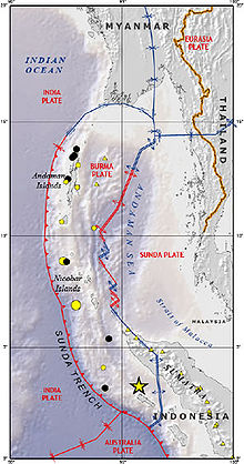
Ocean floor tectonics
Running in a rough north-south line on the seabed of the Andaman Sea is the boundary between two tectonic plates, the
Burma plateThe Burma Plate is a small tectonic plate or microplate located in Southeast Asia, often considered a part of the larger Eurasian Plate. The Andaman Islands, Nicobar Islands, and northwestern Sumatra are located on the plate...
and the
Sunda PlateThe Sunda Plate is the tectonic plate on which the majority of Southeast Asia is located. It was formerly considered a part of the Eurasian Plate, but GPS measurements have confirmed its independent movement at 10 mm/yr eastward relative to Eurasia...
. These plates (or microplates) are believed to have formerly been part of the larger
Eurasian PlateThe Eurasian Plate is a tectonic plate which includes most of the continent of Eurasia , with the notable exceptions of the Indian subcontinent, the Arabian subcontinent, and the area east of the Chersky Range in East Siberia...
, but were formed when
transform faultA transform fault or transform boundary, also known as conservative plate boundary since these faults neither create nor destroy lithosphere, is a type of fault whose relative motion is predominantly horizontal in either sinistral or dextral direction. Furthermore, transform faults end abruptly...
activity intensified as the Indian Plate began its substantive collision with the Eurasian
continentA continent is one of several very large landmasses on Earth. They are generally identified by convention rather than any strict criteria, with seven regions commonly regarded as continents—they are : Asia, Africa, North America, South America, Antarctica, Europe, and Australia.Plate tectonics is...
. As a result, a
back-arc basinBack-arc basins are geologic features, submarine basins associated with island arcs and subduction zones.They are found at some convergent plate boundaries, presently concentrated in the Western Pacific ocean. Most of them result from tensional forces caused by oceanic trench rollback and the...
center was created, which began to form the marginal
basinHydrologically, an oceanic basin may be anywhere on Earth that is covered by seawater, but geologically ocean basins are large geologic basins that are below sea level...
which would become the Andaman Sea, the current stages of which commenced approximately 3–4 million years ago (Ma).
The boundary between two major tectonic plates results in high seismic activity in the region (see :Category:Earthquakes in Indonesia). Numerous earthquakes have been recorded, and at least six, in
1797The 1797 Sumatra earthquake was the first in a series of great earthquakes that ruptured part of the Sumatran segment of the Sunda megathrust. It caused a damaging tsunami that was particularly severe near Padang, where a 150-200 ton English ship was driven 1 km inland up the Arau...
,
1833The 1833 Sumatra earthquake occurred on November 25, 1833, about 22:00 local time, with an estimated magnitude in the range Mw= 8.8–9.2. It caused a large tsunami that flooded the southwestern coast of the island. There are no reliable records of the loss of life, with the casualties being...
,
1861The 1861 Sumatra earthquake occurred on February 16, 1861. It was the last in a sequences of earthquakes that ruptured adjacent parts of the Sumatran segment of the Sunda megathrust. It caused a devastating tsunami which led to several thousand fatalities. The earthquake was felt as far away as the...
, 2004,
2005The 2005 Sumatra earthquake, referred to as the Nias Earthquake by the scientific community, was a major earthquake on 28 March 2005, located off the west coast of northern Sumatra, Indonesia. Approximately 1300 people were killed by the earthquake, mostly on the island of Nias...
and
2007The September 2007 Sumatra earthquakes were a series of megathrust earthquakes that struck the Java Trench off the coast of Sumatra, Indonesia, three greater than magnitude 7. A series of tsunami bulletins was issued for the area...
, had the
magnitudeThe moment magnitude scale is used by seismologists to measure the size of earthquakes in terms of the energy released. The magnitude is based on the seismic moment of the earthquake, which is equal to the rigidity of the Earth multiplied by the average amount of slip on the fault and the size of...
of 8.4 or higher. On December 26, 2004, a large portion of the boundary between the Burma Plate and the Indo-Australian Plate slipped, causing the
2004 Indian Ocean earthquakeThe 2004 Indian Ocean earthquake was an undersea megathrust earthquake that occurred at 00:58:53 UTC on Sunday, December 26, 2004, with an epicentre off the west coast of Sumatra, Indonesia. The quake itself is known by the scientific community as the Sumatra-Andaman earthquake...
. This
megathrust earthquakeMegathrust earthquakes occur at subduction zones at destructive plate boundaries , where one tectonic plate is forced under another. Due to the shallow dip of the plate boundary, which causes large sections to get stuck, these earthquakes are among the world's largest, with moment magnitudes ...
had a magnitude of 9.3. Between 1300 and 1600 kilometers of the boundary underwent
thrust faultA thrust fault is a type of fault, or break in the Earth's crust across which there has been relative movement, in which rocks of lower stratigraphic position are pushed up and over higher strata. They are often recognized because they place older rocks above younger...
ing and shifted by about 20 meters, with the sea floor being uplifted several meters. This rise in the sea floor generated a massive
tsunamiA tsunami is a series of water waves caused by the displacement of a large volume of a body of water, typically an ocean or a large lake...
with an estimated height of 28 meters (30 ft) that killed approximately 280,000 people along the coast of the Indian Ocean. The initial quake was followed by a series of aftershocks along the arc of the Andaman and Nicobar Islands. The entire event severely damaged the tourist and fishing infrastructure. The 2000s energy crisis also adversely affected the fishery.
Volcanic activity
Within the sea, to the east of the main
Great AndamanGreat Andaman is the main archipelago of the Andaman Islands of India. It comprises five major islands. From north to south, these are North Andaman, Middle Andaman, South Andaman, Baratang and Rutland Island...
island group, lies
Barren IslandBarren Island is located in the Andaman Sea, one of the most easterly of the Andaman Islands. It is the only confirmed active volcano in South Asia...
, the only presently active volcano associated with the
Indian subcontinentSouth Asia, also known as Southern Asia, is the southern region of the Asian continent, which comprises the sub-Himalayan countries and, for some authorities , also includes the adjoining countries to the west and the east...
. This island-volcano is 3 km (2 mi) in diameter and rises 354 meters above the seal level. Its recent activity resumed in 1991 after a quiet period of almost 200 years. It is caused by the ongoing
subductionIn geology, subduction is the process that takes place at convergent boundaries by which one tectonic plate moves under another tectonic plate, sinking into the Earth's mantle, as the plates converge. These 3D regions of mantle downwellings are known as "Subduction Zones"...
of the India Plate beneath the Andaman
island arcAn island arc is a type of archipelago composed of a chain of volcanoes which alignment is arc-shaped, and which are situated parallel and close to a boundary between two converging tectonic plates....
, which forces
magmaMagma is a mixture of molten rock, volatiles and solids that is found beneath the surface of the Earth, and is expected to exist on other terrestrial planets. Besides molten rock, magma may also contain suspended crystals and dissolved gas and sometimes also gas bubbles. Magma often collects in...
to rise in this location of the Burma Plate. The last eruption has started on 13 May 2008 and still continues. The volcanic island of
NarcondamNarcondam or Narcondum is a small volcanic island located in the Andaman Sea. Its central peak rises some 710 m above mean sea level, and is formed of andesite. It is considered to be part of the Andaman Islands, the main body of which lie approximately 114 km to the west. The island is part...
which lies further to the north was also formed by this process; however, no records exist of its activity.
The source of this article is
wikipedia, the free encyclopedia. The text of this article is licensed under the
GFDL.