
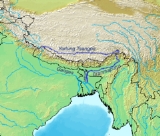
Yarlung Zangbo River
Encyclopedia
Yarlung River is a watercourse
that originates upstream from the South Tibet Valley and Yarlung Zangbo Grand Canyon, in Tibet
. It then passes through the state of Arunachal Pradesh
, India
, where it is known as the Dihang.
It is called Yarlung Zangbo or Yarlung River , or Yalu Zangbu River , or Yarlung Tsangpo (alternative transcription), Yarlung Zangbo Jiang (officially). The suffix Zangbo
(or Tsangpo, Zangbu, etc.) denotes a river flowing from or through Tsang
, i.e. Tibet west of Lhasa
.
Downstream from Arunachal Pradesh
the river becomes wider and at this point is called the Brahmaputra River
. From Assam
(India) the river has entered Bangladesh
at Ramnabazar point. From there till about 200 years ago it used to flow eastward and joined Megna River near Bhairavbazar. This old channel has been gradually dying now. At present the main channel of the river is called Jamuna River, which follows southward to meet Ganges known in Bangladesh as the Padma
.
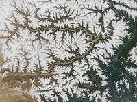
When leaving the Tibetan Plateau
, the Yarlung River flows in the world's largest and deepest canyon, Yarlung Zangbo Grand Canyon. The gorge has been described as "the highest river in the world" by the organizers of a kayaking expedition,
although it's not clear from their press release what definition was used.


 The Yarlung Zangbo River is the highest major river in the world. Its longest tributary is the Nyang River
. In Tibet the river flows through the South Tibet Valley, which is approximately 1200 kilometres long and 300 kilometres wide. The valley descends from 4500 metres above sea level to 3000 metres. As it descends, the surrounding vegetation changes from cold desert
to arid steppe
to deciduous scrub vegetation. It ultimately transitions into a conifer and rhododendron
forest. The tree line is approximately 3,200 metres. Sedimentary sandstone rocks
found near the Tibetan capital of Lhasa
contain grains of magnetic minerals that record the Earth's alternating magnetic field
current.
The basin of the Yarlung River, bounded by the Himalayas
in the south and the Gangdisê and Nyainqêntanglha Mountains in the north, has less severe climate than the more northern (and higher-elevation) parts of Tibet, and is home to most of the Autonomous Region
's population (Lhasa
City, Xigazê
, Lhoka, and Nyingchi
Prefectures).
The Yarlung Zangbo Grand Canyon, formed by a horse-shoe bend in the river where it leaves the Tibetan Plateau
and flows around Namcha Barwa
, is the deepest, and possibly longest canyon in the world. The river has been a challenge to whitewater kayakers because of the extreme conditions of the river.
The Yarlung Zangbo River has three major waterfalls. The largest waterfall of the river, the "Hidden Falls", was not publicized in the West until 1998, when its sighting by Westerners was briefly hailed as a "discovery." They were even portrayed as the discovery of the great falls which had been the topic of stories told to early Westerners by Tibetan hunters and Buddhist monks, but which had never been found by Western explorers at the time. Chinese authorities protested, however, saying that Chinese geographers, who had explored the gorge since 1973, had already taken pictures of the falls in 1987 from a helicopter.
Antonio Perezgrueso (undated). The Echo of Liquid Thunder. (span. original: Los ecos del trueno líquido) Explorations and Expeditions on the English pages of the Sociedad Geográfica Española (retrieved on 14 September 2008)
Who found it first? no longer existing website, quoted without further information on The Ancients. Shangri-La Found as: "Little attention was paid to the Chinese team that had been striking for the falls during that fateful trekking season. They claimed to have reached the falls before Baker but were ignored for the most part by everybody except their government who decided to close the gorge to westerners." (retrieved on 14 September 2008)
. The river has been called the “Everest of Rivers” because of the extreme conditions of the river. The first attempt to run was made in 1993 by a Japanese group who lost one member on the river.
In October 1998, a kayaking
expedition sponsored by the National Geographic Society
attempted to navigate the Zangbo Gorge. Troubled by unanticipated high water levels, the expedition ended in tragedy when expert kayaker Doug Gordon lost his life.
In January–February, 2002, an international group consisting of Scott Lindgren, Steve Fisher, Mike Abbott, Allan Ellard, Dustin Knapp, and Johnnie and Willie Kern, completed the first descent of the upper Zangbo gorge section.
Shangri La River Expeditions has a fairly complete description of the history of first descents of the Yarlong Tsangpo and its major tribuaries.
River
A river is a natural watercourse, usually freshwater, flowing towards an ocean, a lake, a sea, or another river. In a few cases, a river simply flows into the ground or dries up completely before reaching another body of water. Small rivers may also be called by several other names, including...
that originates upstream from the South Tibet Valley and Yarlung Zangbo Grand Canyon, in Tibet
Tibet
Tibet is a plateau region in Asia, north-east of the Himalayas. It is the traditional homeland of the Tibetan people as well as some other ethnic groups such as Monpas, Qiang, and Lhobas, and is now also inhabited by considerable numbers of Han and Hui people...
. It then passes through the state of Arunachal Pradesh
Arunachal Pradesh
Arunachal Pradesh is a state of India, located in the far northeast. It borders the states of Assam and Nagaland to the south, and shares international borders with Burma in the east, Bhutan in the west, and the People's Republic of China in the north. The majority of the territory is claimed by...
, India
India
India , officially the Republic of India , is a country in South Asia. It is the seventh-largest country by geographical area, the second-most populous country with over 1.2 billion people, and the most populous democracy in the world...
, where it is known as the Dihang.
It is called Yarlung Zangbo or Yarlung River , or Yalu Zangbu River , or Yarlung Tsangpo (alternative transcription), Yarlung Zangbo Jiang (officially). The suffix Zangbo
Tsangpo
Tsangpo is the suffix attached to names of rivers originating or sometimes flowing through the Tsang province of Tibet. Some of the rivers are:* The Yarlung Tsangpo – in its lower reaches it is known as the Brahmaputra River...
(or Tsangpo, Zangbu, etc.) denotes a river flowing from or through Tsang
Ü-Tsang
Ü-Tsang , or Tsang-Ü, is one of the three traditional provinces of Tibet, the other two being Amdo and Kham. Geographically Ü-Tsang covered the central and western portions of the Tibetan cultural area, including the Tsang-po watershed, the western districts surrounding and extending past Mount...
, i.e. Tibet west of Lhasa
Lhasa
Lhasa is the administrative capital of the Tibet Autonomous Region in the People's Republic of China and the second most populous city on the Tibetan Plateau, after Xining. At an altitude of , Lhasa is one of the highest cities in the world...
.
Downstream from Arunachal Pradesh
Arunachal Pradesh
Arunachal Pradesh is a state of India, located in the far northeast. It borders the states of Assam and Nagaland to the south, and shares international borders with Burma in the east, Bhutan in the west, and the People's Republic of China in the north. The majority of the territory is claimed by...
the river becomes wider and at this point is called the Brahmaputra River
Brahmaputra River
The Brahmaputra , also called Tsangpo-Brahmaputra, is a trans-boundary river and one of the major rivers of Asia. It is the only Indian river that is attributed the masculine gender and thus referred to as a in Indo-Aryan languages and languages with Indo-Aryan influence...
. From Assam
Assam
Assam , also, rarely, Assam Valley and formerly the Assam Province , is a northeastern state of India and is one of the most culturally and geographically distinct regions of the country...
(India) the river has entered Bangladesh
Bangladesh
Bangladesh , officially the People's Republic of Bangladesh is a sovereign state located in South Asia. It is bordered by India on all sides except for a small border with Burma to the far southeast and by the Bay of Bengal to the south...
at Ramnabazar point. From there till about 200 years ago it used to flow eastward and joined Megna River near Bhairavbazar. This old channel has been gradually dying now. At present the main channel of the river is called Jamuna River, which follows southward to meet Ganges known in Bangladesh as the Padma
Padma River
The Padma is a major trans-boundary river in Bangladesh. It is the main distributary of the Ganges , which originates in the Himalayas. The Padma enters Bangladesh from India near Chapai Nababganj...
.
When leaving the Tibetan Plateau
Tibetan Plateau
The Tibetan Plateau , also known as the Qinghai–Tibetan Plateau is a vast, elevated plateau in Central Asia covering most of the Tibet Autonomous Region and Qinghai, in addition to smaller portions of western Sichuan, southwestern Gansu, and northern Yunnan in Western China and Ladakh in...
, the Yarlung River flows in the world's largest and deepest canyon, Yarlung Zangbo Grand Canyon. The gorge has been described as "the highest river in the world" by the organizers of a kayaking expedition,
although it's not clear from their press release what definition was used.
Description
Nyang River
The Nyang River is a major river in south-west Tibet and the longest tributary of the Yarlung Tsangpo river....
. In Tibet the river flows through the South Tibet Valley, which is approximately 1200 kilometres long and 300 kilometres wide. The valley descends from 4500 metres above sea level to 3000 metres. As it descends, the surrounding vegetation changes from cold desert
Desert
A desert is a landscape or region that receives an extremely low amount of precipitation, less than enough to support growth of most plants. Most deserts have an average annual precipitation of less than...
to arid steppe
Steppe
In physical geography, steppe is an ecoregion, in the montane grasslands and shrublands and temperate grasslands, savannas, and shrublands biomes, characterized by grassland plains without trees apart from those near rivers and lakes...
to deciduous scrub vegetation. It ultimately transitions into a conifer and rhododendron
Rhododendron
Rhododendron is a genus of over 1 000 species of woody plants in the heath family, most with showy flowers...
forest. The tree line is approximately 3,200 metres. Sedimentary sandstone rocks
Sandstone
Sandstone is a sedimentary rock composed mainly of sand-sized minerals or rock grains.Most sandstone is composed of quartz and/or feldspar because these are the most common minerals in the Earth's crust. Like sand, sandstone may be any colour, but the most common colours are tan, brown, yellow,...
found near the Tibetan capital of Lhasa
Lhasa
Lhasa is the administrative capital of the Tibet Autonomous Region in the People's Republic of China and the second most populous city on the Tibetan Plateau, after Xining. At an altitude of , Lhasa is one of the highest cities in the world...
contain grains of magnetic minerals that record the Earth's alternating magnetic field
Magnetic field
A magnetic field is a mathematical description of the magnetic influence of electric currents and magnetic materials. The magnetic field at any given point is specified by both a direction and a magnitude ; as such it is a vector field.Technically, a magnetic field is a pseudo vector;...
current.
The basin of the Yarlung River, bounded by the Himalayas
Himalayas
The Himalaya Range or Himalaya Mountains Sanskrit: Devanagari: हिमालय, literally "abode of snow"), usually called the Himalayas or Himalaya for short, is a mountain range in Asia, separating the Indian subcontinent from the Tibetan Plateau...
in the south and the Gangdisê and Nyainqêntanglha Mountains in the north, has less severe climate than the more northern (and higher-elevation) parts of Tibet, and is home to most of the Autonomous Region
Tibet Autonomous Region
The Tibet Autonomous Region , Tibet or Xizang for short, also called the Xizang Autonomous Region is a province-level autonomous region of the People's Republic of China , created in 1965....
's population (Lhasa
Lhasa
Lhasa is the administrative capital of the Tibet Autonomous Region in the People's Republic of China and the second most populous city on the Tibetan Plateau, after Xining. At an altitude of , Lhasa is one of the highest cities in the world...
City, Xigazê
Xigazê Prefecture
Xigazê is a prefecture of Tibet Autonomous Region in China.The administrative center of the prefecture is the city of Shigatse ....
, Lhoka, and Nyingchi
Nyingchi Prefecture
Nyingchi Prefecture is a prefecture in southwestern Tibet Autonomous Region in western China. The Chinese government claims South Tibet, which is currently governed by India, as part of the prefecture....
Prefectures).
The Yarlung Zangbo Grand Canyon, formed by a horse-shoe bend in the river where it leaves the Tibetan Plateau
Tibetan Plateau
The Tibetan Plateau , also known as the Qinghai–Tibetan Plateau is a vast, elevated plateau in Central Asia covering most of the Tibet Autonomous Region and Qinghai, in addition to smaller portions of western Sichuan, southwestern Gansu, and northern Yunnan in Western China and Ladakh in...
and flows around Namcha Barwa
Namcha Barwa
Namjagbarwa Peak , also known as Namcha Barwa, Namchabarwa, or Nanjiabawa Feng, is a mountain in the Tibetan Himalaya. The traditional definition of the Himalaya extending from the Indus River to the Brahmaputra would make it the eastern anchor of the entire mountain chain, and it is the highest...
, is the deepest, and possibly longest canyon in the world. The river has been a challenge to whitewater kayakers because of the extreme conditions of the river.
The Yarlung Zangbo River has three major waterfalls. The largest waterfall of the river, the "Hidden Falls", was not publicized in the West until 1998, when its sighting by Westerners was briefly hailed as a "discovery." They were even portrayed as the discovery of the great falls which had been the topic of stories told to early Westerners by Tibetan hunters and Buddhist monks, but which had never been found by Western explorers at the time. Chinese authorities protested, however, saying that Chinese geographers, who had explored the gorge since 1973, had already taken pictures of the falls in 1987 from a helicopter.
Antonio Perezgrueso (undated). The Echo of Liquid Thunder. (span. original: Los ecos del trueno líquido) Explorations and Expeditions on the English pages of the Sociedad Geográfica Española (retrieved on 14 September 2008)
Who found it first? no longer existing website, quoted without further information on The Ancients. Shangri-La Found as: "Little attention was paid to the Chinese team that had been striking for the falls during that fateful trekking season. They claimed to have reached the falls before Baker but were ignored for the most part by everybody except their government who decided to close the gorge to westerners." (retrieved on 14 September 2008)
Kayak exploration
Since the 1990s the Yarlung Zangbo River has been the destination of a number of teams that engage in exploration and whitewater kayakingWhitewater kayaking
Whitewater kayaking is the sport of paddling a kayak on a moving body of water, typically a whitewater river. Whitewater kayaking can range from simple, carefree gently moving water, to demanding, dangerous whitewater. River rapids are graded like ski runs according to the difficulty, danger or...
. The river has been called the “Everest of Rivers” because of the extreme conditions of the river. The first attempt to run was made in 1993 by a Japanese group who lost one member on the river.
In October 1998, a kayaking
Kayaking
Kayaking is the use of a kayak for moving across water. Kayaking and canoeing are also known as paddling. Kayaking is distinguished from canoeing by the sitting position of the paddler and the number of blades on the paddle...
expedition sponsored by the National Geographic Society
National Geographic Society
The National Geographic Society , headquartered in Washington, D.C. in the United States, is one of the largest non-profit scientific and educational institutions in the world. Its interests include geography, archaeology and natural science, the promotion of environmental and historical...
attempted to navigate the Zangbo Gorge. Troubled by unanticipated high water levels, the expedition ended in tragedy when expert kayaker Doug Gordon lost his life.
In January–February, 2002, an international group consisting of Scott Lindgren, Steve Fisher, Mike Abbott, Allan Ellard, Dustin Knapp, and Johnnie and Willie Kern, completed the first descent of the upper Zangbo gorge section.
Shangri La River Expeditions has a fairly complete description of the history of first descents of the Yarlong Tsangpo and its major tribuaries.