
Salsette Island
Encyclopedia
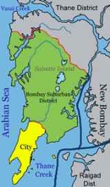
Salsette Island is an island
in Maharashtra
state on India
's west coast. The metropolis of Mumbai
(formerly Bombay) and the city of Thane
lie on this island, making it the 14th most populous island and the fourth most densely populated island in the world, after Migingo Island
in Kenya
, Ap Lei Chau
in Hong Kong
, China
and Malé Island in Maldives
.
, which were joined together during the 19th and early 20th centuries to form a single island. It is bounded on the north by Vasai Creek
, on the northeast by the Ulhas River
, on the east by Thane Creek
and Bombay Harbour, and on the south and west by the Arabian Sea
. The city of Mumbai lies on a peninsula on the southern end of the island, and Mumbai's suburbs cover much of the remainder of the island. The island contains Borivali National Park, also known as Sanjay Gandhi National Park. The city of Thane lies at the island's north-eastern corner, on Thane Creek. Politically, most of the island falls into the municipality of Mumbai. The municipality is divided into two separate districts
, Mumbai City and Mumbai Suburbs. The northern portion of the island lies within Thane District
, which extends across Vasai and Thane creeks onto the mainland.
, west Maharashtra
and who later were converted to the Roman Catholicism by the four preaching orders—Dominican
s, Franciscan
s, Augustinians and Jesuits who arrived in the 15th century along with the Portuguese. These original natives of Salsette island are the East Indian Catholics and Koli
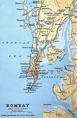
s. The Island city of Bombay was south of the Salsette Island and separated from it by the Mahim Creek
. These form the present City of Mumbai that were originally seven small islands
. The island of Trombay
lay to the southeast of Salsette though today much of the intervening swamps have been reclaimed as land.
109 Buddhist caves, including those at Kanheri, can be found on the island, and date from the end of the 2nd century. The island was ruled by a succession of Hindu kingdoms, the last of which to rule the islands were the Silharas
. In 1343 the islands were annexed by the Muslim
Sultanate of Gujarat. In 1534 the Portuguese
took the islands from Sultan Bahadur Shah of Gujarat
. Sashti was part of the northern province of Portuguese India
, which was governed from Baçaím (present-day Vasai) on the north shore of Vasai Creek. In 1661 the seven Bombay islets were ceded to Britain
as part of the dowry of Catherine of Bragança to King Charles II of England
. Sashti remained in Portuguese hands. King Charles in turn leased the Bombay islets to the British East India Company
in 1668 for £10 per year. The company found the deep harbour at Bombay eminently apposite, and the population rose from 10,000 in 1661 to 60,000 by 1675. In 1687, the East India Company transferred their headquarters there from Surat
.
In 1737 Sasashti was captured by the Maratha
s, and most of the Portuguese northern province was ceded to the Marathas in 1739. The British occupied Sashti in 1774, which was formally ceded to the East India Company in the 1782 Treaty of Salbai
.
In 1782 William Hornby, then Governor of Bombay Presidency
, initiated the project of connecting the isles. The Hornby Vellard
was the first of the engineering projects, started in 1784, despite opposition from the directors of the East India Company. The cost of the vellard was estimated at Rs.
100,000. The project gained momentum in 1817, and by 1845 the seven southern islands had been connected to form Old Bombay, with an area of 435 km². Railway viaducts and road bridges were built in the 19th century to connect Bombay island to Sashti, and Sashti to the mainland. These railway lines encouraged wealthier merchants to build villas on Sashti, and by 1901 the population of Sashti was 146,993, and became known as Greater Bombay. The channels separating Bombay and Trombay islands from Sashti Island were filled in the early 20th century.
 Parts of the island are hilly, although many of the hills were cut down and used to enlarge the island by filling in the shallows and to link the islands to one another. The highest point on the island is around 450 metres in the Borivali National Park, in the northern reaches of the island. This National Park
is the world's biggest within city limits.
prone, up to a magnitude of 6. The island is mostly composed of black basalt
rock. Since it is along the sea coast, it also has a sandy belt on its western coast. The southern region of Old Bombay is mostly at sea level. However, the parts which were erstwhile shallows are below sea level. Many parts of the city are hilly.
Also worth noticing is the occurrence of Laterite soil and rocks at a point on this island.
, Tulsi Lake
and Vihar Lake
. The latter two lakes supply part of the city's water requirements. Numerous other smaller ponds and lakes are also present in the Thane
region.
distributaries
of the Ulhas River
.
s, home to migratory birds. The northern, north western part of the island and parts of Mahim River also have government protected marshlands. These swampy regions form massive and dense mangrove
forests.
has numerous beaches. The best known is the Girgaum-Chowpatty Beach. Other well known beaches are Dadar Beach, Juhu Beach, Mahim Beach, Gorai Beach, Manori Beach and Worli Beach; of which Juhu, Manori and Gorai Beaches lies on west coast of Sashti (साष्टी) island.
Island
An island or isle is any piece of sub-continental land that is surrounded by water. Very small islands such as emergent land features on atolls can be called islets, cays or keys. An island in a river or lake may be called an eyot , or holm...
in Maharashtra
Maharashtra
Maharashtra is a state located in India. It is the second most populous after Uttar Pradesh and third largest state by area in India...
state on India
India
India , officially the Republic of India , is a country in South Asia. It is the seventh-largest country by geographical area, the second-most populous country with over 1.2 billion people, and the most populous democracy in the world...
's west coast. The metropolis of Mumbai
Mumbai
Mumbai , formerly known as Bombay in English, is the capital of the Indian state of Maharashtra. It is the most populous city in India, and the fourth most populous city in the world, with a total metropolitan area population of approximately 20.5 million...
(formerly Bombay) and the city of Thane
Thane
Thane , is a city in Maharashtra, India, part of the Mumbai Metropolitan Region, northeastern suburb of Mumbai at the head of the Thane Creek. It is the administrative headquarters of Thane district. On 16 April 1853, G.I.P...
lie on this island, making it the 14th most populous island and the fourth most densely populated island in the world, after Migingo Island
Migingo Island
Migingo is a tiny 2,000-square-metre island, about half the size of a football pitch in Lake Victoria.In 2008–09 the island itself was claimed by both Kenya and Uganda. July 2009 a survey team found that the island is east of the Kenya-Uganda border within the lake, a finding supported by...
in Kenya
Kenya
Kenya , officially known as the Republic of Kenya, is a country in East Africa that lies on the equator, with the Indian Ocean to its south-east...
, Ap Lei Chau
Ap Lei Chau
Ap Lei Chau , or Aberdeen Island, is an island of Hong Kong, located south-west of Hong Kong Island, next to Aberdeen Harbour and Aberdeen Channel, with an area of 1.30 km². Administratively, it is part of Southern District. Ap Lei Chau is the third most densely populated island in the world.-...
in Hong Kong
Hong Kong
Hong Kong is one of two Special Administrative Regions of the People's Republic of China , the other being Macau. A city-state situated on China's south coast and enclosed by the Pearl River Delta and South China Sea, it is renowned for its expansive skyline and deep natural harbour...
, China
China
Chinese civilization may refer to:* China for more general discussion of the country.* Chinese culture* Greater China, the transnational community of ethnic Chinese.* History of China* Sinosphere, the area historically affected by Chinese culture...
and Malé Island in Maldives
Maldives
The Maldives , , officially Republic of Maldives , also referred to as the Maldive Islands, is an island nation in the Indian Ocean formed by a double chain of twenty-six atolls oriented north-south off India's Lakshadweep islands, between Minicoy Island and...
.
Location
The present island was formerly made up of several smaller islandsSeven islands of Bombay
The seven islands of Bombay were an archipelago of islands that were, over a span of five centuries, connected to form the area of the modern city of Mumbai in India. The seven islands were gradually physically united through land reclamation projects...
, which were joined together during the 19th and early 20th centuries to form a single island. It is bounded on the north by Vasai Creek
Vasai Creek
Vasai Creek is an estuarine creek, one of the two main distributaries of the Ulhas River in Maharashtra state of western India. The Ulhas splits at the northeast corner of Salsette Island into its two main distributaries, Vasai Creek and Thane Creek...
, on the northeast by the Ulhas River
Ulhas River
The Ulhas River is a river of western India. It originates near Karjat in the Western Ghats Range, and flows westward through Raigad and Thane districts of Maharashtra between Kulgaon-Badlapur, north to Ulhasnagar and on to Kalyan, where it turns west to Thane...
, on the east by Thane Creek
Thane Creek
Thane Creek is part of the estuary of the Ulhas River in western India opening into Mumbai Harbour. It comprises the area stretching from Mumbra Retibunder to the Mankhurd-Vashi Bridge. It has been recognised as an Important Bird Area by the Bombay Natural History Society, as it is home to...
and Bombay Harbour, and on the south and west by the Arabian Sea
Arabian Sea
The Arabian Sea is a region of the Indian Ocean bounded on the east by India, on the north by Pakistan and Iran, on the west by the Arabian Peninsula, on the south, approximately, by a line between Cape Guardafui in northeastern Somalia and Kanyakumari in India...
. The city of Mumbai lies on a peninsula on the southern end of the island, and Mumbai's suburbs cover much of the remainder of the island. The island contains Borivali National Park, also known as Sanjay Gandhi National Park. The city of Thane lies at the island's north-eastern corner, on Thane Creek. Politically, most of the island falls into the municipality of Mumbai. The municipality is divided into two separate districts
Districts of Maharashtra
The Indian state of Maharashtra came into existence on May 1, 1960 , initially with 28 districts. 7 new districts have been created since then and currently the number of districts in the state is 35...
, Mumbai City and Mumbai Suburbs. The northern portion of the island lies within Thane District
Thane District
Thane is a district in northern Maharashtra state in western India. As of 2011 it is the most populated district in the nation. The headquarters of the district is the city of Thane. Other major cities in the district are Navi Mumbai , Kalyan-Dombivli, Mira-Bhayander, Bhiwandi, Ulhasnagar,...
, which extends across Vasai and Thane creeks onto the mainland.
History
The name Sasashti (also shortened to Sashti) means "sixty-six villages" was inhabited by farmers, agriculturalists, toddy tappers, artisans, fisherfolks who trace their conversion to Christianity back to 55 AD with the arrival of Christ’s disciple St. Bartholomew in North KonkanKonkan
The Konkan also called the Konkan Coast or Karavali is a rugged section of the western coastline of India from Raigad to Mangalore...
, west Maharashtra
Maharashtra
Maharashtra is a state located in India. It is the second most populous after Uttar Pradesh and third largest state by area in India...
and who later were converted to the Roman Catholicism by the four preaching orders—Dominican
Dominican Order
The Order of Preachers , after the 15th century more commonly known as the Dominican Order or Dominicans, is a Catholic religious order founded by Saint Dominic and approved by Pope Honorius III on 22 December 1216 in France...
s, Franciscan
Franciscan
Most Franciscans are members of Roman Catholic religious orders founded by Saint Francis of Assisi. Besides Roman Catholic communities, there are also Old Catholic, Anglican, Lutheran, ecumenical and Non-denominational Franciscan communities....
s, Augustinians and Jesuits who arrived in the 15th century along with the Portuguese. These original natives of Salsette island are the East Indian Catholics and Koli
KOLI
KOLI is a radio station serving Wichita Falls, Texas and Vicinity with a country music format. It operates on FM frequency 94.9 MHz and is under ownership of Cumulus Media. It is the radio flagship station for the Wichita Falls Wildcats hockey team....
s. The Island city of Bombay was south of the Salsette Island and separated from it by the Mahim Creek
Mahim Creek
Mahim Creek is a creek in Mumbai, India. The Mithi River drains into the creek which drains into the Mahim Bay. The creek forms the boundary between the city and suburbs...
. These form the present City of Mumbai that were originally seven small islands
Seven islands of Bombay
The seven islands of Bombay were an archipelago of islands that were, over a span of five centuries, connected to form the area of the modern city of Mumbai in India. The seven islands were gradually physically united through land reclamation projects...
. The island of Trombay
Trombay
Trombay is a northeastern suburb in Mumbai, India, with Mankhurd as the closest railway station on the Harbour Line of the Mumbai Suburban Railway.-History:...
lay to the southeast of Salsette though today much of the intervening swamps have been reclaimed as land.
109 Buddhist caves, including those at Kanheri, can be found on the island, and date from the end of the 2nd century. The island was ruled by a succession of Hindu kingdoms, the last of which to rule the islands were the Silharas
Silhara dynasty
The Hindu Silhara dynasty ruled the region around present-day Mumbai between 810 and 1240.They were split into three branches; one branch ruled North Konkan, the second South Konkan , while the third ruled what is now known as modern districts of Satara, Kolhapur and Belgaon between 940 to 1215...
. In 1343 the islands were annexed by the Muslim
Muslim
A Muslim, also spelled Moslem, is an adherent of Islam, a monotheistic, Abrahamic religion based on the Quran, which Muslims consider the verbatim word of God as revealed to prophet Muhammad. "Muslim" is the Arabic term for "submitter" .Muslims believe that God is one and incomparable...
Sultanate of Gujarat. In 1534 the Portuguese
Portugal
Portugal , officially the Portuguese Republic is a country situated in southwestern Europe on the Iberian Peninsula. Portugal is the westernmost country of Europe, and is bordered by the Atlantic Ocean to the West and South and by Spain to the North and East. The Atlantic archipelagos of the...
took the islands from Sultan Bahadur Shah of Gujarat
Bahadur Shah of Gujarat
Sultan Qutb-ud-Din Bahadur Shah , who reigned 1526-1535 and 1536-1537, was a sultan of Gujarat Sultanate, a late medieval independent kingdom in India.-Early years:...
. Sashti was part of the northern province of Portuguese India
Portuguese India
The Portuguese Viceroyalty of India , later the Portuguese State of India , was the aggregate of Portugal's colonial holdings in India.The government started in 1505, six years after the discovery of a sea route to India by Vasco da Gama, with the nomination of the first Viceroy Francisco de...
, which was governed from Baçaím (present-day Vasai) on the north shore of Vasai Creek. In 1661 the seven Bombay islets were ceded to Britain
United Kingdom
The United Kingdom of Great Britain and Northern IrelandIn the United Kingdom and Dependencies, other languages have been officially recognised as legitimate autochthonous languages under the European Charter for Regional or Minority Languages...
as part of the dowry of Catherine of Bragança to King Charles II of England
Charles II of England
Charles II was monarch of the three kingdoms of England, Scotland, and Ireland.Charles II's father, King Charles I, was executed at Whitehall on 30 January 1649, at the climax of the English Civil War...
. Sashti remained in Portuguese hands. King Charles in turn leased the Bombay islets to the British East India Company
British East India Company
The East India Company was an early English joint-stock company that was formed initially for pursuing trade with the East Indies, but that ended up trading mainly with the Indian subcontinent and China...
in 1668 for £10 per year. The company found the deep harbour at Bombay eminently apposite, and the population rose from 10,000 in 1661 to 60,000 by 1675. In 1687, the East India Company transferred their headquarters there from Surat
Surat
Surat , also known as Suryapur, is the commercial capital city of the Indian state of Gujarat. Surat is India's Eighth most populous city and Ninth-most populous urban agglomeration. It is also administrative capital of Surat district and one of the fastest growing cities in India. The city proper...
.
In 1737 Sasashti was captured by the Maratha
Maratha
The Maratha are an Indian caste, predominantly in the state of Maharashtra. The term Marāthā has three related usages: within the Marathi speaking region it describes the dominant Maratha caste; outside Maharashtra it can refer to the entire regional population of Marathi-speaking people;...
s, and most of the Portuguese northern province was ceded to the Marathas in 1739. The British occupied Sashti in 1774, which was formally ceded to the East India Company in the 1782 Treaty of Salbai
Treaty of Salbai
The Treaty of Salbai was signed on May 17, 1782, by representatives of the Maratha Empire and the British East India Company after long negotiations to settle the outcome of the First Anglo-Maratha War. Under its terms, the Company retained control of Salsette and acquired guarantees that the...
.
In 1782 William Hornby, then Governor of Bombay Presidency
Bombay Presidency
The Bombay Presidency was a province of British India. It was established in the 17th century as a trading post for the English East India Company, but later grew to encompass much of western and central India, as well as parts of post-partition Pakistan and the Arabian Peninsula.At its greatest...
, initiated the project of connecting the isles. The Hornby Vellard
Hornby Vellard
The Hornby Vellard was a project to build a causeway uniting all seven islands of Bombay into a single island with a deep natural harbour. The project was started by the governor William Hornby in 1782 and all islands were linked by 1838...
was the first of the engineering projects, started in 1784, despite opposition from the directors of the East India Company. The cost of the vellard was estimated at Rs.
Rupee
The rupee is the common name for the monetary unit of account in India, Sri Lanka, Nepal, Pakistan, Mauritius, Seychelles, Maldives, and formerly in Burma, and Afghanistan. Historically, the first currency called "rupee" was introduced in the 16th century...
100,000. The project gained momentum in 1817, and by 1845 the seven southern islands had been connected to form Old Bombay, with an area of 435 km². Railway viaducts and road bridges were built in the 19th century to connect Bombay island to Sashti, and Sashti to the mainland. These railway lines encouraged wealthier merchants to build villas on Sashti, and by 1901 the population of Sashti was 146,993, and became known as Greater Bombay. The channels separating Bombay and Trombay islands from Sashti Island were filled in the early 20th century.
Geography
National park
A national park is a reserve of natural, semi-natural, or developed land that a sovereign state declares or owns. Although individual nations designate their own national parks differently A national park is a reserve of natural, semi-natural, or developed land that a sovereign state declares or...
is the world's biggest within city limits.
Geology
The island is located at the confluence of a number of fault lines. This makes the area earthquakeEarthquake
An earthquake is the result of a sudden release of energy in the Earth's crust that creates seismic waves. The seismicity, seismism or seismic activity of an area refers to the frequency, type and size of earthquakes experienced over a period of time...
prone, up to a magnitude of 6. The island is mostly composed of black basalt
Basalt
Basalt is a common extrusive volcanic rock. It is usually grey to black and fine-grained due to rapid cooling of lava at the surface of a planet. It may be porphyritic containing larger crystals in a fine matrix, or vesicular, or frothy scoria. Unweathered basalt is black or grey...
rock. Since it is along the sea coast, it also has a sandy belt on its western coast. The southern region of Old Bombay is mostly at sea level. However, the parts which were erstwhile shallows are below sea level. Many parts of the city are hilly.
Also worth noticing is the occurrence of Laterite soil and rocks at a point on this island.
Lakes
There are three major lakes on the island Powai LakePowai Lake
Powai Lake is an artificial lake, situated in the northern suburb of Mumbai, in the Powai valley, where a Powai village with cluster of huts existed...
, Tulsi Lake
Tulsi Lake
Tulsi Lake is a fresh water lake in northern Mumbai. It is stated to be the second largest lake in Mumbai and supplies part of the city’s potable water.http://mumbai.clickindia.com/travel/tulsilake.html, Travel, Tulsi lake This is one of the three lakes located in the Salsette Island; the other two...
and Vihar Lake
Vihar Lake
Vihar Lake is located near Vihar village on the Mithi River within the precincts of the Borivali National Park, also called the Sanjay Gandhi National Park, in North Mumbai. When built in 1860 , it was considered as the largest lake in Mumbai in the Salsette group of islands. It is hemmed between...
. The latter two lakes supply part of the city's water requirements. Numerous other smaller ponds and lakes are also present in the Thane
Thane
Thane , is a city in Maharashtra, India, part of the Mumbai Metropolitan Region, northeastern suburb of Mumbai at the head of the Thane Creek. It is the administrative headquarters of Thane district. On 16 April 1853, G.I.P...
region.
Rivers
Three small rivers, the Mithi (Mahim), Oshiwara and Dahisar, originate within the National Park, and empty into the Arabian Sea. The Mithi River originates from the Powai Lake. Vasai and Thane creeks are estuarineEstuary
An estuary is a partly enclosed coastal body of water with one or more rivers or streams flowing into it, and with a free connection to the open sea....
distributaries
Distributary
A distributary, or a distributary channel, is a stream that branches off and flows away from a main stream channel. They are a common feature of river deltas. The phenomenon is known as river bifurcation. The opposite of a distributary is a tributary...
of the Ulhas River
Ulhas River
The Ulhas River is a river of western India. It originates near Karjat in the Western Ghats Range, and flows westward through Raigad and Thane districts of Maharashtra between Kulgaon-Badlapur, north to Ulhasnagar and on to Kalyan, where it turns west to Thane...
.
Creeks
A number of saline or brackish creeks extend inland from the coastline. The Mahim creek separates the city from the suburbs in the west, and the Sion Creek in the east (Sion creek no longer exists). Further north on the western coast, the Oshiwara river empties into the Malad (or Marvé) Creek and the Dahisar River into the Gorai Creek. The eastern waterfront too, has many small creeks.Wetlands
The small southern part of the eastern waterfront of the island forms the Bombay harbour. North of this region lie vast amounts of protected wetlandWetland
A wetland is an area of land whose soil is saturated with water either permanently or seasonally. Wetlands are categorised by their characteristic vegetation, which is adapted to these unique soil conditions....
s, home to migratory birds. The northern, north western part of the island and parts of Mahim River also have government protected marshlands. These swampy regions form massive and dense mangrove
Mangrove
Mangroves are various kinds of trees up to medium height and shrubs that grow in saline coastal sediment habitats in the tropics and subtropics – mainly between latitudes N and S...
forests.
Beaches
The western coast of MumbaiMumbai
Mumbai , formerly known as Bombay in English, is the capital of the Indian state of Maharashtra. It is the most populous city in India, and the fourth most populous city in the world, with a total metropolitan area population of approximately 20.5 million...
has numerous beaches. The best known is the Girgaum-Chowpatty Beach. Other well known beaches are Dadar Beach, Juhu Beach, Mahim Beach, Gorai Beach, Manori Beach and Worli Beach; of which Juhu, Manori and Gorai Beaches lies on west coast of Sashti (साष्टी) island.