

Aksai Chin
Encyclopedia
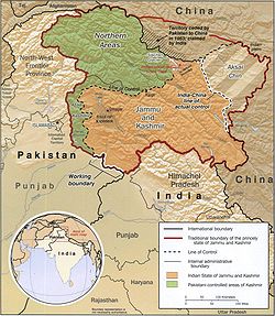
Aksai Chin is one of the two main disputed border areas between China
and India
, and the other is South Tibet
, which comprises most of India's Arunachal Pradesh
. It is administered by China as part of Hotan County in the Hotan Prefecture of Xinjiang Autonomous Region, but is also claimed by India as a part of the Ladakh
district of the state of Jammu and Kashmir
. In 1962 China and India fought a brief war
over Aksai Chin and South Tibet, but in 1993 and 1996 the two countries signed agreements to respect the Line of Actual Control
.
including some salt lakes from 4800 metres (15,748 ft) to 5500 metres (18,044.6 ft) above sea level. It covers an area of 37244 square kilometres (14,380 sq mi). The Chinese name of the region, 阿克赛钦, is composed of Chinese characters chosen for their phonetic values, irrespective of their meaning.
from Aksai Chin is known as the Line of Actual Control
(LAC) and is concurrent with the Chinese Aksai Chin claim line.
Topographically, Aksai Chin is a high altitude desert. In the southwest, the Karakoram
range form the de facto border (Line of Actual Control) between Aksai Chin and Indian-controlled Kashmir. Glaciated peaks in the mid portion of this boundary reach heights of 6950 metres (22,801.8 ft).
In the north, the Kunlun Range
separates Aksai Chin from the Tarim Basin
, where the rest of Hotan County is situated. According to a recent detailed Chinese map, no roads cross the Kunlun Range within Hotan Prefecture, and only one track does so, over the Hindutash
Pass.
The northern part of Aksai Chin is referred to as the Soda Plain and contains Aksai Chin's largest river, the Karakosh
, The river, which receives meltwater from a number of glaciers, crosses the Kunlun farther northwest, in Pishan County
and enters the Tarim Basin, where it serves as one of the main sources of water for Karakax and Hotan Counties.
The eastern part of the region contains several small endorheic
basins. The largest of them is that of the Aksai Chin Lake
, which is fed by the river of the same name.
The region is almost uninhabited, has no permanent settlements, and receives little precipitation as the Himalayas
and the Karakoram block the rains from the Indian monsoon
.
At an elevation of 5,000m, the desolation of Aksai Chin had no human importance other than an ancient trade route that crossed over it, providing a brief pass during summer for caravans of yaks between Xinjiang and Tibet.
One of the earliest treaties regarding the boundaries in the western sector was issued in 1842. The Sikh Confederacy
of the Punjab region
in India had annexed Ladakh
into the state of Jammu
in 1834. In 1841, they invaded Tibet with an army. Chinese forces defeated the Sikh army and in turn entered Ladakh and besieged Leh. After being checked by the Sikh forces, the Chinese and the Sikhs signed a treaty in September 1842, which stipulated no transgressions or interference in the other country's frontiers. The British defeat of the Sikhs in 1846
resulted in transfer of sovereignty over Ladakh to the British, and British commissioners attempted to meet with Chinese officials to discuss the border they now shared. However, both sides were apparently sufficiently satisfied that a traditional border was recognized and defined by natural delements, and the border was not demarcated. The boundaries at the two extremities, Pangong Lake and Karakoram Pass
, were well-defined, but the Aksai Chin area in between lay undefined.
 W. H. Johnson, a civil servant with the Survey of India
proposed the "Johnson Line" in 1865, which put Aksai Chin in Kashmir. This was the time of the Dungan revolt, when China did not control Xinjiang
, so this line was never presented to the Chinese. Johnson presented this line to the Maharaja of Kashmir, who then claimed the 18,000 square kilometres contained within, and by some accounts territory further north as far as the Sanju Pass
in the Kun Lun Mountains. Johnson's work was severely criticized for gross inaccuracies, with description of his boundary as "patently absurd". Johnson was reprimanded by the British Government and resigned from the Survey. The Maharajah of Kashmir apparently sent a few soldiers to man the abandoned fort at Shahidulla (modern-day Xaidulla
) at one point, by the time most sources placed Shahidulla and the upper Karakash River
firmly within the territory of Xinjiang (see accompanying map). According to Francis Younghusband
, who explored the region in the late 1880s, there was only an abandoned fort and not one inhabited house at Shahidulla when he was there - it was just a convenient staging post and a convenient headquarters for the nomadic Kirghiz. The abandoned fort had apparently been built a few years earlier by the Kashmiris. In 1878 the Chinese had reconquered Xinjiang, and by 1890 they already had Shahidulla before the issue was decided. By 1892, China had erected boundary markers at Karakoram Pass
.
In 1897 a British military officer, Sir John Ardagh, proposed a boundary line along the crest of the Kun Lun Mountains north of the Yarkand River
. At the time Britain was concerned at the danger of Russian expansion as China weakened, and Ardagh argued that his line was more defensible. The Ardagh line was effectively a modification of the Johnson line, and became known as the "Johnson-Ardagh Line".
n hands. In 1899, when China showed an interest in Aksai Chin, Britain proposed a revised boundary, initially suggested by George Macartney, which put most of Aksai Chin in Chinese territory. This border, along the Karakoram Mountains, was proposed and supported by British officials for a number of reasons. The Karakoram Mountains formed a natural boundary, which would set the British borders up to the Indus River
watershed
while leaving the Tarim River
watershed in Chinese control, and Chinese control of this tract would present a further obstacle to Russian advance in Central Asia. The British presented this line to the Chinese in a Note by Sir Claude MacDonald. The Chinese did not respond to the Note, and the British took that as Chinese acquiescence. This line, known as the Macartney-MacDonald line, is approximately the same as the current Line of Actual Control.
resulted in the collapse of central power in China, and by the end of World War I
, the British officially used the Johnson Line. However they took no steps to establish outposts or assert actual control on the ground. In 1927, the line was adjusted again as the government of British India abandoned the Johnson line in favor of a line along the Karakoram range further south. However, the maps were not updated and still showed the Johnson Line.
When British officials learned of Soviet officials surveying the Aksai Chin for Sheng Shicai
, warlord of Xinjiang
in 1940-1941, they again advocated the Johnson Line. At this point the British had still made no attempts to establish outposts or control over the Aksai Chin, nor was the issue ever discussed with the governments of China or Tibet, and the boundary remained undemarcated at India's independence.
, and incorporating part of the Karakash River
and Yarkand River
watersheds. From there, it runs east along the Kunlun Mountains, before turning southwest through the Aksai Chin salt flats, through the Karakoram Mountains, and then to Panggong Lake.
On July 1, 1954 Prime Minister Jawaharlal Nehru
wrote a memo directing that the maps of India be revised to show definite boundaries on all frontiers. Up to this point, the boundary in the Aksai Chin
sector, based on the Johnson Line, had been described as "undemarcated."
During the 1950s, the People's Republic of China
built a 1,200 km (750 mi) road connecting Xinjiang and western Tibet
, of which 179 km (112 mi) ran south of the Johnson Line through the Aksai Chin region claimed by India. Aksai Chin was easily accessible to the Chinese, but was more difficult for the Indians on the other side of the Karakorams to reach. The Indians did not learn of the existence of the road until 1957, which was confirmed when the road was shown in Chinese maps published in 1958.
The Indian position, as stated by Prime Minister Nehru, was that the Aksai Chin was "part of the Ladakh region of India for centuries" and that this northern border was a "firm and definite one which was not open to discussion with anybody".
The Chinese minister Zhou Enlai
argued that the western border had never been delimited, that the Macartney-MacDonald Line, which left the Aksai Chin within Chinese borders was the only line ever proposed to a Chinese government, and that the Aksai Chin was already under Chinese jurisdiction, and that negotiations should take into account the status quo.
, where China adjoins Pakistan-administered Gilgit-Baltistan. On October 13, 1962, China and Pakistan began negotiations over the boundary west of the Karakoram Pass. In 1963, the two countries settled their boundaries largely on the basis of the Macartney-MacDonald Line, which left the Trans Karakoram Tract in China, although the agreement provided for renegotiation in the event of a settlement of the Kashmir dispute. India does not recognise that Pakistan and China have a common border, and claims the tract as part of the domains of the pre-1947 state of Kashmir and Jammu. However, India's claim line in that area does not extend as far north of the Karakoram Mountains as the Johnson Line
runs through Aksai Chin connecting Lazi
and Xinjiang
in the Tibet Autonomous Region
. Despite this region being nearly uninhabitable and having no resources, it remains strategically important for China as it connects Tibet and Xinjiang. Construction started in 1951 and the road was completed in 1957. The construction of this highway was one of the triggers for the Sino-Indian War
of 1962.
on the Google Earth
service revealed a 1:500 scale terrain model http://maps.google.com/maps?f=q&hl=en&q=yinchuan,+china&ie=UTF8&t=k&om=1&ll=38.26568,105.953865&spn=0.014489,0.042915 of eastern Aksai Chin and adjacent Tibet, built near the town of Huangyangtan, about 35 kilometres (21.7 mi) southwest of Yinchuan, the capital of the autonomous region of Ningxia
in China. A visual side-by-side comparison shows a very detailed duplication of Aksai Chin in the camp. The 900 metre model was surrounded by a substantial facility, with rows of red-roofed buildings, scores of olive-colored trucks and a large compound with elevated lookout posts and a large communications tower. Such terrain models are known to be used in military training and simulation, although usually on a much smaller scale.
Local authorities in Ningxia point out that their model of Aksai Chin is part of a tank training ground, built in 1998 or 1999.
China
Chinese civilization may refer to:* China for more general discussion of the country.* Chinese culture* Greater China, the transnational community of ethnic Chinese.* History of China* Sinosphere, the area historically affected by Chinese culture...
and India
India
India , officially the Republic of India , is a country in South Asia. It is the seventh-largest country by geographical area, the second-most populous country with over 1.2 billion people, and the most populous democracy in the world...
, and the other is South Tibet
South Tibet
The Arunachal Pradesh dispute is a territorial dispute over the region located on the middle of the Yarlung Zangbo River, 300 km north of the Himalayas. It is entirely administered by India as part of its Arunachal Pradesh state; China claims it as a part of its Tibet Autonomous Region and...
, which comprises most of India's Arunachal Pradesh
Arunachal Pradesh
Arunachal Pradesh is a state of India, located in the far northeast. It borders the states of Assam and Nagaland to the south, and shares international borders with Burma in the east, Bhutan in the west, and the People's Republic of China in the north. The majority of the territory is claimed by...
. It is administered by China as part of Hotan County in the Hotan Prefecture of Xinjiang Autonomous Region, but is also claimed by India as a part of the Ladakh
Ladakh
Ladakh is a region of Jammu and Kashmir, the northernmost state of the Republic of India. It lies between the Kunlun mountain range in the north and the main Great Himalayas to the south, inhabited by people of Indo-Aryan and Tibetan descent...
district of the state of Jammu and Kashmir
Jammu and Kashmir
Jammu and Kashmir is the northernmost state of India. It is situated mostly in the Himalayan mountains. Jammu and Kashmir shares a border with the states of Himachal Pradesh and Punjab to the south and internationally with the People's Republic of China to the north and east and the...
. In 1962 China and India fought a brief war
Sino-Indian War
The Sino-Indian War , also known as the Sino-Indian Border Conflict , was a war between China and India that occurred in 1962. A disputed Himalayan border was the main pretext for war, but other issues played a role. There had been a series of violent border incidents after the 1959 Tibetan...
over Aksai Chin and South Tibet, but in 1993 and 1996 the two countries signed agreements to respect the Line of Actual Control
Line of Actual Control
The Line of Actual Control is the effective border between India and People's Republic of China . The LAC is 4,057-km long and traverses three areas of northern Indian states: western , middle and eastern...
.
Name
The etymology of Aksai Chin is uncertain regarding the word "Chin". As a word of Turk origin, aksai literally means "white brook" but whether the word Chin refers to Chinese or pass is disputed. The area is largely a vast high-altitude desertDesert
A desert is a landscape or region that receives an extremely low amount of precipitation, less than enough to support growth of most plants. Most deserts have an average annual precipitation of less than...
including some salt lakes from 4800 metres (15,748 ft) to 5500 metres (18,044.6 ft) above sea level. It covers an area of 37244 square kilometres (14,380 sq mi). The Chinese name of the region, 阿克赛钦, is composed of Chinese characters chosen for their phonetic values, irrespective of their meaning.
Geography
Aksai Chin is one of the two main disputed border areas between India and China. India claims Aksai Chin as the eastern-most part of the Jammu and Kashmir state. The line that separates Indian-administered areas of Jammu and KashmirJammu and Kashmir
Jammu and Kashmir is the northernmost state of India. It is situated mostly in the Himalayan mountains. Jammu and Kashmir shares a border with the states of Himachal Pradesh and Punjab to the south and internationally with the People's Republic of China to the north and east and the...
from Aksai Chin is known as the Line of Actual Control
Line of Actual Control
The Line of Actual Control is the effective border between India and People's Republic of China . The LAC is 4,057-km long and traverses three areas of northern Indian states: western , middle and eastern...
(LAC) and is concurrent with the Chinese Aksai Chin claim line.
Topographically, Aksai Chin is a high altitude desert. In the southwest, the Karakoram
Karakoram
The Karakoram, or Karakorum , is a large mountain range spanning the borders between Pakistan, India and China, located in the regions of Gilgit-Baltistan , Ladakh , and Xinjiang region,...
range form the de facto border (Line of Actual Control) between Aksai Chin and Indian-controlled Kashmir. Glaciated peaks in the mid portion of this boundary reach heights of 6950 metres (22,801.8 ft).
In the north, the Kunlun Range
Kunlun Mountains
The Kunlun Mountains are one of the longest mountain chains in Asia, extending more than 3,000 km. In the broadest sense, it forms the northern edge of the Tibetan Plateau south of the Tarim Basin and the Gansu Corridor and continues east south of the Wei River to end at the North China Plain.The...
separates Aksai Chin from the Tarim Basin
Tarim Basin
The Tarim Basin is a large endorheic basin occupying an area of about . It is located in the Xinjiang Uyghur Autonomous Region in China's far west. Its northern boundary is the Tian Shan mountain range and its southern is the Kunlun Mountains on the northern edge of the Tibetan Plateau. The...
, where the rest of Hotan County is situated. According to a recent detailed Chinese map, no roads cross the Kunlun Range within Hotan Prefecture, and only one track does so, over the Hindutash
Hindutash
Hindutash, also known as Hindu-tagh Pass, is a historical mountain pass in the western Xinjiang Uyghur Autonomous Region of the People's Republic of China...
Pass.
The northern part of Aksai Chin is referred to as the Soda Plain and contains Aksai Chin's largest river, the Karakosh
Karakash River
The Karakash or Black Jade River, also spelled Karakax , is a river in the Xinjiang autonomous region of the People's Republic of China, which lies partially in the disputed Aksai Chin region. The river originates near Sumde on the northern slopes of the Karakoram range in the Aksai Chin region of...
, The river, which receives meltwater from a number of glaciers, crosses the Kunlun farther northwest, in Pishan County
Pishan County
The Pishan County is a county within the Xinjiang Uyghur Autonomous Region and is under the administration of the Khotan Prefecture. It contains an area of 39,412 km2. According to the 2002 census, it has a population of 220,000....
and enters the Tarim Basin, where it serves as one of the main sources of water for Karakax and Hotan Counties.
The eastern part of the region contains several small endorheic
Endorheic
An endorheic basin is a closed drainage basin that retains water and allows no outflow to other bodies of water such as rivers or oceans...
basins. The largest of them is that of the Aksai Chin Lake
Aksai Chin Lake
Aksai Chin Lake is an endorheic lake on the Aksai Chin Plateau. The plateau is considered by China as part of its national territory and is administered as part of Hotan County, Xinjiang, but is also claimed by India....
, which is fed by the river of the same name.
The region is almost uninhabited, has no permanent settlements, and receives little precipitation as the Himalayas
Himalayas
The Himalaya Range or Himalaya Mountains Sanskrit: Devanagari: हिमालय, literally "abode of snow"), usually called the Himalayas or Himalaya for short, is a mountain range in Asia, separating the Indian subcontinent from the Tibetan Plateau...
and the Karakoram block the rains from the Indian monsoon
Monsoon
Monsoon is traditionally defined as a seasonal reversing wind accompanied by corresponding changes in precipitation, but is now used to describe seasonal changes in atmospheric circulation and precipitation associated with the asymmetric heating of land and sea...
.
History
At an elevation of 5,000m, the desolation of Aksai Chin had no human importance other than an ancient trade route that crossed over it, providing a brief pass during summer for caravans of yaks between Xinjiang and Tibet.
One of the earliest treaties regarding the boundaries in the western sector was issued in 1842. The Sikh Confederacy
Sikh Confederacy
The Sikh Empire was an imperial power from the Indian Subcontinent. The empire, based around the Punjab region, existed from 1799 to 1849. It was forged, on the foundations of the Khalsa, under the leadership of Maharaja Ranjit Singh from a collection of autonomous Punjabi Misls...
of the Punjab region
Punjab region
The Punjab , also spelled Panjab |water]]s"), is a geographical region straddling the border between Pakistan and India which includes Punjab province in Pakistan and the states of the Punjab, Haryana, Himachal Pradesh, Chandigarh and some northern parts of the National Capital Territory of Delhi...
in India had annexed Ladakh
Ladakh
Ladakh is a region of Jammu and Kashmir, the northernmost state of the Republic of India. It lies between the Kunlun mountain range in the north and the main Great Himalayas to the south, inhabited by people of Indo-Aryan and Tibetan descent...
into the state of Jammu
Jammu
Jammu , also known as Duggar, is one of the three administrative divisions within Jammu and Kashmir, the northernmost state in India.Jammu city is the largest city in Jammu and the winter capital of Jammu and Kashmir...
in 1834. In 1841, they invaded Tibet with an army. Chinese forces defeated the Sikh army and in turn entered Ladakh and besieged Leh. After being checked by the Sikh forces, the Chinese and the Sikhs signed a treaty in September 1842, which stipulated no transgressions or interference in the other country's frontiers. The British defeat of the Sikhs in 1846
Second Anglo-Sikh War
The Second Anglo-Sikh War took place in 1848 and 1849, between the Sikh Empire and the British East India Company. It resulted in the subjugation of the Sikh Empire, and the annexation of the Punjab and what subsequently became the North-West Frontier Province by the East India Company.-Background...
resulted in transfer of sovereignty over Ladakh to the British, and British commissioners attempted to meet with Chinese officials to discuss the border they now shared. However, both sides were apparently sufficiently satisfied that a traditional border was recognized and defined by natural delements, and the border was not demarcated. The boundaries at the two extremities, Pangong Lake and Karakoram Pass
Karakoram Pass
The Karakoram Pass is a mountain pass between India and China in the Karakoram Range. It is the highest pass on the ancient caravan route between Leh in Ladakh and Yarkand in the Tarim Basin...
, were well-defined, but the Aksai Chin area in between lay undefined.
The Johnson Line
Survey of India
The Survey of India is India's central engineering agency in charge of mapping and surveying. Set up in 1767 to help consolidate the territories of the British East India Company, it is one of the oldest Engineering Departments of the Government of India...
proposed the "Johnson Line" in 1865, which put Aksai Chin in Kashmir. This was the time of the Dungan revolt, when China did not control Xinjiang
Xinjiang
Xinjiang is an autonomous region of the People's Republic of China. It is the largest Chinese administrative division and spans over 1.6 million km2...
, so this line was never presented to the Chinese. Johnson presented this line to the Maharaja of Kashmir, who then claimed the 18,000 square kilometres contained within, and by some accounts territory further north as far as the Sanju Pass
Sanju Pass
The Sanju, or Sanju-la, is a mountain pass in the Kun Lun Mountains in Xinjiang, China. It was the last on a series of difficult passes on the most common summer caravan route between Ladakh and the Tarim Basin....
in the Kun Lun Mountains. Johnson's work was severely criticized for gross inaccuracies, with description of his boundary as "patently absurd". Johnson was reprimanded by the British Government and resigned from the Survey. The Maharajah of Kashmir apparently sent a few soldiers to man the abandoned fort at Shahidulla (modern-day Xaidulla
Xaidulla
Xaidulla, Shahidullah or Shahidula is a small settlement or camping ground on the upper Karakash River strategically located just to the north of the Karakoram Pass on the old caravan route from the Tarim Basin to Ladakh...
) at one point, by the time most sources placed Shahidulla and the upper Karakash River
Karakash River
The Karakash or Black Jade River, also spelled Karakax , is a river in the Xinjiang autonomous region of the People's Republic of China, which lies partially in the disputed Aksai Chin region. The river originates near Sumde on the northern slopes of the Karakoram range in the Aksai Chin region of...
firmly within the territory of Xinjiang (see accompanying map). According to Francis Younghusband
Francis Younghusband
Lieutenant Colonel Sir Francis Edward Younghusband, KCSI, KCIE was a British Army officer, explorer, and spiritual writer...
, who explored the region in the late 1880s, there was only an abandoned fort and not one inhabited house at Shahidulla when he was there - it was just a convenient staging post and a convenient headquarters for the nomadic Kirghiz. The abandoned fort had apparently been built a few years earlier by the Kashmiris. In 1878 the Chinese had reconquered Xinjiang, and by 1890 they already had Shahidulla before the issue was decided. By 1892, China had erected boundary markers at Karakoram Pass
Karakoram Pass
The Karakoram Pass is a mountain pass between India and China in the Karakoram Range. It is the highest pass on the ancient caravan route between Leh in Ladakh and Yarkand in the Tarim Basin...
.
In 1897 a British military officer, Sir John Ardagh, proposed a boundary line along the crest of the Kun Lun Mountains north of the Yarkand River
Yarkand River
The Yarkand River is a river in the Xinjiang Uyghur Autonomous Region of western China. It is one of the headstreams of the Tarim River. It is approximately 970 km in length....
. At the time Britain was concerned at the danger of Russian expansion as China weakened, and Ardagh argued that his line was more defensible. The Ardagh line was effectively a modification of the Johnson line, and became known as the "Johnson-Ardagh Line".
The Macartney-Macdonald Line
In the 1890s Britain and China were allies and Britain was principally concerned that Aksai Chin not fall into RussiaRussia
Russia or , officially known as both Russia and the Russian Federation , is a country in northern Eurasia. It is a federal semi-presidential republic, comprising 83 federal subjects...
n hands. In 1899, when China showed an interest in Aksai Chin, Britain proposed a revised boundary, initially suggested by George Macartney, which put most of Aksai Chin in Chinese territory. This border, along the Karakoram Mountains, was proposed and supported by British officials for a number of reasons. The Karakoram Mountains formed a natural boundary, which would set the British borders up to the Indus River
Indus River
The Indus River is a major river which flows through Pakistan. It also has courses through China and India.Originating in the Tibetan plateau of western China in the vicinity of Lake Mansarovar in Tibet Autonomous Region, the river runs a course through the Ladakh district of Jammu and Kashmir and...
watershed
Water divide
A drainage divide, water divide, divide or watershed is the line separating neighbouring drainage basins...
while leaving the Tarim River
Tarim River
The Tarim River is the principal river of the Xinjiang Uygur Autonomous Region in the People's Republic of China...
watershed in Chinese control, and Chinese control of this tract would present a further obstacle to Russian advance in Central Asia. The British presented this line to the Chinese in a Note by Sir Claude MacDonald. The Chinese did not respond to the Note, and the British took that as Chinese acquiescence. This line, known as the Macartney-MacDonald line, is approximately the same as the current Line of Actual Control.
1899 to 1947
Both the Johnson-Ardagh and the Macartney-MacDonald lines were used on British maps of India. Until at least 1908, the British took the Macdonald line to be the boundary, but in 1911, the Xinhai RevolutionXinhai Revolution
The Xinhai Revolution or Hsinhai Revolution, also known as Revolution of 1911 or the Chinese Revolution, was a revolution that overthrew China's last imperial dynasty, the Qing , and established the Republic of China...
resulted in the collapse of central power in China, and by the end of World War I
World War I
World War I , which was predominantly called the World War or the Great War from its occurrence until 1939, and the First World War or World War I thereafter, was a major war centred in Europe that began on 28 July 1914 and lasted until 11 November 1918...
, the British officially used the Johnson Line. However they took no steps to establish outposts or assert actual control on the ground. In 1927, the line was adjusted again as the government of British India abandoned the Johnson line in favor of a line along the Karakoram range further south. However, the maps were not updated and still showed the Johnson Line.
When British officials learned of Soviet officials surveying the Aksai Chin for Sheng Shicai
Sheng Shicai
Sheng Shicai was a Chinese warlord who "ruled" Xinjiang province from April 12, 1933 to August 29, 1944....
, warlord of Xinjiang
Xinjiang
Xinjiang is an autonomous region of the People's Republic of China. It is the largest Chinese administrative division and spans over 1.6 million km2...
in 1940-1941, they again advocated the Johnson Line. At this point the British had still made no attempts to establish outposts or control over the Aksai Chin, nor was the issue ever discussed with the governments of China or Tibet, and the boundary remained undemarcated at India's independence.
Since 1947
Upon independence in 1947, the government of India used the Johnson Line as the basis for its official boundary in the west, which included the Aksai Chin From the Karakoram Pass (which is not under dispute), the Indian claim line extends northeast of the Karakoram Mountains through the salt flats of the Aksai Chin, to set a boundary at the Kunlun MountainsKunlun Mountains
The Kunlun Mountains are one of the longest mountain chains in Asia, extending more than 3,000 km. In the broadest sense, it forms the northern edge of the Tibetan Plateau south of the Tarim Basin and the Gansu Corridor and continues east south of the Wei River to end at the North China Plain.The...
, and incorporating part of the Karakash River
Karakash River
The Karakash or Black Jade River, also spelled Karakax , is a river in the Xinjiang autonomous region of the People's Republic of China, which lies partially in the disputed Aksai Chin region. The river originates near Sumde on the northern slopes of the Karakoram range in the Aksai Chin region of...
and Yarkand River
Yarkand River
The Yarkand River is a river in the Xinjiang Uyghur Autonomous Region of western China. It is one of the headstreams of the Tarim River. It is approximately 970 km in length....
watersheds. From there, it runs east along the Kunlun Mountains, before turning southwest through the Aksai Chin salt flats, through the Karakoram Mountains, and then to Panggong Lake.
On July 1, 1954 Prime Minister Jawaharlal Nehru
Jawaharlal Nehru
Jawaharlal Nehru , often referred to with the epithet of Panditji, was an Indian statesman who became the first Prime Minister of independent India and became noted for his “neutralist” policies in foreign affairs. He was also one of the principal leaders of India’s independence movement in the...
wrote a memo directing that the maps of India be revised to show definite boundaries on all frontiers. Up to this point, the boundary in the Aksai Chin
Aksai Chin
Aksai Chin is one of the two main disputed border areas between China and India, and the other is South Tibet, which comprises most of India's Arunachal Pradesh. It is administered by China as part of Hotan County in the Hotan Prefecture of Xinjiang Autonomous Region, but is also claimed by India...
sector, based on the Johnson Line, had been described as "undemarcated."
During the 1950s, the People's Republic of China
People's Republic of China
China , officially the People's Republic of China , is the most populous country in the world, with over 1.3 billion citizens. Located in East Asia, the country covers approximately 9.6 million square kilometres...
built a 1,200 km (750 mi) road connecting Xinjiang and western Tibet
Tibet
Tibet is a plateau region in Asia, north-east of the Himalayas. It is the traditional homeland of the Tibetan people as well as some other ethnic groups such as Monpas, Qiang, and Lhobas, and is now also inhabited by considerable numbers of Han and Hui people...
, of which 179 km (112 mi) ran south of the Johnson Line through the Aksai Chin region claimed by India. Aksai Chin was easily accessible to the Chinese, but was more difficult for the Indians on the other side of the Karakorams to reach. The Indians did not learn of the existence of the road until 1957, which was confirmed when the road was shown in Chinese maps published in 1958.
The Indian position, as stated by Prime Minister Nehru, was that the Aksai Chin was "part of the Ladakh region of India for centuries" and that this northern border was a "firm and definite one which was not open to discussion with anybody".
The Chinese minister Zhou Enlai
Zhou Enlai
Zhou Enlai was the first Premier of the People's Republic of China, serving from October 1949 until his death in January 1976...
argued that the western border had never been delimited, that the Macartney-MacDonald Line, which left the Aksai Chin within Chinese borders was the only line ever proposed to a Chinese government, and that the Aksai Chin was already under Chinese jurisdiction, and that negotiations should take into account the status quo.
Trans Karakoram Tract
The Johnson Line is not used west of the Karakoram PassKarakoram Pass
The Karakoram Pass is a mountain pass between India and China in the Karakoram Range. It is the highest pass on the ancient caravan route between Leh in Ladakh and Yarkand in the Tarim Basin...
, where China adjoins Pakistan-administered Gilgit-Baltistan. On October 13, 1962, China and Pakistan began negotiations over the boundary west of the Karakoram Pass. In 1963, the two countries settled their boundaries largely on the basis of the Macartney-MacDonald Line, which left the Trans Karakoram Tract in China, although the agreement provided for renegotiation in the event of a settlement of the Kashmir dispute. India does not recognise that Pakistan and China have a common border, and claims the tract as part of the domains of the pre-1947 state of Kashmir and Jammu. However, India's claim line in that area does not extend as far north of the Karakoram Mountains as the Johnson Line
Strategic importance
China National Highway 219China National Highway 219
China National Highway 219 runs along the southwestern border of the People's Republic of China, from Kargilik in the Xinjiang Uyghur Autonomous Region to Lhazê in the Tibet Autonomous Region. It is 2,743 kilometres in length. Construction of this road was started in 1951. It was completed in 1957...
runs through Aksai Chin connecting Lazi
Lhazê County
Lhazê County is a county of the Xigazê Prefecture in the Tibet Autonomous Region.Lhaze County, altitude 4,010 meters, has a population of some 50,000 and is about 200 kilometers from Mount Qommolangma . It is among the most impoverished counties in China.-References:...
and Xinjiang
Xinjiang
Xinjiang is an autonomous region of the People's Republic of China. It is the largest Chinese administrative division and spans over 1.6 million km2...
in the Tibet Autonomous Region
Tibet Autonomous Region
The Tibet Autonomous Region , Tibet or Xizang for short, also called the Xizang Autonomous Region is a province-level autonomous region of the People's Republic of China , created in 1965....
. Despite this region being nearly uninhabitable and having no resources, it remains strategically important for China as it connects Tibet and Xinjiang. Construction started in 1951 and the road was completed in 1957. The construction of this highway was one of the triggers for the Sino-Indian War
Sino-Indian War
The Sino-Indian War , also known as the Sino-Indian Border Conflict , was a war between China and India that occurred in 1962. A disputed Himalayan border was the main pretext for war, but other issues played a role. There had been a series of violent border incidents after the 1959 Tibetan...
of 1962.
Chinese terrain model
In June 2006, satellite imagerySatellite imagery
Satellite imagery consists of photographs of Earth or other planets made by means of artificial satellites.- History :The first images from space were taken on sub-orbital flights. The U.S-launched V-2 flight on October 24, 1946 took one image every 1.5 seconds...
on the Google Earth
Google Earth
Google Earth is a virtual globe, map and geographical information program that was originally called EarthViewer 3D, and was created by Keyhole, Inc, a Central Intelligence Agency funded company acquired by Google in 2004 . It maps the Earth by the superimposition of images obtained from satellite...
service revealed a 1:500 scale terrain model http://maps.google.com/maps?f=q&hl=en&q=yinchuan,+china&ie=UTF8&t=k&om=1&ll=38.26568,105.953865&spn=0.014489,0.042915 of eastern Aksai Chin and adjacent Tibet, built near the town of Huangyangtan, about 35 kilometres (21.7 mi) southwest of Yinchuan, the capital of the autonomous region of Ningxia
Ningxia
Ningxia, formerly transliterated as Ningsia, is an autonomous region of the People's Republic of China. Located in Northwest China, on the Loess Plateau, the Yellow River flows through this vast area of land. The Great Wall of China runs along its northeastern boundary...
in China. A visual side-by-side comparison shows a very detailed duplication of Aksai Chin in the camp. The 900 metre model was surrounded by a substantial facility, with rows of red-roofed buildings, scores of olive-colored trucks and a large compound with elevated lookout posts and a large communications tower. Such terrain models are known to be used in military training and simulation, although usually on a much smaller scale.
Local authorities in Ningxia point out that their model of Aksai Chin is part of a tank training ground, built in 1998 or 1999.
External links
- China and Kashmir, by Jabin T. Jacob, published in The Future of Kashmir, special issue of ACDIS Swords and Ploughshares, Program in Arms Control, Disarmament, and International Security, University of Illinois, winter 2007-8.
- China, India, and the fruits of Nehru's folly by Venkatesan Vembu, Daily News & Analysis, 6 June 2007
- Facing the truth Pakistan has solved its border problem with China, but India is caught in a prolonged dispute.
- The Great China-India Game An informative history of the always-ambiguous China-India border in Aksai Chin.
- http://www.lib.berkeley.edu/SSEAL/SouthAsia/kashmir.htmlConflict in Kashmir: Selected Internet Resources by the Library, University of California, Berkeley, USA; University of California, BerkeleyUniversity of California, BerkeleyThe University of California, Berkeley , is a teaching and research university established in 1868 and located in Berkeley, California, USA...
Library Bibliographies and Web-Bibliographies list] - Satellite image of large scale terrain model of Aksai Chin
- Diagram explaining the situation
- Landscape photos of Aksai Chin by a cyclist
- Why China is playing hardball in Arunachal by Venkatesan Vembu, Daily News & Analysis, 13 May 2007