
Mount Everest
Overview
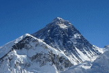
Mount Everest is the world's highest mountain, with a peak at 8848 metres (29,029 ft) above sea level
. It is located in the Mahalangur
section of the Himalayas
. The international boundary runs across the precise summit point. Its massif
includes neighboring peaks Lhotse
(8516 m), Nuptse
(7855 m) and Changtse
(7580 m).
In 1856, the Great Trigonometric Survey
of British India established the first published height of Everest, then known as Peak XV, at 29002 ft (8,840 m).
Sea level
Mean sea level is a measure of the average height of the ocean's surface ; used as a standard in reckoning land elevation...
. It is located in the Mahalangur
Mahalangur Himal
Mahālangūr Himāl is a section of the Himalaya in northeast Nepal and south-central Tibet extending from the pass Nangpa La between Rolwaling Himal and Cho Oyu east to the Arun River. It includes Mount Everest, Lhotse, Makalu, and Cho Oyu) -- four of Earth's six highest peaks...
section of the Himalayas
Himalayas
The Himalaya Range or Himalaya Mountains Sanskrit: Devanagari: हिमालय, literally "abode of snow"), usually called the Himalayas or Himalaya for short, is a mountain range in Asia, separating the Indian subcontinent from the Tibetan Plateau...
. The international boundary runs across the precise summit point. Its massif
Massif
In geology, a massif is a section of a planet's crust that is demarcated by faults or flexures. In the movement of the crust, a massif tends to retain its internal structure while being displaced as a whole...
includes neighboring peaks Lhotse
Lhotse
Lhotse is the fourth highest mountain on Earth and is connected to Everest via the South Col. In addition to the main summit at 8,516 metres above sea level, Lhotse Middle is and Lhotse Shar is...
(8516 m), Nuptse
Nuptse
Nuptse is a mountain in the Khumbu region of the Mahalangur Himal, in the Nepalese Himalayas. It lies two kilometres WSW of Mount Everest. Nuptse is Tibetan for "west peak", as it is the western segment of the Lhotse-Nuptse massif....
(7855 m) and Changtse
Changtse
Changtse is a mountain situated between the Main Rongbuk and East Rongbuk Glaciers in Tibet immediately north of Mount Everest. It is connected to Mount Everest via the North Col....
(7580 m).
In 1856, the Great Trigonometric Survey
Great Trigonometric Survey
The Great Trigonometric Survey was a project of the Survey of India throughout most of the 19th century. It was piloted in its initial stages by William Lambton, and later by George Everest. Among the many accomplishments of the Survey were the demarcation of the British territories in India and...
of British India established the first published height of Everest, then known as Peak XV, at 29002 ft (8,840 m).
Unanswered Questions
Discussions