

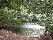
Wetland
Encyclopedia
Soil
Soil is a natural body consisting of layers of mineral constituents of variable thicknesses, which differ from the parent materials in their morphological, physical, chemical, and mineralogical characteristics...
is saturated
Aquifer
An aquifer is a wet underground layer of water-bearing permeable rock or unconsolidated materials from which groundwater can be usefully extracted using a water well. The study of water flow in aquifers and the characterization of aquifers is called hydrogeology...
with water
Water
Water is a chemical substance with the chemical formula H2O. A water molecule contains one oxygen and two hydrogen atoms connected by covalent bonds. Water is a liquid at ambient conditions, but it often co-exists on Earth with its solid state, ice, and gaseous state . Water also exists in a...
either permanently or seasonally. Wetlands are categorised by their characteristic vegetation
Vegetation
Vegetation is a general term for the plant life of a region; it refers to the ground cover provided by plants. It is a general term, without specific reference to particular taxa, life forms, structure, spatial extent, or any other specific botanical or geographic characteristics. It is broader...
, which is adapted to these unique soil conditions.
The water found in wetlands can be saltwater
Seawater
Seawater is water from a sea or ocean. On average, seawater in the world's oceans has a salinity of about 3.5% . This means that every kilogram of seawater has approximately of dissolved salts . The average density of seawater at the ocean surface is 1.025 g/ml...
, freshwater
Freshwater
Fresh water is naturally occurring water on the Earth's surface in ice sheets, ice caps, glaciers, bogs, ponds, lakes, rivers and streams, and underground as groundwater in aquifers and underground streams. Fresh water is generally characterized by having low concentrations of dissolved salts and...
, or brackish. Wetlands include swamp
Swamp
A swamp is a wetland with some flooding of large areas of land by shallow bodies of water. A swamp generally has a large number of hammocks, or dry-land protrusions, covered by aquatic vegetation, or vegetation that tolerates periodical inundation. The two main types of swamp are "true" or swamp...
s, marsh
Marsh
In geography, a marsh, or morass, is a type of wetland that is subject to frequent or continuous flood. Typically the water is shallow and features grasses, rushes, reeds, typhas, sedges, other herbaceous plants, and moss....
es, and bog
Bog
A bog, quagmire or mire is a wetland that accumulates acidic peat, a deposit of dead plant material—often mosses or, in Arctic climates, lichens....
s, among others.
Wetlands are found on every continent except Antarctica. One of the world's largest natural wetlands is the Pantanal
Pantanal
The Pantanal is a tropical wetland and one of the world's largest wetland of any kind. Most of it lies within the Brazilian state of Mato Grosso do Sul, but it extends into Mato Grosso and portions of Bolivia and Paraguay, sprawling over an area estimated at between and...
, which straddles Brazil
Brazil
Brazil , officially the Federative Republic of Brazil , is the largest country in South America. It is the world's fifth largest country, both by geographical area and by population with over 192 million people...
, Bolivia
Bolivia
Bolivia officially known as Plurinational State of Bolivia , is a landlocked country in central South America. It is the poorest country in South America...
, and Paraguay
Paraguay
Paraguay , officially the Republic of Paraguay , is a landlocked country in South America. It is bordered by Argentina to the south and southwest, Brazil to the east and northeast, and Bolivia to the northwest. Paraguay lies on both banks of the Paraguay River, which runs through the center of the...
in South America
South America
South America is a continent situated in the Western Hemisphere, mostly in the Southern Hemisphere, with a relatively small portion in the Northern Hemisphere. The continent is also considered a subcontinent of the Americas. It is bordered on the west by the Pacific Ocean and on the north and east...
. The main functions of wetlands are as water purification systems, flood control, shoreline stability, and as reservoirs of biodiversity
Biodiversity
Biodiversity is the degree of variation of life forms within a given ecosystem, biome, or an entire planet. Biodiversity is a measure of the health of ecosystems. Biodiversity is in part a function of climate. In terrestrial habitats, tropical regions are typically rich whereas polar regions...
. Wetlands may be converted for agriculture or development or constructed as a water management tool as in the recent developing field of Water Sensitive Urban Design.
The study of wetlands has recently been termed paludology in some publications. Wetlands also are known internationally as inland water or coastal/marine ecosystems.
The UN Millennium Ecosystem Assessment
Millennium Ecosystem Assessment
The Millennium Ecosystem Assessment, released in 2005, is an international synthesis by over 1000 of the world's leading biological scientists that analyses the state of the Earth’s ecosystems and provides summaries and guidelines for decision-makers...
determined that environmental degradation is more prominent within wetland systems than any other ecosystem
Ecosystem
An ecosystem is a biological environment consisting of all the organisms living in a particular area, as well as all the nonliving , physical components of the environment with which the organisms interact, such as air, soil, water and sunlight....
on Earth
Earth
Earth is the third planet from the Sun, and the densest and fifth-largest of the eight planets in the Solar System. It is also the largest of the Solar System's four terrestrial planets...
. International conservation
Conservation
Conservation may refer to:* Conservation movement, to protect animals, fungi, plants and their habitats** Conservation biology, the science of the protection and management of biodiversity...
efforts and the development of rapid assessment tools are being used in conjunction with each other to inform people about wetland issues.
Technical definitions
Wetlands have been categorized both as biomeBiome
Biomes are climatically and geographically defined as similar climatic conditions on the Earth, such as communities of plants, animals, and soil organisms, and are often referred to as ecosystems. Some parts of the earth have more or less the same kind of abiotic and biotic factors spread over a...
s and ecosystems. A patch of land that develops pools of water after a rain storm would not be considered a "wetland" though the land is wet. Wetlands have unique characteristics: they are generally distinguished from other water bodies or landforms based on their water level
Water level
Water level or gage height or stage is the elevation of the free surface of a stream, lake or reservoir relative to a specified datum ....
and on the types of plant
Plant
Plants are living organisms belonging to the kingdom Plantae. Precise definitions of the kingdom vary, but as the term is used here, plants include familiar organisms such as trees, flowers, herbs, bushes, grasses, vines, ferns, mosses, and green algae. The group is also called green plants or...
s that thrive within them. Specifically, wetlands are characterized as having a water table
Water table
The water table is the level at which the submarine pressure is far from atmospheric pressure. It may be conveniently visualized as the 'surface' of the subsurface materials that are saturated with groundwater in a given vicinity. However, saturated conditions may extend above the water table as...
that stands at or near the land surface either permanently or season
Season
A season is a division of the year, marked by changes in weather, ecology, and hours of daylight.Seasons result from the yearly revolution of the Earth around the Sun and the tilt of the Earth's axis relative to the plane of revolution...
ally for a long enough period each year to support aquatic plants. A concise definition is a community composed of hydric soil
Hydric soil
A hydric soil is a soil that formed under conditions of saturation, flooding, or ponding long enough during the growing season to develop anaerobic conditions in the upper part....
and hydrophytes.
Wetlands have also been described as ecotone
Ecotone
An ecotone is a transition area between two biomes but different patches of the landscape, such as forest and grassland. It may be narrow or wide, and it may be local or regional...
s, providing a transition between dry land and water bodies. Mitsch and Gosselink write that wetlands exist "...at the interface between truly terrestrial ecosystems and aquatic systems, making them inherently different from each other, yet highly dependent on both."
In environmental-decision making, there are subsets of definitions that are agreed upon to make regulatory and policy decisions.
Ramsar Convention definition
Under the Ramsar international wetland conservation treatyRamsar Convention
The Ramsar Convention is an international treaty for the conservation and sustainable utilization of wetlands, i.e., to stem the progressive encroachment on and loss of wetlands now and in the future, recognizing the fundamental ecological functions of wetlands and their economic, cultural,...
, an international agreement signed by 160 countries, wetlands are defined as follows:
- Article 1.1: "...wetlands are areas of marsh, fenFenA fen is a type of wetland fed by mineral-rich surface water or groundwater. Fens are characterised by their water chemistry, which is neutral or alkaline, with relatively high dissolved mineral levels but few other plant nutrients...
, peatland or water, whether natural or artificial, permanent or temporary, with water that is static or flowing, fresh, brackish or salt, including areas of marine water the depth of which at low tide does not exceed six metres."
- Article 2.1: "[Wetlands] may incorporate riparian and coastal zones adjacent to the wetlands, and islandIslandAn island or isle is any piece of sub-continental land that is surrounded by water. Very small islands such as emergent land features on atolls can be called islets, cays or keys. An island in a river or lake may be called an eyot , or holm...
s or bodies of marine water deeper than six metres at low tide lying within the wetlands".
Regional definitions
In the United States, wetlands are defined as "those areas that are inundated or saturated by surface or groundwater at a frequency and duration sufficient to support, and that under normal circumstances do support, a prevalence of vegetation typically adapted for life in saturated soil conditions. Wetlands generally include swamps, marshes, bogs and similar areas". This definition has been used in the enforcement of the Clean Water ActClean Water Act
The Clean Water Act is the primary federal law in the United States governing water pollution. Commonly abbreviated as the CWA, the act established the goals of eliminating releases of high amounts of toxic substances into water, eliminating additional water pollution by 1985, and ensuring that...
. Some US states, such as Massachusetts
Massachusetts
The Commonwealth of Massachusetts is a state in the New England region of the northeastern United States of America. It is bordered by Rhode Island and Connecticut to the south, New York to the west, and Vermont and New Hampshire to the north; at its east lies the Atlantic Ocean. As of the 2010...
and New York
New York
New York is a state in the Northeastern region of the United States. It is the nation's third most populous state. New York is bordered by New Jersey and Pennsylvania to the south, and by Connecticut, Massachusetts and Vermont to the east...
, have separate definitions that may differ from the federal government.
Characteristics
Wetlands vary widely due to local and regional differences in topography, hydrologyHydrology
Hydrology is the study of the movement, distribution, and quality of water on Earth and other planets, including the hydrologic cycle, water resources and environmental watershed sustainability...
, vegetation, and other factors, including human disturbance. Wetlands can be divided into two main classes: tidal and non-tidal areas.
Hydrology
Wetland hydrology is associated with the spatial and temporal dispersion, flow, and physiochemical attributes of surface and ground water in its reservoirs. Based on hydrology, wetlands can be categorized as riverine, lacustrineLacustrine
Lacustrine means "of a lake" or "relating to a lake".Specifically, it may refer to:*Lacustrine plain*Lacustrine delta-Fish:*Lacustrine goby , a type of small fish found in Philippine waters belonging to the Gobiidae family, known in Tagalog as dulong-See also:*Fluvial - of or relating a...
, and palustrine
Palustrine
Palustrine comes from the Latin word palus or marsh. Wetlands within this category include inland marshes and swamps as well as bogs, fens, tundra and floodplains...
. Sources of hydrological flows into wetlands are predominately precipitation, surface water, and ground water. Water flows out of wetlands by evapotranspiration
Evapotranspiration
Evapotranspiration is a term used to describe the sum of evaporation and plant transpiration from the Earth's land surface to atmosphere. Evaporation accounts for the movement of water to the air from sources such as the soil, canopy interception, and waterbodies...
, surface run-off, and sub-surface water outflow. Hydrodynamics (the movement of water through and from a wetland) affects hydroperiods (temporal fluctuations in water levels) by controlling the water balance and water storage within a wetland.
Landscape characteristics control wetland hydrology and hydro-chemistry. The O2 and CO2 concentrations of water depend on temperature and atmospheric pressure. Hydro-chemistry within wetlands is determined by the pH
PH
In chemistry, pH is a measure of the acidity or basicity of an aqueous solution. Pure water is said to be neutral, with a pH close to 7.0 at . Solutions with a pH less than 7 are said to be acidic and solutions with a pH greater than 7 are basic or alkaline...
, salinity
Salinity
Salinity is the saltiness or dissolved salt content of a body of water. It is a general term used to describe the levels of different salts such as sodium chloride, magnesium and calcium sulfates, and bicarbonates...
, nutrients, conductivity
Conductivity
Conductivity may refer to:*Electrical conductivity, a measure of a material's ability to conduct an electric current*Conductivity , also the specific conductance, is a measurement of the electrical conductance per unit distance in an electrolytic or aqueous solution*Ionic conductivity, a measure of...
, soil composition, hardness, and the sources of water. Water chemistry of wetlands varies across landscapes and climatic regions. Wetlands are generally minerotrophic with the exception of bogs.
Bogs receive their water from the atmosphere and therefore their water has low mineral ionic composition because ground water has a higher concentration of dissolved nutrients and minerals in comparison to precipitation.
The water chemistry of fens ranges from low pH and low minerals to alkaline with high accumulation of calcium
Calcium
Calcium is the chemical element with the symbol Ca and atomic number 20. It has an atomic mass of 40.078 amu. Calcium is a soft gray alkaline earth metal, and is the fifth-most-abundant element by mass in the Earth's crust...
and magnesium
Magnesium
Magnesium is a chemical element with the symbol Mg, atomic number 12, and common oxidation number +2. It is an alkaline earth metal and the eighth most abundant element in the Earth's crust and ninth in the known universe as a whole...
because they acquire their water from precipitation as well as ground water.
The role of salinity
Salinity has a strong influence on wetland water chemistry. In non-riverine wetlands, natural salinity is regulated by interactions between ground and surface water, which may be influenced by human activity.Soil
CarbonCarbon
Carbon is the chemical element with symbol C and atomic number 6. As a member of group 14 on the periodic table, it is nonmetallic and tetravalent—making four electrons available to form covalent chemical bonds...
is the major nutrient cycled within wetlands. Most nutrients, such as sulfur
Sulfur
Sulfur or sulphur is the chemical element with atomic number 16. In the periodic table it is represented by the symbol S. It is an abundant, multivalent non-metal. Under normal conditions, sulfur atoms form cyclic octatomic molecules with chemical formula S8. Elemental sulfur is a bright yellow...
, phosphorus
Phosphorus
Phosphorus is the chemical element that has the symbol P and atomic number 15. A multivalent nonmetal of the nitrogen group, phosphorus as a mineral is almost always present in its maximally oxidized state, as inorganic phosphate rocks...
, carbon, and nitrogen
Nitrogen
Nitrogen is a chemical element that has the symbol N, atomic number of 7 and atomic mass 14.00674 u. Elemental nitrogen is a colorless, odorless, tasteless, and mostly inert diatomic gas at standard conditions, constituting 78.08% by volume of Earth's atmosphere...
are found within the soil of wetlands. Anaerobic
Anaerobic respiration
Anaerobic respiration is a form of respiration using electron acceptors other than oxygen. Although oxygen is not used as the final electron acceptor, the process still uses a respiratory electron transport chain; it is respiration without oxygen...
and aerobic respiration in the soil influences the nutrient cycling of carbon, hydrogen, oxygen, and nitrogen, and the solubility of phosphorus thus contributing to the chemical variations in its water. Wetlands with low pH and saline conductivity may reflect the presence of acid sulfates and wetlands with average salinity levels can be heavily influenced by calcium or magnesium. Biogeochemical processes
Biogeochemistry
Biogeochemistry is the scientific discipline that involves the study of the chemical, physical, geological, and biological processes and reactions that govern the composition of the natural environment...
in wetlands are determined by soils with low redox
Redox
Redox reactions describe all chemical reactions in which atoms have their oxidation state changed....
potential.
Biota
The biota of a wetland system includes its vegetation zones and structure as well as animal populations and distribution which are highly dependent on water chemistry. The chemistry of water flowing into wetlands depends on the source of water and the geological material in which it flows through as well as the nutrients discharged from organic matter in the soils and plants at higher elevations in slope wetlands. Biota may vary within a wetland due to season or migratory animals.Flora
There are four main groups of hydrophytes that found in wetland systems throughout the world.Submerged
Submerged
Submerged is an action film, released in 2005. The film stars Steven Seagal, Christine Adams, William Hope, Gary Daniels, Alison King and Vinnie Jones. The film was directed by British director Anthony Hickox.- Plot :...
water plants. This type of vegetation in found completely underwater. It may range from sea grasses in inter-tidal zones to ribbonweed, the most common native plant found within Australian waterways. Submerged wetland vegetation can grow in saline and fresh-water conditions and may still possess a peak growing season. Endemic submerged species provide a food source for native fauna, habitat for invertrebrates, and also possess filtration capabilities.
Float
Float
-Float:* Public float, the free float of a public company is an estimate of number of shares of a stock held in public hands* Fishing float, a bite indicator used in angling...
ing water plants. Floating vegetation is usually small although it may take up a large surface area in a wetland system. These hydrophytes have small roots and are only found in slow-moving water with rich-nutrient level water Floating aquatic plants are a food resource for avian species. A common example seen in wetland systems is the Lily pad or the Australian native duckweed.
Emergent
Emergent
It may also mean:* Emergent , Neural Simulation Software* Emergent , a 2003 album by Gordian Knot* emergent plant, a plant which grows in water but which pierces the surface so that it is partially in air...
water plants. Emergent water plants can seen above the surface of the water but whose roots are completely submerged. These hydrophytes will store nutrients and will proliferate to counter-balance harmful algal bloom
Algal bloom
An algal bloom is a rapid increase or accumulation in the population of algae in an aquatic system. Algal blooms may occur in freshwater as well as marine environments. Typically, only one or a small number of phytoplankton species are involved, and some blooms may be recognized by discoloration...
s and invasive species. Common rush is a common native emergent water plan found in the continent of Australia. It can grow up to one metre high and flowers in spring and summer.
Surrounding tree
Tree
A tree is a perennial woody plant. It is most often defined as a woody plant that has many secondary branches supported clear of the ground on a single main stem or trunk with clear apical dominance. A minimum height specification at maturity is cited by some authors, varying from 3 m to...
s and shrub
Shrub
A shrub or bush is distinguished from a tree by its multiple stems and shorter height, usually under 5–6 m tall. A large number of plants may become either shrubs or trees, depending on the growing conditions they experience...
s. Surrounding wetland vegetation can be riparian or forested. Riparian vegetation grows close to river bank or coastal area stabilizing the shore, providing shade to regulate water temperature, and provides habitat to native communities. Trees surround many wetland areas promoting a carbon sink, stabilization, wind breaks, and erosion control. The Paperbark tree in Australia is commonly found in still or slow-moving water in swamps and creeks.
Fauna
FishFish
Fish are a paraphyletic group of organisms that consist of all gill-bearing aquatic vertebrate animals that lack limbs with digits. Included in this definition are the living hagfish, lampreys, and cartilaginous and bony fish, as well as various extinct related groups...
: Fish are more dependent on wetland ecosystems than any other type of habitat. Every single species of both fresh water and saltwater fish spends part of its life-cycle in a coastal wetland. 75% of the United States’ commercial fish and shellfish stocks depend solely on estuaries to survive. Tropical fish species need mangroves for critical hatchery and nursery grounds and the coral reef system for food.
Amphibian
Amphibian
Amphibians , are a class of vertebrate animals including animals such as toads, frogs, caecilians, and salamanders. They are characterized as non-amniote ectothermic tetrapods...
s: Frog
Frog
Frogs are amphibians in the order Anura , formerly referred to as Salientia . Most frogs are characterized by a short body, webbed digits , protruding eyes and the absence of a tail...
s are the most crucial amphibian species in wetland systems. Frogs need both terrestrial and aquatic habitats in which to reproduce and feed. While tadpoles control algal populations, adult frogs forage on insects. Frogs are used as an indicator of ecosystem health due to their thin skin which absorbs both nutrient and toxins from the surrounding environment resulting in an above average extinction rate in unfavorable and polluted environmental conditions.
Reptile
Reptile
Reptiles are members of a class of air-breathing, ectothermic vertebrates which are characterized by laying shelled eggs , and having skin covered in scales and/or scutes. They are tetrapods, either having four limbs or being descended from four-limbed ancestors...
s: Alligator
Alligator
An alligator is a crocodilian in the genus Alligator of the family Alligatoridae. There are two extant alligator species: the American alligator and the Chinese alligator ....
s and crocodile
Crocodile
A crocodile is any species belonging to the family Crocodylidae . The term can also be used more loosely to include all extant members of the order Crocodilia: i.e...
s are two common reptilian species. Alligators are found in fresh water along with the fresh water species of the crocodile. The saltwater crocodile is found in estuaries and mangroves and can be seen in the coastline bordering the Great Barrier Reef
Great Barrier Reef
The Great Barrier Reef is the world'slargest reef system composed of over 2,900 individual reefs and 900 islands stretching for over 2,600 kilometres over an area of approximately...
in Australia. The Florida Everglades is the only place in the world where both crocodiles and alligators co-exist. Snake
Snake
Snakes are elongate, legless, carnivorous reptiles of the suborder Serpentes that can be distinguished from legless lizards by their lack of eyelids and external ears. Like all squamates, snakes are ectothermic, amniote vertebrates covered in overlapping scales...
s, lizard
Lizard
Lizards are a widespread group of squamate reptiles, with nearly 3800 species, ranging across all continents except Antarctica as well as most oceanic island chains...
s, goanna
Goanna
Goanna is the name used to refer to any number of Australian monitor lizards of the genus Varanus, as well as to certain species from Southeast Asia.There are around 30 species of goanna, 25 of which are found in Australia...
s, and turtle
Turtle
Turtles are reptiles of the order Testudines , characterised by a special bony or cartilaginous shell developed from their ribs that acts as a shield...
s also can be seen throughout wetlands.
Mammals: Multiple small mammals as well as large herbivore and apex species such as the Florida Panther live within and around wetlands. The wetland ecosystem attracts mammals due to its prominent seed sources, invertebrate populations, and numbers of small reptiles and amphibians.
Marsupials: The platypus
Platypus
The platypus is a semi-aquatic mammal endemic to eastern Australia, including Tasmania. Together with the four species of echidna, it is one of the five extant species of monotremes, the only mammals that lay eggs instead of giving birth to live young...
(Ornithorhynchus anatinus) is found in eastern Australia living in freshwater rivers or lakes, and much like the beaver creates dams, create burrows for shelter and protection. The platypus swims through the use of webbed feet. Platypuses feed on insect larvae, worms, or other freshwater insects hunting mainly by night by the use of their bill. They turn up mud on the bottom of the lake or river, and with the help of the electroreceptors located on the bill, unearth insects and freshwater insects. The platypus stores their findings in special pouches behind their bill and consumes its prey upon returning to the surface.
Insects and invertebrate
Invertebrate
An invertebrate is an animal without a backbone. The group includes 97% of all animal species – all animals except those in the chordate subphylum Vertebrata .Invertebrates form a paraphyletic group...
s: These species total more than half of the 100,000 known animal species in wetlands. Insects and invertebrates can be submerged in the water or soil, on the surface, and in the atmosphere.
Algae
AlgaeAlgae
Algae are a large and diverse group of simple, typically autotrophic organisms, ranging from unicellular to multicellular forms, such as the giant kelps that grow to 65 meters in length. They are photosynthetic like plants, and "simple" because their tissues are not organized into the many...
are diverse water plants that can vary in size, color, and shape. Algae occur naturally in habitats such as inland lakes, inter-tidal zones, and damp soil and provide a dedicated food source for animals, fish, and invertebrates. There are three main groups of algae:
Plankton
Plankton
Plankton are any drifting organisms that inhabit the pelagic zone of oceans, seas, or bodies of fresh water. That is, plankton are defined by their ecological niche rather than phylogenetic or taxonomic classification...
are algae which are microscopic
Microscopic
The microscopic scale is the scale of size or length used to describe objects smaller than those that can easily be seen by the naked eye and which require a lens or microscope to see them clearly.-History:...
, free-floating algae. This algae is so tiny that on average, if fifty of these microscopic algae were lined up end-to-end, it would only measure one millimetre, which is only 3/100's of an inch! Plankton are the basis of the food web and are responsible for primary production
Primary production
400px|thumb|Global oceanic and terrestrial photoautotroph abundance, from September [[1997]] to August 2000. As an estimate of autotroph biomass, it is only a rough indicator of primary production potential, and not an actual estimate of it...
in the ocean using photosynthesis to make food.
Filamentous algae are long strands of algae cells that form floating mats.
Chara
Chara
-Geography:*Chara , a rural locality in Zabaykalsky Krai, Russia*Chara Airport located there*Chara River, a river in Russia-Science:*Chara , a genus of algae in the family Characeae...
and Nitella
Nitella
Nitella is a genus of alga in the family Characeae.- Species :Some species in the genus include:* Nitella acuminata A. Braun ex Wallman* Nitella annandalei B.P. Pal* Nitella australiensis J.C. van Raam...
algae are upright algae that look like a submerged plant with roots.
Biota importance
Many of the flora and fauna that are part of wetlands are disappearing. As most species are endemic to wetlands, biologists and other scientists routinely census wetland biota to look for threatened populations. The IUCN's global red list can be accessed on the internet to determine if there is any species within a particular wetland system that has been identified as needing assistance to prevent extinction.Temperature
Temperatures vary greatly depending on the location of the wetland. Many of the world's wetlands are in temperate zones (midway between the North or South Pole and the equator). In these zones, summers are warm and winters are cold, but temperatures are not extreme. However, wetlands found in the tropic zone, around the equator, are warm year round. Wetlands on the Arabian PeninsulaArabian Peninsula
The Arabian Peninsula is a land mass situated north-east of Africa. Also known as Arabia or the Arabian subcontinent, it is the world's largest peninsula and covers 3,237,500 km2...
, for example, can reach 50 °C (122 °F) and would therefore be subject to rapid evaporation. In northeastern Siberia
Siberia
Siberia is an extensive region constituting almost all of Northern Asia. Comprising the central and eastern portion of the Russian Federation, it was part of the Soviet Union from its beginning, as its predecessor states, the Tsardom of Russia and the Russian Empire, conquered it during the 16th...
, which has a polar climate, wetland temperatures can be as low as −50 °C (−58 °F). In a moderate zone, such as the Gulf of Mexico
Gulf of Mexico
The Gulf of Mexico is a partially landlocked ocean basin largely surrounded by the North American continent and the island of Cuba. It is bounded on the northeast, north and northwest by the Gulf Coast of the United States, on the southwest and south by Mexico, and on the southeast by Cuba. In...
, a typical temperature might be 11 °C (51 °F).
Rainfall
The amount of rainfall a wetland receives varies widely according to its location. Wetlands in Wales, Scotland, and Western Ireland typically receive about 1500 mm (or 60 in) per year. In some places in Southeast Asia, where heavy rains occur, they can receive up to 10,000 mm (about 200 in). In the northern areas of North America, wetlands exist where as little as 180 mm (7 inches) of rain fall each year.Temporal variation:
- Perennial systems
- Seasonal systems
- EpisodicEpisodicEpisodic can refer to* The nature of television series that are divided into short programs. See Episode* Episodic memory relates to the types of memory that result from specific incidents in a lifetime...
(periodic or intermittent) systems - Surface flow may occur in some segments, with subsurface flow in other segments
- EphemeralEphemeralEphemeral things are transitory, existing only briefly. Typically the term is used to describe objects found in nature, although it can describe a wide range of things....
(short-lived) systems - Migratory species
Human-disturbance:
- Encroachment
- Drainage
- Development
- Over-grazing
- MiningMiningMining is the extraction of valuable minerals or other geological materials from the earth, from an ore body, vein or seam. The term also includes the removal of soil. Materials recovered by mining include base metals, precious metals, iron, uranium, coal, diamonds, limestone, oil shale, rock...
- Unsustainable water use
- Ecosystem Stress
- Water Scarcity
- Endangered species
- Disruption of breeding grounds
- Imbalance in sediment load and nutrient filtration
The peatswamps of South-east Asia
In Southeast Asia, peatswamp forests and soils are being drained, burnt, mined, and overgrazed contributing severely to climate change. As a result of peat drainage, the organic carbon that was built up over thousands of years and is normally under water, is suddenly exposed to the air. It decomposes and turns into carbon dioxideCarbon dioxide
Carbon dioxide is a naturally occurring chemical compound composed of two oxygen atoms covalently bonded to a single carbon atom...
(CO2), which is released into the atmosphere. Peat fires cause the same process and in addition create enormous clouds of smoke that cross international borders, such as happen every year in Southeast Asia. Peatlands form only 3% of all the world’s land area, however, their degradation equals 7% of all fossil fuel
Fossil fuel
Fossil fuels are fuels formed by natural processes such as anaerobic decomposition of buried dead organisms. The age of the organisms and their resulting fossil fuels is typically millions of years, and sometimes exceeds 650 million years...
CO2 emissions.
Through the building of dams, Wetlands International
Wetlands International
Wetlands International is a global organisation that works to sustain and restore wetlands and their resources for people and biodiversity. It is an independent, not-for-profit, global organisation, supported by government and NGO membership from around the world...
is halting the drainage of peatlands in Southeast Asia, hoping to mitigate CO2 emissions. Concurrent wetland restoration techniques include reforestation with native tree species as well as setting up community fire brigades. This sustainable approach can be seen in Central Kalimantan
Kalimantan
In English, the term Kalimantan refers to the Indonesian portion of the island of Borneo, while in Indonesian, the term "Kalimantan" refers to the whole island of Borneo....
and Sumatra
Sumatra
Sumatra is an island in western Indonesia, westernmost of the Sunda Islands. It is the largest island entirely in Indonesia , and the sixth largest island in the world at 473,481 km2 with a population of 50,365,538...
, Indonesia
Indonesia
Indonesia , officially the Republic of Indonesia , is a country in Southeast Asia and Oceania. Indonesia is an archipelago comprising approximately 13,000 islands. It has 33 provinces with over 238 million people, and is the world's fourth most populous country. Indonesia is a republic, with an...
.
Aquaculture
Concerns are developing over certain aspects of farm fishing, which uses natural waterways to harvest fish for human consumption and pharmaceuticals. This practice has become especially popular within Asia and the South Pacific. Its impact downstream upon much larger water ways has negatively influenced many small island developing states.Ecosystem Services.
The function of natural wetlands can be classified by their ecosystem benefits. The United Nations Millennium Ecosystem Assessment and Ramsar Convention found wetlands to be of biosphere significance and societal importance in the following areas:• Flood control
• Groundwater replenishment
• Shoreline stabilisation and storm protection
• Water purification
• Reservoirs of biodiversity
• Wetland products
• Cultural values
• Recreation and tourism
• Climate change mitigation and adaptation
The economic worth of the ecosystem services provided to
society by intact, naturally functioning wetlands is
frequently much greater than the perceived benefits of
converting them to ‘more valuable’ intensive land use –
particularly as the profits from unsustainable use often go to
relatively few individuals or corporations, rather than being
shared by society as a whole.-Ramsar convention
Unless otherwise cited,Ecosystem services is based on the following series of references.
Flood control.
Major wetland type: floodplainStorage Reservoirs and Flood Protection. The wetland system of floodplains is formed from major rivers downstream from their headwaters. Notable river systems that produce large spans of floodplain include the Nile River (Africa), Mississippi River
Mississippi River
The Mississippi River is the largest river system in North America. Flowing entirely in the United States, this river rises in western Minnesota and meanders slowly southwards for to the Mississippi River Delta at the Gulf of Mexico. With its many tributaries, the Mississippi's watershed drains...
(USA), Amazon River
Amazon River
The Amazon of South America is the second longest river in the world and by far the largest by waterflow with an average discharge greater than the next seven largest rivers combined...
(South America), Yangtze River
Yangtze River
The Yangtze, Yangzi or Cháng Jiāng is the longest river in Asia, and the third-longest in the world. It flows for from the glaciers on the Tibetan Plateau in Qinghai eastward across southwest, central and eastern China before emptying into the East China Sea at Shanghai. It is also one of the...
(China), Danube River (Central Europe) and Murray-Darling River (Australia). "The floodplains of major rivers act as natural storage reservoirs, enabling excess water to spread out over a wide area, which reduces its depth and speed. Wetlands close to the headwaters of streams and rivers can slow down rainwater runoff and spring snowmelt so that it doesn’t run straight off the land into water courses. This can help prevent sudden, damaging floods downstream.”
Human-Impact. Converting wetlands through drainage and development have contributed to the issue of irregular flood control through forced adaption of water channels to narrower corridors due to loss of wetland area. These new channels must manage the same amount of precipitation causing flood peaks to be [higher or deeper] and floodwaters to travel faster.
Water management engineering developments in the past century have degraded these wetlands through the construction on artificial embankments. These constructions may be classified as dykes, bunds, levees, weirs, barrages and dams but serve the single purpose of concentrating water into a select source or area. Wetland water sources that were once spread over slowly over a large, shallow area are pooled into deep, concentrated locations. Loss of wetland floodplains results in more severe and damaging flooding. Catastrophic human impact in the Mississippi River floodplains was seen in death of several hundred individuals during a levee breach in New Orleans caused by Hurricane Katrina. Ecological catastrophic events from human-made embankments have been noticed along the Yangtze River floodplains after the where the middle of the river has become prone to more frequent and damaging flooding including the loss of riparian vegetation, a 30% loss of the vegetation cover throughout the river’s basin, a doubling of the percentage of the land affected by soil erosion, and a reduction in reservoir capacity through siltation build-up in floodplain lakes.
Groundwater replenishment
Major wetland type: marsh, swamp, & subterranean karst and cave hydrological systemsThe surface water which is the water visibly seen in wetland systems only represents a portion of the overall water cycle which also includes atmospheric water and groundwater. Wetland systems are directly linked to groundwater and a crucial regulator of both the quantity and quality of water found below the ground. Wetland systems that are made of permeable sediments like limestone or occur in areas with highly variable and fluctuating water tables especially have a role in groundwater replenishment or water recharge. Sediments that are porous allow water to filter down through the soil and overlying rock into aquifers which are the source of 95% of the world’s drinking water. Wetlands can also act as recharge areas when the surrounding water table is low and as a discharge zone when it is too high. Karst (cave) systems are a unique example of this system and are a connection of underground rivers influenced by rain and other forms of precipitation. These wetland systems are capable of regulating changes in the water table on upwards of 130 meters (426.5 feet).
Human-Impact. Groundwater is an important source of water for drinking and irrigation of crops. Over 1 billion people in Asia and 65% of the public water sources in Europe source 100% of their water from groundwater. Irrigation is a massive use of groundwater with 80% of the world’s groundwater used for agricultural production.
Unsustainable abstraction of groundwater has become a major concern. In the Commonwealth of Australia
Australia
Australia , officially the Commonwealth of Australia, is a country in the Southern Hemisphere comprising the mainland of the Australian continent, the island of Tasmania, and numerous smaller islands in the Indian and Pacific Oceans. It is the world's sixth-largest country by total area...
, water licensing is being implemented to control use of the water in major agricultural regions. On a global scale, groundwater deficits and water scarcity is one of the most pressing concerns facing the 21st century.
Shoreline stabilisation and storm protection.
Wetland type: Mangroves, Coral Reefs, SaltmarshTidal and inter-tidal wetland systems protect and stabilize coastal zones. Coral reefs provide a protective barrier to coastal shoreline. Mangroves stabilize the coastal zone from the interior and will migrate with the shoreline to remain adjacent to the boundary of the water. The main conservation benefit these systems have against storms and tidal waves is the ability to reduce the speed and height of waves and floodwaters.
Human-Impact. The sheer number of people who live and work near the coast is expected to grow immensely over the next 50 years. From an estimated 200 million people that currently live in low-lying coastal regions, the development of urban coastal centers is projected to increase the population by 5 fold within 50 years.
The United Kingdom has begun the concept of managed coastal realignment. This management technique provides shoreline protection through restoration of natural wetlands rather than through applied engineering.
Water Purification.
Wetland Type: Floodplain, Mudflat, Saltmarsh, MangrovesNutrient Retention. Wetlands cycle both sediments and nutrients balancing terrestrial and aquatic ecosystems. A natural function of wetland vegetation is the up-take and storage of nutrients found in the surrounding soil and water. These nutrients are retained in the system until the plant dies or is harvested by animals or humans. Wetland vegetation productivity is linked to the climate, wetland type, and nutrient availability. The grasses of fertile floodplains such as the Nile produce the highest yield including
plants such as Arundo donax(giant reed), Cyperus papyrus (papyrus), Phragmites (reed) and Typha (cattail, bulrush).
Sediment Traps. Rainfall run-off is responsible for moving sediment through waterways. These sediments move towards larger and more sizable waterways through a natural process that moves water towards oceans. All types of sediments which may be composed of clay, sand, silt, and rock can be carried into wetland systems through this process. Reedbeds or forests located in wetlands act as physical barriers to slow waterflow and trap sediment.
Water purification. Many wetland systems possess biofilters, hydrophytes, and organisms that in addition to nutrient up-take abilities have the capacity to remove toxic substances that have come from pesticides, industrial discharges, and mining activities. The up-take occurs through most parts of the plant including the stems, roots, and leaves . Floating plants can absorb and filter heavy metals. Eichhornia crassipes (water hyacinth), Lemna (duckweed) and Azolla (water fern) store iron and copper commonly found in wastewater
Wastewater
Wastewater is any water that has been adversely affected in quality by anthropogenic influence. It comprises liquid waste discharged by domestic residences, commercial properties, industry, and/or agriculture and can encompass a wide range of potential contaminants and concentrations...
. Many fast-growing plants rooted in the soils of wetlands such as Typha (cattail) and Phragmites (reed) also aid in the role of heavy metal up-take. Animals such as the oyster can filter more than 200 liters (53 gallons) of water per day while grazing for food, removing nutrients, suspended sediments, and chemical contaminants in the process.
Capacity. The ability of wetland systems to store nutrients and trap sediment is highly efficient and effective but each system has a threshold. An overabundance of nutrient input from fertilizer run-off, sewage effluent, or non-point pollution will cause eutrophication
Eutrophication
Eutrophication or more precisely hypertrophication, is the movement of a body of water′s trophic status in the direction of increasing plant biomass, by the addition of artificial or natural substances, such as nitrates and phosphates, through fertilizers or sewage, to an aquatic system...
. Upstream erosion from deforestation can overwhelm wetlands making them shrink in size and see dramatic biodiversity loss through excessive sedimentation load. The capacity of wetland vegetation to store heavy metals is affected by waterflow, number of hectares (acres), climate, and type of plant.
Human-Impact. Introduced hydrophytes in different wetland systems can have devastating results. The introduction of water hyacinth, a native plant of South America into Lake Victoria in East Africa as well as duckweed into non-native areas of Queensland, Australia, have overtaken entire wetland systems suffocating the ecosystem due to their phenomenal growth rate and ability to float and grow on the surface of the water.
Constructed Wetlands
The function of most natural wetland systems is not to manage to wastewater, however, their high potential for the filtering and the treatment of pollutants has been recognized by environmental engineers that specialize in the area of wastewater treatment. These constructed artificial wetland systems are highly-controlled environments that intend to mimic the occurrences of soil, flora, and microorganisms in natural wetlands to aid in treating wastewater effluent. Artificial wetlands provide the ability to experiment with flow regimes, micro-biotic composition, and flora in order to produce the most efficient treatment process. Other advantages are the control of retention times and hydraulic channels. The most important factors of constructed wetlands are the water flow processes combined with plant growth. Constructed wetland systems can be surface flow systems with only free-floating macrophytes, floating-leaved macrophytes, or submerged macrophytes; however, typical free water surface systems are usually constructed with emergent macrophytes. Constructed wetlands can be adapted to treat raw sewage, secondary domestic sludge, enhance water quality of oxidation ponds’ discharge, storm waters, mining waste, and industrial and agricultural waste effluents. International wastewater management programs can be seen from Kolkata (Calcutta), India to Arcata, California, USA.Kolkata’s constructed wetland. Kolkata is an example of how constructed wetlands are being utilized in developing countries.
Using the purification capacity of wetlands, the Indian city of Kolkata (Calcutta) has pioneered a system of sewage disposal that is both efficient and environmentally-friendly. Built to house one million people, Kolkata is now home to over 10 million, many living in slums. But the 8,000-hectare East Kolkata Wetlands Ramsar Site, a patchwork of tree-fringed canals, vegetable plots, rice paddies and fish ponds – and the 20,000 people that work in them – daily transform one-third of the city’s sewage and most of its domestic refuse into a rich harvest of fish and fresh vegetables. For example, the Mudialy Fishermen’s Cooperative Society is a collective of 300 families that lease 70 hectares into which wastewater from the city is released. Through a series of natural treatment processes – including the use of Eichhornia crassipes and other plants for absorbing oil, grease and heavy metals – the Cooperative has turned the area into a thriving fish farm and nature park. In 2005/06, the Cooperative sold fish worth over US$135,000 and shared income of more than US$55,000 among its members.
Reservoirs of biodiversity.
Wetland systems' rich biodiversity is becoming a focal point at International Treaty Conventions and within the World Wildlife Fund organization due to the high number of species present in wetlands, the small global geographic area of wetlands, the number of species which are endemic to wetlands, and the high productivity of wetland systems. Hundred of thousands of animal species, 20,000 of them vertebrates, are living in wetland systems. The discovery rate of fresh water fish is at 200 new species per year.Biodiverse river basins. The Amazon holds 3,000 species of fresh water fish species within the boundaries of its basin whose function it is to disperse the seeds of trees. One of its key species, the Piramutaba catfish, Brachyplatystoma vaillantii, migrates more than 3,300 km (2,051 miles) from its nursery grounds near the mouth of the Amazon River to its spawning grounds in Andean tributaries (400 m or 437 yards above sea level) distributing plants seed along the route.
Productive intertidal zones. Intertidal mudflats have a similar productivity even while possessing a low number of species. The abundance of invertebrates found within the mud are a food source for migratory waterfowl.
Critical life-stage habitat. Mudflats, saltmarshes, mangroves, and seagrass beds contain bother species richness and productivity, and are home to important nursery areas for many commercial fish stocks.
Genetic Diversity. Many species in wetland systems are unique due to the long period of time that the ecosystem has been physically isolated from other aquatic sources. The number of endemic species in Lake Baikal in Russia classifies it as a hotspot for biodiversity and one of the most biodiverse wetlands in the entire world.
Lake Baikal
Lake Baikal
Lake Baikal is the world's oldest at 30 million years old and deepest lake with an average depth of 744.4 metres.Located in the south of the Russian region of Siberia, between Irkutsk Oblast to the northwest and the Buryat Republic to the southeast, it is the most voluminous freshwater lake in the...
.
Evidence from a research study by Mazepova et. al suggest that the number of crustacean species endemic to Baikal Lake (>690 species and subspecies) exceeds the number of the same groups of animals inhabiting all the fresh water bodies of Eurasia together. Its 150 species of free-living Platyhelminthes alone is analogous to the entire number in all of Eastern Siberia. The 34 species and subspecies number of Baikal sculpins is more than twice the number of the analogous fauna that inhabits Eurasia. One of most exciting discoveries was made by A.V. Shoshin who registered about 300 species of free-living nematodes using only 6 near-shore sampling localities in the Southern Baikal. "If we will take into consideration, that about 60 % of the animals can be found nowhere else except Baikal, it may be assumed that the lake may be the biodiversity center of the Eurasian continent."
Human Impact. Biodiversity loss occurs in wetland systems through land use changes, habitat destruction, pollution, exploitation of resources, and invasive species. Vulnerable, threatened, and endangered species number at 17% of waterfowl, 38% of fresh-water dependent mammals, 33% of fresh water fish, 26% of fresh water amphibians, 72% of fresh water turtles, 86% of marine turtles, 43% of crocodilians and 27% of coral reef-building species.
The impact of maintaining biodiversity is seen at the local level through job creation, sustainability, and community productivity. A good example is the Lower Mekong basin which runs through Cambodia, Laos, and Vietnam. Supporting over 55 million people, the sustainability of the region is enhanced through wildlife tours. The US state of Florida has estimated that US$ 1.6 billion was generated in state revenue from recreational activities associated with wildlife. Sustainable harvesting for medicinal remedies found in native wetlands plants in the Caribbean and Australia include the Red Mangrove Rhizophora mangle which possesses antibacterial, wound-healing, anti-ulcer effects, and antioxidant properties.
Wetland Products.
Wetland systems naturally produce an array of vegetation and other ecological products that can harvested for personal and commercial use.The most significant of these is fish which have all or part of their life-cycle occur within a wetland system. Fresh and saltwater fish are the main source of protein for one billion people and comprise 15% of an additional two billion people’s diets. In addition, fish generate a fishing industry that provides 80% of the income and employment to residents in developing countries. Another food staple found in wetland systems is rice, a popular grain that is consumed at the rate of 1/5 of the total global calorie count. In Bangladesh, Cambodia and Vietnam, where rice paddies are predominant on the landscape, rice consumption reach 70%.
Food converted to sweeteners and carbohydrates include the sago palm of Asia and Africa (cooking oil), the nipa palm of Asia (sugar, vinegar, alcohol, and fodder) and honey collection from mangroves. More than supplemental dietary intake, this produce sustains entire villages. Coastal Thailand villages earn the key portion of their income from sugar production while the country of Cuba relocates more than 30,000 hives each year to track the seasonal flowering of the mangrove Avicennia.
Other mangrove- derived products.
• fuelwood
• salt (produced by evaporating seawater)
• animal fodder
• traditional medicines (e.g. from mangrove bark)
• fibers for textiles
• dyes and tannins
Human Impact. Over-fishing is the major problem for sustainable use of wetlands. The field of aquaculture within the fisheries industries is eliminating mass areas of wetland systems through practices seen such as in the shrimp farming industry's destruction of mangroves. Aquaculture is continuing to develop rapidly throughout the Asia-Pacific region specifically in China with world holdings in Asia equal to 90% of the total number of aquaculture farms and 80% of its global value. Threats to rice fields mainly stem from inappropriate water management, introduction of invasive alien species, agricultural fertilizers, pesticides, and land use changes. Industrial-scale production of palm oil threatens the
biodiversity of wetland ecosystems in parts of south-east Asia, Africa, and other developing countries. Exploitation can occur at the community level as is sometimes seen throughout coastal villages of Southern Thailand where each resident may obtain for themselves every consumable of the mangrove forest (fuelwood, timber, honey, resins, crab, and shellfish) which then becomes threatened through increasing population and continual harvest. Other issues that occur on a global level include a uneven contribution to climate change, point and non-point pollution, and air and water quality issues due to destructive wetland practices.
Wetlands and climate change
'All references within this section were obtained from the following source'.Scientific Projections.
“Low water and occasional drying of the wetland bottom during droughts (dry marsh phase) stimulate plant recruitment from a diverse seed bank and increase productivity by mobilizing nutrients. In contrast, high water during deluges (lake marsh phase) causes turnover in plant populations and creates greater interspersion of element cover and open water, but lowers overall productivity. During a cover cycle that ranges from open water to complete vegetation cover, annual net primary productivity may vary 20-fold.”Mitigation and Adaption.
Wetlands perform two important functions in relation to climate change. They have mitigation effects through their ability to sink carbon, and adaptation effects through their ability to store and regulate water.Conservation
Wetlands have historically been the victim of large draining efforts for real estate developmentReal estate development
Real estate development, or Property Development, is a multifaceted business, encompassing activities that range from the renovation and re-lease of existing buildings to the purchase of raw land and the sale of improved land or parcels to others...
, or flooding for use as recreational lakes. Since the 1970s, more focus has been put on preserving wetlands for their natural function yet by 1993 half the world's wetlands had been drained. Wetlands provide a valuable flood control function. Wetlands are very effective at filtering and cleaning water pollution
Water pollution
Water pollution is the contamination of water bodies . Water pollution occurs when pollutants are discharged directly or indirectly into water bodies without adequate treatment to remove harmful compounds....
, (often from agricultural runoff from the farms that replaced the wetlands in the first place). To replace these wetland ecosystem services
Ecosystem services
Humankind benefits from a multitude of resources and processes that are supplied by natural ecosystems. Collectively, these benefits are known as ecosystem services and include products like clean drinking water and processes such as the decomposition of wastes...
enormous amounts of money had to be spent on water purification
Water purification
Water purification is the process of removing undesirable chemicals, materials, and biological contaminants from contaminated water. The goal is to produce water fit for a specific purpose...
plants, along with the remediation measures for controlling floods: dam and levee construction.
In order to produce sustainable wetlands, short-term, private-sector profits need to come secondary to global equity. Decision-makers must valuate wetland type, provided ecosystem service, long-term benefit, and current subsidies inflating valuation on either the private or public sector side. Analysis using the impact of hurricanes versus storm protection features projected wetland valuation at US$33,000/hectare/year.
Balancing wetland conservation with the needs of people
Wetlands are vital ecosystems that provide livelihoods for the millions of people who live in and around them. The Millennium Development GoalsMillennium Development Goals
The Millennium Development Goals are eight international development goals that all 193 United Nations member states and at least 23 international organizations have agreed to achieve by the year 2015...
(MDGs) called for different sectors to join forces to secure wetland environments in the context of sustainable development and improving human wellbeing. A three-year project carried out by Wetlands International in partnership with the International Water Management Institute
International Water Management Institute
The International Water Management Institute is a non-profit research organisation with headquarters in Colombo, Sri Lanka, and offices across Africa and Asia...
found that it is possible to conserve wetlands while improving the livelihoods of people living among them. Case studies conducted in Malawi and Zambia looked at how dambo
Dambo
Dambo is a word used for a class of complex shallow wetlands in central, southern and eastern Africa, particularly in Zambia and Zimbabwe. They are generally found in higher rainfall flat plateau areas, and have river-like branching forms which may be nowhere very large, but common enough to add up...
s – wet, grassy valleys or depressions where water seeps to the surface – can be farmed sustainably to improve livelihoods. Mismanaged or overused dambos often become degraded, however, using a knowledge exchange between local farmers and environmental managers, a protocol was developed using soil and water management practices. Project outcomes included a high yield of crops, development of sustainable farming techniques, and adequate water management generating enough water for use as irrigation. Before the project, there were cases where people had died from starvation due to food shortages. By the end of it, many more people had access to enough water to grow vegetables. A key achievement was that villagers had secure food supplies during long, dry months. They also benefited in other ways: nutrition was improved by growing a wider range of crops, and villagers could also invest in health and education by selling produce and saving money.
Ramsar Convention
The Convention on Wetlands of International Importance, especially as Waterfowl Habitat, or Ramsar Convention, is an international treatyTreaty
A treaty is an express agreement under international law entered into by actors in international law, namely sovereign states and international organizations. A treaty may also be known as an agreement, protocol, covenant, convention or exchange of letters, among other terms...
designed to address global concerns regarding wetland loss and degradation. The primary purposes of the treaty are to list wetlands of international importance and to promote their wise use, with the ultimate goal of preserving the world's wetlands. Methods include restricting access to the majority portion of wetland areas, as well as educating the public to combat the misconception that wetlands are wastelands. The Convention works closely with five International Organisation Partners. These are: Birdlife International
BirdLife International
BirdLife International is a global Partnership of conservation organisations that strives to conserve birds, their habitats and global biodiversity, working with people towards sustainability in the use of natural resources...
, IUCN, International Water Management Institute, Wetlands International and World Wide Fund for Nature
World Wide Fund for Nature
The World Wide Fund for Nature is an international non-governmental organization working on issues regarding the conservation, research and restoration of the environment, formerly named the World Wildlife Fund, which remains its official name in Canada and the United States...
. The partners provide technical expertise, help conduct or facilitate field studies and provide financial support. The IOPs also participate regularly as observers in all meetings of the Conference of the Parties and the Standing Committee and as full members of the Scientific and Technical Review Panel.
New Zealand
Over 90% of the wetlands in New ZealandNew Zealand
New Zealand is an island country in the south-western Pacific Ocean comprising two main landmasses and numerous smaller islands. The country is situated some east of Australia across the Tasman Sea, and roughly south of the Pacific island nations of New Caledonia, Fiji, and Tonga...
have been drained since Europe
Europe
Europe is, by convention, one of the world's seven continents. Comprising the westernmost peninsula of Eurasia, Europe is generally 'divided' from Asia to its east by the watershed divides of the Ural and Caucasus Mountains, the Ural River, the Caspian and Black Seas, and the waterways connecting...
an settlement, predominantly to create farmland. Wetlands now have a degree of protection under the Resource Management Act
Resource Management Act
The Resource Management Act passed in 1991 in New Zealand is a significant, and at times, controversial Act of Parliament. The RMA promotes the sustainable management of natural and physical resources such as land, air and water...
.
South Africa
The South African Department of Environmental Affairs and Tourism in conjunction with the departments of Water Affairs and Forestry, and of Agriculture, supports the conservation and rehabilitation of wetlands through the Working for Wetlands program. The aim of this program is to encourage the protection, rehabilitation and sustainable use of South African wetlands through co-operative governance and partnerships. The program is also a poverty relief effort, providing employment in wetland maintenance.Sweden
The Swedish national wetland inventory (VMI) is one of the world's most extensive systematic inventories of nature types that has ever been done. VMI has surveyed the wetlands of SwedenSweden
Sweden , officially the Kingdom of Sweden , is a Nordic country on the Scandinavian Peninsula in Northern Europe. Sweden borders with Norway and Finland and is connected to Denmark by a bridge-tunnel across the Öresund....
below the alpine region during a 25-year period. In total 35 000 objects (sites) are included in VMI, corresponding to an area of 4.3 million hectares, or 10% of the land area of Sweden. The aim of the survey has been to increase the general knowledge of wetlands in Sweden, as a basis for environmental monitoring and natural resources planning. By investigating the impact of human activities on wetlands and identifying the most valuable wetlands, their values can be preserved for future generations. The results from the inventory were also meant to function as background data for the authorities' decisions concerning e.g. drainage permits.
United States
The USA centred its wetland conservation efforts through legislation enforcement creating requirements that if a wetland had to be drained; developers had to offset the loss through the generation of artificial wetlands. A restoration project by the State of Florida in the Everglades acquired U.S. Sugar Corporation land allowing for water delivery, water treatment, and water storage of sufficient quantity and quality to mimic the Everglades' natural system.Republic of Macedonia
The fragments of wetland habitats that are still in existence in the Republic of Macedonia are present as marsh or swamp communities. These patches are present at Studenchishte (small fragment near Ohrid Lake), Pelagonia (village Chepigovo), Negortsi Spa, Bansko, Belchishte wetland and Monospitovo marsh. The large areas of swamps that used to be present in most of the valleys in contemporary Republic of Macedonia have undergone a great transformation over the last 50-60 years. The main cause for their reduction is land reclamation, drainage, and conversion into arable land for agricultural needs (Smith and Smith, 2003). Some of the remaining wetlands (Negortsi Spa, Bansko) are of great importance for understanding the genesis of marsh vegetation in the Republic of Macedonia as many mountainous marshes and peat bogs suffered anthropogenic transformation due to the capturing of water from mountain springs and streams for the purposes of generating drinking water (Smith, 2003). Accordingly, the fragmentation and transformation of previous swamps had a major impact on faunal distribution and abundance. Amphibians are the most affected species along with invertebrate and vertebrate groups including the European Otter (Lutra Lutra L.). It is listed as Nearly Threatened according to the IUCN’s red list and mainly found now only in the Belchishte wetland (Smith 2003; Smith and Smith, 2003). The otter has importance for the wetland communities not just in Macedonia but also in other European countries such as the Netherlands and Germany (Reuther, 1995; Reuther et al., 2001). Macedonian wetlands lie within the network of some of the bigger rivers in Macedonia including the Vardar River, a catchment area equal to 80% of Macedonian territory..
Valuation
The value of a wetland system to the earth and to humankind is one of the mostimportant valuations that can be computed for sustainable development
Sustainable development
Sustainable development is a pattern of resource use, that aims to meet human needs while preserving the environment so that these needs can be met not only in the present, but also for generations to come...
. A guideline involving assessing a wetland, keeping inventories of known wetlands, and monitoring the same wetlands over time is the current process that is used to educate environmental decision-makers such as governments on the importance of wetland protection and conservation.
Important considerations
- Constructed Wetlands take 10-100 years to fully resemble the vegetative composition of a natural wetland.
- Artificial wetlands do not have hydric soil. The soil has very low levels of organic carbon and total nitrogen compared to natural wetland systems.
- Organic matter can be added to degraded natural wetlands to help restore their productivity before the wetland is destroyed.
Assessment
Rapid assessment.Five steps to assessing a wetland
- Collect general biodiversity data in order to inventory and prioritize wetland species, communities and ecosystems. Obtain baseline biodiversity information for a given area.
- Gather information on the status of a focus or target species such as threatened species. Collect data pertaining to the conservation of a specific species.
- Gain information on the effects of human or natural disturbance (changes) on a given area or species.
- Gather information that is indicative of the general ecosystem health or condition of a specific wetland ecosystem.
- Determine the potential for sustainable use of biological resources in a particular wetland ecosystem.
Inventory
Developing a global inventory of wetlands has proven to be a large and difficult undertaking. Current efforts are based on available data, but both classification and spatial resolution have proven to be inadequate for regional or site-specific environmental management decision-making. It is difficult to identify small, long, and narrow wetlands within the landscape. Many of today’s remote sensing satellites do not have sufficient spatial and spectral resolution to monitor wetland conditions, although multispectral IKONOS and QuickBird data may offer improved spatial resolutions once it is 4 m or higher. Majority of the pixels are just mixtures of several plant species or vegetation types and are difficult to isolate which translates into an inability to classify the vegetation that defines the wetland. Improved remote sensing information, coupled with good knowledge domain on wetlands will facilitate expanded efforts in wetland monitoring and mapping. This will also be extremely important because we expect to see major shifts in species composition due to both anthropogenic land use and natural changes in the environment caused by climate change.Monitoring
MappingA wetland system needs to be monitored over time to in order to assess whether it is functioning at an ecologically sustainable level or whether it is becoming degraded. Degraded wetlands will suffer a loss in water quality, a high number of threatened and endangered species, and poor soil conditions.
Due to the large size of wetlands, mapping is an effective tool to monitor wetlands. There are many remote sensing methods that can be used to map wetlands. Remote-sensing technology permits the acquisition of timely digital data on a repetitive basis. This repeat coverage allows wetlands, as well as the adjacent land-cover and land-use types, to be monitored seasonally and/or annually. Using digital data provides a standardized data-collection procedure and an opportunity for data integration within a geographic information system
Geographic Information System
A geographic information system, geographical information science, or geospatial information studies is a system designed to capture, store, manipulate, analyze, manage, and present all types of geographically referenced data...
. Traditionally, Landsat 5 Thematic Mapper (TM), Landsat 7 Enhanced Thematic Mapper Plus (ETM + ), and the SPOT 4 and 5 satellite systems have been used for this purpose. More recently, however, multispectral IKONOS and QuickBird data, with spatial resolutions of 4 m by 4 m and 2.44 m by 2.44 m, respectively, have been shown to be excellent sources of data when mapping and monitoring smaller wetland habitats and vegetation communities.
For example, Detroit Lakes Wetland Management District assessed area wetlands in Michigan, USA using remote sensing. Through using this technology, satellite images were taken over a large geographic area and extended period. In addition, using this technique was less costly and time-consuming compared to the older method using visual interpretation of aerial photographs. In comparison, most aerial photographs also require experienced interpreters to extract information based on structure and texture while the interpretation of remote sensing data only requires analysis of one characteristic (spectral).
However, there are a number of limitations associated with this type of image acquisition. Analysis of wetlands has proved difficult because to obtain the data it is often linked to other purposes such as the analysis of land cover or land use. Practically, many natural wetlands are difficult to monitor as these areas are quite often difficult to access and require exposure to native wildlife and potential endemic disease.
Further improvements
Methods to develop a classification system for specific biota of interest could assist with technological advances that will allow for identification at a very high accuracy rate. The issue of the cost and expertise involved in remote sensing technology is still a factor hindering further advancements in image acquisition and data processing. Future improvements in current wetland vegetation mapping could include the use of more recent and better geospatial data when it is available.
List of wetland types
Wetland types:- A—Marine and Coastal Zone wetlands
- Marine waters—permanent shallow waters less than six metres deep at low tide; includes sea bays, straits
- Subtidal aquatic beds; includes kelp beds, seagrasses, tropical marine meadows
- Coral reefs
- Rocky marine shores; includes rocky offshore islands, sea cliffs
- Sand, shingle or pebble beaches; includes sand bars, spits, sandy islets
- Intertidal mud, sand or salt flats
- Intertidal marshes; includes saltmarshes, salt meadows, saltings, raised salt marshes, tidal brackish and freshwater marshes
- Intertidal forested wetlands; includes mangrove swamps, nipa swamps, tidal freshwater swamp forests
- Brackish to saline lagoons and marshes with one or more relatively narrow connections with the sea
- Freshwater lagoons and marshes in the coastal zone
- Non-tidal freshwater forested wetlands
- B—Inland wetlands
- Permanent rivers and streams; includes waterfalls
- Seasonal and irregular rivers and streams
- Inland deltas (permanent)
- Riverine floodplains; includes river flats, flooded river basins, seasonally flooded grassland, savanna and palm savanna
- Permanent freshwater lakes (> 8 ha); includes large oxbow lakes
- Seasonal/intermittent freshwater lakes (> 8 ha), floodplain lakes
- Permanent saline/brackish lakes
- Seasonal/intermittent saline lakes
- Permanent freshwater ponds (< 8 ha), marshes and swamps on inorganic soils; with emergent vegetation waterlogged for at least most of the growing season
- Seasonal/intermittent freshwater ponds and marshes on inorganic soils; includes sloughs, potholes; seasonally flooded meadows, sedge marshes
- Permanent saline/brackish marshes
- Seasonal saline marshes
- Shrub swamps; shrub-dominated freshwater marsh, shrub carr, alder thicket on inorganic soils
- Freshwater swamp forest; seasonally flooded forest, wooded swamps; on inorganic soils
- Peatlands; forest, shrub or open bogs
- Alpine and tundra wetlands; includes alpine meadows, tundra pools, temporary waters from snow melt
- Freshwater springs, oases and rock pools
- Geothermal wetlands
- Inland, subterranean karst wetlands
- C—Human-made wetlands
- Water storage areas; reservoirs, barrages, hydro-electric dams, impoundments (generally > 8 ha)
- Ponds, including farm ponds, stock ponds, small tanks (generally < 8 ha)
- Aquaculture ponds; fish ponds, shrimp ponds
- Salt exploitation; salt pans, salines
- Excavations; gravel pits, borrow pits, mining pools
- Wastewater treatment; sewage farms, settling ponds, oxidation basins
- Irrigated land and irrigation channels; rice fields, canals, ditches
- Seasonally flooded arable land, farm land
- Canals
Variations of names for wetland systems:
- SwampSwampA swamp is a wetland with some flooding of large areas of land by shallow bodies of water. A swamp generally has a large number of hammocks, or dry-land protrusions, covered by aquatic vegetation, or vegetation that tolerates periodical inundation. The two main types of swamp are "true" or swamp...
- Freshwater swamp forestFreshwater swamp forestFreshwater swamp forests, or flooded forests, are forests which are inundated with freshwater, either permanently or seasonally. They normally occur along the lower reaches of rivers and around freshwater lakes...
- Coniferous swampConiferous swampConiferous swamps are forested wetlands in which the dominant trees are lowland conifers such as northern white cedar . The soil in these swamp areas are typically saturated for most of the growing season and are occasionally inundated by seasonal storms or winter snow melt.The substrate is usually...
- Peat swamp forestPeat swamp forestPeat swamp forests are tropical moist forests where waterlogged soils prevent dead leaves and wood from fully decomposing, which over time creates a thick layer of acidic peat...
- Freshwater swamp forest
- Slough
- Flooded grasslands and savannasFlooded grasslands and savannasFlooded grasslands and savannas is a terrestrial biome. Its component ecoregions are generally located at subtropical and tropical latitudes, which are flooded seasonally or year-round...
- Constructed wetlandConstructed wetlandA constructed wetland or wetpark is an artificial wetland, marsh or swamp created as a new or restored habitat for native and migratory wildlife, for anthropogenic discharge such as wastewater, stormwater runoff, or sewage treatment, for land reclamation after mining, refineries, or other...
- Riparian zoneRiparian zoneA riparian zone or riparian area is the interface between land and a river or stream. Riparian is also the proper nomenclature for one of the fifteen terrestrial biomes of the earth. Plant habitats and communities along the river margins and banks are called riparian vegetation, characterized by...
- FenFenA fen is a type of wetland fed by mineral-rich surface water or groundwater. Fens are characterised by their water chemistry, which is neutral or alkaline, with relatively high dissolved mineral levels but few other plant nutrients...
- Vernal PoolVernal poolVernal pools, also called vernal ponds or ephemeral pools, are temporary pools of water. They are usually devoid of fish, and thus allow the safe development of natal amphibian and insect species...
See also
- Converted wetlandConverted wetlandUnder the swampbuster program, converted wetlands are wetlands that were drained or altered to improve agricultural production after December 23, 1985, the date swampbuster was enacted...
- Saline marshlands
- Wetland conservationWetland conservationWetland conservation is aimed at protecting and preserving areas where water exists at or near the Earth's surface, such as swamps, marshes and bogs. Wetlands cover at least six per cent of the Earth and have become a focal issue for conservation due to the ecosystem services they provide...
Further reading
- Mitsch, W.J., J.G. Gosselink, C.J. Anderson, and L. Zhang. (2009) "Wetland Ecosystems". John Wiley & Sons, Inc., New York, 295 pp.
- Ghabo, A. A. (2007) Wetlands Characterization; Use by Local Communities and Role in Supporting Biodiversity in the Semiarid Ijara District, Kenya. Terra Nuova East Africa. Wetlands in drylands.
- 1987 U.S. Army Corps of Engineers Wetland delineation manual
- Dugan, Patrick (editor) (1993) Wetlands in Danger, World Conservation Atlas Series
- Brinson, M. (1993) A Hydrogeomorphic Classification of Wetlands
- Fredrikson, Leigh H. (1983) "Wetlands: A Vanishing Resource" Yearbook of Agriculture
- W.H. MacKenzie and J.R. Moran (2004) "Wetlands of British Columbia: A Guide to Identification. Ministry of Forests, Land Management Handbook 52. http://www.for.gov.bc.ca/hfd/pubs/Docs/Lmh/Lmh52.pdf
External links
- WetlandInfo: Queensland Department Environment and Natural Resource
- US Fish & Wildlife Service: National Wetlands Inventory
- Wetlands: The Ecological Effect of Loss (Research article)Pôle-relais zones humides littorales de la façade atlantique, Manche et Mer du Nord
- Marshlands of Iberá (in English and Spanish)
- Wetlands Water Quality Information Center, U.S. Department of Agriculture
- Centro Studi Naturalistici
- Wetlands legal updates
- Wetland of Hong Kong
- Forum des Marais Atlantiques - Pôle-relais zones humides littorales de la façade atlantique, Manche et Mer du Nord
- Wetlands International - A non-profit global organisation to sustain and restore wetlands, their resources and biodiversity for future generations