
Jhelum River
Encyclopedia
- "Hydaspes" redirects here. For the historic battle, see Battle of the Hydaspes.
Jehlum River or Jhelum River (icon) , (Shahmukhi)) is a river that flows in India
India
India , officially the Republic of India , is a country in South Asia. It is the seventh-largest country by geographical area, the second-most populous country with over 1.2 billion people, and the most populous democracy in the world...
and Pakistan
Pakistan
Pakistan , officially the Islamic Republic of Pakistan is a sovereign state in South Asia. It has a coastline along the Arabian Sea and the Gulf of Oman in the south and is bordered by Afghanistan and Iran in the west, India in the east and China in the far northeast. In the north, Tajikistan...
. It is the largest and most western of the five rivers of Punjab
Punjab region
The Punjab , also spelled Panjab |water]]s"), is a geographical region straddling the border between Pakistan and India which includes Punjab province in Pakistan and the states of the Punjab, Haryana, Himachal Pradesh, Chandigarh and some northern parts of the National Capital Territory of Delhi...
, and passes through Jhelum District
Jhelum District
Jhelum District is in the Punjab province of Pakistan. According the 1998 census the district had a population of 936,957, of which 31.48% were urban. Jhelum is known for providing a large number of soldiers to the British and later to the Pakistan armed forces due to which it is also known as...
. It is a tributary of the Chenab River
Chenab River
The Chenab River چنRiver' آب) is a major river of Jammu and Kashmir and the Punjab in Pakistan. It forms in the upper Himalayas in the Lahaul and Spiti district of Himachal Pradesh, India, and flows through the Jammu region of Jammu and Kashmir into the plains of the Punjab, Pakistan...
and has a total length of about 505 miles (813 kilometers).
History
The river Jhelum is called Vitastā in the RigvedaRigveda
The Rigveda is an ancient Indian sacred collection of Vedic Sanskrit hymns...
and Hydaspes by the ancient Greeks
Ancient Greece
Ancient Greece is a civilization belonging to a period of Greek history that lasted from the Archaic period of the 8th to 6th centuries BC to the end of antiquity. Immediately following this period was the beginning of the Early Middle Ages and the Byzantine era. Included in Ancient Greece is the...
. The Vitasta is mentioned as one of the major rivers by the holy scriptures of the Indo-Aryans — the Rigveda
Rigveda
The Rigveda is an ancient Indian sacred collection of Vedic Sanskrit hymns...
. It has been speculated that the Vitastā must have been one of the seven rivers (sapta-sindhu) mentioned so many times in the Rigveda. The name survives in the Kashmiri name for this river as Vyeth. According to the major religious work Srimad Bhagavatam, the Vitastā is one of the many transcendental rivers flowing through the land of Bharata, or ancient India.
Ancient Greece
Ancient Greece is a civilization belonging to a period of Greek history that lasted from the Archaic period of the 8th to 6th centuries BC to the end of antiquity. Immediately following this period was the beginning of the Early Middle Ages and the Byzantine era. Included in Ancient Greece is the...
, as were most mountains and streams; the poet Nonnus
Nonnus
Nonnus of Panopolis , was a Greek epic poet. He was a native of Panopolis in the Egyptian Thebaid, and probably lived at the end of the 4th or early 5th century....
in the Dionysiaca
Dionysiaca
The Dionysiaca is an ancient epic poem and the principal work of Nonnus. It is an epic in 48 books, the longest surviving poem from antiquity at 20,426 lines, composed in Homeric dialect and dactylic hexameters, the main subject of which is the life of Dionysus, his expedition to India, and his...
(section 26, line 350) makes the Hydaspes a titan
Titan (mythology)
In Greek mythology, the Titans were a race of powerful deities, descendants of Gaia and Uranus, that ruled during the legendary Golden Age....
-descended god, the son of the sea-god Thaumas
Thaumas
In Greek mythology, Thaumas was a sea god, son of Pontus and Gaia. He married an Oceanid, Electra . The children of Thaumas and Electra were the Harpies and Iris, the goddess of rainbows and a messenger of the gods; according to some, also Arke.Thaumas was also the name of a centaur...
and the cloud-goddess Elektra
Pleiades (Greek mythology)
The Pleiades , companions of Artemis, were the seven daughters of the titan Atlas and the sea-nymph Pleione born on Mount Cyllene. They are the sisters of Calypso, Hyas, the Hyades, and the Hesperides...
. He was the brother of Iris
Iris (mythology)
In Greek mythology, Iris is the personification of the rainbow and messenger of the gods. As the sun unites Earth and heaven, Iris links the gods to humanity...
, the goddess of the rainbow
Rainbow
A rainbow is an optical and meteorological phenomenon that causes a spectrum of light to appear in the sky when the Sun shines on to droplets of moisture in the Earth's atmosphere. It takes the form of a multicoloured arc...
, and half-brother to the Harpies
Harpy
In Greek mythology, a harpy was one of the winged spirits best known for constantly stealing all food from Phineas...
, the snatching winds. Since the river is in a country foreign to the ancient Greeks
Ancient Greece
Ancient Greece is a civilization belonging to a period of Greek history that lasted from the Archaic period of the 8th to 6th centuries BC to the end of antiquity. Immediately following this period was the beginning of the Early Middle Ages and the Byzantine era. Included in Ancient Greece is the...
, it is not clear whether they named the river after the god, or whether the god Hydaspes was named after the river.
Alexander the Great and his army crossed the Jhelum in BC 326 at the Battle of the Hydaspes River
Battle of the Hydaspes River
The Battle of the Hydaspes River was fought by Alexander the Great in 326 BC against King Porus of the Hindu Paurava kingdom on the banks of the Hydaspes River in the Punjab near Bhera in what is now modern-day Pakistan...
where it is believed that he defeated the Indian king, Porus. According to Arrian (Anabasis, 29), he built a city "on the spot whence he started to cross the river Hydaspes", which he named Bukephala (or Bucephala
Bucephala
Bucephala may refer to:* Bucephala , the goldeneye, a duck genus* Bucephala is the name of at least two Greek cities:** Bucephala, or Alexandria Bucephalus, a city founded by Alexander the Great and named in honor of his horse, Bucephalus...
) to honour his famous horse Bukephalus or Bucephalus
Bucephalus
Bucephalus or Bucephalas was Alexander the Great's horse and one of the most famous actual horses of antiquity. Ancient accounts state that Bucephalus died after the Battle of the Hydaspes in 326 BC, in what is now modern Pakistan, and is buried in Jalalpur Sharif outside of Jhelum, Pakistan...
which was buried in Jalalpur Sharif
Jalalpur Sharif
Jalalpur Sharif is a small town located in Jhelum, and is a Union Council of Pind Dadan Khan Tehsil in Jhelum District, Punjab province, Pakistan...
. It is thought that ancient Bukephala was near the site of modern Jhelum City. According to a historian of Gujrat district, Mansoor Behzad Butt, Bukephalus was buried in Jalalpur Sharif
Jalalpur Sharif
Jalalpur Sharif is a small town located in Jhelum, and is a Union Council of Pind Dadan Khan Tehsil in Jhelum District, Punjab province, Pakistan...
, but the people of Mandi Bahauddin
Mandi Bahauddin
Mandi Bahauddin is the capital of Mandi Bahauddin District in the Punjab province of Pakistan. The town is some 220 metres above the sea level and is situated in upper Punjab, between the rivers Jhelum and Chenab . Mandi Bahauddin city is situated some 50 km from the M2 - Motorway of...
, a district close to Jehlum, believed that their tehsil Phalia was named after Bucephalus, Alexander's dead horse. They say that the name Phalia was the distortion of the word Bucephala. The waters of the Jhelum are allocated to Pakistan
Pakistan
Pakistan , officially the Islamic Republic of Pakistan is a sovereign state in South Asia. It has a coastline along the Arabian Sea and the Gulf of Oman in the south and is bordered by Afghanistan and Iran in the west, India in the east and China in the far northeast. In the north, Tajikistan...
under the terms of the Indus Waters Treaty
Indus Waters Treaty
The Indus Waters Treaty is a water-sharing treaty between the Republic of India and Islamic Republic Of Pakistan, brokered by the World Bank . The treaty was signed in Karachi on September 19, 1960 by Indian Prime Minister Jawaharlal Nehru and President of Pakistan Mohammad Ayub Khan...
.
Verinag In Kashmir
Verinag is situated at a distance of approximately 80 km from Srinagar. Reached through the link road, it is located at a height of 1,876 m. It is believed that the Verinag spring inKashmir is the chief source of the river Jhelum. There is an octagonal base at the spring, surrounded by a covered passage.
Considered to be the source of the River Jhelum, often termed as the lifeline of the province of Jammu and Kashmir, the beautiful region of Verinag is indeed one of the best options of a weekend getaway from Srinagar. A tour to Verinag reveals the secret of the source of the River Jhelum, a spring after which the region itself has been named.
The Verinag Spring, named after Nila Nag, the son of the famous Hindu sage Kashyap Rishi, to whom, goes the credit of establishing the territory of Jammu and Kashmir is one of the principle tourist attractions of a tour to Verinag. the spring, which was originally shaped in a circular form was given a change of shape during the reign of the Mughal Emperor Jahangir in 1620, when he gave orders to renovate the spring in the Mughal traditional shape of an octagon. Today, picturesque in its settings and surrounded by tall Pine trees, the Verinag Spring is characterized by waters which are calm and sparklingly clear. Besides a glimpse of the Verinag Spring, a tour to Verinag is made even more special by the sight of several varieties of colorful flowers, gently swaying to the rhythm of the cool, mountain air.
The easiest and fastest way of reaching Verinag is by air. The nearest airport is at the Badgam District around 80 km away from the village of Verinag.
Verinag is well-connected to a number of other regions of Jammu and Kashmir. There are a number of well maintained roads which lead to Verinag.
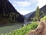
Course
Kashmir
Kashmir is the northwestern region of the Indian subcontinent. Until the mid-19th century, the term Kashmir geographically denoted only the valley between the Great Himalayas and the Pir Panjal mountain range...
in India. It flows through Srinagar and the Wular lake
Wular Lake
Wular Lake , India's largest fresh water lake is located in Bandipore district in the Indian state of Jammu and Kashmir. It is also one of the largest freshwater lakes in Asia. The lake basin was formed as a result of tectonic activity and is fed by the Jhelum River...
before entering Pakistan through a deep narrow gorge. The Kishenganga (Neelum) River, the largest tributary of the Jhelum, joins it, at Domel Muzaffarabad
Muzaffarabad
Muzaffarabad is the capital of Pakistan Occupied Kashmir, Pakistan. It is located in Muzaffarabad District on the banks of the Jhelum and Neelum rivers...
, as does the next largest, the Kunhar River
Kunhar River
The Kunhar River also known as ' Persian: "eye's repose" is long river, located primarily in the Khyber Pakhtunkhwa province, northern Pakistan. It is in the Indus River watershed basin.-Route:...
of the Kaghan valley
Kaghan Valley
The Kaghan Valley is a valley in the north-east of Mansehra District of the Khyber Pakhtunkhwa Province of Pakistan. It attracts many tourists from around the world. The inhabitants were affected by the earthquake disaster on 8 October 2005....
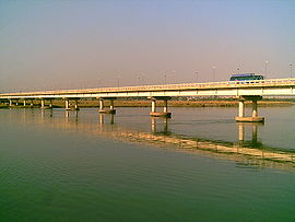
. It also connects with rest of Pakistan and Pakistan Occupied Kashmir on Kohala Bridge
Kohala Bridge
The Kohala Bridge across the Jhelum River, a tributary of the Indus River, forms part of one of the land routes from the Azad Kashmir to the rest of Pakistan....
east of Circle Bakote. It is then joined by the Poonch river, and flows into the Mangla Dam
Mangla Dam
The Mangla Dam is located on the Jhelum River in the Mirpur District of Azad Kashmir, Pakistan. It is the sixteenth largest dam in the world. It was built from 1961 to 1967 with funding from the World Bank. The project was designed and supervised by Binnie & Partners of London, and it was built...
reservoir in the district of Mirpur
Mirpur District
Mirpur District is a district in the disputed and divided state of [Jammu and Kashmir]. The district is named after the main city, Mirpur. The District of Mirpur has a population of 371,000 and covers an area of . The district is mainly mountainous with some plains...
. The Jhelum enters the Punjab in the Jhelum District
Jhelum District
Jhelum District is in the Punjab province of Pakistan. According the 1998 census the district had a population of 936,957, of which 31.48% were urban. Jhelum is known for providing a large number of soldiers to the British and later to the Pakistan armed forces due to which it is also known as...
. From there, it flows through the plains of Pakistan's Punjab, forming the boundary between the Chaj and Sindh Sagar Doab
Doab
A Doab is a term used in India and Pakistan for a "tongue" or tract of land lying between two confluent rivers...
s. It ends in a confluence with the Chenab
Chenab River
The Chenab River چنRiver' آب) is a major river of Jammu and Kashmir and the Punjab in Pakistan. It forms in the upper Himalayas in the Lahaul and Spiti district of Himachal Pradesh, India, and flows through the Jammu region of Jammu and Kashmir into the plains of the Punjab, Pakistan...
at Trimmu
Trimmu
Trimmu Barrage is a barrage on the River Chenab in the Jhang District of the Punjab province of Pakistan. It is situated downstream of the confluence of the River Jhelum and River Chenab...
in District Jhang
Jhang
- Demographics :According to 1981 census of Pakistan population of Jhang was 1,970,944 with the 434,495 housing units in Jhang. In 1998 census, population of Jhang was 2,834,545, whose annually growth rate was 2.16%. Male population was 1,474,099 and female population was 1,360,446...
. The Chenab merges with the Sutlej
Sutlej
The Sutlej River is the longest of the five rivers that flow through the historic crossroad region of Punjab in northern India and Pakistan. It is located north of the Vindhya Range, south of the Hindu Kush segment of the Himalayas, and east of the Central Sulaiman Range in Pakistan.The Sutlej...
to form the Panjnad River
Panjnad River
Panjnad River is a river at the extreme end of Bahawalpur district in Punjab, Pakistan. Panjnad River is formed by successive confluence of the five rivers of Punjab, namely Jhelum, Chenab, Ravi, Beas and Sutlej...
which joins the Indus River
Indus River
The Indus River is a major river which flows through Pakistan. It also has courses through China and India.Originating in the Tibetan plateau of western China in the vicinity of Lake Mansarovar in Tibet Autonomous Region, the river runs a course through the Ladakh district of Jammu and Kashmir and...
at Mithankot
Mithankot
Mithankot , is located in southern Punjab, Pakistan.- Geography :Mithankot is located on the right bank of the Indus River, only a short distance downstream from its junction with Panjnad River. The latter is formed by successive confluence of the five rivers of Punjab, namely Jhelum, Chenab,...
.
Dams and barrages
Indus Basin Project
The Indus Basin Project is a water control project that resulted from a treaty, Indus Waters Treaty, signed between India and Pakistan in 1960 that guaranteed that Pakistan would receive water from the Indus River independent from upstream control by India....
, including the following:
- Mangla DamMangla DamThe Mangla Dam is located on the Jhelum River in the Mirpur District of Azad Kashmir, Pakistan. It is the sixteenth largest dam in the world. It was built from 1961 to 1967 with funding from the World Bank. The project was designed and supervised by Binnie & Partners of London, and it was built...
, completed in 1967, is one of the largest earthfill dams in the world, with a storage capacity of 5900000 acre.ft - Rasul BarrageRasul BarrageRasul Barrage is a barrage on the River Jhelum in Mandi Bahauddin District of the Punjab province of Pakistan. It is situated 72 km downstream of Mangla Dam....
, constructed in 1967, has a maximum flow of 850,000 ft³/s (24,000 m³/s). - Trimmu BarrageTrimmuTrimmu Barrage is a barrage on the River Chenab in the Jhang District of the Punjab province of Pakistan. It is situated downstream of the confluence of the River Jhelum and River Chenab...
, constructed in 1939 some 90 km from Mari Shah Sakhira town, at the confluence with the Chenab, has maximum discharge capacity of 645,000 ft³/s (18,000 m³/s). - Harahpur (Victoria Bridge) Constructed in 1933 Approximate 5 km from malakwal near Chak nizam Village. Its length is 1 km mainly used by Pakistan Railways but there is a passage for light vehicle (motor cycle, cycle and by boot at both side.
Canals
- The Upper Jhelum Canal runs from Mangla DamMangla DamThe Mangla Dam is located on the Jhelum River in the Mirpur District of Azad Kashmir, Pakistan. It is the sixteenth largest dam in the world. It was built from 1961 to 1967 with funding from the World Bank. The project was designed and supervised by Binnie & Partners of London, and it was built...
to the ChenabChenab RiverThe Chenab River چنRiver' آب) is a major river of Jammu and Kashmir and the Punjab in Pakistan. It forms in the upper Himalayas in the Lahaul and Spiti district of Himachal Pradesh, India, and flows through the Jammu region of Jammu and Kashmir into the plains of the Punjab, Pakistan...
. - The Rasul-Qadirabad Link Canal runs from the Rasul BarrageRasul BarrageRasul Barrage is a barrage on the River Jhelum in Mandi Bahauddin District of the Punjab province of Pakistan. It is situated 72 km downstream of Mangla Dam....
to the Chenab. - The ChashmaChashma (Pakistan)Chashma Colony is located in Punjab, Pakistan. It is situated in Mianwali District near Kundian at the left bank of river Indus, near Koh-i-Suleiman mountain range. Chashma Colony is famous for the well-known Chashma Barrage built on river Indus...
-Jhelum Link Canal runs from the Chashma Barrage on the Indus RiverIndus RiverThe Indus River is a major river which flows through Pakistan. It also has courses through China and India.Originating in the Tibetan plateau of western China in the vicinity of Lake Mansarovar in Tibet Autonomous Region, the river runs a course through the Ladakh district of Jammu and Kashmir and...
to the Jhelum river downstream of Rasul BarrageRasul BarrageRasul Barrage is a barrage on the River Jhelum in Mandi Bahauddin District of the Punjab province of Pakistan. It is situated 72 km downstream of Mangla Dam....
. This is 40 km away from Mari Shah Sakhira town.