
Snow line
Encyclopedia
The interplay of altitude
Altitude
Altitude or height is defined based on the context in which it is used . As a general definition, altitude is a distance measurement, usually in the vertical or "up" direction, between a reference datum and a point or object. The reference datum also often varies according to the context...
and latitude
Latitude
In geography, the latitude of a location on the Earth is the angular distance of that location south or north of the Equator. The latitude is an angle, and is usually measured in degrees . The equator has a latitude of 0°, the North pole has a latitude of 90° north , and the South pole has a...
affects the precise placement of the snow line at a particular location. At or near the equator
Equator
An equator is the intersection of a sphere's surface with the plane perpendicular to the sphere's axis of rotation and containing the sphere's center of mass....
, it is typically situated at approximately 4,500 meters (or about 15,000 feet) above sea level
Sea level
Mean sea level is a measure of the average height of the ocean's surface ; used as a standard in reckoning land elevation...
. As one moves towards the Tropic of Cancer
Tropic of Cancer
The Tropic of Cancer, also referred to as the Northern tropic, is the circle of latitude on the Earth that marks the most northerly position at which the Sun may appear directly overhead at its zenith...
and Tropic of Capricorn
Tropic of Capricorn
The Tropic of Capricorn, or Southern tropic, marks the most southerly latitude on the Earth at which the Sun can be directly overhead. This event occurs at the December solstice, when the southern hemisphere is tilted towards the Sun to its maximum extent.Tropic of Capricorn is one of the five...
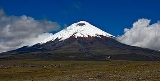
, the parameter at first increases: in the Himalayas
Himalayas
The Himalaya Range or Himalaya Mountains Sanskrit: Devanagari: हिमालय, literally "abode of snow"), usually called the Himalayas or Himalaya for short, is a mountain range in Asia, separating the Indian subcontinent from the Tibetan Plateau...
the permanent snow line can be as high as 5,700 metres (18,700 feet), whilst on the Tropic of Capricorn no permanent snow exists at all in the Andes
Andes
The Andes is the world's longest continental mountain range. It is a continual range of highlands along the western coast of South America. This range is about long, about to wide , and of an average height of about .Along its length, the Andes is split into several ranges, which are separated...
because of the extreme aridity: Monte Pissis
Monte Pissis
Monte Pissis is an extinct volcano in La Rioja Province, Argentina. The mountain is the third-highest in the Western Hemisphere, and is located about 550 km north of Aconcagua....
in Argentina is the highest mountain in the world to be free of glaciers to its summit. Beyond the Tropics the snow line becomes progressively lower as the latitude increases, to just below 3,000 metres in the Alps
High Alps
The High Alps are those parts of the Alps unsuitable for habitation or seasonal transhumance. This includes all regions higher than 3,000 m above sea level, as well as most regions between 2,500 m and 3,000 m The High Alps are those parts of the Alps unsuitable for habitation or seasonal...
and falling all the way to sea level itself at the ice cap
Ice cap
An ice cap is an ice mass that covers less than 50 000 km² of land area . Masses of ice covering more than 50 000 km² are termed an ice sheet....
s near the poles
Polar climate
Regions with a polar climate are characterized by a lack of warm summers . Regions with polar climate cover over 20% of the Earth. The sun shines 24 hours in the summer, and barely ever shines at all in the winter...
.
In addition, the relative location to the nearest coastline can influence the altitude of the snow line. Areas near a coast might have a lower snow line than areas of the same altitude and latitude situated in a landmass interior due to more winter snowfall and because the average summer temperature
Temperature
Temperature is a physical property of matter that quantitatively expresses the common notions of hot and cold. Objects of low temperature are cold, while various degrees of higher temperatures are referred to as warm or hot...
of the surrounding lowlands would be warmer away from the sea. (This applies even in the tropics, since areas far from the sea will have larger diurnal temperature ranges and potentially less moisture, as observed with Kilimanjaro and presently glacier-free Mount Meru
Mount Meru (Tanzania)
Mount Meru is an active stratovolcano located west of Mount Kilimanjaro in the nation of Tanzania. At a height of , it is visible from Mt Kilimanjaro on a clear day, and is the tenth highest mountain in Africa. Much of its bulk was lost about 8,000 years ago due to an eastward volcanic blast,...
). A higher altitude is therefore necessary to lower the temperature further against the surroundings and keep the snow from melting.
Levels of the climatic snow line:
| Svalbard Svalbard Svalbard is an archipelago in the Arctic, constituting the northernmost part of Norway. It is located north of mainland Europe, midway between mainland Norway and the North Pole. The group of islands range from 74° to 81° north latitude , and from 10° to 35° east longitude. Spitsbergen is the... |
78°N | 300–600 m |
| Scandinavia Scandinavia Scandinavia is a cultural, historical and ethno-linguistic region in northern Europe that includes the three kingdoms of Denmark, Norway and Sweden, characterized by their common ethno-cultural heritage and language. Modern Norway and Sweden proper are situated on the Scandinavian Peninsula,... at the polar circle Polar circle A polar circle is either the Arctic Circle or the Antarctic Circle. On Earth, the Arctic Circle is located at a latitude of N, and the Antarctic Circle is located at a latitude of S.... |
67°N | 1000–1500 m |
| Iceland Iceland Iceland , described as the Republic of Iceland, is a Nordic and European island country in the North Atlantic Ocean, on the Mid-Atlantic Ridge. Iceland also refers to the main island of the country, which contains almost all the population and almost all the land area. The country has a population... |
65°N | 700–1100 m |
| Eastern Siberia Siberia Siberia is an extensive region constituting almost all of Northern Asia. Comprising the central and eastern portion of the Russian Federation, it was part of the Soviet Union from its beginning, as its predecessor states, the Tsardom of Russia and the Russian Empire, conquered it during the 16th... |
63°N | 2300-2800 m |
| southern Scandinavia Scandinavia Scandinavia is a cultural, historical and ethno-linguistic region in northern Europe that includes the three kingdoms of Denmark, Norway and Sweden, characterized by their common ethno-cultural heritage and language. Modern Norway and Sweden proper are situated on the Scandinavian Peninsula,... |
62°N | 1200–2200 m |
| Alaska Panhandle Alaska Panhandle Southeast Alaska, sometimes referred to as the Alaska Panhandle, is the southeastern portion of the U.S. state of Alaska, which lies west of the northern half of the Canadian province of British Columbia. The majority of Southeast Alaska's area is part of the Tongass National Forest, the United... |
58°N | 1000-1500 m |
| Kamchatka (coastal) | 55°N | 700-1500 m |
| Kamchatka (interior) | 55°N | 2000-2800 m |
| Alps Alps The Alps is one of the great mountain range systems of Europe, stretching from Austria and Slovenia in the east through Italy, Switzerland, Liechtenstein and Germany to France in the west.... (northern slopes) |
48°N | 2500–2800 m |
| Central Alps | 47°N | 2900–3200 m |
| Alps Alps The Alps is one of the great mountain range systems of Europe, stretching from Austria and Slovenia in the east through Italy, Switzerland, Liechtenstein and Germany to France in the west.... (southern slopes) |
46°N | 2700–2800 m |
| Pyrenees Pyrenees The Pyrenees is a range of mountains in southwest Europe that forms a natural border between France and Spain... |
43°N | 2600–2900 m |
| Caucasus Caucasus The Caucasus, also Caucas or Caucasia , is a geopolitical region at the border of Europe and Asia, and situated between the Black and the Caspian sea... |
43°N | 2700–3800 m |
| Pontic Mountains Pontic Mountains The Pontic Mountains form a mountain range in Northern Turkey, also known as the Parhar mountains in the local Turkish and Pontic Greek languages. The term "Parhar" originates from the Hittite word meaning "high" or "summit".... |
42°N | 3800-4300 m |
| Karakoram Karakoram The Karakoram, or Karakorum , is a large mountain range spanning the borders between Pakistan, India and China, located in the regions of Gilgit-Baltistan , Ladakh , and Xinjiang region,... |
36°N | 5400–5800 m |
| Transhimalaya | 32°N | 6300–6500 m |
| Himalaya | 30°N | 4800–6000 m |
| Mount Kenya Mount Kenya Mount Kenya is the highest mountain in Kenya and the second-highest in Africa, after Kilimanjaro. The highest peaks of the mountain are Batian , Nelion and Point Lenana . Mount Kenya is located in central Kenya, just south of the equator, around north-northeast of the capital Nairobi... |
0° | 4600–4700 m |
| New Guinea New Guinea New Guinea is the world's second largest island, after Greenland, covering a land area of 786,000 km2. Located in the southwest Pacific Ocean, it lies geographically to the east of the Malay Archipelago, with which it is sometimes included as part of a greater Indo-Australian Archipelago... |
2°S | 4600–4700 m |
| Andes Andes The Andes is the world's longest continental mountain range. It is a continual range of highlands along the western coast of South America. This range is about long, about to wide , and of an average height of about .Along its length, the Andes is split into several ranges, which are separated... in Ecuador Ecuador Ecuador , officially the Republic of Ecuador is a representative democratic republic in South America, bordered by Colombia on the north, Peru on the east and south, and by the Pacific Ocean to the west. It is one of only two countries in South America, along with Chile, that do not have a border... |
2°S | 4800–5000 m |
| Kilimanjaro | 3°S | 5500–5600 m |
| Andes Andes The Andes is the world's longest continental mountain range. It is a continual range of highlands along the western coast of South America. This range is about long, about to wide , and of an average height of about .Along its length, the Andes is split into several ranges, which are separated... in Bolivia Bolivia Bolivia officially known as Plurinational State of Bolivia , is a landlocked country in central South America. It is the poorest country in South America... |
18°S | 6000–6500 m |
| Andes Andes The Andes is the world's longest continental mountain range. It is a continual range of highlands along the western coast of South America. This range is about long, about to wide , and of an average height of about .Along its length, the Andes is split into several ranges, which are separated... in Chile Chile Chile ,officially the Republic of Chile , is a country in South America occupying a long, narrow coastal strip between the Andes mountains to the east and the Pacific Ocean to the west. It borders Peru to the north, Bolivia to the northeast, Argentina to the east, and the Drake Passage in the far... |
30°S | 5800–6500 m |
| North Island North Island The North Island is one of the two main islands of New Zealand, separated from the much less populous South Island by Cook Strait. The island is in area, making it the world's 14th-largest island... , New Zealand New Zealand New Zealand is an island country in the south-western Pacific Ocean comprising two main landmasses and numerous smaller islands. The country is situated some east of Australia across the Tasman Sea, and roughly south of the Pacific island nations of New Caledonia, Fiji, and Tonga... |
37°S | 2700 m |
| South Island South Island The South Island is the larger of the two major islands of New Zealand, the other being the more populous North Island. It is bordered to the north by Cook Strait, to the west by the Tasman Sea, to the south and east by the Pacific Ocean... , New Zealand New Zealand New Zealand is an island country in the south-western Pacific Ocean comprising two main landmasses and numerous smaller islands. The country is situated some east of Australia across the Tasman Sea, and roughly south of the Pacific island nations of New Caledonia, Fiji, and Tonga... |
43°S | 1600–2700 m |
| Tierra del Fuego Tierra del Fuego Tierra del Fuego is an archipelago off the southernmost tip of the South American mainland, across the Strait of Magellan. The archipelago consists of a main island Isla Grande de Tierra del Fuego divided between Chile and Argentina with an area of , and a group of smaller islands including Cape... |
54°S | 800–1300 m |
| Antarctica | 70°S | 0–400 m |
Compare the usage of "snow line" indicating the boundary between snow and non-snow.
See also
- Tree line
- Frost lineFrost lineThe frost line—also known as frost depth or freezing depth—is most commonly the depth to which the groundwater in soil is expected to freeze. The frost depth depends on the climatic conditions of an area, the heat transfer properties of the soil and adjacent materials, and on nearby heat sources...
- Ice cap climateIce cap climateAn ice cap climate is a polar climate where the temperature never or almost never exceeds . The climate covers the areas around the poles, such as Antarctica and Greenland, as well as the highest mountaintops. Such areas are covered by a permanent layer of ice and have no vegetation, but they do...
- GlacierGlacierA glacier is a large persistent body of ice that forms where the accumulation of snow exceeds its ablation over many years, often centuries. At least 0.1 km² in area and 50 m thick, but often much larger, a glacier slowly deforms and flows due to stresses induced by its weight...
- High AlpsHigh AlpsThe High Alps are those parts of the Alps unsuitable for habitation or seasonal transhumance. This includes all regions higher than 3,000 m above sea level, as well as most regions between 2,500 m and 3,000 m The High Alps are those parts of the Alps unsuitable for habitation or seasonal...
- Frost line (astrophysics)Frost line (astrophysics)In astronomy or planetary science, the frost line, also known as the snow line or ice line, refers to a particular distance in the solar nebula from the central protosun where it is cool enough for hydrogen compounds such as water, ammonia, and methane to condense into solid ice grains. Depending...