

Sutlej
Encyclopedia
Punjab region
The Punjab , also spelled Panjab |water]]s"), is a geographical region straddling the border between Pakistan and India which includes Punjab province in Pakistan and the states of the Punjab, Haryana, Himachal Pradesh, Chandigarh and some northern parts of the National Capital Territory of Delhi...
in northern India
India
India , officially the Republic of India , is a country in South Asia. It is the seventh-largest country by geographical area, the second-most populous country with over 1.2 billion people, and the most populous democracy in the world...
and Pakistan
Pakistan
Pakistan , officially the Islamic Republic of Pakistan is a sovereign state in South Asia. It has a coastline along the Arabian Sea and the Gulf of Oman in the south and is bordered by Afghanistan and Iran in the west, India in the east and China in the far northeast. In the north, Tajikistan...
. It is located north of the Vindhya Range
Vindhya Range
The Vindhya Range is a range of older rounded mountains and hills in the west-central Indian subcontinent, which geographically separates the Indian subcontinent into northern India and Southern India.- Introduction :...
, south of the Hindu Kush
Hindu Kush
The Hindu Kush is an mountain range that stretches between central Afghanistan and northern Pakistan. The highest point in the Hindu Kush is Tirich Mir in the Chitral region of Khyber-Pakhtunkhwa, Pakistan.It is the westernmost extension of the Pamir Mountains, the Karakoram Range, and is a...
segment of the Himalayas
Himalayas
The Himalaya Range or Himalaya Mountains Sanskrit: Devanagari: हिमालय, literally "abode of snow"), usually called the Himalayas or Himalaya for short, is a mountain range in Asia, separating the Indian subcontinent from the Tibetan Plateau...
, and east of the Central Sulaiman Range in Pakistan.
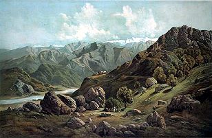
The Sutlej is sometimes known as the Red River. It is the easternmost tributary
Tributary
A tributary or affluent is a stream or river that flows into a main stem river or a lake. A tributary does not flow directly into a sea or ocean...
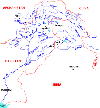
of the Indus River
Indus River
The Indus River is a major river which flows through Pakistan. It also has courses through China and India.Originating in the Tibetan plateau of western China in the vicinity of Lake Mansarovar in Tibet Autonomous Region, the river runs a course through the Ladakh district of Jammu and Kashmir and...
. Its source is near Lake Rakshastal
Lake Rakshastal
Lake Rakshastal is a lake in Tibet, lying close to the west of Lake Manasarovar and Mount Kailash. The Satluj River originates at Rakshastal's northwestern tip. Despite its close proximity to Lake Manasarovar—over the road to Purang County, Lake Rakshastal does not share the lore of worship with...
in Tibet
Tibet
Tibet is a plateau region in Asia, north-east of the Himalayas. It is the traditional homeland of the Tibetan people as well as some other ethnic groups such as Monpas, Qiang, and Lhobas, and is now also inhabited by considerable numbers of Han and Hui people...
, China
People's Republic of China
China , officially the People's Republic of China , is the most populous country in the world, with over 1.3 billion citizens. Located in East Asia, the country covers approximately 9.6 million square kilometres...
, near Mount Kailas, and it flows generally west and southwest entering India through the Shipki La pass in Himachal Pradesh
Himachal Pradesh
Himachal Pradesh is a state in Northern India. It is spread over , and is bordered by the Indian states of Jammu and Kashmir on the north, Punjab on the west and south-west, Haryana and Uttar Pradesh on the south, Uttarakhand on the south-east and by the Tibet Autonomous Region on the east...
. In Pakistan, it waters the ancient and historical former Bahawalpur state. The region to its south and east is arid, and is known as Cholistan a part of Bahawalpur Division. The Sutlej is joined by the Beas River
Beas River
The Beas River is a river in the northern part of India. The river rises in the Himalayas in central Himachal Pradesh, India, and flows for some 470 km to the Sutlej River in the Indian state of Punjab....
in Hari-Ke-Patan, Amritsar
Amritsar
Amritsar is a city in the northern part of India and is the administrative headquarters of Amritsar district in the state of Punjab, India. The 2001 Indian census reported the population of the city to be over 1,500,000, with that of the entire district numbering 3,695,077...
, Punjāb, India
Punjab (India)
Punjab ) is a state in the northwest of the Republic of India, forming part of the larger Punjab region. The state is bordered by the Indian states of Himachal Pradesh to the east, Haryana to the south and southeast and Rajasthan to the southwest as well as the Pakistani province of Punjab to the...
, and continues southwest into Pakistan to unite with the Chenab River
Chenab River
The Chenab River چنRiver' آب) is a major river of Jammu and Kashmir and the Punjab in Pakistan. It forms in the upper Himalayas in the Lahaul and Spiti district of Himachal Pradesh, India, and flows through the Jammu region of Jammu and Kashmir into the plains of the Punjab, Pakistan...
, forming the Panjnad River
Panjnad River
Panjnad River is a river at the extreme end of Bahawalpur district in Punjab, Pakistan. Panjnad River is formed by successive confluence of the five rivers of Punjab, namely Jhelum, Chenab, Ravi, Beas and Sutlej...
near Bahawalpur. The Panjnad joins the Indus River at Mithankot
Mithankot
Mithankot , is located in southern Punjab, Pakistan.- Geography :Mithankot is located on the right bank of the Indus River, only a short distance downstream from its junction with Panjnad River. The latter is formed by successive confluence of the five rivers of Punjab, namely Jhelum, Chenab,...
. Indus then flows through a gorge near Sukkur
Sukkur
Sukkur, or Sakharu , formerly Aror and Bakar, is the third largest city of Sindh province, situated on the west bank of Indus River in Pakistan in Sukkur District. However, the word Sakharu in Sindhi means "superior", which the spelling of the city's name in Sindhi suggests is the origin of the...
, flows through the fertile plains region of Sindh
Sindh
Sindh historically referred to as Ba'ab-ul-Islam , is one of the four provinces of Pakistan and historically is home to the Sindhi people. It is also locally known as the "Mehran". Though Muslims form the largest religious group in Sindh, a good number of Christians, Zoroastrians and Hindus can...
, and terminates in the Arabian Sea
Arabian Sea
The Arabian Sea is a region of the Indian Ocean bounded on the east by India, on the north by Pakistan and Iran, on the west by the Arabian Peninsula, on the south, approximately, by a line between Cape Guardafui in northeastern Somalia and Kanyakumari in India...
near the port city of Karachi
Karachi
Karachi is the largest city, main seaport and the main financial centre of Pakistan, as well as the capital of the province of Sindh. The city has an estimated population of 13 to 15 million, while the total metropolitan area has a population of over 18 million...
in Pakistan.
The waters of the Sutlej are allocated to India under the Indus Waters Treaty
Indus Waters Treaty
The Indus Waters Treaty is a water-sharing treaty between the Republic of India and Islamic Republic Of Pakistan, brokered by the World Bank . The treaty was signed in Karachi on September 19, 1960 by Indian Prime Minister Jawaharlal Nehru and President of Pakistan Mohammad Ayub Khan...
between India and Pakistan, and are mostly diverted to irrigation canals in India. There are several major hydroelectric projects on the Sutlej, for example, the 1,000 MW Bhakra Dam
Bhakra Dam
Bhakra Dam is a concrete gravity dam across the Sutlej River, and is near the border between Punjab and Himachal Pradesh in northern India.The dam, located at a gorge near the upstream Bhakra village in Bilaspur district of Himachal Pradesh, is Asia's second highest at 225.55 m high next to...
, the 1,000 MW Karcham-Wangtoo and the 1,530 MW Nathpa Jhakri Hydroelectric Dam. There has been a proposal to build a 214 kilometres (133 mi) long heavy freight canal, known as the Sutlej-Yamuna Link (SYL), in India to connect the Sutlej and Yamuna
Yamuna
The Yamuna is the largest tributary river of the Ganges in northern India...
rivers. However, the proposal met obstacles and was referred to the Supreme Court.
The Sutlej was known as Śutudri in the Vedic period
Vedic period
The Vedic period was a period in history during which the Vedas, the oldest scriptures of Hinduism, were composed. The time span of the period is uncertain. Philological and linguistic evidence indicates that the Rigveda, the oldest of the Vedas, was composed roughly between 1700–1100 BCE, also...
.
History
The Upper Sutlej Valley was once known as the GarudaGaruda
The Garuda is a large mythical bird or bird-like creature that appears in both Hindu and Buddhist mythology.From an Indian perspective, Garuda is the Hindu name for the constellation Aquila and...
Valley by the Zhang Zhung, the ancient civilization of western Tibet
Tibet
Tibet is a plateau region in Asia, north-east of the Himalayas. It is the traditional homeland of the Tibetan people as well as some other ethnic groups such as Monpas, Qiang, and Lhobas, and is now also inhabited by considerable numbers of Han and Hui people...
. The Garuda Valley was the centre of their empire which stretched many many miles into the nearby Himalayas
Himalayas
The Himalaya Range or Himalaya Mountains Sanskrit: Devanagari: हिमालय, literally "abode of snow"), usually called the Himalayas or Himalaya for short, is a mountain range in Asia, separating the Indian subcontinent from the Tibetan Plateau...
. The Zhang Zhung built a towering palace in the Upper Sutlej Valley called Kyunglung
Kyunglung
Kyunglung or Khyunglung is a village in the Tibet Autonomous Region of China. Kyunglung , the "Silver Palace of Garuda", southwest of Mount Kailash , which is identified with palaces found in the upper Sutlej Valley was the capital city of the ancient kingdom of Zhang Zhung...
, the ruins of which still exist today nearby to the village of Moincer
Moincêr
Moincêr or Mencixiang is a village in the Tibet Autonomous Region of China. It is located along Route G219, close to the Tirthapuri Monastary in the Ngari Region of Western Tibet. The village is located south-west of Mount Kailash ....
, southwest of Mount Kailash (Mount Ti-se)
Eventually the Zhang Zhung were conquered by the Tibetan Empire
Tibetan Empire
The historic name for the Tibetan Empire is different from Tibet's present name.Traditional Tibetan history preserves a lengthy list of rulers, whose exploits become subject to external verification in the Chinese histories by the seventh century. From the 7th to the 11th century a series of...
, which was itself taken over by the Guge
Guge
Guge was an ancient kingdom in Western Tibet. The kingdom was centered in present-day Zanda County, within Ngari Prefecture of Tibet Autonomous Region, China. At various points in history after 10th century AD, the kingdom held sway over a vast area including south-eastern Zanskar, Upper Kinnaur,...
Kingdom. Their kings built another palace, called Tsaparang
Tsaparang
Tsaparang was the capital of the ancient kingdom of Guge in the Garuda Valley, through which the upper Sutlej River flows, in Ngari Prefecture near the border of Ladakh. It is 278 km south-southwest of Ali and 26 km west of the 11th century monastery at Thöling, and not far west of Mount Kailash...
further down the Sutlej, which too remains today in ruins.
Today, the Sutlej Valley is inhabited by nomadic ancestors or the Zhang Zhung who live in tiny villages of as yak
Yak
The yak, Bos grunniens or Bos mutus, is a long-haired bovine found throughout the Himalayan region of south Central Asia, the Tibetan Plateau and as far north as Mongolia and Russia. In addition to a large domestic population, there is a small, vulnerable wild yak population...
herders.
Geology of the Sutlej
The Sutlej, along with all of the Punjab rivers, is thought to have drained east into the Ganges prior to 5 mya.There is substantial geologic evidence to indicate that prior to 1700 BC at the latest, Sutlej was an important tributary of the Ghaggar-Hakra River
Ghaggar-Hakra River
The Ghaggar-Hakra River is an intermittent river in India and Pakistan that flows only during the monsoon season. The river is known as Ghaggar before the Ottu barrage and as the Hakra downstream of the barrage...
(possibly through the Saraswati river
Saraswati River
Saraswati River can refer to:*Sarasvati River*Saraswati River , a distributary of the Hooghly River which was active till around the 16th century AD*Ghaggar-Hakra River...
) rather than the Indus with various authors putting the redirection from 2500-2000 BC. or 5000-3000 BC Geologists believe that tectonic activity
Earthquake
An earthquake is the result of a sudden release of energy in the Earth's crust that creates seismic waves. The seismicity, seismism or seismic activity of an area refers to the frequency, type and size of earthquakes experienced over a period of time...
created elevation changes which redirected the flow of Sutlej from the southeast to the southwest. The mighty Saraswati then began to dry up, causing desertification of Cholistan and the eastern part of the modern state of Sindh
Sindh
Sindh historically referred to as Ba'ab-ul-Islam , is one of the four provinces of Pakistan and historically is home to the Sindhi people. It is also locally known as the "Mehran". Though Muslims form the largest religious group in Sindh, a good number of Christians, Zoroastrians and Hindus can...
. The desertification resulted in abandonment of numerous ancient human settlements along the banks of Saraswati.
There is some evidence that the high rate of erosion caused by the modern Sutlej River has influenced the local faulting and rapidly exhumed rocks above Rampur
Rampur, Himachal Pradesh
Rampur Bushahr is a city and a municipal council in Shimla district in the Indian state of Himachal Pradesh. It is 130 km from Shimla well connected with National Highway which passes through Narkanda .-History:...
. This would be similar to, but on a much smaller scale then, the exhumation of rocks by the Indus River in Nanga Parbat
Nanga Parbat
Nanga Parbat is the ninth highest mountain on Earth, the second highest mountain in Pakistan and among the eight-thousanders with a summit elevation of 8,126 meters...
, Pakistan. The Sutlej river also exposes a doubled inverted metamorphic gradient.
The source of the Sutlej is just west of Mt. Kailash in western Tibet. This is a roadless area, and was first explored by kayak and raft by Russian and German teams in 2004.
The largest modern industrial city along the Sutlej banks is Ludhiana.