The
Himalaya Range or
Himalaya Mountains (icon or h;
SanskritSanskrit , is a historical Indo-Aryan language and the primary liturgical language of Hinduism, Jainism and Buddhism.Buddhism: besides Pali, see Buddhist Hybrid Sanskrit Today, it is listed as one of the 22 scheduled languages of India and is an official language of the state of Uttarakhand...
:
DevanagariDevanagari |deva]]" and "nāgarī" ), also called Nagari , is an abugida alphabet of India and Nepal...
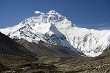
: हिमालय, literally "abode of snow"), usually called the
Himalayas or
Himalaya for short, is a
mountain rangeA mountain range is a single, large mass consisting of a succession of mountains or narrowly spaced mountain ridges, with or without peaks, closely related in position, direction, formation, and age; a component part of a mountain system or of a mountain chain...
in
AsiaAsia is the world's largest and most populous continent, located primarily in the eastern and northern hemispheres. It covers 8.7% of the Earth's total surface area and with approximately 3.879 billion people, it hosts 60% of the world's current human population...
, separating the
Indian subcontinentThe Indian subcontinent, also Indian Subcontinent, Indo-Pak Subcontinent or South Asian Subcontinent is a region of the Asian continent on the Indian tectonic plate from the Hindu Kush or Hindu Koh, Himalayas and including the Kuen Lun and Karakoram ranges, forming a land mass which extends...
from the
Tibetan PlateauThe Tibetan Plateau , also known as the Qinghai–Tibetan Plateau is a vast, elevated plateau in Central Asia covering most of the Tibet Autonomous Region and Qinghai, in addition to smaller portions of western Sichuan, southwestern Gansu, and northern Yunnan in Western China and Ladakh in...
. By extension, it is also the name of a massive mountain system that includes the
KarakoramThe Karakoram, or Karakorum , is a large mountain range spanning the borders between Pakistan, India and China, located in the regions of Gilgit-Baltistan , Ladakh , and Xinjiang region,...
, the
Hindu KushThe Hindu Kush is an mountain range that stretches between central Afghanistan and northern Pakistan. The highest point in the Hindu Kush is Tirich Mir in the Chitral region of Khyber-Pakhtunkhwa, Pakistan.It is the westernmost extension of the Pamir Mountains, the Karakoram Range, and is a...
, and other, lesser, ranges that extend out from the
Pamir KnotThe Pamir Mountains are a mountain range in Central Asia formed by the junction or knot of the Himalayas, Tian Shan, Karakoram, Kunlun, and Hindu Kush ranges. They are among the world’s highest mountains and since Victorian times they have been known as the "Roof of the World" a probable...
.
Together, the Himalayan mountain system is the world's highest, and home to the world's highest peaks, the
Eight-thousanderThe eight-thousanders are the fourteen independent mountains on Earth that are more than high above sea level. They are all located in the Himalayan and Karakoram mountain ranges in Asia....
s, which include
Mount EverestMount Everest is the world's highest mountain, with a peak at above sea level. It is located in the Mahalangur section of the Himalayas. The international boundary runs across the precise summit point...
and
K2K2 is the second-highest mountain on Earth, after Mount Everest...
. To comprehend the enormous scale of this mountain range, consider that
AconcaguaAconcagua is the highest mountain in the Americas at . It is located in the Andes mountain range, in the Argentine province of Mendoza and it lies west by north of its capital, the city of Mendoza. The summit is also located about 5 kilometres from San Juan Province and 15 kilometres from the...
, in the
AndesThe Andes is the world's longest continental mountain range. It is a continual range of highlands along the western coast of South America. This range is about long, about to wide , and of an average height of about .Along its length, the Andes is split into several ranges, which are separated...
, at 6962 metres (22,841 ft) is the highest peak outside Asia, whereas the Himalayan system includes
over 100 mountains exceeding 7200 m (23,622 ft).
The main Himalayan range runs west to east, from the Indus river valley to the Brahmaputra river valley, forming an arc 2400 km (1,491.3 mi) long, which varies in width from 400 km (248.5 mi) in the western Kashmir-
XinjiangXinjiang is an autonomous region of the People's Republic of China. It is the largest Chinese administrative division and spans over 1.6 million km2...
region to 150 km (93.2 mi) in the eastern
TibetThe Tibet Autonomous Region , Tibet or Xizang for short, also called the Xizang Autonomous Region is a province-level autonomous region of the People's Republic of China , created in 1965....
-
Arunachal PradeshArunachal Pradesh is a state of India, located in the far northeast. It borders the states of Assam and Nagaland to the south, and shares international borders with Burma in the east, Bhutan in the west, and the People's Republic of China in the north. The majority of the territory is claimed by...
region. The range consists of three coextensive sub-ranges, with the northernmost, and highest, known as the Great or Inner Himalayas.
Some of the world's major river systems arise in the Himalayas, and their combined
drainage basinA drainage basin is an extent or an area of land where surface water from rain and melting snow or ice converges to a single point, usually the exit of the basin, where the waters join another waterbody, such as a river, lake, reservoir, estuary, wetland, sea, or ocean...
is home to some 3 billion people (almost half of Earth's population) in 18 countries.
The Himalayas have profoundly shaped the cultures of
South AsiaSouth Asia, also known as Southern Asia, is the southern region of the Asian continent, which comprises the sub-Himalayan countries and, for some authorities , also includes the adjoining countries to the west and the east...
; many Himalayan peaks are sacred in
HinduismHinduism is the predominant and indigenous religious tradition of the Indian Subcontinent. Hinduism is known to its followers as , amongst many other expressions...
,
BuddhismBuddhism is a religion and philosophy encompassing a variety of traditions, beliefs and practices, largely based on teachings attributed to Siddhartha Gautama, commonly known as the Buddha . The Buddha lived and taught in the northeastern Indian subcontinent some time between the 6th and 4th...
and
SikhismSikhism is a monotheistic religion founded during the 15th century in the Punjab region, by Guru Nanak Dev and continued to progress with ten successive Sikh Gurus . It is the fifth-largest organized religion in the world and one of the fastest-growing...
.
Geologically, the origin of the Himalayas is the impact of the Indian tectonic plate traveling northward at 15 cm per year to impact the Eurasian continent, about 40-50 million years ago. The formation of the Himalayan arc resulted since the lighter rock of the seabeds of that time were easily uplifted into mountains. An often-cited fact used to illustrate this process is that the summit of Mount Everest is made of marine
limestoneLimestone is a sedimentary rock composed largely of the minerals calcite and aragonite, which are different crystal forms of calcium carbonate . Many limestones are composed from skeletal fragments of marine organisms such as coral or foraminifera....
.
Ecology
The flora and fauna of the Himalayas vary with climate, rainfall, altitude, and soils. The climate ranges from tropical at the base of the mountains to permanent ice and snow at the highest elevations. The amount of yearly rainfall increases from west to east along the front of the range. This diversity of climate, altitude, rainfall and soil conditions generates a variety of distinct plant and animal communities. In fact the extrema of high altitude (low atmospheric pressure) and very cold at the most elevated reaches allow
extremophileAn extremophile is an organism that thrives in physically or geochemically extreme conditions that are detrimental to most life on Earth. In contrast, organisms that live in more moderate environments may be termed mesophiles or neutrophiles...
organisms to survive.
Lowland forests
On the
Indo-Gangetic plainThe northern Plains also known as the Indo - Gangetic Plain and The North Indian River Plain is a large and fertile plain encompassing most of northern and eastern India, the most populous parts of Pakistan, parts of southern Nepal and virtually all of Bangladesh...
at the base of the mountains, an
alluvial plainAn alluvial plain is a relatively flat landform created by the deposition of sediment over a long period of time by one or more rivers coming from highland regions, from which alluvial soil forms...
drained by the Indus and Ganges-Brahmaputra river systems, vegetation varies from west to east with rainfall. The
xericDeserts and xeric shrublands is a biome characterized by, relating to, or requiring only a small amount of moisture.-Definition and occurrence:...
Northwestern thorn scrub forestsThe Northwestern thorn scrub forests are a xeric shrubland ecoregion of Pakistan and northwestern India, a region of extreme temperatures and a very climate that was once covered in deciduous forest.-Location and description:...
occupy the plains of Pakistan and the Indian Punjab. Further east lie the
Upper Gangetic plains moist deciduous forestsThe Upper Gangetic Plains moist deciduous forests is a tropical moist broadleaf forest ecoregion of northern India. It lies on the alluvial plain of the Ganges and Yamuna rivers, with an area of , covering most of the state of Uttar Pradesh and adjacent portions of Uttarakhand, Haryana, Madhya...
of
UttarakhandUttarakhand , formerly Uttaranchal, is a state in the northern part of India. It is often referred to as the Land of Gods due to the many holy Hindu temples and cities found throughout the state, some of which are among Hinduism's most spiritual and auspicious places of pilgrimage and worship...
and
Uttar PradeshUttar Pradesh abbreviation U.P. , is a state located in the northern part of India. With a population of over 200 million people, it is India's most populous state, as well as the world's most populous sub-national entity...
and
Lower Gangetic plains moist deciduous forestsThe Lower Gangetic plains moist deciduous forests is a tropical moist broadleaf forest ecoregion of Bangladesh and eastern India. The ecoregion covers an area of , covering most of Bangladesh and the Indian states of West Bengal, Bihar, and Tripura, and extending into adjacent portions of Assam,...
of
BiharBihar is a state in eastern India. It is the 12th largest state in terms of geographical size at and 3rd largest by population. Almost 58% of Biharis are below the age of 25, which is the highest proportion in India....
and
West BengalWest Bengal is a state in the eastern region of India and is the nation's fourth-most populous. It is also the seventh-most populous sub-national entity in the world, with over 91 million inhabitants. A major agricultural producer, West Bengal is the sixth-largest contributor to India's GDP...
. These are monsoon forests, with drought-deciduous trees that lose their leaves during the dry season. The moister
Brahmaputra Valley semi-evergreen forestsThe Brahmaputra Valley semi-evergreen forests is a tropical moist broadleaf forest ecoregion of eastern India and southern Bhutan.-Location and description:...
occupy the plains of
AssamAssam , also, rarely, Assam Valley and formerly the Assam Province , is a northeastern state of India and is one of the most culturally and geographically distinct regions of the country...
.
The Terai belt
Above the alluvial plain lies the
TeraiThe Terai is a belt of marshy grasslands, savannas, and forests located south of the outer foothills of the Himalaya, the Siwalik Hills, and north of the Indo-Gangetic Plain of the Ganges, Brahmaputra and their tributaries. The Terai belongs to the Terai-Duar savanna and grasslands ecoregion...
strip, a seasonally marshy zone of sand and clay soils. The Terai has higher rainfall than the plains, and the downward-rushing rivers of the Himalaya slow down and spread out in the flatter Terai zone, depositing fertile silt during the monsoon season and receding in the dry season. The Terai has a high water table due to groundwater percolating down from the adjacent zone. The central part of the Terai belt is occupied by the
Terai-Duar savanna and grasslandsThe Terai-Duar savanna and grasslands is a narrow lowland ecoregion at the base of the Himalayas, about wide and a continuation of the Gangetic Plain colloquially called Terai in the Ganges Basin east to Nepal, then Dooars in West Bengal, Bangladesh, Bhutan and Assam east to the Brahmaputra River...
, a mosaic of grasslands, savannas, deciduous and evergreen forests that includes some of the world's tallest grasslands. The grasslands of the Terai belt are home to the
Indian rhinocerosThe Indian Rhinoceros is also called Greater One-horned Rhinoceros and Asian One-horned Rhinoceros and belongs to the Rhinocerotidae family...
(Rhinoceros unicornis).
Bhabhar belt
Above the Terai belt is an upland zone known as the
BhabharBhabhar is the region south of the Lower Himalayas and the Siwalik Hills It is the alluvial apron of sediments washed down from the Siwaliks along the northern edge of the Indo-Gangetic Plain.-Etymology:...
, a zone of porous and rocky soils made up of debris washed down from the higher ranges. The Bhabhar and the lower Shiwalik ranges have a subtropical climate. The
Himalayan subtropical pine forestsThe Himalayan subtropical pine forests are a large subtropical coniferous forest ecoregion covering portions of Bhutan, India, Nepal, and Pakistan....
occupy the western end of the subtropical belt, with forests dominated by
Chir PineThe Chir Pine, Pinus roxburghii, named after William Roxburgh, is a pine native to the Himalaya.The range extends from northern Pakistan , across northern India and Nepal to Bhutan.It generally occurs at lower altitudes than other pines in the Himalaya, from...
(Pinus roxburghii). The central part of the range is home to the
Himalayan subtropical broadleaf forestsThe Himalayan subtropical broadleaf forests is an ecoregion that extends from the middle hills of central Nepal through Darjeeling into Bhutan and also into the Indian State of Uttar Pradesh...
, dominated by the sal tree
(Shorea robusta). They are at the foot of the Himalayas where the Himalayan streams descend on to the plains.
Shiwalik Hills
Also called Churia or Margalla Hills, Sivalik Hills is an intermittent outermost range of foothills extending across the Himalayan region through
PakistanPakistan , officially the Islamic Republic of Pakistan is a sovereign state in South Asia. It has a coastline along the Arabian Sea and the Gulf of Oman in the south and is bordered by Afghanistan and Iran in the west, India in the east and China in the far northeast. In the north, Tajikistan...
,
IndiaIndia , officially the Republic of India , is a country in South Asia. It is the seventh-largest country by geographical area, the second-most populous country with over 1.2 billion people, and the most populous democracy in the world...
,
NepalNepal , officially the Federal Democratic Republic of Nepal, is a landlocked sovereign state located in South Asia. It is located in the Himalayas and bordered to the north by the People's Republic of China, and to the south, east, and west by the Republic of India...
and
BhutanBhutan , officially the Kingdom of Bhutan, is a landlocked state in South Asia, located at the eastern end of the Himalayas and bordered to the south, east and west by the Republic of India and to the north by the People's Republic of China...
. This region consists of many sub-ranges. Summits are generally 600 to 1200 m (1,968.5 to 3,937 ft). Steeper southern slopes form along a fault zone called
Himalayan Frontal Thrust (HFT); northern slopes are gentler. Permeable conglomerates and other rocks allow rainwater to percolate downslope into the Bhabhar and Terai, supporting only scrubby forests upslope. The Himalayan subtropical pine and broadleaf forests continue here.
Inner Terai or Dun Valleys
The
Inner Terai valleysThe Inner Terai Valleys or Bhitri tarai are various elongated valleys in Nepal situated between the Himalayan foothills, the 600–900 m high Siwalik or Churia Range and the 2,000-3,000 m high Mahabharat Range further north. Major examples are the Chitwan Valley southwest of Kathmandu and the...
are open valleys north of Shiwalik Hills or nestled between Shiwalik subranges. Examples include Dehra Dun in India and Chitwan in Nepal. Himalayan subtropical broadleaf forests grow here.
Lesser Himalaya
Also called Mahabharat Range, the Lesser Himalayas is a prominent range 2000 to 3000 m (6,561.7 to 9,842.5 ft) high formed along the
Main Boundary Thrust fault zone, with a steep southern face and gentler northern slopes. They are nearly continuous except for river gorges, where rivers from to the north gather like candelabra in a handful of places to break through the range.
At these elevations and above the
biogeographyBiogeography is the study of the distribution of species , organisms, and ecosystems in space and through geological time. Organisms and biological communities vary in a highly regular fashion along geographic gradients of latitude, elevation, isolation and habitat area...
of the Himalayas is generally divided by the
Kali Gandaki GorgeThe Kali Gandaki Gorge or Andha Galchi is the gorge of the Kali Gandaki in the Himalayas in Nepal, by some measures the deepest gorge in the world....
in central Nepal, one of the deepest canyons in the world.
At the middle elevations of the range, the subtropical forests yield to a belt of
temperate broadleaf and mixed forestsMixed forests are a temperate and humid biome. The typical structure of these forests includes four layers. The uppermost layer is the canopy composed of tall mature trees ranging from 33 to 66 m high. Below the canopy is the three-layered, shade-tolerant understory that is roughly 9 to...
growing between 1500 and 3000 m (4,921.3 and 9,842.5 ft), with the
western Himalayan broadleaf forestsThe Western Himalayan broadleaf forests is a temperate broadleaf and mixed forest ecoregion which is found in the middle elevations of the western Himalayas, including parts of Nepal, India, and Pakistan.-Setting:...
to the west of the Gandaki River, and the
eastern Himalayan broadleaf forestsThe Eastern Himalayan broadleaf forests is a temperate broadleaf forest ecoregion found in the middle elevations of the eastern Himalayas, including parts of Nepal, India, and Bhutan...
to the east. The western broadleaf forests stretch from the
Kashmir Valley, across Himachal Pradesh and Uttarakhand, and through western Nepal. The eastern broadleaf forests stretch across eastern Nepal, through Sikkim and Bhutan, and through much of Arunachal Pradesh.
Midlands
This 'hilly' region (
Pahad), averaging about 1000 metres (3,280.8 ft) immediately north of the Mahabharat Range, rises over about 100 kilometres (328,084 ft) to about 4000 metres (13,123.4 ft) at the
Main Central Thrust fault zone, where the Greater Himalaya begin.
Above the broadleaf forests, between 3000 and 4000 m (9,842.5 and 13,123.4 ft), are
temperate coniferous forestsTemperate coniferous forest is a terrestrial biome found in temperate regions of the world with warm summers and cool winters and adequate rainfall to sustain a forest. In most temperate coniferous forests, evergreen conifers predominate, while some are a mix of conifers and broadleaf evergreen...
, likewise split by the Gandaki River. The
western Himalayan subalpine conifer forestsThe Western Himalayan subalpine conifer forests is a temperate coniferous forests ecoregion of the middle and upper elevations of the western Middle Himalayas of Nepal, India, and Pakistan.-Setting:...
are found below treeline in northern Pakistan, Jammu and Kashmir, Himachal Pradesh, Uttarakhand, and western Nepal. The
eastern Himalayan subalpine conifer forestsThe Eastern Himalayan subalpine conifer forests is a temperate coniferous forests ecoregion which is found in the middle and upper elevations of the eastern Middle Himalayas, in western Nepal, Bhutan and northern Indian states including Arunachal Pradesh....
are found in eastern Nepal, Sikkim, Bhutan, and Arunachal Pradesh. Along the border between Arunachal Pradesh and Tibet, the eastern subalpine conifer forests mix with the
northeastern Himalayan subalpine conifer forestsThe Northeastern Himalayan subalpine conifer forests is a temperate coniferous forests ecoregion of the middle to upper elevations of the eastern Himalayas. It occurs in southeastern Tibet and northeastern India.-Setting:...
. East Himalayan Fir, West Himalayan Spruce, and Himalayan Hemlock are some important trees of these forests.
RhododendronRhododendron is a genus of over 1 000 species of woody plants in the heath family, most with showy flowers...
s are exceptionally diverse here, with over 60 species recorded in the northeastern Himalayan subalpine conifer forests.
Greater Himalaya
North of the Main Central Thrust, the highest ranges rise abruptly as much as 4000 metres (13,123.4 ft) into the realm of perpetual snow and ice. As the Himalayan system becomes wider from east to west, the number of parallel high ranges increases. For example, the Kagmara and Kanjiroba ranges both reach well over 6000 metres (19,685 ft) north of the
DhaulagiriDhaulagiri is Earth's seventh highest mountain at ; one of fourteen over eight thousand metres. Dhaulagiri was first climbed May 13, 1960 by a Swiss/Austrian expedition....
Himalaya in central
NepalNepal , officially the Federal Democratic Republic of Nepal, is a landlocked sovereign state located in South Asia. It is located in the Himalayas and bordered to the north by the People's Republic of China, and to the south, east, and west by the Republic of India...
.
Montane grasslands and shrublandsMontane grasslands and shrublands is a biome defined by the World Wildlife Fund. The biome includes high altitude grasslands and shrublands around the world....
grow above treeline. The
northwestern Himalayan alpine shrub and meadowsThe Northwestern Himalayan alpine shrub and meadows is a montane grasslands and shrublands ecoregion of the elevations of the northwestern Himalaya of China, India, and Pakistan.-Setting:...
are found in the high elevations of northern Pakistan, Jammu and Kashmir, and Himachal Pradesh. To the east, the
western Himalayan alpine shrub and meadowsThe Western Himalayan alpine shrub and meadows is an montane grasslands and shrublands ecoregion of Nepal, India, and Tibet, which lies between the tree line and snow line in the western portion of the Himalaya Range.-Setting:...
cover extensive areas along the Tibetan border with Uttarakhand and western Nepal. The
eastern Himalayan alpine shrub and meadowsThe Eastern Himalayan alpine shrub and meadows is a montane grasslands and shrublands ecoregion of Bhutan, China, India, Myanmar, and Nepal, which lies between the tree line and snow line in the eastern portion of the Himalaya Range.-Setting:...
grow above the eastern and northeastern subalpine conifer forests, along the Tibetan border with eastern Nepal, Sikkim, Bhutan, and Arunachal Pradesh. The shrublands are composed of
juniperJunipers are coniferous plants in the genus Juniperus of the cypress family Cupressaceae. Depending on taxonomic viewpoint, there are between 50-67 species of juniper, widely distributed throughout the northern hemisphere, from the Arctic, south to tropical Africa in the Old World, and to the...
s as well as a wide variety of
rhododendronRhododendron is a genus of over 1 000 species of woody plants in the heath family, most with showy flowers...
s. They also possess a remarkable variety of wildflowers: Valley of Flowers National Park in the western Himalayan alpine shrub and meadows contains hundreds of species. The upper limit of the grasslands increases from west to east, rising from 3500 metres (11,482.9 ft) to 5500 metres (18,044.6 ft). The grasslands are the summer habitat of the endangered
snow leopardThe snow leopard is a moderately large cat native to the mountain ranges of South Asia and Central Asia...
(Uncia uncia).
Trans-Himalaya
The watershed between rivers flowing south into the Ganges or Indus and rivers flowing north into the Brahmaputra or mainstem Indus that flow around the ends of the entire range often follows somewhat lower, less rugged mountains tens of kilometers north of the highest ranges. South-flowing rivers form valleys in this region, often semi-arid due to rainshadow effects. These valleys hold some of the highest permanent villages on earth.
Origins and growth
The Himalayas are among the youngest mountain ranges on the planet and consist mostly of uplifted sedimentary and
metamorphic rockMetamorphic rock is the transformation of an existing rock type, the protolith, in a process called metamorphism, which means "change in form". The protolith is subjected to heat and pressure causing profound physical and/or chemical change...
. According to the modern theory of
plate tectonicsPlate tectonics is a scientific theory that describes the large scale motions of Earth's lithosphere...
, their formation is a result of a
continental collisionContinental collision is a phenomenon of the plate tectonics of Earth that occurs at convergent boundaries. Continental collision is a variation on the fundamental process of subduction, whereby the subduction zone is destroyed, mountains produced, and two continents sutured together...
or
orogenyOrogeny refers to forces and events leading to a severe structural deformation of the Earth's crust due to the engagement of tectonic plates. Response to such engagement results in the formation of long tracts of highly deformed rock called orogens or orogenic belts...
along the
convergent boundaryIn plate tectonics, a convergent boundary, also known as a destructive plate boundary , is an actively deforming region where two tectonic plates or fragments of lithosphere move toward one another and collide...
between the
Indo-Australian PlateThe Indo-Australian Plate is a major tectonic plate that includes the continent of Australia and surrounding ocean, and extends northwest to include the Indian subcontinent and adjacent waters...
and the
Eurasian PlateThe Eurasian Plate is a tectonic plate which includes most of the continent of Eurasia , with the notable exceptions of the Indian subcontinent, the Arabian subcontinent, and the area east of the Chersky Range in East Siberia...
. This is referred to as a
fold mountainFold mountains are mountains formed mainly by the effects of folding on layers within the upper part of the Earth's crust. In the time before either plate tectonic theory developed, or the internal architecture of thrust belts became well understood, the term was used for most mountain belts, such...
.
The collision began in the
Upper CretaceousThe Cretaceous , derived from the Latin "creta" , usually abbreviated K for its German translation Kreide , is a geologic period and system from circa to million years ago. In the geologic timescale, the Cretaceous follows the Jurassic period and is followed by the Paleogene period of the...
period about 70 million years ago, when the north-moving
Indo-Australian PlateThe Indo-Australian Plate is a major tectonic plate that includes the continent of Australia and surrounding ocean, and extends northwest to include the Indian subcontinent and adjacent waters...
, moving at about 15 cm per year, collided with the
Eurasian PlateThe Eurasian Plate is a tectonic plate which includes most of the continent of Eurasia , with the notable exceptions of the Indian subcontinent, the Arabian subcontinent, and the area east of the Chersky Range in East Siberia...
. About 50 million years ago, this fast moving Indo-Australian plate had completely closed the
Tethys OceanThe Tethys Ocean was an ocean that existed between the continents of Gondwana and Laurasia during the Mesozoic era before the opening of the Indian Ocean.-Modern theory:...
, the existence of which has been determined by
sedimentary rockSedimentary rock are types of rock that are formed by the deposition of material at the Earth's surface and within bodies of water. Sedimentation is the collective name for processes that cause mineral and/or organic particles to settle and accumulate or minerals to precipitate from a solution....
s settled on the ocean floor, and the
volcano2. Bedrock3. Conduit 4. Base5. Sill6. Dike7. Layers of ash emitted by the volcano8. Flank| 9. Layers of lava emitted by the volcano10. Throat11. Parasitic cone12. Lava flow13. Vent14. Crater15...
es that fringed its edges. Since these sediments were light, they crumpled into mountain ranges rather than sinking to the floor. The Indo-Australian plate continues to be driven horizontally below the
Tibetan plateauThe Tibetan Plateau , also known as the Qinghai–Tibetan Plateau is a vast, elevated plateau in Central Asia covering most of the Tibet Autonomous Region and Qinghai, in addition to smaller portions of western Sichuan, southwestern Gansu, and northern Yunnan in Western China and Ladakh in...
, which forces the plateau to move upwards. The
Arakan YomaThe Arakan Mountains is a mountain range in western Burma , between the coast of Rakhine State and the Central Burma Basin, in which flows the Irrawaddy River...
highlands in
MyanmarBurma , officially the Republic of the Union of Myanmar , is a country in Southeast Asia. Burma is bordered by China on the northeast, Laos on the east, Thailand on the southeast, Bangladesh on the west, India on the northwest, the Bay of Bengal to the southwest, and the Andaman Sea on the south....
and the
Andaman and Nicobar Islands in the
Bay of BengalThe Bay of Bengal , the largest bay in the world, forms the northeastern part of the Indian Ocean. It resembles a triangle in shape, and is bordered mostly by the Eastern Coast of India, southern coast of Bangladesh and Sri Lanka to the west and Burma and the Andaman and Nicobar Islands to the...
were also formed as a result of this collision.
The Indo-Australian plate is still moving at 67 mm per year, and over the next 10 million years it will travel about 1,500 km into Asia. About 20 mm per year of the India-Asia convergence is absorbed by
thrustingA thrust fault is a type of fault, or break in the Earth's crust across which there has been relative movement, in which rocks of lower stratigraphic position are pushed up and over higher strata. They are often recognized because they place older rocks above younger...
along the Himalaya southern front. This leads to the Himalayas rising by about 5 mm per year, making them geologically active. The movement of the Indian plate into the Asian plate also makes this region seismically active, leading to
earthquakeAn earthquake is the result of a sudden release of energy in the Earth's crust that creates seismic waves. The seismicity, seismism or seismic activity of an area refers to the frequency, type and size of earthquakes experienced over a period of time...
s from time to time.
Glaciers and river systems
The Himalayan range encompasses about 15,000
glacierA glacier is a large persistent body of ice that forms where the accumulation of snow exceeds its ablation over many years, often centuries. At least 0.1 km² in area and 50 m thick, but often much larger, a glacier slowly deforms and flows due to stresses induced by its weight...
s, which store about 12,000 km
3 of freshwater. The 70 km-long
Siachen GlacierThe Siachen Glacier is located in the eastern Karakoram range in the Himalaya Mountains at about , just east of the Line of Control between India-Pakistan. India controls all of the Siachen Glacier itself, including all tributary glaciers. At long, it is the longest glacier in the Karakoram and...
at the India-Pakistan border is the second longest glacier in the world outside the polar region. Some of the other more famous glaciers include the
GangotriGangotri Glacier is located in Uttarkashi District, Uttarakhand, India in a region bordering China. This glacier, source of the Ganges, is one of the largest in the Himalayas with an estimated volume of over 27 cubic kilometers. The glacier is about 30 kilometres long and 2 to 4 km wide...
and
YamunotriYamunotri is the source of the Yamuna River and the seat of the Goddess Yamuna in Hinduism. It is situated at an altitude of in the Garhwal Himalayas and located approximately North of Uttarkashi, the headquarters of the Uttarkashi district in the Garhwal Division of Uttarakhand, India...
(
UttarakhandUttarakhand , formerly Uttaranchal, is a state in the northern part of India. It is often referred to as the Land of Gods due to the many holy Hindu temples and cities found throughout the state, some of which are among Hinduism's most spiritual and auspicious places of pilgrimage and worship...
), Nubra,
BiafoThe Biafo Glacier is a long glacier in the Karakoram Mountains of the Northern Areas, Pakistan which meets the long Hispar Glacier at an altitude of at Hispar La to create the world's longest glacial system outside the polar regions. This highway of ice connects two ancient mountain kingdoms,...
and
BaltoroThe Baltoro Glacier, at 62 kilometers long, is one of the longest glaciers outside the polar regions. It is located in Baltistan, in the Gilgit-Baltistan region of Pakistan, and runs through part of the Karakoram mountain range. The Baltoro Muztagh lies to the north and east of the glacier, while...
(
KarakoramThe Karakoram, or Karakorum , is a large mountain range spanning the borders between Pakistan, India and China, located in the regions of Gilgit-Baltistan , Ladakh , and Xinjiang region,...
region),
ZemuZemu Glacier is the largest glacier in the Eastern Himalaya.It is about in length and found at the base of the Kangchenjunga in the Sikkim Himalaya, India. It may be one of the sources for the Teesta River.-Purported Yeti Sighting:...
(
SikkimSikkim is a landlocked Indian state nestled in the Himalayan mountains...
) and
KhumbuKhumbu is located in northeastern Nepal on the Nepalese side of Mount Everest. It is part of the Solukhumbu District, which in turn is part of the Sagarmatha Zone. Khumbu is one of three subregions of the main Khambu and Sherpa settlement of the Himalaya, the other two being Solu and Pharak...
glaciers (
Mount EverestMount Everest is the world's highest mountain, with a peak at above sea level. It is located in the Mahalangur section of the Himalayas. The international boundary runs across the precise summit point...
region).
The higher regions of the Himalayas are snowbound throughout the year, in spite of their proximity to the
tropicsThe tropics is a region of the Earth surrounding the Equator. It is limited in latitude by the Tropic of Cancer in the northern hemisphere at approximately N and the Tropic of Capricorn in the southern hemisphere at S; these latitudes correspond to the axial tilt of the Earth...
, and they form the sources for several large
perennial riversA perennial stream or perennial river is a stream or river that has continuous flow in parts of its bed all year round during years of normal rainfall. "Perennial" streams are contrasted with "intermittent" streams which normally cease flowing for weeks or months each year, and with "ephemeral"...
, most of which combine into two large river systems:
- The western rivers combine into the Indus Basin, of which the Indus River
The Indus River is a major river which flows through Pakistan. It also has courses through China and India.Originating in the Tibetan plateau of western China in the vicinity of Lake Mansarovar in Tibet Autonomous Region, the river runs a course through the Ladakh district of Jammu and Kashmir and...
is the largest. The Indus begins in Tibet at the confluence of Sengge and Gar rivers and flows southwest through IndiaIndia , officially the Republic of India , is a country in South Asia. It is the seventh-largest country by geographical area, the second-most populous country with over 1.2 billion people, and the most populous democracy in the world...
and then through PakistanPakistan , officially the Islamic Republic of Pakistan is a sovereign state in South Asia. It has a coastline along the Arabian Sea and the Gulf of Oman in the south and is bordered by Afghanistan and Iran in the west, India in the east and China in the far northeast. In the north, Tajikistan...
to the Arabian SeaThe Arabian Sea is a region of the Indian Ocean bounded on the east by India, on the north by Pakistan and Iran, on the west by the Arabian Peninsula, on the south, approximately, by a line between Cape Guardafui in northeastern Somalia and Kanyakumari in India...
. It is fed by the JhelumJehlum River or Jhelum River , ) is a river that flows in India and Pakistan. It is the largest and most western of the five rivers of Punjab, and passes through Jhelum District...
, the Chenab, the RaviThe Ravi is a trans-boundary river flowing through Northwestern India and eastern Pakistan. It is one of the six rivers of the Indus System in Punjab region ....
, the BeasThe Beas River is a river in the northern part of India. The river rises in the Himalayas in central Himachal Pradesh, India, and flows for some 470 km to the Sutlej River in the Indian state of Punjab....
, and the SutlejThe Sutlej River is the longest of the five rivers that flow through the historic crossroad region of Punjab in northern India and Pakistan. It is located north of the Vindhya Range, south of the Hindu Kush segment of the Himalayas, and east of the Central Sulaiman Range in Pakistan.The Sutlej...
rivers, among others.
- Most of the other Himalayan rivers drain the Ganges-Brahmaputra Basin. Its two main rivers are the Ganges
The Ganges or Ganga, , is a trans-boundary river of India and Bangladesh. The river rises in the western Himalayas in the Indian state of Uttarakhand, and flows south and east through the Gangetic Plain of North India into Bangladesh, where it empties into the Bay of Bengal. By discharge it...
and the Brahmaputra and the YamunaThe Yamuna is the largest tributary river of the Ganges in northern India...
, among other tributaries. The Brahmaputra originates as the Yarlung Tsangpo River in western Tibet, and flows east through TibetTibet is a plateau region in Asia, north-east of the Himalayas. It is the traditional homeland of the Tibetan people as well as some other ethnic groups such as Monpas, Qiang, and Lhobas, and is now also inhabited by considerable numbers of Han and Hui people...
and west through the plains of AssamAssam , also, rarely, Assam Valley and formerly the Assam Province , is a northeastern state of India and is one of the most culturally and geographically distinct regions of the country...
. The Ganges and the Brahmaputra meet in BangladeshBangladesh , officially the People's Republic of Bangladesh is a sovereign state located in South Asia. It is bordered by India on all sides except for a small border with Burma to the far southeast and by the Bay of Bengal to the south...
, and drain into the Bay of BengalThe Bay of Bengal , the largest bay in the world, forms the northeastern part of the Indian Ocean. It resembles a triangle in shape, and is bordered mostly by the Eastern Coast of India, southern coast of Bangladesh and Sri Lanka to the west and Burma and the Andaman and Nicobar Islands to the...
through the world's largest river deltaA delta is a landform that is formed at the mouth of a river where that river flows into an ocean, sea, estuary, lake, reservoir, flat arid area, or another river. Deltas are formed from the deposition of the sediment carried by the river as the flow leaves the mouth of the river...
.
The eastern-most Himalayan rivers feed the
Ayeyarwady RiverThe Irrawaddy River or Ayeyarwady River is a river that flows from north to south through Burma . It is the country's largest river and most important commercial waterway. Originating from the confluence of the N'mai and Mali rivers, it flows relatively straight North-South before emptying through...
, which originates in eastern Tibet and flows south through
MyanmarBurma , officially the Republic of the Union of Myanmar , is a country in Southeast Asia. Burma is bordered by China on the northeast, Laos on the east, Thailand on the southeast, Bangladesh on the west, India on the northwest, the Bay of Bengal to the southwest, and the Andaman Sea on the south....
to drain into the
Andaman SeaThe Andaman Sea or Burma Sea is a body of water to the southeast of the Bay of Bengal, south of Burma, west of Thailand and east of the Andaman Islands, India; it is part of the Indian Ocean....
.
The Salween,
MekongThe Mekong is a river that runs through China, Burma, Laos, Thailand, Cambodia and Vietnam. It is the world's 10th-longest river and the 7th-longest in Asia. Its estimated length is , and it drains an area of , discharging of water annually....
,
YangtzeThe Yangtze, Yangzi or Cháng Jiāng is the longest river in Asia, and the third-longest in the world. It flows for from the glaciers on the Tibetan Plateau in Qinghai eastward across southwest, central and eastern China before emptying into the East China Sea at Shanghai. It is also one of the...
and the Huang He (Yellow River) all originate from parts of the
Tibetan plateauThe Tibetan Plateau , also known as the Qinghai–Tibetan Plateau is a vast, elevated plateau in Central Asia covering most of the Tibet Autonomous Region and Qinghai, in addition to smaller portions of western Sichuan, southwestern Gansu, and northern Yunnan in Western China and Ladakh in...
that are geologically distinct from the Himalaya mountains, and are therefore not considered true Himalayan rivers. Some geologists refer to all the rivers collectively as the
circum-Himalayan rivers.
In recent years, scientists have monitored a notable increase in the rate of
glacier retreatThe retreat of glaciers since 1850 affects the availability of fresh water for irrigation and domestic use, mountain recreation, animals and plants that depend on glacier-melt, and in the longer term, the level of the oceans...
across the region as a result of global
climate changeClimate change is a significant and lasting change in the statistical distribution of weather patterns over periods ranging from decades to millions of years. It may be a change in average weather conditions or the distribution of events around that average...
. Although the effect of this will not be known for many years, it potentially could mean disaster for the hundreds of millions of people who rely on the
glacierA glacier is a large persistent body of ice that forms where the accumulation of snow exceeds its ablation over many years, often centuries. At least 0.1 km² in area and 50 m thick, but often much larger, a glacier slowly deforms and flows due to stresses induced by its weight...
s to feed the rivers of northern
IndiaIndia , officially the Republic of India , is a country in South Asia. It is the seventh-largest country by geographical area, the second-most populous country with over 1.2 billion people, and the most populous democracy in the world...
during the dry seasons.
Lakes
The Himalaya region is dotted with hundreds of lakes. Most lakes are found at altitudes of less than 5,000 m, with the size of the lakes diminishing with altitude.
Pangong TsoPangong Tso is an endorheic lake in the Himalayas situated at a height of about . It is long and extends from India to Tibet. 60% of the length of the lake lies in China. The lake is wide at its broadest point...
, which is spread across the border between India and China, and Yamdrok Tso, located in central Tibet, are amongst the largest with surface areas of 700 km², and 638 km², respectively. Other notable lakes include Gurudogmar lake in
North SikkimNorth Sikkim is a district of the Indian state of Sikkim. Its district headquarters is Mangan. It is the seventh least populous district in the country .-Geography:The district is the largest of the four districts of Sikkim....
, Tsongmo lake, near the Indo-China border in Sikkim, and
Tilicho lakeTilicho lake is one of the highest lakes in the world. It is 4,949 m high in the Annapurna range of the Himalayas in Manang district of Nepal.Another source lists Lake Tilicho as being 4,919 meters high ....
in Nepal in the Annapurna massif.
The mountain lakes are known to geographers as
tarnsA tarn is a mountain lake or pool, formed in a cirque excavated by a glacier. A moraine may form a natural dam below a tarn. A corrie may be called a cirque.The word is derived from the Old Norse word tjörn meaning pond...
if they are caused by glacial activity. Tarns are found mostly in the upper reaches of the Himalaya, above 5,500 metres.
Impact on climate
The Himalayas have a profound effect on the
climateClimate encompasses the statistics of temperature, humidity, atmospheric pressure, wind, rainfall, atmospheric particle count and other meteorological elemental measurements in a given region over long periods...
of the
Indian subcontinentThe Indian subcontinent, also Indian Subcontinent, Indo-Pak Subcontinent or South Asian Subcontinent is a region of the Asian continent on the Indian tectonic plate from the Hindu Kush or Hindu Koh, Himalayas and including the Kuen Lun and Karakoram ranges, forming a land mass which extends...
and the
Tibetan plateauThe Tibetan Plateau , also known as the Qinghai–Tibetan Plateau is a vast, elevated plateau in Central Asia covering most of the Tibet Autonomous Region and Qinghai, in addition to smaller portions of western Sichuan, southwestern Gansu, and northern Yunnan in Western China and Ladakh in...
. They prevent frigid, dry
ArcticThe Arctic is a region located at the northern-most part of the Earth. The Arctic consists of the Arctic Ocean and parts of Canada, Russia, Greenland, the United States, Norway, Sweden, Finland, and Iceland. The Arctic region consists of a vast, ice-covered ocean, surrounded by treeless permafrost...
winds blowing south into the subcontinent, which keeps
South AsiaSouth Asia, also known as Southern Asia, is the southern region of the Asian continent, which comprises the sub-Himalayan countries and, for some authorities , also includes the adjoining countries to the west and the east...
much warmer than corresponding
temperateIn geography, temperate or tepid latitudes of the globe lie between the tropics and the polar circles. The changes in these regions between summer and winter are generally relatively moderate, rather than extreme hot or cold...
regions in the other continents. It also forms a barrier for the
monsoonA Monsoon of the India is among the several geographically distributed observations of the global monsoons. In the subcontinent, it is one of oldest weather observations, an economically important weather pattern and the most anticipated weather event and unique weather phenomenon. Yet it is only...
winds, keeping them from traveling northwards, and causing heavy rainfall in the
TeraiThe Terai is a belt of marshy grasslands, savannas, and forests located south of the outer foothills of the Himalaya, the Siwalik Hills, and north of the Indo-Gangetic Plain of the Ganges, Brahmaputra and their tributaries. The Terai belongs to the Terai-Duar savanna and grasslands ecoregion...
region. The Himalayas are also believed to play an important part in the formation of
Central AsiaCentral Asia is a core region of the Asian continent from the Caspian Sea in the west, China in the east, Afghanistan in the south, and Russia in the north...
n
desertsDéserts is a piece by Edgard Varèse for brass , percussion , piano, and tape. Percussion instruments are exploited for their resonant potential, rather than used solely as accompaniment...
, such as the
TaklamakanThe Taklamakan Desert , also known as Taklimakan and Teklimakan, is a desert in Central Asia, in the Xinjiang Uyghur Autonomous Region of the People's Republic of China...
and Gobi.
The mountain ranges also prevent western winter disturbances in
IranIran , officially the Islamic Republic of Iran , is a country in Southern and Western Asia. The name "Iran" has been in use natively since the Sassanian era and came into use internationally in 1935, before which the country was known to the Western world as Persia...
from traveling further, resulting in snow in
KashmirKashmir is the northwestern region of the Indian subcontinent. Until the mid-19th century, the term Kashmir geographically denoted only the valley between the Great Himalayas and the Pir Panjal mountain range...
and rainfall for parts of
PunjabThe Punjab , also spelled Panjab |water]]s"), is a geographical region straddling the border between Pakistan and India which includes Punjab province in Pakistan and the states of the Punjab, Haryana, Himachal Pradesh, Chandigarh and some northern parts of the National Capital Territory of Delhi...
and northern India. Despite being a barrier to the cold, northernly winter winds, the Brahmaputra valley receives part of the frigid winds, thus lowering the temperature in the North East India and
BangladeshBangladesh , officially the People's Republic of Bangladesh is a sovereign state located in South Asia. It is bordered by India on all sides except for a small border with Burma to the far southeast and by the Bay of Bengal to the south...
.
The Himalayas, which are often called "The Roof of the World", contain the greatest area of glaciers and permafrost outside of the poles. Ten of Asia’s largest rivers flow from here, and more than a billion people’s livelihoods depend on them. To complicate matters, temperatures are rising more rapidly here than the global average. In Nepal, the temperature has risen 0.6 degree C over the last decade, whereas the global warming has been around 0.7 degree C over the last hundred years.
Mountain passes
The rugged terrain makes few routes through the mountains possible. Some of these routes include:
- Banihal
Banihal is a town and a notified area committee in Doda district in Jammu and Kashmir, India. "Banihal" means blizzard in Kashmiri language.It has an average elevation of...
is an important pass connecting the hill areas of Jammu to the Kashmir Valley.
- Zoji La
Zoji La is a high mountain pass in India, located on the Indian National Highway 1 between Srinagar and Leh in the western section of the Himalayan mountain range. Though often referred to as Zojila Pass in the foreign press, the correct English translation is Zoji Pass or simply Zojila, since...
lies between the vale of Kashmir and the Kargil districtKargil is a district of Ladakh, Kashmir, India. Kargil lies near the Line of Control facing Pakistan-occupied Kashmir's Baltistan to the west, and Kashmir valley to the south. Zanskar is part of Kargil district along with Suru, Wakha and Dras valleys...
, and is the only Western entrance to the highlands of LadakhLadakh is a region of Jammu and Kashmir, the northernmost state of the Republic of India. It lies between the Kunlun mountain range in the north and the main Great Himalayas to the south, inhabited by people of Indo-Aryan and Tibetan descent...
.
- Rohtang Pass
Rohtang Pass , is a high mountain pass on the eastern Pir Panjal Range of the Himalayas some from Manali...
in Himachal PradeshHimachal Pradesh is a state in Northern India. It is spread over , and is bordered by the Indian states of Jammu and Kashmir on the north, Punjab on the west and south-west, Haryana and Uttar Pradesh on the south, Uttarakhand on the south-east and by the Tibet Autonomous Region on the east...
, India.
- Mohan Pass
Mohan Pass is a principal pass in the Siwalik Hills, the southernmost and geologically youngest foothills running parallel to the main Himalayas in Sikkim. The main road from Saharanpur in Uttar Pradesh to Dehra and the hill station of Mussoorie in Uttarakhand cuts through the pass, then crosses ...
is the principal pass in the Siwalik HillsThe Sivalik hills is a mountain range of the outer Himalayas also known as Manak Parbat in ancient times. Shivalik literally means 'tresses of Shiva’. This range is about long enclosing an area that starts almost from the Indus and ends close to the Brahmaputra, with a gap of about between the...
, the southern most and geologically youngest foothills running parallel to the main Himalayas in Sikkim.
- Kora La at 4594 metres (15,072.2 ft) elevation on the Nepal
Nepal , officially the Federal Democratic Republic of Nepal, is a landlocked sovereign state located in South Asia. It is located in the Himalayas and bordered to the north by the People's Republic of China, and to the south, east, and west by the Republic of India...
-TibetTibet is a plateau region in Asia, north-east of the Himalayas. It is the traditional homeland of the Tibetan people as well as some other ethnic groups such as Monpas, Qiang, and Lhobas, and is now also inhabited by considerable numbers of Han and Hui people...
border at the upper end of MustangMustang is the former Kingdom of Lo and now part of Nepal, in the north-central part of that country, bordering the People's Republic of China on the Tibetan plateau between the Nepalese provinces of Dolpo and Manang...
. The Kali Gandaki GorgeThe Kali Gandaki Gorge or Andha Galchi is the gorge of the Kali Gandaki in the Himalayas in Nepal, by some measures the deepest gorge in the world....
(a grabenIn geology, a graben is a depressed block of land bordered by parallel faults. Graben is German for ditch. Graben is used for both the singular and plural....
), transects the main Himalaya and Transhimalayan ranges. Kora La is the lowest pass through both ranges between K2K2 is the second-highest mountain on Earth, after Mount Everest...
and Everest, but some 300 metres (984.3 ft) higher than Nathula and Jelepla passes further east between Sikkim and Tibet.
- Arniko Rajmarg
The Araniko Highway connects Kathmandu with Kodari, north-east of the Kathmandu Valley, on the Nepal-China border. It is among the most dangerous of highways in Nepal due to extremely steep slopes on each side of the highway from Barabise onwards, massive landslides and bus plunges are not...
/Friendship Highway route from Kathmandu, NepalNepal , officially the Federal Democratic Republic of Nepal, is a landlocked sovereign state located in South Asia. It is located in the Himalayas and bordered to the north by the People's Republic of China, and to the south, east, and west by the Republic of India...
crossing into TibetTibet is a plateau region in Asia, north-east of the Himalayas. It is the traditional homeland of the Tibetan people as well as some other ethnic groups such as Monpas, Qiang, and Lhobas, and is now also inhabited by considerable numbers of Han and Hui people...
at Kodari/ZhangmuZhama Town, a.k.a. Zhangmu Town , is a customs town and port of entry located in Nyalam County on the Nepal-China border, just uphill and across the Bhote Koshi River from the Nepalese town of Kodari...
, to Nyalam, Lalung-La pass (5,050m/16,570'), Tingri, XêgarXêgar is a town at the base of Mount Everest in Tibet, currently administrated as part of China. It is notable for being the starting point for many climbing expeditions to the highest mountain in the world. The town is located at a latitude of 28° 37' 60N and a longitude of 87° 4' 60E...
, Lakpa La pass (5,250m/17,225'), to LhatseThe new town of Lhatse or Lhatse Xian , is also known as Chusar , is a small town of a few thousand people in Tibet, in the valley of the Yarlung Zangbo River 151 km southwest of Shigatse and just west of the mountain pass leading to it. Lhatse is 4,050 m...
on the Yarlung TsangpoYarlung River is a watercourse that originates upstream from the South Tibet Valley and Yarlung Zangbo Grand Canyon, in Tibet. It then passes through the state of Arunachal Pradesh, India, where it is known as the Dihang....
/Brahmaputra River about 460 road kilometers west of LhasaLhasa is the administrative capital of the Tibet Autonomous Region in the People's Republic of China and the second most populous city on the Tibetan Plateau, after Xining. At an altitude of , Lhasa is one of the highest cities in the world...
.
- Gangtok
Gangtok is the capital and largest town of the Indian state of Sikkim. Gangtok is located in the Shivalik Hills of the eastern Himalayan range, at an altitude of . The town, with a population of thirty thousand belonging to different ethnicities such as Nepalis, Lepchas and Bhutia, is administered...
in SikkimSikkim is a landlocked Indian state nestled in the Himalayan mountains...
to LhasaLhasa is the administrative capital of the Tibet Autonomous Region in the People's Republic of China and the second most populous city on the Tibetan Plateau, after Xining. At an altitude of , Lhasa is one of the highest cities in the world...
in Tibet, via the Nathula Pass and Jelepla Passes (offshoots of the ancient Silk RoadThe Silk Road or Silk Route refers to a historical network of interlinking trade routes across the Afro-Eurasian landmass that connected East, South, and Western Asia with the Mediterranean and European world, as well as parts of North and East Africa...
).
Impact on politics and culture
Some of the world's major
riverA river is a natural watercourse, usually freshwater, flowing towards an ocean, a lake, a sea, or another river. In a few cases, a river simply flows into the ground or dries up completely before reaching another body of water. Small rivers may also be called by several other names, including...
s, the Ganges, Indus, Brahmaputra, Yangtze,
MekongThe Mekong is a river that runs through China, Burma, Laos, Thailand, Cambodia and Vietnam. It is the world's 10th-longest river and the 7th-longest in Asia. Its estimated length is , and it drains an area of , discharging of water annually....
, Salween, Red River (Asia),
Xunjiang, Chao Phraya, Irrawaddy River,
Amu DaryaThe Amu Darya , also called Oxus and Amu River, is a major river in Central Asia. It is formed by the junction of the Vakhsh and Panj rivers...
,
Syr DaryaThe Syr Darya , also transliterated Syrdarya or Sirdaryo, is a river in Central Asia, sometimes known as the Jaxartes or Yaxartes from its Ancient Greek name . The Greek name is derived from Old Persian, Yakhsha Arta , a reference to the color of the river's water...
,
Tarim RiverThe Tarim River is the principal river of the Xinjiang Uygur Autonomous Region in the People's Republic of China...
and
Yellow RiverThe Yellow River or Huang He, formerly known as the Hwang Ho, is the second-longest river in China and the sixth-longest in the world at the estimated length of . Originating in the Bayan Har Mountains in Qinghai Province in western China, it flows through nine provinces of China and empties into...
, arise in the Himalayas, and their combined
drainage basinA drainage basin is an extent or an area of land where surface water from rain and melting snow or ice converges to a single point, usually the exit of the basin, where the waters join another waterbody, such as a river, lake, reservoir, estuary, wetland, sea, or ocean...
is home to some 3 billion people (almost half of Earth's population) in
AfghanistanAfghanistan , officially the Islamic Republic of Afghanistan, is a landlocked country located in the centre of Asia, forming South Asia, Central Asia and the Middle East. With a population of about 29 million, it has an area of , making it the 42nd most populous and 41st largest nation in the world...
,
BangladeshBangladesh , officially the People's Republic of Bangladesh is a sovereign state located in South Asia. It is bordered by India on all sides except for a small border with Burma to the far southeast and by the Bay of Bengal to the south...
,
BhutanBhutan , officially the Kingdom of Bhutan, is a landlocked state in South Asia, located at the eastern end of the Himalayas and bordered to the south, east and west by the Republic of India and to the north by the People's Republic of China...
,
People's Republic of ChinaChina , officially the People's Republic of China , is the most populous country in the world, with over 1.3 billion citizens. Located in East Asia, the country covers approximately 9.6 million square kilometres...
,
IndiaIndia , officially the Republic of India , is a country in South Asia. It is the seventh-largest country by geographical area, the second-most populous country with over 1.2 billion people, and the most populous democracy in the world...
(almost half of the population of India live within 500 km of the Himalayan range),,
NepalNepal , officially the Federal Democratic Republic of Nepal, is a landlocked sovereign state located in South Asia. It is located in the Himalayas and bordered to the north by the People's Republic of China, and to the south, east, and west by the Republic of India...
, Burma,
CambodiaCambodia , officially known as the Kingdom of Cambodia, is a country located in the southern portion of the Indochina Peninsula in Southeast Asia...
,
TajikistanTajikistan , officially the Republic of Tajikistan , is a mountainous landlocked country in Central Asia. Afghanistan borders it to the south, Uzbekistan to the west, Kyrgyzstan to the north, and China to the east....
,
UzbekistanUzbekistan , officially the Republic of Uzbekistan is a doubly landlocked country in Central Asia and one of the six independent Turkic states. It shares borders with Kazakhstan to the west and to the north, Kyrgyzstan and Tajikistan to the east, and Afghanistan and Turkmenistan to the south....
,
TurkmenistanTurkmenistan , formerly also known as Turkmenia is one of the Turkic states in Central Asia. Until 1991, it was a constituent republic of the Soviet Union, the Turkmen Soviet Socialist Republic . Turkmenistan is one of the six independent Turkic states...
,
KazakhstanKazakhstan , officially the Republic of Kazakhstan, is a transcontinental country in Central Asia and Eastern Europe. Ranked as the ninth largest country in the world, it is also the world's largest landlocked country; its territory of is greater than Western Europe...
,
KyrgyzstanKyrgyzstan , officially the Kyrgyz Republic is one of the world's six independent Turkic states . Located in Central Asia, landlocked and mountainous, Kyrgyzstan is bordered by Kazakhstan to the north, Uzbekistan to the west, Tajikistan to the southwest and China to the east...
,
ThailandThailand , officially the Kingdom of Thailand , formerly known as Siam , is a country located at the centre of the Indochina peninsula and Southeast Asia. It is bordered to the north by Burma and Laos, to the east by Laos and Cambodia, to the south by the Gulf of Thailand and Malaysia, and to the...
,
LaosLaos Lao: ສາທາລະນະລັດ ປະຊາທິປະໄຕ ປະຊາຊົນລາວ Sathalanalat Paxathipatai Paxaxon Lao, officially the Lao People's Democratic Republic, is a landlocked country in Southeast Asia, bordered by Burma and China to the northwest, Vietnam to the east, Cambodia to the south and Thailand to the west...
,
VietnamVietnam – sometimes spelled Viet Nam , officially the Socialist Republic of Vietnam – is the easternmost country on the Indochina Peninsula in Southeast Asia. It is bordered by China to the north, Laos to the northwest, Cambodia to the southwest, and the South China Sea –...
,
Malaysia and
PakistanPakistan , officially the Islamic Republic of Pakistan is a sovereign state in South Asia. It has a coastline along the Arabian Sea and the Gulf of Oman in the south and is bordered by Afghanistan and Iran in the west, India in the east and China in the far northeast. In the north, Tajikistan...
.
The Himalayas, due to their large size and expanse, have been a natural barrier to the movement of people for tens of thousands of years. In particular, this has prevented intermingling of people from the
Indian subcontinentThe Indian subcontinent, also Indian Subcontinent, Indo-Pak Subcontinent or South Asian Subcontinent is a region of the Asian continent on the Indian tectonic plate from the Hindu Kush or Hindu Koh, Himalayas and including the Kuen Lun and Karakoram ranges, forming a land mass which extends...
with people from China and
MongoliaMongolia is a landlocked country in East and Central Asia. It is bordered by Russia to the north and China to the south, east and west. Although Mongolia does not share a border with Kazakhstan, its western-most point is only from Kazakhstan's eastern tip. Ulan Bator, the capital and largest...
, causing significantly different languages and customs between these regions. The Himalayas have also hindered trade routes and prevented military expeditions across its expanse. For instance,
Genghis KhanGenghis Khan , born Temujin and occasionally known by his temple name Taizu , was the founder and Great Khan of the Mongol Empire, which became the largest contiguous empire in history after his death....
could not expand his empire south of the Himalayas into the subcontinent.
Notable peaks of the Himalayan system (includes outlying ranges)
| Peak Name | Other names and meaning | Elevation (m) | Elevation (ft) | Rank | First Western ascent | Notes |
EverestMount Everest is the world's highest mountain, with a peak at above sea level. It is located in the Mahalangur section of the Himalayas. The international boundary runs across the precise summit point...
|
Sagarmatha (Nepali), "Head of the World", Chomolungma (Tibetan), "Goddess mother of the snows" |
8,848 |
29,035.44 |
1 |
1953 |
East of Kathmandu on NepalNepal , officially the Federal Democratic Republic of Nepal, is a landlocked sovereign state located in South Asia. It is located in the Himalayas and bordered to the north by the People's Republic of China, and to the south, east, and west by the Republic of India... -People's Republic of ChinaChina , officially the People's Republic of China , is the most populous country in the world, with over 1.3 billion citizens. Located in East Asia, the country covers approximately 9.6 million square kilometres... (TibetThe Tibet Autonomous Region , Tibet or Xizang for short, also called the Xizang Autonomous Region is a province-level autonomous region of the People's Republic of China , created in 1965.... ) border. |
K2K2 is the second-highest mountain on Earth, after Mount Everest...
|
Chogo Gangri, Qogir Feng, Mount Godwin Austen, Dapsang |
8,611 |
28,251 |
2 |
1954 |
On border between XinjiangXinjiang is an autonomous region of the People's Republic of China. It is the largest Chinese administrative division and spans over 1.6 million km2... , PRC and Pakistan-administered KashmirAzad Kashmir borders the Pakistani provinces of Punjab and Khyber Pakhtunkhwa to the west, the Wakhan Corridor of Afghanistan to the north west, the Xinjiang Uyghur Autonomous Region of People's Republic of China to the north and the Indian-administered state of Jammu and Kashmir, to the east.A... . |
KangchenjungaKangchenjunga is the third highest mountain of the world with an elevation of and located along the India-Nepal border in the Himalayas.Kangchenjunga is also the name of the section of the Himalayas and means "The Five Treasures of Snows", as it contains five peaks, four of them over... |
Kangchen Dzö-nga, "Five Treasures of the Great Snow" |
8,586 |
28,169 |
3 |
1955 |
On Nepal's far eastern border with SikkimSikkim is a landlocked Indian state nestled in the Himalayan mountains... , IndiaIndia , officially the Republic of India , is a country in South Asia. It is the seventh-largest country by geographical area, the second-most populous country with over 1.2 billion people, and the most populous democracy in the world... . |
LhotseLhotse is the fourth highest mountain on Earth and is connected to Everest via the South Col. In addition to the main summit at 8,516 metres above sea level, Lhotse Middle is and Lhotse Shar is...
|
"South Peak" |
8,516 |
27,940 |
4 |
1956 |
On Nepal-PRC (TibetThe Tibet Autonomous Region , Tibet or Xizang for short, also called the Xizang Autonomous Region is a province-level autonomous region of the People's Republic of China , created in 1965.... ) border. Part of Everest massif. |
MakaluMakalu is the fifth highest mountain in the world at and is located southeast of Mount Everest, on the border between Nepal and China...
|
"The Great Black" |
8,462 |
27,765 |
5 |
1955 |
On Nepal-PRC (Tibet) border, east of Mt. Everest. |
Cho OyuCho Oyu is the sixth highest mountain in the world at above sea level. Cho Oyu lies in the Himalayas and is 20 km west of Mount Everest, at the border between China and Nepal...
|
Qowowuyag, "Turquoise Goddess" |
8,201 |
26,905 |
6 |
1954 |
On Nepal-PRC (Tibet) border, west of Mt. Everest. |
DhaulagiriDhaulagiri is Earth's seventh highest mountain at ; one of fourteen over eight thousand metres. Dhaulagiri was first climbed May 13, 1960 by a Swiss/Austrian expedition....
|
"White Mountain" |
8,167 |
26,764 |
7 |
1960 |
Central Nepal, west of Kaligandaki River. |
ManasluManaslu , also known as Kutang) is the eighth highest mountain in the world, and is located in the Mansiri Himal, part of the Nepalese Himalayas, in the west-central part of Nepal. Its name, which means "Mountain of the Spirit", comes from the Sanskrit word Manasa, meaning "intellect" or "soul"...
|
Kutang, "Mountain of the Spirit" |
8,156 |
26,758 |
8 |
1956 |
Central Nepal, east of PokharaPokhara Sub-Metropolitan City is the second largest city of Nepal. Pokhara is city of close to 350,000 inhabitants in central Nepal located at 28.25°N, 83.99°E, which is the centre of the country from east to west or from north to south, 198 km west of Kathmandu or 90 km west of Mugling, and... . |
Nanga ParbatNanga Parbat is the ninth highest mountain on Earth, the second highest mountain in Pakistan and among the eight-thousanders with a summit elevation of 8,126 meters...
|
Diamir, "Naked Mountain" |
8,126 |
26,660 |
9 |
1953 |
Northern AreasGilgit-Baltistan , is the northernmost political entity within Pakistan. It borders Pakistan's Khyber Pukhtunkhwa province to the west, Afghanistan's Wakhan Corridor to the north, China to the east and northeast, Azad Kashmir to the southwest, and Indian-administered Jammu and Kashmir to the... of PakistanPakistan , officially the Islamic Republic of Pakistan is a sovereign state in South Asia. It has a coastline along the Arabian Sea and the Gulf of Oman in the south and is bordered by Afghanistan and Iran in the west, India in the east and China in the far northeast. In the north, Tajikistan... . East end of Himalaya, overlooking Indus RiverThe Indus River is a major river which flows through Pakistan. It also has courses through China and India.Originating in the Tibetan plateau of western China in the vicinity of Lake Mansarovar in Tibet Autonomous Region, the river runs a course through the Ladakh district of Jammu and Kashmir and... . |
AnnapurnaAnnapurna is a section of the Himalayas in north-central Nepal that includes Annapurna I, thirteen additional peaks over and 16 more over ....
|
"Goddess of the Harvests" |
8,091 |
26,545 |
10 |
1950 |
Central Nepal, north of PokharaPokhara Sub-Metropolitan City is the second largest city of Nepal. Pokhara is city of close to 350,000 inhabitants in central Nepal located at 28.25°N, 83.99°E, which is the centre of the country from east to west or from north to south, 198 km west of Kathmandu or 90 km west of Mugling, and... . |
| Gasherbrum I Gasherbrum I , also known as Hidden Peak or K5, is the 11th highest peak on Earth, located on the Pakistan-China border in Gilgit-Baltistan region of Pakistan and Xinjiang region of China. Gasherbrum I is part of the Gasherbrum massif, located in the Karakoram region of the Himalaya...
|
"Beautiful Mountain" |
8,080 |
26,509 |
11 |
1958 |
Pakistan KarakoramThe Karakoram, or Karakorum , is a large mountain range spanning the borders between Pakistan, India and China, located in the regions of Gilgit-Baltistan , Ladakh , and Xinjiang region,...
|
Broad PeakBroad Peak , is the 12th highest mountain on Earth, with an elevation of 8,051 meters . The literal translation of "Broad Peak" to Faichan Kangri is not accepted among the Balti people.- Geography :...
|
Faichan Kangri |
8,047 |
26,401 |
12 |
1957 |
Pakistan KarakoramThe Karakoram, or Karakorum , is a large mountain range spanning the borders between Pakistan, India and China, located in the regions of Gilgit-Baltistan , Ladakh , and Xinjiang region,...
|
Gasherbrum IIGasherbrum II , also known as K4, is the 13th highest mountain on Earth, located on the border of Gilgit-Baltistan province, Pakistan and Xinjiang, China...
|
– |
8,035 |
26,362 |
13 |
1956 |
Pakistan KarakoramThe Karakoram, or Karakorum , is a large mountain range spanning the borders between Pakistan, India and China, located in the regions of Gilgit-Baltistan , Ladakh , and Xinjiang region,...
|
| Shishapangma Xixabangma, frequently spelled Shishapangma or Shisha Pangma , also called Gosainthān , is the fourteenth-highest mountain in the world and, at 8,013 m , the lowest of the eight-thousanders...
|
Xixiabangma, "Crest Above The Grassy Plains", Gosainthan |
8,013 |
26,289 |
14 |
1964 |
Tibet, PRC, about 10 km north of Nepal border. |
| Gyachung Kang Gyachung Kang is a mountain in the Mahalangur Himal section of the Himalaya, and is the highest peak between Cho Oyu and Mount Everest . It lies on the border between Nepal and China...
|
unknown |
7,952 |
26,089 |
15 |
1964 |
On Nepal-PRC (Tibet) border. Highest mountain under 8,000 meters. |
Gasherbrum IVGasherbrum IV is the 17th highest mountain on Earth and the 6th highest in Pakistan. It is one of the peaks in the Gasherbrum massif.The Gasherbrums are a remote group of peaks located at the northeastern end of the Baltoro Glacier in the Karakoram range of the Himalaya. The massif contains three...
|
– |
7,925 |
26,001 |
17 |
1958 |
Pakistan KarakoramThe Karakoram, or Karakorum , is a large mountain range spanning the borders between Pakistan, India and China, located in the regions of Gilgit-Baltistan , Ladakh , and Xinjiang region,...
|
MasherbrumMasherbrum is located in the Gilgit Baltistan of Pakistan. At it is the 22nd highest mountain in the world and the 9th highest in Pakistan. It was the first scaled and mapped peak in the Karakoram mountain range, hence its name....
|
unknown |
7,821 |
25,660 |
22 |
1960 |
Pakistan KarakoramThe Karakoram, or Karakorum , is a large mountain range spanning the borders between Pakistan, India and China, located in the regions of Gilgit-Baltistan , Ladakh , and Xinjiang region,...
|
Nanda DeviNanda Devi is the second highest mountain in India and the highest entirely within the country ; owing to this geography it was the highest known mountain in the world until computations on Dhaulagiri by western surveyors in 1808...
|
"Bliss-giving Goddess" |
7,817 |
25,645 |
23 |
1936 |
UttarakhandUttarakhand , formerly Uttaranchal, is a state in the northern part of India. It is often referred to as the Land of Gods due to the many holy Hindu temples and cities found throughout the state, some of which are among Hinduism's most spiritual and auspicious places of pilgrimage and worship... , India. Highest peak entirely within India. |
RakaposhiRakaposhi , is a mountain in the Karakoram mountain range in Pakistan. It is situated in the Nagar Valley approximately 100 km north of the city of Gilgit in the Gilgit District of the Gilgit-Baltistan province of Pakistan. Rakaposhi means "Snow Covered" in the local language. Rakaposhi is...
|
"Shining Wall" |
7,788 |
25,551 |
|
1958 |
Pakistan KarakoramThe Karakoram, or Karakorum , is a large mountain range spanning the borders between Pakistan, India and China, located in the regions of Gilgit-Baltistan , Ladakh , and Xinjiang region,...
|
| Tirich Mir Tirich Mir is the highest mountain in the Hindu Kush region and the highest mountain outside of the Himalaya-Karakoram range, located in Khyber Pakhtunkhwa, Pakistan. The mountain was first climbed in 1950 by a Norwegian expedition consisting of Arne Næss, P. Kvernberg, H...
|
"King of Shadows" or "King of Tirich Valley" |
7,708 |
25,289 |
|
1950 |
Pakistan near ChitralChitral or Chetrar , translated as field in the native language Khowar, is the capital of the Chitral District, situated on the western bank of the Kunar River , in Pakistan. The town is at the foot of Tirich Mir, the highest peak of the Hindu Kush, high... . Highest peak in Hindu KushThe Hindu Kush is an mountain range that stretches between central Afghanistan and northern Pakistan. The highest point in the Hindu Kush is Tirich Mir in the Chitral region of Khyber-Pakhtunkhwa, Pakistan.It is the westernmost extension of the Pamir Mountains, the Karakoram Range, and is a...
|
Gangkhar PuensumGangkhar Puensum is the highest mountain in Bhutan and a strong candidate for the highest unclimbed mountain in the world with an elevation of 7,570 metres and a prominence of over 2990 metres. It lies on the border with China...
|
Gankar Punzum, "Three Mountain Siblings" |
7,570 |
24,836 |
|
Unclimbed |
BhutanBhutan , officially the Kingdom of Bhutan, is a landlocked state in South Asia, located at the eastern end of the Himalayas and bordered to the south, east and west by the Republic of India and to the north by the People's Republic of China... . World's highest unclimbed peak. Off-limits to mountaineers. |
| Ismoil Somoni Peak |
"Stalin Peak" 1933–1962 "Communism Peak" 1962–1998 |
7,495 |
24,590 |
50 |
1933 |
TajikistanTajikistan , officially the Republic of Tajikistan , is a mountainous landlocked country in Central Asia. Afghanistan borders it to the south, Uzbekistan to the west, Kyrgyzstan to the north, and China to the east.... PamirThe Pamir Mountains are a mountain range in Central Asia formed by the junction or knot of the Himalayas, Tian Shan, Karakoram, Kunlun, and Hindu Kush ranges. They are among the world’s highest mountains and since Victorian times they have been known as the "Roof of the World" a probable... , highest in former USSRThe Soviet Union , officially the Union of Soviet Socialist Republics , was a constitutionally socialist state that existed in Eurasia between 1922 and 1991....
|
MachapuchareMachapuchare or Machhapuchhre Lit. "Fish Tail" in English, is a mountain in the Annapurna Himal of north central Nepal...
|
"Fish Tail" |
6,993 |
22,943 |
|
1957 (short of actual summit.) |
In Annapurna range, appearing MatterhornThe Matterhorn , Monte Cervino or Mont Cervin , is a mountain in the Pennine Alps on the border between Switzerland and Italy. Its summit is 4,478 metres high, making it one of the highest peaks in the Alps. The four steep faces, rising above the surrounding glaciers, face the four compass points... -like from PokharaPokhara Sub-Metropolitan City is the second largest city of Nepal. Pokhara is city of close to 350,000 inhabitants in central Nepal located at 28.25°N, 83.99°E, which is the centre of the country from east to west or from north to south, 198 km west of Kathmandu or 90 km west of Mugling, and... , Nepal. Considered sacred to Lord ShivaShiva is a major Hindu deity, and is the destroyer god or transformer among the Trimurti, the Hindu Trinity of the primary aspects of the divine. God Shiva is a yogi who has notice of everything that happens in the world and is the main aspect of life. Yet one with great power lives a life of a... , currently off-limits. |
Ama DablamAma Dablam is a mountain in the Himalaya range of eastern Nepal. The main peak is , the lower western peak is . Ama Dablam means "Mother's necklace"; the long ridges on each side like the arms of a mother protecting her child, and the hanging glacier thought of as the dablam, the traditional...
|
"Mother And Her Necklace" |
6,848 |
22,467 |
|
1961 |
Considered by some to be one of the most beautiful peaks in the Himalayas. In Khumbu Khumbu is located in northeastern Nepal on the Nepalese side of Mount Everest. It is part of the Solukhumbu District, which in turn is part of the Sagarmatha Zone. Khumbu is one of three subregions of the main Khambu and Sherpa settlement of the Himalaya, the other two being Solu and Pharak... region, Nepal. |
KailashMount Kailash is a peak in the Gangdisê Mountains, which are part of the Himalayas in Tibet...
|
Sanskrit: Kailāsa Parvata, Tibetan: Kang Rinpoche (Precious Snow Peak), Mandarin Chinese: Gāngrénbōqí fēng |
6,638 |
21,778 |
|
Unclimbed |
Located in western TibetTibet is a plateau region in Asia, north-east of the Himalayas. It is the traditional homeland of the Tibetan people as well as some other ethnic groups such as Monpas, Qiang, and Lhobas, and is now also inhabited by considerable numbers of Han and Hui people... near sources of IndusThe Indus River is a major river which flows through Pakistan. It also has courses through China and India.Originating in the Tibetan plateau of western China in the vicinity of Lake Mansarovar in Tibet Autonomous Region, the river runs a course through the Ladakh district of Jammu and Kashmir and... , BrahmaputraThe Brahmaputra , also called Tsangpo-Brahmaputra, is a trans-boundary river and one of the major rivers of Asia. It is the only Indian river that is attributed the masculine gender and thus referred to as a in Indo-Aryan languages and languages with Indo-Aryan influence... , Karnali and Sutlej Rivers. Sacred to Bön, BuddhistBuddhism is a religion and philosophy encompassing a variety of traditions, beliefs and practices, largely based on teachings attributed to Siddhartha Gautama, commonly known as the Buddha . The Buddha lived and taught in the northeastern Indian subcontinent some time between the 6th and 4th... , HinduHinduism is the predominant and indigenous religious tradition of the Indian Subcontinent. Hinduism is known to its followers as , amongst many other expressions... and JainJainism is an Indian religion that prescribes a path of non-violence towards all living beings. Its philosophy and practice emphasize the necessity of self-effort to move the soul towards divine consciousness and liberation. Any soul that has conquered its own inner enemies and achieved the state... religions. Circumambulated by many pilgrimA pilgrim is a traveler who is on a journey to a holy place. Typically, this is a physical journeying to some place of special significance to the adherent of a particular religious belief system... s. |
Panorama
Notable Himalayan mountaineers
- George Mallory
George Herbert Leigh Mallory was an English mountaineer who took part in the first three British expeditions to Mount Everest in the early 1920s....
(1886–1924) Attempted first ascentIn climbing, a first ascent is the first successful, documented attainment of the top of a mountain, or the first to follow a particular climbing route...
of Mount EverestMount Everest is the world's highest mountain, with a peak at above sea level. It is located in the Mahalangur section of the Himalayas. The international boundary runs across the precise summit point...
in 1922 and 1924; died on North Face along with Sandy IrvineAndrew "Sandy" Comyn Irvine was an English mountaineer who took part in 1924 British Everest Expedition, the third British expedition to the world's highest mountain, Mount Everest....
.
- Noel Odell
Noel Ewart Odell was an English geologist and mountaineer. Educated at Brighton College and the Royal School of Mines, Imperial College, in 1924 he was an oxygen officer on the Everest expedition in which George Mallory and Andrew Irvine famously perished during their summit attempt...
(1890–1987) British. First ascent, in 1936, of Nanda DeviNanda Devi is the second highest mountain in India and the highest entirely within the country ; owing to this geography it was the highest known mountain in the world until computations on Dhaulagiri by western surveyors in 1808...
, which remained the highest summitted peak until 1950. Last person to see Mallory and Irvine high up on Everest in 1924.
- Bill Tilman
Major Harold William "Bill" Tilman, CBE, DSO, MC and Bar was an English mountaineer and explorer, renowned for his Himalayan climbs and sailing voyages.-Early years and Africa:...
(1898–1977) British. First ascent of Nanda Devi in 1936. In 1934, first person to penetrate Nanda DeviNanda Devi is the second highest mountain in India and the highest entirely within the country ; owing to this geography it was the highest known mountain in the world until computations on Dhaulagiri by western surveyors in 1808...
sanctuary
- Frank Smythe
Francis Sydney Smythe better known as Frank Smythe was a British mountaineer, author, photographer and botanist. He is best remembered for his mountaineering in the Alps and the Himalayas. He identified a region that he named the "Valley of Flowers", now a protected park...
(1900–1949) British. KametKamet is the second highest mountain in the Garhwal region of India, after Nanda Devi. It lies in the Chamoli District of Uttarakhand, close to the border with Tibet. It is the third highest mountain in India Kamet is the second highest mountain in the Garhwal region of India, after Nanda Devi....
, and early attempt on Kangchenjunga.
- Eric Shipton
Eric Earle Shipton CBE was a distinguished British Himalayan mountaineer.-Early years:Born in Ceylon in 1907 where his father, a tea planter, died before he was three years old. His mother buried her grief by taking Eric and his sister Marge and travelling constantly for the next five years...
(1907–1977) British. With Bill Tilman, first to penetrate Nanda Devi sanctuary. Discovered route to Everest over Khumbu GlacierThe Khumbu Glacier is located in the Khumbu region of northeastern Nepal between Mount Everest and the Lhotse-Nuptse ridge. With elevations of at its terminus to at its source, it is the world's highest glacier. The Khumbu Glacier is followed for the final part of the trail to Everest Base Camp....
.
- W. H. Murray Deputy leader to Shipton in 1951. Author of The Scottish Himalayan Expedition (1951)
- John Hunt
Brigadier Henry Cecil John Hunt, Baron Hunt KG, PC, CBE, DSO, was a British army officer who is best known as the leader of the successful 1953 British Expedition to Mount Everest.-Early life and career:...
(1910–1998) British. Leader of 1953 expedition of Mount Everest.
- Tenzing Norgay
Padma Bhushan, Supradipta-Manyabara-Nepal-Tara Tenzing Norgay, GM born Namgyal Wangdi and often referred to as Sherpa Tenzing, was a Nepalese Sherpa mountaineer...
(1914–1986) Nepalese SherpaThe Sherpa are an ethnic group from the most mountainous region of Nepal, high in the Himalayas. Sherpas migrated from the Kham region in eastern Tibet to Nepal within the last 300–400 years.The initial mountainous migration from Tibet was a search for beyul...
mountaineer. First man on Everest's summit along with Edmund Hillary.
- Maurice Herzog
Maurice Herzog is a French mountaineer and sports administrator who was born in Lyon, France. He led the expedition that first climbed a peak over 8000m, Annapurna, in 1950, and reached the summit with Louis Lachenal. Upon his return, he wrote a best-selling book about the expedition...
(b. 1919) First person to summit an Eight-thousander, AnnapurnaAnnapurna is a section of the Himalayas in north-central Nepal that includes Annapurna I, thirteen additional peaks over and 16 more over ....
, in 1950. Lost all toes and most fingers due to frostbite. Peak not climbed again until 1970.
- Sir Edmund Hillary
Sir Edmund Percival Hillary, KG, ONZ, KBE , was a New Zealand mountaineer, explorer and philanthropist. On 29 May 1953 at the age of 33, he and Sherpa mountaineer Tenzing Norgay became the first climbers known to have reached the summit of Mount Everest – see Timeline of climbing Mount Everest...
(1919–2008) New Zealand mountaineer and explorer, the first man on Everest's summit along with Tenzing Norgay.
- Tom Bourdillon
Thomas Duncan Bourdillon, known as Tom Bourdillon , was an English mountaineer, a member of the team which made the first ascent of Mount Everest in 1953....
(1924–1956) member of British Everest expeditions 1951, 1952, and 1953, reached 300 feet (91.4 m) from summit of EverestMount Everest is the world's highest mountain, with a peak at above sea level. It is located in the Mahalangur section of the Himalayas. The international boundary runs across the precise summit point...
three days before Edmund HillarySir Edmund Percival Hillary, KG, ONZ, KBE , was a New Zealand mountaineer, explorer and philanthropist. On 29 May 1953 at the age of 33, he and Sherpa mountaineer Tenzing Norgay became the first climbers known to have reached the summit of Mount Everest – see Timeline of climbing Mount Everest...
and Tenzing NorgayPadma Bhushan, Supradipta-Manyabara-Nepal-Tara Tenzing Norgay, GM born Namgyal Wangdi and often referred to as Sherpa Tenzing, was a Nepalese Sherpa mountaineer...
finally conquered it.
- Hermann Buhl
Hermann Buhl is considered one of the best climbers of all time. He was particularly innovative in applying alpine style to Himalayan climbing...
(1924–1957) First ascent of Nanga ParbatNanga Parbat is the ninth highest mountain on Earth, the second highest mountain in Pakistan and among the eight-thousanders with a summit elevation of 8,126 meters...
in 1953 (feat accomplished solo and without oxygen). First ascent of Broad PeakBroad Peak , is the 12th highest mountain on Earth, with an elevation of 8,051 meters . The literal translation of "Broad Peak" to Faichan Kangri is not accepted among the Balti people.- Geography :...
. Died in fall on ChogolisaChogolisa is a mountain in the Karakoram region of Pakistan. It lies near the Baltoro Glacier in the Concordia region which is home to some of the highest peaks of the world. Chogolisa has several peaks, the highest on the SW face rises to...
, body never found.
- Willi Unsoeld (1926–1979) United States. First ascent of Everest from West Face and first major traverse
A traverse is a lateral move or route when climbing; going mainly sideways rather than up or down. Traversing a climbing wall is a good warm-up exercise....
of a Himalayan peak, with Tom HornbeinThomas "Tom" Hornbein is a well-known American mountaineer.Born in St. Louis, Missouri, Hornbein developed an interest in geology as a teenager. His study of geology led to a fascination with mountains. Eventually he also became interested in medicine; he studied and worked as an anesthesiologist...
1963. Daughter Nanda Devi Unsoeld killed during Nanda DeviNanda Devi is the second highest mountain in India and the highest entirely within the country ; owing to this geography it was the highest known mountain in the world until computations on Dhaulagiri by western surveyors in 1808...
expedition 1976. Died during avalanche on Mount RainierMount Rainier is a massive stratovolcano located southeast of Seattle in the state of Washington, United States. It is the most topographically prominent mountain in the contiguous United States and the Cascade Volcanic Arc, with a summit elevation of . Mt. Rainier is considered one of the most...
, 1979.
- Chris Bonington
Sir Christian John Storey Bonington, CVO, CBE, DL is a British mountaineer.His career has included nineteen expeditions to the Himalayas, including four to Mount Everest and the first ascent of the south face of Annapurna.-Early life and expeditions:Educated at University College School in...
(b. 1934) First ascent of AnnapurnaAnnapurna is a section of the Himalayas in north-central Nepal that includes Annapurna I, thirteen additional peaks over and 16 more over ....
(South Face), 4 ascents of Everest.
- Nawang Gombu
Nawang Gombu was a Sherpa mountaineer.Gombu was born in Minzu, Tibet. He was the youngest Sherpa to reach 26,000 ft. In 1964, he became the first Indian and the third man in the world to summit Nanda Devi...
(b. 1936) Indian mountaineer. First person to climb Everest twice: 1963 and 1965.
- Reinhold Messner
Reinhold Messner is an Italian mountaineer and explorer from Trentino-Alto Adige/Südtirol "whose astonishing feats on Everest and on peaks throughout the world have earned him the status of the greatest climber in history." He is renowned for making the first solo ascent of Mount Everest without...
(born 1944) Italian mountaineer. First man to climb all fourteen mountains over 8000 metres (collectively known as the eight-thousanders).
- Jerzy Kukuczka
Jerzy Kukuczka , born in Katowice, Poland, was a Polish alpine and high-altitude climber. On 18 September 1987, he became the second man, after Reinhold Messner, to climb all fourteen eight-thousanders in the world....
(1948–1989) Polish mountaineer. Ascended all fourteen eight-thousanders faster than anybody else, establishing ten new routes.
- Erhard Loretan
Erhard Loretan was a Swiss mountain climber.Loretan was born in Bulle in the canton of Fribourg. He trained as a cabinet-maker and mountain guide and began his climbing career at the age of 11...
Swiss climber. Ascended all 14 8000ers, most establishing new routes and/or in alpine style.
- Nazir Sabir
Nazir Sabir Urdu: نذیر صابر is a Pakistani mountaineer. He was born in Ramanji a small hamlet in Chiporsun, upper Hunza known as Gojal...
Pakistani mountaineer. First ascent of two eight thousanders (Broad Peak & Gasherbrum II) in a single attempt.
- Swami Sundaranand
Swami Sundaranand is a Yogi, photographer, and mountaineer who lectures widely in India on threats to the Ganges river and the loss of Himalayan glaciers due to global warming....
(b. 1926 India) Climbed 25 mountains with little or no equipment from 1950–1990 to experience open eyed SamādhiSamadhi in Hinduism, Buddhism,Jainism, Sikhism and yogic schools is a higher level of concentrated meditation, or dhyāna. In the yoga tradition, it is the eighth and final limb identified in the Yoga Sūtras of Patañjali....
using the ancient techniques of the Himalayan yogis. Noted also for his extensive photography of the Indian Himalayas.
- Casey Mackins An English mountaineer who climbed Mt Everest by a new route without oxygen from Tibet in 1984 and then again from Nepal in 1990 during his famous Sea to Summit expedition where he became the first person to climb Everest starting from sea level
- José Antonio Delgado Sucre(1965–2006) was the first Venezuelan mountaineer to reach the summit of five eight-thousanders. He was one of the most experienced climbers in Latin America.
- Ed Viesturs
Edmund Viesturs, known as Ed Viesturs is one of the world's premier high-altitude mountaineers. He is one of only 26 people and the only one from the United States to have climbed all eight-thousander peaks...
(b. June 22, 1959) is the first American, and 12th person overall, to summit all fourteen eight-thousanders, and the sixth climber to do it without bottled oxygen.
- Pemba Dorjie
Pemba Dorjie is a Sherpa who currently holds the world record for the quickest climb of Mount Everest. On May 23, 2003, he reached the peak in 12 hours and 46 minutes. Lhakpa Gelu beat his record three days later, reaching the peak in 10 hours and 46 minutes. On May 21, 2004, Dorjie beat that...
(born c. 1977) a Sherpa who currently holds the world record for the quickest climb to the summit of Mount Everest from camp. On May 21, 2004 Dorjie set that record, with a total time of 8 hours and 10 minutes.
- Apa Sherpa (born c. 1960) On May 11, 2011, successfully summited Mt. Everest for the 21st time, breaking his own record for most successful ascents.
- Krzysztof Wielicki
Krzysztof Wielicki is a Polish retired alpine and high-altitude climber. He is the fifth man to climb all fourteen eight-thousanders and the first ever to climb Mount Everest, Kangchenjunga, and Lhotse in the winter. He is a member of The Explorers Club...
(born 1950) Polish mountaineer, the fifth man to climb all fourteen eight-thousanders. Three of them (Mount Everest, Kangchenjunga and Lhotse) he ascended as the first man ever to do it in winter.
Religion
Several places in the Himalaya are of religious significance in
HinduismHinduism is the predominant and indigenous religious tradition of the Indian Subcontinent. Hinduism is known to its followers as , amongst many other expressions...
,
JainismJainism is an Indian religion that prescribes a path of non-violence towards all living beings. Its philosophy and practice emphasize the necessity of self-effort to move the soul towards divine consciousness and liberation. Any soul that has conquered its own inner enemies and achieved the state...
, and
BuddhismBuddhism is a religion and philosophy encompassing a variety of traditions, beliefs and practices, largely based on teachings attributed to Siddhartha Gautama, commonly known as the Buddha . The Buddha lived and taught in the northeastern Indian subcontinent some time between the 6th and 4th...
. In Hinduism, the Himalaya have also been personified as the god
HimavatHimavat is the Hindu God of snow, a personification of the Himalayan mountains. Himavat fathered the more prominent Parvati and Ganga, wife of Shiva and river goddess respectively. His wife and queen consort is Mayna....
, the father of
ShivaShiva is a major Hindu deity, and is the destroyer god or transformer among the Trimurti, the Hindu Trinity of the primary aspects of the divine. God Shiva is a yogi who has notice of everything that happens in the world and is the main aspect of life. Yet one with great power lives a life of a...
's consort,
ParvatiParvati is a Hindu goddess. Parvati is Shakti, the wife of Shiva and the gentle aspect of Mahadevi, the Great Goddess...
.
Some of the important religious places in the Himalayas are:-
- Haridwar
Haridwar is an important pilgrimage city and municipality in the Haridwar district of Uttarakhand, India...
, the place where the river Ganges enters the plainIn geography, a plain is land with relatively low relief, that is flat or gently rolling. Prairies and steppes are types of plains, and the archetype for a plain is often thought of as a grassland, but plains in their natural state may also be covered in shrublands, woodland and forest, or...
s.
- Badrinath, a temple dedicated to Vishnu
Vishnu is the Supreme god in the Vaishnavite tradition of Hinduism. Smarta followers of Adi Shankara, among others, venerate Vishnu as one of the five primary forms of God....
.
- Kedarnath, where one of the 12 Jyotirlinga
A Jyotirlinga or Jyotirling or Jyotirlingam is a shrine where Lord Shiva, an aspect of God in Hinduism is worshipped in the form of a Jyotirlingam or "Lingam of light." There are twelve traditional Jyotirlinga shrines in India....
s is located.
- Gaumukh, the source of the Bhagirathi
The Bhāgīrathī is a turbulent Himalayan river in the state of Uttarakhand, India, that is the source stream of the Ganges—the major river of the Gangetic plain of Northern India and the holy river of Hinduism.-Etymology:...
(and hence, by extension, the Ganges), located a few miles above the town of Gangotri.
- Devprayag
Devprayag is a town and a nagar panchayat in Tehri Garhwal district in the state of Uttarakhand, India, and is one of the Panch Prayag of Alaknanda River and where the Ganges River is formed.-Overview:Traditionally, it is considered to be the place where sage Devasharma led his ascetic life,...
, where the Alaknanda and BhagirathiThe Bhāgīrathī is a turbulent Himalayan river in the state of Uttarakhand, India, that is the source stream of the Ganges—the major river of the Gangetic plain of Northern India and the holy river of Hinduism.-Etymology:...
merge to form the Ganges.
- Rishikesh, has a temple of Lakshmana
Lakshmana was the brother and close companion of Rama, and himself a hero in the famous epic Ramayana...
.
- Mount Kailash
Mount Kailash is a peak in the Gangdisê Mountains, which are part of the Himalayas in Tibet...
, a 6,638 m high peak which is the abode of the HinduHindu refers to an identity associated with the philosophical, religious and cultural systems that are indigenous to the Indian subcontinent. As used in the Constitution of India, the word "Hindu" is also attributed to all persons professing any Indian religion...
Gods ShivaShiva is a major Hindu deity, and is the destroyer god or transformer among the Trimurti, the Hindu Trinity of the primary aspects of the divine. God Shiva is a yogi who has notice of everything that happens in the world and is the main aspect of life. Yet one with great power lives a life of a...
and Uma and is also venerated by Buddhists. The peak is forbidden to climb, it is so sacred it is circled at its base. Lake ManasarowarLake Manasarovar, Mapam Yumco , or Manasa Sarovar/Lake Manas , is a fresh-water lake in Tibet Autonomous Region of China approximately from Lhasa. To the west of Lake Manasa Sarovar is Lake Rakshastal and towards the north is Mount Kailash...
lies at the base of Mount Kailash, and is the source of the Brahmaputra.
- Amarnath
Located in the Indian state of Jammu and Kashmir and situated on Mount Amarnath, the Amarnath caves are one of the most famous shrines in Hinduism. Dedicated to the god Shiva, the shrine is said to be over 5,000 years old...
, has a natural ShivaShiva is a major Hindu deity, and is the destroyer god or transformer among the Trimurti, the Hindu Trinity of the primary aspects of the divine. God Shiva is a yogi who has notice of everything that happens in the world and is the main aspect of life. Yet one with great power lives a life of a...
linga of ice which forms for a few weeks each year. Thousands of people visit this cave during these few weeks.
- The Vaishno Devi
Vaishno Devi Mandir is one of the holy Hindu temples dedicated to Shakti, located in the hills of Vaishno Devi, Jammu and Kashmir, India. In Hinduism, Vaishno Devi, also known as Mata Rani and Vaishnavi, is a manifestation of the Mother Goddess.The temple is near the town of Katra, in the Reasi...
is a popular shrine among DurgaFor the 1985 Hindi Film of Rajesh Khanna see DurgaaIn Hinduism, Durga ; ; meaning "the inaccessible" or "the invincible"; , durga) or Maa Durga "one who can redeem in situations of utmost distress" is a form of Devi, the supremely radiant goddess, depicted as having eighteen arms, riding a lion...
devotees.
- Sri Hemkund Sahib
Hemkunt Sahib or Hemkund Sahib is a pilgrimage site for Sikhs in Chamoli district, Uttarakhand, India. With a setting of a glacial lake surrounded by seven mountain peaks and each peak is adorned by a Nishan Sahib on its cliff, it is located in the Himalayas at an elevation of 15,200 ft as...
– Sikh gurudwara where Guru Gobind Singh is claimed to have meditated and achieved enlightenment in a previous incarnation.
In addition to the above, a number of
Tibetan BuddhistTibetan Buddhism is the body of Buddhist religious doctrine and institutions characteristic of Tibet and certain regions of the Himalayas, including northern Nepal, Bhutan, and India . It is the state religion of Bhutan...
sites are situated in the Himalaya, including the residence of the
Dalai LamaThe Dalai Lama is a high lama in the Gelug or "Yellow Hat" branch of Tibetan Buddhism. The name is a combination of the Mongolian word далай meaning "Ocean" and the Tibetan word bla-ma meaning "teacher"...
. There were over 6,000
monasteries in Tibet. The
Tibetan MuslimsThe Tibetan Muslims, also known as the Kachee , form a small minority in Tibet. Despite being Muslim, they are classified as Tibetans, unlike the Hui Muslims, who are also known as the Kyangsha or Gya Kachee...
had their own mosques in
LhasaLhasa is the administrative capital of the Tibet Autonomous Region in the People's Republic of China and the second most populous city on the Tibetan Plateau, after Xining. At an altitude of , Lhasa is one of the highest cities in the world...
and
ShigatseShigatse is a county-level city and the second largest city in Tibet Autonomous Region , People's Republic of China, with a population of 92000, about southwest of Lhasa and northwest of Gyantse...
.
The following mystic entities are associated with the Himalayas:
- The Yeti
The Yeti or Abominable Snowman is an ape-like cryptid said to inhabit the Himalayan region of Nepal, and Tibet. The names Yeti and Meh-Teh are commonly used by the people indigenous to the region, and are part of their history and mythology...
is one of the most famous creatures in cryptozoologyCryptozoology refers to the search for animals whose existence has not been proven...
. It is a large primateA primate is a mammal of the order Primates , which contains prosimians and simians. Primates arose from ancestors that lived in the trees of tropical forests; many primate characteristics represent adaptations to life in this challenging three-dimensional environment...
-like creature that is supposed to live in the Himalaya. Most mainstream scientists and experts consider current evidence of the Yeti's existence unpersuasive, and the result of hoaxes, legend or misidentification of mundane creatures.
- Shambhala
In Tibetan Buddhist tradition, Shambhala or Shangri-la is a mythical kingdom hidden somewhere in Inner Asia...
is a mystical city with various legends associated with it, it is one of twenty-four Himalayan hidden realms, or beyulBeyul are hidden valleys, encompassing hundreds of square kilometers, which Padmasambhava blessed as refuges in the Nyingmapa Tibetan Buddhist beliefs. Terton may reveal them from terma at specific and appropriate times. Their locations were kept on scrolls hidden under rocks and inside caves,...
, in VajrayanaVajrayāna Buddhism is also known as Tantric Buddhism, Tantrayāna, Mantrayāna, Secret Mantra, Esoteric Buddhism and the Diamond Vehicle...
Buddhism. While some legends consider it to be a real city where secret Buddhist doctrines are being preserved, other legends believe that the city does not physically exist, and can only be reached in the mental realm.
The Himalayas in art, literature, and film
- Kim
Kim is a picaresque novel by Rudyard Kipling. It was first published serially in McClure's Magazine from December 1900 to October 1901 as well as in Cassell's Magazine from January to November 1901, and first published in book form by Macmillan & Co. Ltd in October 1901...
, by Rudyard KiplingJoseph Rudyard Kipling was an English poet, short-story writer, and novelist chiefly remembered for his celebration of British imperialism, tales and poems of British soldiers in India, and his tales for children. Kipling received the 1907 Nobel Prize for Literature...
, is the signature account of life in 19th century IndiaIndia , officially the Republic of India , is a country in South Asia. It is the seventh-largest country by geographical area, the second-most populous country with over 1.2 billion people, and the most populous democracy in the world...
as seen through British eyes and is based on the exploits of a young boy in the Himalayas and plains of India while engaged in the Great Game.
- Shangri-La
Shangri-La is a fictional place described in the 1933 novel Lost Horizon by British author James Hilton. Hilton describes Shangri-La as a mystical, harmonious valley, gently guided from a lamasery, enclosed in the western end of the Kunlun Mountains...
is a fictional utopiaUtopia is an ideal community or society possessing a perfect socio-politico-legal system. The word was imported from Greek by Sir Thomas More for his 1516 book Utopia, describing a fictional island in the Atlantic Ocean. The term has been used to describe both intentional communities that attempt...
situated somewhere in the Himalayas, based on the legendary ShambhalaIn Tibetan Buddhist tradition, Shambhala or Shangri-la is a mythical kingdom hidden somewhere in Inner Asia...
. It is described in the novel Lost HorizonLost Horizon is a 1933 novel by English writer James Hilton. It is best remembered as the origin of Shangri-La, a fictional utopian lamasery high in the mountains of Tibet.-Overview:...
, written by the BritishThe United Kingdom of Great Britain and Northern IrelandIn the United Kingdom and Dependencies, other languages have been officially recognised as legitimate autochthonous languages under the European Charter for Regional or Minority Languages...
writer James HiltonJames Hilton was an English novelist who wrote several best-sellers, including Lost Horizon and Goodbye, Mr. Chips.-Biography:...
in 1933.
- Tintin in Tibet
Tintin in Tibet is the twentieth title in the comic book series The Adventures of Tintin, written and drawn by Belgian cartoonist Hergé. Originally serialised from September 1958 in the French language magazine named after his creation, Le Journal de Tintin, it was then first published in book...
is one of the series of classic comic-strip albums, written and illustrated by BelgianThis article is about the demographic features of the population of Belgium, including ethnicity, education level, health of the populace, economic status, religious affiliations and other aspects of the population...
writer and illustrator HergéGeorges Prosper Remi , better known by the pen name Hergé, was a Belgian comics writer and artist. His best known and most substantial work is the 23 completed comic books in The Adventures of Tintin series, which he wrote and illustrated from 1929 until his death in 1983, although he was also...
, featuring the young reporter Tintin investigating a plane crash in the Gosain Than massif in the Himalayas. (1960)
- The Hollywood movie Vertical Limit
Vertical Limit is a 2000 thriller action film directed by New Zealander Martin Campbell starring, among others, Chris O'Donnell, Bill Paxton, Robin Tunney and Scott Glenn...
(2000), is set in the K2K2 is the second-highest mountain on Earth, after Mount Everest...
peak of the Himalayas, in PakistanPakistan , officially the Islamic Republic of Pakistan is a sovereign state in South Asia. It has a coastline along the Arabian Sea and the Gulf of Oman in the south and is bordered by Afghanistan and Iran in the west, India in the east and China in the far northeast. In the north, Tajikistan...
.
- Several levels of Tomb Raider II
Tomb Raider II is an action-adventure video game in the Tomb Raider series and is the sequel to the 1996 video game Tomb Raider. Developed by Core Design and published by Eidos Interactive, the game was originally released for PlayStation, Windows 95 in November 1997, Macintosh in 1998 and on the...
and one level in Tomb Raider: Legend of the Tomb Raider series are situated in the Himalayas.
- The Inheritance of Loss written by Kiran Desai
Kiran Desai is an Indian author who is a citizen of India and a permanent resident of the United States. Her novel The Inheritance of Loss won the 2006 Man Booker Prize and the National Book Critics Circle Fiction Award...
is partly set in the Himalaya Mountains.
- Rumer Godden
Margaret Rumer Godden OBE was an English author of over 60 fiction and nonfiction books written under the name of Rumer Godden. A few of her works were co-written by her sister, Jon Godden, who wrote several novels on her own...
's novel Black NarcissusBlack Narcissus is a 1947 film by the British director-writer team of Michael Powell and Emeric Pressburger, based on the novel of the same name by Rumer Godden...
(1939) is about an order of nuns who set up a convent in the Himalayas. The film, released in 1947 by Powell and PressburgerThe British film-making partnership of Michael Powell and Emeric Pressburger, also known as The Archers, made a series of influential films in the 1940s and 1950s. In 1981 they were recognized for their contributions to British cinema with the BAFTA Academy Fellowship Award, the most prestigious...
and starring Deborah KerrDeborah Kerr, CBE was a Scottish film and television actress from Glasgow. She won the Sarah Siddons Award for her Chicago performance as Laura Reynolds in Tea and Sympathy, a role which she originated on Broadway, a Golden Globe Award for the motion picture The King and I, and was a three-time...
, was not actually shot in the Himalayas and relied primarily on matte paintings to evoke the mountains.
- Isabel Allende
Isabel Allende Llona is a Chilean writer with American citizenship. Allende, whose works sometimes contain aspects of the "magic realist" tradition, is famous for novels such as The House of the Spirits and City of the Beasts , which have been commercially successful...
's novel, Kingdom of the Golden DragonKingdom of the Golden Dragon is a book published in 2004 by Isabel Allende. Part two of a trilogy, it is the sequel to City of the Beasts...
takes place mostly in the Forbidden Kingdom, a fictional country in the Himalayas.
- Dragon Rider
Dragon Rider is a 1997 German children's novel by Cornelia Funke. Originally translated by Oliver Latsch, Dragon Rider was published in 2004 by The Chicken House in the UK and Scholastic Inc. in the US, using a translation by Anthea Bell...
is authored by Cornelia FunkeCornelia Funke is a multiple award-winning German author of children's fiction. She was born on 10 December 1958, in Dorsten, North Rhine-Westphalia. Funke is best known for her Inkworld trilogy, with the English translation of the third book, Inkdeath, released on 6 October 2008. Many of her...
and tells the story of an epic journey that a small boy, a brownieA brownie/brounie or urisk or brùnaidh, ùruisg, or gruagach is a legendary creature popular in folklore around Scotland and England...
, and a dragon take to the "Rim of Heaven," a place in the Himalayas where dragons reside.
- Expedition Everest
Expedition Everest - Legend of the Forbidden Mountain is a roller coaster attraction at Disney's Animal Kingdom theme park at the Walt Disney World Resort in Lake Buena Vista, Florida, near Orlando...
– Legend of the Forbidden Mountain is an elaborately themed roller coaster located at Disney's Animal KingdomDisney's Animal Kingdom is an animal theme park located at the Walt Disney World Resort. The fourth park built at the resort, it opened on April 22, 1998, and it is the largest single Disney theme park in the world, covering more than . It is also the first Disney theme park to be themed entirely...
at Walt Disney World that takes riders through a yeti-guarded Mount Everest.
- Seven Years in Tibet
Seven Years in Tibet is an autobiographical travel book written by Austrian mountaineer Heinrich Harrer based on his real life experiences in Tibet between 1944 and 1951 during the Second World War and the interim period before the Communist Chinese People's Liberation Army invaded Tibet in...
is an autobiographical travel book written by Austrian mountaineer Heinrich HarrerHeinrich Harrer was an Austrian mountaineer, sportsman, geographer, and author.He is best known for his books Seven Years in Tibet and The White Spider .-Athletics:...
based on his real life experiences in TibetTibet is a plateau region in Asia, north-east of the Himalayas. It is the traditional homeland of the Tibetan people as well as some other ethnic groups such as Monpas, Qiang, and Lhobas, and is now also inhabited by considerable numbers of Han and Hui people...
between 1944 and 1951 during the Second World War and the interim period before the PRC's People's Liberation Army invaded Tibet in 1950. Heinrich Harrer took part in a German mountaineering expedition to the Himalayas, intending to climb Nanga ParbatNanga Parbat is the ninth highest mountain on Earth, the second highest mountain in Pakistan and among the eight-thousanders with a summit elevation of 8,126 meters...
, the ninth-highest mountain in the world.
- Seven Years in Tibet (1997 film)
Seven Years in Tibet is a 1997 film based on the book of the same name written by Austrian mountaineer Heinrich Harrer on his experiences in Tibet between 1944 and 1951 during the Second World War, the interim period, and the Chinese People's Liberation Army's invasion of Tibet in 1950. The film...
is a 1997-Events:* The original Star Wars trilogy's Special Editions are released.* Production begins on Star Wars Episode I: The Phantom Menace.* Titanic becomes the first film to gross US$1,000,000,000 at the box office making it the highest grossing film in history until Avatar broke the record in 2010.*...
film based on the book of the same nameSeven Years in Tibet is an autobiographical travel book written by Austrian mountaineer Heinrich Harrer based on his real life experiences in Tibet between 1944 and 1951 during the Second World War and the interim period before the Communist Chinese People's Liberation Army invaded Tibet in...
written by AustriaAustria , officially the Republic of Austria , is a landlocked country of roughly 8.4 million people in Central Europe. It is bordered by the Czech Republic and Germany to the north, Slovakia and Hungary to the east, Slovenia and Italy to the south, and Switzerland and Liechtenstein to the...
n mountaineer-Sports:*Mountaineering, the sport, hobby or profession of walking, hiking, trekking and climbing up mountains, also known as alpinism-University athletic teams and mascots:*Appalachian State Mountaineers, the athletic teams of Appalachian State University...
Heinrich HarrerHeinrich Harrer was an Austrian mountaineer, sportsman, geographer, and author.He is best known for his books Seven Years in Tibet and The White Spider .-Athletics:...
.
- Journey of a Red Fridge (2007), directed by Lucian and Natasa Muntean (Lunam Docs
Lunam Docs is an independent documentary film production duo - Lucian and Natasa Muntean - dedicated to documentary filmmaking on human rights and social justice, around the world, with special attention paid to children rights and child labour.Through their films, Lunam Docs is trying to present...
), is an award-winning documentary that tells the story of child portersA porter, also called a bearer, is a person who shifts objects for others.-Historical meaning:Human adaptability and flexibility early led to the use of humans for shifting gear...
working in the Himalayan mountains of NepalNepal , officially the Federal Democratic Republic of Nepal, is a landlocked sovereign state located in South Asia. It is located in the Himalayas and bordered to the north by the People's Republic of China, and to the south, east, and west by the Republic of India...
.
- G.I. Joe: The Movie
G.I. Joe: The Movie is a 1987 animated film spun off from the animated series G.I. Joe: A Real American Hero, based on the original Hasbro toyline. It was produced by Sunbow Productions and Marvel Productions and was animated in Japan by Toei Animation.Created at the height of the G.I. Joe craze in...
is a 1987 animated feature, in which an ancient civilization known as Cobra-LaCobra-La is a fictional civilization created by Hasbro for the military-themed toyline and TV series G.I. Joe: A Real American Hero. Introduced to the public in G.I. Joe: The Movie and the 1987 series of action figures, Cobra-La was created as a reference to James Hilton's Lost Horizon, and the...
has taken refuge deep within the Himalayas after the Ice AgeAn ice age or, more precisely, glacial age, is a generic geological period of long-term reduction in the temperature of the Earth's surface and atmosphere, resulting in the presence or expansion of continental ice sheets, polar ice sheets and alpine glaciers...
, which nearly wiped them off the face of the Earth.
Further reading
- Aitken, Bill, Footloose in the Himalaya, Delhi, Permanent Black, 2003. ISBN 81-7824-052-1
- Berreman, Gerald Duane, Hindus of the Himalayas: Ethnography and Change, 2nd rev. ed., Delhi, Oxford University Press, 1997.
- Bisht, Ramesh Chandra, Encyclopedia of the Himalayas, New Delhi, Mittal Publications, c2008.
- Everest, the IMAX movie (1998). ISBN 0-7888-1493-1
- Fisher, James F., Sherpas: Reflections on Change in Himalayan Nepal, 1990. Berkeley, University of California Press, 1990. ISBN 0-520-06941-2
- Gansser, Augusto, Gruschke, Andreas
Andreas Gruschke Andreas Gruschke Andreas Gruschke (born on April 16th, 1960 in Tengen-Blumenfeld (Germany) is a German author, photographer and Tibet researcher. His scientific background is that of a geographer, sinologist and ethnologist. 1990 M.A. at Albert-Ludwigs-Universität Freiburg, Ph.D...
, Olschak, Blanche C., Himalayas. Growing Mountains, Living Myths, Migrating Peoples, New York, Oxford: Facts On File, 1987. ISBN 0-8160-1994-0 and New Delhi: Bookwise, 1987.
- Gupta, Raj Kumar, Bibliography of the Himalayas, Gurgaon, Indian Documentation Service, 1981
- Hunt, John
Brigadier Henry Cecil John Hunt, Baron Hunt KG, PC, CBE, DSO, was a British army officer who is best known as the leader of the successful 1953 British Expedition to Mount Everest.-Early life and career:...
, Ascent of Everest, London, Hodder & Stoughton, 1956. ISBN 0-89886-361-9
- Isserman, Maurice
Maurice Isserman is James L. Ferguson Professor of History at Hamilton College and an important contributor to the “new history of American communism” which reinterpreted the role of the Communist Party USA during the Popular Front period of the 1930s and 1940s. His books have also traced the...
and Weaver, Stewart, Fallen Giants: The History of Himalayan Mountaineering from the Age of Empire to the Age of Extremes. Yale University Press, 2008. ISBN 978-0-300-11501-7
- Ives, Jack D. and Messerli, Bruno, The Himalayan Dilemma: Reconciling Development and Conservation. London / New York, Routledge, 1989. ISBN 0-415-01157-4
- Lall, J.S. (ed.) in association with Moddie, A.D., The Himalaya, Aspects of Change. Delhi, Oxford University Press, 1981. ISBN 0-19-561254-X
- Nandy, S.N., Dhyani, P.P. and Samal, P.K., Resource Information Database of the Indian Himalaya, Almora, GBPIHED, 2006.
- Palin, Michael
Michael Edward Palin, CBE FRGS is an English comedian, actor, writer and television presenter best known for being one of the members of the comedy group Monty Python and for his travel documentaries....
, Himalaya, London, Weidenfeld & Nicolson Illustrated, 2004. ISBN 0-297-84371-0
- Swami Sundaranand
Swami Sundaranand is a Yogi, photographer, and mountaineer who lectures widely in India on threats to the Ganges river and the loss of Himalayan glaciers due to global warming....
, Himalaya: Through the Lens of a Sadhu. Published by Tapovan Kuti Prakashan (August 2001). ISBN 81-901326-0-1
- Swami Tapovan Maharaj
Swami Tapovan Maharaj was a Hindu Sannyasi and Vedanta scholar who taught both Swami Chinmayananda, the founder of the Chinmaya Mission Movement and Swami Sundaranand....
, Wanderings in the Himalayas, English Edition, Madras, Chinmaya Publication Trust, 1960. Translated by T.N. Kesava Pillai.
- Tilman, H. W.
Major Harold William "Bill" Tilman, CBE, DSO, MC and Bar was an English mountaineer and explorer, renowned for his Himalayan climbs and sailing voyages.-Early years and Africa:...
, Mount Everest, 1938, Cambridge University Press, 1948.
- ‘The Mighty Himalaya: A Fragile Heritage,’ National Geographic, 174:624-631(November 1988).
External links
Image gallery