

Loktak Lake
Encyclopedia
Loktak Lake, the largest freshwater lake in India
, also called the only Floating lake in the world due to the floating phumdi
s (heterogeneous mass of vegetation, soil, and organic matters at various stages of decomposition) on it, is located near Moirang
in Manipur
state, India. The etymology
of Loktak is Lok = "stream" and tak = "the end". The Keibul Lamjao National Park
, which is the last natural refuge of the endangered sangai
or Manipur brow-antlered deer (Rucervus eldi eldi), one of three subspecies of Eld's Deer
, covering an area of 40 km² (15.4 sq mi), is situated in the southeastern shores of this lake and is the largest of all the phumdis in the lake.
This ancient lake plays an important role in the economy of Manipur
. It serves as a source of water for hydropower
generation, irrigation and drinking water supply. The lake is also a source of livelihood for the rural fisherman who live in the surrounding areas and on phumdis, also known as “phumshongs”. Human activity has led to severe pressure on the lake ecosystem. 55 rural and urban hamlets around the lake have a population of about 100,000 people.
Considering the ecological status and its biodiversity values, the lake was initially designated as a wetland of international importance
under the Ramsar Convention
on March 23, 1990. But the lake was designated by the Ramsar Convention under the Montreux Record on June 16, 1993 for the reason that:
and the Manipur River
—the Manipur River flows through the Manipur Valley. The river rises in the north at Karong, flows south of Imphal
and hence is also known as the Imphal River
. Along its course through the valley, downstream of Imphal, the bed slope of the river is gentle. Drainage pattern, typical of hilly terrain, is sub-dendritic, sub-parallel and sub-radial, which is dictated by the structure and lithology
of the area. Imphal, Iril and Thoubal River valleys also exhibit a meandering river course.
At the Ithai barrage outlet of the Lake, the direct catchment
area draining into the lake is 980 km² (378.4 sq mi) out of which 430 km² (166 sq mi) is under paddy
cultivation, 150 km² (57.9 sq mi) under habitation and 400 km² (154.4 sq mi) under forest cover. The area of the lake is 236.21 km² (91.2 sq mi), comprising large pockets of open water and marsh
y land formed at the southern part of the Imphal valley up to the confluence of Manipur River and Khuga River in the district of Imphal West. The Lake is divided into two zones, namely, the “Core Zone” which is the no-development zone or totally protected zone comprising 70.3 km² (27.1 sq mi) and the balance area is called the "Buffer Zone".
Within the lake and on its periphery, there are 14 hills of varying size and elevation; in the southern part of the lake are the Sendra, Ithing and Thanga islands.
Lake Zonation
Geographically, in terms of biodiversity and pressure of human activities, the lake is broadly divided into northern, central and southern zones as elaborated below.
The Northern Zone, extending from eastern side of Nambol River near Ngaikhong Khunou to Phabakchao including Maibam Phumlak, has five main streams/rivers namely, the Nambol, Merakhong, Ishok, Waishel and Nambul flowing into the lake. The zone is separated from the central zone by large phumdis (varying thickness of 0.4 to 4.5 m or 1.3 to 14.8 ft) that stretches from the northwest to the southeast. During January to March, phumdis in this area are usually burnt for construction of fish
cum paddy
farms; many large fish farms with raised levee
s have been built.
 The Central Zone, extending from Awang Laisoi pat (western side of Nambol River near Ngaikhong Khunou) to Laphu pat (between Khordak channel and Imphal River) encloses prominent islands of Thanga, Karang and Ithing. It is the main open water zone of the lake, which was relatively free from phumdis in the past, but over the years 'athaphums' (artificially created phumdis for fishing) constructed by villagers for fishing have proliferated choking the entire lake. The State Fisheries Department has established a fisheries centre within this zone at Takmu pat for fisheries development
The Southern Zone encompasses the Keibul Lamjao National Park
, Ungamel and Kumbi pats at the southern part of the lake and the zone is linked with Khuga River by the Ungamel channel. The Imphal River is also linked with this zone by the Khordak channel. The western catchment drained by the Kangshoibi River flows into this zone. Proliferation of phumdis has been observed near the mouth of Ungamel channel, Kumbi pat, Nongmaikhong and Khordak area.
limestone
, the Disang with Serpentinites (Lower to Middle Eocene
–Upper Cretaceous
), the Surmas and the Tipams (Miocene
) are the dominant rock formations in the catchment of the Manipur basin. Higher reaches of hills have the Disang and Tipam groups of rocks while Surma group occurs in the lower reaches. Grey sandstone
–grit–conglomerate
–limestone
sequences intruded by serpentinites containing minor amounts of enstalite, chromite
, amphiboles and magnetite
constitute the Disang formation. Argillaceous and arneceous sequence represents the Surma and Tipam groups, respectively.
Though hydrological data on river basin has not been adequately monitored, the Department of Earth Science
, Manipur University
has in its report of 1996 assessed the average runoff
of Manipur River as 519,200 ha·m (4,209,000 acre·ft; 5.192 km3) from a total catchment area of 697 km² (269.1 sq mi) at the Ithai barrage. The ground water potential has been assessed estimated around 44 cubic hectometre per annum.
, irrigation and water supply benefits but has attracted adverse criticism for the drastic alteration caused by the project to the hydrological regime
of the Loktak Lake and associated wetlands.
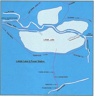 The Loktak Hydropower Project on the Manipur River or Imphal River, with the Loktak Lake forming the head waters to provide regulated storage for power generation, was built in 1983 as a multipurpose project with power generation of 105 MW (3x35 MW) for power supply to Manipur, Nagaland
, Assam
, Mizoram
, Arunachal Pradesh
, Meghalaya
and Tripura
, and lift irrigation
to an area of 23000 ha (56,834.2 acre) in the Manipur valley. The main components of the project, as built, are, a) the Ithai barrage, across the Manipur river of 10.7 m (35.1 ft) height and 58.8 m (192.9 ft) length with three spillway bays, b) water conductor system for trans-basin diversion comprising an open channel
of 2.323 km (1.4 mi) length, a cut and cover section of 1.077 km (0.669218437371842 mi) length (bed width 18 m (59.1 ft), followed by a Head Race Tunnel
of 3.81 m (12.5 ft) diameter (horseshoe type) and 6.62 km (4.1 mi) long to carry a discharge of 58.8 m3/s (42 m3/s) for power generation and 16.8 m3/s for irrigation), c) a surge shaft, d) penstock
s and e) a surface powerhouse
and a tailrace channel on the right bank of the narrow Leimatak River with three units of 35 MW capacity each generating an annual energy of 448 GW·h (1.613 PJ). The downstream Loktak Power Project in cascade to utilize the regulated releases from the upper project for further power generation of 90 MW is proposed to be taken up for joint implementation by NHPC and the Government of Manipur.
The project has invited severe criticism since the water level in the lake at the Ithai barrage is maintained throughout the year at FRL 786.5 m (2,580.4 ft) from considerations of power generation from the well planned water conductor system. The problem in the lake is, however, diverse; economic activities in and around the lake, and encroachments by 50,400 fishermen for extensive fishing activity are also cited to be some of the reasons. Other reasons for the distress situation in the lake are a) jhum (shifting) cultivation, b) extensive deforestation
and unscientific land use practices in the catchment areas which bring large amount of silt
into the lake and c) undefined ownership of the lake where the stakeholders are the districts of Imphal west district, Bishnupur
and Thoubal causing lack of integrated approach to the lakes potential for providing benefits.
recorded are as under.
Vegetation
The important vegetation of the phumdis recorded are Eichornia crassipes, Phragmites
karka, Oryza sativa
, Zizania latifolia, Cynodon
spp., Limnophila spp., Sagitlaria spp., Saccharum latifolium, Erianthus pucerus, Erianthus ravennae, Lersi hexandra, Carex
spp.; Phragmites
karka is reported to be the dominant species.
In the habitat patch with rooted floating plants, vegetation comprises the a) Nelumbo nucifera
, b) Trapa natans, c) Euryale ferox
, d) Nymphaea alba
, e) N. nouchali, N. stellata and f) Nymphoides indica.
 116 species of birds have been noted in the lake including 21 species of migratory waterfowl
(most migrating from different parts of the northern hemisphere
beyond the Himalayas
). Also recorded were 425 species of animals—249 vertebrates and 176 invertebrates). The list includes rare animals such as the Indian python
, sambhar and barking deer. Keibul Lamjao National Park
is the natural habitat of one of the most endangered deer, the Brow-antlered deer (Cervus eldi eldi) which was once thought to be extinct, which was declared a national park only to preserve and conserve this species of Eld's Deer
.
Avifauna
But the avifauna recorded in different habitats of the lake is reported to be declining. Briefly, the details of the avifauna recorded now are elaborated.
In the central part of the lake waterfowl, including dabbling ducks and diving ducks are reported but their numbers are declining due to proliferation of phumdis.
In the habitat part of the rooted plants, Hydrophasianus chirurgus, Metopidius indicus, and others were reported; once abundant now show a declining trend.
Small hillocks (though showing degraded condition) in the lake show big trees; birds of prey such as Milvus
migrans lineatus and Circus
aeruginosus have been recorded on these trees.
Species of hornbills found are the Brown-backed Hornbill, Rufous-necked Hornbill
, Wreathed Hornbill
, the Pied Hornbill and the Great Pied Hornbill.
Aqua fauna
Fish yield from the lake is reported to be about 1,500 tonnes (6,600,000 lb) every year. The State Fishery Department has introduced millions of fingerlings
of Indian and exotic major carps. Natural capture fishery without the requirement of any lease or licence was also in vogue in the lake. The lake fishery is now a mixture of capture and culture systems. Nine mini-hatcheries opened by the State Government has the capacity to produce one million fish fingerlings in a day. Fifty percent of the fingerlings produced were released into the Loktak Lake and the balance were distributed to beneficiary fishing committees. The new fish varieties introduced in lake were grass carp
, silver carp and the old varieties of the local fishes like Channa punctatus (ngamu), Anabus testudinius (ukabi), Anguilla
(ngaril), pangba, tharak, and ngashap stated to be under serious decline.
Fauna
 Fauna recorded in the precincts of the Lake in the Keibul Lamjo National Park are the Indian python
, sambhar, barking deer, the endangered Sangai species of Eld's Deer
, wild bear, Muntiacus muntjak, Rhesus monkey, Hoolock gibbon
, stump-tailed macaque
, Indian civet
Viverra zibetha, marbled cat
and Temminck's golden cat.
The degradation of the catchment area has occurred. Deforestation and shifting cultivation in the catchment areas have accelerated the process of soil erosion resulting in the lake’s shrinkage due to siltation. The annual silt
flow into the lake is estimated to be 336,325 tons.
The nutrients from catchment area and domestic sewage
from Imphal
city carried by Nambul River are discharged into the lake affecting its water quality, thus encouraging the growth of water hyacinth
and phumdis. All these activities have direct bearing on ecological stability
of the lake. Interference in navigation
and overall aesthetic value of the Lake are other reported adverse effects.
The construction of Ithai barrage and maintaining constant water level at full reservoir level (FRL) has led to a) changes in hydrological regime thereby affecting ecological processes and functions of the wetland, b) inundation of agricultural lands and displacement of people from flooded lands and c) loss of fish population and diversity.
The thickness of phumdis has decreased in the Keibul Lamjao National Park thereby threatening the survival of Sangai deer and interference in the migration of fishes from Chindwin–Irrawady River system of Myanmar resulting in changes in the species composition.
The population of a number of economic plants such as Saccharum species, Setaria pumila
, Alpinia nigra, Hedychium
spicatum and the major food plants like the Zizania, Latifolia, Carex species, Coix species, Narenga
has decreased resulting in starvation conditions for the endangered Sangai deer. With the phumdis becoming thinner, the hoofs of the limbs of Sangai get stuck in the marsh and results in their drowning. Production of the edible fruit and rhizome
(thamchet and thambou) of lotus
plants has decreased to a great extent. Plants have also degraded due to polluted water.
Livelihood of people dependent on the sale of edible fruit and rhizome of lotus plant products and Euryale ferox (thanging) has suffered due to steep decline in the growth of these plant species.
Today, Loktak Lake is at the highest level of eutrophication and the only brow-antlered deer is at the verge of extinction.
Canada
Environment Facility (ICEF). A Project Report titled "Sustainable Development & Water Resources Management of Loktak Lake (SDWRML)" has been prepared. The report gives a review of its activities on the project done for over six years (from February 1, 1998 till the end of March 2004) with the following pertinent observations.
In an interdependent multiple socioeconomic cum historical cum technological/scientific milieu, the problem of the Loktak lake is multi-dimensional and complex.
The project had not made the desired impact on livelihood activities of the target communities.
The scientific data system and analysis was critical for planning appropriate interventions.
In the past, complex environmental problems were not adequately addressed.
LDA, basically an engineering organization, addressed several developmental activities with due involvement of local communities and its capacity to address the situation is well organized.
Even though the Ithai barrage and its operation by NHPC have contributed to the deterioration of the lake
environment
and the people around it, the mind set of the people (conditioned by the water level and submergence) that operation of the project needs drastic change to solve the lakes' problems had prevented examination of feasible alternate solutions, given the situation that drastic change of NHPC approach to operate the project was not feasible.
The project design was sound but focus on ultimate goal was not adequate. Participation of NGOs in the project was not sufficient. The design of a fish hatchery
(a Chinese
design) was too large and had to be scaled down. Documentation, communication activities of the project and MIS system were good.
Based on all the analysis, the future approach suggested involves mitigation measures as elaborated are: i) The Nambol River carries sewage of nutrients of Imphal town into the lake which results in prolific growth of phumdis and deteriorates water quality
. This is an urban problem and there is urgent need to treat and control this aspect, even if it is expensive;
ii) Reduce soil erosion and sedimentation of the lake by enlarging the scope of micro-watersheds
in the catchment area treatment plan;
iii) Construct a channel
through the Keibul Lamjao National Park to enable phumdis to settle at the bed of the lake;
iv) Resolve the encroachment problem, by demarcating the lake boundary, which would result in a targeted and concerted action plan;
v) Implement action plans that are economically viable and technically feasible resulting in livelihood enhancement such as evolving an attractive resettlement plan for the phumdi dwellers backed by remunerative livelihood program; and
vi) Examine introduction of fishing net instead of Athapum (Athapam means phumdis in circular shape floating in the lake, planted or cultured artificially for catching fish) practiced presently to be dismantled.
 Well connected by road and air, Imphal, the capita city of Manipur is 39 km (24.2 mi) away from the lake, by road. The lake is a unique destination for tourism. The lake offers excellent opportunities for visitors to enjoy the beauty of the lake and its several islands located inside the it that are studded with floating phumdis of different geometrical shapes. The important islands which offer facilities for visitors are the Sandra and Phubala.
The Sendra Tourist Home on the island with an attached Cafeteria
in the middle of the lake is an ideal tourist spot. Visitors get a bird's eye view of life on the lake—small islands that are actually floating weed on which the lake people live.
Phubala resort, on the Phubala Island, is 40 km (24.9 mi) from Imphal.
India
India , officially the Republic of India , is a country in South Asia. It is the seventh-largest country by geographical area, the second-most populous country with over 1.2 billion people, and the most populous democracy in the world...
, also called the only Floating lake in the world due to the floating phumdi
Phumdi
Phumdis are a series of floating islands, exclusive to the Loktak Lake in Manipur state, in northeastern India. They cover a substantial part of the lake area and are heterogeneous masses of vegetation, soil and organic matter, in different stages of decay. The largest single mass of phumdi is in...
s (heterogeneous mass of vegetation, soil, and organic matters at various stages of decomposition) on it, is located near Moirang
Moirang
Moirang is a city and a municipal council in Bishnupur district in the Indian state of Manipur.Moirang is a town situated in the north east of India, 45 km from Imphal, Manipur. The Moirang C.D. Block came into existence on 4 April 1985 with its headquarters at Moirang Khunou about 1.5 km...
in Manipur
Manipur
Manipur is a state in northeastern India, with the city of Imphal as its capital. Manipur is bounded by the Indian states of Nagaland to the north, Mizoram to the south and Assam to the west; it also borders Burma to the east. It covers an area of...
state, India. The etymology
Etymology
Etymology is the study of the history of words, their origins, and how their form and meaning have changed over time.For languages with a long written history, etymologists make use of texts in these languages and texts about the languages to gather knowledge about how words were used during...
of Loktak is Lok = "stream" and tak = "the end". The Keibul Lamjao National Park
Keibul Lamjao National Park
The Keibul Lamjao National Park is a national park in the Bishnupur district of the state of Manipur in India. It is in area, the only floating park in the world, located in North East India, and an integral part of Loktak Lake....
, which is the last natural refuge of the endangered sangai
Sangai
The Sangai is an endemic, rare and endangered Brow-antlered deer found only in Manipur, India. Its common English name is Manipur Brow-antlered Deer and the scientific name, Rucervus eldi eldi McClelland. It lives in the marshy wetland in Keibul Lamjao about 45 km from Imphal...
or Manipur brow-antlered deer (Rucervus eldi eldi), one of three subspecies of Eld's Deer
Eld's Deer
Eld's Deer , also known as the Thamin or Brow-antlered Deer, is an endangered species of deer indigenous to southeastern Asia. The species was first discovered by westerners in Manipur in India in 1839. The original scientific name Cervus eldi was coined in 1844 in honour of Lt. Percy Eld – a...
, covering an area of 40 km² (15.4 sq mi), is situated in the southeastern shores of this lake and is the largest of all the phumdis in the lake.
This ancient lake plays an important role in the economy of Manipur
Manipur
Manipur is a state in northeastern India, with the city of Imphal as its capital. Manipur is bounded by the Indian states of Nagaland to the north, Mizoram to the south and Assam to the west; it also borders Burma to the east. It covers an area of...
. It serves as a source of water for hydropower
Hydropower
Hydropower, hydraulic power, hydrokinetic power or water power is power that is derived from the force or energy of falling water, which may be harnessed for useful purposes. Since ancient times, hydropower has been used for irrigation and the operation of various mechanical devices, such as...
generation, irrigation and drinking water supply. The lake is also a source of livelihood for the rural fisherman who live in the surrounding areas and on phumdis, also known as “phumshongs”. Human activity has led to severe pressure on the lake ecosystem. 55 rural and urban hamlets around the lake have a population of about 100,000 people.
Considering the ecological status and its biodiversity values, the lake was initially designated as a wetland of international importance
Ramsar list of wetlands of international importance
This is the list of wetlands of international importance as defined by the Ramsar Convention for the conservation and sustainable utilization of wetlands, recognizing the fundamental ecological functions of wetlands and their economic, cultural, scientific, and recreational value.The Convention...
under the Ramsar Convention
Ramsar Convention
The Ramsar Convention is an international treaty for the conservation and sustainable utilization of wetlands, i.e., to stem the progressive encroachment on and loss of wetlands now and in the future, recognizing the fundamental ecological functions of wetlands and their economic, cultural,...
on March 23, 1990. But the lake was designated by the Ramsar Convention under the Montreux Record on June 16, 1993 for the reason that:
.
a record of Ramsar sites where changes in ecological character have occurred, are occurring or are likely to occur.
Topography and geography
Of the two river systems which drain the Manipur state—the Barak riverBarak River
The Barak River is one of the major rivers of southern Assam and is a part of the Surma-Meghna River System. It is the biggest and the most important of all the rivers in the Manipur hill territory, from where it originates....
and the Manipur River
Manipur River
-See also:*List of rivers of Burma...
—the Manipur River flows through the Manipur Valley. The river rises in the north at Karong, flows south of Imphal
Imphal
Imphal is the capital of the Indian state of Manipur.In the heart of the town and surrounded by a moat, are ruins of the old Palace of Kangla. Kangla Fort used to be the home of the Assam Rifles, a paramilitary force and on November 2004 it was handed over to state of Manipur by Prime minister Dr....
and hence is also known as the Imphal River
Imphal River
The Imphal River is a major river of Manipur state, northeastern India. It is a tributary of the Manipur River, joining it in Thoubal district.It flows past Loktak Lake and the city of Imphal and joins the Lilong River, some 10 kilometres to the south....
. Along its course through the valley, downstream of Imphal, the bed slope of the river is gentle. Drainage pattern, typical of hilly terrain, is sub-dendritic, sub-parallel and sub-radial, which is dictated by the structure and lithology
Lithology
The lithology of a rock unit is a description of its physical characteristics visible at outcrop, in hand or core samples or with low magnification microscopy, such as colour, texture, grain size, or composition. It may be either a detailed description of these characteristics or be a summary of...
of the area. Imphal, Iril and Thoubal River valleys also exhibit a meandering river course.
At the Ithai barrage outlet of the Lake, the direct catchment
Drainage basin
A drainage basin is an extent or an area of land where surface water from rain and melting snow or ice converges to a single point, usually the exit of the basin, where the waters join another waterbody, such as a river, lake, reservoir, estuary, wetland, sea, or ocean...
area draining into the lake is 980 km² (378.4 sq mi) out of which 430 km² (166 sq mi) is under paddy
Paddy field
A paddy field is a flooded parcel of arable land used for growing rice and other semiaquatic crops. Paddy fields are a typical feature of rice farming in east, south and southeast Asia. Paddies can be built into steep hillsides as terraces and adjacent to depressed or steeply sloped features such...
cultivation, 150 km² (57.9 sq mi) under habitation and 400 km² (154.4 sq mi) under forest cover. The area of the lake is 236.21 km² (91.2 sq mi), comprising large pockets of open water and marsh
Marsh
In geography, a marsh, or morass, is a type of wetland that is subject to frequent or continuous flood. Typically the water is shallow and features grasses, rushes, reeds, typhas, sedges, other herbaceous plants, and moss....
y land formed at the southern part of the Imphal valley up to the confluence of Manipur River and Khuga River in the district of Imphal West. The Lake is divided into two zones, namely, the “Core Zone” which is the no-development zone or totally protected zone comprising 70.3 km² (27.1 sq mi) and the balance area is called the "Buffer Zone".
Within the lake and on its periphery, there are 14 hills of varying size and elevation; in the southern part of the lake are the Sendra, Ithing and Thanga islands.
Lake Zonation
Geographically, in terms of biodiversity and pressure of human activities, the lake is broadly divided into northern, central and southern zones as elaborated below.
The Northern Zone, extending from eastern side of Nambol River near Ngaikhong Khunou to Phabakchao including Maibam Phumlak, has five main streams/rivers namely, the Nambol, Merakhong, Ishok, Waishel and Nambul flowing into the lake. The zone is separated from the central zone by large phumdis (varying thickness of 0.4 to 4.5 m or 1.3 to 14.8 ft) that stretches from the northwest to the southeast. During January to March, phumdis in this area are usually burnt for construction of fish
Fish farming
Fish farming is the principal form of aquaculture, while other methods may fall under mariculture. Fish farming involves raising fish commercially in tanks or enclosures, usually for food. A facility that releases young fish into the wild for recreational fishing or to supplement a species'...
cum paddy
Paddy field
A paddy field is a flooded parcel of arable land used for growing rice and other semiaquatic crops. Paddy fields are a typical feature of rice farming in east, south and southeast Asia. Paddies can be built into steep hillsides as terraces and adjacent to depressed or steeply sloped features such...
farms; many large fish farms with raised levee
Levee
A levee, levée, dike , embankment, floodbank or stopbank is an elongated naturally occurring ridge or artificially constructed fill or wall, which regulates water levels...
s have been built.
The Southern Zone encompasses the Keibul Lamjao National Park
Keibul Lamjao National Park
The Keibul Lamjao National Park is a national park in the Bishnupur district of the state of Manipur in India. It is in area, the only floating park in the world, located in North East India, and an integral part of Loktak Lake....
, Ungamel and Kumbi pats at the southern part of the lake and the zone is linked with Khuga River by the Ungamel channel. The Imphal River is also linked with this zone by the Khordak channel. The western catchment drained by the Kangshoibi River flows into this zone. Proliferation of phumdis has been observed near the mouth of Ungamel channel, Kumbi pat, Nongmaikhong and Khordak area.
Geology
CretaceousCretaceous
The Cretaceous , derived from the Latin "creta" , usually abbreviated K for its German translation Kreide , is a geologic period and system from circa to million years ago. In the geologic timescale, the Cretaceous follows the Jurassic period and is followed by the Paleogene period of the...
limestone
Limestone
Limestone is a sedimentary rock composed largely of the minerals calcite and aragonite, which are different crystal forms of calcium carbonate . Many limestones are composed from skeletal fragments of marine organisms such as coral or foraminifera....
, the Disang with Serpentinites (Lower to Middle Eocene
Eocene
The Eocene Epoch, lasting from about 56 to 34 million years ago , is a major division of the geologic timescale and the second epoch of the Paleogene Period in the Cenozoic Era. The Eocene spans the time from the end of the Palaeocene Epoch to the beginning of the Oligocene Epoch. The start of the...
–Upper Cretaceous
Cretaceous
The Cretaceous , derived from the Latin "creta" , usually abbreviated K for its German translation Kreide , is a geologic period and system from circa to million years ago. In the geologic timescale, the Cretaceous follows the Jurassic period and is followed by the Paleogene period of the...
), the Surmas and the Tipams (Miocene
Miocene
The Miocene is a geological epoch of the Neogene Period and extends from about . The Miocene was named by Sir Charles Lyell. Its name comes from the Greek words and and means "less recent" because it has 18% fewer modern sea invertebrates than the Pliocene. The Miocene follows the Oligocene...
) are the dominant rock formations in the catchment of the Manipur basin. Higher reaches of hills have the Disang and Tipam groups of rocks while Surma group occurs in the lower reaches. Grey sandstone
Sandstone
Sandstone is a sedimentary rock composed mainly of sand-sized minerals or rock grains.Most sandstone is composed of quartz and/or feldspar because these are the most common minerals in the Earth's crust. Like sand, sandstone may be any colour, but the most common colours are tan, brown, yellow,...
–grit–conglomerate
Conglomerate (geology)
A conglomerate is a rock consisting of individual clasts within a finer-grained matrix that have become cemented together. Conglomerates are sedimentary rocks consisting of rounded fragments and are thus differentiated from breccias, which consist of angular clasts...
–limestone
Limestone
Limestone is a sedimentary rock composed largely of the minerals calcite and aragonite, which are different crystal forms of calcium carbonate . Many limestones are composed from skeletal fragments of marine organisms such as coral or foraminifera....
sequences intruded by serpentinites containing minor amounts of enstalite, chromite
Chromite
Chromite is an iron chromium oxide: FeCr2O4. It is an oxide mineral belonging to the spinel group. Magnesium can substitute for iron in variable amounts as it forms a solid solution with magnesiochromite ; substitution of aluminium occurs leading to hercynite .-Occurrence:Chromite is found in...
, amphiboles and magnetite
Magnetite
Magnetite is a ferrimagnetic mineral with chemical formula Fe3O4, one of several iron oxides and a member of the spinel group. The chemical IUPAC name is iron oxide and the common chemical name is ferrous-ferric oxide. The formula for magnetite may also be written as FeO·Fe2O3, which is one part...
constitute the Disang formation. Argillaceous and arneceous sequence represents the Surma and Tipam groups, respectively.
Climate
With an average annual rainfall of 1183 mm (46.57 in) tropical monsoon climate prevails in the valley. Temperatures range from 0 to 35 °C (32 to 95 °F). February and March are the driest months.Hydrology
Loktak Lake is fed by the Manipur river and several tributaries and ‘Ungamel Channel’ (Ithai Barrage) is its only outlet now. The origin of the Manipur river system and its tributaries, which flows in a north-south direction and drains into the lake is from the hill ranges immediately to the west of the lake. The five major rivers with indirect catchment area of 7157 km² (2,763.3 sq mi) are the Imphal (also called the Manipur River), the Iril, the Thoubal, the Sekmai and the Khuga. The other major streams which drain into the lake and which bring in lot of silt are the Nambul, the Nambol, the Thongjarok, the Awang Khujairok, the Awang Kharok, the Ningthoukhong, the Potsangbam, the Oinam, the Keinou and the Irulok. The Lake, located on the southern side of the Manipur river basin, is at the lowest elevation in the valley and no other major river flows into the lake, except a few rivulets.Though hydrological data on river basin has not been adequately monitored, the Department of Earth Science
Earth science
Earth science is an all-embracing term for the sciences related to the planet Earth. It is arguably a special case in planetary science, the Earth being the only known life-bearing planet. There are both reductionist and holistic approaches to Earth sciences...
, Manipur University
Manipur University
Manipur University was established on June 5, 1980, under the Manipur University Act.1980 , as a teaching cum-affiliating University at Imphal with territorial jurisdiction over the whole of the state of Manipur. It was converted into a Central University w.e.f. 13 October 2005...
has in its report of 1996 assessed the average runoff
Surface runoff
Surface runoff is the water flow that occurs when soil is infiltrated to full capacity and excess water from rain, meltwater, or other sources flows over the land. This is a major component of the water cycle. Runoff that occurs on surfaces before reaching a channel is also called a nonpoint source...
of Manipur River as 519,200 ha·m (4,209,000 acre·ft; 5.192 km3) from a total catchment area of 697 km² (269.1 sq mi) at the Ithai barrage. The ground water potential has been assessed estimated around 44 cubic hectometre per annum.
Water resources development
Several water resources development projects have been built in the Manipur River basin to meet growing demands for irrigation. Seven river valley projects have been completed; these are the Singda Dam Project, Thoubal Dam Project and Khuga Dam Project which are of multipurpose type, the Imphal Barrage Project and the Sekmai Barrage Project—both medium irrigation projects. The most discussed project is the Loktak Multipurpose Project, which provides hydropowerHydropower
Hydropower, hydraulic power, hydrokinetic power or water power is power that is derived from the force or energy of falling water, which may be harnessed for useful purposes. Since ancient times, hydropower has been used for irrigation and the operation of various mechanical devices, such as...
, irrigation and water supply benefits but has attracted adverse criticism for the drastic alteration caused by the project to the hydrological regime
Regime
The word regime refers to a set of conditions, most often of a political nature.-Politics:...
of the Loktak Lake and associated wetlands.
Loktak Multipurpose Project
Nagaland
Nagaland is a state in the far north-eastern part of India. It borders the state of Assam to the west, Arunachal Pradesh and part of Assam to the north, Burma to the east and Manipur to the south. The state capital is Kohima, and the largest city is Dimapur...
, Assam
Assam
Assam , also, rarely, Assam Valley and formerly the Assam Province , is a northeastern state of India and is one of the most culturally and geographically distinct regions of the country...
, Mizoram
Mizoram
Mizoram is one of the Seven Sister States in North Eastern India, sharing borders with the states of Tripura, Assam, Manipur and with the neighbouring countries of Bangladesh and Burma. Mizoram became the 23rd state of India on 20 February 1987. Its capital is Aizawl. Mizoram is located in the...
, Arunachal Pradesh
Arunachal Pradesh
Arunachal Pradesh is a state of India, located in the far northeast. It borders the states of Assam and Nagaland to the south, and shares international borders with Burma in the east, Bhutan in the west, and the People's Republic of China in the north. The majority of the territory is claimed by...
, Meghalaya
Meghalaya
Meghalaya is a state in north-eastern India. The word "Meghalaya" literally means the Abode of Clouds in Sanskrit and other Indic languages. Meghalaya is a hilly strip in the eastern part of the country about 300 km long and 100 km wide, with a total area of about 8,700 sq mi . The...
and Tripura
Tripura
Tripura is a state in North-East India, with an area of . It is the third smallest state of India, according to area. Tripura is surrounded by Bangladesh on the north, south, and west. The Indian states of Assam and Mizoram lie to the east. The capital is Agartala and the main languages spoken are...
, and lift irrigation
Irrigation
Irrigation may be defined as the science of artificial application of water to the land or soil. It is used to assist in the growing of agricultural crops, maintenance of landscapes, and revegetation of disturbed soils in dry areas and during periods of inadequate rainfall...
to an area of 23000 ha (56,834.2 acre) in the Manipur valley. The main components of the project, as built, are, a) the Ithai barrage, across the Manipur river of 10.7 m (35.1 ft) height and 58.8 m (192.9 ft) length with three spillway bays, b) water conductor system for trans-basin diversion comprising an open channel
Channel (geography)
In physical geography, a channel is the physical confine of a river, slough or ocean strait consisting of a bed and banks.A channel is also the natural or human-made deeper course through a reef, sand bar, bay, or any shallow body of water...
of 2.323 km (1.4 mi) length, a cut and cover section of 1.077 km (0.669218437371842 mi) length (bed width 18 m (59.1 ft), followed by a Head Race Tunnel
Tunnel
A tunnel is an underground passageway, completely enclosed except for openings for egress, commonly at each end.A tunnel may be for foot or vehicular road traffic, for rail traffic, or for a canal. Some tunnels are aqueducts to supply water for consumption or for hydroelectric stations or are sewers...
of 3.81 m (12.5 ft) diameter (horseshoe type) and 6.62 km (4.1 mi) long to carry a discharge of 58.8 m3/s (42 m3/s) for power generation and 16.8 m3/s for irrigation), c) a surge shaft, d) penstock
Penstock
A penstock is a sluice or gate or intake structure that controls water flow, or an enclosed pipe that delivers water to hydraulic turbines and sewerage systems. It is a term that has been inherited from the technology of wooden watermills....
s and e) a surface powerhouse
Power station
A power station is an industrial facility for the generation of electric energy....
and a tailrace channel on the right bank of the narrow Leimatak River with three units of 35 MW capacity each generating an annual energy of 448 GW·h (1.613 PJ). The downstream Loktak Power Project in cascade to utilize the regulated releases from the upper project for further power generation of 90 MW is proposed to be taken up for joint implementation by NHPC and the Government of Manipur.
The project has invited severe criticism since the water level in the lake at the Ithai barrage is maintained throughout the year at FRL 786.5 m (2,580.4 ft) from considerations of power generation from the well planned water conductor system. The problem in the lake is, however, diverse; economic activities in and around the lake, and encroachments by 50,400 fishermen for extensive fishing activity are also cited to be some of the reasons. Other reasons for the distress situation in the lake are a) jhum (shifting) cultivation, b) extensive deforestation
Deforestation
Deforestation is the removal of a forest or stand of trees where the land is thereafter converted to a nonforest use. Examples of deforestation include conversion of forestland to farms, ranches, or urban use....
and unscientific land use practices in the catchment areas which bring large amount of silt
Silt
Silt is granular material of a size somewhere between sand and clay whose mineral origin is quartz and feldspar. Silt may occur as a soil or as suspended sediment in a surface water body...
into the lake and c) undefined ownership of the lake where the stakeholders are the districts of Imphal west district, Bishnupur
Bishnupur
-Kingdoms:*Bishnupur kingdom in what is today Bankura District, Bengal, India.-CD Blocks:* Bishnupur, Bankura - in Bankura district, West Bengal* Bishnupur I - in South 24 Parganas district, West Bengal...
and Thoubal causing lack of integrated approach to the lakes potential for providing benefits.
Biodiversity
A rich biodiversity with habitat heterogeneity has been recorded during a scientific survey carried out between January 2000 and December 2002 in different habitat patches of the lake. The lake’s rich biological diversity comprises 233 species of aquatic macrophytes of emergent, submergent, free-floating and rooted floating leaf types. But in the declining trend of vegetation, the important floraFlora
Flora is the plant life occurring in a particular region or time, generally the naturally occurring or indigenous—native plant life. The corresponding term for animals is fauna.-Etymology:...
recorded are as under.
Vegetation
The important vegetation of the phumdis recorded are Eichornia crassipes, Phragmites
Phragmites
Phragmites, the Common reed, is a large perennial grass found in wetlands throughout temperate and tropical regions of the world. Phragmites australis is sometimes regarded as the sole species of the genus Phragmites, though some botanists divide Phragmites australis into three or four species...
karka, Oryza sativa
Oryza sativa
Oryza sativa, commonly known as Asian rice, is the plant species most commonly referred to in English as rice. Oryza sativa is the cereal with the smallest genome, consisting of just 430Mb across 12 chromosomes...
, Zizania latifolia, Cynodon
Cynodon
Cynodon is a genus of nine species of grasses, native to warm temperate to tropical regions of the Old World. The genus as a whole as well as its species are commonly known as Bermuda Grass or Dog's Tooth Grass.-Species:...
spp., Limnophila spp., Sagitlaria spp., Saccharum latifolium, Erianthus pucerus, Erianthus ravennae, Lersi hexandra, Carex
Carex
Carex is a genus of plants in the family Cyperaceae, commonly known as sedges. Other members of the Cyperaceae family are also called sedges, however those of genus Carex may be called "true" sedges, and it is the most species-rich genus in the family. The study of Carex is known as...
spp.; Phragmites
Phragmites
Phragmites, the Common reed, is a large perennial grass found in wetlands throughout temperate and tropical regions of the world. Phragmites australis is sometimes regarded as the sole species of the genus Phragmites, though some botanists divide Phragmites australis into three or four species...
karka is reported to be the dominant species.
In the habitat patch with rooted floating plants, vegetation comprises the a) Nelumbo nucifera
Nelumbo nucifera
Nelumbo nucifera, known by a number of names including Indian Lotus, Sacred Lotus, Bean of India, or simply Lotus, is a plant in the monogeneric family Nelumbonaceae...
, b) Trapa natans, c) Euryale ferox
Euryale ferox
Euryale ferox is the only species in the genus Euryale. It is a flowering plant classified in the water lily family, Nymphaeaceae, although it is occasionally regarded as a distinct family Euryalaceae...
, d) Nymphaea alba
Nymphaea alba
Nymphaea alba, also known as the European White Waterlily, White Lotus, or Nenuphar, is an aquatic flowering plant of the family Nymphaeaceae....
, e) N. nouchali, N. stellata and f) Nymphoides indica.
Fauna
Waterfowl
Waterfowl are certain wildfowl of the order Anseriformes, especially members of the family Anatidae, which includes ducks, geese, and swans....
(most migrating from different parts of the northern hemisphere
Northern Hemisphere
The Northern Hemisphere is the half of a planet that is north of its equator—the word hemisphere literally means “half sphere”. It is also that half of the celestial sphere north of the celestial equator...
beyond the Himalayas
Himalayas
The Himalaya Range or Himalaya Mountains Sanskrit: Devanagari: हिमालय, literally "abode of snow"), usually called the Himalayas or Himalaya for short, is a mountain range in Asia, separating the Indian subcontinent from the Tibetan Plateau...
). Also recorded were 425 species of animals—249 vertebrates and 176 invertebrates). The list includes rare animals such as the Indian python
Indian Python
Python molurus is a large nonvenomous python species found in many tropic and subtropic areas of Southern and Southeast Asia. It is known by the common names Indian python, black-tailed python, and Indian rock python. Two subspecies are currently recognized: the nominate subspecies and the Burmese...
, sambhar and barking deer. Keibul Lamjao National Park
Keibul Lamjao National Park
The Keibul Lamjao National Park is a national park in the Bishnupur district of the state of Manipur in India. It is in area, the only floating park in the world, located in North East India, and an integral part of Loktak Lake....
is the natural habitat of one of the most endangered deer, the Brow-antlered deer (Cervus eldi eldi) which was once thought to be extinct, which was declared a national park only to preserve and conserve this species of Eld's Deer
Eld's Deer
Eld's Deer , also known as the Thamin or Brow-antlered Deer, is an endangered species of deer indigenous to southeastern Asia. The species was first discovered by westerners in Manipur in India in 1839. The original scientific name Cervus eldi was coined in 1844 in honour of Lt. Percy Eld – a...
.
Avifauna
But the avifauna recorded in different habitats of the lake is reported to be declining. Briefly, the details of the avifauna recorded now are elaborated.
In the central part of the lake waterfowl, including dabbling ducks and diving ducks are reported but their numbers are declining due to proliferation of phumdis.
In the habitat part of the rooted plants, Hydrophasianus chirurgus, Metopidius indicus, and others were reported; once abundant now show a declining trend.
Small hillocks (though showing degraded condition) in the lake show big trees; birds of prey such as Milvus
Milvus
Milvus is a genus of medium-sized birds of prey. It is an Old World group consisting of three kites which form part of the subfamily Milvinae...
migrans lineatus and Circus
Circus
A circus is commonly a travelling company of performers that may include clowns, acrobats, trained animals, trapeze acts, musicians, hoopers, tightrope walkers, jugglers, unicyclists and other stunt-oriented artists...
aeruginosus have been recorded on these trees.
Species of hornbills found are the Brown-backed Hornbill, Rufous-necked Hornbill
Rufous-necked Hornbill
The Rufous-necked Hornbill is a species of hornbill found in broadleaved forests at altitudes of in Bhutan, north-eastern India, Burma, southern Yunnan, south-eastern Tibet, northern and western Thailand, northern Laos and northern Vietnam. Numbers have declined significantly due to habitat loss...
, Wreathed Hornbill
Wreathed Hornbill
The Wreathed Hornbill , also known as the Bar-pouched Wreathed Hornbill, is a species of hornbill found in forests from far north-eastern India and Bhutan, east and south through mainland south-east Asia and the Greater Sundas, except Sulawesi. It is 75–100 cm long...
, the Pied Hornbill and the Great Pied Hornbill.
Aqua fauna
Fish yield from the lake is reported to be about 1,500 tonnes (6,600,000 lb) every year. The State Fishery Department has introduced millions of fingerlings
Fingerlings
-External links:*...
of Indian and exotic major carps. Natural capture fishery without the requirement of any lease or licence was also in vogue in the lake. The lake fishery is now a mixture of capture and culture systems. Nine mini-hatcheries opened by the State Government has the capacity to produce one million fish fingerlings in a day. Fifty percent of the fingerlings produced were released into the Loktak Lake and the balance were distributed to beneficiary fishing committees. The new fish varieties introduced in lake were grass carp
Grass carp
The grass carp is a herbivorous, freshwater fish species of family Cyprinidae, and the only species of the genus Ctenopharyngodon. It is cultivated in China for food, but was introduced in Europe and the United States for aquatic weed control...
, silver carp and the old varieties of the local fishes like Channa punctatus (ngamu), Anabus testudinius (ukabi), Anguilla
Anguilla
Anguilla is a British overseas territory and overseas territory of the European Union in the Caribbean. It is one of the most northerly of the Leeward Islands in the Lesser Antilles, lying east of Puerto Rico and the Virgin Islands and directly north of Saint Martin...
(ngaril), pangba, tharak, and ngashap stated to be under serious decline.
Fauna
Indian Python
Python molurus is a large nonvenomous python species found in many tropic and subtropic areas of Southern and Southeast Asia. It is known by the common names Indian python, black-tailed python, and Indian rock python. Two subspecies are currently recognized: the nominate subspecies and the Burmese...
, sambhar, barking deer, the endangered Sangai species of Eld's Deer
Eld's Deer
Eld's Deer , also known as the Thamin or Brow-antlered Deer, is an endangered species of deer indigenous to southeastern Asia. The species was first discovered by westerners in Manipur in India in 1839. The original scientific name Cervus eldi was coined in 1844 in honour of Lt. Percy Eld – a...
, wild bear, Muntiacus muntjak, Rhesus monkey, Hoolock gibbon
Hoolock gibbon
The hoolock gibbons , also known as hoolocks, are two primate species from the family of the gibbons .Hoolocks are the second largest of the gibbons, after the Siamang. They reach a size of 60 to 90 cm and weigh 6 to 9 kg...
, stump-tailed macaque
Macaque
The macaques constitute a genus of Old World monkeys of the subfamily Cercopithecinae. - Description :Aside from humans , the macaques are the most widespread primate genus, ranging from Japan to Afghanistan and, in the case of the barbary macaque, to North Africa...
, Indian civet
Civet
The family Viverridae is made up of around 30 species of medium-sized mammal, including all of the genets, the binturong, most of the civets, and the two African linsangs....
Viverra zibetha, marbled cat
Marbled Cat
The Marbled Cat is a small wild cat of South and Southeast Asia. Since 2002 it has been listed as vulnerable by IUCN as it occurs at low densities, and its total effective population size is suspected to be fewer than 10,000 mature individuals, with no single population numbering more than...
and Temminck's golden cat.
Threats
The Loktak lake and its precincts have faced serious problems due to loss of vegetal cover in the catchment area and construction of Ithai barrage at the outlet of the lake for multipurpose development of water resources. The issues are further elaborated below.The degradation of the catchment area has occurred. Deforestation and shifting cultivation in the catchment areas have accelerated the process of soil erosion resulting in the lake’s shrinkage due to siltation. The annual silt
Silt
Silt is granular material of a size somewhere between sand and clay whose mineral origin is quartz and feldspar. Silt may occur as a soil or as suspended sediment in a surface water body...
flow into the lake is estimated to be 336,325 tons.
The nutrients from catchment area and domestic sewage
Sewage
Sewage is water-carried waste, in solution or suspension, that is intended to be removed from a community. Also known as wastewater, it is more than 99% water and is characterized by volume or rate of flow, physical condition, chemical constituents and the bacteriological organisms that it contains...
from Imphal
Imphal
Imphal is the capital of the Indian state of Manipur.In the heart of the town and surrounded by a moat, are ruins of the old Palace of Kangla. Kangla Fort used to be the home of the Assam Rifles, a paramilitary force and on November 2004 it was handed over to state of Manipur by Prime minister Dr....
city carried by Nambul River are discharged into the lake affecting its water quality, thus encouraging the growth of water hyacinth
Water hyacinth
The seven species of water hyacinth comprise the genus Eichhornia. Water hyacinth are a free-floating perennial aquatic plant native to tropical and sub-tropical South America. With broad, thick, glossy, ovate leaves, water hyacinth may rise above the surface of the water as much as 1 meter in...
and phumdis. All these activities have direct bearing on ecological stability
Ecological stability
Ecological stability can refer to types of stability in a continuum ranging from resilience to constancy to persistence. The precise definition depends on the ecosystem in question, the variable or variables of interest, and the overall context...
of the lake. Interference in navigation
Navigation
Navigation is the process of monitoring and controlling the movement of a craft or vehicle from one place to another. It is also the term of art used for the specialized knowledge used by navigators to perform navigation tasks...
and overall aesthetic value of the Lake are other reported adverse effects.
The construction of Ithai barrage and maintaining constant water level at full reservoir level (FRL) has led to a) changes in hydrological regime thereby affecting ecological processes and functions of the wetland, b) inundation of agricultural lands and displacement of people from flooded lands and c) loss of fish population and diversity.
The thickness of phumdis has decreased in the Keibul Lamjao National Park thereby threatening the survival of Sangai deer and interference in the migration of fishes from Chindwin–Irrawady River system of Myanmar resulting in changes in the species composition.
The population of a number of economic plants such as Saccharum species, Setaria pumila
Setaria pumila
Setaria pumila is a species of grass known by many common names, including yellow foxtail, yellow bristlegrass, pigeon grass, and cattail grass. It is native to Europe, but it is known throughout the world as a common weed. It grows in lawns, sidewalks, roadsides, cultivated fields, and many other...
, Alpinia nigra, Hedychium
Hedychium
Hedychium is a genus of perennial plants native to tropical Asia and the Himalayas, commonly growing to between 120 and 180 cm tall. Common names include garland flower, ginger lily, and kahili ginger...
spicatum and the major food plants like the Zizania, Latifolia, Carex species, Coix species, Narenga
Narenga
Narenga is a village in Ancuabe District in Cabo Delgado Province in northeastern Mozambique.-External links:*...
has decreased resulting in starvation conditions for the endangered Sangai deer. With the phumdis becoming thinner, the hoofs of the limbs of Sangai get stuck in the marsh and results in their drowning. Production of the edible fruit and rhizome
Rhizome
In botany and dendrology, a rhizome is a characteristically horizontal stem of a plant that is usually found underground, often sending out roots and shoots from its nodes...
(thamchet and thambou) of lotus
Lotus (plant)
Lotus identifies various plant taxa:* Nelumbo, a genus of aquatic plants with showy flowers** Nelumbo nucifera, the Sacred or Indian lotus** Nelumbo lutea, the American or Yellow lotus...
plants has decreased to a great extent. Plants have also degraded due to polluted water.
Livelihood of people dependent on the sale of edible fruit and rhizome of lotus plant products and Euryale ferox (thanging) has suffered due to steep decline in the growth of these plant species.
Today, Loktak Lake is at the highest level of eutrophication and the only brow-antlered deer is at the verge of extinction.
Loktak Development Authority
To address all the issues raised on the health of the lake, as detailed above, Government of Manipur has set up the Loktak Development Authority (LDA) under “The Manipur Loktak Lake (Protection) Act, 2006 (Manipur Act 3 of 2006)” with the objective "to provide for administration, control, protection, improvement, conservation and development of the natural environment of the Loktak Lake and for matters connected with as incidental thereto."Restoration actions
In order to address the various issues plaguing the functioning of the lake and the project dependent on it, a detailed project study was instituted by the Loktak Development Authority (LDA) & Wetlands International Asia (WISA) with funding provided by the IndiaIndia
India , officially the Republic of India , is a country in South Asia. It is the seventh-largest country by geographical area, the second-most populous country with over 1.2 billion people, and the most populous democracy in the world...
Canada
Canada
Canada is a North American country consisting of ten provinces and three territories. Located in the northern part of the continent, it extends from the Atlantic Ocean in the east to the Pacific Ocean in the west, and northward into the Arctic Ocean...
Environment Facility (ICEF). A Project Report titled "Sustainable Development & Water Resources Management of Loktak Lake (SDWRML)" has been prepared. The report gives a review of its activities on the project done for over six years (from February 1, 1998 till the end of March 2004) with the following pertinent observations.
In an interdependent multiple socioeconomic cum historical cum technological/scientific milieu, the problem of the Loktak lake is multi-dimensional and complex.
The project had not made the desired impact on livelihood activities of the target communities.
The scientific data system and analysis was critical for planning appropriate interventions.
In the past, complex environmental problems were not adequately addressed.
LDA, basically an engineering organization, addressed several developmental activities with due involvement of local communities and its capacity to address the situation is well organized.
Even though the Ithai barrage and its operation by NHPC have contributed to the deterioration of the lake
Lake
A lake is a body of relatively still fresh or salt water of considerable size, localized in a basin, that is surrounded by land. Lakes are inland and not part of the ocean and therefore are distinct from lagoons, and are larger and deeper than ponds. Lakes can be contrasted with rivers or streams,...
environment
Natural environment
The natural environment encompasses all living and non-living things occurring naturally on Earth or some region thereof. It is an environment that encompasses the interaction of all living species....
and the people around it, the mind set of the people (conditioned by the water level and submergence) that operation of the project needs drastic change to solve the lakes' problems had prevented examination of feasible alternate solutions, given the situation that drastic change of NHPC approach to operate the project was not feasible.
The project design was sound but focus on ultimate goal was not adequate. Participation of NGOs in the project was not sufficient. The design of a fish hatchery
Fish hatchery
A fish hatchery is a "place for artificial breeding, hatching and rearing through the early life stages of animals, finfish and shellfish in particular". Hatcheries produce larval and juvenile fish primarily to support the aquaculture industry where they are transferred to on-growing systems...
(a Chinese
China
Chinese civilization may refer to:* China for more general discussion of the country.* Chinese culture* Greater China, the transnational community of ethnic Chinese.* History of China* Sinosphere, the area historically affected by Chinese culture...
design) was too large and had to be scaled down. Documentation, communication activities of the project and MIS system were good.
Based on all the analysis, the future approach suggested involves mitigation measures as elaborated are: i) The Nambol River carries sewage of nutrients of Imphal town into the lake which results in prolific growth of phumdis and deteriorates water quality
Water quality
Water quality is the physical, chemical and biological characteristics of water. It is a measure of the condition of water relative to the requirements of one or more biotic species and or to any human need or purpose. It is most frequently used by reference to a set of standards against which...
. This is an urban problem and there is urgent need to treat and control this aspect, even if it is expensive;
ii) Reduce soil erosion and sedimentation of the lake by enlarging the scope of micro-watersheds
Drainage basin
A drainage basin is an extent or an area of land where surface water from rain and melting snow or ice converges to a single point, usually the exit of the basin, where the waters join another waterbody, such as a river, lake, reservoir, estuary, wetland, sea, or ocean...
in the catchment area treatment plan;
iii) Construct a channel
Channel (geography)
In physical geography, a channel is the physical confine of a river, slough or ocean strait consisting of a bed and banks.A channel is also the natural or human-made deeper course through a reef, sand bar, bay, or any shallow body of water...
through the Keibul Lamjao National Park to enable phumdis to settle at the bed of the lake;
iv) Resolve the encroachment problem, by demarcating the lake boundary, which would result in a targeted and concerted action plan;
v) Implement action plans that are economically viable and technically feasible resulting in livelihood enhancement such as evolving an attractive resettlement plan for the phumdi dwellers backed by remunerative livelihood program; and
vi) Examine introduction of fishing net instead of Athapum (Athapam means phumdis in circular shape floating in the lake, planted or cultured artificially for catching fish) practiced presently to be dismantled.
Visitor Information
The Sendra Tourist Home on the island with an attached Cafeteria
Cafeteria
A cafeteria is a type of food service location in which there is little or no waiting staff table service, whether a restaurant or within an institution such as a large office building or school; a school dining location is also referred to as a dining hall or canteen...
in the middle of the lake is an ideal tourist spot. Visitors get a bird's eye view of life on the lake—small islands that are actually floating weed on which the lake people live.
Phubala resort, on the Phubala Island, is 40 km (24.9 mi) from Imphal.