
Kanyakumari
Encyclopedia
Kanyakumari is a town
in the state
of Tamil Nadu
in India
. It is also sometimes referred to as Cape Comorin. Located at the southernmost tip of the Indian Peninsula, it is the geographical end of the Indian mainland. The district in Tamil Nadu where the town is located is called Kanyakumari District
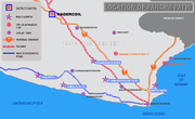
. The closest major cities are Nagercoil
, the administrative headquarters of Kanyakumari District
, (22 km (14 mi)) and Thiruvananthapuram
, the capital of Kerala
(85 km (53 mi)).
The town is a popular tourist place in India.
, the Bay of Bengal
and the Indian Ocean
. In his work on ancient India, Ptolemy had identified Kanyakumari (Cape Comorin) along with the Gulf of Mannar as a center for pearl fishery. He also identifies Korkai, a place to the east of Kanyakumari as an emporium of pearl trade, also Travancore Census 1931 says that Paravars ruled that Coast and built the temple for their reverence to Sea Goddess.
s, the Pandyas
and the Nayak
s. The architectural beauty of the temples in the area are the works of these rulers. Later Kanyakumari became part of the Venad
kingdom with its capital at Padmanabhapuram
. The king of Venad, Anizham Thirunal Marthanda Varma
, established Travancore
by extending his domain further north up to Azhva, during his reign from 1729 to 1758. By this, the present Kanyakumari District came to be known as Southern Travancore. In 1741, Maharaja Marthanda Varma
defeated the Dutch East India Company at the famous Battle of Colachel
.
Kanyakumari was under the rule of the Paravar Kings till the downfall of Pandyas, and later by kings of Travancore under the overall suzerainty of the British until 1947, when India became independent. Travancore joined the independent Indian Union in 1947. The reign of the Travancore royals came to an end.
Under Travancore
rule, the town, and the modern administrative district that bears its name, Kanyakumari District
, progressed both socially and economically. Still a significant part of population study and speak Malayalam as their mother-tongue. The culture followed by Kanyakumari people is mixed and has more influence from Travancore
.
In 1949, Kanyakumari became part of the reconstituted Travancore-Cochin State. Around this time, a popular agitation for the amalgamation of Kanyakumari District with Tamil Nadu by the Tamil-speaking people of the district intensified, under the leadership of Marshal Nesamony
Kumari Thanthai Marshal Nesamony was instrumental in the merger of Kanyakumari district with Tamil Nadu in 1956 during the linguistic reorganisation of states. Kanyakumari was integrated with Tamil Nadu (then known as Madras State) as per the language-based reorganisation of States.
Christianity arrived in South India around AD 52 through St. Thomas, one of the twelve Apostles of Christ. However, European missionaries, who arrived in the 16th century, propagated Christianity in the area. St. Francis Xavier (April 7, 1506 – December 2, 1552) was the pioneer in preaching Christianity in the present day Kanyakumari district. Islam is believed to have entered the southern part of India through Kanyakumari during the early part of the eighth century AD through traders and missionaries who came through sea-routes. Islam, Christianity and Jainism
have also contributed to the architectural wealth and literary heritage of the region.
 Kanniyakumari is located at 8.08°N 77.57°E. It has an average elevation of 0 metres. It lies at the meeting point of three bodies of water
: the Arabian Sea
, the Gulf of Mannar
and the Indian Ocean
. It is situated at 8° 4′ 41″ N, 77° 32′ 28″ E, and is the terminating point of the Western Ghats
and Eastern Ghats
. On the north and the east, it is bounded by Tirunelveli District
, while on the west and northwest it is bounded by Kerala state.
It is suggested that there once existed a continent called Kumari Kandam
to the south of Kanyakumari, often compared with Lemuria
.
, Kanyakumari town had a native population of 19,678.
Kanyakumari is the southernmost town of the Indian mainland. The land mass in and around the town are hilly and uneven, with many commercial buildings and hotels at the upper crest of the land mass with the sea visible below. The old areas of the town, where the natives live, are on the lower side. Many of the natives are into fishing activity and other maritime professions.
Tourism is one of the main activities of the town ; and many locals are employed in shell-craft and other tourism-related businesses.
It has a literacy rate of 98.6%. 40% or more are college degree holders.
Of late, the promotion of tourism has increased, with attractions that do not include the town, such as the surrounding landscapes, as well as the historical and religious sites found around the district, being emphasised to a greater degree. Ultimately a total of 1.9 million tourists (domestic and foreign) visited Kanyakumari in 2007.
Though there are several places of tourist-interest in the town and district, Kanyakumari is especially popular in India for its spectacular and unique sunrise and sunset. The confluence of three ocean bodies – the Bay of Bengal, the Indian Ocean, and the Arabian Sea – makes the sunrise and sunset even more special. On balmy, full-moon evenings, (locally called Chitra Pournami) one can also see the moon-rise and sunset at the same time – on both sides of the
, situated overlooking the shore, attract tourists from all over the world. The sparkling diamond nose-ring of the deity is said to be visible even from the sea.
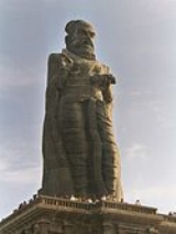
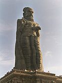
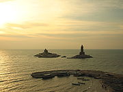
On two rocky islets just off the shore, southeast of the Kumari Amman temple, are the Vivekananda Rock Memorial
, built in 1970, and the gigantic 133 feet (41 m) tall statue of Tamil
saint-poet Thiruvalluvar (Completed on January 1, 2000 by the legandary Dr. V. Ganapati Sthapati, Chennai) is one of the biggest statues in Asia. One of the rocks called Sri Padhaparai is said to bear the footprints of the virgin goddess. Swami Vivekananda
is said to have meditated on this rock for three days. Also on this rock, there is a Dhyana
mandapam, an area for meditation. Ferry services are available to reach the memorial.
The Gandhi Memorial has been built on the spot where the urn containing the Mahatma's ashes was kept for public viewing before immersion. Resembling central Indian Hindu temples in form, the memorial was designed in such a way that on Mahatma Gandhi's birthday, 2 October, the first rays of the sun fall on the exact place where his ashes were kept.
and Thiruvalluvar statue, situated on rocky islets off the coast.
Kanyakumari is directly connected by rail with almost all metropolitan cities in India.
Nearest Airport is Thiruvananthapuram International Airport, 90 km (56 mi) away from Kanyakumari Town and 70 km (43 mi) from Nagercoil
. Kanyakumari is 726 km (451 mi) away from Chennai
 While Kanyakumari town has tourist attractions of its own, the district has many more, from centuries-old historic and religious sites to scenic places. The district is also rich in flora and fauna. A unique feature of Kanyakumari district is that it has all kinds of natural eco-systems. Thus, one can see beaches, mountain valleys, evergreen forests in the deep interior, rubber and clove plantations on the highlands, etc. – all in a 50 km (31 mi) radius of Nagercoil
, the administrative headquarters of Kanyakumari District
. Nagercoil is 20 km (12 mi) from Kanyakumari town. (see Kanyakumari District
for more on the district).
The following are some of the many popular tourist attractions around Kanyakumari –
From the shore where the fishing boats are moored you can see the three towering spires of this off-white Gothic structure with a distinct Portuguese feel. The Church of Our Lady of Ransom is a more than 100-year-old building dedicated to Mother Mary. But what catches your eye first-up is the 153-foot-high (46 meters) central tower crowned with a Cross of pure gold. Truly a beautiful structure; the church looks particularly gorgeous against the molten-blue noon sky. Astonishingly, the grand Gothic façade is a striking contrast to its almost bare interiors.
Once you tread in you will be goggled by its hollowness; no pews anywhere in sight, only a beautiful idol of Mother Mary clad in a sari – like in most South Indian churches – and a little Cross on the altar. This emptiness is further accentuated by colorful light patterns thrown by the stained-glass windows on the bare floor. And one is given to wonder that the church is probably no longer functional! On the contrary, in fact, the church holds mass regularly on the floor made of sand. Since the parish here predominantly comprise local fishing folks, mass is always held in the regional language Tamil.
Town
A town is a human settlement larger than a village but smaller than a city. The size a settlement must be in order to be called a "town" varies considerably in different parts of the world, so that, for example, many American "small towns" seem to British people to be no more than villages, while...
in the state
States and territories of India
India is a federal union of states comprising twenty-eight states and seven union territories. The states and territories are further subdivided into districts and so on.-List of states and territories:...
of Tamil Nadu
Tamil Nadu
Tamil Nadu is one of the 28 states of India. Its capital and largest city is Chennai. Tamil Nadu lies in the southernmost part of the Indian Peninsula and is bordered by the union territory of Pondicherry, and the states of Kerala, Karnataka, and Andhra Pradesh...
in India
India
India , officially the Republic of India , is a country in South Asia. It is the seventh-largest country by geographical area, the second-most populous country with over 1.2 billion people, and the most populous democracy in the world...
. It is also sometimes referred to as Cape Comorin. Located at the southernmost tip of the Indian Peninsula, it is the geographical end of the Indian mainland. The district in Tamil Nadu where the town is located is called Kanyakumari District
Kanyakumari District
Kanyakumari District ) is a district of Tamil Nadu state, India and is the southernmost land area of mainland India.The district is the second most urbanised district in Tamilnadu, next only to Chennai and ahead of Coimbatore. It also has the highest literacy and education levels in the...
. The closest major cities are Nagercoil
Nagercoil
Nagercoil is the 12th largest city in the southernmost Indian state of Tamil Nadu and a municipality and administrative headquarters of Kanyakumari District...
, the administrative headquarters of Kanyakumari District
Kanyakumari District
Kanyakumari District ) is a district of Tamil Nadu state, India and is the southernmost land area of mainland India.The district is the second most urbanised district in Tamilnadu, next only to Chennai and ahead of Coimbatore. It also has the highest literacy and education levels in the...
, (22 km (14 mi)) and Thiruvananthapuram
Thiruvananthapuram
Thiruvananthapuram , formerly known as Trivandrum, is the capital of the Indian state of Kerala and the headquarters of the Thiruvananthapuram District. It is located on the west coast of India near the extreme south of the mainland...
, the capital of Kerala
Kerala
or Keralam is an Indian state located on the Malabar coast of south-west India. It was created on 1 November 1956 by the States Reorganisation Act by combining various Malayalam speaking regions....
(85 km (53 mi)).
The town is a popular tourist place in India.
Recorded history
Kanyakumari takes its name from the Kumari Amman or Kanyakumari Temple, situated in the town, on the sea-shore, the very confluence of the three water-bodies – the Arabian SeaArabian Sea
The Arabian Sea is a region of the Indian Ocean bounded on the east by India, on the north by Pakistan and Iran, on the west by the Arabian Peninsula, on the south, approximately, by a line between Cape Guardafui in northeastern Somalia and Kanyakumari in India...
, the Bay of Bengal
Bay of Bengal
The Bay of Bengal , the largest bay in the world, forms the northeastern part of the Indian Ocean. It resembles a triangle in shape, and is bordered mostly by the Eastern Coast of India, southern coast of Bangladesh and Sri Lanka to the west and Burma and the Andaman and Nicobar Islands to the...
and the Indian Ocean
Indian Ocean
The Indian Ocean is the third largest of the world's oceanic divisions, covering approximately 20% of the water on the Earth's surface. It is bounded on the north by the Indian Subcontinent and Arabian Peninsula ; on the west by eastern Africa; on the east by Indochina, the Sunda Islands, and...
. In his work on ancient India, Ptolemy had identified Kanyakumari (Cape Comorin) along with the Gulf of Mannar as a center for pearl fishery. He also identifies Korkai, a place to the east of Kanyakumari as an emporium of pearl trade, also Travancore Census 1931 says that Paravars ruled that Coast and built the temple for their reverence to Sea Goddess.
Myths and legends
There are multiple myths revolving around this place:- According to Hindu legend, Kanya Devi, an AvatarAvatarIn Hinduism, an avatar is a deliberate descent of a deity to earth, or a descent of the Supreme Being and is mostly translated into English as "incarnation," but more accurately as "appearance" or "manifestation"....
of Parvati, was to marry Siva, but as he failed to show up on his wedding day, the rice and other grains meant for the wedding feast remained uncooked and remain unused thereafter. As the legend goes, the uncooked grains turned into stones as time went by. Some believe that the small stones which look like rice on the shore today, are indeed grains of the wedding that was never solemnized. Kanya Devi is now considered a virgin goddess who blesses pilgrims and tourists who flock the town.
- According to another Hindu legend, Lord HanumanHanumanHanuman , is a Hindu deity, who is an ardent devotee of Rama, a central character in the Indian epic Ramayana and one of the dearest devotees of lord Rama. A general among the vanaras, an ape-like race of forest-dwellers, Hanuman is an incarnation of the divine and a disciple of Lord Rama in the...
dropped a piece of earth as he was carrying a mountain with his life-saving herb, Mrita Sanjivani, from the Himalayas to Lanka (Sri LankaSri LankaSri Lanka, officially the Democratic Socialist Republic of Sri Lanka is a country off the southern coast of the Indian subcontinent. Known until 1972 as Ceylon , Sri Lanka is an island surrounded by the Indian Ocean, the Gulf of Mannar and the Palk Strait, and lies in the vicinity of India and the...
) during the Rama-Ravana war. This chunk of earth is called Marunthuvazh MalaiMarunthuvazh MalaiThe Marunthuvazh Malai also known as the Maruthuva Malai,nearer to VAIKUNDA PATHI forms the part and the southernmost tip of the Western Ghats....
, which is literally translated to "hills where medicine lives".This is said to be the reason for the abundance of unique native medicinal plants in the area. Marunthuvazh MalaiMarunthuvazh MalaiThe Marunthuvazh Malai also known as the Maruthuva Malai,nearer to VAIKUNDA PATHI forms the part and the southernmost tip of the Western Ghats....
is located near Kottaram about 7 km (4 mi) from Kanyakumari town on the Kanyakumari-Nagercoil highway.
- The sage Agasthya, who was himself an expert in medicinal herbs, is believed to have lived around this site in ancient days. The reason why, some believe, so many medicinal herbs are to be found on these hills near Kanyakumari. There is even a village by the name AgastheeswaramAgastheeswaramAgastheeswaram is a panchayat town in Kanniyakumari district in the Indian state of Tamil Nadu.-Demographics: India census, Agastheeswaram had a population of 8978. Males constitute 49% of the population and females 51%. Agastheeswaram has an average literacy rate of 84%, higher than the national...
close to the town, named after the sage. Today, there is a small AshramAshramTraditionally, an ashram is a spiritual hermitage. Additionally, today the term ashram often denotes a locus of Indian cultural activity such as yoga, music study or religious instruction, the moral equivalent of a studio or dojo....
on the middle of the Maruthuvazh Malai hill, which tourists visit (after a short trek from the base of the hill), both to visit the Ashram and also to take a glimpse of the sea near Kanyakumari a few kilometres away, and the greenery below.
Modern history
Kanyakumari has been a great centre for art and religion for centuries. It was also an area of great trade and commerce. It was ruled by the Cholas, the CheraChera dynasty
Chera Dynasty in South India is one of the most ancient ruling dynasties in India. Together with the Cholas and the Pandyas, they formed the three principle warring Iron Age Tamil kingdoms in southern India...
s, the Pandyas
Pandyan Kingdom
The Pandyan dynasty was an ancient Tamil dynasty. The Pandyas were one of the four Tamil dynasties , which ruled South India until the 15th century CE. They initially ruled their country Pandya Nadu from Korkai, a seaport on the Southernmost tip of the Indian Peninsula, and in later times moved...
and the Nayak
Nayak (ethnic group)
-History and origin:The word nayak means a head of a regiment. This word is derived from the Sanskrit senanayaka, which means head of a regiment. The community trace there descent from the Vaghela Rajputs who converted to Islam in the 12th Century. They established a number of petty states in...
s. The architectural beauty of the temples in the area are the works of these rulers. Later Kanyakumari became part of the Venad
Venad
Venad Swarupam was one of the three prominent late medieval Hindu feudal kingdoms on Malabar Coast, south India, along with Kingdom of Calicut and Kingdom of Cannanore. In the early 14th century, Venad ruler Ravi Varma Kulasekhara had established a short-lived supremacy over southern India...
kingdom with its capital at Padmanabhapuram
Padmanabhapuram
Padmanabhapuram a city and a municipality near Thuckalay in Kanniyakumari district in the Indian state of Tamil Nadu.-History:Padmanabhapuram was the old capital of the princely state of Travancore in India...
. The king of Venad, Anizham Thirunal Marthanda Varma
Marthanda Varma
Marthanda Varma , was the founder of the Indian Hindu feudal kingdom of Travancore from Venad SwaroopamHe ruled from 1729 till his death in 1758, having succeeded his maternal uncle Dharma Raja.King Marthanda Varma is usually credited as the "founder of Kingdom of Travancore" from...
, established Travancore
Travancore
Kingdom of Travancore was a former Hindu feudal kingdom and Indian Princely State with its capital at Padmanabhapuram or Trivandrum ruled by the Travancore Royal Family. The Kingdom of Travancore comprised most of modern day southern Kerala, Kanyakumari district, and the southernmost parts of...
by extending his domain further north up to Azhva, during his reign from 1729 to 1758. By this, the present Kanyakumari District came to be known as Southern Travancore. In 1741, Maharaja Marthanda Varma
Marthanda Varma
Marthanda Varma , was the founder of the Indian Hindu feudal kingdom of Travancore from Venad SwaroopamHe ruled from 1729 till his death in 1758, having succeeded his maternal uncle Dharma Raja.King Marthanda Varma is usually credited as the "founder of Kingdom of Travancore" from...
defeated the Dutch East India Company at the famous Battle of Colachel
Battle of Colachel
The Battle of Colachel was fought on between forces of the Indian kingdom of Travancore and the Dutch East India Company, during the Travancore-Dutch War...
.
Kanyakumari was under the rule of the Paravar Kings till the downfall of Pandyas, and later by kings of Travancore under the overall suzerainty of the British until 1947, when India became independent. Travancore joined the independent Indian Union in 1947. The reign of the Travancore royals came to an end.
Under Travancore
Travancore
Kingdom of Travancore was a former Hindu feudal kingdom and Indian Princely State with its capital at Padmanabhapuram or Trivandrum ruled by the Travancore Royal Family. The Kingdom of Travancore comprised most of modern day southern Kerala, Kanyakumari district, and the southernmost parts of...
rule, the town, and the modern administrative district that bears its name, Kanyakumari District
Kanyakumari District
Kanyakumari District ) is a district of Tamil Nadu state, India and is the southernmost land area of mainland India.The district is the second most urbanised district in Tamilnadu, next only to Chennai and ahead of Coimbatore. It also has the highest literacy and education levels in the...
, progressed both socially and economically. Still a significant part of population study and speak Malayalam as their mother-tongue. The culture followed by Kanyakumari people is mixed and has more influence from Travancore
Travancore
Kingdom of Travancore was a former Hindu feudal kingdom and Indian Princely State with its capital at Padmanabhapuram or Trivandrum ruled by the Travancore Royal Family. The Kingdom of Travancore comprised most of modern day southern Kerala, Kanyakumari district, and the southernmost parts of...
.
In 1949, Kanyakumari became part of the reconstituted Travancore-Cochin State. Around this time, a popular agitation for the amalgamation of Kanyakumari District with Tamil Nadu by the Tamil-speaking people of the district intensified, under the leadership of Marshal Nesamony
Kumari Thanthai Marshal Nesamony was instrumental in the merger of Kanyakumari district with Tamil Nadu in 1956 during the linguistic reorganisation of states. Kanyakumari was integrated with Tamil Nadu (then known as Madras State) as per the language-based reorganisation of States.
Christianity arrived in South India around AD 52 through St. Thomas, one of the twelve Apostles of Christ. However, European missionaries, who arrived in the 16th century, propagated Christianity in the area. St. Francis Xavier (April 7, 1506 – December 2, 1552) was the pioneer in preaching Christianity in the present day Kanyakumari district. Islam is believed to have entered the southern part of India through Kanyakumari during the early part of the eighth century AD through traders and missionaries who came through sea-routes. Islam, Christianity and Jainism
Jainism
Jainism is an Indian religion that prescribes a path of non-violence towards all living beings. Its philosophy and practice emphasize the necessity of self-effort to move the soul towards divine consciousness and liberation. Any soul that has conquered its own inner enemies and achieved the state...
have also contributed to the architectural wealth and literary heritage of the region.
Geography
Body of water
A body of water or waterbody is any significant accumulation of water, usually covering the Earth or another planet. The term body of water most often refers to large accumulations of water, such as oceans, seas, and lakes, but it may also include smaller pools of water such as ponds, puddles or...
: the Arabian Sea
Arabian Sea
The Arabian Sea is a region of the Indian Ocean bounded on the east by India, on the north by Pakistan and Iran, on the west by the Arabian Peninsula, on the south, approximately, by a line between Cape Guardafui in northeastern Somalia and Kanyakumari in India...
, the Gulf of Mannar
Gulf of Mannar
The Gulf of Mannar is a large shallow bay forming part of the Laccadive Sea in the Indian Ocean. It lies between the southeastern tip of India and the west coast of Sri Lanka. A chain of low islands and reefs known as Adam's Bridge, also called Ramsethu, which includes Mannar Island, separates the...
and the Indian Ocean
Indian Ocean
The Indian Ocean is the third largest of the world's oceanic divisions, covering approximately 20% of the water on the Earth's surface. It is bounded on the north by the Indian Subcontinent and Arabian Peninsula ; on the west by eastern Africa; on the east by Indochina, the Sunda Islands, and...
. It is situated at 8° 4′ 41″ N, 77° 32′ 28″ E, and is the terminating point of the Western Ghats
Western Ghats
The Western Ghats, Western Ghauts or the Sahyādri is a mountain range along the western side of India. It runs north to south along the western edge of the Deccan Plateau, and separates the plateau from a narrow coastal plain along the Arabian Sea. The Western Ghats block rainfall to the Deccan...
and Eastern Ghats
Eastern Ghats
The Eastern Ghats or Eastern Ghauts are a discontinuous range of mountains along India's eastern coast. The Eastern Ghats run from West Bengal state in the north, through Orissa and Andhra Pradesh to Tamil Nadu in the south passing some parts of Karnataka. They are eroded and cut through by the...
. On the north and the east, it is bounded by Tirunelveli District
Tirunelveli District
Tirunelveli District is a district of Tamil Nadu state in southern India. The city of Tirunelveli is the district headquarters. A unique feature of this district is that it encompasses all five geographical traditions of Tamil Literature; kurinji , mullai , marudham , neithal and palai...
, while on the west and northwest it is bounded by Kerala state.
It is suggested that there once existed a continent called Kumari Kandam
Kumari Kandam
Kumari Kandam is the name of a supposed sunken landmass referred to in existing ancient Tamil literature...
to the south of Kanyakumari, often compared with Lemuria
Lemuria (continent)
Lemuria is the name of a hypothetical "lost land" variously located in the Indian and Pacific Oceans. The concept's 19th century origins lie in attempts to account for discontinuities in biogeography; however, the concept of Lemuria has been rendered obsolete by modern theories of plate tectonics...
.
Town
India censusCensus
A census is the procedure of systematically acquiring and recording information about the members of a given population. It is a regularly occurring and official count of a particular population. The term is used mostly in connection with national population and housing censuses; other common...
, Kanyakumari town had a native population of 19,678.
Kanyakumari is the southernmost town of the Indian mainland. The land mass in and around the town are hilly and uneven, with many commercial buildings and hotels at the upper crest of the land mass with the sea visible below. The old areas of the town, where the natives live, are on the lower side. Many of the natives are into fishing activity and other maritime professions.
Tourism is one of the main activities of the town ; and many locals are employed in shell-craft and other tourism-related businesses.
It has a literacy rate of 98.6%. 40% or more are college degree holders.
Tourism
Since the early 1970s, tourism has been an important activity in the town. Because of this it is one of the few small towns in South India where one can see many of the different languages of India spoken in the street.Of late, the promotion of tourism has increased, with attractions that do not include the town, such as the surrounding landscapes, as well as the historical and religious sites found around the district, being emphasised to a greater degree. Ultimately a total of 1.9 million tourists (domestic and foreign) visited Kanyakumari in 2007.
Though there are several places of tourist-interest in the town and district, Kanyakumari is especially popular in India for its spectacular and unique sunrise and sunset. The confluence of three ocean bodies – the Bay of Bengal, the Indian Ocean, and the Arabian Sea – makes the sunrise and sunset even more special. On balmy, full-moon evenings, (locally called Chitra Pournami) one can also see the moon-rise and sunset at the same time – on both sides of the
Tourist sites
The Kumari Amman or the Kanyakumari Temple, located on the shore, is a Shakti Peetha dedicated to a manifestation of Parvati, the virgin goddess who did penance to obtain Lord Shiva's hand in marriage. The temple and the adjoining ghatGhats
As used in many parts of South Asia, the term ghat refers to a series of steps leading down to a water body, usually a holy river. In Bengali-speaking regions, this set of stairs can lead down to something as small as a pond or as large as a major river....
, situated overlooking the shore, attract tourists from all over the world. The sparkling diamond nose-ring of the deity is said to be visible even from the sea.
On two rocky islets just off the shore, southeast of the Kumari Amman temple, are the Vivekananda Rock Memorial
Vivekananda Rock Memorial
Vivekananda Rock Memorial is a sacred monument and popular tourist attraction in Vavathurai, Kanyakumari, India. The memorial stands on one of two rocks located about 500 meters off mainland of Vavathurai, India's southernmost tip...
, built in 1970, and the gigantic 133 feet (41 m) tall statue of Tamil
Tamil people
Tamil people , also called Tamils or Tamilians, are an ethnic group native to Tamil Nadu, India and the north-eastern region of Sri Lanka. Historic and post 15th century emigrant communities are also found across the world, notably Malaysia, Singapore, Mauritius, South Africa, Australia, Canada,...
saint-poet Thiruvalluvar (Completed on January 1, 2000 by the legandary Dr. V. Ganapati Sthapati, Chennai) is one of the biggest statues in Asia. One of the rocks called Sri Padhaparai is said to bear the footprints of the virgin goddess. Swami Vivekananda
Swami Vivekananda
Swami Vivekananda , born Narendranath Dutta , was the chief disciple of the 19th century mystic Ramakrishna Paramahansa and the founder of the Ramakrishna Math and the Ramakrishna Mission...
is said to have meditated on this rock for three days. Also on this rock, there is a Dhyana
Dhyana in Hinduism
According to the Hindu Yoga Sutra, written by Patanjali, dhyana is one of the eight limbs of Yoga, ....
mandapam, an area for meditation. Ferry services are available to reach the memorial.
The Gandhi Memorial has been built on the spot where the urn containing the Mahatma's ashes was kept for public viewing before immersion. Resembling central Indian Hindu temples in form, the memorial was designed in such a way that on Mahatma Gandhi's birthday, 2 October, the first rays of the sun fall on the exact place where his ashes were kept.
Tourist information
The state-owned Poompuhar Shipping Corporation runs ferry services between the town and the Vivekananda Rock MemorialVivekananda Rock Memorial
Vivekananda Rock Memorial is a sacred monument and popular tourist attraction in Vavathurai, Kanyakumari, India. The memorial stands on one of two rocks located about 500 meters off mainland of Vavathurai, India's southernmost tip...
and Thiruvalluvar statue, situated on rocky islets off the coast.
Kanyakumari is directly connected by rail with almost all metropolitan cities in India.
Nearest Airport is Thiruvananthapuram International Airport, 90 km (56 mi) away from Kanyakumari Town and 70 km (43 mi) from Nagercoil
Nagercoil
Nagercoil is the 12th largest city in the southernmost Indian state of Tamil Nadu and a municipality and administrative headquarters of Kanyakumari District...
. Kanyakumari is 726 km (451 mi) away from Chennai
Tourist attractions
Nagercoil
Nagercoil is the 12th largest city in the southernmost Indian state of Tamil Nadu and a municipality and administrative headquarters of Kanyakumari District...
, the administrative headquarters of Kanyakumari District
Kanyakumari District
Kanyakumari District ) is a district of Tamil Nadu state, India and is the southernmost land area of mainland India.The district is the second most urbanised district in Tamilnadu, next only to Chennai and ahead of Coimbatore. It also has the highest literacy and education levels in the...
. Nagercoil is 20 km (12 mi) from Kanyakumari town. (see Kanyakumari District
Kanyakumari District
Kanyakumari District ) is a district of Tamil Nadu state, India and is the southernmost land area of mainland India.The district is the second most urbanised district in Tamilnadu, next only to Chennai and ahead of Coimbatore. It also has the highest literacy and education levels in the...
for more on the district).
The following are some of the many popular tourist attractions around Kanyakumari –
- Our lady of Ransom Church situated in Kanyakumari,the place where the missionaries had preached the paravas and converted them to Christianity.The first church in the form of a thatched roof was built here in the early 15th century for venerating Santhosha Madha .The church at present stands 153 m tall and it was 100 years old.The new church was built in Gothic Architecture and it looks fabulous when seen with the seashore background, viewing from Our Lady of Ransom Arch near Church Road entrance.
From the shore where the fishing boats are moored you can see the three towering spires of this off-white Gothic structure with a distinct Portuguese feel. The Church of Our Lady of Ransom is a more than 100-year-old building dedicated to Mother Mary. But what catches your eye first-up is the 153-foot-high (46 meters) central tower crowned with a Cross of pure gold. Truly a beautiful structure; the church looks particularly gorgeous against the molten-blue noon sky. Astonishingly, the grand Gothic façade is a striking contrast to its almost bare interiors.
Once you tread in you will be goggled by its hollowness; no pews anywhere in sight, only a beautiful idol of Mother Mary clad in a sari – like in most South Indian churches – and a little Cross on the altar. This emptiness is further accentuated by colorful light patterns thrown by the stained-glass windows on the bare floor. And one is given to wonder that the church is probably no longer functional! On the contrary, in fact, the church holds mass regularly on the floor made of sand. Since the parish here predominantly comprise local fishing folks, mass is always held in the regional language Tamil.
- Vattakottai FortVattakottai FortVattakottai Fort is a seaside fort near Kanyakumari, the southern tip of India. It was built in the 18th century as a coastal defence-fortification and barracks in the erstwhile Travancore kingdom....
(literally, "circular fort") is an 18th-century fort overlooking the sea, located six kilometres from Kanyakumari. The small historic fort also gives an enchanting view of the sea around and the hills on the other side. - SuchindramSuchindramSuchindram Suchindram Suchindram (Tamil: சுசீந்திரம் is a panchayat town in Kanniyakumari district in the Indian state of Tamil Nadu. It is an important pilgrim centre and the site of the famous Thanumalayan Temple (Tamil: தாணுமாலயன் கோயில்).-Geography:Suchindram is located at...
has the Sthanumalayan temple with a repository of art treasures belonging to several kingdoms. The temple is famous for its ninth-century inscriptions, musical columns, and 6-meter-tall statue of the monkey god Hanuman. The main deity in the form of a shivlinga represents Shiva, VishnuVishnuVishnu is the Supreme god in the Vaishnavite tradition of Hinduism. Smarta followers of Adi Shankara, among others, venerate Vishnu as one of the five primary forms of God....
, and BrahmaBrahmaBrahma is the Hindu god of creation and one of the Trimurti, the others being Vishnu and Shiva. According to the Brahma Purana, he is the father of Mānu, and from Mānu all human beings are descended. In the Ramayana and the...
, the trinity of the Hindu pantheon. - The Panchappathi, five primary sacred places of AyyavazhiAyyavazhiAyyavazhi is a dharmic belief system that originated in South India in the 19th century. It is cited as an independent monistic religion by several newspapers, government reports and academic researchers. In Indian censuses, however, the majority of its followers declare themselves as Hindus...
are all situated within a fifteen-kilometre radius of Kanyakumari. It also includes the Swamithope Pathi (headquarters of AyyavazhiAyyavazhiAyyavazhi is a dharmic belief system that originated in South India in the 19th century. It is cited as an independent monistic religion by several newspapers, government reports and academic researchers. In Indian censuses, however, the majority of its followers declare themselves as Hindus...
), a famous temple in Tamil NaduTamil NaduTamil Nadu is one of the 28 states of India. Its capital and largest city is Chennai. Tamil Nadu lies in the southernmost part of the Indian Peninsula and is bordered by the union territory of Pondicherry, and the states of Kerala, Karnataka, and Andhra Pradesh...
, situated ten kilometres to the northwest. It is not structurally massive temple, but is known for its non-idolatry system of worship. - NagercoilNagercoilNagercoil is the 12th largest city in the southernmost Indian state of Tamil Nadu and a municipality and administrative headquarters of Kanyakumari District...
has the St. Francis Xavier's church at KottarKottarKottar is a locality and a thriving bazaar area of Nagercoil, Tamil Nadu state, India; though a part of Nagercoil today, it is the original town around which the city of Nagercoil, near the southernmost tip of Peninsular India, grew. It was an ancient trade center of both Pandyas and Cheras at...
, where the missionary, St. Francis Xavier resided when he did his missionary work in the nearby areas. In Nagercoil, there is also the Nagaraja Temple, and shrines dedicated to Lord ShivaShivaShiva is a major Hindu deity, and is the destroyer god or transformer among the Trimurti, the Hindu Trinity of the primary aspects of the divine. God Shiva is a yogi who has notice of everything that happens in the world and is the main aspect of life. Yet one with great power lives a life of a...
and VishnuVishnuVishnu is the Supreme god in the Vaishnavite tradition of Hinduism. Smarta followers of Adi Shankara, among others, venerate Vishnu as one of the five primary forms of God....
. The entrance to this temple is reminiscent of the Chinese architecture of a Buddhist Vihar. - Padmanabhapuram PalacePadmanabhapuram PalacePadmanabhapuram Palace complex is located in at Padmanabhapuram Fort, close to the town of Thuckalay in Kanyakumari District, Tamilnadu, in India. It is about 20 km from Nagercoil, and about 50 kilometers from Thiruvananthapuram, Kerala. The palace complex is inside an old granite...
is a large 17th century palace of the TravancoreTravancoreKingdom of Travancore was a former Hindu feudal kingdom and Indian Princely State with its capital at Padmanabhapuram or Trivandrum ruled by the Travancore Royal Family. The Kingdom of Travancore comprised most of modern day southern Kerala, Kanyakumari district, and the southernmost parts of...
kings, made almost entirely of wood – the only one of its kind in India. - Udayagiri FortUdayagiri Fort- Fort in Tamil Nadu :-Location:The fort in Tamil Nadu is located at a distance of 14 km from Nagercoil town in Kanyakumari District. The fort is situated on the Thiruvananthapuram-Nagercoil National highway at Puliyoorkurichi. This was the most important military barracks of the Travancore...
, built by King Marthanda VarmaMarthanda VarmaMarthanda Varma , was the founder of the Indian Hindu feudal kingdom of Travancore from Venad SwaroopamHe ruled from 1729 till his death in 1758, having succeeded his maternal uncle Dharma Raja.King Marthanda Varma is usually credited as the "founder of Kingdom of Travancore" from...
, has a foundry for casting guns. It is also the tomb-site of the king's trusted European general Captain De LennoyEustachius De LannoyEustachius Benedictus de Lannoy was a Flemish naval commander of the Dutch East India Company, who was sent by the company to help establish a trading post at Colachel, Southern India, but was defeated at the Battle of Colachel by...
. Udayagiri FortUdayagiri Fort- Fort in Tamil Nadu :-Location:The fort in Tamil Nadu is located at a distance of 14 km from Nagercoil town in Kanyakumari District. The fort is situated on the Thiruvananthapuram-Nagercoil National highway at Puliyoorkurichi. This was the most important military barracks of the Travancore...
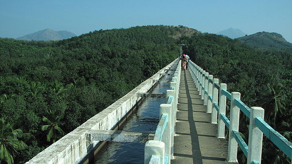
is now a bio-diversity park, administered by the Department of Forests, Kanyakumari Division. - Mathur Hanging Trough, near Thiruvattar in the District, is an aqueduct that carries irrigation water through a canal between two hills. The canal itself goes above a small river. Built on very high pillars, is one of the biggest aqueducts, both in height and length, in Asia. The view from the middle of the aqueduct of the surrounding hills and vegetation, and the small river flowing down below, is breathtaking.
- 'Baywatch' (a water amusement-park), and Wax museum (the only one of its kind in India) are the newest attractions, located within 2 km (1.2 mi) from Kanyakumari.
- Chitharal Jain MonumentsChitharal Jain MonumentsThe Chitharal Jain Monuments are located in a small village situated at a distance of 7 km from Marthandam and 55 km from Kanyakumari. Chitharal is historically known as Thirucharanathupalli – the abode of Jain monks belonging to Digambara sect...
(about 35 km (22 mi) near Marthandam), impressive rock shelters and idols dated 9–11th Century. - Thirunandikkara temple (about 20 km (12 mi)), rock-cut cave temple of Pallava art can be traced back to seventh and eighth century AD.
- Thengapattinam Beach. This beach is located on the west coast near Painkulam village in Vilancode Taluk. It is a fine beach adorned with coconut groves. It is also a magnificent estuary where the river meets the sea. Riding in a catamaran (small boat) in the river can be a pleasant experience which can be arranged through local fishermen. It is 35 km (22 mi) from Nagercoil, 12 km (7 mi) from Kuzhithurai and 54 km (34 mi) from Kanyakumari.
- Olakaruvi waterfalls, about 20 km (12 mi) from Nagercoil is on the middle of a hill and requires an hour's trek by foot from the base of the hill (better to go in a group, as it is a forested area)
- Keeriparai – for nature-lovers and adventurers – pristine and beautiful, places like Keeriparai haven’t been publicized much by the Forest Department for various reasons – Keeriparai hills (30 km (19 mi) from Nagercoil) and the nearby Kalikesam are good picnicPicnicIn contemporary usage, a picnic can be defined simply as a pleasure excursion at which a meal is eaten outdoors , ideally taking place in a beautiful landscape such as a park, beside a lake or with an interesting view and possibly at a public event such as before an open air theatre performance,...
spots – one can enjoy water rushing through small mountain streams – with pebbles and ferns all around. There are also a few small waterfalls in this area – the popular one being Vattaparai FallsVattaparai FallsVattaparai Falls are located at: , elevation , in the Keeriparai reserve forest near Bhoothapandi village on the Pazhayar River in Kanyakumari district, Tamil Nadu state, South India. It is N of Nagercoil) and NW of Kanyakumari...
. Maramalai, which is further up in the hills of Keeriparai is famous for Wild elephants. - Kodhayar (called Kodhayar Lower Camp) – is about 60 km (37 mi) and takes travellers through some exciting motorable hill roads with some thrilling 'hair-pin bends' and U-turns – Kodhayar forests are famous for bisons. Access to some areas need prior permission from the Forest Department.
- Pechiparai ReservoirPechiparai ReservoirPechiparai Reservoir is a reservoir located from the town of Nagercoil, near the village of Pechiparai in Kanyakumari District, Tamil Nadu, India....
, about 30 km (19 mi) from the town, and also Perunchani and Chittar dams). - Thiruparrapu Falls, is a waterfall near Thiruparrapu. There is an ancient temple near the falls, which is popular among the locals and Keralites.
- Muttom, a coastal village, is another popular place with tourists. The terrain in this village and its surroundings is hilly and from a height one can have an idyllic view of the place, with a PortuguesePortugalPortugal , officially the Portuguese Republic is a country situated in southwestern Europe on the Iberian Peninsula. Portugal is the westernmost country of Europe, and is bordered by the Atlantic Ocean to the West and South and by Spain to the North and East. The Atlantic archipelagos of the...
style church standing in the middle of the village. The beach-area is somewhat rocky. There is also a 100-year old lighthouseLighthouseA lighthouse is a tower, building, or other type of structure designed to emit light from a system of lamps and lenses or, in older times, from a fire, and used as an aid to navigation for maritime pilots at sea or on inland waterways....
. The lighthouse, though near the sea, is situated on a land mass some 105 feet (32 m) above sea level. Another attractive feature of this area, is a ravine-like area with casurina trees near the seaside. This place with very popular with Tamil and Keralite film-makers, especially Tamil film director BharathirajaBharathirajaP. Bharathiraja , is a critically acclaimed South Indian filmmaker.He displayed a story-teller's potential from an early age. Bharathiraja is known for his realistic and sensitive portrayal of village-life in his movies....
. - Sanguthurai Beach, about 8 km (5 mi) from Nagercoil is a palm-fringed and sandy beach. Sothavilai Beach is another good beach, about 7 km (4.3 mi)from the heart of town. Both beaches were hit by the Indian Ocean Tsunami, but authorities have taken steps to improve facilities again. There is a lagoonLagoonA lagoon is a body of shallow sea water or brackish water separated from the sea by some form of barrier. The EU's habitat directive defines lagoons as "expanses of shallow coastal salt water, of varying salinity or water volume, wholly or partially separated from the sea by sand banks or shingle,...
at Manakudy – 10 km (6 mi) from the town. - Mukkudal reservoir : Fresh water supply to Nagercoil is from the MukkadalMukkadalMukkadal dam is built across the Vambaru River in the state of Tamil Nadu in southern India, from town of Nagercoil. It is a scenic place, favored as a picnic location among local residents. It was built by Sree Chithira Thirunal Balarama Varma in 1645, the King of Travancore. The dam is...
Reservoir, about 8 km (5 mi) from the town, in the interior – itself a scenic place, with a small bushy island in the middle of the dam. The dam is surrounded by hills of the Western Ghats.