

Northern California
Encyclopedia
Northern California is the northern portion of the U.S. state of California
. The San Francisco Bay Area
(which includes the cities of San Francisco
, Oakland
, and the largest city of the region, San Jose
), and Sacramento
(the state capital) as well as its metropolitan area are the main population centers. It also contains redwood forests, along with the Sierra Nevada including Yosemite Valley
and Lake Tahoe
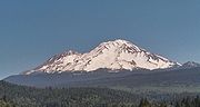
, Mount Shasta
(the second-highest peak in the Cascade Range
after Mount Rainier
in Washington
), and the northern half of the Central Valley, one of the world's most productive agricultural regions.
The area also contains one of the 11 megaregions of the United States
, spanning from the San Francisco Bay Area east to the Lake Tahoe
-Reno
area, and from Metropolitan Fresno
north to Greater Sacramento
.
Native Americans arrived in Northern California at least as early as 8,000 to 5,000 BC and perhaps even much before, and successive waves of arrivals led to one of the most densely populated areas of pre-Columbian North America. The arrival of European explorers from the early 16th to the mid-18th centuries, did not establish European settlements in Northern California. In 1770, the Spanish mission
at Monterey
was the first European settlement in the area, followed by other missions along the coast—eventually extending as far north as Sonoma County.
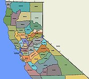 Northern California is not a formal geographic designation, California's north-south midway division is around 37° latitude, near the level of San Francisco. Popularly, though, "Northern California" usually refers to the state's northernmost 48 counties. The term is also applied to the area north of the Tehachapi Mountains
.
Because of California's large size and diverse geography, the state can be subdivided in other ways as well. For example, the Central Valley is a distinct region in itself both culturally and topographically from coastal California, though in Northern versus Southern California divisions, the Sacramento Valley and most of the San Joaquin Valley are usually placed in Northern California.
The state is often considered as having an additional division north of the urban areas of the San Francisco Bay Area
and Sacramento
metropolitan areas. Extreme northern residents have felt under-represented in state government and in 1941 attempted to form a new state with southwestern Oregon to be called Jefferson, or more recently to introduce legislation to split California into two or three states
. The region north of Sacramento is referred by locals as the Northstate. Since 2001, the 20 northernmost counties have promoted the region from Point Arena to Lake Tahoe and northward as Upstate California
.
, Northern California has been a leader on the world's economic, scientific, and cultural stages. From the development of gold mining techniques in the 19th century that were later adopted around the world, to the development of world-famous and online business models (such as Apple, Hewlett-Packard
, Google
, Yahoo!
, and eBay
), Northern California has been at the forefront of new ways of doing business. In science, advances range from being the first
to isolate and name fourteen transuranic chemical element
s, to breakthroughs in microchip technology. Cultural contributions include the works of Ansel Adams
, George Lucas
, and Clint Eastwood
, as well as beatniks, the Summer of Love
, winemaking
, and the open, casual workplace first popularized in the Silicon Valley dot-com boom and now widely in use around the world.
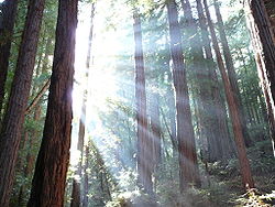
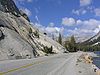
 Northern California's diverse geography ranges from the sandy beaches of the Pacific coast to the rugged, snow-capped Sierra Nevada mountains in the east. The central portion of the region is dominated by the Central Valley
, one of the most vital agricultural areas in the country. The Sierra Nevada contains Yosemite Valley
, famous for its glacially-carved domes, and Sequoia National Park
, home to the largest trees on Earth, the giant sequoia trees, and the highest point in the contiguous United States
, Mount Whitney
. The tallest living things on Earth, the ancient redwood trees, dot the coastline, mainly north of San Francisco. The area is also known for its fertile farm and ranch lands, wine country, the high mountains of the southern Cascade Range
, the Trinity Alps
, and the Klamath Mountains
, lakes, and the windswept sagebrush steppe
, in the northeast portion of the region.
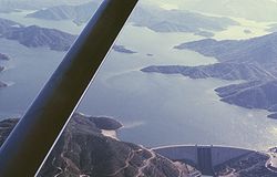
Lake Shasta, located between the north end of the Sacramento Valley and Mount Shasta, is the largest reservoir, and is the third largest body of water after Lake Tahoe
and the Salton Sea
, in California. It was created by the construction of Shasta Dam
across the Sacramento River
, which was completed in 1945.
The climate can be generally characterized by its marine
to warm Mediterranean climate
s along the coast, to somewhat Continental Mediterranean Climate in the valley to alpine climate zones in the high mountains. Apart from the San Francisco Bay Area
and Sacramento metropolitan area
s (and some other cities in the Central Valley), it is a region of relatively low population density.
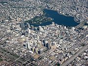
is the San Francisco Bay Area
which includes the cities of San Jose
(3rd largest in California), San Francisco
(4th largest in California), Oakland
, and their many suburbs.
In recent years the Bay Area has drawn more commuters from as far as Central Valley cities such as Sacramento
, Stockton
and Modesto
. With expanding development in all these areas, the San Francisco Bay Area, Monterey Bay Area, and central part of the Central Valley and Sierra Nevada foothills may now be viewed as part of a single megalopolis
. The 2010 U.S. Census showed that the Bay Area grew at a faster rate than the Greater Los Angeles Area
while Greater Sacramento had the largest growth rate of any metropolitan area in California.
The state's larger inland cities are considered part of Northern California in cases when the state is divided into two parts. Important cities in the region not in major metropolitan areas include Fresno, Redding
, at the northern end of the Central Valley, Chico
, and Yuba City in the mid-north of the Valley, and Eureka
on the far North Coast. Though smaller in every case except for Fresno than the larger cities of the vast region, these smaller regional centers are often of historical, and perhaps inflated economic importance for their respective size, due to their locations, which are primarily rural or otherwise isolated.
 The following are major central business districts:
, from the Shasta
tribe in the north, to the Miwok
s in the central coast and Sierra Nevada, to the Yokuts of the southern Central Valley, Northern California was among the most densely populated areas of pre-Columbian North America.
, sailing for the Spanish Crown; in 1542, Cabrillo's expedition sailed perhaps as far north as the Rogue River
in today's Oregon
. Beginning in 1565, the Spanish Manila galleon
s crossed the Pacific Ocean from Mexico
to the Spanish Philippines
, with silver and gemstones from Mexico. The Manila galleons returned across the northern Pacific, and reached North America usually off the coast of Northern California, and then continued south with their Asian trade goods to Mexico.
In 1579, Northern California was visited by the English explorer Sir Francis Drake who landed north of today's San Francisco and claimed the area for England. In 1602, the Spaniard Sebastián Vizcaíno
explored California's coast as far north as Monterey Bay
, where he went ashore. Other Spanish explorers sailed along the coast of Northern California for the next 150 years, but no settlements were established.
along the California coast. The mission at Monterey
was first established in 1770, and at San Francisco
in 1776. In all, ten missions stretched along the coast from Sonoma
to Monterey (and still more missions to the southern tip of Baja California
). In 1786, the French
signaled their interest in the Northern California area by sending a voyage of exploration to Monterey.
The first twenty years of the 19th century continued the colonization of the Northern California coast by Spain. By 1820, Spanish influence extended inland approximately 25 to 50 miles (80 km) from the missions. Outside of this zone, perhaps 200,000 to 250,000 Native Americans continued to lead traditional lives. The Adams-Onís Treaty
, signed in 1819 between Spain and the young United States, set the northern boundary of the Spanish claims at the 42nd parallel, effectively creating today's northern boundary of Northern California.
, were moving down the coast, and in 1812 established Fort Ross, a fur trading outpost on the coast of today's Sonoma County. Fort Ross was the southernmost point of expansion, meeting the Spanish northern expansion some 70 miles (113 km) north of San Francisco. In 1841, as the American presence in Northern California began to increase and politics began to change the region, a deal was made with John Sutter
and the Russians abandoned their Northern California settlements.
from Spain in 1821, Mexico continued Spain's missions and settlements in Northern California as well as Spain's territorial claims. The Mexican Californio
s (Spanish-speaking Californians) in these settlements primarily traded cattle hides and tallow
with American and European merchant vessels.
 In 1825, the Hudson's Bay Company
established a major trading post just north
of today's Portland, Oregon
. British fur trappers and hunters then used the Siskiyou Trail
to travel throughout Northern California. The leader of a further French scientific expedition to Northern California, Eugene Duflot de Mofras
, wrote in 1840 "...it is evident that California will belong to whatever nation chooses to send there a man-of-war and two hundred men." By the 1830s, a significant number of non-Californios had immigrated to Northern California. Chief among these was John Sutter
, a European immigrant from Switzerland
, who was granted 48827 acres (197.6 km²) centered
on the area of today's Sacramento
.
led a herd of horses and mules over the Siskiyou Trail
from missions in Northern California to British and American settlements in Oregon
. Although a small number of American traders and trappers had lived in Northern California since the early 1830s, the first organized overland party of American immigrants to arrive in Northern California was the Bartleson-Bidwell Party
of 1841 via the new California Trail
. Also in 1841, an overland exploratory party of the United States Exploring Expedition
came down the Siskiyou Trail
from the Pacific Northwest. In 1846, the Donner Party
earned notoriety as they struggled to enter Northern California.
" of the California Republic
over Sonoma. The "Bear Flag Republic" lasted only 26 days, until the U.S. Army, led by John Frémont, took over on July 9. The California state flag today is based on this original Bear Flag, and continues to contain the words "California Republic."
Commodore John Drake Sloat ordered his naval forces to occupy Yerba Buena
(present San Francisco) on July 7 and within days American forces controlled San Francisco, Sonoma, and Sutter's Fort
in Sacramento. The treaty
ending the Mexican-American War was signed on February 2, 1848, and Mexico formally ceded Alta California
(including all of present-day Northern California) to the United States.
took place almost exclusively in Northern California from 1848–1855. It began on January 24, 1848, when gold
was discovered at Sutter's Mill
in Coloma
. News of the discovery soon spread, resulting in some 300,000 people coming to California from the rest of the United States and abroad. San Francisco
grew from a tiny hamlet of tents to a boomtown
, and roads, churches, schools and other towns were built. New methods of transportation developed as steamships came into regular service and railroads
were built. However, the Gold Rush also had negative effects: Native Americans
were attacked and pushed off traditional lands, and gold mining
caused environmental harm.
The Gold Rush also increased pressure to make California a U.S. state
. Pro-slavery politicians initially attempted to permanently divide Northern and Southern California at 36 degrees, 30 minutes, the line of the Missouri Compromise
. But instead, the passing of the Compromise of 1850
enabled California to be admitted to the Union as a free state.
in 1869, with its terminus in Sacramento, meant that Northern California's agricultural produce (and some manufactured goods) could now be shipped economically to the rest of the United States. In return, immigrants from the rest of the United States (and Europe) could comfortably come to Northern California. A network of railroads spread throughout Northern California, and in 1887, a rail link
was completed to the Pacific Northwest
. Almost all of these railways came under the control of the Southern Pacific Railroad
, headquartered in San Francisco, and San Francisco continued as a financial and cultural center.
Substantial tensions during this era included nativist sentiments (primarily against Chinese immigrants), tensions between the increasing power of the Southern Pacific Railroad and small farmers, and the beginnings of the labor union movement.
), as well as being known for clean power
, biomedical, government, and finance. Other significant industries include tourism, shipping, and agriculture. Its economy is diverse, though more concentrated in high technology, and subject to the whims of venture capital
than any other major regional economy in the nation especially within Silicon Valley
, and less dependent on oil and residential housing than Southern California
. It is home to the state capital, as well as several Western United States regional offices in San Francisco, such as the Federal Reserve and 9th Circuit Court
. San Francisco is the city with the highest economic significance, however, Santa Clara County's numerous cities together play a very significant if not more significant role than San Francisco.
Other major economic centers include Oakland and Sacramento
.
The largest percentage increase outside the Gold Rush era (51%) came in the decade of the 1940s, as the area was the destination of many post-War veterans and their families, attracted by the greatly expanding industrial base and (often) by their time stationed in Northern California during World War II. The largest absolute increase occurred during the decade of 1980s (over 2.1 million person increase), attracted to job opportunities in part by the expansion taking place in Silicon Valley
and the Cold War
era expansion of the defense industry. The 2010 U.S. Census revealed that Northern California grew at a faster rate than Southern California in the 2000s with a rate slightly higher than the state average.
and University of California, Berkeley
. Top-tier public graduate schools include Boalt Hall and Hastings
law schools and UC San Francisco
, a top-ranked medical school.
, which is displayed on the reverse side of the California state quarter. Other prominent parks are the Kings Canyon
-Sequoia National Park
complex, Redwood National Park, Lassen Volcanic National Park
and the largest in the contiguous forty-eight states, Death Valley National Park
.
, Giant Sequoia National Monument
, Devils Postpile National Monument
, Lava Beds National Monument
, Pinnacles National Monument
, Point Reyes National Seashore
, the Monterey Bay National Marine Sanctuary
, and the Cordell Bank
and Gulf of the Farallones
National Marine Sanctuaries (both off the coast of San Francisco). Included within the latter National Marine Sanctuary is the Farallon National Wildlife Refuge; this National Wildlife Refuge
is one of approximately twenty-five such refuges in Northern California. National forests
occupy large sections of Northern California, including the Shasta-Trinity
, Klamath
, Modoc
, Lassen
, Mendocino
, Eldorado
, Tahoe
, and Sequoia
national forests, among others. Included within (or adjacent to) national forests are federally protected wilderness areas, including the Trinity Alps
, Castle Crags
, Granite Chief, and Desolation
wilderness areas.
In addition, the California Coastal National Monument
protects all islets, reefs, and rock outcroppings from the shore of Northern California out to a distance of 12 nautical miles (22.22 km), along the entire Northern California coastline. In addition, the National Park Service administers protected areas on Alcatraz Island
, the Golden Gate
National Recreation Area
, and the Whiskeytown National Recreation Area. The NPS also administers the Manzanar
National Historic Site
in Inyo County, and the Rosie the Riveter/World War II Home Front National Historical Park
in the San Francisco Bay Area.
Transportation in Alameda County
Transportation in Alpine County
Transportation in Amador County
Transportation in Butte County
Transportation in Calaveras County
Transportation in Colusa County
Transportation in Contra Costa County
Transportation in Del Norte County
Transportation in El Dorado County
Transportation in Fresno County
Transportation in Glenn County
Transportation in Humboldt County
Transportation in Inyo County
Transportation in Kings County
Transportation in Lake County
Transportation in Lassen County
Transportation in Madera County
Transportation in Marin County
Transportation in Mariposa County
Transportation in Mendocino County
Transportation in Merced County
Transportation in Modoc County
Transportation in Mono County
Transportation in Monterey County
Transportation in Napa County
Transportation in Nevada County
Transportation in Oakland
Transportation in Placer County
Transportation in Plumas County
Transportation in Sacramento
Transportation in Sacramento County
Transportation in San Benito County
Transportation in the San Francisco Bay Area
Transportation in San Francisco
Transportation in San Joaquin County
Transportation in San Mateo County
Transportation in Santa Clara County
Transportation in Santa Cruz County
Transportation in Shasta County
Transportation in Sierra County
Transportation in Siskiyou County
Transportation in Solano County
Transportation in Sonoma County
Transportation in Stanislaus County
Transportation in Sutter County
Transportation in Tehama County
Transportation in Trinity County
Transportation in Tulare County
Transportation in Tuolumne County
Transportation in Yolo County
Transportation in Yuba County
 The following airports currently have regularly scheduled commercial service:
U.S. Routes:
 Principal State highways:
California
California is a state located on the West Coast of the United States. It is by far the most populous U.S. state, and the third-largest by land area...
. The San Francisco Bay Area
San Francisco Bay Area
The San Francisco Bay Area, commonly known as the Bay Area, is a populated region that surrounds the San Francisco and San Pablo estuaries in Northern California. The region encompasses metropolitan areas of San Francisco, Oakland, and San Jose, along with smaller urban and rural areas...
(which includes the cities of San Francisco
San Francisco, California
San Francisco , officially the City and County of San Francisco, is the financial, cultural, and transportation center of the San Francisco Bay Area, a region of 7.15 million people which includes San Jose and Oakland...
, Oakland
Oakland, California
Oakland is a major West Coast port city on San Francisco Bay in the U.S. state of California. It is the eighth-largest city in the state with a 2010 population of 390,724...
, and the largest city of the region, San Jose
San Jose, California
San Jose is the third-largest city in California, the tenth-largest in the U.S., and the county seat of Santa Clara County which is located at the southern end of San Francisco Bay...
), and Sacramento
Sacramento, California
Sacramento is the capital city of the U.S. state of California and the county seat of Sacramento County. It is located at the confluence of the Sacramento River and the American River in the northern portion of California's expansive Central Valley. With a population of 466,488 at the 2010 census,...
(the state capital) as well as its metropolitan area are the main population centers. It also contains redwood forests, along with the Sierra Nevada including Yosemite Valley
Yosemite Valley
Yosemite Valley is a glacial valley in Yosemite National Park in the western Sierra Nevada mountains of California, carved out by the Merced River. The valley is about long and up to a mile deep, surrounded by high granite summits such as Half Dome and El Capitan, and densely forested with pines...
and Lake Tahoe
Lake Tahoe
Lake Tahoe is a large freshwater lake in the Sierra Nevada of the United States. At a surface elevation of , it is located along the border between California and Nevada, west of Carson City. Lake Tahoe is the largest alpine lake in North America. Its depth is , making it the USA's second-deepest...
, Mount Shasta
Mount Shasta
Mount Shasta is located at the southern end of the Cascade Range in Siskiyou County, California and at is the second highest peak in the Cascades and the fifth highest in California...
(the second-highest peak in the Cascade Range
Cascade Range
The Cascade Range is a major mountain range of western North America, extending from southern British Columbia through Washington and Oregon to Northern California. It includes both non-volcanic mountains, such as the North Cascades, and the notable volcanoes known as the High Cascades...
after Mount Rainier
Mount Rainier
Mount Rainier is a massive stratovolcano located southeast of Seattle in the state of Washington, United States. It is the most topographically prominent mountain in the contiguous United States and the Cascade Volcanic Arc, with a summit elevation of . Mt. Rainier is considered one of the most...
in Washington
Washington State
Washington State may refer to:* Washington , often referred to as "Washington state" to differentiate it from Washington, D.C., the capital of the United States* Washington State University, a land-grant college in that state- See also :...
), and the northern half of the Central Valley, one of the world's most productive agricultural regions.
The area also contains one of the 11 megaregions of the United States
Megaregions of the United States
A Megaregion, also known as a Megalopolis or Megapolitan Area, refers to a clustered network of American cities whose population ranges or is projected to range from about 7 to 63 million by the year 2025. America 2050, an organization sponsored by the Rockefeller and Ford Foundations, lists 11...
, spanning from the San Francisco Bay Area east to the Lake Tahoe
Lake Tahoe
Lake Tahoe is a large freshwater lake in the Sierra Nevada of the United States. At a surface elevation of , it is located along the border between California and Nevada, west of Carson City. Lake Tahoe is the largest alpine lake in North America. Its depth is , making it the USA's second-deepest...
-Reno
Reno, Nevada
Reno is the county seat of Washoe County, Nevada, United States. The city has a population of about 220,500 and is the most populous Nevada city outside of the Las Vegas metropolitan area...
area, and from Metropolitan Fresno
Metropolitan Fresno
Metropolitan Fresno or officially Fresno-Madera, CA CSA is a metropolitan area in California's Central Valley consisting of Fresno and Madera counties in the southern area of Northern California...
north to Greater Sacramento
Sacramento metropolitan area
The Greater Sacramento area, or officially Sacramento–Arden Arcade–Yuba City, CA-NV Combined Statistical Area, is a combined statistical area consisting of several metropolitan statistical areas and seven counties in Northern California and one in Western Nevada. These are Sacramento, Yolo, El...
.
Native Americans arrived in Northern California at least as early as 8,000 to 5,000 BC and perhaps even much before, and successive waves of arrivals led to one of the most densely populated areas of pre-Columbian North America. The arrival of European explorers from the early 16th to the mid-18th centuries, did not establish European settlements in Northern California. In 1770, the Spanish mission
Spanish missions in California
The Spanish missions in California comprise a series of religious and military outposts established by Spanish Catholics of the Franciscan Order between 1769 and 1823 to spread the Christian faith among the local Native Americans. The missions represented the first major effort by Europeans to...
at Monterey
Monterey, California
The City of Monterey in Monterey County is located on Monterey Bay along the Pacific coast in Central California. Monterey lies at an elevation of 26 feet above sea level. As of the 2010 census, the city population was 27,810. Monterey is of historical importance because it was the capital of...
was the first European settlement in the area, followed by other missions along the coast—eventually extending as far north as Sonoma County.
Description
Tehachapi Mountains
The Tehachapi Mountains , regionally also called The Tehachapis, are a mountain range in the Transverse Ranges system of California in the Western United States...
.
Because of California's large size and diverse geography, the state can be subdivided in other ways as well. For example, the Central Valley is a distinct region in itself both culturally and topographically from coastal California, though in Northern versus Southern California divisions, the Sacramento Valley and most of the San Joaquin Valley are usually placed in Northern California.
The state is often considered as having an additional division north of the urban areas of the San Francisco Bay Area
San Francisco Bay Area
The San Francisco Bay Area, commonly known as the Bay Area, is a populated region that surrounds the San Francisco and San Pablo estuaries in Northern California. The region encompasses metropolitan areas of San Francisco, Oakland, and San Jose, along with smaller urban and rural areas...
and Sacramento
Sacramento, California
Sacramento is the capital city of the U.S. state of California and the county seat of Sacramento County. It is located at the confluence of the Sacramento River and the American River in the northern portion of California's expansive Central Valley. With a population of 466,488 at the 2010 census,...
metropolitan areas. Extreme northern residents have felt under-represented in state government and in 1941 attempted to form a new state with southwestern Oregon to be called Jefferson, or more recently to introduce legislation to split California into two or three states
Partition and secession in California
This article documents historical attempts to split up the state of California, the most populous state in the United States and the third largest in area, since it acquired statehood in 1850. Throughout the state's history, there have been more than 220 attempts to divide California into multiple...
. The region north of Sacramento is referred by locals as the Northstate. Since 2001, the 20 northernmost counties have promoted the region from Point Arena to Lake Tahoe and northward as Upstate California
Upstate California
Upstate California is a region of California consisting of its northernmost 20 counties, most of which are rural. Generally, this area consists of all territory within California north of the San Francisco Bay and Sacramento areas....
.
Significance
Since the events of the California Gold RushCalifornia Gold Rush
The California Gold Rush began on January 24, 1848, when gold was found by James W. Marshall at Sutter's Mill in Coloma, California. The first to hear confirmed information of the gold rush were the people in Oregon, the Sandwich Islands , and Latin America, who were the first to start flocking to...
, Northern California has been a leader on the world's economic, scientific, and cultural stages. From the development of gold mining techniques in the 19th century that were later adopted around the world, to the development of world-famous and online business models (such as Apple, Hewlett-Packard
Hewlett-Packard
Hewlett-Packard Company or HP is an American multinational information technology corporation headquartered in Palo Alto, California, USA that provides products, technologies, softwares, solutions and services to consumers, small- and medium-sized businesses and large enterprises, including...
Google
Google Inc. is an American multinational public corporation invested in Internet search, cloud computing, and advertising technologies. Google hosts and develops a number of Internet-based services and products, and generates profit primarily from advertising through its AdWords program...
, Yahoo!
Yahoo!
Yahoo! Inc. is an American multinational internet corporation headquartered in Sunnyvale, California, United States. The company is perhaps best known for its web portal, search engine , Yahoo! Directory, Yahoo! Mail, Yahoo! News, Yahoo! Groups, Yahoo! Answers, advertising, online mapping ,...
, and eBay
EBay
eBay Inc. is an American internet consumer-to-consumer corporation that manages eBay.com, an online auction and shopping website in which people and businesses buy and sell a broad variety of goods and services worldwide...
), Northern California has been at the forefront of new ways of doing business. In science, advances range from being the first
Lawrence Berkeley National Laboratory
The Lawrence Berkeley National Laboratory , is a U.S. Department of Energy national laboratory conducting unclassified scientific research. It is located on the grounds of the University of California, Berkeley, in the Berkeley Hills above the central campus...
to isolate and name fourteen transuranic chemical element
Chemical element
A chemical element is a pure chemical substance consisting of one type of atom distinguished by its atomic number, which is the number of protons in its nucleus. Familiar examples of elements include carbon, oxygen, aluminum, iron, copper, gold, mercury, and lead.As of November 2011, 118 elements...
s, to breakthroughs in microchip technology. Cultural contributions include the works of Ansel Adams
Ansel Adams
Ansel Easton Adams was an American photographer and environmentalist, best known for his black-and-white photographs of the American West, especially in Yosemite National Park....
, George Lucas
George Lucas
George Walton Lucas, Jr. is an American film producer, screenwriter, and director, and entrepreneur. He is the founder, chairman and chief executive of Lucasfilm. He is best known as the creator of the space opera franchise Star Wars and the archaeologist-adventurer character Indiana Jones...
, and Clint Eastwood
Clint Eastwood
Clinton "Clint" Eastwood, Jr. is an American film actor, director, producer, composer and politician. Eastwood first came to prominence as a supporting cast member in the TV series Rawhide...
, as well as beatniks, the Summer of Love
Summer of Love
The Summer of Love was a social phenomenon that occurred during the summer of 1967, when as many as 100,000 people converged on the Haight-Ashbury neighborhood of San Francisco, creating a cultural and political rebellion...
, winemaking
California wine
California wine has a long and continuing history, and in the late twentieth century became recognized as producing some of the world's finest wine. While wine is made in all fifty U.S. states, up to 90% of American wine is produced in the state...
, and the open, casual workplace first popularized in the Silicon Valley dot-com boom and now widely in use around the world.
Geography and climate
California Central Valley
California's Central Valley is a large, flat valley that dominates the central portion of California. It is home to California's most productive agricultural efforts. The valley stretches approximately from northwest to southeast inland and parallel to the Pacific Ocean coast. Its northern half is...
, one of the most vital agricultural areas in the country. The Sierra Nevada contains Yosemite Valley
Yosemite Valley
Yosemite Valley is a glacial valley in Yosemite National Park in the western Sierra Nevada mountains of California, carved out by the Merced River. The valley is about long and up to a mile deep, surrounded by high granite summits such as Half Dome and El Capitan, and densely forested with pines...
, famous for its glacially-carved domes, and Sequoia National Park
Sequoia National Park
Sequoia National Park is a national park in the southern Sierra Nevada east of Visalia, California, in the United States. It was established on September 25, 1890. The park spans . Encompassing a vertical relief of nearly , the park contains among its natural resources the highest point in the...
, home to the largest trees on Earth, the giant sequoia trees, and the highest point in the contiguous United States
Contiguous United States
The contiguous United States are the 48 U.S. states on the continent of North America that are south of Canada and north of Mexico, plus the District of Columbia....
, Mount Whitney
Mount Whitney
Mount Whitney is the highest summit in the contiguous United States with an elevation of . It is on the boundary between California's Inyo and Tulare counties, west-northwest of the lowest point in North America at Badwater in Death Valley National Park...
. The tallest living things on Earth, the ancient redwood trees, dot the coastline, mainly north of San Francisco. The area is also known for its fertile farm and ranch lands, wine country, the high mountains of the southern Cascade Range
Cascade Range
The Cascade Range is a major mountain range of western North America, extending from southern British Columbia through Washington and Oregon to Northern California. It includes both non-volcanic mountains, such as the North Cascades, and the notable volcanoes known as the High Cascades...
, the Trinity Alps
Trinity Alps
The Trinity Alps are mountains in Northern California, in the Pacific Coast Ranges physiographic region, located to the northwest of Redding. Elevations there range from to at Thompson Peak. The Trinity Alps Wilderness covers , making it the second largest wilderness area in California...
, and the Klamath Mountains
Klamath Mountains
The Klamath Mountains, which include the Siskiyou, Marble, Scott, Trinity, Trinity Alps, Salmon, and northern Yolla-Bolly Mountains, are a rugged lightly populated mountain range in northwest California and southwest Oregon in the United States...
, lakes, and the windswept sagebrush steppe
Steppe
In physical geography, steppe is an ecoregion, in the montane grasslands and shrublands and temperate grasslands, savannas, and shrublands biomes, characterized by grassland plains without trees apart from those near rivers and lakes...
, in the northeast portion of the region.
Lake Shasta, located between the north end of the Sacramento Valley and Mount Shasta, is the largest reservoir, and is the third largest body of water after Lake Tahoe
Lake Tahoe
Lake Tahoe is a large freshwater lake in the Sierra Nevada of the United States. At a surface elevation of , it is located along the border between California and Nevada, west of Carson City. Lake Tahoe is the largest alpine lake in North America. Its depth is , making it the USA's second-deepest...
and the Salton Sea
Salton Sea
The Salton Sea is a shallow, saline, endorheic rift lake located directly on the San Andreas Fault, predominantly in California's Imperial Valley. The lake occupies the lowest elevations of the Salton Sink in the Colorado Desert of Imperial and Riverside counties in Southern California. Like Death...
, in California. It was created by the construction of Shasta Dam
Shasta Dam
Shasta Dam is an arch dam across the Sacramento River in the northern part of the U.S. state of California, at the north end of the Sacramento Valley. The dam mainly serves long-term water storage and flood control in its reservoir, Shasta Lake, and also generates hydroelectric power...
across the Sacramento River
Sacramento River
The Sacramento River is an important watercourse of Northern and Central California in the United States. The largest river in California, it rises on the eastern slopes of the Klamath Mountains, and after a journey south of over , empties into Suisun Bay, an arm of the San Francisco Bay, and...
, which was completed in 1945.
The climate can be generally characterized by its marine
Oceanic climate
An oceanic climate, also called marine west coast climate, maritime climate, Cascadian climate and British climate for Köppen climate classification Cfb and subtropical highland for Köppen Cfb or Cwb, is a type of climate typically found along the west coasts at the middle latitudes of some of the...
to warm Mediterranean climate
Mediterranean climate
A Mediterranean climate is the climate typical of most of the lands in the Mediterranean Basin, and is a particular variety of subtropical climate...
s along the coast, to somewhat Continental Mediterranean Climate in the valley to alpine climate zones in the high mountains. Apart from the San Francisco Bay Area
San Francisco Bay Area
The San Francisco Bay Area, commonly known as the Bay Area, is a populated region that surrounds the San Francisco and San Pablo estuaries in Northern California. The region encompasses metropolitan areas of San Francisco, Oakland, and San Jose, along with smaller urban and rural areas...
and Sacramento metropolitan area
Sacramento metropolitan area
The Greater Sacramento area, or officially Sacramento–Arden Arcade–Yuba City, CA-NV Combined Statistical Area, is a combined statistical area consisting of several metropolitan statistical areas and seven counties in Northern California and one in Western Nevada. These are Sacramento, Yolo, El...
s (and some other cities in the Central Valley), it is a region of relatively low population density.
Cities
Northern California's largest metropolitan areaMetropolitan area
The term metropolitan area refers to a region consisting of a densely populated urban core and its less-populated surrounding territories, sharing industry, infrastructure, and housing. A metropolitan area usually encompasses multiple jurisdictions and municipalities: neighborhoods, townships,...
is the San Francisco Bay Area
San Francisco Bay Area
The San Francisco Bay Area, commonly known as the Bay Area, is a populated region that surrounds the San Francisco and San Pablo estuaries in Northern California. The region encompasses metropolitan areas of San Francisco, Oakland, and San Jose, along with smaller urban and rural areas...
which includes the cities of San Jose
San Jose, California
San Jose is the third-largest city in California, the tenth-largest in the U.S., and the county seat of Santa Clara County which is located at the southern end of San Francisco Bay...
(3rd largest in California), San Francisco
San Francisco, California
San Francisco , officially the City and County of San Francisco, is the financial, cultural, and transportation center of the San Francisco Bay Area, a region of 7.15 million people which includes San Jose and Oakland...
(4th largest in California), Oakland
Oakland, California
Oakland is a major West Coast port city on San Francisco Bay in the U.S. state of California. It is the eighth-largest city in the state with a 2010 population of 390,724...
, and their many suburbs.
In recent years the Bay Area has drawn more commuters from as far as Central Valley cities such as Sacramento
Sacramento, California
Sacramento is the capital city of the U.S. state of California and the county seat of Sacramento County. It is located at the confluence of the Sacramento River and the American River in the northern portion of California's expansive Central Valley. With a population of 466,488 at the 2010 census,...
, Stockton
Stockton, California
Stockton, California, the seat of San Joaquin County, is the fourth-largest city in the Central Valley of the U.S. state of California. With a population of 291,707 at the 2010 census, Stockton ranks as this state's 13th largest city...
and Modesto
Modesto, California
Modesto is a city in, and is the county seat of, Stanislaus County, California. With a population of approximately 201,165 at the 2010 census, Modesto ranks as the 18th largest city in the state of California....
. With expanding development in all these areas, the San Francisco Bay Area, Monterey Bay Area, and central part of the Central Valley and Sierra Nevada foothills may now be viewed as part of a single megalopolis
Megalopolis (city type)
A megalopolis is typically defined as a chain of roughly adjacent metropolitan areas. The term was used by Oswald Spengler in his 1918 book, The Decline of the West, and Lewis Mumford in his 1938 book, The Culture of Cities, which described it as the first stage in urban overdevelopment and...
. The 2010 U.S. Census showed that the Bay Area grew at a faster rate than the Greater Los Angeles Area
Greater Los Angeles Area
The Greater Los Angeles Area, or the Southland, is a term used for the Combined Statistical Area sprawled over five counties in the southern part of California, namely Los Angeles County, Orange County, San Bernardino County, Riverside County and Ventura County...
while Greater Sacramento had the largest growth rate of any metropolitan area in California.
The state's larger inland cities are considered part of Northern California in cases when the state is divided into two parts. Important cities in the region not in major metropolitan areas include Fresno, Redding
Redding, California
Redding is a city in far-Northern California. It is the county seat of Shasta County, California, USA. With a population of 89,861, according to the 2010 Census...
, at the northern end of the Central Valley, Chico
Chico, California
Chico is the most populous city in Butte County, California, United States. The population was 86,187 at the 2010 census, up from 59,954 at the time of the 2000 census...
, and Yuba City in the mid-north of the Valley, and Eureka
Eureka, California
Eureka is the principal city and the county seat of Humboldt County, California, United States. Its population was 27,191 at the 2010 census, up from 26,128 at the 2000 census....
on the far North Coast. Though smaller in every case except for Fresno than the larger cities of the vast region, these smaller regional centers are often of historical, and perhaps inflated economic importance for their respective size, due to their locations, which are primarily rural or otherwise isolated.
Selected cities
The following cities and towns in Northern California have more than 50,000 inhabitants.- AlamedaAlameda, CaliforniaAlameda is a city in Alameda County, California, United States. It is located on Alameda Island and Bay Farm Island, and is adjacent to Oakland in the San Francisco Bay. The Bay Farm Island portion of the city is adjacent to the Oakland International Airport. At the 2010 census, the city had a...
(pop. 75,254) - AntiochAntioch, CaliforniaAntioch is a city in Contra Costa County, California. Located in the East Bay region of the San Francisco Bay Area along the San Joaquin-Sacramento River Delta, it is a suburb of San Francisco and Oakland. The city's population was 102,372 at the U.S...
(pop. 100,150) - BerkeleyBerkeley, CaliforniaBerkeley is a city on the east shore of the San Francisco Bay in Northern California, United States. Its neighbors to the south are the cities of Oakland and Emeryville. To the north is the city of Albany and the unincorporated community of Kensington...
(pop. 102,743) - ChicoChico, CaliforniaChico is the most populous city in Butte County, California, United States. The population was 86,187 at the 2010 census, up from 59,954 at the time of the 2000 census...
(pop. 86,187) - Citrus HeightsCitrus Heights, CaliforniaCitrus Heights is a city in Sacramento County, California, USA. As of the 2010 census, the city had a population of 83,301, down from 85,071 at the 2000 census....
(pop. 85,017) - ClovisClovis, CaliforniaClovis is a city in Fresno County, California, United States, northeast of Fresno. The population is estimated to be 97,218 as of September, 2011. Clovis is located northeast of downtown Fresno, at an elevation of 361 feet .-History:...
(pop. 95,128) - ConcordConcord, CaliforniaConcord is the largest city in Contra Costa County, California, USA. At the 2010 census, the city had a population of 122,067. Originally founded in 1869 as the community of Todos Santos by Salvio Pacheco, the name was changed to Concord within months...
(pop. 121,780) - CupertinoCupertino, CaliforniaCupertino is an affluent suburban city in Santa Clara County, California in the U.S., directly west of San Jose on the western edge of the Santa Clara Valley with portions extending into the foothills of the Santa Cruz Mountains. The population was 58,302 at the time of the 2010 census. Forbes...
(pop. 55,162) - Daly CityDaly City, CaliforniaDaly City is the largest city in San Mateo County, California, United States, with a 2010 population of 101,123. Located immediately south of San Francisco, it is named in honor of businessman and landowner John Daly.-History:...
(pop. 103,621) - DavisDavis, CaliforniaDavis is a city in Yolo County, California, United States. It is part of the Sacramento–Arden-Arcade–Roseville Metropolitan Statistical Area...
(pop. 64,938) - Elk GroveElk Grove, CaliforniaElk Grove is a city in Sacramento County, California, located just south of the state capital of Sacramento. It is part of the Sacramento–Arden-Arcade–Roseville Metropolitan Statistical Area. As of the 2010 census, the population of the city is 153,015...
(pop. 141,125) - FairfieldFairfield, CaliforniaFairfield is a city located in Solano County in Northern California, USA. It is generally considered the midpoint between the cities of San Francisco and Sacramento, approximately from the city center of both cities, approximately from the city center of Oakland, less than from Napa Valley, 18...
(pop. 107,593) - FolsomFolsom, CaliforniaFolsom is a city in Sacramento County, California, United States. Folsom is most commonly known for its famous Folsom Prison. The population was 72,203 at the 2010 census....
(pop. 72,590) - FresnoFresno, CaliforniaFresno is a city in central California, United States, the county seat of Fresno County. As of the 2010 census, the city's population was 510,365, making it the fifth largest city in California, the largest inland city in California, and the 34th largest in the nation...
(pop. 505,479) - FremontFremont, CaliforniaFremont is a city in Alameda County, California. It was incorporated on January 23, 1956, from the merger of five smaller communities: Centerville, Niles, Irvington, Mission San Jose, and Warm Springs...
(pop. 213,000) - HanfordHanford, CaliforniaHanford is an important commercial and cultural center in the south central San Joaquin Valley and is the county seat of Kings County, California. It is the principal city of the Hanford-Corcoran, California Metropolitan Statistical Area , which encompasses all of Kings County, including the cities...
(pop. 53,266) - HaywardHayward, CaliforniaHayward is a city located in the East Bay in Alameda County, California. With a population of 144,186, Hayward is the sixth largest city in the San Francisco Bay Area and the third largest in Alameda County. Hayward was ranked as the 37th most populous municipality in California. It is included in...
(pop. 155,312) - LivermoreLivermore, CaliforniaLivermore is a city in Alameda County. The population as of 2010 was 80,968. Livermore is located on the eastern edge of California's San Francisco Bay Area....
(pop. 83,800) - LodiLodi, CaliforniaLodi is a city located in , in the northern portion of California's Central Valley. The population was 62,134 at the 2010 census. The California Department of Finance's population estimate as of January 1, 2011 is 62,473....
(pop. 69,411) - MaderaMadera, CaliforniaMadera is a city in and the county seat of Madera County, California, United States. It is a principal city of the Madera–Chowchilla Metropolitan Statistical Area, which encompasses all of Madera County, and Metropolitan Fresno. It is located in California's San Joaquin Valley. As of the 2010...
(pop. 56,710) - MantecaManteca, CaliforniaManteca is a city in , USA. As of the 2010 census, the city's population was 67,096.- History :Manteca is a city in the Central Valley of California, 76 miles east of San Francisco. It was founded in 1861 by Joshua Cowell. Cowell claimed around and built houses on what is now the corner of Main...
(pop. 66,451) - MercedMerced, CaliforniaMerced is a city in, and the county seat of, Merced County, California in the San Joaquin Valley of Northern California. As of the 2010 census, the city had a population of 78,958. Incorporated in 1889, Merced is a charter city that operates under a council-manager government...
(pop. 80,608)
- MilpitasMilpitas, CaliforniaMilpitas is a city in Santa Clara County, California. It is a suburb of the major city of San Jose, California. It is located with San Jose to its south and Fremont to its north, at the eastern end of State Route 237 and generally between Interstates 680 and 880 which run roughly north/south...
(pop. 66,568) - ModestoModesto, CaliforniaModesto is a city in, and is the county seat of, Stanislaus County, California. With a population of approximately 201,165 at the 2010 census, Modesto ranks as the 18th largest city in the state of California....
(pop. 211,156) - Mountain ViewMountain View, California-Downtown:Mountain View has a pedestrian-friendly downtown centered on Castro Street. The downtown area consists of the seven blocks of Castro Street from the Downtown Mountain View Station transit center in the north to the intersection with El Camino Real in the south...
(pop. 70,708) - NapaNapa, California-History:The name Napa was probably derived from the name given to a southern Nappan village whose people shared the area with elk, deer, grizzlies and cougars for many centuries, according to Napa historian Kami Santiago. At the time of the first recorded exploration into Napa Valley in 1823, the...
(pop. 74,247) - NovatoNovato, CaliforniaNovato is a city located in the North Bay region of the San Francisco Bay Area, in northern Marin County. Novato is located about north-northwest of San Rafael, at an elevation of 30 feet above sea level . The 2010 U.S. Census estimated the city population to be about 51,904. Novato is about ...
(pop. 54,000) - OaklandOakland, CaliforniaOakland is a major West Coast port city on San Francisco Bay in the U.S. state of California. It is the eighth-largest city in the state with a 2010 population of 390,724...
(pop. 415,492) - Palo AltoPalo Alto, CaliforniaPalo Alto is a California charter city located in the northwest corner of Santa Clara County, in the San Francisco Bay Area of California, United States. The city shares its borders with East Palo Alto, Mountain View, Los Altos, Los Altos Hills, Stanford, Portola Valley, and Menlo Park. It is...
(pop. 61,200) - PetalumaPetaluma, CaliforniaPetaluma is a city in Sonoma County, California, in the United States. In the 2010 Census the population was 57,941.Located in Petaluma is the Rancho Petaluma Adobe, a National Historic Landmark. It was built beginning in 1836 by General Mariano Guadalupe Vallejo, then Commandant of the San...
(pop. 60,450) - PittsburgPittsburg, CaliforniaPittsburg is a city located in eastern Contra Costa County, California, the outer portion of the East Bay region of the San Francisco Bay Area. The population was 63,264 at the 2010 census....
(pop. 56,769) - PleasantonPleasanton, CaliforniaPleasanton is a city in Alameda County, California, incorporated in 1894. It is a suburb in the San Francisco Bay Area located about east of Oakland, and west of Livermore. The population was 70,285 at the 2010 census. In 2005 and 2007, Pleasanton was ranked the wealthiest middle-sized city in...
(pop. 71,882) - PortervillePorterville, CaliforniaPorterville is a city in the San Joaquin Valley, in Tulare County, California, United States. Porterville's population was 54,165 at the 2010 census. The city's population grew dramatically as the city annexed many properties and unincorporated areas in and around Porterville. Not included in the...
(pop. 51,467) - Rancho CordovaRancho Cordova, CaliforniaRancho Cordova is a city in Sacramento County, California, USA, that incorporated in 2003. It is part of the Sacramento Metropolitan Area. The population was 64,776 at the 2010 census. Rancho Cordova is the Sacramento area's largest employment sub-center, with a daily influx of over 45,000...
(pop. 60,056) - ReddingRedding, CaliforniaRedding is a city in far-Northern California. It is the county seat of Shasta County, California, USA. With a population of 89,861, according to the 2010 Census...
(pop. 89,861) - Redwood CityRedwood City, CaliforniaRedwood City is a California charter city located on the San Francisco Peninsula in Northern California, approximately 27 miles south of San Francisco, and 24 miles north of San Jose. Redwood City's history spans from its earliest inhabitation by the Ohlone people, to its tradition as a port for...
(pop. 79,000) - RichmondRichmond, CaliforniaRichmond is a city in western Contra Costa County, California, United States. The city was incorporated on August 7, 1905. It is located in the East Bay, part of the San Francisco Bay Area. It is a residential inner suburb of San Francisco, as well as the site of heavy industry, which has been...
(pop. 103,828) - RocklinRocklin, CaliforniaRocklin is a city in Placer County, California located in the metropolitan area of Sacramento. It shares borders with Roseville, Loomis, and Lincoln...
(pop. 54,754) - RosevilleRoseville, California-2010:The 2010 United States Census reported that Roseville had a population of 118,788. The population density was 3,279.4 people per square mile...
(pop. 112,343) - SacramentoSacramento, CaliforniaSacramento is the capital city of the U.S. state of California and the county seat of Sacramento County. It is located at the confluence of the Sacramento River and the American River in the northern portion of California's expansive Central Valley. With a population of 466,488 at the 2010 census,...
(pop. 486,189) - SalinasSalinas, CaliforniaSalinas is the county seat and the largest municipality of Monterey County, California. Salinas is located east-southeast of the mouth of the Salinas River, at an elevation of about 52 feet above sea level. The population was 150,441 at the 2010 census...
(pop. 148,350) - San FranciscoSan Francisco, CaliforniaSan Francisco , officially the City and County of San Francisco, is the financial, cultural, and transportation center of the San Francisco Bay Area, a region of 7.15 million people which includes San Jose and Oakland...
(pop. 808,977) - San JoseSan Jose, CaliforniaSan Jose is the third-largest city in California, the tenth-largest in the U.S., and the county seat of Santa Clara County which is located at the southern end of San Francisco Bay...
(pop. 1,023,083)
- San LeandroSan Leandro, CaliforniaSan Leandro is a city in Alameda County, California, United States. It is considered a suburb of Oakland and San Francisco. The population was 84,950 as of 2010 census. The climate of the city is mild throughout the year.-Geography and water resources:...
(pop. 83,183) - San MateoSan Mateo, CaliforniaSan Mateo is a city in San Mateo County, California, United States, in the San Francisco Bay Area. With a population of approximately 100,000 , it is one of the larger suburbs on the San Francisco Peninsula, located between Burlingame to the north, Foster City to the east, Belmont to the south,...
(pop. 92,482) - San RafaelSan Rafael, CaliforniaSan Rafael is a city and the county seat of Marin County, California, United States. The city is located in the North Bay region of the San Francisco Bay Area...
(pop. 56,063) - San RamonSan Ramon, California-2010 census:The 2010 United States Census reported that San Ramon had a population of 72,148. The population density was 3,991.1 people per square mile...
(pop. 58,035) - Santa ClaraSanta Clara, CaliforniaSanta Clara , founded in 1777 and incorporated in 1852, is a city in Santa Clara County, in the U.S. state of California. The city is the site of the eighth of 21 California missions, Mission Santa Clara de Asís, and was named after the mission. The Mission and Mission Gardens are located on the...
(pop. 109,000) - Santa CruzSanta Cruz, CaliforniaSanta Cruz is the county seat and largest city of Santa Cruz County, California in the US. As of the 2010 U.S. Census, Santa Cruz had a total population of 59,946...
(pop. 56,124) - Santa RosaSanta Rosa, CaliforniaSanta Rosa is the county seat of Sonoma County, California, United States. The 2010 census reported a population of 167,815. Santa Rosa is the largest city in California's Wine Country and fifth largest city in the San Francisco Bay Area, after San Jose, San Francisco, Oakland, and Fremont and 26th...
(pop. 161,496) - South San FranciscoSouth San Francisco, CaliforniaSouth San Francisco is a city in San Mateo County, California, United States, located on the San Francisco Peninsula in the San Francisco Bay Area...
(pop. 60,552) - StocktonStockton, CaliforniaStockton, California, the seat of San Joaquin County, is the fourth-largest city in the Central Valley of the U.S. state of California. With a population of 291,707 at the 2010 census, Stockton ranks as this state's 13th largest city...
(pop. 295,000) - SunnyvaleSunnyvale, CaliforniaSunnyvale is a city in Santa Clara County, California, United States. It is one of the major cities that make up the Silicon Valley located in the San Francisco Bay Area...
(pop. 131,760) - TracyTracy, CaliforniaTracy is the second most populated city in San Joaquin County, California, United States and an exurb of the San Francisco Bay Area. The population was 82,922 at the 2010 census.-History:...
(pop. 81,714) - TulareTulare, CaliforniaTulare is a city in Tulare County, California, United States. The population was 59,278 at the 2010 census.Just eight miles south of Visalia, it is part of the Census Bureau's designation of the Visalia Metropolitan Area. The city is named for the currently dry Tulare Lake, once the largest...
(pop. 59,535) - TurlockTurlock, CaliforniaTurlock is a city in Stanislaus County, California, United States, part of the Modesto Metropolitan Statistical Area. As of the 2010 Census, Turlock had a population of 80,549, up from 55,810 at the 2000 census, making it the second-largest city in Stanislaus County.-Geography:Turlock lies in the...
(pop. 70,158) - Union CityUnion City, CaliforniaUnion City is a city in Alameda County, California, United States. It was incorporated in 1959, combining the communities of Alvarado and Decoto. Alvarado was the original county seat of Alameda County, and the site of the first county courthouse is a California Historical Landmark . The city...
(pop. 73,402) - VacavilleVacaville, CaliforniaVacaville, California is a city located in the northeastern portion of the San Francisco Bay Area in Solano County. The city is nearly half way between Sacramento and San Francisco on I-80. It sits approximately from Sacramento, and from San Francisco...
(pop. 96,735) - VallejoVallejo, CaliforniaVallejo is the largest city in Solano County, California, United States. The population was 115,942 at the 2010 census. It is located in the San Francisco Bay Area on the northeastern shore of San Pablo Bay...
(pop. 125,900) - VisaliaVisalia, CaliforniaVisalia is a Central California city situated in the heart of California’s agricultural San Joaquin Valley, approximately southeast of San Francisco and north of Los Angeles...
(pop. 125,921) - Walnut CreekWalnut Creek, CaliforniaWalnut Creek is an incorporated city located east of the city of Oakland. It lies in the East Bay region of the San Francisco Bay Area. While not as large as neighboring Concord, Walnut Creek serves as the business and entertainment hub for the neighboring cities within central Contra Costa...
(pop. 64,296) - WatsonvilleWatsonville, CaliforniaWatsonville is a city in Santa Cruz County, California, United States. The population was 51,199 according to the 2010 census.Located on the central coast of California, the economy centers predominantly around the farming industry. It is known for growing strawberries, apples, lettuce and a host...
(pop. 51,258) - WoodlandWoodland, CaliforniaWoodland is the county seat of Yolo County, California, located approximately northwest of Sacramento, and is a part of the Sacramento - Arden-Arcade - Roseville Metropolitan Statistical Area. The population was 55,468 at the 2010 census.Woodland's origins trace back to 1850 when California...
(pop. 55,960) - Yuba CityYuba City, CaliforniaYuba City is a Northern California city, founded in 1849. It is the county seat of Sutter County, California, United States. The population was 64,925 at the 2010 census....
(pop. 62,083)
Metropolitan areas
Northern California is home to three of the state's four extended metropolitan areas that are home to over three-fourths of the region's population as of the 2010 United States Census:| Metropolitan region | Population |
|---|---|
| San Francisco Bay Area San Francisco Bay Area The San Francisco Bay Area, commonly known as the Bay Area, is a populated region that surrounds the San Francisco and San Pablo estuaries in Northern California. The region encompasses metropolitan areas of San Francisco, Oakland, and San Jose, along with smaller urban and rural areas... |
7,468,390 |
| Greater Sacramento | 2,461,780 |
| Metropolitan Fresno Metropolitan Fresno Metropolitan Fresno or officially Fresno-Madera, CA CSA is a metropolitan area in California's Central Valley consisting of Fresno and Madera counties in the southern area of Northern California... |
1,081,315 |
Major business districts
- San Francisco Financial District
- Downtown OaklandDowntown OaklandDowntown Oakland is the central business district of Oakland, California; roughly bounded by 6th Street or the Oakland Estuary on the southwest, Interstate 980 on the northwest, Grand Avenue on the northeast, and Lake Merritt on the east....
- Downtown SacramentoDowntown SacramentoDowntown Sacramento is the central business district of the City of Sacramento. Downtown is generally defined as the area south of the American River, east of the Sacramento River, north of Broadway, and west of 16th Street. The central business district is generally defined as north of R Street,...
- Downtown San JoseDowntown San JoseDowntown San Jose is the central business district of San Jose, California, United States. The area is generally located north of Interstate 280 and east of Guadalupe Parkway, which roughly parallels the Guadalupe River. The region is bound to the north by U.S...
Historical events to 1847
Inhabited for millennia by Native AmericansNative Americans in the United States
Native Americans in the United States are the indigenous peoples in North America within the boundaries of the present-day continental United States, parts of Alaska, and the island state of Hawaii. They are composed of numerous, distinct tribes, states, and ethnic groups, many of which survive as...
, from the Shasta
Shasta (tribe)
The Shasta are an indigenous people of Northern California and Southern Oregon in the United States. They spoke one of the Shastan languages....
tribe in the north, to the Miwok
Miwok
Miwok can refer to any one of four linguistically related groups of Native Americans, native to Northern California, who spoke one of the Miwokan languages in the Utian family...
s in the central coast and Sierra Nevada, to the Yokuts of the southern Central Valley, Northern California was among the most densely populated areas of pre-Columbian North America.
European explorers
The first European to explore the coast was Juan Rodríguez CabrilloJuan Rodríguez Cabrillo
Juan Rodriguez Cabrillo was a Portuguese explorer noted for his exploration of the west coast of North America on behalf of Spain. Cabrillo was the first European explorer to navigate the coast of present day California in the United States...
, sailing for the Spanish Crown; in 1542, Cabrillo's expedition sailed perhaps as far north as the Rogue River
Rogue River (Oregon)
The Rogue River in southwestern Oregon in the United States flows about in a generally westward direction from the Cascade Range to the Pacific Ocean. Known for its salmon runs, whitewater rafting, and rugged scenery, it was one of the original eight rivers named in the Wild and Scenic Rivers Act...
in today's Oregon
Oregon
Oregon is a state in the Pacific Northwest region of the United States. It is located on the Pacific coast, with Washington to the north, California to the south, Nevada on the southeast and Idaho to the east. The Columbia and Snake rivers delineate much of Oregon's northern and eastern...
. Beginning in 1565, the Spanish Manila galleon
Manila Galleon
The Manila galleons or Manila-Acapulco galleons were Spanish trading ships that sailed once or twice per year across the Pacific Ocean between Manila in the Philippines, and Acapulco, New Spain . The name changed reflecting the city that the ship was sailing from...
s crossed the Pacific Ocean from Mexico
Mexico
The United Mexican States , commonly known as Mexico , is a federal constitutional republic in North America. It is bordered on the north by the United States; on the south and west by the Pacific Ocean; on the southeast by Guatemala, Belize, and the Caribbean Sea; and on the east by the Gulf of...
to the Spanish Philippines
Philippines
The Philippines , officially known as the Republic of the Philippines , is a country in Southeast Asia in the western Pacific Ocean. To its north across the Luzon Strait lies Taiwan. West across the South China Sea sits Vietnam...
, with silver and gemstones from Mexico. The Manila galleons returned across the northern Pacific, and reached North America usually off the coast of Northern California, and then continued south with their Asian trade goods to Mexico.
In 1579, Northern California was visited by the English explorer Sir Francis Drake who landed north of today's San Francisco and claimed the area for England. In 1602, the Spaniard Sebastián Vizcaíno
Sebastián Vizcaíno
Sebastián Vizcaíno was a Spanish soldier, entrepreneur, explorer, and diplomat whose varied roles took him to New Spain, the Philippines, the Baja California peninsula, the California coast and Japan.-Early career:...
explored California's coast as far north as Monterey Bay
Monterey Bay
Monterey Bay is a bay of the Pacific Ocean, along the central coast of California. The bay is south of San Francisco and San Jose, between the cities of Santa Cruz and Monterey....
, where he went ashore. Other Spanish explorers sailed along the coast of Northern California for the next 150 years, but no settlements were established.
Spanish era
The first European inhabitants were Spanish missionaries, who built missionsSpanish missions in California
The Spanish missions in California comprise a series of religious and military outposts established by Spanish Catholics of the Franciscan Order between 1769 and 1823 to spread the Christian faith among the local Native Americans. The missions represented the first major effort by Europeans to...
along the California coast. The mission at Monterey
Mission San Carlos Borromeo de Carmelo
Mission San Carlos Borroméo del río Carmelo, also known as the Carmel Mission, is a Roman Catholic mission church in Carmel, California. It is on the National Register of Historic Places and a U.S...
was first established in 1770, and at San Francisco
Mission San Francisco de Asís
Mission San Francisco de Asís, or Mission Dolores, is the oldest surviving structure in San Francisco and the sixth religious settlement established as part of the California chain of missions...
in 1776. In all, ten missions stretched along the coast from Sonoma
Sonoma, California
Sonoma is a historically significant city in Sonoma Valley, Sonoma County, California, USA, surrounding its historic town plaza, a remnant of the town's Mexican colonial past. It was the capital of the short-lived California Republic...
to Monterey (and still more missions to the southern tip of Baja California
Baja California
Baja California officially Estado Libre y Soberano de Baja California is one of the 31 states which, with the Federal District, comprise the 32 Federal Entities of Mexico. It is both the northernmost and westernmost state of Mexico. Before becoming a state in 1953, the area was known as the North...
). In 1786, the French
France
The French Republic , The French Republic , The French Republic , (commonly known as France , is a unitary semi-presidential republic in Western Europe with several overseas territories and islands located on other continents and in the Indian, Pacific, and Atlantic oceans. Metropolitan France...
signaled their interest in the Northern California area by sending a voyage of exploration to Monterey.
The first twenty years of the 19th century continued the colonization of the Northern California coast by Spain. By 1820, Spanish influence extended inland approximately 25 to 50 miles (80 km) from the missions. Outside of this zone, perhaps 200,000 to 250,000 Native Americans continued to lead traditional lives. The Adams-Onís Treaty
Adams-Onís Treaty
The Adams–Onís Treaty of 1819, also known as the Transcontinental Treaty or the Purchase of Florida, was a treaty between the United States and Spain in 1819 that gave Florida to the U.S. and set out a boundary between the U.S. and New Spain . It settled a standing border dispute between the two...
, signed in 1819 between Spain and the young United States, set the northern boundary of the Spanish claims at the 42nd parallel, effectively creating today's northern boundary of Northern California.
Russian presence
Russians, from AlaskaAlaska
Alaska is the largest state in the United States by area. It is situated in the northwest extremity of the North American continent, with Canada to the east, the Arctic Ocean to the north, and the Pacific Ocean to the west and south, with Russia further west across the Bering Strait...
, were moving down the coast, and in 1812 established Fort Ross, a fur trading outpost on the coast of today's Sonoma County. Fort Ross was the southernmost point of expansion, meeting the Spanish northern expansion some 70 miles (113 km) north of San Francisco. In 1841, as the American presence in Northern California began to increase and politics began to change the region, a deal was made with John Sutter
John Sutter
Johann Augus Sutter was a Swiss pioneer of California known for his association with the California Gold Rush by the discovery of gold by James W. Marshall and the mill making team at Sutter's Mill, and for establishing Sutter's Fort in the area that would eventually become Sacramento, the...
and the Russians abandoned their Northern California settlements.
Mexican era
After Mexico gained independenceMexican War of Independence
The Mexican War of Independence was an armed conflict between the people of Mexico and the Spanish colonial authorities which started on 16 September 1810. The movement, which became known as the Mexican War of Independence, was led by Mexican-born Spaniards, Mestizos and Amerindians who sought...
from Spain in 1821, Mexico continued Spain's missions and settlements in Northern California as well as Spain's territorial claims. The Mexican Californio
Californio
Californio is a term used to identify a Spanish-speaking Catholic people, regardless of race, born in California before 1848...
s (Spanish-speaking Californians) in these settlements primarily traded cattle hides and tallow
Tallow
Tallow is a rendered form of beef or mutton fat, processed from suet. It is solid at room temperature. Unlike suet, tallow can be stored for extended periods without the need for refrigeration to prevent decomposition, provided it is kept in an airtight container to prevent oxidation.In industry,...
with American and European merchant vessels.
Hudson's Bay Company
The Hudson's Bay Company , abbreviated HBC, or "The Bay" is the oldest commercial corporation in North America and one of the oldest in the world. A fur trading business for much of its existence, today Hudson's Bay Company owns and operates retail stores throughout Canada...
established a major trading post just north
Fort Vancouver
Fort Vancouver was a 19th century fur trading outpost along the Columbia River that served as the headquarters of the Hudson's Bay Company in the company's Columbia District...
of today's Portland, Oregon
Portland, Oregon
Portland is a city located in the Pacific Northwest, near the confluence of the Willamette and Columbia rivers in the U.S. state of Oregon. As of the 2010 Census, it had a population of 583,776, making it the 29th most populous city in the United States...
. British fur trappers and hunters then used the Siskiyou Trail
Siskiyou Trail
The Siskiyou Trail stretched from California's Central Valley to Oregon's Willamette Valley; modern-day Interstate 5 follows this pioneer path...
to travel throughout Northern California. The leader of a further French scientific expedition to Northern California, Eugene Duflot de Mofras
Eugène Duflot de Mofras
Eugène Duflot de Mofras was a nineteenth-century French diplomat and explorer. In 1839 Duflot de Mofras was dispatched from his post in Mexico City and spent the next four years exploring the western coast of North America. He was to access the region for French business interests...
, wrote in 1840 "...it is evident that California will belong to whatever nation chooses to send there a man-of-war and two hundred men." By the 1830s, a significant number of non-Californios had immigrated to Northern California. Chief among these was John Sutter
John Sutter
Johann Augus Sutter was a Swiss pioneer of California known for his association with the California Gold Rush by the discovery of gold by James W. Marshall and the mill making team at Sutter's Mill, and for establishing Sutter's Fort in the area that would eventually become Sacramento, the...
, a European immigrant from Switzerland
Switzerland
Switzerland name of one of the Swiss cantons. ; ; ; or ), in its full name the Swiss Confederation , is a federal republic consisting of 26 cantons, with Bern as the seat of the federal authorities. The country is situated in Western Europe,Or Central Europe depending on the definition....
, who was granted 48827 acres (197.6 km²) centered
Sutter's Fort
Sutter's Fort State Historic Park is a state-protected park in Sacramento, California which includes Sutter's Fort and the California State Indian Museum. Begun in 1839 and originally called "New Helvetia" by its builder, John Sutter, the fort was a 19th century agricultural and trade colony in...
on the area of today's Sacramento
Sacramento, California
Sacramento is the capital city of the U.S. state of California and the county seat of Sacramento County. It is located at the confluence of the Sacramento River and the American River in the northern portion of California's expansive Central Valley. With a population of 466,488 at the 2010 census,...
.
American interest
American trappers began entering Northern California in the 1830s. In 1834, American visionary Ewing YoungEwing Young
Ewing Young was an American fur trapper and trader from Tennessee who traveled Mexican southwestern North America and California before settling in the Oregon Country. As a prominent and wealthy citizen there, his death was the impetus for the early formation of government in what became the state...
led a herd of horses and mules over the Siskiyou Trail
Siskiyou Trail
The Siskiyou Trail stretched from California's Central Valley to Oregon's Willamette Valley; modern-day Interstate 5 follows this pioneer path...
from missions in Northern California to British and American settlements in Oregon
Oregon
Oregon is a state in the Pacific Northwest region of the United States. It is located on the Pacific coast, with Washington to the north, California to the south, Nevada on the southeast and Idaho to the east. The Columbia and Snake rivers delineate much of Oregon's northern and eastern...
. Although a small number of American traders and trappers had lived in Northern California since the early 1830s, the first organized overland party of American immigrants to arrive in Northern California was the Bartleson-Bidwell Party
Bartleson-Bidwell Party
In 1841, the Bartleson–Bidwell Party led by Captain John Bartleson and John Bidwell, became the first American emigrants to attempt a wagon crossing from Missouri to California.-The trail:...
of 1841 via the new California Trail
California Trail
The California Trail was an emigrant trail of about across the western half of the North American continent from Missouri River towns to what is now the state of California...
. Also in 1841, an overland exploratory party of the United States Exploring Expedition
United States Exploring Expedition
The United States Exploring Expedition was an exploring and surveying expedition of the Pacific Ocean and surrounding lands conducted by the United States from 1838 to 1842. The original appointed commanding officer was Commodore Thomas ap Catesby Jones. The voyage was authorized by Congress in...
came down the Siskiyou Trail
Siskiyou Trail
The Siskiyou Trail stretched from California's Central Valley to Oregon's Willamette Valley; modern-day Interstate 5 follows this pioneer path...
from the Pacific Northwest. In 1846, the Donner Party
Donner Party
The Donner Party was a group of American pioneers who set out for California in a wagon train. Delayed by a series of mishaps, they spent the winter of 1846–47 snowbound in the Sierra Nevada...
earned notoriety as they struggled to enter Northern California.
Beginning of United States era
When the Mexican-American War was declared on May 13, 1846, it took almost two months (mid-July 1846) for word to get to California. On June 14, 1846, some 30 non-Mexican settlers, mostly Americans, staged a revolt and seized the small Mexican garrison in Sonoma. They raised the "Bear FlagFlag of California
The Bear Flag is the official flag of the state of California. The precursor of the flag was first flown during the 1846 Bear Flag Revolt and was also known as the Bear Flag.-Design:...
" of the California Republic
California Republic
The California Republic, also called the Bear Flag Republic, is the name used for a period of revolt against Mexico initially proclaimed by a handful of American settlers in Mexican California on June 14, 1846, in Sonoma. This was shortly before news of the Mexican–American War had reached the area...
over Sonoma. The "Bear Flag Republic" lasted only 26 days, until the U.S. Army, led by John Frémont, took over on July 9. The California state flag today is based on this original Bear Flag, and continues to contain the words "California Republic."
Commodore John Drake Sloat ordered his naval forces to occupy Yerba Buena
Yerba Buena
Yerba buena is a rambling aromatic herb of western and northwestern North America, ranging from maritime Alaska southwards to Baja California Sur...
(present San Francisco) on July 7 and within days American forces controlled San Francisco, Sonoma, and Sutter's Fort
Sutter's Fort
Sutter's Fort State Historic Park is a state-protected park in Sacramento, California which includes Sutter's Fort and the California State Indian Museum. Begun in 1839 and originally called "New Helvetia" by its builder, John Sutter, the fort was a 19th century agricultural and trade colony in...
in Sacramento. The treaty
Treaty of Guadalupe Hidalgo
The Treaty of Guadalupe Hidalgo is the peace treaty, largely dictated by the United States to the interim government of a militarily occupied Mexico City, that ended the Mexican-American War on February 2, 1848...
ending the Mexican-American War was signed on February 2, 1848, and Mexico formally ceded Alta California
Alta California
Alta California was a province and territory in the Viceroyalty of New Spain and later a territory and department in independent Mexico. The territory was created in 1769 out of the northern part of the former province of Las Californias, and consisted of the modern American states of California,...
(including all of present-day Northern California) to the United States.
Gold Rush and statehood
The California Gold RushCalifornia Gold Rush
The California Gold Rush began on January 24, 1848, when gold was found by James W. Marshall at Sutter's Mill in Coloma, California. The first to hear confirmed information of the gold rush were the people in Oregon, the Sandwich Islands , and Latin America, who were the first to start flocking to...
took place almost exclusively in Northern California from 1848–1855. It began on January 24, 1848, when gold
Gold
Gold is a chemical element with the symbol Au and an atomic number of 79. Gold is a dense, soft, shiny, malleable and ductile metal. Pure gold has a bright yellow color and luster traditionally considered attractive, which it maintains without oxidizing in air or water. Chemically, gold is a...
was discovered at Sutter's Mill
Sutter's Mill
Sutter's Mill was a sawmill owned by 19th century pioneer John Sutter in partnership with James W. Marshall. It was located in Coloma, California, at the bank of the South Fork American River...
in Coloma
Coloma, California
Coloma is a census-designated place in El Dorado County, California, USA. It is approximately northeast of Sacramento, California. Coloma is most noted for being the site where James W. Marshall first discovered gold in California, at Sutter's Mill on January 24, 1848, leading to the California...
. News of the discovery soon spread, resulting in some 300,000 people coming to California from the rest of the United States and abroad. San Francisco
San Francisco, California
San Francisco , officially the City and County of San Francisco, is the financial, cultural, and transportation center of the San Francisco Bay Area, a region of 7.15 million people which includes San Jose and Oakland...
grew from a tiny hamlet of tents to a boomtown
Boomtown
A boomtown is a community that experiences sudden and rapid population and economic growth. The growth is normally attributed to the nearby discovery of a precious resource such as gold, silver, or oil, although the term can also be applied to communities growing very rapidly for different reasons,...
, and roads, churches, schools and other towns were built. New methods of transportation developed as steamships came into regular service and railroads
California and the railroads
The establishment of America's transcontinental rail lines securely linked California to the rest of the country, and the far-reaching transportation systems that grew out of them during the century that followed contributed to the state’s social, political, and economic development...
were built. However, the Gold Rush also had negative effects: Native Americans
Native Americans in the United States
Native Americans in the United States are the indigenous peoples in North America within the boundaries of the present-day continental United States, parts of Alaska, and the island state of Hawaii. They are composed of numerous, distinct tribes, states, and ethnic groups, many of which survive as...
were attacked and pushed off traditional lands, and gold mining
Gold mining
Gold mining is the removal of gold from the ground. There are several techniques and processes by which gold may be extracted from the earth.-History:...
caused environmental harm.
The Gold Rush also increased pressure to make California a U.S. state
U.S. state
A U.S. state is any one of the 50 federated states of the United States of America that share sovereignty with the federal government. Because of this shared sovereignty, an American is a citizen both of the federal entity and of his or her state of domicile. Four states use the official title of...
. Pro-slavery politicians initially attempted to permanently divide Northern and Southern California at 36 degrees, 30 minutes, the line of the Missouri Compromise
Missouri Compromise
The Missouri Compromise was an agreement passed in 1820 between the pro-slavery and anti-slavery factions in the United States Congress, involving primarily the regulation of slavery in the western territories. It prohibited slavery in the former Louisiana Territory north of the parallel 36°30'...
. But instead, the passing of the Compromise of 1850
Compromise of 1850
The Compromise of 1850 was a package of five bills, passed in September 1850, which defused a four-year confrontation between the slave states of the South and the free states of the North regarding the status of territories acquired during the Mexican-American War...
enabled California to be admitted to the Union as a free state.
Population and agricultural expansion (1855-1899)
The decades following the Gold Rush brought dramatic expansion to Northern California, both in population and economically - particularly in agriculture. The completion of the First Transcontinental RailroadFirst Transcontinental Railroad
The First Transcontinental Railroad was a railroad line built in the United States of America between 1863 and 1869 by the Central Pacific Railroad of California and the Union Pacific Railroad that connected its statutory Eastern terminus at Council Bluffs, Iowa/Omaha, Nebraska The First...
in 1869, with its terminus in Sacramento, meant that Northern California's agricultural produce (and some manufactured goods) could now be shipped economically to the rest of the United States. In return, immigrants from the rest of the United States (and Europe) could comfortably come to Northern California. A network of railroads spread throughout Northern California, and in 1887, a rail link
Siskiyou Trail
The Siskiyou Trail stretched from California's Central Valley to Oregon's Willamette Valley; modern-day Interstate 5 follows this pioneer path...
was completed to the Pacific Northwest
Pacific Northwest
The Pacific Northwest is a region in northwestern North America, bounded by the Pacific Ocean to the west and, loosely, by the Rocky Mountains on the east. Definitions of the region vary and there is no commonly agreed upon boundary, even among Pacific Northwesterners. A common concept of the...
. Almost all of these railways came under the control of the Southern Pacific Railroad
Southern Pacific Railroad
The Southern Pacific Transportation Company , earlier Southern Pacific Railroad and Southern Pacific Company, and usually simply called the Southern Pacific or Espee, was an American railroad....
, headquartered in San Francisco, and San Francisco continued as a financial and cultural center.
Substantial tensions during this era included nativist sentiments (primarily against Chinese immigrants), tensions between the increasing power of the Southern Pacific Railroad and small farmers, and the beginnings of the labor union movement.
Economy
Northern California's economy is noted for being the de-facto world leader industries such as high technology (both software and semiconductorSemiconductor
A semiconductor is a material with electrical conductivity due to electron flow intermediate in magnitude between that of a conductor and an insulator. This means a conductivity roughly in the range of 103 to 10−8 siemens per centimeter...
), as well as being known for clean power
Environmental engineering
Environmental engineering is the application of science and engineering principles to improve the natural environment , to provide healthy water, air, and land for human habitation and for other organisms, and to remediate polluted sites...
, biomedical, government, and finance. Other significant industries include tourism, shipping, and agriculture. Its economy is diverse, though more concentrated in high technology, and subject to the whims of venture capital
Venture capital
Venture capital is financial capital provided to early-stage, high-potential, high risk, growth startup companies. The venture capital fund makes money by owning equity in the companies it invests in, which usually have a novel technology or business model in high technology industries, such as...
than any other major regional economy in the nation especially within Silicon Valley
Silicon Valley
Silicon Valley is a term which refers to the southern part of the San Francisco Bay Area in Northern California in the United States. The region is home to many of the world's largest technology corporations...
, and less dependent on oil and residential housing than Southern California
Southern California
Southern California is a megaregion, or megapolitan area, in the southern area of the U.S. state of California. Large urban areas include Greater Los Angeles and Greater San Diego. The urban area stretches along the coast from Ventura through the Southland and Inland Empire to San Diego...
. It is home to the state capital, as well as several Western United States regional offices in San Francisco, such as the Federal Reserve and 9th Circuit Court
United States Court of Appeals for the Ninth Circuit
The United States Court of Appeals for the Ninth Circuit is a U.S. federal court with appellate jurisdiction over the district courts in the following districts:* District of Alaska* District of Arizona...
. San Francisco is the city with the highest economic significance, however, Santa Clara County's numerous cities together play a very significant if not more significant role than San Francisco.
Other major economic centers include Oakland and Sacramento
Sacramento
Sacramento is the capital of the state of California, in the United States of America.Sacramento may also refer to:- United States :*Sacramento County, California*Sacramento, Kentucky*Sacramento – San Joaquin River Delta...
.
Population
The population of the forty-eight counties of Northern California has shown a steady increase over the years. The 1850 census almost certainly undercounted the population of the area, especially undercounting a still substantial Native American population.The largest percentage increase outside the Gold Rush era (51%) came in the decade of the 1940s, as the area was the destination of many post-War veterans and their families, attracted by the greatly expanding industrial base and (often) by their time stationed in Northern California during World War II. The largest absolute increase occurred during the decade of 1980s (over 2.1 million person increase), attracted to job opportunities in part by the expansion taking place in Silicon Valley
Silicon Valley
Silicon Valley is a term which refers to the southern part of the San Francisco Bay Area in Northern California in the United States. The region is home to many of the world's largest technology corporations...
and the Cold War
Cold War
The Cold War was the continuing state from roughly 1946 to 1991 of political conflict, military tension, proxy wars, and economic competition between the Communist World—primarily the Soviet Union and its satellite states and allies—and the powers of the Western world, primarily the United States...
era expansion of the defense industry. The 2010 U.S. Census revealed that Northern California grew at a faster rate than Southern California in the 2000s with a rate slightly higher than the state average.
Educational institutions
Northern California hosts a number of world-renowned universities including Stanford UniversityStanford University
The Leland Stanford Junior University, commonly referred to as Stanford University or Stanford, is a private research university on an campus located near Palo Alto, California. It is situated in the northwestern Santa Clara Valley on the San Francisco Peninsula, approximately northwest of San...
and University of California, Berkeley
University of California, Berkeley
The University of California, Berkeley , is a teaching and research university established in 1868 and located in Berkeley, California, USA...
. Top-tier public graduate schools include Boalt Hall and Hastings
University of California, Hastings College of the Law
University of California, Hastings College of the Law is a public law school in San Francisco, California, located in the Civic Center neighborhood....
law schools and UC San Francisco
University of California, San Francisco
The University of California, San Francisco is one of the world's leading centers of health sciences research, patient care, and education. UCSF's medical, pharmacy, dentistry, nursing, and graduate schools are among the top health science professional schools in the world...
, a top-ranked medical school.
Public institutions
- Five University of CaliforniaUniversity of CaliforniaThe University of California is a public university system in the U.S. state of California. Under the California Master Plan for Higher Education, the University of California is a part of the state's three-tier public higher education system, which also includes the California State University...
campuses:
- UC Berkeley
- UC Davis
- UC Merced
- UC San Francisco
- UC Santa Cruz
- Eleven California State UniversityCalifornia State UniversityThe California State University is a public university system in the state of California. It is one of three public higher education systems in the state, the other two being the University of California system and the California Community College system. It is incorporated as The Trustees of the...
campuses:
- California Maritime AcademyCalifornia Maritime AcademyThe California Maritime Academy is one of 23 campuses in the California State University system and is one of only seven degree-granting maritime academies in the United States...
- Chico StateCalifornia State University, ChicoCalifornia State University, Chico is the second-oldest campus in the twenty-three-campus California State University system. It is located in Chico, California, about ninety miles north of Sacramento...
- CSU East BayCalifornia State University, East BayCalifornia State University, East Bay is a public university located in the eastern region of the San Francisco Bay Area. The university, as part of the 23-campus California State University system, offers over 100 areas of study...
- CSU Monterey BayCalifornia State University, Monterey BayCalifornia State University, Monterey Bay is a small public university in the California State University system on the site of the former U.S. Army base Fort Ord, on the Central Coast of California. It is accredited by the Western Association of Schools and Colleges.CSUMB was founded in 1994 with...
- Fresno StateCalifornia State University, FresnoCalifornia State University, Fresno, often referred to as Fresno State University and synonymously known in athletics as Fresno State , is one of the leading campuses of the California State University system, located at the northeast edge of Fresno, California, USA.The campus sits at the foot of...
- Humboldt StateHumboldt State UniversityHumboldt State University is the northernmost campus of the California State University system, located in Arcata within Humboldt County, California, USA. The main campus, nestled at the edge of a coast redwood forest, is situated on Preston hill overlooking Arcata and with commanding views of...
- Sacramento StateCalifornia State University, SacramentoCalifornia State University, Sacramento, popularly known as Sacramento State, is a public university located in the city of Sacramento, California. It is part of the California State University system...
- San Francisco StateSan Francisco State UniversitySan Francisco State University is a public university located in San Francisco, California. As part of the 23-campus California State University system, the university offers over 100 areas of study from nine academic colleges...
- San Jose StateSan José State UniversitySan Jose State University is a public university located in San Jose, California, United States...
- Sonoma StateSonoma State UniversitySonoma State University is a public, coeducational business and liberal arts college affiliated with the California State University system. The main campus is located in Rohnert Park, California, United States and lies approximately south of Santa Rosa and north of San Francisco...
- Stanislaus StateCalifornia State University, StanislausCalifornia State University, Stanislaus, also known as Cal State Stanislaus or simply Stan State is a campus in the California State University system which was established in 1957 in Turlock, California. It is also the only campus in the CSU system to offer a bachelor's degree in cognitive studies...
- A large number of local community collegesCalifornia Community Colleges systemThe California Community Colleges System consists of 112 community colleges in 72 community college districts in the U.S. state of California...
Private institutions
(Partial list)- Fresno Pacific UniversityFresno Pacific UniversityFresno Pacific University also known as FPU is an accredited Christian university located in Fresno, California, United States. It was founded in 1944 by the Pacific District Conference of Mennonite Brethren Churches. The university awarded its first bachelor of arts degree in 1965...
- Mills CollegeMills CollegeMills College is an independent liberal arts women's college founded in 1852 that offers bachelor's degrees to women and graduate degrees and certificates to women and men. Located in Oakland, California, Mills was the first women's college west of the Rockies. The institution was initially founded...
- Northwestern Polytechnic UniversityNorthwestern Polytechnic UniversityNorthwestern Polytechnic University is a private institution of higher education located in Fremont, California, USA.The school, founded in 1984, awards Bachelor's, Master's and Doctorate degrees in science, technology and management.-Facilities:...
- Pacific Union CollegePacific Union CollegePacific Union College is a private, coeducational liberal arts college located in Angwin, California, United States. It is the only four-year college in Napa County, California....
- Stanford UniversityStanford UniversityThe Leland Stanford Junior University, commonly referred to as Stanford University or Stanford, is a private research university on an campus located near Palo Alto, California. It is situated in the northwestern Santa Clara Valley on the San Francisco Peninsula, approximately northwest of San...
- Santa Clara UniversitySanta Clara UniversitySanta Clara University is a private, not-for-profit, Jesuit-affiliated university located in Santa Clara, California, United States. Chartered by the state of California and accredited by the Western Association of Schools and Colleges, it operates in collaboration with the Society of Jesus , whose...
- St. Mary's CollegeSaint Mary's College of CaliforniaSaint Mary's College of California is a private, coeducational college located in Moraga, California, United States, a small suburban community about east of Oakland and 20 miles east of San Francisco. It has a 420-acre campus in the Moraga hills. It is affiliated with the Roman Catholic Church...
- University of San FranciscoUniversity of San FranciscoThe University of San Francisco , is a private, Jesuit/Catholic university located in San Francisco, California. Founded in 1855, USF was established as the first university in San Francisco. It is the second oldest institution for higher learning in California and the tenth-oldest university of...
- University of the Pacific
Research institutions
(Partial list)- American Institute of MathematicsAmerican Institute of MathematicsThe American Institute of Mathematics was founded in 1994 by John Fry and is located in Palo Alto, California. Privately funded by Fry at inception, in 2002, AIM became one of eight NSF-funded mathematical institutes....
- Bodega Marine Laboratory
- Hopkins Marine StationHopkins Marine StationHopkins Marine Station is the marine laboratory of Stanford University. It is located ninety miles south of the university's main campus, in Pacific Grove, California on the Monterey Peninsula, adjacent to the Monterey Bay Aquarium. It is home to nine research laboratories and a fluctuating...
- Joint Genome InstituteJoint Genome InstituteThe U.S. Department of Energy Joint Genome Institute was created in 1997 to unite the expertise and resources in genome mapping, DNA sequencing, technology development, and information sciences pioneered at the DOE genome centers at Lawrence Berkeley National Laboratory , Lawrence Livermore...
- Lawrence Berkeley National LaboratoryLawrence Berkeley National LaboratoryThe Lawrence Berkeley National Laboratory , is a U.S. Department of Energy national laboratory conducting unclassified scientific research. It is located on the grounds of the University of California, Berkeley, in the Berkeley Hills above the central campus...
- Lawrence Livermore National LaboratoryLawrence Livermore National LaboratoryThe Lawrence Livermore National Laboratory , just outside Livermore, California, is a Federally Funded Research and Development Center founded by the University of California in 1952...
- Lick ObservatoryLick ObservatoryThe Lick Observatory is an astronomical observatory, owned and operated by the University of California. It is situated on the summit of Mount Hamilton, in the Diablo Range just east of San Jose, California, USA...
- Long Marine LaboratoryLong Marine LaboratoryThe Long Marine Laboratory is a research center located at the West edge of Santa Cruz, CA. It is affiliated with the University of California, Santa Cruz and is a field base for researchers of the Monterey Bay...
- Monterey Bay Aquarium Research InstituteMonterey Bay Aquarium Research InstituteThe Monterey Bay Aquarium Research Institute is a not-for-profit oceanographic research center in Moss Landing, California affiliated with the Monterey Bay Aquarium. It was founded in 1987 by David Packard of Hewlett-Packard fame...
- NASA Ames Research CenterNASA Ames Research CenterThe Ames Research Center , is one of the United States of America's National Aeronautics and Space Administration 10 major field centers.The centre is located in Moffett Field in California's Silicon Valley, near the high-tech companies, entrepreneurial ventures, universities, and other...
- Owens Valley Radio ObservatoryOwens Valley Radio ObservatoryThe Owens Valley Radio Observatory is a radio observatory located near Bishop, California, within the Owens Valley, California region, approximately 250 miles north of Los Angeles on the east side of the Sierra Nevada. It is owned and operated by the California Institute of Technology. For...
- Pacific InstitutePacific InstituteThe Pacific Institute is a non-profit research institute created in 1987 to provide independent research and policy analysis on issues at the intersection of development, environment, and security, with a particular focus on global and regional freshwater issues...
- Point Reyes Bird Observatory
- White Mountain Research Station
National Park System
The U.S. National Park System controls a large and diverse group of parks in Northern California. The best known is Yosemite National ParkYosemite National Park
Yosemite National Park is a United States National Park spanning eastern portions of Tuolumne, Mariposa and Madera counties in east central California, United States. The park covers an area of and reaches across the western slopes of the Sierra Nevada mountain chain...
, which is displayed on the reverse side of the California state quarter. Other prominent parks are the Kings Canyon
Kings Canyon National Park
Kings Canyon National Park is a National Park in the southern Sierra Nevada, east of Fresno, California. The park was established in 1940 and covers...
-Sequoia National Park
Sequoia National Park
Sequoia National Park is a national park in the southern Sierra Nevada east of Visalia, California, in the United States. It was established on September 25, 1890. The park spans . Encompassing a vertical relief of nearly , the park contains among its natural resources the highest point in the...
complex, Redwood National Park, Lassen Volcanic National Park
Lassen Volcanic National Park
Lassen Volcanic National Park is a United States National Park in northeastern California. The dominant feature of the park is Lassen Peak; the largest plug dome volcano in the world and the southern-most volcano in the Cascade Range...
and the largest in the contiguous forty-eight states, Death Valley National Park
Death Valley National Park
Death Valley National Park is a national park in the U.S. states of California and Nevada located east of the Sierra Nevada in the arid Great Basin of the United States. The park protects the northwest corner of the Mojave Desert and contains a diverse desert environment of salt-flats, sand dunes,...
.
National Monuments and other federally protected areas
Other areas under federal protection include Muir Woods National MonumentMuir Woods National Monument
Muir Woods National Monument is a unit of the National Park Service on the Pacific coast of southwestern Marin County, California, north of San Francisco and part of the Golden Gate National Recreation Area...
, Giant Sequoia National Monument
Giant Sequoia National Monument
The Giant Sequoia National Monument is a U.S. National Monument located in the southern Sierra Nevada in eastern central California. It is administered by the United States Forest Service as part of the Sequoia National Forest and includes 38 of the 39 Giant Sequoia groves that are located in the...
, Devils Postpile National Monument
Devils Postpile National Monument
Devils Postpile National Monument is located near Mammoth Mountain in extreme northeastern Madera County in eastern California. It was established in 1911, and protects Devils Postpile, an unusual formation of columnar basalt.-Geography:...
, Lava Beds National Monument
Lava Beds National Monument
Lava Beds National Monument is located in northeastern California, in Siskiyou and Modoc Counties. The Monument lies on the northeastern flank of the Medicine Lake Volcano, with the largest total area covered by a volcano in the Cascade Range....
, Pinnacles National Monument
Pinnacles National Monument
Pinnacles National Monument is a protected mountainous area located east of central California's Salinas Valley, just miles from the town of Soledad...
, Point Reyes National Seashore
Point Reyes National Seashore
Point Reyes National Seashore is a park preserve located on the Point Reyes Peninsula in Marin County, California, USA. As a national seashore, it is maintained by the US National Park Service as a nationally important nature preserve within which existing agricultural uses are allowed to continue...
, the Monterey Bay National Marine Sanctuary
Monterey Bay National Marine Sanctuary
The Monterey Bay National Marine Sanctuary is a US Federally protected marine area offshore of California's central coast around Monterey Bay....
, and the Cordell Bank
Cordell Bank National Marine Sanctuary
Cordell Bank National Marine Sanctuary is a marine sanctuary located of the coast of California, at . It protects an area of of marine wildlife. The administrative center of the sanctuary is on an offshore granite outcrop by , located on the continental shelf off of California...
and Gulf of the Farallones
Gulf of the Farallones National Marine Sanctuary
The Gulf of the Farallones National Marine Sanctuary is one of 13 marine sanctuaries in the U.S., found outside San Francisco's Golden Gate surrounding the Gulf of the Farallones-History:...
National Marine Sanctuaries (both off the coast of San Francisco). Included within the latter National Marine Sanctuary is the Farallon National Wildlife Refuge; this National Wildlife Refuge
National Wildlife Refuge
National Wildlife Refuge is a designation for certain protected areas of the United States managed by the United States Fish and Wildlife Service. The National Wildlife Refuge System is the world's premiere system of public lands and waters set aside to conserve America's fish, wildlife and plants...
is one of approximately twenty-five such refuges in Northern California. National forests
United States National Forest
National Forest is a classification of federal lands in the United States.National Forests are largely forest and woodland areas owned by the federal government and managed by the United States Forest Service, part of the United States Department of Agriculture. Land management of these areas...
occupy large sections of Northern California, including the Shasta-Trinity
Shasta-Trinity National Forest
The Shasta-Trinity National Forest is a federally designated forest in northern California, USA. It is the largest National Forest in California and is managed by the United States Forest Service. The 2.2-million acre forest encompasses five wilderness areas, hundreds of mountain lakes and of...
, Klamath
Klamath National Forest
Klamath National Forest is a national forest, in the Klamath Mountains, located in Siskiyou County in northern California, but with a tiny extension into southern Jackson County in Oregon. The forest contains continuous stands of ponderosa pine, Jeffrey pine, Douglas fir, red fir, white fir and...
, Modoc
Modoc National Forest
Modoc National Forest is a national forest in northeastern California, covering parts of Modoc , Lassen , and Siskiyou counties. Most of the forest was covered by an immense lava flow millions of years ago. The eastern part of the forest east of Alturas contains a spur of the Cascade Range to...
, Lassen
Lassen National Forest
Lassen National Forest is a national forest of 1,700 square miles in northeastern California. It is named after pioneer Peter Lassen, who mined, ranched and promoted the area to emigrant parties in the 1850s.- Overview :...
, Mendocino
Mendocino National Forest
The Mendocino National Forest is located in the Coastal Mountain Range in northwestern California and comprises 913,306 acres...
, Eldorado
Eldorado National Forest
Eldorado National Forest is a U.S. National Forest located in the central Sierra Nevada mountain range, in eastern Eldorado National Forest is a [[U.S. National Forest]] located in the central [[Sierra Nevada |Sierra Nevada]] [[mountain range]], in eastern Eldorado National Forest is a [[U.S...
, Tahoe
Tahoe National Forest
Tahoe National Forest is a U.S. National Forest located in the state of California, northwest of Lake Tahoe. It includes the peak of Sierra Buttes, near Sierra City, which has views of Mount Lassen and Mount Shasta. It is located in parts of six counties. In descending order of forestland area...
, and Sequoia
Sequoia National Forest
Sequoia National Forest is located in the southern Sierra Nevada mountains of California. The U.S. National Forest is named for the majestic Giant Sequoia trees which populate 38 distinct groves within the boundaries of the forest....
national forests, among others. Included within (or adjacent to) national forests are federally protected wilderness areas, including the Trinity Alps
Trinity Alps Wilderness
The Trinity Alps Wilderness is a designated wilderness located in northern California, roughly between Eureka and Redding. It is jointly administered by Shasta-Trinity, Klamath, and Six Rivers National Forests. About are administered by the Bureau of Land Management. The wilderness is located in...
, Castle Crags
Castle Crags
Castle Crags is a dramatic and well-known rock formation in Northern California. Although the mountains of Northern California consist largely of rocks of volcanic and sedimentary origin, granite bodies intruded many parts of the area during the Jurassic period...
, Granite Chief, and Desolation
Desolation Wilderness
The Desolation Wilderness is a federally protected wilderness area located along the crest of the Sierra Nevada mountain range, just southwest of Lake Tahoe in El Dorado County, California, United States. It is a popular backpacking destination, with much barren rocky terrain at the edge of the...
wilderness areas.
In addition, the California Coastal National Monument
California Coastal National Monument
The California Coastal National Monument is located along the entire coastline of the U.S. state of California. Created by Presidential proclamation on January 11, 2000, the monument, which covers about of land, is managed by the U.S. Bureau of Land Management, an agency of the U.S. Department...
protects all islets, reefs, and rock outcroppings from the shore of Northern California out to a distance of 12 nautical miles (22.22 km), along the entire Northern California coastline. In addition, the National Park Service administers protected areas on Alcatraz Island
Alcatraz Island
Alcatraz Island is an island located in the San Francisco Bay, offshore from San Francisco, California, United States. Often referred to as "The Rock" or simply "Traz", the small island was developed with facilities for a lighthouse, a military fortification, a military prison, and a Federal...
, the Golden Gate
Golden Gate National Recreation Area
The Golden Gate National Recreation Area is a U.S. National Recreation Area administered by the National Park Service that surrounds the San Francisco Bay area. It is one of the most visited units of the National Park system in the United States, with over 13 million visitors a year...
National Recreation Area
National Recreation Area
National Recreation Area is a designation for a protected area in the United States, often centered on large reservoirs and emphasizing water-based recreation for a large number of people. The first National Recreation Area was the Boulder Dam Recreation Area...
, and the Whiskeytown National Recreation Area. The NPS also administers the Manzanar
Manzanar
Manzanar is most widely known as the site of one of ten camps where over 110,000 Japanese Americans were imprisoned during World War II. Located at the foot of the Sierra Nevada in California's Owens Valley between the towns of Lone Pine to the south and Independence to the north, it is...
National Historic Site
National Historic Sites (United States)
National Historic Sites are protected areas of national historic significance in the United States. A National Historic Site usually contains a single historical feature directly associated with its subject...
in Inyo County, and the Rosie the Riveter/World War II Home Front National Historical Park
Rosie the Riveter/World War II Home Front National Historical Park
Rosie the Riveter/World War II Home Front National Historical Park is located in Richmond, California, near San Francisco. The park encompasses an array of historic properties in the city which were constructed during the 1940s to support America's entry into World War II.The park is a "partnership...
in the San Francisco Bay Area.
Other parks and protected areas
- Alum Rock ParkAlum Rock ParkAlum Rock Park, founded in 1872, was the first municipal park in the U.S. state of California. Located in a valley in the Diablo Range foothills on the east side of San Jose, the 720 acre park offers 13 miles of trails, varying from fairly level along Penitencia Creek to sharp switchbacks...
- Angel IslandAngel Island, CaliforniaAngel Island is an island in San Francisco Bay that offers expansive views of the San Francisco skyline, the Marin County Headlands and Mount Tamalpais. The entire island is included within Angel Island State Park, and is administered by California State Parks. It has been used for a variety of...
- Bidwell ParkBidwell ParkBidwell Park is a municipal park located in Chico, California. The park was established July 10, 1905 through the donation by Annie Bidwell of approximately 2,500 acres of land to the City of Chico...
- Big Basin Redwoods State ParkBig Basin Redwoods State ParkBig Basin Redwoods State Park is a state park in the U.S. state of California, located in Santa Cruz County, about northwest of Santa Cruz. The park contains almost all of the Waddell Creek watershed, which was formed by the seismic uplift of its rim, and the erosion of its center by the many...
- Castle Rock State ParkCastle Rock State Park (California)Castle Rock State Park is a state park of California, USA, located along the crest of the Santa Cruz Mountains. It embraces coast redwood, Douglas fir, and madrone forest, most of which has been left in its wild, natural state. Steep canyons are sprinkled with unusual rock formations that is a...
- Butano State ParkButano State ParkButano State Park is a state park of California, USA, showcasing a secluded redwood-filled canyon. Located in San Mateo County near Pescadero, the park was established in 1956.....
- Farallon IslandsFarallon IslandsThe Farallon Islands, or Farallones , are a group of islands and sea stacks in the Gulf of the Farallones, off the coast of San Francisco, California, USA. They lie outside the Golden Gate and south of Point Reyes, and are visible from the mainland on clear days...
- Golden Gate ParkGolden Gate ParkGolden Gate Park, located in San Francisco, California, is a large urban park consisting of of public grounds. Configured as a rectangle, it is similar in shape but 20% larger than Central Park in New York, to which it is often compared. It is over three miles long east to west, and about half a...
- Henry Coe State Park
- Humboldt Redwoods State ParkHumboldt Redwoods State ParkHumboldt Redwoods State Park is located south of Eureka, California in southern Humboldt County, within northern California. Established by the Save-the-Redwoods League in 1921 with the dedication of the Raynal Bolling Memorial Grove, it has grown to become the third largest park in the California...
- Lake Tahoe Basin
- East Bay Regional Park DistrictEast Bay Regional Park DistrictThe East Bay Regional Park District is a special district operating in Alameda County and Contra Costa County, California, within the East Bay area of the San Francisco Bay Area...
- Marble Mountain WildernessMarble MountainsThe Marble Mountains are a sub-range of the Klamath Mountains in northwestern California. The highest point in the Marbles is Boulder Peak at , or 2530 meters. The Marbles are protected by the Marble Mountain Wilderness Area of the Klamath National Forest....
- Mount Tamalpais State ParkMount Tamalpais State ParkMount Tamalpais State Park is a California state park, located in Marin County, California. The primary feature of the park is the Mount Tamalpais. The park contains mostly redwood and oak forests. The mountain itself covers around . There are about of hiking trails, which are connected to a...
- Sacramento RiverSacramento RiverThe Sacramento River is an important watercourse of Northern and Central California in the United States. The largest river in California, it rises on the eastern slopes of the Klamath Mountains, and after a journey south of over , empties into Suisun Bay, an arm of the San Francisco Bay, and...
- Turtle Bay Exploration ParkTurtle Bay Exploration ParkTurtle Bay Exploration Park, located in Redding, California, is a museum complex that interprets the relationship between humans and nature. The attractions include a botanical garden, a natural history and science museum, a "camp" for nature, history and science education programs, and seasonal...
- McArthur-Burney Falls Memorial State ParkMcArthur-Burney Falls Memorial State ParkLocated approximately 6 miles north of Burney, California, McArthur-Burney Falls Memorial State Park is the second oldest state park in the California State Parks System. The park offers camping, fishing, watersports, hiking and horseback riding facilities. The park is mainly known for the...
- Wilder Ranch State ParkWilder Ranch State ParkWilder Ranch State Park is a California State Park on the Pacific Ocean coast north of Santa Cruz, California. The park was formerly a dairy ranch, established in the late 19th century by the Wilder family and operated until 1969. The dairy ranch, in turn, was originally part of Rancho Refugio, a...
Counties
- AlamedaAlameda County, CaliforniaAlameda County is a county in the U.S. state of California. It occupies most of the East Bay region of the San Francisco Bay Area. As of the 2010 census it had a population of 1,510,271, making it the 7th most populous county in the state...
- AlpineAlpine County, CaliforniaAlpine County is the smallest county, by population, in the U.S. state of California. As of 2010, it had a population of 1,175, all rural. There are no incorporated cities in the county. The county seat is Markleeville...
- AmadorAmador County, CaliforniaAmador County is a county located in the Sierra Nevada of the U.S. state of California. As of the 2010 census, the population was 38,091. The county seat is Jackson.Amador County bills itself as "The Heart of the Mother Lode" and lies within the Gold Country...
- ButteButte County, CaliforniaButte County is a county located in the Central Valley of the US state of California, north of the state capital of Sacramento. As of the 2010 census, it had a population of 220,000. The county seat is Oroville. Butte County is the "Land of Natural Wealth and Beauty."Butte County is watered by the...
- CalaverasCalaveras County, CaliforniaCalaveras County is a county located in the Gold Country of the U.S. state of California. Calaveras is the Spanish word for skulls; the county was reportedly named for the remains of Native Americans discovered by the Spanish explorer Captain Gabriel Moraga. As of the 2010 census, the county had a...
- ColusaColusa County, CaliforniaColusa County is a county located in the Central Valley of the U.S. state of California, northwest of state capital Sacramento. As of the 2010 census, its population was 21,419. The county seat is Colusa.-History:...
- Contra CostaContra Costa County, CaliforniaContra Costa County is a primarily suburban county in the San Francisco Bay Area of the U.S. state of California. As of the 2010 census, it had a population of 1,049,025...
- Del NorteDel Norte County, CaliforniaDel Norte County is a county located at the far northwest corner of the U.S. state of California on the Pacific adjacent to the Oregon border. As of the 2010 census, it had a population of 28,610. The county seat is Crescent City, the county's only incorporated city. Del Norte is the abbreviated...
- El DoradoEl Dorado County, CaliforniaEl Dorado County is a county located in the historic Gold Country in the Sierra Nevada Mountains and foothills of the U.S. state of California. The 2010 population was 181,058. The El Dorado county seat is in Placerville....
- FresnoFresno County, CaliforniaFresno County is a county located in the Central Valley of the U.S. state of California, south of Stockton and north of Bakersfield. As of the 2010 census, it is the tenth most populous county in California with a population of 930,450, and the sixth largest in size with an area of . The county...
- GlennGlenn County, CaliforniaGlenn County is in the California Central Valley. As of 2010, it had a population of 28,122. The county seat is the city of Willows.-History:Glenn County was formed in 1891 from parts of Colusa County. It was named for Dr. Hugh J...
- HumboldtHumboldt County, CaliforniaHumboldt County is a county in the U.S. state of California, located on the far North Coast 200 miles north of San Francisco. According to 2010 Census Data, the county’s population was 134,623...
- InyoInyo County, California-National protected areas:* Death Valley National Park * Inyo National Forest * Manzanar National Historic Site-Major highways:* U.S. Route 6* U.S. Route 395* State Route 127* State Route 136* State Route 168* State Route 178...
- KingsKings County, CaliforniaKings County is a county located in the Central Valley of the U.S. state of California. It is located in a rich agricultural region. Kings County is also home to NAS Lemoore, which is the U.S. Navy's newest and largest master jet air station. The county seat is Hanford...
- LakeLake County, CaliforniaLake County is a county located in the north central portion of the U.S. state of California, north of the San Francisco Bay Area. It takes its name from Clear Lake, the dominant geographic feature in the county and the largest natural lake wholly within California...
- LassenLassen County, CaliforniaLassen County is a county located in the northeastern portion of the U.S. state of California. As of the 2010 census, the population was 34,895, up from 33,828 at the 2000 census...
- MaderaMadera County, CaliforniaMadera County is a county of the U.S. state of California, located in the Central Valley and the Sierra Nevada north of Fresno County. It comprises the Madera-Chowchilla, CA Metropolitan Statistical Area. As of the 2010 census the population was 150,865...
- MarinMarin County, CaliforniaMarin County is a county located in the North San Francisco Bay Area of the U.S. state of California, across the Golden Gate Bridge from San Francisco. As of 2010, the population was 252,409. The county seat is San Rafael and the largest employer is the county government. Marin County is well...
- MariposaMariposa County, CaliforniaMariposa County is a county in the U.S. state of California, located in the western foothills of the Sierra Nevada mountains. It lies north of Fresno, east of Merced, and southeast of Stockton. As of the 2010 census, the population was 18,251 up from 17,130 at the 2000 census...
- MendocinoMendocino County, CaliforniaMendocino County is a county located on the north coast of the U.S. state of California, north of the greater San Francisco Bay Area and west of the Central Valley. As of the 2010 census, the population was 87,841, up from 86,265 at the 2000 census...
- MercedMerced County, CaliforniaMerced County , is a county located in the Central Valley of the U.S. state of California, north of Fresno and southeast of San Jose. As of the 2010 census, the population was 255,793, up from 210,554 at the 2000 census. The county seat is Merced...
- ModocModoc County, CaliforniaModoc County is a county located in the far northeast corner of the U.S. state of California, bounded by the state of Oregon to the north and the state of Nevada to the east. As of the 2010 census, its population was 9,686, up from 9,449 at the 2000 census. The current county seat is Alturas, the...
- MonoMono County, CaliforniaMono County is a county located in the east central portion of the U.S. state of California, to the east of the Sierra Nevada between Yosemite National Park and Nevada. As of the 2010 census, the population was 14,202, up from 12,853 at the 2000 census...
- MontereyMonterey County, CaliforniaMonterey County is a county located on the Pacific coast of the U.S. state of California, its northwestern section forming the southern half of Monterey Bay. The northern half of the bay is in Santa Cruz County. As of 2010, the population was 415,057. The county seat and largest city is Salinas...
- NapaNapa County, CaliforniaNapa County is a county located north of the San Francisco Bay Area in the U.S. state of California. It is coterminous with the Napa, California, Metropolitan Statistical Area. As of 2010 the population is 136,484. The county seat is Napa....
- NevadaNevada County, CaliforniaNevada County is a county located in the Sierra Nevada of California, in the Mother Lode country. As of 2010 its population was 98,764. The county seat is Nevada City.-History:Nevada County was created in 1851 from parts of Yuba County....
- PlacerPlacer County, CaliforniaPlacer County is a county located in both the Sacramento Valley and Sierra Nevada regions of the U.S. state of California, in what is known as the Gold Country. It stretches from the suburbs of Sacramento to Lake Tahoe and the Nevada border. Because of the expansion of the Greater Sacramento,...
- PlumasPlumas County, CaliforniaPlumas County is a county located in the Sierra Nevada of the U.S. state of California. The county gets its name from the Spanish words for the Feather River , which flows through the county. As of the 2010 census, the population 20,007, down from 20,824 at the 2000 census...
- SacramentoSacramento County, CaliforniaSacramento County is a county in the U.S. state of California. Its county seat is Sacramento, which is also the state capital. As of 2010 the county had a population of 1,418,788....
- San BenitoSan Benito County, CaliforniaSan Benito County is a county located in the Coast Range Mountains of the U.S. state of California, south of San Jose. As of 2010 the population was 55,269. The county seat is Hollister, which includes nearly two-thirds of the county's population. El Camino Real passes through the county and...
- San Francisco
- San JoaquinSan Joaquin County, CaliforniaSan Joaquin County is a county located in Central Valley of the U.S. state of California, just east of the San Francisco Bay Area. As of the 2010 census, the population was 685,306. The county seat is Stockton.-History:...
- San MateoSan Mateo County, CaliforniaSan Mateo County is a county located in the San Francisco Bay Area of the U.S. state of California. It covers most of the San Francisco Peninsula just south of San Francisco, and north of Santa Clara County. San Francisco International Airport is located at the northern end of the county, and...
- Santa ClaraSanta Clara County, CaliforniaSanta Clara County is a county located at the southern end of the San Francisco Bay Area in the U.S. state of California. As of 2010 it had a population of 1,781,642. The county seat is San Jose. The highly urbanized Santa Clara Valley within Santa Clara County is also known as Silicon Valley...
- Santa CruzSanta Cruz County, CaliforniaSanta Cruz County is a county located on the Pacific coast of the U.S. state of California, on the California Central Coast. The county forms the northern coast of the Monterey Bay. . As of the 2010 U.S. Census, its population was 262,382. The county seat is Santa Cruz...
- ShastaShasta County, CaliforniaShasta County is a county located in the northern portion of the U.S. state of California. The county occupies the northern reaches of the Sacramento Valley, with portions extending into the southern reaches of the Cascade Range. As of the 2010 census, the population was 177,223, up from 163,256...
- SierraSierra County, CaliforniaSierra County is a county located in the Sierra Nevada of the U.S. state of California, northeast of Sacramento on the border with Nevada. As of the 2010 census the population was 3,240, down from 3,555 at the 2000 census. The county seat is Downieville....
- SiskiyouSiskiyou County, CaliforniaSiskiyou County is a county located in the far northernmost part of the U.S. state of California, in the Shasta Cascade region on the Oregon border. Yreka is the county seat. Because of its substantial natural beauty, outdoor recreation opportunities, and Gold Rush era history, it is an important...
- SolanoSolano County, CaliforniaSolano County is a county located in Bay-Delta region of the U.S. state of California, about halfway between San Francisco and Sacramento and is one of the nine San Francisco Bay Area counties. The county's population was reported by the U.S. Census to be 413,344 in 2010...
- SonomaSonoma County, CaliforniaSonoma County, located on the northern coast of the U.S. state of California, is the largest and northernmost of the nine San Francisco Bay Area counties. Its population at the 2010 census was 483,878. Its largest city and county seat is Santa Rosa....
- StanislausStanislaus County, CaliforniaStanislaus County is a county located in the Central Valley of the U.S. state of California. As the price of housing has increased in the San Francisco Bay Area, many people who work in the southern reaches of the Bay Area have opted for the longer commute and moved to Stanislaus County for the...
- SutterSutter County, CaliforniaSutter County is a county located along the Sacramento River in the Central Valley of the U.S. state of California, north of state capital Sacramento. Sutter County is part of the Greater Sacramento CSA....
- TehamaTehama County, CaliforniaTehama County is a county located in the northern part of the U.S. state of California. It is bisected by the Sacramento River. As of 2010 its population was 63,463, up from 56,039 as of 2000. The county seat is Red Bluff.-History:...
- TrinityTrinity County, CaliforniaTrinity County is a large, rugged and mountainous, heavily forested county located in the northwestern portion of the U.S. state of California, along the Trinity River and within the Salmon/Klamath Mountains. It covers an area of over two million acres , and as of the 2010 census its population...
- TulareTulare County, CaliforniaTulare County is a county located in the Central Valley of the U.S. state of California, south of Fresno. Sequoia National Park is located in the county, as are part of Kings Canyon National Park, in its northeast corner , and part of Mount Whitney, on its eastern border...
- TuolumneTuolumne County, CaliforniaTuolumne County is a county in the Sierra Nevada of the U.S. state of California. The northern half of Yosemite National Park is located in the eastern part of the county. As of the 2010 census, the population was 55,365, up from 54,501 at the 2000 census...
- YoloYolo County, CaliforniaYolo County is a county located in the northern part of the U.S. state of California, bordered by the other counties of Sacramento, Solano, Napa, Lake, Colusa, and Sutter. The city of Woodland is its county seat, though Davis is its largest city....
- YubaYuba County, CaliforniaYuba County is a county located in the U.S. state of California's Central Valley, north of Sacramento, along the Feather River. As of the 2010 census, its population was 72,155. The county seat is Marysville. Yuba County is part of the Greater Sacramento area.-History:Yuba County was one of the...
Regions
The following regions are entirely or partly within Northern California:- Central CoastCentral Coast of CaliforniaThe Central Coast is an area of California, United States, roughly spanning the area between the Monterey Bay and Point Conception. It extends through Santa Cruz County, San Benito County, Monterey County, San Luis Obispo County, and Santa Barbara County...
- Central Valley
- Coastal CaliforniaCoastal CaliforniaCoastal California refers to the coastal regions of the US state of California. The term is not primarily geographical as it also describes an area distinguished by sociological, economical and political attributes...
- East Bay (SF)East Bay (San Francisco Bay Area)The East Bay is a commonly used, informal term for the lands on the eastern side of the San Francisco Bay, in the San Francisco Bay Area, in California, United States...
- Eastern CaliforniaEastern CaliforniaEastern California is a term that refers to the eastern region of California, United States. It can refer to either the strip to the east of the crest of the Sierra Nevada, or to the easternmost counties of California.-Culture and history:...
- Emerald TriangleEmerald TriangleThe Emerald Triangle refers to a region in Northern California so named because it is the largest region in The United States that produces illegal cannabis. Mendocino County, Humboldt County, and Trinity County are the three counties in Northern California that make up this region...
- Gold CountryGold CountryGold Country is a region in the central and northeastern part of California, United States. It is famed for the mineral deposits and gold mines that attracted waves of immigrants, known as the 49ers, during the 1849 California Gold Rush.-Geography:State Route 49 was built through the Gold Country,...
- Klamath BasinKlamath BasinThe Klamath Basin is the region in the U.S. states of Oregon and California drained by the Klamath River. It contains most of Klamath County and parts of Lake and Jackson counties in Oregon, and parts of Del Norte, Humboldt, Modoc, Siskiyou, and Trinity counties in California. The drainage basin...
- Lake TahoeLake TahoeLake Tahoe is a large freshwater lake in the Sierra Nevada of the United States. At a surface elevation of , it is located along the border between California and Nevada, west of Carson City. Lake Tahoe is the largest alpine lake in North America. Its depth is , making it the USA's second-deepest...
- Lassen PeakLassen PeakLassen Peak is the southernmost active volcano in the Cascade Range. It is part of the Cascade Volcanic Arc which is an arc that stretches from northern California to southwestern British Columbia...
- Metropolitan FresnoMetropolitan FresnoMetropolitan Fresno or officially Fresno-Madera, CA CSA is a metropolitan area in California's Central Valley consisting of Fresno and Madera counties in the southern area of Northern California...
- Mount ShastaMount ShastaMount Shasta is located at the southern end of the Cascade Range in Siskiyou County, California and at is the second highest peak in the Cascades and the fifth highest in California...
- North Bay (SF)North Bay (San Francisco Bay Area)The North Bay is a subregion of the San Francisco Bay Area, in California, United States. The largest city is Santa Rosa. It is by far the least populous and least urbanized part of the Bay Area...
- North Coast
- Russian RiverRussian River (California)The Russian River, a southward-flowing river, drains of Sonoma and Mendocino counties in Northern California. With an annual average discharge of approximately , it is the second largest river flowing through the nine county Greater San Francisco Bay Area with a mainstem 110 miles ...
- Sacramento metropolitan areaSacramento metropolitan areaThe Greater Sacramento area, or officially Sacramento–Arden Arcade–Yuba City, CA-NV Combined Statistical Area, is a combined statistical area consisting of several metropolitan statistical areas and seven counties in Northern California and one in Western Nevada. These are Sacramento, Yolo, El...
- Sacramento ValleySacramento ValleyThe Sacramento Valley is the portion of the California Central Valley that lies to the north of the San Joaquin-Sacramento Delta in the U.S. state of California. It encompasses all or parts of ten counties.-Geography:...
- San Francisco Bay AreaSan Francisco Bay AreaThe San Francisco Bay Area, commonly known as the Bay Area, is a populated region that surrounds the San Francisco and San Pablo estuaries in Northern California. The region encompasses metropolitan areas of San Francisco, Oakland, and San Jose, along with smaller urban and rural areas...
- San Francisco PeninsulaSan Francisco PeninsulaThe San Francisco Peninsula is a peninsula in the San Francisco Bay Area that separates the San Francisco Bay from the Pacific Ocean. On its northern tip is the City and County of San Francisco. Its southern base is in Santa Clara County, including the cities of Palo Alto, Los Altos, and Mountain...
- San Joaquin ValleySan Joaquin ValleyThe San Joaquin Valley is the area of the Central Valley of California that lies south of the Sacramento – San Joaquin River Delta in Stockton...
- Santa Clara ValleySanta Clara ValleyThe Santa Clara Valley is a valley just south of the San Francisco Bay in Northern California in the United States. Much of Santa Clara County and its county seat, San José, are in the Santa Clara Valley. The valley was originally known as the Valley of Heart’s Delight for its high concentration...
- Shasta CascadeShasta CascadeThe Shasta Cascade region of California is located in the northeastern and north-central sections of the state bordering Oregon and Nevada, including far northern parts of the Central Valley and the Sierra Nevada mountain range. The area is centered on Mount Shasta in the California Cascade Range,...
- Sierra Nevada
- Silicon ValleySilicon ValleySilicon Valley is a term which refers to the southern part of the San Francisco Bay Area in Northern California in the United States. The region is home to many of the world's largest technology corporations...
- South Bay (SF)
- Telecom ValleyTelecom ValleyTelecom Valley was an area located in Sonoma County, California specifically the Redwood Business Park of Petaluma, California.-History:...
- Tri-ValleyTri-ValleyTri-Valley is a triangle-shaped region in the eastern San Francisco Bay Area. The area is 18 miles southeast of Oakland and 33 miles from San Francisco...
- Trinity AlpsTrinity AlpsThe Trinity Alps are mountains in Northern California, in the Pacific Coast Ranges physiographic region, located to the northwest of Redding. Elevations there range from to at Thompson Peak. The Trinity Alps Wilderness covers , making it the second largest wilderness area in California...
- Upstate CaliforniaUpstate CaliforniaUpstate California is a region of California consisting of its northernmost 20 counties, most of which are rural. Generally, this area consists of all territory within California north of the San Francisco Bay and Sacramento areas....
- Wine Country
- YosemiteYosemite National ParkYosemite National Park is a United States National Park spanning eastern portions of Tuolumne, Mariposa and Madera counties in east central California, United States. The park covers an area of and reaches across the western slopes of the Sierra Nevada mountain chain...
- Yuba-Sutter AreaYuba-Sutter AreaThe Yuba-Sutter Area is a smaller metropolitan community including Yuba and Sutter Counties in Northern California's Central Valley within the Greater Sacramento area. The official name given by the U.S...
Transportation
See also categories:Transportation in Alameda County
Transportation in Alpine County
Transportation in Amador County
Transportation in Butte County
Transportation in Calaveras County
Transportation in Colusa County
Transportation in Contra Costa County
Transportation in Del Norte County
Transportation in El Dorado County
Transportation in Fresno County
Transportation in Glenn County
Transportation in Humboldt County
Transportation in Inyo County
Transportation in Kings County
Transportation in Lake County
Transportation in Lassen County
Transportation in Madera County
Transportation in Marin County
Transportation in Mariposa County
Transportation in Mendocino County
Transportation in Merced County
Transportation in Modoc County
Transportation in Mono County
Transportation in Monterey County
Transportation in Napa County
Transportation in Nevada County
Transportation in Oakland
Transportation in Placer County
Transportation in Plumas County
Transportation in Sacramento
Transportation in Sacramento County
Transportation in San Benito County
Transportation in the San Francisco Bay Area
Transportation in San Francisco
Transportation in San Joaquin County
Transportation in San Mateo County
Transportation in Santa Clara County
Transportation in Santa Cruz County
Transportation in Shasta County
Transportation in Sierra County
Transportation in Siskiyou County
Transportation in Solano County
Transportation in Sonoma County
Transportation in Stanislaus County
Transportation in Sutter County
Transportation in Tehama County
Transportation in Trinity County
Transportation in Tulare County
Transportation in Tuolumne County
Transportation in Yolo County
Transportation in Yuba County
Airports
- Arcata-Eureka AirportArcata-Eureka AirportArcata/Eureka Airport , also known as Arcata Airport, is an airport located north of Eureka in the unincorporated town of McKinleyville, California. This regional airport serves Humboldt County, including the two primary regional cities that compose its name: Arcata and Eureka. The airport is a...
- Charles M. Schulz - Sonoma County AirportCharles M. Schulz - Sonoma County AirportCharles M. Schulz – Sonoma County Airport is a county-owned public-use airport located 6 nautical miles northwest of downtown Santa Rosa, a city in Sonoma County, California, United States. It serves the county and surrounding areas of Wine Country in California.The airport is named after Charles M...
- Chico Municipal AirportChico Municipal AirportChico Municipal Airport , often called CMA, is a public airport located four miles north of the central business district of Chico, a city in Butte County, California, United States. The airport covers 1,475 acres and has two runways and one helipad. It is mostly used for general aviation, but...
- Del Norte County Airport
- Fresno Yosemite International AirportFresno Yosemite International AirportFresno Yosemite International Airport , formerly known as Fresno Air Terminal, is a joint civil-military public airport located in eastern Fresno, in Fresno County, California. The airport is more than south of Yosemite National Park on California State Route 41. The airport covers and has two...
- Mammoth-Yosemite Airport
- Merced Municipal AirportMerced Municipal AirportMerced Regional Airport , also known as MacReady Field, is a public airport located two miles southwest of the central business district of Merced, a city in Merced County, California, United States. The airport is owned by the City of Merced. It is mostly used for general aviation, but is also...
- Modesto City-County AirportModesto City-County AirportModesto City-County Airport , also known as Harry Sham Field, is located two miles southeast of the central business district of Modesto, a city in Stanislaus County, California, USA.- History :...
- Monterey Peninsula AirportMonterey Peninsula AirportMonterey Peninsula Airport is a regional airport located three miles southeast of the central business district of Monterey, a city in Monterey County, California, USA. It was created in 1936....
- Oakland International AirportOakland International AirportOakland International Airport , also known as Metropolitan Oakland International Airport, is a public airport located south of the central business district of Oakland, a city in Alameda County, California, United States...
- Redding Municipal AirportRedding Municipal Airport-References:* Maurer, Maurer . Air Force Combat Units Of World War II. Maxwell AFB, Alabama: Office of Air Force History. ISBN 0-89201-092-4.-External links:* at City of Redding web site...
- Sacramento International AirportSacramento International AirportSacramento International Airport is a public airport located 10 miles northwest of the central business district of Sacramento, in Sacramento County, California, USA. It is run by Sacramento County...
- San Francisco International AirportSan Francisco International AirportSan Francisco International Airport is a major international airport located south of downtown San Francisco, California, United States, near the cities of Millbrae and San Bruno in unincorporated San Mateo County. It is often referred to as SFO...
- San Jose International AirportSan Jose International AirportNorman Y. Mineta San Jose International Airport is a city-owned public-use airport serving the city of San Jose in Santa Clara County, California, United States. It is named for San Jose native Norman Yoshio Mineta, who was Transportation Secretary in the Cabinet of George W...
- Stockton Metropolitan AirportStockton Metropolitan AirportStockton Metropolitan Airport is a public airport located three miles southeast of the central business district of Stockton, a city in San Joaquin County, California, US-History:...
- Visalia Municipal AirportVisalia Municipal AirportVisalia Municipal Airport is a city-owned public-use airport located four nautical miles west of the central business district of Visalia, a city in Tulare County, California, United States...
Railroad
- Bay Area Rapid Transit (BART)Bay Area Rapid TransitBay Area Rapid Transit is a rapid transit system serving the San Francisco Bay Area. The heavy-rail public transit and subway system connects San Francisco with cities in the East Bay and suburbs in northern San Mateo County. BART operates five lines on of track with 44 stations in four counties...
- commuter subway connecting most of the core Bay Area including San Francisco and OaklandOakland, CaliforniaOakland is a major West Coast port city on San Francisco Bay in the U.S. state of California. It is the eighth-largest city in the state with a 2010 population of 390,724...
with their suburbs with ongoing expansion to San Jose and Antioch - CaltrainCaltrainCaltrain is a California commuter rail line on the San Francisco Peninsula and in the Santa Clara Valley in the United States. The northern terminus of the rail line is in San Francisco, at 4th and King streets; its southern terminus is in Gilroy...
- commuter rail between San Francisco to GilroyGilroy, CaliforniaGilroy is the southernmost city in Santa Clara County, California, United States. The population was 48,821 at the 2010 census. Gilroy is well-known for its garlic crop and for the annual Gilroy Garlic Festival, featuring various garlicky foods, including garlic ice cream. Gilroy also produces...
(south of San Jose) - Muni MetroMuni MetroMuni Metro is a light rail system serving San Francisco, California, operated by the San Francisco Municipal Railway , a division of the San Francisco Municipal Transportation Agency...
(San Francisco) - VTA Light Rail (San Jose)
- Altamont Commuter Express (ACE)Altamont Commuter ExpressThe Altamont Commuter Express is a regional rail service in California connecting Stockton with San Jose....
- commuter train connecting StocktonStockton, CaliforniaStockton, California, the seat of San Joaquin County, is the fourth-largest city in the Central Valley of the U.S. state of California. With a population of 291,707 at the 2010 census, Stockton ranks as this state's 13th largest city...
and the Central Valley with San Jose and the Bay Area - Sacramento Regional Transit DistrictSacramento Regional Transit DistrictThe Sacramento Regional Transit District, commonly referred to as RT, is the agency responsible for public transportation in the Sacramento, California area. It was established on April 1, 1973, as a result of the acquisition of the Sacramento Transit Authority...
light rail - AmtrakAmtrakThe National Railroad Passenger Corporation, doing business as Amtrak , is a government-owned corporation that was organized on May 1, 1971, to provide intercity passenger train service in the United States. "Amtrak" is a portmanteau of the words "America" and "track". It is headquartered at Union...
:- California ZephyrCalifornia ZephyrThe California Zephyr is a long passenger train route operated by Amtrak in the midwestern and western United States.It runs from Chicago, Illinois, in the east to Emeryville, California, in the west, passing through the states of Illinois, Iowa, Nebraska, Colorado, Utah, Nevada, and California...
- connects ChicagoChicagoChicago is the largest city in the US state of Illinois. With nearly 2.7 million residents, it is the most populous city in the Midwestern United States and the third most populous in the US, after New York City and Los Angeles...
to the Bay Area - Capitol CorridorCapitol CorridorThe Capitol Corridor is a 168-mile passenger train route operated by Amtrak in California. Because it is fully supported by the state, the Capitol Corridor operates under Amtrak California. It runs from the San Francisco Bay Area to Sacramento, roughly parallel to Interstate 80...
- San Jose to AuburnAuburn, CaliforniaAuburn is the county seat of Placer County, California. Its population at the 2010 census was 13,330. Auburn is known for its California Gold Rush history.Auburn is part of the Greater Sacramento area.- History :...
(eastern suburb of Sacramento) - Coast StarlightCoast StarlightThe Coast Starlight is a passenger train operated by Amtrak on the West Coast of the United States. It runs from King Street Station in Seattle, Washington, to Union Station in Los Angeles, California. The train's name was formed as a merging of two of Southern Pacific's train names, the Coast...
- coastal train between Los AngelesLos ÁngelesLos Ángeles is the capital of the province of Biobío, in the commune of the same name, in Region VIII , in the center-south of Chile. It is located between the Laja and Biobío rivers. The population is 123,445 inhabitants...
and Seattle with Northern California stops in San Jose, Oakland, and San Francisco - San Joaquin - Central Valley train linking BakersfieldBakersfield, CaliforniaBakersfield is a city near the southern end of the San Joaquin Valley in Kern County, California. It is roughly equidistant between Fresno and Los Angeles, to the north and south respectively....
in Southern California to Sacramento and Oakland
- California Zephyr
Major transit organizations
- AC TransitAC TransitAC Transit is an Oakland-based regional public transit agency serving the western half of Alameda County and parts of western Contra Costa County in the western, Bay-side area of the East Bay of the San Francisco Bay Area...
- Arcata and Mad River Transit SystemArcata and Mad River Transit SystemArcata and Mad River Transit System is a fixed-route bus service for Arcata, California. The service is subsidized by Humboldt State University and offers free rides to students. Because of this relationship, Arcata has remarkably good transit service for its size.The transit service operates 3...
- County ConnectionCounty ConnectionThe County Connection is a Concord-based public transit agency operating fixed-route bus and ADA paratransit service in and around central Contra Costa County in the San Francisco Bay Area...
- El Dorado TransitEl Dorado TransitEl Dorado Transit is the operator of mass transportation in El Dorado County, California. Service is provided to the highly urbanized corridor of western suburbs of Sacramento, California. Seven local routes are offered, providing weekday service between shopping and business distinations within...
- Eureka Transit ServiceEureka Transit ServiceThe Eureka Transit Service is the city fixed-route bus system in Eureka, California. ETS operates four weekday routes between downtown Eureka, Bayshore Mall, Henderson Center, Myrtletown, Cutten, and Pine Hill. Three routes operate on Saturdays...
- Fairfield and Suisun Transit
- Fresno Area ExpressFresno Area ExpressThe Fresno Area Express or FAX, is a bus line in Fresno, California. The line has over 100 buses and 20 fixed routes as of May 2008. FAX offers free transfers as well as wheelchair lifts and bike racks on all buses....
- Golden Gate TransitGolden Gate TransitGolden Gate Transit is a public transportation system serving the North Bay region of the San Francisco Bay Area in California, United States. It mainly serves Marin and Sonoma Counties, and also provides limited service to San Francisco and Contra Costa County.Golden Gate Transit is one of three...
- Lake TransitLake TransitLake Transit is a bus agency providing fixed route bus service in Lake County, California. The agency also provides service to Ukiah in Mendocino County, Santa Rosa in Sonoma County, and northern Napa County.-Routes:*1 North Shore*2 South Shore to Cobb...
- Mendocino Transit AuthorityMendocino Transit AuthorityThe Mendocino Transit Authority is a public bus system that serves Ukiah, the Mendocino Valley, and coastal regions of Mendocino County, California.-Routes:MTA operates several routes, most of which radiate from Ukiah.-External links:*...
- Monterey-Salinas Transit
- Redwood Transit SystemRedwood Transit SystemThe Redwood Transit System is a commuter transit service that operates Monday-Saturday on the Highway 101 corridor between Trinidad and Garberville in Humboldt County, California, also serving Westhaven, McKinleyville, Arcata, Eureka, Fields Landing, Loleta, Fortuna, and Scotia...
- SamTransSamTransSamTrans is a public transport agency in and around San Mateo, California, in the San Francisco Bay Area. It provides bus service throughout San Mateo County and into portions of San Francisco and Palo Alto...
- San Benito Express
- SF MUNISan Francisco Municipal RailwayThe San Francisco Municipal Railway is the public transit system for the city and county of San Francisco, California. In 2006, it served with an operating budget of about $700 million...
- San Joaquin Regional Transit DistrictSan Joaquin Regional Transit DistrictSan Joaquin Regional Transit District is a transit district that provides bus service to the city of Stockton, California and the surrounding communities of Lodi, Ripon, Thornton, French Camp, Lathrop, Manteca, and Tracy.San Joaquin RTD operates 36 fixed routes to the Stockton metropolitan area,...
- Santa Clara Valley Transportation AuthoritySanta Clara Valley Transportation AuthorityThe Santa Clara Valley Transportation Authority is a special-purpose district responsible for public transit services, congestion management, specific highway improvement projects, and countywide transportation planning for Santa Clara County, California, United States...
(VTA) - Santa Cruz Metro
- Solano ExpressSolano ExpressSolano Express is a consortium of Vacaville CityCoach, Vallejo Transit, Benicia Breeze, Rio Vista Delta Breeze, Fairfield/Suisun Transit, Napa VINE, Yolobus, and other transit agencies providing shared service to specific inter-agency jurisdiction routes....
- Sonoma County TransitSonoma County TransitSonoma County Transit is a public transportation system based in Sonoma County, California.-Cities and communities served:As the primary bus system in the county, Sonoma County Transit operates to the following communities, listed by zones from south to north:Sonoma Coast and Russian River:*...
- Tri Delta Transit
- Vallejo Transit
- VINE (Napa County)VINE (Napa County)VINE is a public transportation service in Napa County, California, USA and is under the Napa County Transportation and Planning Agency. The system offers extensive service throughout the County along with providing connections to other public transportation systems in adjacent counties.-Vehicles...
Major transit ferries
- Blue & Gold FleetBlue & Gold FleetBlue & Gold Fleet is a privately owned company in the United States providing ferry services in the San Francisco Bay Area of California.The company's vessels serve the following communities:* San Francisco* Oakland* Alameda* Vallejo* Sausalito...
- Alameda/Oakland Ferry
- Alameda Harbor Bay FerryAlameda Harbor Bay FerryAlameda Harbor Bay Ferry is a public transportation service that uses a ferry and operates in Alameda, California and San Francisco, California. Providing weekday rush-hour service, the ferry runs from Harbor Bay Ferry Terminal in Alameda's Bay Farm Island area to the Ferry Building in San...
- Angel Island - Tiburon FerryAngel Island - Tiburon FerryAngel Island - Tiburon Ferry is a public transportation service that uses a ferry and operates in Tiburon, California and Angel Island, California. The ferry runs everyday except for Thanksgiving Day and Christmas Day. The company does provide San Francisco Bay cruises.-External links:* *...
- Golden Gate FerryGolden Gate FerryGolden Gate Ferry is one of three transportation systems owned and operated by the Golden Gate Bridge, Highway and Transportation District. The other two are the Golden Gate Bridge and Golden Gate Transit bus service, which connects San Francisco to Marin County...
Freeways
Interstates:.svg.png) Interstate 80Interstate 80 in CaliforniaIn the U.S. state of California, Interstate 80 , a major east–west route of the Interstate Highway System, has its western terminus in San Francisco, California, United States. From there it heads east across the Bay Bridge to Oakland, where it turns north and crosses the Carquinez Bridge...
Interstate 80Interstate 80 in CaliforniaIn the U.S. state of California, Interstate 80 , a major east–west route of the Interstate Highway System, has its western terminus in San Francisco, California, United States. From there it heads east across the Bay Bridge to Oakland, where it turns north and crosses the Carquinez Bridge...
(Eastshore Freeway/Lincoln Highway)-
.svg.png) Interstate 280Interstate 280 (California)Interstate 280 is a 57-mile long north–south Interstate Highway in the San Francisco Bay Area of Northern California. It connects San Jose and San Francisco, running along just to the west of the cities of San Francisco Peninsula for most of its route.I-280 from its northern end at King...
Interstate 280Interstate 280 (California)Interstate 280 is a 57-mile long north–south Interstate Highway in the San Francisco Bay Area of Northern California. It connects San Jose and San Francisco, running along just to the west of the cities of San Francisco Peninsula for most of its route.I-280 from its northern end at King...
(Southern Embarcadero Freeway/Southern Freeway/Junipero Serra Freeway/Sinclair Freeway) -
.svg.png) Interstate 380Interstate 380 (California)Interstate 380 is a short 3.3-mile east–west spur Interstate Highway in the San Francisco Bay Area of Northern California, connecting Interstate 280 in San Bruno to U.S. Route 101 near the San Francisco International Airport . The highway primarily consists of only three intersections:...
Interstate 380Interstate 380 (California)Interstate 380 is a short 3.3-mile east–west spur Interstate Highway in the San Francisco Bay Area of Northern California, connecting Interstate 280 in San Bruno to U.S. Route 101 near the San Francisco International Airport . The highway primarily consists of only three intersections:... -
.svg.png) Interstate 580Interstate 580 (California)Interstate 580 is an 80-mile east–west Interstate Highway in Northern California. The heavily traveled spur route of Interstate 80 runs from San Rafael in the San Francisco Bay Area to Interstate 5 near Tracy in the Central Valley...
Interstate 580Interstate 580 (California)Interstate 580 is an 80-mile east–west Interstate Highway in Northern California. The heavily traveled spur route of Interstate 80 runs from San Rafael in the San Francisco Bay Area to Interstate 5 near Tracy in the Central Valley...
(Eastshore Freeway/MacArthur Freeway/Brown Freeway) -
.svg.png) Interstate 680Interstate 680 (California)Interstate 680 is a north–south Interstate Highway in Northern California. It curves around the eastern cities of the San Francisco Bay Area from San Jose to Interstate 80 at Cordelia, bypassing cities along the eastern shore of San Francisco Bay such as Oakland and Richmond while serving...
Interstate 680Interstate 680 (California)Interstate 680 is a north–south Interstate Highway in Northern California. It curves around the eastern cities of the San Francisco Bay Area from San Jose to Interstate 80 at Cordelia, bypassing cities along the eastern shore of San Francisco Bay such as Oakland and Richmond while serving...
(Joseph P. Sinclair Freeway/Donald D. Doyle Highway/Blue Star Memorial Highway/Luther E. Gibson Freeway) -
.svg.png) Interstate 780Interstate 780Interstate 780 is an Interstate Highway in the San Francisco Bay Area of the U.S. state of California. It serves to connect Interstate 80 in Vallejo with Interstate 680 just north of the Benicia-Martinez Bridge in Benicia. Originally, this segment was part of I-680 before that Interstate was...
Interstate 780Interstate 780Interstate 780 is an Interstate Highway in the San Francisco Bay Area of the U.S. state of California. It serves to connect Interstate 80 in Vallejo with Interstate 680 just north of the Benicia-Martinez Bridge in Benicia. Originally, this segment was part of I-680 before that Interstate was... -
.svg.png) Interstate 880Interstate 880Interstate 880 is an Interstate Highway in the San Francisco Bay Area connecting San Jose and Oakland, running parallel to the southeastern shore of San Francisco Bay...
Interstate 880Interstate 880Interstate 880 is an Interstate Highway in the San Francisco Bay Area connecting San Jose and Oakland, running parallel to the southeastern shore of San Francisco Bay...
(Nimitz Freeway) -
.svg.png) Interstate 980Interstate 980Interstate 980 is a short Interstate Highway spur entirely within Oakland, California, connecting Interstate 580 and State Route 24 to Interstate 880 near Downtown Oakland. I-980 passes the Oakland Convention Center and near the famous Jack London Square. I-980 is commonly considered the dividing...
Interstate 980Interstate 980Interstate 980 is a short Interstate Highway spur entirely within Oakland, California, connecting Interstate 580 and State Route 24 to Interstate 880 near Downtown Oakland. I-980 passes the Oakland Convention Center and near the famous Jack London Square. I-980 is commonly considered the dividing...
(Grove-Shafter Freeway) -
.svg.png) Interstate 238Interstate 238Interstate 238 is a short auxiliary route of the Interstate Highway System in the San Francisco Bay Area, California, United States. Part of State Route 238 until 1983, and still considered the same route by the California Department of Transportation , it connects Interstate 580 in Castro Valley...
Interstate 238Interstate 238Interstate 238 is a short auxiliary route of the Interstate Highway System in the San Francisco Bay Area, California, United States. Part of State Route 238 until 1983, and still considered the same route by the California Department of Transportation , it connects Interstate 580 in Castro Valley... -
.svg.png) Interstate 205Interstate 205 (California)Interstate 205 is a short Interstate Highway that connects Interstate 5 with Interstate 580 in the San Joaquin Valley of California. Along with those highways, I-205 forms the north side of a triangle around the city of Tracy...
Interstate 205Interstate 205 (California)Interstate 205 is a short Interstate Highway that connects Interstate 5 with Interstate 580 in the San Joaquin Valley of California. Along with those highways, I-205 forms the north side of a triangle around the city of Tracy...
(Robert T. Monagan Freeway) .svg.png) Interstate 5Interstate 5 in CaliforniaInterstate 5 is a major north–south route of the Interstate Highway System in the U.S. state of California. It begins at the Mexico – United States border at the San Ysidro crossing, goes north across the length of California and crosses into Oregon south of the Medford-Ashland metropolitan...
Interstate 5Interstate 5 in CaliforniaInterstate 5 is a major north–south route of the Interstate Highway System in the U.S. state of California. It begins at the Mexico – United States border at the San Ysidro crossing, goes north across the length of California and crosses into Oregon south of the Medford-Ashland metropolitan...
(Golden State Freeway/West Side Freeway)-
.svg.png) Interstate 505Interstate 505Interstate 505 is an Interstate Highway in California between Interstate 80 in Vacaville and Interstate 5 near Dunnigan. I-505 is primarily a rural interstate, but travels through Vacaville and the city of Winters. The interstate is the primary route connecting the San Francisco Bay Area and the...
Interstate 505Interstate 505Interstate 505 is an Interstate Highway in California between Interstate 80 in Vacaville and Interstate 5 near Dunnigan. I-505 is primarily a rural interstate, but travels through Vacaville and the city of Winters. The interstate is the primary route connecting the San Francisco Bay Area and the... -
 Interstate 80 BusinessInterstate 80 Business (Sacramento, California)Interstate 80 Business, called the Capital City Freeway in its entirety, is a Business Loop of Interstate 80 through Sacramento. As it is state-maintained, unlike most business routes in California, it is assigned route numbers - part of U.S. Route 50 on its western half , and unsigned State Route...
(Capital City Freeway)
U.S. Routes:
.svg.png) U.S. Route 6U.S. Route 6 in CaliforniaU.S. Route 6, or US 6, is a transcontinental highway from the U.S. state of California to Massachusetts. In California, the highway lies in the eastern portion of the state from Bishop in the Owens Valley north to the Nevada state line in Esmeralda County...
U.S. Route 6U.S. Route 6 in CaliforniaU.S. Route 6, or US 6, is a transcontinental highway from the U.S. state of California to Massachusetts. In California, the highway lies in the eastern portion of the state from Bishop in the Owens Valley north to the Nevada state line in Esmeralda County....svg.png) U.S. Route 50U.S. Route 50 in CaliforniaIn the U.S. state of California, U.S. Route 50 runs east from I-80 in West Sacramento to the Nevada state line in South Lake Tahoe. Portions within Sacramento are known as the Capital City Freeway and El Dorado Freeway...
U.S. Route 50U.S. Route 50 in CaliforniaIn the U.S. state of California, U.S. Route 50 runs east from I-80 in West Sacramento to the Nevada state line in South Lake Tahoe. Portions within Sacramento are known as the Capital City Freeway and El Dorado Freeway...
(El Dorado Freeway).svg.png) U.S. Route 101 (South Valley Freeway/Bayshore Freeway/James Lick Freeway/Central Freeway/Redwood Highway/Michael J. Burns Freeway/Redwood Highway)
U.S. Route 101 (South Valley Freeway/Bayshore Freeway/James Lick Freeway/Central Freeway/Redwood Highway/Michael J. Burns Freeway/Redwood Highway).svg.png) U.S. Route 395U.S. Route 395 in CaliforniaIn the U.S. state of California, U.S. Route 395 is a route which traverses from Interstate 15 near the southern city limits of Hesperia, north to the Oregon state line in Modoc County near Goose Lake...
U.S. Route 395U.S. Route 395 in CaliforniaIn the U.S. state of California, U.S. Route 395 is a route which traverses from Interstate 15 near the southern city limits of Hesperia, north to the Oregon state line in Modoc County near Goose Lake....svg.png) U.S. Route 97U.S. Route 97 in CaliforniaIn the U.S. state of California, U.S. Route 97 runs north from I-5 in Weed to the Oregon state line. This is the majority of a shortcut between I-5 and Klamath Falls, Oregon, added to both states' state highway systems in 1931.-Route description:...
U.S. Route 97U.S. Route 97 in CaliforniaIn the U.S. state of California, U.S. Route 97 runs north from I-5 in Weed to the Oregon state line. This is the majority of a shortcut between I-5 and Klamath Falls, Oregon, added to both states' state highway systems in 1931.-Route description:....svg.png) U.S. Route 199U.S. Route 199U.S. Route 199 is a U.S. highway in the U.S. states of California and Oregon. The highway was established in 1926 as a spur of U.S. Route 99, which has since been replaced by Interstate 5. US 199 stretches from U.S. Route 101 near Crescent City, California northeast to Interstate 5 in Grants...
U.S. Route 199U.S. Route 199U.S. Route 199 is a U.S. highway in the U.S. states of California and Oregon. The highway was established in 1926 as a spur of U.S. Route 99, which has since been replaced by Interstate 5. US 199 stretches from U.S. Route 101 near Crescent City, California northeast to Interstate 5 in Grants...
 State Route 1California State Route 1State Route 1 , more often called Highway 1, is a state highway that runs along much of the Pacific coast of the U.S. state of California. It is famous for running along some of the most beautiful coastlines in the world, leading to its designation as an All-American Road.Highway 1 does not run...
(Pacific Coast Highway/Cabrillo Highway) State Route 3
 State Route 4
 State Route 9California State Route 9State Route 9 is mainly a rural and mountainous route in the U.S. state of California that travels 35 miles from SR 1 near Santa Cruz to SR 17 in Los Gatos, passing through the San Lorenzo Valley and the Saratoga Gap...
 State Route 12
 State Route 13 (Ashby Avenue/Tunnel Road/Warren Freeway)
 State Route 17
 State Route 24California State Route 24State Route 24 in the U.S. state of California is a heavily-traveled east–west freeway in the eastern side of the San Francisco Bay Area of northern California that runs from the Interstate 580/Interstate 980 interchange in Oakland to the Interstate 680 junction in Walnut Creek...
 State Route 29California State Route 29State Route 29 is a state highway in the U.S. state of California that travels in a north–south direction from State Route 20 in Upper Lake to Interstate 80 in Vallejo.-Route description:...
 State Route 35California State Route 35State Route 35 in the U.S. state of California, generally known as Skyline Boulevard, is a two-lane road running along the western ridge of Silicon Valley in California. It runs from Highway 17 to San Francisco at State Route 1. It provides scenic views of both the Santa Cruz Mountains, the...
(Skyline Boulevard) State Route 36California State Route 36State Route 36 is an east–west state highway in the U.S. state of California that is routed from U.S. Route 101 in Humboldt County to U.S. Route 395 just east of Susanville in Lassen County. The portion of SR 36 travelling past Lassen Volcanic National Park and Lake Almanor is part of the...
 State Route 37California State Route 37State Route 37 is a state highway in the northern part of the U.S. state of California that runs 21 miles along the northern shore of San Pablo Bay. It is built from U.S. Route 101 in Novato and runs through the southern tips of Sonoma and Napa Counties to Interstate 80 in Vallejo...
(Sears Point Tollway) State Route 41California State Route 41State Route 41 is a state highway in the U.S. state of California, connecting the Cabrillo Highway in Morro Bay with Fresno and Yosemite National Park via the San Joaquin Valley. Except between US 101 in Atascadero and SR 46 near Shandon, SR 41 is part of the California Freeway and Expressway...
(E.G. Lewis Highway, Yosemite Freeway, Southern Yosemite Highway, Wawona Road) State Route 44California State Route 44State Route 44 is a state highway in the U.S. State of California that travels in an east–west direction from Redding to Lassen Volcanic National Park before ending at Route 36 west of Susanville...
 State Route 49California State Route 49State Route 49 is a north–south state highway in the U.S. state of California that passes through many historic mining communities of the 1849 California gold rush. Highway 49 is numbered after the "49ers", the waves of immigrants who swept into the area looking for gold, and a portion of it...
(Golden Chain Highway) /
/ /
/ State Route 61California State Route 61State Route 61 is a California, United States, highway which runs through Alameda and along the Oakland International Airport. The western terminus is with State Route 260 at Webster Street in Alameda, and it runs along east Central Avenue and Encinal Avenue until reaching Broadway...
(Webster Tube/Posey Tube/Doolittle Drive/Davis Street) State Route 70California State Route 70State Route 70 is a state highway in the U.S. state of California. Connecting Sacramento with U.S. Route 395 near Beckwourth Pass via the Feather River Canyon, it was formerly known as U.S. Route 40 Alternate, crossing the Sierra Nevada at a lower elevation than Donner Pass on U.S. Route 40...
 State Route 82California State Route 82State Route 82 is a state highway in the U.S. state of California that runs from U.S. Route 101 at Blossom Hill Road in San Jose to Interstate 280 in San Francisco following the San Francisco Peninsula...
(Monterey Highway/El Camino Real/Mission Street) State Route 84California State Route 84State Route 84 is a split-section California State Highway consisting of two sections. The first section is an east–west arterial road running from San Gregorio to Menlo Park, across the Dumbarton Bridge through Fremont and Newark and ending at I-580 in Livermore. The route overlaps the...
 State Route 85California State Route 85State Route 85 is a freeway which connects Mountain View and southern San Jose. The entire freeway is named the West Valley Freeway. The majority of the route is also named the Norman Y. Mineta Highway, with the exception of the portion of Highway 85 passing through Saratoga which is named the CHP...
(Stevens Creek Freeway/West Valley Freeway/Norman Y. Mineta Highway/CHP Officer Scott M. Greenly Memorial Freeway) State Route 89California State Route 89State Route 89 is a California State Highway that travels in the north–south direction, and is the major thoroughfare for many mountain communities. It starts from U.S. Route 395 near Topaz Lake, winding its way up to the Monitor Pass, down to the Carson River, and up again over the Luther...
 State Route 92California State Route 92State Route 92 is an east-west highway in the San Francisco Bay area between Half Moon Bay near the coast in the west and downtown Hayward at its junction with State Route 238 and State Route 185. It is most notable for being the route that traverses the San Mateo Bridge. It has interchanges with...
(J. Arthur Younger Freeway/Jackson Street) State Route 99California State Route 99California State Route 99 , commonly known as Highway 99 or, simply, as 99 , is a north–south state highway in the U.S. state of California, stretching almost the entire length of the Central Valley...
 State Route 108California State Route 108State Route 108, also known as Highway 108, is a numbered state highway in California. SR 108 runs generally northeast across central California from downtown Modesto near the SR 99/SR 132 interchange, crossing the Sierra Nevada at Sonora Pass, to U.S. Route 395 near the Nevada state line...
 State Route 113California State Route 113State Route 113 is a north–south state highway in the U.S. state of California that runs from around west of Rio Vista at State Route 12 to State Route 99 south of Yuba City. It is an important connecting route between Interstate 80 and Interstate 5. Past the southern terminus are...
 State Route 120California State Route 120State Route 120 , in northern California, runs between the Central Valley near Manteca, through Yosemite National Park, and ends at U.S. Route 6 in Mono County.-Route description:...
 State Route 121California State Route 121State Route 121 is a California state highway in the Wine Country that runs northerly from its junction with State Route 37 at Sears Point, past the Tolay Lake basin and across Tolay Creek near Infineon Raceway, veers east at a junction with State Route 116 and Bonneau Road at Schellville, runs...
 State Route 132California State Route 132State Route 132 is a route in the Central Valley that leads to the Sierra Nevada foothills and the California Gold Country. It also connects the city of Modesto with the San Francisco Bay Area via I-580, although this route is discouraged due to it being a two-lane road between Modesto and...
 State Route 140California State Route 140State Route 140 is a state highway in the U.S. state of California, 102 miles in length. It begins in the San Joaquin Valley at Interstate 5 near Gustine, and runs east into the Sierra Nevada, terminating in Yosemite National Park....
 /
/ State Route 185California State Route 185State Route 185 is a state highway in the San Francisco Bay Area of the U.S. state of California. It runs along sections of Mission Boulevard in Hayward, East 14th Street in San Leandro and International Boulevard in Oakland.-Route description:...
(International Boulevard/East 14th Street/Mission Boulevard) State Route 160California State Route 160State Route 160 is a state highway in the U.S. state of California consisting of two sections. The longer, southern, section is a scenic highway through the alluvial plain of the Sacramento River, linking SR 4 in Antioch with Sacramento via the Antioch Bridge...
(North Sacramento Freeway/River Road) State Route 236California State Route 236State Route 236 is a state highway in the U.S. state of California. It is a short 18-mile "C" shaped highway that links to State Route 9 at both ends in the Santa Cruz Mountains. 236 links Route 9 with Governor's Camp in Big Basin State Park near the Waterman Gap.Route 236 begins in the town of...
 State Route 237California State Route 237State Route 237 runs from El Camino Real in Mountain View to Interstate 680 in Milpitas. It runs south of the San Francisco Bay, connecting the East Bay to the Peninsula.This route is part of the California Freeway and Expressway System....
 State Route 238California State Route 238State Route 238 is a north–south highway in the U.S. state of California. The route is a divided multilane surface highway in the southeastern part of the San Francisco Bay Area. SR 238 connects Interstate 580 in Castro Valley and Interstate 680 in Fremont.-Route description:SR 238 goes...
(Mission Boulevard, Foothill Boulevard) State Route 254California State Route 254The Avenue of the Giants is a scenic highway in Northern California, U.S.A., running through Humboldt Redwoods State Park. It is an old alignment of U.S. Route 101, and continues to be maintained by the state as State Route 254.-Route description:...
(Avenue of the Giants) State Route 262California State Route 262State Route 262 is a state highway in the U.S. state of California. More commonly known as Mission Boulevard, SR 262 is a very short state highway that connects two Interstate highways in the San Francisco Bay Area.-Route description:...
(Mission Boulevard) State Route 275California State Route 275State Route 275 is a short unsigned state highway in the Sacramento area of the U.S. state of California. The highway, also known as Tower Bridge Gateway , is a short spur from Interstate 80 Business in West Sacramento over the Tower Bridge into downtown Sacramento...
(Tower Bridge Gateway) State Route 299California State Route 299State Route 299 is a state highway in the U.S. state of California that runs across the northern part of the state. It runs from Arcata on the Pacific Ocean to the border with Nevada. Between Arcata and Redding, Route 299 junctions with State Route 96 and is briefly co-signed with State Route 3. In...
Telephone Area Codes
- 209Area code 209209 is the North American telephone area code for California that covers Stockton, Modesto, Turlock, Merced, Winton, Atwater, Livingston, Manteca, Ripon, Tracy, Lodi, Sonora, Los Banos, San Andreas, Mariposa, and Yosemite, as well as the northern San Joaquin Valley and the Sierra Foothills...
— Northern San Joaquin ValleySan Joaquin ValleyThe San Joaquin Valley is the area of the Central Valley of California that lies south of the Sacramento – San Joaquin River Delta in Stockton...
(StocktonStockton, CaliforniaStockton, California, the seat of San Joaquin County, is the fourth-largest city in the Central Valley of the U.S. state of California. With a population of 291,707 at the 2010 census, Stockton ranks as this state's 13th largest city...
, ModestoModesto, CaliforniaModesto is a city in, and is the county seat of, Stanislaus County, California. With a population of approximately 201,165 at the 2010 census, Modesto ranks as the 18th largest city in the state of California....
, and MercedMerced, CaliforniaMerced is a city in, and the county seat of, Merced County, California in the San Joaquin Valley of Northern California. As of the 2010 census, the city had a population of 78,958. Incorporated in 1889, Merced is a charter city that operates under a council-manager government...
). - 408Area code 408North American area code 408 is a telephone area code in California that covers most of Santa Clara County and includes Gilroy, Morgan Hill, Saratoga, Los Gatos, Monte Sereno, Milpitas, Sunnyvale, Santa Clara, Cupertino, and San Jose. It was created in a 1959 split from area code 415 in a flash-cut...
— Most of Santa Clara County (San JoseSan Jose, CaliforniaSan Jose is the third-largest city in California, the tenth-largest in the U.S., and the county seat of Santa Clara County which is located at the southern end of San Francisco Bay...
and GilroyGilroy, CaliforniaGilroy is the southernmost city in Santa Clara County, California, United States. The population was 48,821 at the 2010 census. Gilroy is well-known for its garlic crop and for the annual Gilroy Garlic Festival, featuring various garlicky foods, including garlic ice cream. Gilroy also produces...
). - 415Area code 415North American Area code 415 is the Californian telephone area code for San Francisco and its northern suburbs .-History:415 was one of the original three area codes in California, established in 1947...
— San Francisco, Daly CityDaly City, CaliforniaDaly City is the largest city in San Mateo County, California, United States, with a 2010 population of 101,123. Located immediately south of San Francisco, it is named in honor of businessman and landowner John Daly.-History:...
, and Marin County. One of the three original Area Codes in California. - 510Area code 510North American area code 510 is a California telephone area code which covers most eastern Bay Area cities in Alameda County , and western Contra Costa County...
— Inner East BayEast Bay (San Francisco Bay Area)The East Bay is a commonly used, informal term for the lands on the eastern side of the San Francisco Bay, in the San Francisco Bay Area, in California, United States...
(OaklandOakland, CaliforniaOakland is a major West Coast port city on San Francisco Bay in the U.S. state of California. It is the eighth-largest city in the state with a 2010 population of 390,724...
, BerkeleyBerkeley, CaliforniaBerkeley is a city on the east shore of the San Francisco Bay in Northern California, United States. Its neighbors to the south are the cities of Oakland and Emeryville. To the north is the city of Albany and the unincorporated community of Kensington...
, RichmondRichmond, CaliforniaRichmond is a city in western Contra Costa County, California, United States. The city was incorporated on August 7, 1905. It is located in the East Bay, part of the San Francisco Bay Area. It is a residential inner suburb of San Francisco, as well as the site of heavy industry, which has been...
, and FremontFremont, CaliforniaFremont is a city in Alameda County, California. It was incorporated on January 23, 1956, from the merger of five smaller communities: Centerville, Niles, Irvington, Mission San Jose, and Warm Springs...
). Originally part of area code 415. - 530Area code 530North American area code 530 is a California telephone area code that covers Auburn, Chico, Colfax, Davis, Grass Valley, Marysville, Oroville, Placerville, Redding, Red Bluff, Susanville, Truckee, Woodland, Yuba City and South Lake Tahoe....
— A large northeastern section of the region including Tehama County, Shasta County, Lassen County, Yuba County, Sutter County, Butte CountyButte County, CaliforniaButte County is a county located in the Central Valley of the US state of California, north of the state capital of Sacramento. As of the 2010 census, it had a population of 220,000. The county seat is Oroville. Butte County is the "Land of Natural Wealth and Beauty."Butte County is watered by the...
, and Nevada CountyNevada County, CaliforniaNevada County is a county located in the Sierra Nevada of California, in the Mother Lode country. As of 2010 its population was 98,764. The county seat is Nevada City.-History:Nevada County was created in 1851 from parts of Yuba County....
. Split from area code 916 in 1997-1998. - 559Area code 559Area code 559 is an area code in Central California, serving the counties ofFresno, Madera, Kings, and Tulare. It was created on November 14, 1998, when the southern half of the area code 209 reached full capacity....
— Southern San Joaquin ValleySan Joaquin ValleyThe San Joaquin Valley is the area of the Central Valley of California that lies south of the Sacramento – San Joaquin River Delta in Stockton...
(FresnoFresno, CaliforniaFresno is a city in central California, United States, the county seat of Fresno County. As of the 2010 census, the city's population was 510,365, making it the fifth largest city in California, the largest inland city in California, and the 34th largest in the nation...
and VisaliaVisalia, CaliforniaVisalia is a Central California city situated in the heart of California’s agricultural San Joaquin Valley, approximately southeast of San Francisco and north of Los Angeles...
). - 650Area code 650North American area code 650 is a California telephone area code which includes most of San Mateo County and the extreme northwestern portion of Santa Clara County including Palo Alto, Mountain View, and Los Altos....
— San Francisco PeninsulaSan Francisco PeninsulaThe San Francisco Peninsula is a peninsula in the San Francisco Bay Area that separates the San Francisco Bay from the Pacific Ocean. On its northern tip is the City and County of San Francisco. Its southern base is in Santa Clara County, including the cities of Palo Alto, Los Altos, and Mountain...
(San MateoSan Mateo, CaliforniaSan Mateo is a city in San Mateo County, California, United States, in the San Francisco Bay Area. With a population of approximately 100,000 , it is one of the larger suburbs on the San Francisco Peninsula, located between Burlingame to the north, Foster City to the east, Belmont to the south,...
, Redwood CityRedwood City, CaliforniaRedwood City is a California charter city located on the San Francisco Peninsula in Northern California, approximately 27 miles south of San Francisco, and 24 miles north of San Jose. Redwood City's history spans from its earliest inhabitation by the Ohlone people, to its tradition as a port for...
, and Palo AltoPalo Alto, CaliforniaPalo Alto is a California charter city located in the northwest corner of Santa Clara County, in the San Francisco Bay Area of California, United States. The city shares its borders with East Palo Alto, Mountain View, Los Altos, Los Altos Hills, Stanford, Portola Valley, and Menlo Park. It is...
). Originally part of area code 415. - 707Area code 707North American area code 707 is a Californian telephone area code which covers Napa, Sebastopol, Vallejo, Benicia, Fairfield, Santa Rosa, Petaluma, Fort Bragg, Crescent City, Eureka, Clearlake, Vacaville, Ukiah, and northwestern California. It was split from area code 415 on March 1, 1959...
— The North CoastNorth Coast, CaliforniaThe North Coast of California is a region which commonly includes Marin, Sonoma, Mendocino, Humboldt, and Del Norte counties...
section of the region from Sonoma County to the OregonOregonOregon is a state in the Pacific Northwest region of the United States. It is located on the Pacific coast, with Washington to the north, California to the south, Nevada on the southeast and Idaho to the east. The Columbia and Snake rivers delineate much of Oregon's northern and eastern...
border. Cities include EurekaEureka, CaliforniaEureka is the principal city and the county seat of Humboldt County, California, United States. Its population was 27,191 at the 2010 census, up from 26,128 at the 2000 census....
, UkiahUkiah, CaliforniaThe average high temperature is 73.5 °F . Average low temperature is 46.1 °F . Temperatures reach 90 °F on an average of 65.6 days annually and 100 °F on an average of 14.4 days annually. Due to frequent low humidity, summer temperatures normally drop into the fifties at night. Freezing...
, Santa RosaSanta Rosa, CaliforniaSanta Rosa is the county seat of Sonoma County, California, United States. The 2010 census reported a population of 167,815. Santa Rosa is the largest city in California's Wine Country and fifth largest city in the San Francisco Bay Area, after San Jose, San Francisco, Oakland, and Fremont and 26th...
, NapaNapa, California-History:The name Napa was probably derived from the name given to a southern Nappan village whose people shared the area with elk, deer, grizzlies and cougars for many centuries, according to Napa historian Kami Santiago. At the time of the first recorded exploration into Napa Valley in 1823, the...
, VallejoVallejo, CaliforniaVallejo is the largest city in Solano County, California, United States. The population was 115,942 at the 2010 census. It is located in the San Francisco Bay Area on the northeastern shore of San Pablo Bay...
and FairfieldFairfield, CaliforniaFairfield is a city located in Solano County in Northern California, USA. It is generally considered the midpoint between the cities of San Francisco and Sacramento, approximately from the city center of both cities, approximately from the city center of Oakland, less than from Napa Valley, 18...
. - 831Area code 831North American area code 831 is a California area code which covers Salinas, Hollister, Monterey, Santa Cruz and the northern Central Coast. It was created in a split from area code 408 on July 11, 1998.-Monterey County:*Aromas*Boronda*Carmel Highlands...
— MontereyMonterey County, CaliforniaMonterey County is a county located on the Pacific coast of the U.S. state of California, its northwestern section forming the southern half of Monterey Bay. The northern half of the bay is in Santa Cruz County. As of 2010, the population was 415,057. The county seat and largest city is Salinas...
, San BenitoSan Benito County, CaliforniaSan Benito County is a county located in the Coast Range Mountains of the U.S. state of California, south of San Jose. As of 2010 the population was 55,269. The county seat is Hollister, which includes nearly two-thirds of the county's population. El Camino Real passes through the county and...
and Santa Cruz CountiesSanta Cruz County, CaliforniaSanta Cruz County is a county located on the Pacific coast of the U.S. state of California, on the California Central Coast. The county forms the northern coast of the Monterey Bay. . As of the 2010 U.S. Census, its population was 262,382. The county seat is Santa Cruz...
. Originally part of area code 408. - 916Area code 916North American area code 916 is an area code based in Sacramento, California. The telephone area code was one of the first three original area codes established in California in October, 1947. It covered the far northern portion of the state. It was split in a flash-cut on October, 26, 1957, at...
— Sacramento County and the SacramentoSacramentoSacramento is the capital of the state of California, in the United States of America.Sacramento may also refer to:- United States :*Sacramento County, California*Sacramento, Kentucky*Sacramento – San Joaquin River Delta...
suburbs in western PlacerPlacer County, CaliforniaPlacer County is a county located in both the Sacramento Valley and Sierra Nevada regions of the U.S. state of California, in what is known as the Gold Country. It stretches from the suburbs of Sacramento to Lake Tahoe and the Nevada border. Because of the expansion of the Greater Sacramento,...
and El Dorado CountiesEl Dorado County, CaliforniaEl Dorado County is a county located in the historic Gold Country in the Sierra Nevada Mountains and foothills of the U.S. state of California. The 2010 population was 181,058. The El Dorado county seat is in Placerville....
. One of the three original area codes in California, formerly covered all areas now within 530. - 925Area code 925In the North American Numbering Plan , area code 925 is an area code that covers the inland portions of the East Bay counties of Alameda and Contra Costa in northern California....
— Outer East BayEast Bay (San Francisco Bay Area)The East Bay is a commonly used, informal term for the lands on the eastern side of the San Francisco Bay, in the San Francisco Bay Area, in California, United States...
(ConcordConcord, CaliforniaConcord is the largest city in Contra Costa County, California, USA. At the 2010 census, the city had a population of 122,067. Originally founded in 1869 as the community of Todos Santos by Salvio Pacheco, the name was changed to Concord within months...
, PittsburgPittsburg, CaliforniaPittsburg is a city located in eastern Contra Costa County, California, the outer portion of the East Bay region of the San Francisco Bay Area. The population was 63,264 at the 2010 census....
, Walnut CreekWalnut Creek, CaliforniaWalnut Creek is an incorporated city located east of the city of Oakland. It lies in the East Bay region of the San Francisco Bay Area. While not as large as neighboring Concord, Walnut Creek serves as the business and entertainment hub for the neighboring cities within central Contra Costa...
, PleasantonPleasanton, CaliforniaPleasanton is a city in Alameda County, California, incorporated in 1894. It is a suburb in the San Francisco Bay Area located about east of Oakland, and west of Livermore. The population was 70,285 at the 2010 census. In 2005 and 2007, Pleasanton was ranked the wealthiest middle-sized city in...
and LivermoreLivermore, CaliforniaLivermore is a city in Alameda County. The population as of 2010 was 80,968. Livermore is located on the eastern edge of California's San Francisco Bay Area....
). Originally part of area codes 415 and 510.
Professional sports
| Sport | League | Team | Venue |
|---|---|---|---|
| Baseball Baseball Baseball is a bat-and-ball sport played between two teams of nine players each. The aim is to score runs by hitting a thrown ball with a bat and touching a series of four bases arranged at the corners of a ninety-foot diamond... |
MLB Major League Baseball Major League Baseball is the highest level of professional baseball in the United States and Canada, consisting of teams that play in the National League and the American League... |
Oakland Athletics Oakland Athletics The Oakland Athletics are a Major League Baseball team based in Oakland, California. The Athletics are a member of the Western Division of Major League Baseball's American League. From to the present, the Athletics have played in the O.co Coliseum.... (American League American League The American League of Professional Baseball Clubs, or simply the American League , is one of two leagues that make up Major League Baseball in the United States and Canada. It developed from the Western League, a minor league based in the Great Lakes states, which eventually aspired to major... ) |
Oakland Coliseum |
| San Francisco Giants San Francisco Giants The San Francisco Giants are a Major League Baseball team based in San Francisco, California, playing in the National League West Division.... (National League National League The National League of Professional Baseball Clubs, known simply as the National League , is the older of two leagues constituting Major League Baseball, and the world's oldest extant professional team sports league. Founded on February 2, 1876, to replace the National Association of Professional... ) |
AT&T Park AT&T Park AT&T Park is a ballpark located in the South Beach neighborhood of San Francisco, California. Located at 24 Willie Mays Plaza, at the corner of Third and King Streets, it has served as the home of the San Francisco Giants of Major League Baseball since 2000.... |
||
| Basketball Basketball Basketball is a team sport in which two teams of five players try to score points by throwing or "shooting" a ball through the top of a basketball hoop while following a set of rules... |
NBA National Basketball Association The National Basketball Association is the pre-eminent men's professional basketball league in North America. It consists of thirty franchised member clubs, of which twenty-nine are located in the United States and one in Canada... |
Golden State Warriors Golden State Warriors The Golden State Warriors are an American professional basketball team based in Oakland, California. They are part of the Pacific Division of the Western Conference in the National Basketball Association... |
Oracle Arena |
| Sacramento Kings Sacramento Kings The Sacramento Kings are a professional basketball team based in Sacramento, California, United States. They are currently members of the Western Conference of the National Basketball Association... |
ARCO Arena ARCO Arena Power Balance Pavilion is an indoor arena, located in the Natomas area of Sacramento, California. It is the home of the NBA's Sacramento Kings.-Background:... |
||
| Football American football American football is a sport played between two teams of eleven with the objective of scoring points by advancing the ball into the opposing team's end zone. Known in the United States simply as football, it may also be referred to informally as gridiron football. The ball can be advanced by... |
NFL National Football League The National Football League is the highest level of professional American football in the United States, and is considered the top professional American football league in the world. It was formed by eleven teams in 1920 as the American Professional Football Association, with the league changing... |
Oakland Raiders Oakland Raiders The Oakland Raiders are a professional American football team based in Oakland, California. They currently play in the Western Division of the American Football Conference in the National Football League... |
Oakland Coliseum |
| San Francisco 49ers San Francisco 49ers The San Francisco 49ers are a professional American football team based in San Francisco, California, playing in the West Division of the National Football Conference in the National Football League . The team was founded in 1946 as a charter member of the All-America Football Conference and... |
Candlestick Park | ||
| Ice hockey Ice hockey Ice hockey, often referred to as hockey, is a team sport played on ice, in which skaters use wooden or composite sticks to shoot a hard rubber puck into their opponent's net. The game is played between two teams of six players each. Five members of each team skate up and down the ice trying to take... |
NHL National Hockey League The National Hockey League is an unincorporated not-for-profit association which operates a major professional ice hockey league of 30 franchised member clubs, of which 7 are currently located in Canada and 23 in the United States... |
San Jose Sharks San Jose Sharks The San Jose Sharks are a professional ice hockey team based in San Jose, California, United States. They are members of the Pacific Division of the Western Conference of the National Hockey League... |
HP Pavilion |
| Soccer | MLS Major League Soccer Major League Soccer is a professional soccer league based in the United States and sanctioned by the United States Soccer Federation . The league is composed of 19 teams — 16 in the U.S. and 3 in Canada... |
San Jose Earthquakes San Jose Earthquakes The San Jose Earthquakes professional soccer team is located in the San Jose, California, United States suburb of Santa Clara, and participates in Major League Soccer , the top level soccer league in the United States and Canada.... |
Buck Shaw Stadium Buck Shaw Stadium Buck Shaw Stadium is a 10,300-seat soccer stadium at Santa Clara University in Santa Clara, California. The stadium is the current home of the Santa Clara Broncos soccer teams and was the former home of the now defunct Santa Clara football team as well as the Santa Clara baseball team. The baseball... |
| Arena Football Arena football Arena football is a variety of gridiron football played by the Arena Football League . It is a proprietary game, the rights to which are owned by Gridiron Enterprises, and is played indoors on a smaller field than American or Canadian outdoor football, resulting in a faster and higher-scoring game.... |
AFL Arena Football League The Arena Football League is the highest level of professional indoor American football in the United States. It is currently the second longest running professional football league in the United States, after the National Football League. It was founded in 1987 by Jim Foster... |
San Jose SaberCats San Jose SaberCats The San Jose SaberCats are a professional arena football team in the Arena Football League. They began play as a 1995 expansion team. They played in the Western Division of the American Conference. Their final coach in the original Arena Football League was Darren Arbet, who will be a part of the... |
HP Pavilion |
See also
- California megapolitan areas
- Southern CaliforniaSouthern CaliforniaSouthern California is a megaregion, or megapolitan area, in the southern area of the U.S. state of California. Large urban areas include Greater Los Angeles and Greater San Diego. The urban area stretches along the coast from Ventura through the Southland and Inland Empire to San Diego...
- Central CaliforniaCentral CaliforniaCentral California, sometimes referenced as Mid-State, is an area of California south of the San Francisco Bay Area and north of Southern California...
- History of the west coast of North AmericaHistory of the west coast of North AmericaThe human history of the west coast of North America is believed to stretch back to the arrival of the earliest people over the Bering Strait, or alternately along a now-submerged coastal plain, through the development of significant pre-Columbian cultures and population densities, to the arrival...
- History of California to 1899History of California to 1899Human history in California begins with indigenous Americans first arriving in California some 13,000-15,000 years ago. Exploration and settlement by Europeans along the coasts and in the inland valleys began in the 16th century...
- Megaregions of the United StatesMegaregions of the United StatesA Megaregion, also known as a Megalopolis or Megapolitan Area, refers to a clustered network of American cities whose population ranges or is projected to range from about 7 to 63 million by the year 2025. America 2050, an organization sponsored by the Rockefeller and Ford Foundations, lists 11...