

Interstate 880
Encyclopedia
Interstate 880 is an Interstate Highway
in the San Francisco Bay Area
connecting San Jose
and Oakland
, running parallel to the southeastern shore of San Francisco Bay
. For most of its route, I-880 is officially known as the Nimitz Freeway after World War II
fleet admiral Chester Nimitz
, who retired to the Bay Area and lived on Yerba Buena Island
.
This route is part of the California Freeway and Expressway System
.
and State Route 17 in San Jose
. From there, it heads roughly northeast past the San Jose International Airport
to U.S. Route 101. The Nimitz Freeway then turns northwest, running parallel to the southeastern shore of San Francisco Bay
, connecting the cities of Milpitas
, Fremont
, Newark
, Union City
, Hayward
, and San Leandro
before reaching Oakland
. In Oakland
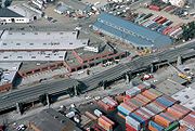
, I-880 passes by Oakland International Airport
, Oakland-Alameda County Coliseum and Downtown Oakland
. The northern terminus of I-880 is in Oakland at the junction with Interstate 80
and Interstate 580
(known as the MacArthur Maze
), near the eastern approach of the Bay Bridge.
I-880 between I-238 in San Leandro and the MacArthur Maze is used as an alternate truck route; trucks over 4.5 tons are prohibited through Oakland on I-580.
Officially, the Nimitz Freeway designation is Route 880 from Route 101 to Route 80, as named by Senate Concurrent Resolution 23, Chapter 84 in 1958.
, and then continued along existing county roads and city streets, now known as Fremont Boulevard, Alvarado Boulevard, Hesperian Boulevard, Lewelling Boulevard, Washington Avenue, 14th Street, 44th Avenue, 12th Street, 14th Avenue, 8th Street, and 7th Street, into downtown Oakland. It then turned north at Cypress Street (now Mandela Parkway), passing through the Bay Bridge Distribution Structure and following a newly constructed alignment (signed as US 40) to El Cerrito.
The first short piece of the new Eastshore Freeway opened to traffic on July 22, 1949, connecting Oak Street downtown with 23rd Avenue. It was extended to 98th Avenue on June 1, 1950, Lewelling Boulevard on June 13, 1952, and Jackson Street (SR 92) on June 5, 1953. At the San Jose end, the overlap with Route 5 between Bayshore Highway (US 101) and Warm Springs was bypassed on July 2, 1954. Within Oakland, the double-decker Cypress Street Viaduct
opened on June 11, 1957, connecting the freeway with the San Francisco – Oakland Bay Bridge. The Oakland segment was extended south to Fremont Boulevard at Beard Road on November 14, 1957, and the gap was filled on November 24, 1958, soon after the state legislature named the highway after Fleet Admiral Chester W. Nimitz. (The short spur to Route 5 at Warm Springs (now SR 262) remained in the state highway system as a branch of Route 69.) As these sections opened, Sign Route 17 (and Legislative Route 69) was moved from its old surface routing, which mostly became local streets. Other than Route 5 south of Warm Springs, the portion from San Leandro into Oakland was also kept as part of Route 105 (now SR 185).
all the way through San Jose
, Oakland
; and then continued north via the Eastshore Freeway (Interstate 80
) through Richmond
to the Richmond-San Rafael Bridge
and San Rafael
.
In 1984 the segment of SR 17 from Interstate 280
in San Jose to the MacArthur Maze
in Oakland was renumbered as I-880, and the portion of SR 17 from the MacArthur Maze
to San Rafael was renumbered as part of I-580.
U.S. Route 50 for a time between the I-80 interchange and downtown Oakland.
area. This freeway begins in West Sacramento as a fork from the original Interstate 80, continues northeast over the Sacramento River
to its interchange with Interstate 5, continues east through the communities of North Sacramento
and Del Paso Heights and ends at an interchange with the Roseville Freeway Interstate 80. Watt Avenue, and the now designated Capital City Freeway
(which was originally I-80 continuing southwest directly into downtown Sacramento).
 A large double-decker section in Oakland, known as the Cypress Street Viaduct
, collapsed during the 1989 Loma Prieta earthquake
, causing 42 deaths. This was the greatest loss of life caused by that earthquake
. Rebuilding the affected section of the freeway took nearly a decade, due to environmental impact concerns, the feeling that the freeway divided the neighborhood, and design
considerations. The freeway reopened in 1997 on a new route parallel to railroad tracks around the outskirts of West Oakland.
Although only about three miles (5 km) in length, the replacement freeway cost over $1.2 billion, for several reasons: it crossed over and under the elevated BART line to San Francisco; it squeezed between a post office, the West Oakland BART station, the Port of Oakland, a rail yard, and a sewage treatment plant; it occupied an entirely new right-of-way, which required the acquisition of large amounts of valuable industrial real estate near the Port of Oakland; and of course, it had to be earthquake-proof.
The former path of the structure, Cypress Street, was renamed Mandela
Parkway, and the median where the freeway stood became a landscaped linear park.
s such as the 1990 interchange improvements at Dixon Landing Road. In that case the Federal Highway Administration was required to make a finding that there was no feasible alternative to the new ramp system as designed. In that same study, the FHWA produced an analysis to support the fact that adequate wetland
s mitigation had been designed into the improvement project.
s. This activity has occurred in Oakland, San Leandro
, Hayward
, Newark
and Fremont
. During the 1989 widening of I-880 in parts of Newark and Fremont, scientific studies were conducted to determine the need for sound walls and to design optimum heights to achieve Federal noise standards
.
interchange. The fire caused major damage to both this connector and one directly above (eastbound I-80 onto eastbound I-580). The overpass was replaced and re-opened 27 days later. The governor, Arnold Schwarzenegger
, declared it as a State of emergency and all public transportation was free on the first commute day.
projects of a major transportation corridor in California, consists of eight separate projects located in a 15-mile segment of the freeway between Oakland and Hayward.
The overall goal of the project is to improve the seismic safety of the corridor. After the 1989 Loma Prieta earthquake, the California Department of Transportation (Caltrans) initiated Phase 1 of its seismic retrofit program. After the 1994 Northridge earthquake, Caltrans initiated Phase 2 of its seismic retrofit program, which included projects along the I-880 corridor. Other goals include reducing traffic congestion and improving road quality.
The individual projects included in the I-880 Corridor Improvement project are the retrofitting or replacement of the 5th Avenue, 23rd Avenue, 23rd Avenue, Fruitvale Avenue, and High Street bridges in Oakland; improvements to both the I-238 and Highway 92 interchanges (the latter, a four year project, completed in October 2011); and an overall rehabilitation/repaving project along the entire segment. Construction will take place from 2006 to 2014, although individual project schedules vary. The total cost of the project is $462.7 million, provided by federal, state, and regional funds.
Interstate Highway System
The Dwight D. Eisenhower National System of Interstate and Defense Highways, , is a network of limited-access roads including freeways, highways, and expressways forming part of the National Highway System of the United States of America...
in the San Francisco Bay Area
San Francisco Bay Area
The San Francisco Bay Area, commonly known as the Bay Area, is a populated region that surrounds the San Francisco and San Pablo estuaries in Northern California. The region encompasses metropolitan areas of San Francisco, Oakland, and San Jose, along with smaller urban and rural areas...
connecting San Jose
San Jose, California
San Jose is the third-largest city in California, the tenth-largest in the U.S., and the county seat of Santa Clara County which is located at the southern end of San Francisco Bay...
and Oakland
Oakland, California
Oakland is a major West Coast port city on San Francisco Bay in the U.S. state of California. It is the eighth-largest city in the state with a 2010 population of 390,724...
, running parallel to the southeastern shore of San Francisco Bay
San Francisco Bay
San Francisco Bay is a shallow, productive estuary through which water draining from approximately forty percent of California, flowing in the Sacramento and San Joaquin rivers from the Sierra Nevada mountains, enters the Pacific Ocean...
. For most of its route, I-880 is officially known as the Nimitz Freeway after World War II
World War II
World War II, or the Second World War , was a global conflict lasting from 1939 to 1945, involving most of the world's nations—including all of the great powers—eventually forming two opposing military alliances: the Allies and the Axis...
fleet admiral Chester Nimitz
Chester Nimitz
Fleet Admiral Chester William Nimitz, GCB, USN was a five-star admiral in the United States Navy. He held the dual command of Commander in Chief, United States Pacific Fleet , for U.S. naval forces and Commander in Chief, Pacific Ocean Areas , for U.S...
, who retired to the Bay Area and lived on Yerba Buena Island
Yerba Buena Island
Yerba Buena Island sits in the San Francisco Bay between San Francisco and Oakland, California. The Yerba Buena Tunnel runs through its center and connects the western and eastern spans of the San Francisco-Oakland Bay Bridge. It has had several other names over the decades: Sea Bird Island, Wood...
.
This route is part of the California Freeway and Expressway System
California Freeway and Expressway System
The California Freeway and Expressway System is a system of existing or planned freeways and expressways in the U.S. state of California. It is defined by the Streets and Highways Code.-List of roads in the system:*State Route 1 *State Route 2...
.
Route description
The southern terminus of I-880 is at its interchange with Interstate 280Interstate 280 (California)
Interstate 280 is a 57-mile long north–south Interstate Highway in the San Francisco Bay Area of Northern California. It connects San Jose and San Francisco, running along just to the west of the cities of San Francisco Peninsula for most of its route.I-280 from its northern end at King...
and State Route 17 in San Jose
San Jose, California
San Jose is the third-largest city in California, the tenth-largest in the U.S., and the county seat of Santa Clara County which is located at the southern end of San Francisco Bay...
. From there, it heads roughly northeast past the San Jose International Airport
San Jose International Airport
Norman Y. Mineta San Jose International Airport is a city-owned public-use airport serving the city of San Jose in Santa Clara County, California, United States. It is named for San Jose native Norman Yoshio Mineta, who was Transportation Secretary in the Cabinet of George W...
to U.S. Route 101. The Nimitz Freeway then turns northwest, running parallel to the southeastern shore of San Francisco Bay
San Francisco Bay
San Francisco Bay is a shallow, productive estuary through which water draining from approximately forty percent of California, flowing in the Sacramento and San Joaquin rivers from the Sierra Nevada mountains, enters the Pacific Ocean...
, connecting the cities of Milpitas
Milpitas, California
Milpitas is a city in Santa Clara County, California. It is a suburb of the major city of San Jose, California. It is located with San Jose to its south and Fremont to its north, at the eastern end of State Route 237 and generally between Interstates 680 and 880 which run roughly north/south...
, Fremont
Fremont, California
Fremont is a city in Alameda County, California. It was incorporated on January 23, 1956, from the merger of five smaller communities: Centerville, Niles, Irvington, Mission San Jose, and Warm Springs...
, Newark
Newark, California
Newark is a city in Alameda County, California, United States. It was incorporated as a city in September 1955. Newark is an enclave, completely surrounded by the city of Fremont. Its population was 42,573 at the 2010 census.-Geography:...
, Union City
Union City, California
Union City is a city in Alameda County, California, United States. It was incorporated in 1959, combining the communities of Alvarado and Decoto. Alvarado was the original county seat of Alameda County, and the site of the first county courthouse is a California Historical Landmark . The city...
, Hayward
Hayward, California
Hayward is a city located in the East Bay in Alameda County, California. With a population of 144,186, Hayward is the sixth largest city in the San Francisco Bay Area and the third largest in Alameda County. Hayward was ranked as the 37th most populous municipality in California. It is included in...
, and San Leandro
San Leandro, California
San Leandro is a city in Alameda County, California, United States. It is considered a suburb of Oakland and San Francisco. The population was 84,950 as of 2010 census. The climate of the city is mild throughout the year.-Geography and water resources:...
before reaching Oakland
Oakland, California
Oakland is a major West Coast port city on San Francisco Bay in the U.S. state of California. It is the eighth-largest city in the state with a 2010 population of 390,724...
. In Oakland
Oakland, California
Oakland is a major West Coast port city on San Francisco Bay in the U.S. state of California. It is the eighth-largest city in the state with a 2010 population of 390,724...
, I-880 passes by Oakland International Airport
Oakland International Airport
Oakland International Airport , also known as Metropolitan Oakland International Airport, is a public airport located south of the central business district of Oakland, a city in Alameda County, California, United States...
, Oakland-Alameda County Coliseum and Downtown Oakland
Downtown Oakland
Downtown Oakland is the central business district of Oakland, California; roughly bounded by 6th Street or the Oakland Estuary on the southwest, Interstate 980 on the northwest, Grand Avenue on the northeast, and Lake Merritt on the east....
. The northern terminus of I-880 is in Oakland at the junction with Interstate 80
Interstate 80 in California
In the U.S. state of California, Interstate 80 , a major east–west route of the Interstate Highway System, has its western terminus in San Francisco, California, United States. From there it heads east across the Bay Bridge to Oakland, where it turns north and crosses the Carquinez Bridge...
and Interstate 580
Interstate 580 (California)
Interstate 580 is an 80-mile east–west Interstate Highway in Northern California. The heavily traveled spur route of Interstate 80 runs from San Rafael in the San Francisco Bay Area to Interstate 5 near Tracy in the Central Valley...
(known as the MacArthur Maze
MacArthur Maze
The MacArthur Maze refers to the large freeway interchange located near the eastern end of the San Francisco – Oakland Bay Bridge in Oakland, California and is the largest freeway interchange in the world...
), near the eastern approach of the Bay Bridge.
I-880 between I-238 in San Leandro and the MacArthur Maze is used as an alternate truck route; trucks over 4.5 tons are prohibited through Oakland on I-580.
Officially, the Nimitz Freeway designation is Route 880 from Route 101 to Route 80, as named by Senate Concurrent Resolution 23, Chapter 84 in 1958.
History
The state legislature added the proposed San Jose-Richmond East Shore Highway to the state highway system in 1933, and it became an extension of the previously short (San Rafael to the bay) Legislative Route 69, and part of Sign Route 13 (soon changed to 17) in 1934. From San Jose, this route temporarily followed existing Legislative Route 5 (present Oakland Road, Main Street, Milpitas Boulevard, and Warm Springs Boulevard) to SR 21 at Warm SpringsWarm Springs, California
Warm Springs is a census-designated place in Riverside County, California. Warm Springs sits at an elevation of . The 2010 United States census reported Warm Springs's population was 2,676.-Geography:...
, and then continued along existing county roads and city streets, now known as Fremont Boulevard, Alvarado Boulevard, Hesperian Boulevard, Lewelling Boulevard, Washington Avenue, 14th Street, 44th Avenue, 12th Street, 14th Avenue, 8th Street, and 7th Street, into downtown Oakland. It then turned north at Cypress Street (now Mandela Parkway), passing through the Bay Bridge Distribution Structure and following a newly constructed alignment (signed as US 40) to El Cerrito.
The first short piece of the new Eastshore Freeway opened to traffic on July 22, 1949, connecting Oak Street downtown with 23rd Avenue. It was extended to 98th Avenue on June 1, 1950, Lewelling Boulevard on June 13, 1952, and Jackson Street (SR 92) on June 5, 1953. At the San Jose end, the overlap with Route 5 between Bayshore Highway (US 101) and Warm Springs was bypassed on July 2, 1954. Within Oakland, the double-decker Cypress Street Viaduct
Cypress Street Viaduct
The Cypress Street Viaduct, often referred to as the Cypress Structure, was a 1.6 mile long, raised two-tier, multi-lane freeway constructed of reinforced concrete that was originally part of the Nimitz Freeway in Oakland, California.It replaced an earlier single-deck viaduct constructed in the...
opened on June 11, 1957, connecting the freeway with the San Francisco – Oakland Bay Bridge. The Oakland segment was extended south to Fremont Boulevard at Beard Road on November 14, 1957, and the gap was filled on November 24, 1958, soon after the state legislature named the highway after Fleet Admiral Chester W. Nimitz. (The short spur to Route 5 at Warm Springs (now SR 262) remained in the state highway system as a branch of Route 69.) As these sections opened, Sign Route 17 (and Legislative Route 69) was moved from its old surface routing, which mostly became local streets. Other than Route 5 south of Warm Springs, the portion from San Leandro into Oakland was also kept as part of Route 105 (now SR 185).
State Route 17
Prior to 1984, the route known as I-880 used to be part of State Route 17. SR 17 used to run from Santa CruzSanta Cruz, California
Santa Cruz is the county seat and largest city of Santa Cruz County, California in the US. As of the 2010 U.S. Census, Santa Cruz had a total population of 59,946...
all the way through San Jose
San Jose, California
San Jose is the third-largest city in California, the tenth-largest in the U.S., and the county seat of Santa Clara County which is located at the southern end of San Francisco Bay...
, Oakland
Oakland, California
Oakland is a major West Coast port city on San Francisco Bay in the U.S. state of California. It is the eighth-largest city in the state with a 2010 population of 390,724...
; and then continued north via the Eastshore Freeway (Interstate 80
Interstate 80 in California
In the U.S. state of California, Interstate 80 , a major east–west route of the Interstate Highway System, has its western terminus in San Francisco, California, United States. From there it heads east across the Bay Bridge to Oakland, where it turns north and crosses the Carquinez Bridge...
) through Richmond
Richmond, California
Richmond is a city in western Contra Costa County, California, United States. The city was incorporated on August 7, 1905. It is located in the East Bay, part of the San Francisco Bay Area. It is a residential inner suburb of San Francisco, as well as the site of heavy industry, which has been...
to the Richmond-San Rafael Bridge
Richmond-San Rafael Bridge
The Richmond – San Rafael Bridge is the northernmost of the east–west crossings of the San Francisco Bay in California, USA, connecting Richmond on the east to San Rafael on the west end...
and San Rafael
San Rafael, California
San Rafael is a city and the county seat of Marin County, California, United States. The city is located in the North Bay region of the San Francisco Bay Area...
.
In 1984 the segment of SR 17 from Interstate 280
Interstate 280 (California)
Interstate 280 is a 57-mile long north–south Interstate Highway in the San Francisco Bay Area of Northern California. It connects San Jose and San Francisco, running along just to the west of the cities of San Francisco Peninsula for most of its route.I-280 from its northern end at King...
in San Jose to the MacArthur Maze
MacArthur Maze
The MacArthur Maze refers to the large freeway interchange located near the eastern end of the San Francisco – Oakland Bay Bridge in Oakland, California and is the largest freeway interchange in the world...
in Oakland was renumbered as I-880, and the portion of SR 17 from the MacArthur Maze
MacArthur Maze
The MacArthur Maze refers to the large freeway interchange located near the eastern end of the San Francisco – Oakland Bay Bridge in Oakland, California and is the largest freeway interchange in the world...
to San Rafael was renumbered as part of I-580.
Nimitz Freeway
In 1947, construction commenced on a freeway to replace the street routing of SR 17 through the East Bay. The new freeway was named the "Eastshore Freeway", and with the subsequent addition of a freeway to replace the Eastshore Highway north of the MacArthur Maze in the mid 1950s, it ran, appropriately, almost the entire length of the east shore of San Francisco Bay. In 1958, the portion south of the MacArthur Maze was re-named the Nimitz Freeway in honor of WWII Admiral Nimitz, while the portion to the north retained the name Eastshore Freeway.Historic Business U.S. Route 50
The northern portion of I-880 was designated BusinessBusiness route
A business route in the United States and Canada is a short special route connected to a parent numbered highway at its beginning, then routed through the central business district of a nearby city or town, and finally reconnecting with the same parent numbered highway again at its...
U.S. Route 50 for a time between the I-80 interchange and downtown Oakland.
Original routing of I-880 in Sacramento
From 1971 to 1983, Interstate 880 was also the route designation for the Beltline Freeway, the northern bypass freeway for the SacramentoSacramento
Sacramento is the capital of the state of California, in the United States of America.Sacramento may also refer to:- United States :*Sacramento County, California*Sacramento, Kentucky*Sacramento – San Joaquin River Delta...
area. This freeway begins in West Sacramento as a fork from the original Interstate 80, continues northeast over the Sacramento River
Sacramento River
The Sacramento River is an important watercourse of Northern and Central California in the United States. The largest river in California, it rises on the eastern slopes of the Klamath Mountains, and after a journey south of over , empties into Suisun Bay, an arm of the San Francisco Bay, and...
to its interchange with Interstate 5, continues east through the communities of North Sacramento
North Sacramento
North Sacramento is a well-established community that is currently part of the city of Sacramento, California. It was a city from its incorporation in 1924 until it was merged in 1964 into the City of Sacramento....
and Del Paso Heights and ends at an interchange with the Roseville Freeway Interstate 80. Watt Avenue, and the now designated Capital City Freeway
Interstate 80 Business (Sacramento, California)
Interstate 80 Business, called the Capital City Freeway in its entirety, is a Business Loop of Interstate 80 through Sacramento. As it is state-maintained, unlike most business routes in California, it is assigned route numbers - part of U.S. Route 50 on its western half , and unsigned State Route...
(which was originally I-80 continuing southwest directly into downtown Sacramento).
Cypress Viaduct Loma Prieta earthquake 1989
Cypress Street Viaduct
The Cypress Street Viaduct, often referred to as the Cypress Structure, was a 1.6 mile long, raised two-tier, multi-lane freeway constructed of reinforced concrete that was originally part of the Nimitz Freeway in Oakland, California.It replaced an earlier single-deck viaduct constructed in the...
, collapsed during the 1989 Loma Prieta earthquake
Loma Prieta earthquake
The Loma Prieta earthquake, also known as the Quake of '89 and the World Series Earthquake, was a major earthquake that struck the San Francisco Bay Area of California on October 17, 1989, at 5:04 p.m. local time...
, causing 42 deaths. This was the greatest loss of life caused by that earthquake
Earthquake
An earthquake is the result of a sudden release of energy in the Earth's crust that creates seismic waves. The seismicity, seismism or seismic activity of an area refers to the frequency, type and size of earthquakes experienced over a period of time...
. Rebuilding the affected section of the freeway took nearly a decade, due to environmental impact concerns, the feeling that the freeway divided the neighborhood, and design
Design
Design as a noun informally refers to a plan or convention for the construction of an object or a system while “to design” refers to making this plan...
considerations. The freeway reopened in 1997 on a new route parallel to railroad tracks around the outskirts of West Oakland.
Although only about three miles (5 km) in length, the replacement freeway cost over $1.2 billion, for several reasons: it crossed over and under the elevated BART line to San Francisco; it squeezed between a post office, the West Oakland BART station, the Port of Oakland, a rail yard, and a sewage treatment plant; it occupied an entirely new right-of-way, which required the acquisition of large amounts of valuable industrial real estate near the Port of Oakland; and of course, it had to be earthquake-proof.
The former path of the structure, Cypress Street, was renamed Mandela
Nelson Mandela
Nelson Rolihlahla Mandela served as President of South Africa from 1994 to 1999, and was the first South African president to be elected in a fully representative democratic election. Before his presidency, Mandela was an anti-apartheid activist, and the leader of Umkhonto we Sizwe, the armed wing...
Parkway, and the median where the freeway stood became a landscaped linear park.
Flood plains
Several aspects of the I-880 facility have been constructed in designated floodplainFloodplain
A floodplain, or flood plain, is a flat or nearly flat land adjacent a stream or river that stretches from the banks of its channel to the base of the enclosing valley walls and experiences flooding during periods of high discharge...
s such as the 1990 interchange improvements at Dixon Landing Road. In that case the Federal Highway Administration was required to make a finding that there was no feasible alternative to the new ramp system as designed. In that same study, the FHWA produced an analysis to support the fact that adequate wetland
Wetland
A wetland is an area of land whose soil is saturated with water either permanently or seasonally. Wetlands are categorised by their characteristic vegetation, which is adapted to these unique soil conditions....
s mitigation had been designed into the improvement project.
Sound barriers
Due to high sound levels generated from this highway and the relatively dense urban development in the highway corridor, Caltrans has conducted numerous studies to retrofit the right-of-way with noise barrierNoise barrier
A noise barrier is an exterior structure designed to protect sensitive land uses from noise pollution...
s. This activity has occurred in Oakland, San Leandro
San Leandro, California
San Leandro is a city in Alameda County, California, United States. It is considered a suburb of Oakland and San Francisco. The population was 84,950 as of 2010 census. The climate of the city is mild throughout the year.-Geography and water resources:...
, Hayward
Hayward, California
Hayward is a city located in the East Bay in Alameda County, California. With a population of 144,186, Hayward is the sixth largest city in the San Francisco Bay Area and the third largest in Alameda County. Hayward was ranked as the 37th most populous municipality in California. It is included in...
, Newark
Newark, California
Newark is a city in Alameda County, California, United States. It was incorporated as a city in September 1955. Newark is an enclave, completely surrounded by the city of Fremont. Its population was 42,573 at the 2010 census.-Geography:...
and Fremont
Fremont, California
Fremont is a city in Alameda County, California. It was incorporated on January 23, 1956, from the merger of five smaller communities: Centerville, Niles, Irvington, Mission San Jose, and Warm Springs...
. During the 1989 widening of I-880 in parts of Newark and Fremont, scientific studies were conducted to determine the need for sound walls and to design optimum heights to achieve Federal noise standards
Noise regulation
Noise regulation includes statutes or guidelines relating to sound transmission established by national, state or provincial and municipal levels of government. After the watershed passage of the United States Noise Control Act of 1972, other local and state governments passed further regulations...
.
Gasoline tanker accident in 2007
On April 29, 2007, a gasoline tanker overturned and caught fire on the connector between westbound I-80 and southbound I-880 on the MacArthur MazeMacArthur Maze
The MacArthur Maze refers to the large freeway interchange located near the eastern end of the San Francisco – Oakland Bay Bridge in Oakland, California and is the largest freeway interchange in the world...
interchange. The fire caused major damage to both this connector and one directly above (eastbound I-80 onto eastbound I-580). The overpass was replaced and re-opened 27 days later. The governor, Arnold Schwarzenegger
Arnold Schwarzenegger
Arnold Alois Schwarzenegger is an Austrian-American former professional bodybuilder, actor, businessman, investor, and politician. Schwarzenegger served as the 38th Governor of California from 2003 until 2011....
, declared it as a State of emergency and all public transportation was free on the first commute day.
2010 I-880/I-280 Interchange improvement
In 2010 improvements to the I-280/I-880 and Stevens Creek Boulevard interchanges were made. Previously, both interchanges shared a handful of ramps, but they are now independent from one another.Future
The I-880 Corridor Improvement Project, one of the last seismic retrofitSeismic retrofit
Seismic retrofitting is the modification of existing structures to make them more resistant to seismic activity, ground motion, or soil failure due to earthquakes. With better understanding of seismic demand on structures and with our recent experiences with large earthquakes near urban centers,...
projects of a major transportation corridor in California, consists of eight separate projects located in a 15-mile segment of the freeway between Oakland and Hayward.
The overall goal of the project is to improve the seismic safety of the corridor. After the 1989 Loma Prieta earthquake, the California Department of Transportation (Caltrans) initiated Phase 1 of its seismic retrofit program. After the 1994 Northridge earthquake, Caltrans initiated Phase 2 of its seismic retrofit program, which included projects along the I-880 corridor. Other goals include reducing traffic congestion and improving road quality.
The individual projects included in the I-880 Corridor Improvement project are the retrofitting or replacement of the 5th Avenue, 23rd Avenue, 23rd Avenue, Fruitvale Avenue, and High Street bridges in Oakland; improvements to both the I-238 and Highway 92 interchanges (the latter, a four year project, completed in October 2011); and an overall rehabilitation/repaving project along the entire segment. Construction will take place from 2006 to 2014, although individual project schedules vary. The total cost of the project is $462.7 million, provided by federal, state, and regional funds.
Exit list
External links
- AA Roads - I-880 Guide
- The October 17, 1989, Loma Prieta, California, Earthquake—Selected Photographs - U.S. Geological Survey
- Cypress Street Viaduct includes map of old MacArthur MazeMacArthur MazeThe MacArthur Maze refers to the large freeway interchange located near the eastern end of the San Francisco – Oakland Bay Bridge in Oakland, California and is the largest freeway interchange in the world...
with old U.S. Route 40/U.S. Route 50 designations - Cypress Viaduct Reconstruction from Federal Highway Administration