
Shasta Dam
Encyclopedia
Shasta Dam is an arch dam
across the Sacramento River
in the northern part of the U.S. state
of California
, at the north end of the Sacramento Valley
. The dam mainly serves long-term water storage and flood control in its reservoir, Shasta Lake
, and also generates hydroelectric power. At 602 feet (183.5 m) high, it is the ninth-tallest dam in the United States and forms the largest reservoir in California.
Envisioned as early as 1919 because of frequent floods and droughts troubling California's largest agricultural region, the Central Valley, the dam was first authorized in the 1930s as a state undertaking. However, this coincided with the Great Depression
and building of the dam was transferred to the federal Bureau of Reclamation as a public works project. Construction started in earnest in 1937 under the supervision of Chief Engineer Frank Crowe
. During its building, the dam provided thousands of much-needed jobs; it was finished twenty-six months ahead of schedule in 1945. When completed, the dam was the second-tallest in the United States after Hoover
, and was considered one of the greatest engineering feats of all time.
Even before its dedication, Shasta Dam served an important role in World War II
providing electricity to California factories, and still plays a vital part in the management of state water resources today. However, it has brought about major changes to the environment and ecology of the Sacramento River, and met with controversy over its significant destruction of Native American tribal lands. In recent years, there has been debate over whether or not to raise the dam in order to allow for increased water storage and hydropower generation.
 In the 19th century, the Central Valley was the main destination for vast numbers of immigrants traveling into California from the eastern United States
. The valley's land was coveted for its fertile soils, mild climate, rolling topography, and perhaps most importantly, the abundance of water. The state's largest river by discharge, the Sacramento River
, flows through the northern third of the valley, known as the Sacramento Valley
. The river flows south for a distance of 445 miles (716.2 km) before emptying into a vast estuary
, the Sacramento-San Joaquin Delta, which outlets into Suisun Bay
, the Carquinez Strait
, San Francisco Bay
and finally the Pacific Ocean
. By the late 1800s, both the valley and Delta regions were intensely cultivated with various crops including wheat, cotton, rice, citrus and melons.
The region's agricultural focus makes it especially vulnerable to droughts, and the low topography causes flooding dangers. Although the Sacramento River has a copious flow of nearly 31000 cuft/s, most of the discharge occurs during the winter and early spring with storms and snowmelt, and can diminish to a trickle during the late summers and autumns of drought years. With increased irrigation in the valley, low flows dropped even lower, causing the outflow of the river to be unable to match the pace of high tides coming in from San Francisco Bay. Resultantly the salinity of the water in the Delta region started to rise, causing problems for farms on the Delta's many islands and allowed teredo
, a saltwater worm, to thrive destroying piers and ships in Suisun Bay during a drought from 1919 to 1924.
In desperation to solve the salinity problem, area residents first proposed constructing a tidal barrage
across the mouth of Suisun Bay, but the Marshall Plan, put forwards in 1919 by Robert Marshall of the United States Geological Survey
, had a different solution. The plan's main component was the building of a large dam across the Sacramento just downstream of its confluence with the Pit River
near the copper mining town of Kennett, several hundred miles above the Sacramento's mouth. Instead of blocking saltwater intrusion into the Delta directly, this dam would store winter floodwaters for use during the dry months, providing a stable, regulated flow with the added benefit of helping irrigation and providing flood control in the Sacramento Valley.
in 1921, it passed in the Senate
but failed in the House of Representatives
. However, the problems of the Californians did not go unheard afterwards – in 1931, State Engineer Edward Hyatt suggested a similar but slightly less pricey proposal called the State Water Plan, with a projected cost of about $550 million. Including the dam at Kennett and an aqueduct from the Delta southwards into the arid San Joaquin Valley
and coastal Southern California
, Hyatt's scheme laid the foundations for both the present day Central Valley Project
(CVP) and the California State Water Project
(SWP).
The State Water Plan's cost was originally to fall on the shoulders of California taxpayers, who were the ones who needed the water. Unfortunately, this coincided with the Great Depression
of the 1930s and the state was unable to raise the money needed to construct the dams and canals needed for the project. Soon the unemployment rate in California hovered around 20%, and a severe drought hit the West Coast. Now with its potential to provide jobs and control the much-needed water, Central and Northern Californians were desperate to get the CVP approved by the legislature. The project ended up getting approved by a slim margin – Southern Californians generally opposed the project because they had already secured water rights from the Colorado River
, not the Sacramento, and wanted to strengthen those rights. In 1933, California's legislature authorized the selling of revenue bond
s to fund the CVP, whose main component was to be Shasta Dam.
Unable to acquire funds, California's government turned to Washington D.C. for assistance, hoping that the federal government would provide financial assistance or purchase the bonds. Eventually, California ended up pleading for the government to take over the project. President Franklin Delano Roosevelt approved, as the construction works at Shasta Dam and other portions of the project would provide thousands of much-needed jobs. Roosevelt first considered the U.S. Army Corps of Engineers to build the project, but instead transferred it to the Bureau of Reclamation (back then the Reclamation Service) which had expertise building large dams as demonstrated at the Hoover Dam
(Boulder Canyon Project) several years earlier. Reclamation chose Frank Crowe
, the superintendent of the Hoover Dam, to direct operations at the Shasta Dam.
Construction started with the excavation of millions of tons of bedrock from the canyon walls adjacent to the construction site to provide keyways to lay the dam's foundations. The Shasta Route of the Southern Pacific Railroad
, which ran through the site, was rerouted to the east over the steel truss Pit River Bridge
, then the tallest double-deck bridge ever built. The bridge was built to a height of more than 500 feet (152.4 m) above the Pit River, some 7 miles (11.3 km) east-northeast of the damsite, to accommodate the rising waters of Shasta Lake. The remaining portion of the railroad from Redding to the Shasta site was used as a branch line for construction trains traveling to and from the site, and routed through a tunnel beneath the south abutment of the dam.
Pacific Constructors, the main company building Shasta Dam, set up its own camp near the base of the Shasta Dam site, called "Contractor's Camp" or "Shasta Dam Village". The company built an enormous 2,000-man mess hall, hospital, recreational center and other venues at the damsite. Three other makeshift camps nearby, called "Central Valley", "Project City" and "Summit City", soon filled with men from all over the state hoping to get jobs at the Shasta Dam – as drillers, crane operators, mechanics, truck drivers, carpenters, welders, among others.
built to dry up the bypassed section. To supply sand and gravel to make concrete at the construction site, Pacific Constructors built the largest conveyor belt
system in the world, a 9.5 miles (15.3 km) monster reaching from Redding all the way to the damsite. This was capable of transporting 1,100 tons of material per hour, and over the entire construction process, hauled more than 12 million tons of rock. The belt, which had some 16,000 rollers, was divided into twenty-six sections, 23 of which were powered by individual 200-hp motors. The remaining three were downhill and did not require power; in fact they were retrofitted to generate power for some of the other sections.
As the foundations were completed, concrete placement of the main dam body could begin. For this purpose, a system of steel cable towers was erected to carry the steel concrete pouring buckets. The tower setup comprised one main tower, standing 465 feet (141.7 m) high from its foundations and 700 feet (213.4 m) above the river, and seven movable auxiliary towers; cables were strung between the top of the main tower to each of the others. Using this system, construction crews were able to transport concrete from the mixing plant, which lay directly adjacent to the main tower at the end of the conveyor belt, to the rising structure of the dam faster and cheaper than any other method.
In December 1941, the Japanese attacked Pearl Harbor, prompting the United States to join into World War II
. With thousands of men enlisting in the armed forces, the Shasta Dam site soon had a severe labor shortage. During the war years, many of the people who worked at the dam were women and high school students on mostly "non-hazardous jobs". The dam played an important part in World War II even before its completion, supplying much-needed electricity to shipyards and aircraft factories in central California. However, some generators originally intended for Shasta ended up in the Grand Coulee Dam
in northern Washington because of the enormous demand of electricity from that dam to power aluminum smelters in the Northwest. The strained supplies and labor forced Reclamation to cut the final height of the dam from 800 feet (243.8 m) to 602 feet (183.5 m).
With the tunnel cleared, it was resurfaced and modified to accommodate the force of a river instead of a railroad. This was because up till this point, the Sacramento had still been flowing through the middle of the dam site, between the two nearly-completed abutments of the dam. An earth/rock filled cofferdam was constructed across the river, which now began to flow through the tunnel, drying out the dam site and enabling work to begin on the middle section of the dam, which contained the spillway bays. The spillways with their 18 high-pressure river outlet valves and massive triple drum gates were completed in the summer of 1943. By then, a total of 15 million tons of concrete had been used in the dam's construction, comprising the 16,900 50-foot blocks.
Water storage at the Shasta Dam began in February 1944 when the diversion tunnel was sealed. As the lake rose behind it, the dam was completed to its final shape and the last bucket of concrete was poured on January 2, 1945. During this time, the Shasta Dam powerplant, with a capacity of 379 MW, was also under construction. Five steel penstocks, each 15 feet (4.6 m) in diameter, were installed to provide water to drive the turbines in the power station. The powerhouse was a reinforced concrete structure standing 153 feet (46.6 m) above the river; electricity was first generated there in 1944. The dam was completed at the dawn of 1945.
in the Pacific Northwest
. So said an anonymous workman, "Old Shasta's about the secondest dam there is." When the dam was completed, chief engineer Frank Crowe is known to have said, "Look at that Shasta Dam. That dam will stand there forever holding back the river. And that powerhouse will keep right on turning out juice until somebody discovers how to make power out of sunlight." (Ironically, the invention of photovoltaics
in the 1950s disproved Crowe's claim, although the Shasta Dam continues to produce as much electricity as ever.)
. The dam's other major purpose is to generate hydroelectricity. With a hydraulic head of 330 feet (100.6 m), the dam is capable of generating 676 MW from five turbines – a pair of 125-MW units and three 142-MW units. Each of the turbines is driven by a high-pressure jet of water fed by a steel penstock 15 feet (4.6 m) in diameter. Two smaller turbines generate power for operations at the dam itself. The plant serves to generate peaking power for the northern Sacramento Valley. Shasta operates in tandem with Keswick Dam
, about 9 miles (14.5 km) downstream, which serves as an afterbay for Shasta, regulating its fluctuating water releases.
A thick gravity-arch structure, the dam stands 602 feet (183.5 m) above the foundations with a maximum height of 522.5 feet (159.3 m) above the river. It is 3460 feet (1,054.6 m) long, with a maximum thickness of 543 feet (165.5 m); altogether the dam contains 6270000 cubic yards (4,793,759 m³) of material. The dam is protected against floods by a system of eighteen outlet valves on the face of the spillway. These valves are arranged in three levels, each cutting through the main dam structure and discharging onto the face of the spillway. The upper level has six outlets, each with a capacity of slightly less than 6534 cuft/s. The middle layer has eight conduits capable of carrying 3100 cuft/s and the lowest has four exits each able to discharge 4450 cuft/s for a total of 81800 cuft/s. The spillway is a massive concrete chute, 487 feet (148.4 m) long and 375 feet (114.3 m) wide, controlled by three 110 feet (33.5 m)-wide drum gates each weighing 500 tons. When the reservoir is full, the gates cannot entirely prevent leakage but can raise the water level up to 28 feet (8.5 m) above the spillway crest. The spillway has a capacity of 186000 cuft/s, bringing the dam's maximum overflow rate to 267800 cuft/s.
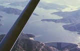
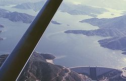
The dam forms a reservoir called Shasta Lake
, which with its capacity of 4552000 acre.ft and surface of 30310 acres (12,266 ha) at maximum pool, is the largest man-made lake and third largest body of water in California. The lake extends for 15.3 miles (24.6 km) up the Sacramento River and branches for more than 21 miles (33.8 km) up the Pit River, which is actually the larger river flowing into the lake. Shasta Lake also has bays of the McCloud River
, Squaw Creek, Salt Creek, and scores of other smaller streams that feed it. The Shasta Dam controls runoff from a drainage basin of 6665 square miles (17,262.3 km²), or about a quarter of the 27580 square miles (71,431.9 km²) Sacramento River watershed.
 In the 1990s, with skyrocketing water shortages in the Central Valley and some of California's largest agricultural coalitions including the Westlands Irrigation District calling for a more dependable water supply, the Bureau of Reclamation suggested the expansion of Shasta Dam. The expansion is considered feasible because the dam's foundations were originally built to carry the weight of a 800 feet (243.8 m) structure, but resources shortages at the onset of World War II prevented completing it to its final height.
Reclamation has suggested three options for the dam raise, ranging from less than 20 feet (6.1 m) to more than 200 feet (61 m). The "low option", which simply comprises adding a vertical concrete dike to the top of the dam, would provide maximum additional storage while minimizing requirements for reconstruction of buildings and facilities around Shasta Lake. The "intermediate option" would require adding more than 100 feet (30.5 m) to the crest and replacing the elevator towers on the front of the dam, and the Pit River Bridge
and small towns around the lake, if not modified or moved, would be inundated. Finally, the "high option" would raise the dam over 200 feet (61 m), tripling the volume and doubling the surface area of the reservoir. Both the intermediate and high options would require saddle dams constructed at key points along the lake to keep it from overflowing.
The intermediate and high dam raises would allow for increased generation of hydropower. Each would require the construction of a new powerhouse to accommodate five new turbines; for the intermediate expansion, five 215-MW generators would be added for a total capacity of 1,751 MW, while for the high one, there would be five new 260-MW units for a maximum capacity of 1,976 MW. Downstream Keswick Dam would also be raised and its power station retrofitted to accommodate the greater peaking releases from Shasta.
Raising specifications for Shasta Dam
The proposed dam raise has met with significant backlash from area inhabitants, fishermen, Native Americans, recreationalists and environmentalists. First of all, with any increase to the dam's height, significant reaches of the Pit, Sacramento, and McCloud Rivers would be inundated. The McCloud is an area of special interest because it is one of California's best trout fisheries and because many sacred Native American sites lie along its banks. Opponents of dam raise contend that it would cost more (starting with replacing over 600 structures that would be inundated under the lake including the Pit River Bridge) than its benefits. The water supplied from such a raise would be costly and could be saved if Central Valley farmers cut their water use by only a fraction. It would result in more problems for the ecology of the lower Sacramento, not least its dying salmon
runs.
One of the most important points made by dam expansion opponents is that raising the dam will not create more water (in fact it will actually cause some water loss due to evaporation) but merely increases the capacity to store it. As a result, the reservoir will rarely be filled, as no matter how much Reclamation expands the dam, the river's flow will not increase. The cost of the dam raise is projected at $500 million-$1 billion. One of the expansion's most stoic opponents is the Winnemem Wintu
tribe, almost all of whose land was inundated by the construction of Shasta Dam. Raising the dam would destroy much of their little remaining land.
Some progress has been made towards the dam expansion including for the completion of a costly EIR (Environment Impact Report) by the Bureau of Reclamation – and the purchase of over 3000 acres (1,214.1 ha) of land along the McCloud River by Westlands Irrigation District to help the Bureau gain rights to expand the dam; Westlands believes that the added storage of the dam would greatly benefit its farmers. As of 2007, the irrigation district has spent $35 million. However, Westlands has had a spotty record with environmental responsibility and has been criticized by environmentalists for high levels of pesticide and selenium
in the toxic runoff waters from farms operating under the district.
in the Sacramento River watershed ever since its gates were first closed in 1943. The massive structure completely prevents salmon migration from the lower reaches of the river to the Upper Sacramento, Pit, McCloud and other tributary streams. It is estimated that half of the best salmon habitat in the Sacramento basin lies upstream of Shasta Dam. Also, the dam caused temperatures in the river to rise because it released waters from higher elevations of Shasta Lake, which are warmed by the sun far more than the surface of the original river pre-dam. Warm waters are harmful to salmon, which prefer colder temperatures, and also impact other fish populations such as steelhead and wild California trout
.
In an attempt to save the plunging salmon populations, the federal government constructed the Coleman National Fish Hatchery
on Battle Creek
in 1942. The hatchery is situated approximately 20 miles (32.2 km) southeast of Redding, and produces 13,850,000 eggs per year – nearly 87 percent of which are for the fall chinook salmon
run. Another remedy was carried out by the Bureau of Reclamation in 1991, with the installation of a gigantic facility called a TCD (Temperature Control Device) on the rear face of Shasta Dam. This structure enables dam operators to decide the depth of the reservoir from which the water feeding into the penstocks originates. As one progresses deeper into Shasta Lake, the water gets colder where it receives less sunlight. The TCD is equipped with fifteen openings called "shutters" arranged in rows along the back face of the structure. The rows lie 1022 feet (311.5 m), 922 feet (281 m), and 817 feet (249 m) above sea level. (The crest of Shasta Dam is at an elevation of 1077 feet (328.3 m).) The system has shown significant success in reducing the temperature of the Sacramento River below the dam, although it does exhibit leakage.
As for the health of the river overall, the dam has of course indirectly affected it by promoting the growth of cities and farms along it. However, construction of the dam also has had direct consequences to the morphology and vegetation zones along the river. By raising summer flows much higher than their natural average, and moderating the effects of most floods, the post-dam river supplies an even amount of water to the riparian zone
each year, and resultantly vegetation has encroached on the river channel. The dam has vastly reduced the amount of sediment in the Sacramento, and the riverbanks now suffer decreased erosion, slowing the growth of meander
s and side-channels. Additionally, nearly all the rock and sand used in the mixing of concrete for the dam was dredged from the river downstream of the dam, further depleting its sediment supply.
, one of nine groups of the larger Wintu
ethnicity of northern California. It is estimated that the pre-colonization population of the valley was roughly 14,000; by 1900, due to diseases and settlers' encroachment it was reduced to 395. Of the men who survived out of the 395, many patriotically fought in the U.S. armed forces during World War II. Ironically and tragically, when they returned in 1945, they found their family members driven out of their traditional villages by the rising waters of Shasta Lake. More than 90 percent of their original land was lost, and the ten percent that remains now lies along the lower McCloud River.
Scores of village sites, burial sites and other sacred locations now sit several hundred feet below the surface of Shasta Lake. Tribal members argue that several reservation treaties originally set by the U.S. government in the 1850s were later broken so the filling of Shasta Lake could proceed; afterwards, only a tiny fraction of that land remained theirs. Furthermore, the Winnemem are not recognized by the federal government, an omission that they have been seeking to rectify for over a century. Recently, native hostility to the dam has heightened because of the proposals to raise it – which would drown twenty of the remaining sacred sites, including Children's Rock and Puberty Rock, both used in coming-of-age ceremonies, and a burial place for victims of the Kaibai Creek Massacre. The tribe conducted a war dance in September 2004 for the first time in 117 years in opposition of the dam and Reclamation's raising project; the event reputedly inspired many environmental groups to support the tribe's position.
. Many public and private marinas, campgrounds, RV parks, resorts and boat launches border the reservoir, one of the most popular recreational lakes in California. Houseboating, water-skiing, swimming and fishing are among the numerous activities available at the lake; hiking, picnicking, mountain biking, hunting and camping are popular in the mountainous vicinity surrounding it.
Arch dam
An arch dam is a type of dam that is curved and commonly built with concrete. The arch dam is a structure that is designed to curve upstream so that the force of the water against it, known as hydrostatic pressure, presses against the arch, compressing and strengthening the structure as it pushes...
across the Sacramento River
Sacramento River
The Sacramento River is an important watercourse of Northern and Central California in the United States. The largest river in California, it rises on the eastern slopes of the Klamath Mountains, and after a journey south of over , empties into Suisun Bay, an arm of the San Francisco Bay, and...
in the northern part of the U.S. state
U.S. state
A U.S. state is any one of the 50 federated states of the United States of America that share sovereignty with the federal government. Because of this shared sovereignty, an American is a citizen both of the federal entity and of his or her state of domicile. Four states use the official title of...
of California
California
California is a state located on the West Coast of the United States. It is by far the most populous U.S. state, and the third-largest by land area...
, at the north end of the Sacramento Valley
Sacramento Valley
The Sacramento Valley is the portion of the California Central Valley that lies to the north of the San Joaquin-Sacramento Delta in the U.S. state of California. It encompasses all or parts of ten counties.-Geography:...
. The dam mainly serves long-term water storage and flood control in its reservoir, Shasta Lake
Shasta Lake
Shasta Lake, also called Lake Shasta, is an artificial lake created by the construction of Shasta Dam across the Sacramento River in the Shasta-Trinity National Forest of Shasta County, California...
, and also generates hydroelectric power. At 602 feet (183.5 m) high, it is the ninth-tallest dam in the United States and forms the largest reservoir in California.
Envisioned as early as 1919 because of frequent floods and droughts troubling California's largest agricultural region, the Central Valley, the dam was first authorized in the 1930s as a state undertaking. However, this coincided with the Great Depression
Great Depression
The Great Depression was a severe worldwide economic depression in the decade preceding World War II. The timing of the Great Depression varied across nations, but in most countries it started in about 1929 and lasted until the late 1930s or early 1940s...
and building of the dam was transferred to the federal Bureau of Reclamation as a public works project. Construction started in earnest in 1937 under the supervision of Chief Engineer Frank Crowe
Frank Crowe
Francis Trenholm Crowe was the chief engineer of the Hoover Dam. During that time, he was the superintendent of Six Companies, the construction company that oversaw the construction project....
. During its building, the dam provided thousands of much-needed jobs; it was finished twenty-six months ahead of schedule in 1945. When completed, the dam was the second-tallest in the United States after Hoover
Hoover Dam
Hoover Dam, once known as Boulder Dam, is a concrete arch-gravity dam in the Black Canyon of the Colorado River, on the border between the US states of Arizona and Nevada. It was constructed between 1931 and 1936 during the Great Depression and was dedicated on September 30, 1935, by President...
, and was considered one of the greatest engineering feats of all time.
Even before its dedication, Shasta Dam served an important role in World War II
World War II
World War II, or the Second World War , was a global conflict lasting from 1939 to 1945, involving most of the world's nations—including all of the great powers—eventually forming two opposing military alliances: the Allies and the Axis...
providing electricity to California factories, and still plays a vital part in the management of state water resources today. However, it has brought about major changes to the environment and ecology of the Sacramento River, and met with controversy over its significant destruction of Native American tribal lands. In recent years, there has been debate over whether or not to raise the dam in order to allow for increased water storage and hydropower generation.
Early proposals
Eastern United States
The Eastern United States, the American East, or simply the East is traditionally defined as the states east of the Mississippi River. The first two tiers of states west of the Mississippi have traditionally been considered part of the West, but can be included in the East today; usually in...
. The valley's land was coveted for its fertile soils, mild climate, rolling topography, and perhaps most importantly, the abundance of water. The state's largest river by discharge, the Sacramento River
Sacramento River
The Sacramento River is an important watercourse of Northern and Central California in the United States. The largest river in California, it rises on the eastern slopes of the Klamath Mountains, and after a journey south of over , empties into Suisun Bay, an arm of the San Francisco Bay, and...
, flows through the northern third of the valley, known as the Sacramento Valley
Sacramento Valley
The Sacramento Valley is the portion of the California Central Valley that lies to the north of the San Joaquin-Sacramento Delta in the U.S. state of California. It encompasses all or parts of ten counties.-Geography:...
. The river flows south for a distance of 445 miles (716.2 km) before emptying into a vast estuary
Estuary
An estuary is a partly enclosed coastal body of water with one or more rivers or streams flowing into it, and with a free connection to the open sea....
, the Sacramento-San Joaquin Delta, which outlets into Suisun Bay
Suisun Bay
Suisun Bay is a shallow tidal estuary at in northern California, USA. It lies at the confluence of the Sacramento and San Joaquin Rivers, forming the entrance to the Sacramento-San Joaquin River Delta, an inverted river delta...
, the Carquinez Strait
Carquinez Strait
The Carquinez Strait is a narrow tidal strait in northern California. It is part of the tidal estuary of the Sacramento and the San Joaquin rivers as they drain into the San Francisco Bay...
, San Francisco Bay
San Francisco Bay
San Francisco Bay is a shallow, productive estuary through which water draining from approximately forty percent of California, flowing in the Sacramento and San Joaquin rivers from the Sierra Nevada mountains, enters the Pacific Ocean...
and finally the Pacific Ocean
Pacific Ocean
The Pacific Ocean is the largest of the Earth's oceanic divisions. It extends from the Arctic in the north to the Southern Ocean in the south, bounded by Asia and Australia in the west, and the Americas in the east.At 165.2 million square kilometres in area, this largest division of the World...
. By the late 1800s, both the valley and Delta regions were intensely cultivated with various crops including wheat, cotton, rice, citrus and melons.
The region's agricultural focus makes it especially vulnerable to droughts, and the low topography causes flooding dangers. Although the Sacramento River has a copious flow of nearly 31000 cuft/s, most of the discharge occurs during the winter and early spring with storms and snowmelt, and can diminish to a trickle during the late summers and autumns of drought years. With increased irrigation in the valley, low flows dropped even lower, causing the outflow of the river to be unable to match the pace of high tides coming in from San Francisco Bay. Resultantly the salinity of the water in the Delta region started to rise, causing problems for farms on the Delta's many islands and allowed teredo
Teredo
Teredo may refer to:* Teredo , a genus of shipworm that bores holes in the wood of ships** Teredo portoricensis, a species of shipworm in the Teredo genus* Teredo wood, a form of fossilized wood showing marks of shipworm damage...
, a saltwater worm, to thrive destroying piers and ships in Suisun Bay during a drought from 1919 to 1924.
In desperation to solve the salinity problem, area residents first proposed constructing a tidal barrage
Tidal barrage
A tidal barrage is a dam-like structure used to capture the energy from masses of water moving in and out of a bay or river due to tidal forces....
across the mouth of Suisun Bay, but the Marshall Plan, put forwards in 1919 by Robert Marshall of the United States Geological Survey
United States Geological Survey
The United States Geological Survey is a scientific agency of the United States government. The scientists of the USGS study the landscape of the United States, its natural resources, and the natural hazards that threaten it. The organization has four major science disciplines, concerning biology,...
, had a different solution. The plan's main component was the building of a large dam across the Sacramento just downstream of its confluence with the Pit River
Pit River
The Pit River is a major river draining from northeastern California into the state's Central Valley. The Pit, the Klamath and the Columbia are the only three rivers in the U.S...
near the copper mining town of Kennett, several hundred miles above the Sacramento's mouth. Instead of blocking saltwater intrusion into the Delta directly, this dam would store winter floodwaters for use during the dry months, providing a stable, regulated flow with the added benefit of helping irrigation and providing flood control in the Sacramento Valley.
State Water Plan and the CVP
With a price tag of roughly $800 million, the Marshall Plan was not widely received; when submitted to the U.S. CongressUnited States Congress
The United States Congress is the bicameral legislature of the federal government of the United States, consisting of the Senate and the House of Representatives. The Congress meets in the United States Capitol in Washington, D.C....
in 1921, it passed in the Senate
United States Senate
The United States Senate is the upper house of the bicameral legislature of the United States, and together with the United States House of Representatives comprises the United States Congress. The composition and powers of the Senate are established in Article One of the U.S. Constitution. Each...
but failed in the House of Representatives
United States House of Representatives
The United States House of Representatives is one of the two Houses of the United States Congress, the bicameral legislature which also includes the Senate.The composition and powers of the House are established in Article One of the Constitution...
. However, the problems of the Californians did not go unheard afterwards – in 1931, State Engineer Edward Hyatt suggested a similar but slightly less pricey proposal called the State Water Plan, with a projected cost of about $550 million. Including the dam at Kennett and an aqueduct from the Delta southwards into the arid San Joaquin Valley
San Joaquin Valley
The San Joaquin Valley is the area of the Central Valley of California that lies south of the Sacramento – San Joaquin River Delta in Stockton...
and coastal Southern California
Southern California
Southern California is a megaregion, or megapolitan area, in the southern area of the U.S. state of California. Large urban areas include Greater Los Angeles and Greater San Diego. The urban area stretches along the coast from Ventura through the Southland and Inland Empire to San Diego...
, Hyatt's scheme laid the foundations for both the present day Central Valley Project
Central Valley Project
The Central Valley Project is a Bureau of Reclamation federal water project in the U.S. state of California. It was devised in 1933 in order to provide irrigation and municipal water to much of California's Central Valley—by regulating and storing water in reservoirs in the water-rich northern...
(CVP) and the California State Water Project
California State Water Project
The California State Water Project, commonly known as the SWP , is the world's largest publicly built and operated water and power development and conveyance system. The SWP was designed and is operated by the California Department of Water Resources...
(SWP).
The State Water Plan's cost was originally to fall on the shoulders of California taxpayers, who were the ones who needed the water. Unfortunately, this coincided with the Great Depression
Great Depression
The Great Depression was a severe worldwide economic depression in the decade preceding World War II. The timing of the Great Depression varied across nations, but in most countries it started in about 1929 and lasted until the late 1930s or early 1940s...
of the 1930s and the state was unable to raise the money needed to construct the dams and canals needed for the project. Soon the unemployment rate in California hovered around 20%, and a severe drought hit the West Coast. Now with its potential to provide jobs and control the much-needed water, Central and Northern Californians were desperate to get the CVP approved by the legislature. The project ended up getting approved by a slim margin – Southern Californians generally opposed the project because they had already secured water rights from the Colorado River
Colorado River
The Colorado River , is a river in the Southwestern United States and northwestern Mexico, approximately long, draining a part of the arid regions on the western slope of the Rocky Mountains. The watershed of the Colorado River covers in parts of seven U.S. states and two Mexican states...
, not the Sacramento, and wanted to strengthen those rights. In 1933, California's legislature authorized the selling of revenue bond
Revenue bond
A revenue bond is a special type of municipal bond distinguished by its guarantee of repayment solely from revenues generated by a specified revenue-generating entity associated with the purpose of the bonds, rather than from a tax...
s to fund the CVP, whose main component was to be Shasta Dam.
Unable to acquire funds, California's government turned to Washington D.C. for assistance, hoping that the federal government would provide financial assistance or purchase the bonds. Eventually, California ended up pleading for the government to take over the project. President Franklin Delano Roosevelt approved, as the construction works at Shasta Dam and other portions of the project would provide thousands of much-needed jobs. Roosevelt first considered the U.S. Army Corps of Engineers to build the project, but instead transferred it to the Bureau of Reclamation (back then the Reclamation Service) which had expertise building large dams as demonstrated at the Hoover Dam
Hoover Dam
Hoover Dam, once known as Boulder Dam, is a concrete arch-gravity dam in the Black Canyon of the Colorado River, on the border between the US states of Arizona and Nevada. It was constructed between 1931 and 1936 during the Great Depression and was dedicated on September 30, 1935, by President...
(Boulder Canyon Project) several years earlier. Reclamation chose Frank Crowe
Frank Crowe
Francis Trenholm Crowe was the chief engineer of the Hoover Dam. During that time, he was the superintendent of Six Companies, the construction company that oversaw the construction project....
, the superintendent of the Hoover Dam, to direct operations at the Shasta Dam.
Preparations
The groundbreaking and official naming ceremony of Shasta Dam occurred on September 12, 1937 in the small town of Kennett shortly upstream of the dam, which would be flooded under the rising waters of the lake fewer than five years later. Although the dam was originally going to be called Kennett Dam, the name was changed to Shasta. Congress approved $12 million for the project. The final site for the dam was chosen at a steep, narrow canyon of the Sacramento River nearly 1000 feet (304.8 m) deep about a mile above the abandoned smelter town of Coram and two-and-a-half miles below Kennett. The dam was planned to be over 800 feet (243.8 m) high. The winning bid of $35,939,450 for construction came from Pacific Constructors Inc., a conglomerate of twelve smaller companies.Construction started with the excavation of millions of tons of bedrock from the canyon walls adjacent to the construction site to provide keyways to lay the dam's foundations. The Shasta Route of the Southern Pacific Railroad
Southern Pacific Railroad
The Southern Pacific Transportation Company , earlier Southern Pacific Railroad and Southern Pacific Company, and usually simply called the Southern Pacific or Espee, was an American railroad....
, which ran through the site, was rerouted to the east over the steel truss Pit River Bridge
Pit River Bridge
Pit River Bridge is a road and rail bridge over Lake Shasta in Shasta County, California....
, then the tallest double-deck bridge ever built. The bridge was built to a height of more than 500 feet (152.4 m) above the Pit River, some 7 miles (11.3 km) east-northeast of the damsite, to accommodate the rising waters of Shasta Lake. The remaining portion of the railroad from Redding to the Shasta site was used as a branch line for construction trains traveling to and from the site, and routed through a tunnel beneath the south abutment of the dam.
Camps
The main headquarters was a "town" called Toyon, built on a farm purchased from Porter Seaman in 1938. Reclamation originally considered the downstream city of Redding as a good place to set up the headquarters, but due to its excessive distance from the Shasta Dam site they moved to approximately one-and-a-half miles downstream of the dam. Toyon was odd in that no stores or restaurants were allowed; it was purely to provide housing for Reclamation personnel, as well as government offices and storage. Instead of tents and shacks, the town was characterized by comfortable two, three and four-room wooden houses.Pacific Constructors, the main company building Shasta Dam, set up its own camp near the base of the Shasta Dam site, called "Contractor's Camp" or "Shasta Dam Village". The company built an enormous 2,000-man mess hall, hospital, recreational center and other venues at the damsite. Three other makeshift camps nearby, called "Central Valley", "Project City" and "Summit City", soon filled with men from all over the state hoping to get jobs at the Shasta Dam – as drillers, crane operators, mechanics, truck drivers, carpenters, welders, among others.
Foundations laid
In November 1938, construction started on a diversion channel that would shunt water to the east (left) side of the river so the foundations could be laid on the west side. The left bank of the river was widened and deepened using explosives, and a cofferdamCofferdam
A cofferdam is a temporary enclosure built within, or in pairs across, a body of water and constructed to allow the enclosed area to be pumped out, creating a dry work environment for the major work to proceed...
built to dry up the bypassed section. To supply sand and gravel to make concrete at the construction site, Pacific Constructors built the largest conveyor belt
Conveyor belt
A conveyor belt consists of two or more pulleys, with a continuous loop of material - the conveyor belt - that rotates about them. One or both of the pulleys are powered, moving the belt and the material on the belt forward. The powered pulley is called the drive pulley while the unpowered pulley...
system in the world, a 9.5 miles (15.3 km) monster reaching from Redding all the way to the damsite. This was capable of transporting 1,100 tons of material per hour, and over the entire construction process, hauled more than 12 million tons of rock. The belt, which had some 16,000 rollers, was divided into twenty-six sections, 23 of which were powered by individual 200-hp motors. The remaining three were downhill and did not require power; in fact they were retrofitted to generate power for some of the other sections.
As the foundations were completed, concrete placement of the main dam body could begin. For this purpose, a system of steel cable towers was erected to carry the steel concrete pouring buckets. The tower setup comprised one main tower, standing 465 feet (141.7 m) high from its foundations and 700 feet (213.4 m) above the river, and seven movable auxiliary towers; cables were strung between the top of the main tower to each of the others. Using this system, construction crews were able to transport concrete from the mixing plant, which lay directly adjacent to the main tower at the end of the conveyor belt, to the rising structure of the dam faster and cheaper than any other method.
Concrete placement and river diversion
Building of the dam's main concrete structure started in July 1940 after the cable systems had been completed and the mixing plant came on line. Steel buckets capable of carrying 8 cubic yards (6.1 m³) of concrete, weighing 16 tonnes when full, traveled back and forth along the lines. For three years, thousands of men labored building the dam's massive abutments, pouring concrete into large modular "blocks" 50 feet (15.2 m) square and 5 feet (1.5 m) deep. These blocks were shaped using wooden forms, which were removed when the concrete dried and rebuilt to handle the next block above it. The concrete was "vibrated" into place using specialized equipment, filling in any accidental cavities and bubbles to ensure maximum density and strength. After the concrete dried, the surface was cleaned and smoothed by sandblasting. At the same time, the railroad that ran through the temporary 1800 feet (548.6 m) tunnel on the west side of the river was rerouted.In December 1941, the Japanese attacked Pearl Harbor, prompting the United States to join into World War II
World War II
World War II, or the Second World War , was a global conflict lasting from 1939 to 1945, involving most of the world's nations—including all of the great powers—eventually forming two opposing military alliances: the Allies and the Axis...
. With thousands of men enlisting in the armed forces, the Shasta Dam site soon had a severe labor shortage. During the war years, many of the people who worked at the dam were women and high school students on mostly "non-hazardous jobs". The dam played an important part in World War II even before its completion, supplying much-needed electricity to shipyards and aircraft factories in central California. However, some generators originally intended for Shasta ended up in the Grand Coulee Dam
Grand Coulee Dam
Grand Coulee Dam is a gravity dam on the Columbia River in the U.S. state of Washington built to produce hydroelectric power and provide irrigation. It was constructed between 1933 and 1942, originally with two power plants. A third power station was completed in 1974 to increase its energy...
in northern Washington because of the enormous demand of electricity from that dam to power aluminum smelters in the Northwest. The strained supplies and labor forced Reclamation to cut the final height of the dam from 800 feet (243.8 m) to 602 feet (183.5 m).
With the tunnel cleared, it was resurfaced and modified to accommodate the force of a river instead of a railroad. This was because up till this point, the Sacramento had still been flowing through the middle of the dam site, between the two nearly-completed abutments of the dam. An earth/rock filled cofferdam was constructed across the river, which now began to flow through the tunnel, drying out the dam site and enabling work to begin on the middle section of the dam, which contained the spillway bays. The spillways with their 18 high-pressure river outlet valves and massive triple drum gates were completed in the summer of 1943. By then, a total of 15 million tons of concrete had been used in the dam's construction, comprising the 16,900 50-foot blocks.
Water storage at the Shasta Dam began in February 1944 when the diversion tunnel was sealed. As the lake rose behind it, the dam was completed to its final shape and the last bucket of concrete was poured on January 2, 1945. During this time, the Shasta Dam powerplant, with a capacity of 379 MW, was also under construction. Five steel penstocks, each 15 feet (4.6 m) in diameter, were installed to provide water to drive the turbines in the power station. The powerhouse was a reinforced concrete structure standing 153 feet (46.6 m) above the river; electricity was first generated there in 1944. The dam was completed at the dawn of 1945.
Completion
When construction of Shasta was finished, it was the second highest dam in the United States (and the world), beaten only by Hoover Dam on the Colorado, as well as the highest man-made structure in California. It was also the second most massive dam measured by volume, outclassed only by Grand Coulee Dam on the Columbia RiverColumbia River
The Columbia River is the largest river in the Pacific Northwest region of North America. The river rises in the Rocky Mountains of British Columbia, Canada, flows northwest and then south into the U.S. state of Washington, then turns west to form most of the border between Washington and the state...
in the Pacific Northwest
Pacific Northwest
The Pacific Northwest is a region in northwestern North America, bounded by the Pacific Ocean to the west and, loosely, by the Rocky Mountains on the east. Definitions of the region vary and there is no commonly agreed upon boundary, even among Pacific Northwesterners. A common concept of the...
. So said an anonymous workman, "Old Shasta's about the secondest dam there is." When the dam was completed, chief engineer Frank Crowe is known to have said, "Look at that Shasta Dam. That dam will stand there forever holding back the river. And that powerhouse will keep right on turning out juice until somebody discovers how to make power out of sunlight." (Ironically, the invention of photovoltaics
Photovoltaics
Photovoltaics is a method of generating electrical power by converting solar radiation into direct current electricity using semiconductors that exhibit the photovoltaic effect. Photovoltaic power generation employs solar panels composed of a number of solar cells containing a photovoltaic material...
in the 1950s disproved Crowe's claim, although the Shasta Dam continues to produce as much electricity as ever.)
Design and operations
Shasta Dam serves mainly to store winter floodwaters and release it during the summer and autumn months to maintain a steady flow in the Sacramento River, greatly facilitating irrigation and navigation on the entire lower stretch of the Sacramento, as well as inflow to the California AqueductCalifornia Aqueduct
The Governor Edmund G. Brown California Aqueduct is a system of canals, tunnels, and pipelines that conveys water collected from the Sierra Nevada Mountains and valleys of Northern- and Central California to Southern California. The Department of Water Resources operates and maintains the...
. The dam's other major purpose is to generate hydroelectricity. With a hydraulic head of 330 feet (100.6 m), the dam is capable of generating 676 MW from five turbines – a pair of 125-MW units and three 142-MW units. Each of the turbines is driven by a high-pressure jet of water fed by a steel penstock 15 feet (4.6 m) in diameter. Two smaller turbines generate power for operations at the dam itself. The plant serves to generate peaking power for the northern Sacramento Valley. Shasta operates in tandem with Keswick Dam
Keswick Dam
Keswick Dam is a concrete gravity dam on the Sacramento River about northwest of Redding, California. Part of the Bureau of Reclamation's Central Valley Project, the dam is high and impounds the Keswick Reservoir, which has a capacity of . Its power station has three turbines with a generating...
, about 9 miles (14.5 km) downstream, which serves as an afterbay for Shasta, regulating its fluctuating water releases.
A thick gravity-arch structure, the dam stands 602 feet (183.5 m) above the foundations with a maximum height of 522.5 feet (159.3 m) above the river. It is 3460 feet (1,054.6 m) long, with a maximum thickness of 543 feet (165.5 m); altogether the dam contains 6270000 cubic yards (4,793,759 m³) of material. The dam is protected against floods by a system of eighteen outlet valves on the face of the spillway. These valves are arranged in three levels, each cutting through the main dam structure and discharging onto the face of the spillway. The upper level has six outlets, each with a capacity of slightly less than 6534 cuft/s. The middle layer has eight conduits capable of carrying 3100 cuft/s and the lowest has four exits each able to discharge 4450 cuft/s for a total of 81800 cuft/s. The spillway is a massive concrete chute, 487 feet (148.4 m) long and 375 feet (114.3 m) wide, controlled by three 110 feet (33.5 m)-wide drum gates each weighing 500 tons. When the reservoir is full, the gates cannot entirely prevent leakage but can raise the water level up to 28 feet (8.5 m) above the spillway crest. The spillway has a capacity of 186000 cuft/s, bringing the dam's maximum overflow rate to 267800 cuft/s.
The dam forms a reservoir called Shasta Lake
Shasta Lake
Shasta Lake, also called Lake Shasta, is an artificial lake created by the construction of Shasta Dam across the Sacramento River in the Shasta-Trinity National Forest of Shasta County, California...
, which with its capacity of 4552000 acre.ft and surface of 30310 acres (12,266 ha) at maximum pool, is the largest man-made lake and third largest body of water in California. The lake extends for 15.3 miles (24.6 km) up the Sacramento River and branches for more than 21 miles (33.8 km) up the Pit River, which is actually the larger river flowing into the lake. Shasta Lake also has bays of the McCloud River
McCloud River
The McCloud River is a river that flows east of and parallel to the Sacramento River, long, in northern California in the United States. It drains a scenic mountainous area of the Cascade Range north of Redding...
, Squaw Creek, Salt Creek, and scores of other smaller streams that feed it. The Shasta Dam controls runoff from a drainage basin of 6665 square miles (17,262.3 km²), or about a quarter of the 27580 square miles (71,431.9 km²) Sacramento River watershed.
Future expansion
Reclamation has suggested three options for the dam raise, ranging from less than 20 feet (6.1 m) to more than 200 feet (61 m). The "low option", which simply comprises adding a vertical concrete dike to the top of the dam, would provide maximum additional storage while minimizing requirements for reconstruction of buildings and facilities around Shasta Lake. The "intermediate option" would require adding more than 100 feet (30.5 m) to the crest and replacing the elevator towers on the front of the dam, and the Pit River Bridge
Pit River Bridge
Pit River Bridge is a road and rail bridge over Lake Shasta in Shasta County, California....
and small towns around the lake, if not modified or moved, would be inundated. Finally, the "high option" would raise the dam over 200 feet (61 m), tripling the volume and doubling the surface area of the reservoir. Both the intermediate and high options would require saddle dams constructed at key points along the lake to keep it from overflowing.
The intermediate and high dam raises would allow for increased generation of hydropower. Each would require the construction of a new powerhouse to accommodate five new turbines; for the intermediate expansion, five 215-MW generators would be added for a total capacity of 1,751 MW, while for the high one, there would be five new 260-MW units for a maximum capacity of 1,976 MW. Downstream Keswick Dam would also be raised and its power station retrofitted to accommodate the greater peaking releases from Shasta.
| Option | Height | Total height | Storage added | Total storage | Power added | Total power capacity |
|---|---|---|---|---|---|---|
| Low | 6.5 feet (2 m) | 608.5 feet (185.5 m) | 290000 acre.ft | 4840000 acre.ft | N/A | N/A |
| Intermediate | 102.5 feet (31.2 m) | 704.5 feet (214.7 m) | 3920000 acre.ft | 8470000 acre.ft | 1,075 MW | 1,751 MW |
| High | 202.5 feet (61.7 m) | 804.5 feet (245.2 m) | 9340000 acre.ft | 13890000 acre.ft | 1,300 MW | 1,976 MW |
The proposed dam raise has met with significant backlash from area inhabitants, fishermen, Native Americans, recreationalists and environmentalists. First of all, with any increase to the dam's height, significant reaches of the Pit, Sacramento, and McCloud Rivers would be inundated. The McCloud is an area of special interest because it is one of California's best trout fisheries and because many sacred Native American sites lie along its banks. Opponents of dam raise contend that it would cost more (starting with replacing over 600 structures that would be inundated under the lake including the Pit River Bridge) than its benefits. The water supplied from such a raise would be costly and could be saved if Central Valley farmers cut their water use by only a fraction. It would result in more problems for the ecology of the lower Sacramento, not least its dying salmon
Salmon
Salmon is the common name for several species of fish in the family Salmonidae. Several other fish in the same family are called trout; the difference is often said to be that salmon migrate and trout are resident, but this distinction does not strictly hold true...
runs.
One of the most important points made by dam expansion opponents is that raising the dam will not create more water (in fact it will actually cause some water loss due to evaporation) but merely increases the capacity to store it. As a result, the reservoir will rarely be filled, as no matter how much Reclamation expands the dam, the river's flow will not increase. The cost of the dam raise is projected at $500 million-$1 billion. One of the expansion's most stoic opponents is the Winnemem Wintu
Winnemem Wintu
The Winnemem Wintu are a band of the Native American Wintu tribe originally located along the lower McCloud River, above Shasta Dam near Redding, California.-History:...
tribe, almost all of whose land was inundated by the construction of Shasta Dam. Raising the dam would destroy much of their little remaining land.
Some progress has been made towards the dam expansion including for the completion of a costly EIR (Environment Impact Report) by the Bureau of Reclamation – and the purchase of over 3000 acres (1,214.1 ha) of land along the McCloud River by Westlands Irrigation District to help the Bureau gain rights to expand the dam; Westlands believes that the added storage of the dam would greatly benefit its farmers. As of 2007, the irrigation district has spent $35 million. However, Westlands has had a spotty record with environmental responsibility and has been criticized by environmentalists for high levels of pesticide and selenium
Selenium
Selenium is a chemical element with atomic number 34, chemical symbol Se, and an atomic mass of 78.96. It is a nonmetal, whose properties are intermediate between those of adjacent chalcogen elements sulfur and tellurium...
in the toxic runoff waters from farms operating under the district.
Ecological effects
The Shasta Dam has had a severe negative effect on populations of Pacific salmonSalmon
Salmon is the common name for several species of fish in the family Salmonidae. Several other fish in the same family are called trout; the difference is often said to be that salmon migrate and trout are resident, but this distinction does not strictly hold true...
in the Sacramento River watershed ever since its gates were first closed in 1943. The massive structure completely prevents salmon migration from the lower reaches of the river to the Upper Sacramento, Pit, McCloud and other tributary streams. It is estimated that half of the best salmon habitat in the Sacramento basin lies upstream of Shasta Dam. Also, the dam caused temperatures in the river to rise because it released waters from higher elevations of Shasta Lake, which are warmed by the sun far more than the surface of the original river pre-dam. Warm waters are harmful to salmon, which prefer colder temperatures, and also impact other fish populations such as steelhead and wild California trout
Trout
Trout is the name for a number of species of freshwater and saltwater fish belonging to the Salmoninae subfamily of the family Salmonidae. Salmon belong to the same family as trout. Most salmon species spend almost all their lives in salt water...
.
In an attempt to save the plunging salmon populations, the federal government constructed the Coleman National Fish Hatchery
Coleman National Fish Hatchery
Before the construction of the Shasta and Keswick Dams, Chinook Salmon and Steelhead Trout were free to migrate to the upper reaches of the Sacramento, Pit and McCloud Rivers to spawn. In 1942, the Coleman National Fish Hatchery was established under an act of the U.S. Congress to mitigate the...
on Battle Creek
Battle Creek (California)
Battle Creek is a creek located in Tehama County, California. It is a major tributary to the Sacramento River.The creek is part of a $67 million dollar Chinook salmon restoration project, a PG&E Battle Creek Hydroelectric Project...
in 1942. The hatchery is situated approximately 20 miles (32.2 km) southeast of Redding, and produces 13,850,000 eggs per year – nearly 87 percent of which are for the fall chinook salmon
Chinook salmon
The Chinook salmon, Oncorhynchus tshawytscha, is the largest species in the pacific salmon family. Other commonly used names for the species include King salmon, Quinnat salmon, Spring salmon and Tyee salmon...
run. Another remedy was carried out by the Bureau of Reclamation in 1991, with the installation of a gigantic facility called a TCD (Temperature Control Device) on the rear face of Shasta Dam. This structure enables dam operators to decide the depth of the reservoir from which the water feeding into the penstocks originates. As one progresses deeper into Shasta Lake, the water gets colder where it receives less sunlight. The TCD is equipped with fifteen openings called "shutters" arranged in rows along the back face of the structure. The rows lie 1022 feet (311.5 m), 922 feet (281 m), and 817 feet (249 m) above sea level. (The crest of Shasta Dam is at an elevation of 1077 feet (328.3 m).) The system has shown significant success in reducing the temperature of the Sacramento River below the dam, although it does exhibit leakage.
As for the health of the river overall, the dam has of course indirectly affected it by promoting the growth of cities and farms along it. However, construction of the dam also has had direct consequences to the morphology and vegetation zones along the river. By raising summer flows much higher than their natural average, and moderating the effects of most floods, the post-dam river supplies an even amount of water to the riparian zone
Riparian zone
A riparian zone or riparian area is the interface between land and a river or stream. Riparian is also the proper nomenclature for one of the fifteen terrestrial biomes of the earth. Plant habitats and communities along the river margins and banks are called riparian vegetation, characterized by...
each year, and resultantly vegetation has encroached on the river channel. The dam has vastly reduced the amount of sediment in the Sacramento, and the riverbanks now suffer decreased erosion, slowing the growth of meander
Meander
A meander in general is a bend in a sinuous watercourse. A meander is formed when the moving water in a stream erodes the outer banks and widens its valley. A stream of any volume may assume a meandering course, alternately eroding sediments from the outside of a bend and depositing them on the...
s and side-channels. Additionally, nearly all the rock and sand used in the mixing of concrete for the dam was dredged from the river downstream of the dam, further depleting its sediment supply.
Wintu lands
Underneath the waters of Shasta Lake lie buried the traditional lands of the Winnemem WintuWinnemem Wintu
The Winnemem Wintu are a band of the Native American Wintu tribe originally located along the lower McCloud River, above Shasta Dam near Redding, California.-History:...
, one of nine groups of the larger Wintu
Wintu
The Wintu are Native Americans who live in what is now Northern California. They are part of a loose association of peoples known collectively as the Wintun . Others are the Nomlaki and the Patwin...
ethnicity of northern California. It is estimated that the pre-colonization population of the valley was roughly 14,000; by 1900, due to diseases and settlers' encroachment it was reduced to 395. Of the men who survived out of the 395, many patriotically fought in the U.S. armed forces during World War II. Ironically and tragically, when they returned in 1945, they found their family members driven out of their traditional villages by the rising waters of Shasta Lake. More than 90 percent of their original land was lost, and the ten percent that remains now lies along the lower McCloud River.
Scores of village sites, burial sites and other sacred locations now sit several hundred feet below the surface of Shasta Lake. Tribal members argue that several reservation treaties originally set by the U.S. government in the 1850s were later broken so the filling of Shasta Lake could proceed; afterwards, only a tiny fraction of that land remained theirs. Furthermore, the Winnemem are not recognized by the federal government, an omission that they have been seeking to rectify for over a century. Recently, native hostility to the dam has heightened because of the proposals to raise it – which would drown twenty of the remaining sacred sites, including Children's Rock and Puberty Rock, both used in coming-of-age ceremonies, and a burial place for victims of the Kaibai Creek Massacre. The tribe conducted a war dance in September 2004 for the first time in 117 years in opposition of the dam and Reclamation's raising project; the event reputedly inspired many environmental groups to support the tribe's position.
Tours and recreation
Reclamation holds guided tours of the Shasta Dam year round, each taking two to three hours. There also are a visitor center and auditorium. The tours comprise a 428 feet (130.5 m) elevator ride to the base of the dam, and visits to the dam's inner galleries and the powerhouse among other areas. Shasta Lake has a surface of 30310 acres (12,266 ha) at full pool and is surrounded by the Shasta-Trinity National ForestShasta-Trinity National Forest
The Shasta-Trinity National Forest is a federally designated forest in northern California, USA. It is the largest National Forest in California and is managed by the United States Forest Service. The 2.2-million acre forest encompasses five wilderness areas, hundreds of mountain lakes and of...
. Many public and private marinas, campgrounds, RV parks, resorts and boat launches border the reservoir, one of the most popular recreational lakes in California. Houseboating, water-skiing, swimming and fishing are among the numerous activities available at the lake; hiking, picnicking, mountain biking, hunting and camping are popular in the mountainous vicinity surrounding it.
See also
- California AqueductCalifornia AqueductThe Governor Edmund G. Brown California Aqueduct is a system of canals, tunnels, and pipelines that conveys water collected from the Sierra Nevada Mountains and valleys of Northern- and Central California to Southern California. The Department of Water Resources operates and maintains the...
- John L. SavageJohn L. SavageJohn Lucian Savage was an American civil engineer. He is best known for supervising the design and construction of the Hoover Dam, Shasta Dam and Grand Coulee Dam in the United States along with surveying for the future Three Gorges Dam in China...
- List of reservoirs and dams in California
- List of tallest dams in the world
- New DealNew DealThe New Deal was a series of economic programs implemented in the United States between 1933 and 1936. They were passed by the U.S. Congress during the first term of President Franklin D. Roosevelt. The programs were Roosevelt's responses to the Great Depression, and focused on what historians call...
- Water in CaliforniaWater in CaliforniaCalifornia’s interconnected water system serves over 30 million people and irrigates over of farmland. As the world’s largest, most productive, and most controversial water system, it manages over of water per year.- Sources of water :...