

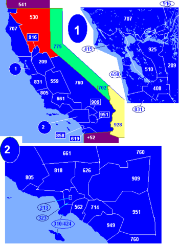
Area code 530
Encyclopedia
California
California is a state located on the West Coast of the United States. It is by far the most populous U.S. state, and the third-largest by land area...
telephone
Telephone
The telephone , colloquially referred to as a phone, is a telecommunications device that transmits and receives sounds, usually the human voice. Telephones are a point-to-point communication system whose most basic function is to allow two people separated by large distances to talk to each other...
area code that covers Auburn
Auburn, California
Auburn is the county seat of Placer County, California. Its population at the 2010 census was 13,330. Auburn is known for its California Gold Rush history.Auburn is part of the Greater Sacramento area.- History :...
, Chico
Chico, California
Chico is the most populous city in Butte County, California, United States. The population was 86,187 at the 2010 census, up from 59,954 at the time of the 2000 census...
, Colfax
Colfax, California
Colfax is a city in Placer County, California, at the crossroads of Interstate 80 and State Route 174. It is part of the Sacramento–Arden-Arcade–Roseville Metropolitan Statistical Area. The population was 1,963 at the 2010 census...
, Davis
Davis, California
Davis is a city in Yolo County, California, United States. It is part of the Sacramento–Arden-Arcade–Roseville Metropolitan Statistical Area...
, Grass Valley
Grass Valley, California
-2010:The 2010 United States Census reported that Grass Valley had a population of 12,860. The population density was 2,711.3 people per square mile . The racial makeup of Grass Valley was 11,493 White, 46 African American, 208 Native American, 188 Asian, 9 Pacific Islander, 419 from other...
, Marysville
Marysville, California
Marysville is the county seat of Yuba County, California, United States. The population was 12,072 at the 2010 census, down from 12,268 at the 2000 census. It is included in the Yuba City Metropolitan Statistical Area, often referred to as the Yuba-Sutter Area after the two counties, Yuba and...
, Oroville
Oroville, California
Oroville is the county seat of Butte County, California. The population was 15,506 at the 2010 census, up from 13,004 at the 2000 census...
, Placerville
Placerville, California
Placerville is the county seat of El Dorado County, California. The population was 10,389 at the 2010 census, up from 9,610 at the 2000 census. It is part of the Sacramento–Arden-Arcade–Roseville Metropolitan Statistical Area.-Geography:...
, Redding
Redding, California
Redding is a city in far-Northern California. It is the county seat of Shasta County, California, USA. With a population of 89,861, according to the 2010 Census...
, Red Bluff
Red Bluff, California
Red Bluff is a city in and the county seat of Tehama County, California, United States. The population was 14,076 at the 2010 census, up from 13,147 at the 2000 census....
, Susanville
Susanville, California
Susanville is the county seat of Lassen County, California, United States. Susanville is located on the Susan River in the south-central part of the county, at an elevation of 4186 feet . The population was 17,974 at the 2010 census, up from 13,541 at the 2000 census...
, Truckee
Truckee, California
Truckee is an incorporated town in Nevada County, California, United States. The population was 16,180 at the 2010 census, up from 13,864 at the 2000 census.-Name:...
, Woodland
Woodland, California
Woodland is the county seat of Yolo County, California, located approximately northwest of Sacramento, and is a part of the Sacramento - Arden-Arcade - Roseville Metropolitan Statistical Area. The population was 55,468 at the 2010 census.Woodland's origins trace back to 1850 when California...
, Yuba City
Yuba City, California
Yuba City is a Northern California city, founded in 1849. It is the county seat of Sutter County, California, United States. The population was 64,925 at the 2010 census....
and South Lake Tahoe
South Lake Tahoe, California
South Lake Tahoe is the most populous city in El Dorado County, California, in the Sierra Nevada Mountains. The population was 21,403 at the 2010 census, down from 23,609 at the 2000 census...
.
530 was created on Nov. 1, 1997, when it was split from the 916
Area code 916
North American area code 916 is an area code based in Sacramento, California. The telephone area code was one of the first three original area codes established in California in October, 1947. It covered the far northern portion of the state. It was split in a flash-cut on October, 26, 1957, at...
area code. On the same day, the Dixon
Dixon, California
Dixon is a city in northern Solano County, California, United States, located from the state capital, Sacramento. The population was 18,351 at the 2010 census. Other nearby cities include Vacaville, Winters and Davis....
exchange was moved from Sacramento LATA
Local access and transport area
Local access and transport area is a term used in U.S. telecommunications regulation. It represents a geographical area of the United States under the terms of the that precipitated the breakup of the original AT&T into the "Baby Bells" or created since that time for wireline...
to San Francisco LATA and from the 916 area code to 707
Area code 707
North American area code 707 is a Californian telephone area code which covers Napa, Sebastopol, Vallejo, Benicia, Fairfield, Santa Rosa, Petaluma, Fort Bragg, Crescent City, Eureka, Clearlake, Vacaville, Ukiah, and northwestern California. It was split from area code 415 on March 1, 1959...
.
Alpine CountyAlpine County, CaliforniaAlpine County is the smallest county, by population, in the U.S. state of California. As of 2010, it had a population of 1,175, all rural. There are no incorporated cities in the county. The county seat is Markleeville...
- Alpine VillageAlpine Village, CaliforniaAlpine Village is a census-designated place in Alpine County, California, United States. The population was 114 at the 2010 census, down from 136 at the 2000 census.-Geography:...
- Bear ValleyBear Valley, CaliforniaBear Valley is a census-designated place in Alpine County, California. The population was 121 at the 2010 census, down from 133 at the 2000 census. The town is accessible by State Route 4. Bear Valley is within the Stanislaus National Forest...
- MarkleevilleMarkleeville, CaliforniaMarkleeville is a census-designated place and the county seat of Alpine County, California. The population was 210 at the 2010 census, up from 197 at the 2000 census.The CDP of Markleeville also includes Woodfords....
- Mesa VistaMesa Vista, CaliforniaMesa Vista is a census-designated place in Alpine County, California, United States. The population was 200 at the 2010 census, up from 182 at the 2000 census.-Geography:...
- WoodfordsWoodfords, CaliforniaWoodfords is an unincorporated community in Alpine County, California, near Markleeville. For census purposes, it is included in Alpine Village...
Butte CountyButte County, CaliforniaButte County is a county located in the Central Valley of the US state of California, north of the state capital of Sacramento. As of the 2010 census, it had a population of 220,000. The county seat is Oroville. Butte County is the "Land of Natural Wealth and Beauty."Butte County is watered by the...
- BangorBangor, CaliforniaBangor is a census-designated place inside Butte County, California, about from the Yuba County line. The U.S. Geological Survey feature ID for the community is 218644, and for the census place is 2612459; and the elevation is given as above mean sea level . The community is in a shallow valley...
- Berry CreekBerry Creek, CaliforniaBerry Creek is a census-designated place about northeast of Oroville, California in hilly terrain at above mean sea level. The community is located along Oroville-Quincy Highway on the shore of Madrone Lake. The US Geological Survey shows coordinates of for the town. The community is home to...
- BiggsBiggs, CaliforniaBiggs is a city in Butte County, California, United States. The population was 1,707 at the 2010 census, down from 1,793 at the 2000 census.- Geography :Biggs is located at ....
- Brush CreekBrush Creek, CaliforniaBrush Creek is an unincorporated community near Oroville in Butte County, California, United States....
- Butte MeadowsButte Meadows, CaliforniaButte Meadows is a census-designated place in Butte County, California, 5 miles off State Route 32 on Humboldt Rd. The area is about 45 minutes or east of Chico on SR32. Its elevation is listed at above sea level: certain to get snow in winter of any year. The area code is Area code 530. The area...
- Camp EighteenCamp Eighteen, CaliforniaCamp Eighteen is an unincorporated community in Butte County, California, about from the Plumas County line. It lies north of Clipper Mills, at an elevation of 3947 feet . The ZIP Code is 95940. The community is inside area code 530. Nearby communities are Lumpkin and Rogerville...
- CentervilleCenterville, Butte County, CaliforniaCenterville is an unincorporated community in Butte County, California along Butte Creek. It was midway between Helltown and Diamondville. The area is about one and three quarters miles, straight-line distance, west of Paradise. The US Geological Survey defines it as a populated place with a...
- CherokeeCherokee, CaliforniaCherokee is a census-designated place in Butte County, California An area inhabited by Maidu Indians prior to the gold rush. But that conversly takes its name from a band of Cherokee prospectors who perfected a mining claim on the site. The population was 69 at the 2010 census...
- ChicoChico, CaliforniaChico is the most populous city in Butte County, California, United States. The population was 86,187 at the 2010 census, up from 59,954 at the time of the 2000 census...
- CohassetCohasset, CaliforniaCohasset is a census-designated place in Butte County, California, United States, approximately NNE of Chico, California. Its main street is named Cohasset Road, which comes from the Algonquian Indian language and means "long rocky place"...
- ConcowConcow, CaliforniaConcow is an unincorporated community and census-designated place in Butte County, California, United States. It is named after the Native American tribe that is indigenous to the area, the Concow Maidu...
- DaytonDayton, CaliforniaDayton is a small unincorporated community in Butte County, California. Its zip code is 95926 and its area code is 530. It lies at an elevation of 141 feet .- History :...
- DeSablaDeSabla, CaliforniaDeSabla is an unincorporated community in Butte County, California. It lies at an elevation of 2762 feet . It was named after one of the Pacific Gas and Electric founders and is the site of Lake de Sabla reservoir and a powerhouse named for him...
- DurhamDurham, CaliforniaDurham is a census-designated place in Butte County, California, United States. The population was 5,518 at the 2010 census.-Geography:...
- East BiggsEast Biggs, CaliforniaEast Biggs is a small unincorporated community in Butte County, California. Its zip code is 95917 and its area code is 530. It lies at an elevation of 121 feet .The town was founded on the Northern Electric Railroad...
- Feather FallsFeather Falls, CaliforniaFeather Falls is a rural unincorporated community in Butte County, California north and east of Lake Oroville. It lies at an elevation of 2982 feet . It is home to Feather Falls Elementary School, a K-8 facility...
- ForbestownForbestown, CaliforniaForbestown is a census-designated place in Butte County, California. It lies at an elevation of 2772 feet . Its zip code is 95941 and its area code is 530. Forbestown had a population of 320 at the 2010 census.Forbestown is named for B.F. Forbes, who opened a store there in 1850...
- Forest RanchForest Ranch, CaliforniaForest Ranch is a census-designated place in Butte County, California. It includes Forest Ranch Elementary School , its own post office, and a CDF fire station. The community's ZIP code is 95942, and is shared with the community of Butte Meadows. The area code is 530...
- GridleyGridley, CaliforniaGridley is a city in Butte County, California, United States. The population was 6,584 at the 2010 census, up from 5,382 at the 2000 census.-History:...
- InskipInskip, CaliforniaInskip is an unincorporated community in Butte County, California. It lies at an elevation of 4777 feet . Historical variants to the name suggest the community's history may have included mining. Variant names listed include Enskeeps Diggins and Inskip Town. The town was named in 1857 for the...
- MagaliaMagalia, CaliforniaMagalia is a census-designated place in Butte County, California, United States. The population was 11,310 at the 2010 census.-History:...
- MerrimacMerrimac, CaliforniaMerrimac is an unincorporated community in Butte County, California located along Oroville-Quincy Road about south of the Plumas County line. It lies at an elevation of 3999 feet...
- NordNord, CaliforniaNord is a census-designated place in Butte County, California. Its zip code is 95926 and its area code is 530. It lies at an elevation of 151 feet...
- Oregon CityOregon City, CaliforniaOregon City , an unincorporated area between Oroville and Cherokee in Butte County, California, was one of the first mining camps in the county. It was established in the autumn of 1848 by a party of Oregonians, who came to California over the Applegate and Lassen Trails. Little more than a year...
- Oroville EastOroville East, CaliforniaOroville East or Kelly Ridge is a census-designated place in Butte County, California, United States. The population was 8,280 at the 2010 census, down from 8,680 at the 2000 census...
- OrovilleOroville, CaliforniaOroville is the county seat of Butte County, California. The population was 15,506 at the 2010 census, up from 13,004 at the 2000 census...
- PalermoPalermo, CaliforniaPalermo is a census-designated place in Butte County, California, United States. The population was 5,382 at the 2010 census, down from 5,720 at the 2000 census.-Geography:...
- ParadiseParadise, CaliforniaParadise is an incorporated town in Butte County, in the northwest foothills of California's Central Valley, in the Sierra. The town is considered part of the Chico Metropolitan Area. The population was 26,218 at the 2010 census, down from 26,408 at the 2000 census...
- PulgaPulga, CaliforniaPulga is an unincorporated community in Butte County, California. It is located along the west slope of the Feather River canyon, at an elevation of 1398 feet . A variant name for the community is Big Bar. Other nearby communities include Mayaro, Poe and Parkhill. The town hosts a Caltrans highway...
- RichvaleRichvale, CaliforniaRichvale is a small census-designated place in Butte County, California, USA, south of Chico and west of Oroville. The primary crop grown in the area surrounding Richvale is rice, irrigated from the Oroville Dam on the Feather River. Several farmers in the area are known for organic farming...
- South OrovilleSouth Oroville, CaliforniaSouth Oroville is a census-designated place in Butte County, California, United States. The population was 5,742 at the 2010 census, down from 7,695 at the 2000 census.For all practical purposes, South Oroville is tied to Oroville proper...
- Stirling CityStirling City, CaliforniaStirling City is a census-designated place in Butte County, California, located on Paradise Ridge in the western foothills of the Sierra Nevada. Contrary to its name, Stirling City is an unincorporated community. Its ZIP Code is 95978 and area code 530. It lies at an elevation of 3570 feet...
- ThermalitoThermalito, CaliforniaThermalito is a census-designated place in Butte County, California, United States. The population was 6,646 at the 2010 census, up from 6,045 at the 2000 census...
Colusa CountyColusa County, CaliforniaColusa County is a county located in the Central Valley of the U.S. state of California, northwest of state capital Sacramento. As of the 2010 census, its population was 21,419. The county seat is Colusa.-History:...
- ArbuckleArbuckle, CaliforniaArbuckle is a census-designated place in Colusa County, California, United States. The population was 3,028 at the 2010 census, up from 2,332 at the 2000 census. The town entrance sign on I-5 only says 864 people, but it's very old and hasn't been updated...
- College CityCollege City, CaliforniaCollege City is a census-designated place in Colusa County, California. It lies at an elevation of 72 feet . Its zip code is 95912 and its area code is 530. College City's population is 290.-History:The post office was established in 1873...
- ColusaColusa, CaliforniaColusa is the county seat of Colusa County, California. The population was 5,971 at the 2010 census, up from 5,402 at the 2000 census.-Geography:...
- GrimesGrimes, CaliforniaGrimes is a census-designated place in Colusa County, California on the Southern Pacific Railroad. It lies at an elevation of 46 feet . Its zip code is 95950 and its area code is 530. Grimes's population was 391 at the 2010 census.-History:The post office was established in 1883...
- MaxwellMaxwell, CaliforniaMaxwell is a census-designated place and farm community in Colusa County, California. It lies at an elevation of 92 feet . Located off Interstate 5, it is home to Maxwell High School. The main crop grown is rice, though a variety of others such as grapes, almonds, squash, and sunflowers are grown...
- PrincetonPrinceton, CaliforniaPrinceton is a census-designated place in Colusa County, California. It lies at an elevation of 82 feet . Its zip code is 95970 and its area code is 530. Princeton's population was 303 at the 2010 census.-Demographics:...
- SitesSites, CaliforniaSites is an unincorporated community in Colusa County, California. It lies at an elevation of 299 feet .Its ZIP code is 95979 and its area code is 530....
- StonyfordStonyford, CaliforniaStonyford is a census-designated place in Colusa County, California. It lies at an elevation of 1184 feet . Its zip code is 95979 and its area code is 530. Stonyford's population was 149 at the 2010 census.-Demographics:...
- WilliamsWilliams, CaliforniaWilliams is a city in Colusa County, California, United States. The population was 5,123 at the 2010 census, up from 3,670 at the 2000 census. It is a traveler's city with many fast food restaurants, motels, and gas stations...
El Dorado CountyEl Dorado County, CaliforniaEl Dorado County is a county located in the historic Gold Country in the Sierra Nevada Mountains and foothills of the U.S. state of California. The 2010 population was 181,058. The El Dorado county seat is in Placerville....
- Cameron ParkCameron Park, CaliforniaCameron Park is a census-designated place in El Dorado County, California, United States and is part of the Sacramento metropolitan area. The population was 18,228 at the 2010 census, up from 14,549 at the 2000 census...
- CaminoCamino, CaliforniaCamino is a census-designated place in El Dorado County, California, and, per the 2010 census, has a population of 1,750...
- ColomaColoma, CaliforniaColoma is a census-designated place in El Dorado County, California, USA. It is approximately northeast of Sacramento, California. Coloma is most noted for being the site where James W. Marshall first discovered gold in California, at Sutter's Mill on January 24, 1848, leading to the California...
- CoolCool, CaliforniaCool, formerly known as Cave Valley, is a small unincorporated community in El Dorado County, California, about from Sacramento, the state capital...
- Diamond SpringsDiamond Springs, CaliforniaDiamond Springs is a census-designated place in El Dorado County, California, United States. It is part of the Sacramento–Arden-Arcade–Roseville Metropolitan Statistical Area. The population was 11,037 at the 2010 census, up from 4,888 at the 2000 census. The town is registered as...
- Ditch Camp FiveDitch Camp Five, CaliforniaDitch Camp Five is an unincorporated community in El Dorado County, California. It is located east of Pollock Pines, at an elevation of 3842 feet . The ZIP code is 95628. The community is inside area code 530....
- Echo LakeEcho Lake, CaliforniaEcho Lake is a small unincorporated community in El Dorado County, California, United States, along U.S. Highway 50 in the mountains of the Sierra Nevada. It is north-northwest of Echo Summit. Echo Lake's nearest neighboring town is Little Norway. The ZIP code is 95721. The community is inside...
- El DoradoEl Dorado, CaliforniaEl Dorado , not to be confused with the nearby El Dorado Hills, is an unincorporated community in El Dorado County, California. It is located southwest of Placerville, at an elevation of 1608 feet . The population was 4,096 at the 2000 census...
- Fresh PondFresh Pond, CaliforniaFresh Pond is a small unincorporated community in El Dorado County, California. It is located east of Pollock Pines, at an elevation of 3606 feet . The ZIP code is 95726. The community is inside area code 530....
- Garden ValleyGarden Valley, El Dorado County, CaliforniaGarden Valley is an unincorporated community in El Dorado County, California. It is located on Johntown Creek north-northwest of Chili Bar, at an elevation of 1949 feet ....
- GeorgetownGeorgetown, CaliforniaGeorgetown is a census-designated place in El Dorado County, California. It is the northeastern-most town in the Californian Mother Lode. The population was 2,367 at the 2010 census, up from 962 at the 2000 census...
- KyburzKyburz, CaliforniaKyburz is a small unincorporated community in El Dorado County, California. It is located along the South Fork of the American River and U.S. Highway 50, and is surrounded by the El Dorado National Forest...
- Little NorwayLittle Norway, CaliforniaLittle Norway is a small unincorporated community in El Dorado County, California. It is located west of Meyers, at an elevation of 7326 feet . The ZIP code is 95721. The community is inside area code 530.A post office was established at Little Norway in 1961....
- MeyersMeyers, CaliforniaMeyers is a small unincorporated community in El Dorado County, California, United States, along U.S. Route 50 in the foothills of the Sierra Nevada south of South Lake Tahoe in the Lake Tahoe area. It lies at an elevation of 6352 feet...
- NebelhornNebelhorn, CaliforniaNebelhorn is a small unincorporated community in El Dorado County, California, United States. It lies at an elevation of 7401 feet . Nebelhorn is just southwest of Echo Summit. The ZIP code is 95735. The community is inside area code 530....
- Newtown
- Pacific HousePacific House, CaliforniaPacific House is a small unincorporated community in El Dorado County, California, United States. It lies along Highway 50 and is next to the town of Pacific, California. The ZIP code is 95726. The community is inside area code 530....
- PacificPacific, CaliforniaPacific is a small unincorporated community in El Dorado County, California. It is located east of Pollock Pines, at an elevation of 3396 feet . It lies along U.S. Highway 50 and is next to the town of Pacific House, California. The ZIP code is 95726...
- PhillipsPhillips, CaliforniaPhillips is a small unincorporated community in El Dorado County, California. It is located on the South Fork of the American River west of Echo Summit, at an elevation of 6873 feet . It is the site of the Sierra-at-Tahoe ski resort. The ZIP code is 95720...
- PlacervillePlacerville, CaliforniaPlacerville is the county seat of El Dorado County, California. The population was 10,389 at the 2010 census, up from 9,610 at the 2000 census. It is part of the Sacramento–Arden-Arcade–Roseville Metropolitan Statistical Area.-Geography:...
- Pollock PinesPollock Pines, CaliforniaPollock Pines is a census-designated place in El Dorado County, California, United States. It is part of the Sacramento–Arden-Arcade–Roseville Metropolitan Statistical Area...
- RescueRescue, CaliforniaRescue is an unincorporated community in El Dorado County, California. It is located north-northwest of Shingle Springs, Rescue consists of primarily farmland and ranches with a few residential neighborhoods and businesses. Downtown Rescue is quite small, with only a post office, fire station, two...
- RivertonRiverton, CaliforniaRiverton is a small unincorporated community in El Dorado County, California. It is located on the South Fork of the American River west of Kyburz, at an elevation of 3238 feet . The ZIP code is 95726. The community is inside area code 530.The place was on a toll road operated by John M...
- Sciots CampSciots Camp, CaliforniaSciots Camp is a small unincorporated community in El Dorado County, California. It is located on the South Fork of the American River south of Pyramid Peak, at an elevation of 5659 feet . The ZIP code is 95610. The community is inside area code 530....
- Shingle SpringsShingle Springs, CaliforniaShingle Springs is a census-designated place in El Dorado County, California, United States. The population was 4,432 at the 2010 census, up from 2,643 at the 2000 census. It is located about 40 miles from Sacramento in the historic Gold Country foothills and sits directly on Highway 50...
- South Lake TahoeSouth Lake Tahoe, CaliforniaSouth Lake Tahoe is the most populous city in El Dorado County, California, in the Sierra Nevada Mountains. The population was 21,403 at the 2010 census, down from 23,609 at the 2000 census...
- Twin BridgesTwin Bridges, CaliforniaTwin Bridges is a small unincorporated community on U.S. Route 50 near the Desolation Wilderness in El Dorado County, California. It is located west of Echo Summit, at an elevation of 6115 feet . It has a population of 14 people according to census figures, however as of 2008 the road sign lists...
- White HallWhite Hall, CaliforniaWhite Hall is a small unincorporated community in El Dorado County, California, United States. It is located on the South Fork of the American River east of Riverton, at an elevation of 3383 feet . The ZIP code is 95726. The community is inside area code 530.A post office operated at Randall from...
Glenn CountyGlenn County, CaliforniaGlenn County is in the California Central Valley. As of 2010, it had a population of 28,122. The county seat is the city of Willows.-History:Glenn County was formed in 1891 from parts of Colusa County. It was named for Dr. Hugh J...
- ArtoisArtois, CaliforniaArtois is a census-designated place in Glenn County, California. It is located north of Willows, at an elevation of 167 feet , in the northern Sacramento Valley of California. It is located on the former US Highway 99W, and is bypassed to the west by Interstate Highway 5...
- GlennGlenn, CaliforniaGlenn is an unincorporated community in Glenn County, California. It lies at an elevation of 98 feet .. The town is located on the Sacramento River, at the intersection of State Route 45 and State Route 162. It is about ten miles east of Interstate 5 and Willows on the U.S. Geological Survey...
- Hamilton CityHamilton City, CaliforniaHamilton City is a census-designated place in Glenn County, California, United States. The population was 1,759 at the 2010 census, down from 1,903 at the 2000 census. Hamilton City is located east of Orland, and 10 miles west of Chico at an elevation of 151 feet . The default numbers used for...
- OrdbendOrdbend, CaliforniaOrdbend is a small unincorporated community about above mean sea level in Glenn County, California. For road traffic, Ordbend is along State Route 45 between Glenn and Hamilton City. It's about eight miles south of Hamilton City. The ZIP Code, shared with Glenn and Bayliss, is 95943. The...
- OrlandOrland, CaliforniaOrland is a city in Glenn County, California. The population was 7,291 at the 2010 census, up from 6,281 at the 2000 census, making Orland the most populous city in Glenn County. Orland is located north of Willows, at an elevation of 259 feet . Interstate 5, passes west of the downtown area while...
- WillowsWillows, CaliforniaWillows is the county seat of Glenn County, California. As the county seat, the city is a home to regional government offices, including the California Highway Patrol, California Department of Motor Vehicles and the United States Bureau of Reclamation...
Lassen CountyLassen County, CaliforniaLassen County is a county located in the northeastern portion of the U.S. state of California. As of the 2010 census, the population was 34,895, up from 33,828 at the 2000 census...
- BieberBieber, CaliforniaBieber is a census-designated place in Lassen County, California. It is located on the Pit River north-northwest of Susanville, at an elevation of 4124 feet . Its population was 312 at the 2010 census. The ZIP Code is 96009. The community is inside area code 530.-History:The settlement sprang up...
- Doyle
- HerlongHerlong, CaliforniaHerlong is a census-designated place in Lassen County, California. It is located north of Doyle, at an elevation of 4114 feet . Herlong is located in southern Lassen County near the southeast edge of Honey Lake about north of Reno, Nevada, and about south of Susanville. The community is...
- JanesvilleJanesville, CaliforniaJanesville is a census-designated place in Lassen County, California. It is located southeast of Susanville, at an elevation of 4239 feet . Janesville is located on the eastern slopes of the Sierra Nevada Mountain range...
- RavendaleRavendale, CaliforniaRavendale is an unincorporated community in Lassen County, California. It is located southeast of Termo, at an elevation of 5305 feet...
- SusanvilleSusanville, CaliforniaSusanville is the county seat of Lassen County, California, United States. Susanville is located on the Susan River in the south-central part of the county, at an elevation of 4186 feet . The population was 17,974 at the 2010 census, up from 13,541 at the 2000 census...
- TermoTermo, CaliforniaTermo is an unincorporated community in Lassen County, California. It is located on the Southern Pacific Railroad north-northeast of Susanville, at an elevation of 5305 feet . This town straddles U.S. Highway 395 north of Ravendale.In 1909, Termo was the terminus of the Nevada–California–Oregon...
- WestwoodWestwood, CaliforniaWestwood is a census-designated place in Lassen County, California, United States. Westwood is located west-southwest of Susanville, at an elevation of 5128 feet...
Modoc CountyModoc County, CaliforniaModoc County is a county located in the far northeast corner of the U.S. state of California, bounded by the state of Oregon to the north and the state of Nevada to the east. As of the 2010 census, its population was 9,686, up from 9,449 at the 2000 census. The current county seat is Alturas, the...
- AdinAdin, CaliforniaAdin is a census-designated place in Modoc County, California. It is located southwest of Alturas, at an elevation of 4203 feet...
- AlturasAlturas, CaliforniaAlturas is the county seat of Modoc County, California, United States. Alturas is located on the Pit River, east of the center of Modoc County, at an elevation of 4370 feet...
- CanbyCanby, CaliforniaCanby is a census-designated place in Modoc County, California. It is located west of Alturas, at an elevation of 4314 feet . It had a population of 315 at the 2010 census. The ZIP Code is 96015...
- CedarvilleCedarville, CaliforniaCedarville is a census-designated place in Modoc County, California. It is located east of Alturas, at an elevation of 4652 feet ....
- Davis CreekDavis Creek, CaliforniaDavis Creek is an unincorporated community in Modoc County, California. It is located on the north-northeast of Alturas, at an elevation of 4846 feet . The town's population is at least 100. There is a post office, service station, and mini-mart housed in a single structure. The ZIP Code is 96108...
- EaglevilleEagleville, Modoc County, CaliforniaEagleville is a census-designated place in Modoc County, California. It is located east-southeast of Alturas, at an elevation of 4642 feet . The population was 59 at the 2010 census....
- Fort BidwellFort Bidwell, CaliforniaFort Bidwell is a census-designated place in Modoc County, California. It is located northeast of Alturas, at an elevation of 4564 feet . The population was 173 at the 2010 census.-Geography:...
- NewellNewell, CaliforniaNewell is a census-designated place in Modoc County, California in the United States. It is located west-northwest of Alturas, at an elevation of 4,042 feet . The population was 449 at the 2010 census....
- StrongholdStronghold, CaliforniaStronghold is an unincorporated community in Modoc County, California. It is located on the Southern Pacific Railroad northwest of Newell, at an elevation of 4035 feet ....
- TionestaTionesta, CaliforniaTionesta is an unincorporated community in Modoc County, California. It is located on the former Great Northern Railway Bieber Line northwest of Timber Mountain, at an elevation of 4278 feet ....
Nevada CountyNevada County, CaliforniaNevada County is a county located in the Sierra Nevada of California, in the Mother Lode country. As of 2010 its population was 98,764. The county seat is Nevada City.-History:Nevada County was created in 1851 from parts of Yuba County....
- Alta Sierra
- Grass ValleyGrass Valley, California-2010:The 2010 United States Census reported that Grass Valley had a population of 12,860. The population density was 2,711.3 people per square mile . The racial makeup of Grass Valley was 11,493 White, 46 African American, 208 Native American, 188 Asian, 9 Pacific Islander, 419 from other...
- Lake of the PinesLake of the Pines, CaliforniaLake of the Pines is a census-designated place and a gated residential community in Nevada County, California, United States. The population was 3,917 at the 2010 census, down from 3,956 at the 2000 census.-Geography:...
- Lake WildwoodLake Wildwood, CaliforniaLake Wildwood is a census-designated place in Nevada County, California, United States. The population was 4,991 at the 2010 census, up from 4,868 at the 2000 census....
- Nevada CityNevada City, California-2010:The 2010 United States Census reported that Nevada City had a population of 3,068. The population density was 1,399.7 people per square mile . The racial makeup of Nevada City was 2,837 White, 26 African American, 28 Native American, 46 Asian, 0 Pacific Islander, 40 from other races,...
- Penn Valley
- Rough and ReadyRough and Ready, CaliforniaRough and Ready is a census-designated place in Nevada County, California, United States. It is located west of Grass Valley, California, approximately 62 miles from Sacramento...
- TruckeeTruckee, CaliforniaTruckee is an incorporated town in Nevada County, California, United States. The population was 16,180 at the 2010 census, up from 13,864 at the 2000 census.-Name:...
- WashingtonWashington, CaliforniaWashington is a census-designated place located in Nevada County, California. Washington is located on the banks of the South Fork of The Yuba River and has a population of approximately two hundred people...
Placer CountyPlacer County, CaliforniaPlacer County is a county located in both the Sacramento Valley and Sierra Nevada regions of the U.S. state of California, in what is known as the Gold Country. It stretches from the suburbs of Sacramento to Lake Tahoe and the Nevada border. Because of the expansion of the Greater Sacramento,...
- AltaAlta, CaliforniaAlta is a small unincorporated community and census-designated place in Placer County, California, United States, about northeast of Auburn. The village is located off Interstate 80 and along the historical First Transcontinental Railroad. The ZIP code is 95701 and the area code 530...
- ApplegateApplegate, CaliforniaApplegate is an unincorporated community in Placer County, California. Applegate is located south-southwest of Colfax.It lies at an elevation of 2005 feet . Its ZIP code is 95703 and its area code 530....
- AuburnAuburn, CaliforniaAuburn is the county seat of Placer County, California. Its population at the 2010 census was 13,330. Auburn is known for its California Gold Rush history.Auburn is part of the Greater Sacramento area.- History :...
- Carnelian BayCarnelian Bay, CaliforniaCarnelian Bay is a census-designated place located on the shore of Lake Tahoe in Placer County, California, in the United States. The elevation is . The population was 524 at the 2010 census....
- ColfaxColfax, CaliforniaColfax is a city in Placer County, California, at the crossroads of Interstate 80 and State Route 174. It is part of the Sacramento–Arden-Arcade–Roseville Metropolitan Statistical Area. The population was 1,963 at the 2010 census...
- Dollar PointDollar Point, CaliforniaDollar Point is a census-designated place in Placer County, California, United States, along the northwest shore of Lake Tahoe. It is part of the Sacramento–Arden-Arcade–Roseville Metropolitan Statistical Area...
- Dutch FlatDutch Flat, CaliforniaDutch Flat is a small unincorporated community and census-designated place in Placer County, California, United States, about northeast of Auburn along Interstate 80. It was founded by German immigrants in 1851 and was once one of the richest gold mining locations of California...
- ForesthillForesthill, CaliforniaForesthill is a census-designated place in Placer County, California, United States. It is part of the Sacramento–Arden-Arcade–Roseville Metropolitan Statistical Area...
- Gold Run, CaliforniaGold Run, California-History:A post office was established titled "Mountain Springs", after the Mountain Springs Hotel, in 1854, a few miles southwest of Dutch Flat. The town was founded by O. W. Hollenbeck, and was known for its hydraulic mines. The post office moved one mile north and the name was changed to Gold...
- HomewoodHomewood, CaliforniaHomewood is an unincorporated community in Placer County, California of about 200 residents, located on the west shore of Lake Tahoe. It is located south of Tahoe City and north of Chambers Landing and Tahoma. It is the location of Homewood Mountain Resort...
- Kings BeachKings Beach, CaliforniaKings Beach is a census-designated place in Placer County, California, United States on the north shore of Lake Tahoe. It is part of the Sacramento–Arden-Arcade–Roseville Metropolitan Statistical Area. The population was 3,796 at the 2010 census, down from 4,037 at the 2000 census.The...
- Meadow VistaMeadow Vista, CaliforniaMeadow Vista is a census-designated place in Placer County, California, United States. It is part of the Sacramento–Arden-Arcade–Roseville Metropolitan Statistical Area...
- Sheridan
- Squaw Valley
- Sunnyside-Tahoe CitySunnyside-Tahoe City, CaliforniaSunnyside-Tahoe City is a census-designated place in Placer County, California, located on the northwest shore of Lake Tahoe. It is part of the Sacramento–Arden-Arcade–Roseville Metropolitan Statistical Area...
- Tahoe VistaTahoe Vista, CaliforniaTahoe Vista is a census-designated place located on the north shore of Lake Tahoe in Placer County, California. It is part of the Sacramento–Arden-Arcade–Roseville Metropolitan Statistical Area...
- WeimarWeimar, CaliforniaWeimar is an unincorporated community in Placer County, California, located in the Sacramento area. Weimar is located south-southwest of Colfax....
Plumas CountyPlumas County, CaliforniaPlumas County is a county located in the Sierra Nevada of the U.S. state of California. The county gets its name from the Spanish words for the Feather River , which flows through the county. As of the 2010 census, the population 20,007, down from 20,824 at the 2000 census...
- AlmanorAlmanor, CaliforniaAlmanor is a census-designated place in Plumas County, California, United States. The population was 0 at the 2010 Census. Almanor is located south-southeast of Chester.-History:...
- BeckwourthBeckwourth, CaliforniaBeckwourth is a census-designated place in Plumas County, California, United States. Beckwourth is located on the Middle Fork Feather River east of Portola...
- BeldenBelden, CaliforniaBelden is a census-designated place in Plumas County, California, United States. Belden is located on the North Fork Feather River, southwest of Caribou. The population was 22 at the 2010 census, down from 26 at the 2000 census.-History:...
- BlairsdenBlairsden, CaliforniaBlairsden is a census-designated place in Plumas County, California, United States. Blairsden is located east-southeast of Quincy. The population was 39 at the 2010 census, down from 50 at the 2000 census.-History:...
- Bucks LakeBucks Lake, CaliforniaBucks Lake is a census-designated place in Plumas County, California, United States. Bucks Lake is located on the south shore of Bucks Lake, west-southwest of Quincy...
- C-RoadC-Road, CaliforniaC-Road is a census-designated place in Plumas County, California, United States. The population was 150 at the 2010 census, down from 152 at the 2000 census.-Geography:C-Road is located at ....
- CanyondamCanyondam, CaliforniaCanyondam is a census-designated place in Plumas County, California, United States. Canyondam is located near the dam that forms Lake Almanor, east-southeast of Almanor...
- CaribouCaribou, CaliforniaCaribou is a Census-designated place located in Plumas County, California, United States. As of the 2010 Census, the town had a population of 0. Caribou is located on the North Fork Feather River, south of Almanor...
- ChesterChester, CaliforniaChester is a census-designated place in Plumas County, California, United States. Chester is located on Lake Almanor, north-northwest of Quincy. The town is located along State Route 36. The US Postal Service ZIP code for the community is 96020...
- Chilcoot-VintonChilcoot-Vinton, CaliforniaChilcoot-Vinton is a census-designated place in Plumas County, California, United States. The population was 454 at the 2010 census, up from 387 at the 2000 census.-Geography:Chilcoot-Vinton is located at ....
- ClioClio, CaliforniaClio is a census-designated place in Plumas County, California, United States. Clio is located southeast of Quincy. The population was 66 at the 2010 census, down from 90 at the 2000 census.-History:...
- Crescent MillsCrescent Mills, CaliforniaCrescent Mills is a census-designated place in Plumas County, California, United States. Crescent Mills is located southeast of Greenville. The population was 196 at the 2010 census, down from 258 at the 2000 census.-History:In 1821 Mary A Zubea was born. Four years later Frank Joseph Stampfli...
- CrombergCromberg, CaliforniaCromberg is a census-designated place in Plumas County, California, United States. Cromberg is located on the Western Pacific Railroad, northwest of Blairsden...
- DellekerDelleker, CaliforniaDelleker is a census-designated place in Plumas County, California, USA. The population was 705 at the 2010 census, up from 674 at the 2000 census.-Geography:Delleker is located at ....
- East QuincyEast Quincy, CaliforniaEast Quincy is a census-designated place in Plumas County, California, United States. The population was 2,489 at the 2010 census, up from 2,398 at the 2000 census.-Geography:East Quincy is located at ....
- East ShoreEast Shore, CaliforniaEast Shore is a census-designated place in Plumas County, California, United States. The population was 156 at the 2010 census, down from 177 at the 2000 census.-Geography:...
- GraeagleGraeagle, CaliforniaGraeagle is a census-designated place in Plumas County, California, United States. The population was 737 at the 2010 census, down from 831 at the 2000 census.-History:...
- GreenhornGreenhorn, CaliforniaGreenhorn is a census-designated place in Plumas County, California, United States. The population was 236 at the 2010 census, up form 146 at the 2000 census.-Geography:Greenhorn is located at ....
- GreenvilleGreenville, CaliforniaGreenville is a census-designated place in Plumas County, California, United States, on the north-west side of Indian Valley. The population was 1,129 at the 2010 census, down from 1,160 at the 2000 census.-Geography:...
- Hamilton BranchHamilton Branch, CaliforniaHamilton Branch is a census-designated place in Plumas County, California, United States. The population was 587 at the 2000 census.-Geography:Hamilton Branch is located at , on the south-east shore of Lake Almanor....
- Indian FallsIndian Falls, CaliforniaIndian Falls is a census-designated place in Plumas County, California, United States. The population was 54 at the 2010 census, up from 37 at the 2000 census.-Geography:Indian Falls is located at ....
- Iron HorseIron Horse, CaliforniaIron Horse is a census-designated place in Plumas County, California, United States. The population was 297 at the 2010 census, down from 321 at the 2000 census.-Geography:Iron Horse is located at ....
- JohnsvilleJohnsville, CaliforniaJohnsville is a census-designated place in Plumas County, California, United States. The population was 20 at the 2010 census, down from 21 at the 2000 census.-Geography:Johnsville is located at ....
- KeddieKeddie, CaliforniaKeddie is a census-designated place in Plumas County, California, United States. The population was 66 at the 2010 census.-Geography:Keddie is located at ....
- La PorteLa Porte, CaliforniaLa Porte is a census-designated place in Plumas County, California, United States. The population was 26 at the 2010 census, down from 43 at the 2000 census.-Geography:La Porte is located at ....
- Lake Almanor Country ClubLake Almanor Country Club, CaliforniaLake Almanor Country Club is a census-designated place in Plumas County, California, United States. The population was 419 at the 2010 census, down from 847 at the 2000 census...
- Lake Almanor PeninsulaLake Almanor Peninsula, CaliforniaLake Almanor Peninsula is a census-designated place in Plumas County, California, United States. The population was 356 at the 2010 census, up from 336 at the 2000 census.-Geography:Lake Almanor Peninsula is located at ....
- Lake Almanor WestLake Almanor West, CaliforniaLake Almanor West is a census-designated place in Plumas County, California, United States. The population was 270 at the 2010 census, down from 329 at the 2000 census.-Geography:...
- Lake DavisLake Davis, CaliforniaLake Davis is a census-designated place in Plumas County, California, United States. The population was 23 at the 2000 census.-Geography:Lake Davis is located at ....
- Little Grass ValleyLittle Grass Valley, CaliforniaLittle Grass Valley is a lake located in Plumas County, California, USA. As of the 2010 census, the census-designated place had a total population of 2.-Geography:Little Grass Valley is located at 39°42'59" North, 120°58'35" West ....
- Meadow ValleyMeadow Valley, CaliforniaMeadow Valley is a census-designated place in Plumas County, California, United States. The population was 464 at the 2010 census, down from 575 at the 2000 census.-Geography:Meadow Valley is located at ....
- Mohawk VistaMohawk Vista, CaliforniaMohawk Vista is a census-designated place in Plumas County, California, United States. The population was 159 at the 2010 census, up from 121 at the 2000 census.-Geography:Mohawk Vista is located at ....
- PaxtonPaxton, CaliforniaPaxton is a census-designated place in Plumas County, California, United States. The population was 14 at the 2010 census, down from 21 at the 2000 census.-Geography:Paxton is located at ....
- Plumas EurekaPlumas Eureka, CaliforniaPlumas Eureka is a census-designated place in Plumas County, California, United States. The population was 320 at the 2000 census.-Geography:Plumas Eureka is located at ....
- PortolaPortola, CaliforniaPortola is the only incorporated city in Plumas County, California, United States. The population was 2,104 at the 2010 census, down from 2,227 at the 2000 census...
- PrattvillePrattville, CaliforniaPrattville is a census-designated place in Plumas County, California, United States. The population was 33 at the 2010 census, up from 28 at the 2000 census.-Geography:Prattville is located at ....
- QuincyQuincy, CaliforniaQuincy is a census-designated place and the county seat of Plumas County, California. The population was 1,728 at the 2010 census, down from 1,879 at the 2000 census. Quincy is named after the city of Quincy, Illinois...
- Spring GardenSpring Garden, CaliforniaSpring Garden is a census-designated place in Plumas County, California, United States. The population was 16 at the 2010 census, down from 55 at the 2000 census.-Geography:Spring Garden is located at ....
- StorrieStorrie, CaliforniaStorrie is a census-designated place in Plumas County, California and about 20 miles northeast of Lake Oroville. As of the 2010 Census, the CDP had a population of four.-Geography:...
- TaylorsvilleTaylorsville, CaliforniaTaylorsville is a census-designated place in Plumas County, California, United States. The population was 150 at the 2010 census, down from 154 at the 2000 census.-Geography:Taylorsville is located at ....
- TobinTobin, CaliforniaTobin is a census-designated place in Plumas County, California, United States. The population was 12 at the 2010 census, up from 11 at the 2000 census.-Geography:Tobin is located at ....
- TwainTwain, CaliforniaTwain is a census-designated place in Plumas County, California, United States. As of the 2010 census, the CDP population was 82, down from 87 at the 2000 census.-Geography:Twain is located at ....
- Valley RanchValley Ranch, CaliforniaValley Ranch is a census-designated place in Plumas County, California, United States. The population was 109 at the 2010 census, up from 92 at the 2000 census.-Geography:Valley Ranch is located at ....
- WhitehawkWhitehawk, CaliforniaWhitehawk is a census-designated place in Plumas County, California, United States. The population was 113 at the 2010 census, up from 96 at the 2000 census.-Geography:Whitehawk is located at ....
Shasta CountyShasta County, CaliforniaShasta County is a county located in the northern portion of the U.S. state of California. The county occupies the northern reaches of the Sacramento Valley, with portions extending into the southern reaches of the Cascade Range. As of the 2010 census, the population was 177,223, up from 163,256...
- AndersonAnderson, CaliforniaAnderson is a city in Shasta County, California, USA, approximately 10 miles south of Redding. The population was 9,932 at the 2010 census, up from 9,022 at the 2000 census....
- Bella VistaBella Vista, CaliforniaBella Vista is a census-designated place in Shasta County, California. Bella Vista is a small, rural community about north-east of Redding, and about north of Palo Cedro. Bella Vista sits at an elevation of...
- Big BendBig Bend, CaliforniaBig Bend is a census-designated place in Shasta County, California, United States. The population was 102 at the 2010 census, down from 149 at the 2000 census.-Geography:Big Bend is located at ....
- BurneyBurney, CaliforniaBurney is an unincorporated town and census-designated place in Shasta County, California, United States. The population was 3,154 at the 2010 census, down from 3,217 at the 2000 census...
- CasselCassel, CaliforniaCassel is a census-designated place in Shasta County, California. Cassel sits at an elevation of . The 2010 United States census reported Cassel's population was 207. The ZIP Code is 96016...
- CastellaCastella, CaliforniaCastella is a small, unincorporated town of 240 in the upper Sacramento Canyon of Shasta County, California. It is located 46 miles north of Redding on Interstate 5, and is home to Castle Crags State Park. It has a Chevron gas station/store and a post office. The ZIP Code is 96017...
- CottonwoodCottonwood, CaliforniaCottonwood is a census-designated place in Shasta County, California, United States. The population was 3,316 at the 2010 census, up from 2,960 at the 2000 census. Cottonwood is a stagecoach town founded in 1882. Cottonwood is equidistant between Redding and Red Bluff , in both directions...
- Fall River MillsFall River Mills, CaliforniaFall River Mills is an unincorporated town and census-designated place in Shasta County, California, United States. The population was 573 as of the 2010 census.-Production & Industry:The community is known for its agriculture...
- French GulchFrench Gulch, CaliforniaFrench Gulch is a census-designated place in Shasta County, California, United States. The population was 346 at the 2010 census, up from 254 at the 2000 census.-Geography:French Gulch is located at ....
- Hat CreekHat Creek, CaliforniaHat Creek is a census-designated place in Shasta County, California. Hat Creek sits at an elevation of . The 2010 United States census reported Hat Creek's population was 309....
- IgoIgo, CaliforniaIgo is an unincorporated town with 625 residents 9 miles west of Redding, CA. Its ZIP Code is 96047. Wired Telephone numbers follow the pattern 530-396-xxxx. It has a neighboring town of Ono 4.0 miles west. It is also home to the Northern California Veterans Cemetery, dedicated in December 2005...
- Lakehead-LakeshoreLakehead-Lakeshore, CaliforniaLakehead-Lakeshore is a census-designated place in Shasta County, California, United States. The population was 549 at the 2000 census. It is a very seasonal town with many Shasta Lake services, including a small grocery store, Subway restaurant inside the Shell gas station, and low-cost lodging...
- McArthurMcArthur, CaliforniaMcArthur is a census-designated place in Shasta County, California, United States. The population was 338 at the 2010 census, down from 365 at the 2000 census...
- MillvilleMillville, CaliforniaMillville is a census-designated place in Shasta County, California, United States. The population was 727 at the 2010 census, up from 610 at the 2000 census.-Geography:Millville is located at ....
- Montgomery CreekMontgomery Creek, CaliforniaMontgomery Creek is a census-designated place in Shasta County, California, United States. The population was 163 at the 2010 census, up from 96 at the 2000 census...
- Oak RunOak Run, CaliforniaOak Run is a small unincorporated community east of Redding in Shasta County, California. The towns of Bella Vista , Millville , Shingletown , Palo Cedro , Whitmore , and Round Mountain lie within a radius...
- Old StationOld Station, CaliforniaOld Station is a census-designated place in Shasta County, California. It is located 13 miles north of Lassen Volcanic National Park, directly in between Redding and Susanville. The ZIP code in Old Station is 96071 and the area code 530. Old Station sits at an elevation of...
- Palo CedroPalo Cedro, CaliforniaPalo Cedro is a census-designated place in Shasta County, California, United States. The population was 1,269 at the 2010 census, up from 1,247 at the 2000 census. It is east of Redding, California. The communities of Bella Vista , Millville , Shingletown , Oak Run , Whitmore , and Round...
- PlatinaPlatina, CaliforniaPlatina is a small unincorporated community of 200 people in Shasta County, California, approximately and equidistantly 40 miles west of Redding and Red Bluff. Its ZIP Code is 96076. Wired Telephone Numbers follow the pattern 530-352-xxxx.-History:...
- Pollard FlatPortuguese Flat, CaliforniaPortuguese Flat was a California mining camp of the early 1850s during the California Gold Rush, consisting largely of Portuguese miners. It was located about 35 miles north of Redding, California near what is currently now the unincorporated community of Pollard Flat...
- ReddingRedding, CaliforniaRedding is a city in far-Northern California. It is the county seat of Shasta County, California, USA. With a population of 89,861, according to the 2010 Census...
- Round MountainRound Mountain, CaliforniaRound Mountain is a census-designated place in Shasta County, California, United States. The population was 155 at the 2010 census, up from 122 at the 2000 census.-Geography:Round Mountain is located at ....
- Shasta Lake CityShasta Lake, CaliforniaShasta Lake or Shasta Lake City is a city in Shasta County, California, United States. It is the closest settlement to Lake Shasta and the Shasta Dam, which are popular tourist destinations...
- ShastaShasta, CaliforniaShasta is a census-designated place in Shasta County, California. Shasta sits at an elevation of . The 2010 United States census reported Shasta's population was 1,771....
- ShingletownShingletown, CaliforniaShingletown is a census-designated place in Shasta County, California, United States. The population was 2,283 at the 2010 census, up from 2,222 at the 2000 census....
- WhiskeytownWhiskeytown, CaliforniaWhiskeytown is an unincorporated community in Shasta County, California, United States. The ZIP Code is 96095. The community is inside area code 530. Although once a bustling mining town, there are very few people living in Whiskeytown as of today. The entire town of Whiskeytown was flooded to make...
- WhitmoreWhitmore, CaliforniaWhitmore is an unincorporated town of 166 people in the U.S. state of California. It is equidistantly north of Shingletown and east of Redding. Its zip code is 96096, and wired telephone numbers follow the pattern 530-472-xxxx, which is shared by the neighboring communities of Oak Run and Ingot...
Sierra CountySierra County, CaliforniaSierra County is a county located in the Sierra Nevada of the U.S. state of California, northeast of Sacramento on the border with Nevada. As of the 2010 census the population was 3,240, down from 3,555 at the 2000 census. The county seat is Downieville....
- AlleghanyAlleghany, CaliforniaAlleghany is a small census-designated place in Sierra County, California, United States in the Sierra Nevada mountains. It is situated in the Gold Country and continues to be a significant locale for gold mining. The famous Sixteen-to-One Mine has been in operation since the days of the...
- CalpineCalpine, CaliforniaCalpine is a census-designated place in Sierra County, California, United States. Calpine sits at an elevation of . The 2010 United States census reported Calpine's population was 205.-Geography:...
- DownievilleDownieville, CaliforniaDownieville is a census-designated place in and the county seat of Sierra County, California, United States. Downieville sits at an elevation of...
- LoyaltonLoyalton, CaliforniaLoyalton is a city in Sierra County, California, United States. The population was 769 at the 2010 census, down from 862 at the 2000 census. The ZIP code for the community is 96118. Wired telephone numbers in the community follow the format 993-xxxx. The town is near the north extent of State...
- Sierra CitySierra City, CaliforniaSierra City is a census-designated place in Sierra County, California, United States. The elevation of Sierra City is , and the town is situated in the canyon of the North Yuba River on California State Route 49, twelve miles northeast of the county seat of Sierra County, Downieville...
Siskiyou CountySiskiyou County, CaliforniaSiskiyou County is a county located in the far northernmost part of the U.S. state of California, in the Shasta Cascade region on the Oregon border. Yreka is the county seat. Because of its substantial natural beauty, outdoor recreation opportunities, and Gold Rush era history, it is an important...
- CarrickCarrick, CaliforniaCarrick is a census-designated place in Siskiyou County, California, United States. The population was 131 at the 2010 census, down from 156 at the 2000 census...
- DorrisDorris, CaliforniaDorris is a city in Siskiyou County, California, United States. The population was 939 at the 2010 census, up from 886 at the 2000 census.-Geography:...
- DunsmuirDunsmuir, CaliforniaDunsmuir is a city in Siskiyou County, California, United States. The population was 1,650 at the 2010 census, down from 1,923 at the 2000 census. It is currently a hub of tourism in Northern California as visitors enjoy fishing, skiing, climbing, or sight-seeing...
- EdgewoodEdgewood, CaliforniaEdgewood is a census-designated place in Siskiyou County, California, United States. The population was 43 at the 2010 census, down from 67 at the 2000 census...
- EtnaEtna, CaliforniaEtna is a city in the Scott Valley area of Siskiyou County, California, United States. The population was 737 at the 2010 census, down from 781 at the 2000 census.-Geography:...
- Forks of SalmonForks of Salmon, CaliforniaForks of Salmon is an unincorporated community of Siskiyou County in northern California, USA. The town is situated at the confluence of the north and south forks of the Salmon River, hence its name. The ZIP Code is 96031...
- Fort JonesFort Jones, CaliforniaFort Jones is a city in the Scott Valley area of Siskiyou County, California, United States. The population was 839 at the 2010 census, up from 600 as of the 2000 census.-History:...
- GazelleGazelle, CaliforniaGazelle is a census-designated place in Siskiyou County, California, United States. The population was 70 at the 2010 census, down from 136 at the 2000 census.-Geography:Gazelle is located at ....
- GreenviewGreenview, CaliforniaGreenview is a census-designated place in Siskiyou County, California, United States. The population was 201 at the 2010 census, up from 200 at the 2000 census.-Geography:Greenview is located at ....
- GrenadaGrenada, CaliforniaGrenada is a census-designated place in Siskiyou County, California, United States. The population was 367 at the 2010 census, up from 351 at the 2000 census...
- Happy CampHappy Camp, CaliforniaHappy Camp is a census-designated place in Siskiyou County, California in the United States. The population was 1,190 at the 2010 census....
- HornbrookHornbrook, CaliforniaHornbrook is a census-designated place in Siskiyou County, California, United States. The population was 248 at the 2010 census, down from 286 at the 2000 census.-Geography:Hornbrook is located at ....
- MacdoelMacdoel, CaliforniaMacdoel is a census-designated place in Siskiyou County, California, United States. As of the 2010 census, the CDP population was 133, down from 140 in at the 2000 census.-Geography:Macdoel is located at ....
- McCloudMcCloud, CaliforniaMcCloud is a small town and census-designated place in Siskiyou County, California, United States. The population was 1,101 at the 2010 census, down from 1,343 at the 2000 census.-Commerce and tourism:...
- MontagueMontague, CaliforniaMontague is a city in Siskiyou County, California, United States. The population was 1,443 at the 2010 census, down from 1,456 at the 2000 census.-Geography:Montague is located at ....
- Mount HebronMount Hebron, CaliforniaMount Hebron is a census-designated place in Siskiyou County, California, United States. The population was 95 at the 2010 census, up from 92 at the 2000 census.-Geography:Mount Hebron is located at ....
- Mount ShastaMount Shasta, CaliforniaMount Shasta is a city in Siskiyou County, California, located at around 3,600 ft on the flanks of Mount Shasta, a prominent northern California landmark. The city is less than southwest of the summit of its namesake volcano...
- Seiad ValleySeiad Valley, CaliforniaSeiad Valley is a small unincorporated town in Siskiyou County, California situated 15 miles south of the Oregon border. A population of approximately 300 people is clustered around the Klamath River, State Route 96 and spread out along the surrounding creeks...
- TennantTennant, CaliforniaTennant is a census-designated place in Siskiyou County, California, United States. The population was 41 at the 2010 census, down from 63 at the 2000 census.-Geography:Tennant is located at ....
- TulelakeTulelake, CaliforniaTulelake is a city in Siskiyou County, California, United States. It is named after the nearby Tule Lake. The population was 1,010 at the 2010 census, down from 1,020 at the 2000 census.-Geography:Tulelake is located at ....
- WeedWeed, CaliforniaWeed is a city located in Siskiyou County, California. As of the 2010 Census, the town had a total population of 2,967, down from 2,979 at the 2000 census. There are several unincorporated communities adjacent to, or just outside Weed proper. These include Edgewood, Carrick, Lake Shastina, Rancho...
- YrekaYreka, CaliforniaYreka is the county seat of Siskiyou County, California, United States. The population was 7,765 at the 2010 census, up from 7,290 at the 2000 census.- History:...
Sutter CountySutter County, CaliforniaSutter County is a county located along the Sacramento River in the Central Valley of the U.S. state of California, north of state capital Sacramento. Sutter County is part of the Greater Sacramento CSA....
- Live OakLive Oak, Sutter County, CaliforniaLive Oak is an incorporated city in Sutter County, California, United States. It is part of the Yuba City Metropolitan Statistical Area within the Greater Sacramento CSA, and includes a hamlet historically named Stafford...
- Meridian
- NicolausNicolaus, CaliforniaNicolaus is a census-designated place in Sutter County, California. Nicolaus is part of the Yuba City Metropolitan Statistical Area. Nicolaus sits at an elevation of . The 2010 United States census reported Nicolaus's population was 211....
- Rio OsoRio Oso, CaliforniaRio Oso is a census-designated place in Sutter County, California. Rio Oso sits at an elevation of . The ZIP Code is 95674. The community is inside area code 530...
- RobbinsRobbins, CaliforniaRobbins is a census-designated place in Sutter County, California. Robbins sits at an elevation of . The ZIP Code is 95676. The community is inside area code 530...
- South Yuba CitySouth Yuba City, CaliforniaSouth Yuba City is a former census-designated place in Sutter County, California, United States. It is part of the Yuba City Metropolitan Statistical Area within the Greater Sacramento CSA...
- SutterSutter, CaliforniaSutter is a census-designated place in Sutter County, California, United States. It is part of the Yuba City Metropolitan Statistical Area within the Greater Sacramento CSA...
- Tierra BuenaTierra Buena, CaliforniaTierra Buena was a census-designated place in Sutter County, California, United States. It was part of the Yuba City Metropolitan Statistical Area within the Greater Sacramento CSA...
- Yuba CityYuba City, CaliforniaYuba City is a Northern California city, founded in 1849. It is the county seat of Sutter County, California, United States. The population was 64,925 at the 2010 census....
Tehama CountyTehama County, CaliforniaTehama County is a county located in the northern part of the U.S. state of California. It is bisected by the Sacramento River. As of 2010 its population was 63,463, up from 56,039 as of 2000. The county seat is Red Bluff.-History:...
- CorningCorning, CaliforniaCorning is a city in Tehama County, California, two hours north of Sacramento and one half hour northwest of Chico California United States. The population was 7,663 at the 2010 census, up from 6,741 at the 2000 census....
- CottonwoodCottonwood, CaliforniaCottonwood is a census-designated place in Shasta County, California, United States. The population was 3,316 at the 2010 census, up from 2,960 at the 2000 census. Cottonwood is a stagecoach town founded in 1882. Cottonwood is equidistant between Redding and Red Bluff , in both directions...
- DalesDales, CaliforniaDales is an unincorporated small town approximately north east of Red Bluff on State Highway 36 East, at the intersection of Manton Road , in Tehama county, CA...
- Gerber-Las FloresGerber-Las Flores, CaliforniaGerber-Las Flores is a former census-designated place in Tehama County, California, United States. The population was 1,389 at the 2000 census.-Geography:Gerber-Las Flores is located at ....
- Los MolinosLos Molinos, CaliforniaLos Molinos is a census-designated place in Tehama County, California, United States. The population was 2,037 at the 2010 census, up from 1,952 at the 2000 census.-Geography:Los Molinos is located at ....
- MantonManton, CaliforniaManton is a census-designated place in Tehama County, California, United States. The population was 347 at the 2010 census, down from 372 at the 2000 census....
- Mill CreekMill Creek, CaliforniaMill Creek is a small town in Tehama County, California most noted for its close location to Mount Lassen. It is located at an elevation of 4737 feet ....
- MineralMineral, CaliforniaMineral is a census-designated place in Tehama County, California, United States. The population was 123 at the 2010 census, down from 143 at the 2000 census.-Geography:Mineral is located at ....
- Paskenta
- Paynes CreekPaynes Creek, CaliforniaPaynes Creek is a census-designated place in Tehama County, California. It is east of Red Bluff. Its ZIP code is 96075 and telephone prefixes follow , which is shared with the town of Dales, about to the west. The town is named for the eponymous watercourse Payne's Creek. Paynes Creek sits at...
- Rancho Tehama ReserveRancho Tehama Reserve, CaliforniaRancho Tehama Reserve is a census-designated place in Tehama County, California, United States. The population was 1,485 at the 2010 census, up from 1,406 at the 2000 census...
- Red BluffRed Bluff, CaliforniaRed Bluff is a city in and the county seat of Tehama County, California, United States. The population was 14,076 at the 2010 census, up from 13,147 at the 2000 census....
- TehamaTehama, CaliforniaTehama is a city in Tehama County, California, United States. The population was 418 at the 2010 census, down from 432 at the 2000 census.-Geography:Tehama is located at ....
Trinity CountyTrinity County, CaliforniaTrinity County is a large, rugged and mountainous, heavily forested county located in the northwestern portion of the U.S. state of California, along the Trinity River and within the Salmon/Klamath Mountains. It covers an area of over two million acres , and as of the 2010 census its population...
- Big Bar
- Burnt RanchBurnt Ranch, CaliforniaBurnt Ranch is a census-designated place in Trinity County, California. It has a school and a post office. The ZIP Code is 95527. The community is inside area code 530. Burnt Ranch sits at an elevation of...
- Douglas CityDouglas City, CaliforniaDouglas City is a census-designated place in Trinity County, California. Douglas City sits at an elevation of . The ZIP Code is 96024. The community is inside area code 530...
- HayforkHayfork, CaliforniaHayfork is a census-designated place in Trinity County, California, United States. The population was 2,368 at the 2010 census, up from 2,315 at the 2000 census...
- HyampomHyampom, CaliforniaHyampom is a census-designated place in Trinity County, California. Hyampom sits at an elevation of . The 2010 United States census reported Hyampom's population was 241.-History:...
- Junction CityJunction City, CaliforniaJunction City is a census-designated place in Trinity County, California. Junction City sits at an elevation of . Junction City is located west of Weaverville. The ZIP Code is 96048. The community is inside area code 530...
- LewistonLewiston, CaliforniaLewiston is a census-designated place in Trinity County, California, United States. The population was 1,193 at the 2010 census, down from 1,305 at the 2000 census.-Geography:Lewiston is located at ....
- Mad RiverMad River, CaliforniaMad River is a census-designated place in Trinity County, California. Mad River is located in the in southern part of the county. Mad River sits at an elevation of . The ZIP Code is 95552 and Mad River is inside area code 530...
- SalyerSalyer, CaliforniaSalyer is a tiny unincorporated community of 645 in Trinity County, California.Salyer is located on State Highway 299, east of Eureka and west of Redding.The ZIP Code is 95563...
- Trinity CenterTrinity Center, CaliforniaTrinity Center is a census-designated place in Trinity County, California. Trinity Center is located north of Weaverville. It is home to Trinity Lake, a popular summer tourist destination. The telephone prefix is 266-xxxx or more rarely 286-xxxx...
- WeavervilleWeaverville, CaliforniaWeaverville is a census-designated place and the county seat of Trinity County, California. The population was 3,600 at the 2010 census, up from 3,554 at the 2000 census.-History:Founded in 1850, Weaverville is a historic California Gold Rush town...
Yolo CountyYolo County, CaliforniaYolo County is a county located in the northern part of the U.S. state of California, bordered by the other counties of Sacramento, Solano, Napa, Lake, Colusa, and Sutter. The city of Woodland is its county seat, though Davis is its largest city....
- BrooksBrooks, CaliforniaBrooks is an unincorporated community in Yolo County, California located in the Capay Valley in the northwest of the county. Brooks' ZIP Code is 95606 and its area code 530. Brooks is home to a large casino Cache Creek Casino Resort. It lies at an elevation of 341 feet .A post office was opened...
- CapayCapay, CaliforniaCapay is an unincorporated community in Yolo County, California. It is located on Cache Creek west-northwest of Esparto, in the Capay Valley, in the northwestern part of the county. Capay's ZIP Code is 95607 and its area code 530. It lies at an elevation of 210 feet...
- DavisDavis, CaliforniaDavis is a city in Yolo County, California, United States. It is part of the Sacramento–Arden-Arcade–Roseville Metropolitan Statistical Area...
- DunniganDunnigan, CaliforniaDunnigan is a census-designated place in Yolo County, California on Interstate 5. The population was 1,416 at the 2010 census. Dunnigan's ZIP code is 95937 and its area code 530. It lies at an elevation of 69 feet .-History:...
- El MaceroEl Macero, CaliforniaEl Macero is an unincorporated community just outside the city limits of Davis, California, USA, in Yolo County. Until 2006 it had a separate ZIP Code, 95618. In 2006, eastern and southern parts of Davis were added to the 95618 zone. Formerly, a separate post office served El Macero; this is now...
- EspartoEsparto, CaliforniaEsparto is a census-designated place in Yolo County, California, United States. It is part of the Sacramento–Arden-Arcade–Roseville Metropolitan Statistical Area...
- FremontFremont, Yolo County, CaliforniaFremont is an unincorporated community in Yolo County, California. It is located on the Sacramento River and Interstate 5 in the east-northeastern portion of the county. Fremont's ZIP Code is 95691 and its area code 530...
- Knights LandingKnights Landing, CaliforniaKnights Landing is a census-designated place in Yolo County, California, USA founded by William Knight. It is located on the Sacramento River in the northeastern portion of the county. Knights Landing's ZIP Code is 95645 and its area code 530. It lies at an elevation of 36 feet...
- MadisonMadison, CaliforniaMadison is a census-designated place in Yolo County, California. Madison's ZIP Code is 95653 and its area code 530. It is located west of Woodland, at an elevation of 151 feet . The 2010 United States census reported Madison's population was 503.-History:The Cache Creek post office opened in...
- PlainfieldPlainfield, CaliforniaPlainfield is an unincorporated community in Yolo County, California. It is located between Davis and Woodland in the central portion of the county. Plainfield's ZIP Code is 95695 and its area code 530. A post office was established in the community in 1873 but was discontinued in 1908. It lies at...
- RumseyRumsey, CaliforniaRumsey is an unincorporated community in Yolo County, California. It is located northwest of Esparto, in the Capay Valley, in the northwestern part of the county. Rumsey's ZIP Code is 95679 and its area code 530. It lies at an elevation of 420 feet ....
- WintersWinters, CaliforniaWinters is a city in Yolo County, California. The population was 6,624 as of the 2010 census. It is part of the Sacramento–Arden-Arcade–Roseville Metropolitan Statistical Area. The city is near Lake Berryessa. It is noted as the one-time residence of cartoonist R...
- WoodlandWoodland, CaliforniaWoodland is the county seat of Yolo County, California, located approximately northwest of Sacramento, and is a part of the Sacramento - Arden-Arcade - Roseville Metropolitan Statistical Area. The population was 55,468 at the 2010 census.Woodland's origins trace back to 1850 when California...
- YoloYolo, CaliforniaYolo is an unincorporated community and census-designated place in Yolo County, California. It is located 5 miles northwest of the county seat, Woodland. Yolo's ZIP Code is 95697 and its area code 530. It lies at an elevation of 82 feet...
- ZamoraZamora, CaliforniaZamora is an unincorporated community in rural Yolo County, California, U.S., on Interstate 5 due west of Knights Landing. Its ZIP code is 95698 and its area code 530. It is in the northern part of the county...
Yuba CountyYuba County, CaliforniaYuba County is a county located in the U.S. state of California's Central Valley, north of Sacramento, along the Feather River. As of the 2010 census, its population was 72,155. The county seat is Marysville. Yuba County is part of the Greater Sacramento area.-History:Yuba County was one of the...
- Beale Air Force BaseBeale Air Force BaseBeale Air Force Base is a United States Air Force base located approximately east of Marysville, California. Originally known as Camp Beale....
- Challenge-BrownsvilleChallenge-Brownsville, CaliforniaChallenge-Brownsville is a census-designated place in Yuba County, California, United States. The population was 1,148 at the 2010 census, up from 1,069 at the 2000 census.-Geography:Challenge-Brownsville is located at ....
- LindaLinda, CaliforniaLinda is a census-designated place in Yuba County, California, United States. The population was 17,773 at the 2010 census, up from 13,474 at the 2000 census...
- Loma RicaLoma Rica, CaliforniaLoma Rica is a census-designated place in Yuba County, California, United States. The population was 2,368 at the 2010 census, up from 2,075 at the 2000 census...
- MarysvilleMarysville, CaliforniaMarysville is the county seat of Yuba County, California, United States. The population was 12,072 at the 2010 census, down from 12,268 at the 2000 census. It is included in the Yuba City Metropolitan Statistical Area, often referred to as the Yuba-Sutter Area after the two counties, Yuba and...
- OlivehurstOlivehurst, CaliforniaOlivehurst is a census-designated place in Yuba County, California, United States. The population was 13,656 at the 2010 census, up from 11,061 at the 2000 census...
- Plumas LakePlumas Lake, CaliforniaPlumas Lake is a master-planned exurb and census-designated place in Yuba County, California. Plumas Lake is located north of the city of Sacramento on the Feather River, just prior to its confluence with the Bear River and the Sacramento River...
- WheatlandWheatland, CaliforniaWheatland is a city in Yuba County, California, United States. The population was 3,456 at the 2010 census, up from 2,275 at the 2000 census. Wheatland is located southeast of Marysville...