
Monterey County, California
Encyclopedia
Monterey County is a county
located on the Pacific
coast of the U.S. state
of California
, its northwestern section forming the southern half of Monterey Bay
. The northern half of the bay is in Santa Cruz County
. As of 2010, the population was 415,057. The county seat
and largest city is Salinas
. Monterey County is a member of the regional governmental agency, Association of Monterey Bay Area Governments
.
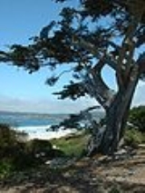
The coastline, including Big Sur
, State Route 1
, and the 17 Mile Drive on the Monterey Peninsula
has made the county world famous. The city of Monterey
was the capital of California under Spanish and Mexican rule. The economy is primarily based upon tourism in the coastal regions, and agriculture in the Salinas River valley
. Most of the county's people live near the northern coast and Salinas valley, while the southern coast and inland mountain regions are almost devoid of human habitation.
in 1874.
The county derived its name from Monterey Bay
. The bay was named by Sebastián Vizcaíno
in 1602 in honor of the Conde de Monterrey (or 'Count of Monterrey), then the Viceroy of New Spain
. Monterrey is a variation of Monterrei
, a municipality in the Galicia region of Spain
from which the Conde de Monterrey and his father (the Fourth Count of Monterrei) were from.
, and roughly similar in population and size to Santa Barbara County.
trains and Greyhound Lines
buses.
Monterey-Salinas Transit provides transit service throughout most of Monterey County, with buses to Big Sur and King City as well as in Monterey, Salinas and Carmel. MST also runs service to San Jose, California
in Santa Clara County
Salinas Municipal Airport is located in the city of Salinas
, and 21,357 (5.1%) from two or more races. Hispanic or Latino of any race were 230,003 persons (55.4%); 50.2% of Monterey County is Mexican, 0.8% Salvadoran, and 0.5% Puerto Rican.
of 2000, there were 401,762 people, 121,236 households, and 87,896 families residing in the county. The population density
was 121 people per square mile (47/km²). There were 131,708 housing units at an average density of 40 per square mile (15/km²). The racial makeup of the county was 55.9% White
, 3.8% Black
or African American
, 1.1% Native American
, 6.0% Asian
, 0.5% Pacific Islander
, 27.8% from other races
, and 5.0% from two or more races. 46.79% of the population were Hispanic
or Latino
of any race. 6.3% were of German and 5.4% English
ancestry according to Census 2000. 52.9% spoke English
, 39.6% Spanish
and 1.6% Tagalog
as their first language.
There were 121,236 households out of which 39.1% had children under the age of 18 living with them, 56.0% were married couples
living together, 11.6% had a female householder with no husband present, and 27.5% were non-families. 21.2% of all households were made up of individuals and 8.2% had someone living alone who was 65 years of age or older. The average household size was 3.14 and the average family size was 3.65.
In the county the population was spread out with 28.4% under the age of 18, 10.9% from 18 to 24, 31.4% from 25 to 44, 19.3% from 45 to 64, and 10.0% who were 65 years of age or older. The median age was 32 years. For every 100 female residents there were 107.3 male residents. For every 100 female residents age 18 and over, there were 107.7 male residents.
The median income for a household in the county was $48,305, and the median income for a family was $51,169. Men had a median income of $38,444 versus $30,036 for women. The per capita income
for the county was $20,165. About 9.7% of families and 13.5% of the population were below the poverty line, including 17.4% of those under age 18 and 6.8% of those age 65 or over.
Monterey County is considered to be a strongly Democratic
county in Presidential
and congressional
elections. The county voted for Al Gore
in 2000
, John Kerry
in 2004
and Barack Obama
in the 2008 election
. The last Republican
to win the county was George H.W. Bush in 1988
.
Monterey is part of California's 17th congressional district
, which is represented by Democrat Sam Farr
. In the State Assembly
, Monterey is part of the 27th and 28th districts, which are held by Democrats Bill Monning
and Anna Caballero
, respectively. Monning was first elected to the Assembly in November 2008; Caballero in November 2006. In the State Senate
, a small part of Monterey is in the 12th district; most of the county is in the 15th. The 12th district is held by Republican Anthony Cannella
and the 15th by Republican Sam Blakeslee
, who is considered to be moderate. Cannella was first elected to the Senate in November 2010; Blakeslee in August 2010.
According to the California Secretary of State, as of April, 2008, Monterey County has 147,066 registered voters. Of those voters, 72,550 (49.3%) are registered Democratic, 42,744 (29.1%) are registered Republican, 5,488 (3.7%) are registered with other political parties, and 26,284 (17.9%) declined to state a political party. Except for Sand City, all of the other cities, towns, and the unincorporated area of Monterey County have more individuals registered with the Democratic Party than the Republican Party. In Sand City, the Republicans have the advantage by 1 voter.
On Nov. 4, 2008 Monterey County voted 51.7 % against Proposition 8 which amended the California Constitution to ban same-sex marriages.
Monterey County is subject to Section 5 of the Voting Rights Act which requires federal preclearance before implementing a change to "any voting qualification or prerequisite to voting."
:
Television service for the community comes from the Monterey-Salinas-Santa Cruz designated market area (DMA). Radio stations Monterey-Salinas-Santa Cruz area of dominant influence (ADI) or continuous measurement market (CMM). Local newspapers include the Monterey County Herald, Monterey County Weekly, Salinas Californian and the Carmel Pine Cone.
of roughly $48,305 and the median home price of $700k has been cause for recent concern over excluding potential home buyers from the market. The end of the United States housing bubble
has caused prices to drop substantially, with median home prices having fallen to $280,000 as at September 2008.
County (United States)
In the United States, a county is a geographic subdivision of a state , usually assigned some governmental authority. The term "county" is used in 48 of the 50 states; Louisiana is divided into parishes and Alaska into boroughs. Parishes and boroughs are called "county-equivalents" by the U.S...
located on the Pacific
Pacific Ocean
The Pacific Ocean is the largest of the Earth's oceanic divisions. It extends from the Arctic in the north to the Southern Ocean in the south, bounded by Asia and Australia in the west, and the Americas in the east.At 165.2 million square kilometres in area, this largest division of the World...
coast of the U.S. state
U.S. state
A U.S. state is any one of the 50 federated states of the United States of America that share sovereignty with the federal government. Because of this shared sovereignty, an American is a citizen both of the federal entity and of his or her state of domicile. Four states use the official title of...
of California
California
California is a state located on the West Coast of the United States. It is by far the most populous U.S. state, and the third-largest by land area...
, its northwestern section forming the southern half of Monterey Bay
Monterey Bay
Monterey Bay is a bay of the Pacific Ocean, along the central coast of California. The bay is south of San Francisco and San Jose, between the cities of Santa Cruz and Monterey....
. The northern half of the bay is in Santa Cruz County
Santa Cruz County, California
Santa Cruz County is a county located on the Pacific coast of the U.S. state of California, on the California Central Coast. The county forms the northern coast of the Monterey Bay. . As of the 2010 U.S. Census, its population was 262,382. The county seat is Santa Cruz...
. As of 2010, the population was 415,057. The county seat
County seat
A county seat is an administrative center, or seat of government, for a county or civil parish. The term is primarily used in the United States....
and largest city is Salinas
Salinas, California
Salinas is the county seat and the largest municipality of Monterey County, California. Salinas is located east-southeast of the mouth of the Salinas River, at an elevation of about 52 feet above sea level. The population was 150,441 at the 2010 census...
. Monterey County is a member of the regional governmental agency, Association of Monterey Bay Area Governments
Association of Monterey Bay Area Governments
The Association of Monterey Bay Area Governments, or AMBAG, is a regional governmental organization which consists of representation of a large number of public agencies within Monterey County, Santa Cruz County and San Benito County, California...
.
The coastline, including Big Sur
Big Sur
Big Sur is a sparsely populated region of the Central Coast of California where the Santa Lucia Mountains rise abruptly from the Pacific Ocean. The name "Big Sur" is derived from the original Spanish-language "el sur grande", meaning "the big south", or from "el país grande del sur", "the big...
, State Route 1
California State Route 1
State Route 1 , more often called Highway 1, is a state highway that runs along much of the Pacific coast of the U.S. state of California. It is famous for running along some of the most beautiful coastlines in the world, leading to its designation as an All-American Road.Highway 1 does not run...
, and the 17 Mile Drive on the Monterey Peninsula
Monterey Peninsula
The Monterey Peninsula is located on the central California coast and comprises the cities of Monterey, Carmel, and Pacific Grove, and unincorporated areas of Monterey County including the resort and community of Pebble Beach.-Monterey:...
has made the county world famous. The city of Monterey
Monterey, California
The City of Monterey in Monterey County is located on Monterey Bay along the Pacific coast in Central California. Monterey lies at an elevation of 26 feet above sea level. As of the 2010 census, the city population was 27,810. Monterey is of historical importance because it was the capital of...
was the capital of California under Spanish and Mexican rule. The economy is primarily based upon tourism in the coastal regions, and agriculture in the Salinas River valley
Salinas River (California)
The Salinas River is the largest river of the central coast of California, running and draining 4,160 square miles. It flows north-northwest and drains the Salinas Valley that slices through the Coast Range south from Monterey Bay...
. Most of the county's people live near the northern coast and Salinas valley, while the southern coast and inland mountain regions are almost devoid of human habitation.
History
Monterey County was one of the original counties of California, created in 1850 at the time of statehood. Parts of the county were given to San Benito CountySan Benito County, California
San Benito County is a county located in the Coast Range Mountains of the U.S. state of California, south of San Jose. As of 2010 the population was 55,269. The county seat is Hollister, which includes nearly two-thirds of the county's population. El Camino Real passes through the county and...
in 1874.
The county derived its name from Monterey Bay
Monterey Bay
Monterey Bay is a bay of the Pacific Ocean, along the central coast of California. The bay is south of San Francisco and San Jose, between the cities of Santa Cruz and Monterey....
. The bay was named by Sebastián Vizcaíno
Sebastián Vizcaíno
Sebastián Vizcaíno was a Spanish soldier, entrepreneur, explorer, and diplomat whose varied roles took him to New Spain, the Philippines, the Baja California peninsula, the California coast and Japan.-Early career:...
in 1602 in honor of the Conde de Monterrey (or 'Count of Monterrey), then the Viceroy of New Spain
New Spain
New Spain, formally called the Viceroyalty of New Spain , was a viceroyalty of the Spanish colonial empire, comprising primarily territories in what was known then as 'América Septentrional' or North America. Its capital was Mexico City, formerly Tenochtitlan, capital of the Aztec Empire...
. Monterrey is a variation of Monterrei
Monterrei
Monterrei is a municipality in Ourense in the Galicia region of north-west Spain....
, a municipality in the Galicia region of Spain
Spain
Spain , officially the Kingdom of Spain languages]] under the European Charter for Regional or Minority Languages. In each of these, Spain's official name is as follows:;;;;;;), is a country and member state of the European Union located in southwestern Europe on the Iberian Peninsula...
from which the Conde de Monterrey and his father (the Fourth Count of Monterrei) were from.
Geography
According to the 2000 census, the county has a total area of 3771.07 square miles (9,767 km²), of which 3321.95 square miles (8,603.8 km²) (or 88.09%) is land and 449.12 square miles (1,163.2 km²) (or 11.91%) is water. The county is roughly 1.5 times larger than the state of DelawareDelaware
Delaware is a U.S. state located on the Atlantic Coast in the Mid-Atlantic region of the United States. It is bordered to the south and west by Maryland, and to the north by Pennsylvania...
, and roughly similar in population and size to Santa Barbara County.
Cities and towns
- Carmel-by-the-SeaCarmel-by-the-Sea, CaliforniaCarmel-by-the-Sea, often called simply Carmel, is a small city in Monterey County, California, United States, founded in 1902 and incorporated in 1916. Situated on the Monterey Peninsula, the town is known for its natural scenery and rich artistic history...
- Del Rey OaksDel Rey Oaks, CaliforniaDel Rey Oaks is a city in Monterey County, California, United States. Del Rey Oaks is located just southeast of Seaside, at an elevation of 82 feet . The population was 1,650 at the 2000 census...
- GonzalesGonzales, CaliforniaGonzales is a city in Monterey County, California, United States. Gonzales is located southeast of Salinas, at an elevation of 135 feet . The population was 8,187 at the 2010 census, up from 7,525 at the 2000 census. Gonzales is a member of the Association of Monterey Bay Area...
- GreenfieldGreenfield, CaliforniaGreenfield is a city in Monterey County, California, United States. Greenfield is located southeast of Salinas, at an elevation of 289 feet . The city was the fastest growing in the county during the 2000s, the population was 12,583 in 2000, increasing to 16,330 in the 2010 census. Its most...
- King CityKing City, CaliforniaKing City is a city in Monterey County, California, United States. King City is located on the Salinas River southeast of Salinas, at an elevation of 335 feet . It lies along U.S. Route 101 in the Salinas Valley of the Central Coast of California. King City is a member of the Association of...
- MarinaMarina, CaliforniaMarina is a city in Monterey County, California, United States. The population was 19,718 at the 2010 census. Marina is located along the central coast of California, west of Salinas, and 8 miles north of Monterey, at an elevation of 43 feet . Marina was incorporated in 1975 and is the newest city...
- MontereyMonterey, CaliforniaThe City of Monterey in Monterey County is located on Monterey Bay along the Pacific coast in Central California. Monterey lies at an elevation of 26 feet above sea level. As of the 2010 census, the city population was 27,810. Monterey is of historical importance because it was the capital of...
- Pacific GrovePacific Grove, CaliforniaPacific Grove is a coastal city in Monterey County, California, USA, with a population of 15,041 as of the 2010 census, down from 15,522 as of the 2000 census...
- SalinasSalinas, CaliforniaSalinas is the county seat and the largest municipality of Monterey County, California. Salinas is located east-southeast of the mouth of the Salinas River, at an elevation of about 52 feet above sea level. The population was 150,441 at the 2010 census...
- Sand CitySand City, CaliforniaSand City is a city in Monterey County, California, United States, located on the shores of Monterey Bay, and surrounded on most sides by the larger city of Seaside. Sand City is located northeast of Monterey, at an elevation of 72 feet . The population was 334 at the 2010 census, up from 261 at...
- SeasideSeaside, CaliforniaSeaside is a city in Monterey County, California, United States, with a population of 33,025 as of the 2010 census. Seaside is located east-northeast of Monterey, at an elevation of 33 feet...
- SoledadSoledad, CaliforniaSoledad, meaning "solitude" and "loneliness" in Spanish, is a city in Monterey County, California, United States. Soledad is located southeast of Salinas, at an elevation of 190 feet...
Census-designated places
- AromasAromas, CaliforniaAromas is a census-designated place in Monterey County, and San Benito County, California, United States. The CDP straddles the border of the two counties, with Monterey County to the west and San Benito County to the east. The Santa Cruz County line is less than a mile to the Northwest, and...
- BorondaBoronda, CaliforniaBoronda is a census-designated place in Monterey County, California, United States. The population was 1,710 at the 2010 census, up from 1,325 at the 2000 census.-Geography:Boronda is located at ....
- BradleyBradley, CaliforniaBradley is a census-designated place in Monterey County, California, United States. Bradley is located on the Salinas River south-southeast of San Ardo, at an elevation of 548 feet...
- Carmel Valley VillageCarmel Valley Village, CaliforniaCarmel Valley Village is a census-designated place in Monterey County, California, United States. At the time of the 2010 census the population was 4,407, down from 4,700 at the 2000 census. In November 2009, a majority of residents voted against incorporation.-Geography and ecology:Carmel Valley...
- CastrovilleCastroville, CaliforniaCastroville is a census-designated place in Monterey County, California, United States. Castroville is located northwest of Salinas, at an elevation of 23 feet . The population was 6,481 at the 2010 census, down from 6,724 at the 2000 census. Castroville calls itself "Artichoke Center of the...
- ChualarChualar, CaliforniaChualar is a census-designated place in Monterey County, California, United States. Chualar is located southeast of Salinas, at an elevation of 115 feet...
- Del Monte ForestDel Monte Forest, CaliforniaDel Monte Forest is a census-designated place located in Monterey County, California. As of the 2010 census, the CDP had a total population of 4,514, down from 4,532 at the 2000 census. The census area includes the separate well-known community of Pebble Beach...
, includes the well-known community of Pebble BeachPebble Beach, CaliforniaPebble Beach is an unincorporated community in Monterey County, California. It lies at an elevation of 3 feet . Pebble Beach is a small coastal resort destination, home to the famous golf course, Pebble Beach Golf Links.... - ElkhornElkhorn, CaliforniaElkhorn is a census-designated place in Monterey County, California, United States. Elkhorn was a stop on the Southern Pacific Railroad northwest of Prunedale, at an elevation of 10 feet . The population of Elkhorn was 1,565 at the 2010 census, down from 1,591 at the 2000 census. Elkhorn was...
- Las LomasLas Lomas, CaliforniaLas Lomas is a census-designated place in Monterey County, California, United States. Las Lomas is located north-northwest of Prunedale, at an elevation of 43 feet...
- LockwoodLockwood, CaliforniaLockwood is a census-designated place in Monterey County, California. It is located east-southeast of Jolon, 1.8 miles north of the mouth of Tule Canyon, 3 miles north of San Antonio River, and 9.3 miles north of Bryson, at an elevation of 971 feet .Lockwood is in southern Monterey County and...
- Moss LandingMoss Landing, CaliforniaMoss Landing is a census-designated place in Monterey County, California, United States. Moss Landing is located on the Pajaro Valley Consolidated Railroad north-northeast of Monterey, at an elevation of 10 feet . As of the 2010 census, the CDP population was 204, down from 300 at the 2000...
- PajaroPajaro, CaliforniaPajaro is a census-designated place in Monterey County, California, United States. Pajaro is located on the south bank of the Pajaro River northeast of its mouth, at an elevation of 26 feet . The population was 3,070 at the 2010 census, down from 3,384 at the 2000 census...
- PrunedalePrunedale, CaliforniaPrunedale is a census-designated place in Monterey County, California, United States. Prunedale is located north of Salinas, at an elevation of 92 feet . The population was 17,560 residents at the time of the 2010 census, up from 16,432 at the 2000 census...
- San ArdoSan Ardo, CaliforniaSan Ardo is a census-designated place in Monterey County, California, United States. San Ardo is located southeast of King City, at an elevation of 449 feet...
- San LucasSan Lucas, CaliforniaSan Lucas is a census-designated place in Monterey County, California, United States. San Lucas is located on the Salinas River southeast of King City, at an elevation of 410 feet...
- SpreckelsSpreckels, CaliforniaSpreckels is a census-designated place located in the Salinas Valley of Monterey County, California, United States. Spreckels is located south of Salinas, at an elevation of 62 feet . The population was 673 at the 2010 census, up from 485 at the 2000 census.Spreckels is one of the best-preserved...
Other unincorporated communities
- Carmel HighlandsCarmel Highlands, CaliforniaCarmel Highlands is an unincorporated community in Monterey County, California, United States. It is located south of Carmel-by-the-Sea , at an elevation of 318 feet . Carmel Highlands is located between Carmel to the north, and Big Sur to the south, and is close to Point Lobos State Reserve...
- JolonJolon, CaliforniaJolon is an unincorporated community in Monterey County, California. It is located south of King City, at an elevation of 971 feet . Jolon is located in the Salinas Valley in a rural area located about 6 miles from Mission San Antonio de Padua, and is part of Fort Hunter Liggett.The town was...
- ParkfieldParkfield, CaliforniaParkfield is an unincorporated community in Monterey County, California. It is located on Little Cholame Creek east of Bradley, at an elevation of 1529 feet...
Other locales
- Big SurBig SurBig Sur is a sparsely populated region of the Central Coast of California where the Santa Lucia Mountains rise abruptly from the Pacific Ocean. The name "Big Sur" is derived from the original Spanish-language "el sur grande", meaning "the big south", or from "el país grande del sur", "the big...
includes the areas of Lucia, CaliforniaLucia, CaliforniaLucia is an unincorporated community in Monterey County, California. It is located east of Lopez Point, at an elevation of 354 feet . Lucia is one of the three small settlements of restaurants, and motels located along State Route 1 on the Big Sur coast...
and Gorda, CaliforniaGorda, CaliforniaGorda is an unincorporated community in Monterey County, California. It is located north of Cape San Martin, at an elevation of 148 feet . It is one of the three small settlements of gas stations, restaurants, and motels located along State Route 1 on the Big Sur coast... - Laguna Seca RanchLaguna Seca RanchLaguna Seca Ranch is a historic agricultural property in western Monterey County, California, United States.-Geography and drainage:...
- Fort OrdFort OrdFort Ord was a U.S. Army post on Monterey Bay in California. It was established in 1917 as a maneuver area and field artillery target range and was closed in September 1994. Fort Ord was one of the most attractive locations of any U.S. Army post, because of its proximity to the beach and California...
decommissioned in the 1990s, some of it was converted to California State University, Monterey BayCalifornia State University, Monterey BayCalifornia State University, Monterey Bay is a small public university in the California State University system on the site of the former U.S. Army base Fort Ord, on the Central Coast of California. It is accredited by the Western Association of Schools and Colleges.CSUMB was founded in 1994 with... - Naval Postgraduate SchoolNaval Postgraduate SchoolThe Naval Postgraduate School is an accredited research university operated by the United States Navy. Located in Monterey, California, it grants master's degrees, Engineer's degrees and doctoral degrees...
- Fort Hunter LiggettFort Hunter LiggettFort Hunter Liggett , named after General Hunter Liggett in 1941, is a United States Army fort in southern Monterey County, California, about 250 miles north of Los Angeles and south of San Francisco...
- Presidio of Monterey, home to the Defense Language InstituteDefense Language InstituteThe Defense Language Institute is a United States Department of Defense educational and research institution, which provides linguistic and cultural instruction to the Department of Defense, other Federal Agencies and numerous and varied other customers...
and one of three presidioPresidioA presidio is a fortified base established by the Spanish in North America between the sixteenth and nineteenth centuries. The fortresses were built to protect against pirates, hostile native Americans and enemy colonists. Other presidios were held by Spain in the sixteenth and seventeenth...
s in California - Jacks Peak ParkJacks Peak ParkJacks Peak Park is a county park in Monterey County, California. Its central feature is Jacks Peak, the highest point on the Monterey Peninsula, rising 1,068 feet above Monterey and Carmel. The park encompasses 525 acres under control of the Monterey County Parks Department.-History:The park is...
, including the highest point on the Monterey PeninsulaMonterey PeninsulaThe Monterey Peninsula is located on the central California coast and comprises the cities of Monterey, Carmel, and Pacific Grove, and unincorporated areas of Monterey County including the resort and community of Pebble Beach.-Monterey:...
Adjacent counties
National protected areas
- Los Padres National ForestLos Padres National ForestLos Padres National Forest is a forest located in southern and central California, which includes most of the mountainous land along the California coast from Ventura to Monterey, extending inland...
(part) - Pinnacles National MonumentPinnacles National MonumentPinnacles National Monument is a protected mountainous area located east of central California's Salinas Valley, just miles from the town of Soledad...
(part) - Salinas River National Wildlife RefugeSalinas River National Wildlife RefugeSalinas River National Wildlife Refuge is located approximately 11 miles north of Monterey, California and 3 miles south of Castroville, California at the point where the Salinas River empties into Monterey Bay. The 367 acre refuge encompasses several habitat types including sand dunes, pickleweed...
- Ventana WildernessVentana WildernessThe Ventana Wilderness of Los Padres National Forest is a Federally designated wilderness area located in the Santa Lucia Mountains along the Central Coast of California. This wilderness was established in 1969 when the Ventana Wilderness Act abolished the Ventana Primitive Area and replaced it...
(part)
Marine protected areas
- Soquel Canyon State Marine Conservation Area
- Elkhorn Slough State Marine Reserve
- Elkhorn Slough State Marine Conservation Area
- Moro Cojo Slough State Marine ReserveMoro Cojo Slough State Marine ReserveMoro Cojo Estuary State Marine Reserve is a marine protected area established to protect the wildlife and habitats in Moro Cojo Slough. Moro Cojo Slough is located inland from Monterey Bay on the central coast of California, directly south of the more widely known Elkhorn Slough. The area covers...
- Portuguese Ledge State Marine Conservation Area
- Pacific Grove Marine Gardens State Marine Conservation Area
- Lovers Point State Marine ReserveLovers Point State Marine ReserveLovers Point State Marine Reserve is one of four small marine protected areas located near the cities of Monterey and Pacific Grove, at the southern end of Monterey Bay on California’s central coast. The four MPAs together encompass . The SMR protects all marine life within its boundaries...
- Edward F. Ricketts State Marine Conservation AreaEdward F. Ricketts State Marine Conservation AreaEdward F. Ricketts State Marine Conservation Area and Pacific Grove Marine Gardens State Marine Conservation Area are two of four small marine protected areas located near the cities of Monterey and Pacific Grove, at the southern end of Monterey Bay on California’s central coast. The four areas...
- Asilomar State Marine ReserveAsilomar State Marine ReserveAsilomar State Marine Reserve is one of four small marine protected areas located near the cities of Monterey and Pacific Grove, at the southern end of Monterey Bay on California’s central coast. The four MPAs together encompass . The SMR protects all marine life within its boundaries...
Major highways
- U.S. Route 101
.svg.png)
- State Route 1
 California State Route 1State Route 1 , more often called Highway 1, is a state highway that runs along much of the Pacific coast of the U.S. state of California. It is famous for running along some of the most beautiful coastlines in the world, leading to its designation as an All-American Road.Highway 1 does not run...
 - State Route 68
 California State Route 68State Route 68 is a state highway that runs from Pacific Grove to Salinas in Monterey County. It is about long.-Route description:This route is part of the California Freeway and Expressway System and is eligible for the State Scenic Highway System. However, only the part from SR 1 to the Salinas...
 - State Route 146
 California State Route 146State Route 146 is a state highway in the U.S. state of California in Monterey and San Benito Counties. The route serves as an entryway to the Pinnacles National Monument, located in the Gabilan Mountains, from both the Salinas Valley on the west and State Route 25 on the east.This route is...
 - State Route 156
 California State Route 156State Route 156 is a state highway in California, USA, running from Castroville to State Route 152 near Hollister.This route is eligible for the State Scenic Highway System.-Route description:...
 - State Route 183

- State Route 198
 California State Route 198State Route 198 is an east–west state highway that connects the California Central Coast to the mid-Central Valley at Visalia, although the most-traveled portion is in the Central Valley itself....
Public transportation
Monterey County is served by AmtrakAmtrak
The National Railroad Passenger Corporation, doing business as Amtrak , is a government-owned corporation that was organized on May 1, 1971, to provide intercity passenger train service in the United States. "Amtrak" is a portmanteau of the words "America" and "track". It is headquartered at Union...
trains and Greyhound Lines
Greyhound
The Greyhound is a breed of sighthound that has been primarily bred for coursing game and racing, and the breed has also recently seen a resurgence in its popularity as a pedigree show dog and family pet. It is a gentle and intelligent breed...
buses.
Monterey-Salinas Transit provides transit service throughout most of Monterey County, with buses to Big Sur and King City as well as in Monterey, Salinas and Carmel. MST also runs service to San Jose, California
San Jose, California
San Jose is the third-largest city in California, the tenth-largest in the U.S., and the county seat of Santa Clara County which is located at the southern end of San Francisco Bay...
in Santa Clara County
Airports
- Monterey Peninsula AirportMonterey Peninsula AirportMonterey Peninsula Airport is a regional airport located three miles southeast of the central business district of Monterey, a city in Monterey County, California, USA. It was created in 1936....
is located just east of the City of Monterey. Commercial flights are available. - Marina Municipal AirportMarina Municipal AirportMarina Municipal Airport is a public airport located two miles east of the central business district of Marina, a city in Monterey County, California, United States...
is located in the city of MarinaMarinaA marina is a dock or basin with moorings and supplies for yachts and small boats.A marina differs from a port in that a marina does not handle large passenger ships or cargo from freighters....
.
Salinas Municipal Airport is located in the city of Salinas
2010
The 2010 United States Census reported that Monterey County had a population of 415,057. The racial makeup of Monterey County was 230,717 (55.6%) White, 12,785 (3.1%) African American, 5,464 (1.3%) Native American, 25,258 (6.1%) Asian (2.8% Filipino, 0.7% Korean, 0.6% Chinese, 0.6% Japanese, 0.4% Vietnamese, 0.4% Indian), 2,071 (0.5%) Pacific Islander, 117,405 (28.3%) from other racesRace (United States Census)
Race and ethnicity in the United States Census, as defined by the Federal Office of Management and Budget and the United States Census Bureau, are self-identification data items in which residents choose the race or races with which they most closely identify, and indicate whether or not they are...
, and 21,357 (5.1%) from two or more races. Hispanic or Latino of any race were 230,003 persons (55.4%); 50.2% of Monterey County is Mexican, 0.8% Salvadoran, and 0.5% Puerto Rican.
| Population reported at 2010 United States Census | |||||||||
|---|---|---|---|---|---|---|---|---|---|
Population |
American |
American |
|
Islander |
races Race (United States Census) Race and ethnicity in the United States Census, as defined by the Federal Office of Management and Budget and the United States Census Bureau, are self-identification data items in which residents choose the race or races with which they most closely identify, and indicate whether or not they are... |
more races |
or Latino (of any race) |
||
| Monterey County | 415,057 | 230,717 | 12,785 | 5,464 | 25,258 | 2,071 | 117,405 | 21,357 | 230,003 |
city |
Population |
American |
American |
|
Islander |
races Race (United States Census) Race and ethnicity in the United States Census, as defined by the Federal Office of Management and Budget and the United States Census Bureau, are self-identification data items in which residents choose the race or races with which they most closely identify, and indicate whether or not they are... |
more races |
or Latino (of any race) |
|
| Carmel-by-the-Sea Carmel-by-the-Sea, California Carmel-by-the-Sea, often called simply Carmel, is a small city in Monterey County, California, United States, founded in 1902 and incorporated in 1916. Situated on the Monterey Peninsula, the town is known for its natural scenery and rich artistic history... |
3,722 | 3,464 | 11 | 8 | 111 | 6 | 45 | 77 | 174 |
| Del Rey Oaks Del Rey Oaks, California Del Rey Oaks is a city in Monterey County, California, United States. Del Rey Oaks is located just southeast of Seaside, at an elevation of 82 feet . The population was 1,650 at the 2000 census... |
1,624 | 1,326 | 16 | 12 | 128 | 4 | 52 | 86 | 169 |
| Gonzales Gonzales, California Gonzales is a city in Monterey County, California, United States. Gonzales is located southeast of Salinas, at an elevation of 135 feet . The population was 8,187 at the 2010 census, up from 7,525 at the 2000 census. Gonzales is a member of the Association of Monterey Bay Area... |
8,187 | 3,464 | 81 | 124 | 190 | 14 | 3,958 | 356 | 7,276 |
| Greenfield Greenfield, California Greenfield is a city in Monterey County, California, United States. Greenfield is located southeast of Salinas, at an elevation of 289 feet . The city was the fastest growing in the county during the 2000s, the population was 12,583 in 2000, increasing to 16,330 in the 2010 census. Its most... |
16,330 | 5,976 | 183 | 878 | 179 | 13 | 8,453 | 648 | 14,917 |
| King City King City, California King City is a city in Monterey County, California, United States. King City is located on the Salinas River southeast of Salinas, at an elevation of 335 feet . It lies along U.S. Route 101 in the Salinas Valley of the Central Coast of California. King City is a member of the Association of... |
12,874 | 6,173 | 150 | 347 | 172 | 8 | 5,451 | 573 | 11,266 |
| Marina Marina, California Marina is a city in Monterey County, California, United States. The population was 19,718 at the 2010 census. Marina is located along the central coast of California, west of Salinas, and 8 miles north of Monterey, at an elevation of 43 feet . Marina was incorporated in 1975 and is the newest city... |
19,718 | 8,904 | 1,487 | 140 | 3,931 | 544 | 2,738 | 1,974 | 5,372 |
| Monterey Monterey, California The City of Monterey in Monterey County is located on Monterey Bay along the Pacific coast in Central California. Monterey lies at an elevation of 26 feet above sea level. As of the 2010 census, the city population was 27,810. Monterey is of historical importance because it was the capital of... |
27,810 | 21,788 | 777 | 149 | 2,204 | 91 | 1,382 | 1,419 | 3,817 |
| Pacific Grove Pacific Grove, California Pacific Grove is a coastal city in Monterey County, California, USA, with a population of 15,041 as of the 2010 census, down from 15,522 as of the 2000 census... |
15,041 | 12,710 | 199 | 78 | 872 | 49 | 469 | 664 | 1,615 |
| Salinas Salinas, California Salinas is the county seat and the largest municipality of Monterey County, California. Salinas is located east-southeast of the mouth of the Salinas River, at an elevation of about 52 feet above sea level. The population was 150,441 at the 2010 census... |
150,441 | 68,973 | 2,993 | 1,888 | 9,438 | 478 | 59,041 | 7,630 | 112,799 |
| Sand City Sand City, California Sand City is a city in Monterey County, California, United States, located on the shores of Monterey Bay, and surrounded on most sides by the larger city of Seaside. Sand City is located northeast of Monterey, at an elevation of 72 feet . The population was 334 at the 2010 census, up from 261 at... |
334 | 223 | 13 | 3 | 16 | 1 | 61 | 17 | 123 |
| Seaside Seaside, California Seaside is a city in Monterey County, California, United States, with a population of 33,025 as of the 2010 census. Seaside is located east-northeast of Monterey, at an elevation of 33 feet... |
33,025 | 15,978 | 2,783 | 347 | 3,206 | 529 | 7,579 | 2,603 | 14,347 |
| Soledad Soledad, California Soledad, meaning "solitude" and "loneliness" in Spanish, is a city in Monterey County, California, United States. Soledad is located southeast of Salinas, at an elevation of 190 feet... |
25,738 | 12,625 | 2,945 | 367 | 757 | 103 | 8,189 | 752 | 18,308 |
place Census-designated place A census-designated place is a concentration of population identified by the United States Census Bureau for statistical purposes. CDPs are delineated for each decennial census as the statistical counterparts of incorporated places such as cities, towns and villages... |
Population |
American |
American |
|
Islander |
races Race (United States Census) Race and ethnicity in the United States Census, as defined by the Federal Office of Management and Budget and the United States Census Bureau, are self-identification data items in which residents choose the race or races with which they most closely identify, and indicate whether or not they are... |
more races |
or Latino (of any race) |
|
| Aromas Aromas, California Aromas is a census-designated place in Monterey County, and San Benito County, California, United States. The CDP straddles the border of the two counties, with Monterey County to the west and San Benito County to the east. The Santa Cruz County line is less than a mile to the Northwest, and... ‡ |
1,358 | 1,026 | 7 | 24 | 35 | 1 | 194 | 71 | 511 |
| Boronda Boronda, California Boronda is a census-designated place in Monterey County, California, United States. The population was 1,710 at the 2010 census, up from 1,325 at the 2000 census.-Geography:Boronda is located at .... |
1,710 | 661 | 10 | 26 | 116 | 7 | 774 | 116 | 1,457 |
| Bradley Bradley, California Bradley is a census-designated place in Monterey County, California, United States. Bradley is located on the Salinas River south-southeast of San Ardo, at an elevation of 548 feet... |
93 | 85 | 0 | 2 | 0 | 0 | 5 | 1 | 11 |
| Carmel Valley Village Carmel Valley Village, California Carmel Valley Village is a census-designated place in Monterey County, California, United States. At the time of the 2010 census the population was 4,407, down from 4,700 at the 2000 census. In November 2009, a majority of residents voted against incorporation.-Geography and ecology:Carmel Valley... |
4,407 | 4,044 | 21 | 22 | 70 | 11 | 120 | 119 | 328 |
| Castroville Castroville, California Castroville is a census-designated place in Monterey County, California, United States. Castroville is located northwest of Salinas, at an elevation of 23 feet . The population was 6,481 at the 2010 census, down from 6,724 at the 2000 census. Castroville calls itself "Artichoke Center of the... |
6,481 | 2,807 | 96 | 96 | 169 | 9 | 2,955 | 349 | 5,841 |
| Chualar Chualar, California Chualar is a census-designated place in Monterey County, California, United States. Chualar is located southeast of Salinas, at an elevation of 115 feet... |
1,190 | 337 | 1 | 2 | 11 | 0 | 827 | 12 | 1,151 |
| Del Monte Forest Del Monte Forest, California Del Monte Forest is a census-designated place located in Monterey County, California. As of the 2010 census, the CDP had a total population of 4,514, down from 4,532 at the 2000 census. The census area includes the separate well-known community of Pebble Beach... |
4,514 | 3,922 | 43 | 10 | 388 | 3 | 57 | 91 | 167 |
| Elkhorn Elkhorn, California Elkhorn is a census-designated place in Monterey County, California, United States. Elkhorn was a stop on the Southern Pacific Railroad northwest of Prunedale, at an elevation of 10 feet . The population of Elkhorn was 1,565 at the 2010 census, down from 1,591 at the 2000 census. Elkhorn was... |
1,565 | 1,122 | 9 | 7 | 63 | 3 | 286 | 75 | 588 |
| Las Lomas Las Lomas, California Las Lomas is a census-designated place in Monterey County, California, United States. Las Lomas is located north-northwest of Prunedale, at an elevation of 43 feet... |
3,024 | 1,167 | 37 | 93 | 53 | 24 | 1,490 | 160 | 2,696 |
| Lockwood Lockwood, California Lockwood is a census-designated place in Monterey County, California. It is located east-southeast of Jolon, 1.8 miles north of the mouth of Tule Canyon, 3 miles north of San Antonio River, and 9.3 miles north of Bryson, at an elevation of 971 feet .Lockwood is in southern Monterey County and... |
379 | 297 | 4 | 6 | 2 | 0 | 56 | 14 | 100 |
| Moss Landing Moss Landing, California Moss Landing is a census-designated place in Monterey County, California, United States. Moss Landing is located on the Pajaro Valley Consolidated Railroad north-northeast of Monterey, at an elevation of 10 feet . As of the 2010 census, the CDP population was 204, down from 300 at the 2000... |
204 | 149 | 7 | 1 | 2 | 1 | 30 | 14 | 46 |
| Pajaro Pajaro, California Pajaro is a census-designated place in Monterey County, California, United States. Pajaro is located on the south bank of the Pajaro River northeast of its mouth, at an elevation of 26 feet . The population was 3,070 at the 2010 census, down from 3,384 at the 2000 census... |
3,070 | 1,451 | 15 | 78 | 53 | 0 | 1,281 | 192 | 2,889 |
| Pine Canyon Pine Canyon, California Pine Canyon is a census-designated place in Monterey County, California, just south of King City. Pine Canyon sits at an elevation of . The 2010 United States census reported Pine Canyon's population was 1,822.-Geography:... |
1,822 | 1,173 | 29 | 15 | 18 | 0 | 490 | 97 | 984 |
| Prunedale Prunedale, California Prunedale is a census-designated place in Monterey County, California, United States. Prunedale is located north of Salinas, at an elevation of 92 feet . The population was 17,560 residents at the time of the 2010 census, up from 16,432 at the 2000 census... |
17,560 | 11,771 | 177 | 199 | 672 | 58 | 3,639 | 1,044 | 7,322 |
| San Ardo San Ardo, California San Ardo is a census-designated place in Monterey County, California, United States. San Ardo is located southeast of King City, at an elevation of 449 feet... |
517 | 252 | 1 | 3 | 5 | 0 | 245 | 11 | 363 |
| San Lucas San Lucas, California San Lucas is a census-designated place in Monterey County, California, United States. San Lucas is located on the Salinas River southeast of King City, at an elevation of 410 feet... |
269 | 113 | 0 | 4 | 6 | 0 | 127 | 19 | 224 |
| Spreckels Spreckels, California Spreckels is a census-designated place located in the Salinas Valley of Monterey County, California, United States. Spreckels is located south of Salinas, at an elevation of 62 feet . The population was 673 at the 2010 census, up from 485 at the 2000 census.Spreckels is one of the best-preserved... |
673 | 483 | 0 | 13 | 26 | 0 | 130 | 21 | 193 |
communities Unincorporated area In law, an unincorporated area is a region of land that is not a part of any municipality.To "incorporate" in this context means to form a municipal corporation, a city, town, or village with its own government. An unincorporated community is usually not subject to or taxed by a municipal government... |
Population |
American |
American |
|
Islander |
races Race (United States Census) Race and ethnicity in the United States Census, as defined by the Federal Office of Management and Budget and the United States Census Bureau, are self-identification data items in which residents choose the race or races with which they most closely identify, and indicate whether or not they are... |
more races |
or Latino (of any race) |
|
| All others not CDPs (combined) | 51,377 | 38,253 | 690 | 522 | 2,365 | 114 | 7,281 | 2,152 | 14,949 |
| ‡ Note: these numbers reflect only the portion of this CDP in Monterey County | |||||||||
2000
As of the censusCensus
A census is the procedure of systematically acquiring and recording information about the members of a given population. It is a regularly occurring and official count of a particular population. The term is used mostly in connection with national population and housing censuses; other common...
of 2000, there were 401,762 people, 121,236 households, and 87,896 families residing in the county. The population density
Population density
Population density is a measurement of population per unit area or unit volume. It is frequently applied to living organisms, and particularly to humans...
was 121 people per square mile (47/km²). There were 131,708 housing units at an average density of 40 per square mile (15/km²). The racial makeup of the county was 55.9% White
Race (United States Census)
Race and ethnicity in the United States Census, as defined by the Federal Office of Management and Budget and the United States Census Bureau, are self-identification data items in which residents choose the race or races with which they most closely identify, and indicate whether or not they are...
, 3.8% Black
Race (United States Census)
Race and ethnicity in the United States Census, as defined by the Federal Office of Management and Budget and the United States Census Bureau, are self-identification data items in which residents choose the race or races with which they most closely identify, and indicate whether or not they are...
or African American
Race (United States Census)
Race and ethnicity in the United States Census, as defined by the Federal Office of Management and Budget and the United States Census Bureau, are self-identification data items in which residents choose the race or races with which they most closely identify, and indicate whether or not they are...
, 1.1% Native American
Race (United States Census)
Race and ethnicity in the United States Census, as defined by the Federal Office of Management and Budget and the United States Census Bureau, are self-identification data items in which residents choose the race or races with which they most closely identify, and indicate whether or not they are...
, 6.0% Asian
Race (United States Census)
Race and ethnicity in the United States Census, as defined by the Federal Office of Management and Budget and the United States Census Bureau, are self-identification data items in which residents choose the race or races with which they most closely identify, and indicate whether or not they are...
, 0.5% Pacific Islander
Race (United States Census)
Race and ethnicity in the United States Census, as defined by the Federal Office of Management and Budget and the United States Census Bureau, are self-identification data items in which residents choose the race or races with which they most closely identify, and indicate whether or not they are...
, 27.8% from other races
Race (United States Census)
Race and ethnicity in the United States Census, as defined by the Federal Office of Management and Budget and the United States Census Bureau, are self-identification data items in which residents choose the race or races with which they most closely identify, and indicate whether or not they are...
, and 5.0% from two or more races. 46.79% of the population were Hispanic
Race (United States Census)
Race and ethnicity in the United States Census, as defined by the Federal Office of Management and Budget and the United States Census Bureau, are self-identification data items in which residents choose the race or races with which they most closely identify, and indicate whether or not they are...
or Latino
Race (United States Census)
Race and ethnicity in the United States Census, as defined by the Federal Office of Management and Budget and the United States Census Bureau, are self-identification data items in which residents choose the race or races with which they most closely identify, and indicate whether or not they are...
of any race. 6.3% were of German and 5.4% English
English people
The English are a nation and ethnic group native to England, who speak English. The English identity is of early mediaeval origin, when they were known in Old English as the Anglecynn. England is now a country of the United Kingdom, and the majority of English people in England are British Citizens...
ancestry according to Census 2000. 52.9% spoke English
English language
English is a West Germanic language that arose in the Anglo-Saxon kingdoms of England and spread into what was to become south-east Scotland under the influence of the Anglian medieval kingdom of Northumbria...
, 39.6% Spanish
Spanish language
Spanish , also known as Castilian , is a Romance language in the Ibero-Romance group that evolved from several languages and dialects in central-northern Iberia around the 9th century and gradually spread with the expansion of the Kingdom of Castile into central and southern Iberia during the...
and 1.6% Tagalog
Tagalog language
Tagalog is an Austronesian language spoken as a first language by a third of the population of the Philippines and as a second language by most of the rest. It is the first language of the Philippine region IV and of Metro Manila...
as their first language.
There were 121,236 households out of which 39.1% had children under the age of 18 living with them, 56.0% were married couples
Marriage
Marriage is a social union or legal contract between people that creates kinship. It is an institution in which interpersonal relationships, usually intimate and sexual, are acknowledged in a variety of ways, depending on the culture or subculture in which it is found...
living together, 11.6% had a female householder with no husband present, and 27.5% were non-families. 21.2% of all households were made up of individuals and 8.2% had someone living alone who was 65 years of age or older. The average household size was 3.14 and the average family size was 3.65.
In the county the population was spread out with 28.4% under the age of 18, 10.9% from 18 to 24, 31.4% from 25 to 44, 19.3% from 45 to 64, and 10.0% who were 65 years of age or older. The median age was 32 years. For every 100 female residents there were 107.3 male residents. For every 100 female residents age 18 and over, there were 107.7 male residents.
The median income for a household in the county was $48,305, and the median income for a family was $51,169. Men had a median income of $38,444 versus $30,036 for women. The per capita income
Per capita income
Per capita income or income per person is a measure of mean income within an economic aggregate, such as a country or city. It is calculated by taking a measure of all sources of income in the aggregate and dividing it by the total population...
for the county was $20,165. About 9.7% of families and 13.5% of the population were below the poverty line, including 17.4% of those under age 18 and 6.8% of those age 65 or over.
Politics
| Year | GOP Republican Party (United States) The Republican Party is one of the two major contemporary political parties in the United States, along with the Democratic Party. Founded by anti-slavery expansion activists in 1854, it is often called the GOP . The party's platform generally reflects American conservatism in the U.S... |
DEM Democratic Party (United States) The Democratic Party is one of two major contemporary political parties in the United States, along with the Republican Party. The party's socially liberal and progressive platform is largely considered center-left in the U.S. political spectrum. The party has the lengthiest record of continuous... |
Others |
|---|---|---|---|
| 2008 United States presidential election, 2008 The United States presidential election of 2008 was the 56th quadrennial presidential election. It was held on November 4, 2008. Democrat Barack Obama, then the junior United States Senator from Illinois, defeated Republican John McCain, the senior U.S. Senator from Arizona. Obama received 365... |
68.2% 88,453 | 2.0% 2,533 | |
| 2004 United States presidential election, 2004 The United States presidential election of 2004 was the United States' 55th quadrennial presidential election. It was held on Tuesday, November 2, 2004. Republican Party candidate and incumbent President George W. Bush defeated Democratic Party candidate John Kerry, the then-junior U.S. Senator... |
60.4% 75,241 | 1.3% 1,574 | |
| 2000 United States presidential election, 2000 The United States presidential election of 2000 was a contest between Republican candidate George W. Bush, then-governor of Texas and son of former president George H. W. Bush , and Democratic candidate Al Gore, then-Vice President.... |
57.5% 67,618 | 5.2% 6,155 | |
| 1996 United States presidential election, 1996 The United States presidential election of 1996 was a contest between the Democratic national ticket of President Bill Clinton of Arkansas and Vice President Al Gore of Tennessee and the Republican national ticket of former Senator Bob Dole of Kansas for President and former Housing Secretary Jack... |
53.2% 57,700 | 10.2% 11,064 | |
| 1992 United States presidential election, 1992 The United States presidential election of 1992 had three major candidates: Incumbent Republican President George Bush; Democratic Arkansas Governor Bill Clinton, and independent Texas businessman Ross Perot.... |
47.0% 54,861 | 21.7% 25,367 | |
| 1988 United States presidential election, 1988 The United States presidential election of 1988 featured no incumbent president, as President Ronald Reagan was unable to seek re-election after serving the maximum two terms allowed by the Twenty-second Amendment. Reagan's Vice President, George H. W. Bush, won the Republican nomination, while the... |
48.8% 48,998 | 1.4% 1,361 | |
| 1984 United States presidential election, 1984 The United States presidential election of 1984 was a contest between the incumbent President Ronald Reagan, the Republican candidate, and former Vice President Walter Mondale, the Democratic candidate. Reagan was helped by a strong economic recovery from the deep recession of 1981–1982... |
41.8% 40,733 | 1.1% 1,027 | |
| 1980 United States presidential election, 1980 The United States presidential election of 1980 featured a contest between incumbent Democrat Jimmy Carter and his Republican opponent, Ronald Reagan, as well as Republican Congressman John B. Anderson, who ran as an independent... |
33.5% 29,086 | 11.8% 10,256 | |
| 1976 United States presidential election, 1976 The United States presidential election of 1976 followed the resignation of President Richard Nixon in the wake of the Watergate scandal. It pitted incumbent President Gerald Ford, the Republican candidate, against the relatively unknown former governor of Georgia, Jimmy Carter, the Democratic... |
46.0% 36,849 | 3.0% 2,408 | |
| 1972 United States presidential election, 1972 The United States presidential election of 1972 was the 47th quadrennial United States presidential election. It was held on November 7, 1972. The Democratic Party's nomination was eventually won by Senator George McGovern, who ran an anti-war campaign against incumbent Republican President Richard... |
39.5% 32,545 | 3.5% 2,859 | |
| 1968 United States presidential election, 1968 The United States presidential election of 1968 was the 46th quadrennial United States presidential election. Coming four years after Democrat Lyndon B. Johnson won in a historic landslide, it saw Johnson forced out of the race and Republican Richard Nixon elected... |
42.1% 28,261 | 7.7% 5,193 | |
| 1964 United States presidential election, 1964 The United States presidential election of 1964 was held on November 3, 1964. Incumbent President Lyndon B. Johnson had come to office less than a year earlier following the assassination of his predecessor, John F. Kennedy. Johnson, who had successfully associated himself with Kennedy's... |
61.8% 40,093 | 0.3% 172 | |
| 1960 United States presidential election, 1960 The United States presidential election of 1960 was the 44th American presidential election, held on November 8, 1960, for the term beginning January 20, 1961, and ending January 20, 1965. The incumbent president, Republican Dwight D. Eisenhower, was not eligible to run again. The Republican Party... |
43.4% 25,805 | 0.3% 180 | |
| 1956 United States presidential election, 1956 The United States presidential election of 1956 saw a popular Dwight D. Eisenhower successfully run for re-election. The 1956 election was a rematch of 1952, as Eisenhower's opponent in 1956 was Democrat Adlai Stevenson, whom Eisenhower had defeated four years earlier.Incumbent President Eisenhower... |
40.2% 19,932 | 0.3% 127 | |
| 1952 United States presidential election, 1952 The United States presidential election of 1952 took place in an era when Cold War tension between the United States and the Soviet Union was escalating rapidly. In the United States Senate, Republican Senator Joseph McCarthy of Wisconsin had become a national figure after chairing congressional... |
36.9% 18,051 | 0.6% 286 | |
| 1948 United States presidential election, 1948 The United States presidential election of 1948 is considered by most historians as the greatest election upset in American history. Virtually every prediction indicated that incumbent President Harry S. Truman would be defeated by Republican Thomas E. Dewey. Truman won, overcoming a three-way... |
46.1% 15,704 | 3.3% 1,126 | |
| 1944 United States presidential election, 1944 The United States presidential election of 1944 took place while the United States was preoccupied with fighting World War II. President Franklin D. Roosevelt had been in office longer than any other president, but remained popular. Unlike 1940, there was little doubt that Roosevelt would run for... |
53.7% 14,342 | 0.5% 140 | |
| 1940 United States presidential election, 1940 The United States presidential election of 1940 was fought in the shadow of World War II as the United States was emerging from the Great Depression. Incumbent President Franklin D. Roosevelt , a Democrat, broke with tradition and ran for a third term, which became a major issue... |
55.0% 14,758 | 1.0% 265 | |
| 1936 United States presidential election, 1936 The United States presidential election of 1936 was the most lopsided presidential election in the history of the United States in terms of electoral votes. In terms of the popular vote, it was the third biggest victory since the election of 1820, which was not seriously contested.The election took... |
61.1% 12,267 | 1.2% 235 | |
| 1932 United States presidential election, 1932 The United States presidential election of 1932 took place as the effects of the Wall Street Crash of 1929, the Smoot-Hawley Tariff Act of 1930, the Revenue Act of 1932, and the Great Depression were being felt intensely across the country. President Herbert Hoover's popularity was falling as... |
56.8% 8,942 | 3.9% 608 | |
| 1928 United States presidential election, 1928 The United States presidential election of 1928 pitted Republican Herbert Hoover against Democrat Al Smith. The Republicans were identified with the booming economy of the 1920s, whereas Smith, a Roman Catholic, suffered politically from Anti-Catholic prejudice, his anti-prohibitionist stance, and... |
36.1% 4,138 | 0.8% 86 | |
| 1924 United States presidential election, 1924 The United States presidential election of 1924 was won by incumbent President Calvin Coolidge, the Republican candidate.Coolidge was vice-president under Warren G. Harding and became president in 1923 when Harding died in office. Coolidge was given credit for a booming economy at home and no... |
11.4% 886 | 27.5% 2,138 | |
| 1920 United States presidential election, 1920 The United States presidential election of 1920 was dominated by the aftermath of World War I and a hostile response to certain policies of Woodrow Wilson, the Democratic president. The wartime economic boom had collapsed. Politicians were arguing over peace treaties and the question of America's... |
24.9% 1,771 | 7.3% 521 |
Monterey County is considered to be a strongly Democratic
Democratic Party (United States)
The Democratic Party is one of two major contemporary political parties in the United States, along with the Republican Party. The party's socially liberal and progressive platform is largely considered center-left in the U.S. political spectrum. The party has the lengthiest record of continuous...
county in Presidential
President of the United States
The President of the United States of America is the head of state and head of government of the United States. The president leads the executive branch of the federal government and is the commander-in-chief of the United States Armed Forces....
and congressional
United States Congress
The United States Congress is the bicameral legislature of the federal government of the United States, consisting of the Senate and the House of Representatives. The Congress meets in the United States Capitol in Washington, D.C....
elections. The county voted for Al Gore
Al Gore
Albert Arnold "Al" Gore, Jr. served as the 45th Vice President of the United States , under President Bill Clinton. He was the Democratic Party's nominee for President in the 2000 U.S. presidential election....
in 2000
United States presidential election, 2000
The United States presidential election of 2000 was a contest between Republican candidate George W. Bush, then-governor of Texas and son of former president George H. W. Bush , and Democratic candidate Al Gore, then-Vice President....
, John Kerry
John Kerry
John Forbes Kerry is the senior United States Senator from Massachusetts, the 10th most senior U.S. Senator and chairman of the Senate Foreign Relations Committee. He was the presidential nominee of the Democratic Party in the 2004 presidential election, but lost to former President George W...
in 2004
United States presidential election, 2004
The United States presidential election of 2004 was the United States' 55th quadrennial presidential election. It was held on Tuesday, November 2, 2004. Republican Party candidate and incumbent President George W. Bush defeated Democratic Party candidate John Kerry, the then-junior U.S. Senator...
and Barack Obama
Barack Obama
Barack Hussein Obama II is the 44th and current President of the United States. He is the first African American to hold the office. Obama previously served as a United States Senator from Illinois, from January 2005 until he resigned following his victory in the 2008 presidential election.Born in...
in the 2008 election
United States presidential election, 2008
The United States presidential election of 2008 was the 56th quadrennial presidential election. It was held on November 4, 2008. Democrat Barack Obama, then the junior United States Senator from Illinois, defeated Republican John McCain, the senior U.S. Senator from Arizona. Obama received 365...
. The last Republican
Republican Party (United States)
The Republican Party is one of the two major contemporary political parties in the United States, along with the Democratic Party. Founded by anti-slavery expansion activists in 1854, it is often called the GOP . The party's platform generally reflects American conservatism in the U.S...
to win the county was George H.W. Bush in 1988
United States presidential election, 1988
The United States presidential election of 1988 featured no incumbent president, as President Ronald Reagan was unable to seek re-election after serving the maximum two terms allowed by the Twenty-second Amendment. Reagan's Vice President, George H. W. Bush, won the Republican nomination, while the...
.
Monterey is part of California's 17th congressional district
California's 17th congressional district
California's 17th congressional district is a congressional district in the U.S. state of California that covers all of Monterey and San Benito counties, as well as part of Santa Cruz County...
, which is represented by Democrat Sam Farr
Sam Farr
Samuel S. "Sam" Farr is the U.S. Representative for , serving since 1993. He is a member of the Democratic Party. He was elected to Congress in a 1993 special election when longtime Democratic Rep...
. In the State Assembly
California State Assembly
The California State Assembly is the lower house of the California State Legislature. There are 80 members in the Assembly, representing an approximately equal number of constituents, with each district having a population of at least 420,000...
, Monterey is part of the 27th and 28th districts, which are held by Democrats Bill Monning
Bill Monning
William "Bill" Monning is an American educator, lawyer and politician. Monning was elected to the California State Assembly from the 27th Assembly District in the 2008 Assembly election....
and Anna Caballero
Anna M. Caballero
Anna Marie Caballero is Secretary of the California State and Consumer Services Agency. She was appointed by Governor Jerry Brown on March 22, 2011. She was a Democratic member of the California State Assembly who was elected to serve the 28th Assembly district in November 2006 and ran unopposed...
, respectively. Monning was first elected to the Assembly in November 2008; Caballero in November 2006. In the State Senate
California State Senate
The California State Senate is the upper house of the California State Legislature. There are 40 state senators. The state legislature meets in the California State Capitol in Sacramento. The Lieutenant Governor is the ex officio President of the Senate and may break a tied vote...
, a small part of Monterey is in the 12th district; most of the county is in the 15th. The 12th district is held by Republican Anthony Cannella
Anthony Cannella
Anthony Cannella is an American politician currently serving in the California State Senate. He is a Republican representing the 12th district, encompassing Merced and San Benito counties, as well as parts of Madera, Monterey, and Stanislaus counties...
and the 15th by Republican Sam Blakeslee
Sam Blakeslee
Samuel Norman Blakeslee is a Republican California State Senator representing California's 15th State Senate district, a former California State Assemblyman from California's 33rd State Assembly district, and a former State Assembly Republican Leader...
, who is considered to be moderate. Cannella was first elected to the Senate in November 2010; Blakeslee in August 2010.
According to the California Secretary of State, as of April, 2008, Monterey County has 147,066 registered voters. Of those voters, 72,550 (49.3%) are registered Democratic, 42,744 (29.1%) are registered Republican, 5,488 (3.7%) are registered with other political parties, and 26,284 (17.9%) declined to state a political party. Except for Sand City, all of the other cities, towns, and the unincorporated area of Monterey County have more individuals registered with the Democratic Party than the Republican Party. In Sand City, the Republicans have the advantage by 1 voter.
On Nov. 4, 2008 Monterey County voted 51.7 % against Proposition 8 which amended the California Constitution to ban same-sex marriages.
Monterey County is subject to Section 5 of the Voting Rights Act which requires federal preclearance before implementing a change to "any voting qualification or prerequisite to voting."
Environmental features
Monterey County has habitat to support the following endangered speciesEndangered species
An endangered species is a population of organisms which is at risk of becoming extinct because it is either few in numbers, or threatened by changing environmental or predation parameters...
:
- Hickman's potentillaHickman's potentillaPotentilla hickmanii is an endangered perennial herb of the rose family. This rare plant species is found in a narrowly restricted range in two locations in coastal northern California, in Monterey County, and in very small colonies in San Mateo County...
- Santa Cruz Long-toed SalamanderSanta Cruz Long-toed SalamanderThe Santa Cruz long-toed salamander is an endangered subspecies of the long-toed salamander, which is found only close to a few isolated ponds in Santa Cruz County and Monterey County, California. It has a black body, broken yellow or orange irregular striping along its spine, and a tail fin well...
- Santa Cruz TarweedSanta Cruz TarweedThe Santa Cruz Tarweed is an endangered plant endemic to certain coastal terraces in Northern California. Its principal range is in Santa Cruz County and Monterey County, but smaller colonies have been found slightly to the north...
- Southern Steelhead TroutRainbow troutThe rainbow trout is a species of salmonid native to tributaries of the Pacific Ocean in Asia and North America. The steelhead is a sea run rainbow trout usually returning to freshwater to spawn after 2 to 3 years at sea. In other words, rainbow trout and steelhead trout are the same species....
- Yadon's piperia
Media
- See also: Media in Monterey CountyMedia in Monterey CountyMedia in Monterey County is a designated market area or media market that includes print media and broadcast media in Monterey County, California....
Television service for the community comes from the Monterey-Salinas-Santa Cruz designated market area (DMA). Radio stations Monterey-Salinas-Santa Cruz area of dominant influence (ADI) or continuous measurement market (CMM). Local newspapers include the Monterey County Herald, Monterey County Weekly, Salinas Californian and the Carmel Pine Cone.
Home prices
As of December 2005, Monterey County ranked among America's ten most expensive counties, with Santa Barbara County topping the list with a median home price of $753,790. In Monterey County, the median home price was $699,900. In the northern, more densely populated part in the county, the median home price was even higher, at $712,500, making it the fourth most expensive housing market in California. The disparity between the median household incomeMedian household income
The median household income is commonly used to generate data about geographic areas and divides households into two equal segments with the first half of households earning less than the median household income and the other half earning more...
of roughly $48,305 and the median home price of $700k has been cause for recent concern over excluding potential home buyers from the market. The end of the United States housing bubble
United States housing bubble
The United States housing bubble is an economic bubble affecting many parts of the United States housing market in over half of American states. Housing prices peaked in early 2006, started to decline in 2006 and 2007, and may not yet have hit bottom as of 2011. On December 30, 2008 the...
has caused prices to drop substantially, with median home prices having fallen to $280,000 as at September 2008.
See also
- Coastal CaliforniaCoastal CaliforniaCoastal California refers to the coastal regions of the US state of California. The term is not primarily geographical as it also describes an area distinguished by sociological, economical and political attributes...
- List of school districts in Monterey County, California
- National Register of Historic Places listings in Monterey County, California
- Monterey county attractionsMonterey county attractionsMonterey County is a county on the Pacific coast of the U.S. state of California, its northwestern section forming the southern half of Monterey Bay. As of 2000, the population was 401,762. The coastline includes Big Sur, State Route 1, and the 17 Mile Drive on the Monterey Peninsula. The city of...
- Fort Hunter LiggettFort Hunter LiggettFort Hunter Liggett , named after General Hunter Liggett in 1941, is a United States Army fort in southern Monterey County, California, about 250 miles north of Los Angeles and south of San Francisco...
- List of California public officials charged with crimes, Monterey County