
Placer County, California
Overview
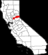
Placer County is a county
located in both the Sacramento Valley
and Sierra Nevada regions of the U.S. state
of California
, in what is known as the Gold Country
. It stretches from the suburbs of Sacramento
to Lake Tahoe
and the Nevada
border. Because of the expansion of the Greater Sacramento, Placer County is one of the fastest growing counties in California. Between 2000 and 2010, the population grew from 248,399 to 348,432. The county seat
is Auburn
.
Placer County was home to the Maidu and Miwok Native Americans for hundreds of years.
County (United States)
In the United States, a county is a geographic subdivision of a state , usually assigned some governmental authority. The term "county" is used in 48 of the 50 states; Louisiana is divided into parishes and Alaska into boroughs. Parishes and boroughs are called "county-equivalents" by the U.S...
located in both the Sacramento Valley
Sacramento Valley
The Sacramento Valley is the portion of the California Central Valley that lies to the north of the San Joaquin-Sacramento Delta in the U.S. state of California. It encompasses all or parts of ten counties.-Geography:...
and Sierra Nevada regions of the U.S. state
U.S. state
A U.S. state is any one of the 50 federated states of the United States of America that share sovereignty with the federal government. Because of this shared sovereignty, an American is a citizen both of the federal entity and of his or her state of domicile. Four states use the official title of...
of California
California
California is a state located on the West Coast of the United States. It is by far the most populous U.S. state, and the third-largest by land area...
, in what is known as the Gold Country
Gold Country
Gold Country is a region in the central and northeastern part of California, United States. It is famed for the mineral deposits and gold mines that attracted waves of immigrants, known as the 49ers, during the 1849 California Gold Rush.-Geography:State Route 49 was built through the Gold Country,...
. It stretches from the suburbs of Sacramento
Sacramento, California
Sacramento is the capital city of the U.S. state of California and the county seat of Sacramento County. It is located at the confluence of the Sacramento River and the American River in the northern portion of California's expansive Central Valley. With a population of 466,488 at the 2010 census,...
to Lake Tahoe
Lake Tahoe
Lake Tahoe is a large freshwater lake in the Sierra Nevada of the United States. At a surface elevation of , it is located along the border between California and Nevada, west of Carson City. Lake Tahoe is the largest alpine lake in North America. Its depth is , making it the USA's second-deepest...
and the Nevada
Nevada
Nevada is a state in the western, mountain west, and southwestern regions of the United States. With an area of and a population of about 2.7 million, it is the 7th-largest and 35th-most populous state. Over two-thirds of Nevada's people live in the Las Vegas metropolitan area, which contains its...
border. Because of the expansion of the Greater Sacramento, Placer County is one of the fastest growing counties in California. Between 2000 and 2010, the population grew from 248,399 to 348,432. The county seat
County seat
A county seat is an administrative center, or seat of government, for a county or civil parish. The term is primarily used in the United States....
is Auburn
Auburn, California
Auburn is the county seat of Placer County, California. Its population at the 2010 census was 13,330. Auburn is known for its California Gold Rush history.Auburn is part of the Greater Sacramento area.- History :...
.
Placer County was home to the Maidu and Miwok Native Americans for hundreds of years.
Unanswered Questions