
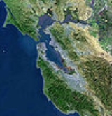
San Francisco Peninsula
Encyclopedia
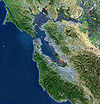
Peninsula
A peninsula is a piece of land that is bordered by water on three sides but connected to mainland. In many Germanic and Celtic languages and also in Baltic, Slavic and Hungarian, peninsulas are called "half-islands"....
in the San Francisco Bay Area
San Francisco Bay Area
The San Francisco Bay Area, commonly known as the Bay Area, is a populated region that surrounds the San Francisco and San Pablo estuaries in Northern California. The region encompasses metropolitan areas of San Francisco, Oakland, and San Jose, along with smaller urban and rural areas...
that separates the San Francisco Bay
San Francisco Bay
San Francisco Bay is a shallow, productive estuary through which water draining from approximately forty percent of California, flowing in the Sacramento and San Joaquin rivers from the Sierra Nevada mountains, enters the Pacific Ocean...
from the Pacific Ocean
Pacific Ocean
The Pacific Ocean is the largest of the Earth's oceanic divisions. It extends from the Arctic in the north to the Southern Ocean in the south, bounded by Asia and Australia in the west, and the Americas in the east.At 165.2 million square kilometres in area, this largest division of the World...
. On its northern tip is the City and County of San Francisco. Its southern base is in Santa Clara County
Santa Clara County, California
Santa Clara County is a county located at the southern end of the San Francisco Bay Area in the U.S. state of California. As of 2010 it had a population of 1,781,642. The county seat is San Jose. The highly urbanized Santa Clara Valley within Santa Clara County is also known as Silicon Valley...
, including the cities of Palo Alto
Palo Alto, California
Palo Alto is a California charter city located in the northwest corner of Santa Clara County, in the San Francisco Bay Area of California, United States. The city shares its borders with East Palo Alto, Mountain View, Los Altos, Los Altos Hills, Stanford, Portola Valley, and Menlo Park. It is...
, Los Altos
Los Altos, California
Los Altos is a city at the southern end of the San Francisco Peninsula, in the San Francisco Bay Area. The city is in Santa Clara County, California, United States. The population was 28,976 according to the 2010 census....
, and Mountain View
Mountain View, California
-Downtown:Mountain View has a pedestrian-friendly downtown centered on Castro Street. The downtown area consists of the seven blocks of Castro Street from the Downtown Mountain View Station transit center in the north to the intersection with El Camino Real in the south...
. Most of the Peninsula is occupied by San Mateo County
San Mateo County, California
San Mateo County is a county located in the San Francisco Bay Area of the U.S. state of California. It covers most of the San Francisco Peninsula just south of San Francisco, and north of Santa Clara County. San Francisco International Airport is located at the northern end of the county, and...
, between San Francisco and Santa Clara counties, and including the cities and towns of Atherton
Atherton, California
Atherton is an incorporated town in San Mateo County, California, United States. Its population was 6,914 at the 2010 census. In September 2010, Forbes magazine placed Atherton's zip code of 94027 at #2 on its annual list of America's most expensive zip codes, with a median home price of $4,010,200...
, Belmont
Belmont, California
Belmont is a city in San Mateo County, California, United States. It is in the San Francisco Bay Area, located half-way down the San Francisco Peninsula between San Mateo and San Carlos. It was originally part of the Rancho de las Pulgas, for which one of its main roads, the Alameda de las Pulgas,...
, Brisbane
Brisbane, California
Brisbane is a small city located in the northern part of San Mateo County, California on the lower slopes of San Bruno Mountain. It is on the northeastern edge of South San Francisco, next to the San Francisco Bay and near the San Francisco International Airport.The population was 4,282 as of...
, Burlingame
Burlingame, California
Burlingame is a city in San Mateo County, California. It is located on the San Francisco Peninsula and has a significant shoreline on San Francisco Bay. The city is named after diplomat Anson Burlingame. It is renowned for its many surviving examples of Victorian architecture, its affluence, and...
, Colma
Colma, California
Colma is a small incorporated town in San Mateo County, California, at the northern end of the San Francisco Peninsula in the San Francisco Bay Area. The population was 1,792 at the 2010 census. The town was founded as a necropolis in 1924....
, Daly City
Daly City, California
Daly City is the largest city in San Mateo County, California, United States, with a 2010 population of 101,123. Located immediately south of San Francisco, it is named in honor of businessman and landowner John Daly.-History:...
, East Palo Alto
East Palo Alto, California
East Palo Alto is a city in San Mateo County, California, United States.-Overview:As of the 2010 census, the population of East Palo Alto was 28,155. It is situated on the San Francisco Peninsula, roughly halfway between the cities of San Francisco and San Jose...
, El Granada
El Granada, California
El Granada is a census-designated place in the coastal area of northern San Mateo County, California, United States. The population was 5,467 at the 2010 census.-Geography:...
, Foster City
Foster City, California
Foster City is an affluent planned city located in San Mateo County, California, 94404. As of the 2010 census, the city had a total population of 30,567. Forbes ranked Foster City #10 on their 2009 list of America's Top 25 Towns to Live Well. Money has also recognized Foster City multiple times as...
, Hillsborough
Hillsborough, California
Hillsborough is an incorporated town in San Mateo County, California, in the San Francisco Bay Area. Hillsborough is one of the wealthiest communities in America and has the highest income of places in the United States with populations of at least 10,000...
, La Honda
La Honda, California
La Honda is a census-designated place in southern San Mateo County, California, United States. The population was 928 at the 2010 census. It is located in the Santa Cruz Mountains between Silicon Valley and the Pacific coast of California...
, Menlo Park
Menlo Park, California
Menlo Park, California is a city at the eastern edge of San Mateo County, in the San Francisco Bay Area of California, in the United States. It is bordered by San Francisco Bay on the north and east; East Palo Alto, Palo Alto, and Stanford to the south; Atherton, North Fair Oaks, and Redwood City...
, Millbrae
Millbrae, California
Millbrae is a city in San Mateo County, California, United States, just west of San Francisco Bay, with San Bruno on the north and Burlingame on the south. The population was 21,532 at the 2010 census.-History:...
, Montara
Montara, California
Montara is a census-designated place in San Mateo County, California, United States. The population was 2,909 at the 2010 census. Nearby communities include Moss Beach and Princeton-by-the-Sea.-Geography and environment:...
, Pacifica
Pacifica, California
Pacifica is a city in San Mateo County, California, on the coast of the Pacific Ocean between San Francisco and Half Moon Bay.-Overview:The City of Pacifica is spread along a six mile stretch of the north central California coastal beach and hills, nestled in several small valleys spanning between...
, Pescadero
Pescadero, California
Pescadero is a census-designated place in San Mateo County, California two miles east of State Route 1 and Pescadero State Beach. The center of town, on Pescadero Creek Road, is located at latitude 37.255 and longitude 122.38028. The town is south of Half Moon Bay. The ZIP Code is 94060 and...
, Portola Valley
Portola Valley, California
Portola Valley is an incorporated town in San Mateo County, California, United States. The population was 4,353 at the 2010 census. It was named for Spanish explorer Gaspar de Portola, who led the first party of Europeans to explore the San Francisco Peninsula, in 1769.Portola Valley is one of the...
, Redwood City
Redwood City, California
Redwood City is a California charter city located on the San Francisco Peninsula in Northern California, approximately 27 miles south of San Francisco, and 24 miles north of San Jose. Redwood City's history spans from its earliest inhabitation by the Ohlone people, to its tradition as a port for...
, San Bruno
San Bruno, California
San Bruno is a city in San Mateo County, California, United States. The population was 41,114 at the 2010 census.The city is adjacent to San Francisco International Airport and Golden Gate National Cemetery.-Geography:San Bruno is located at...
, San Carlos
San Carlos, California
San Carlos is a city in San Mateo County, California, USA on the San Francisco Peninsula, about halfway between San Francisco and San Jose. It is an affluent small residential suburb located between Belmont to the north and Redwood City to the south. San Carlos' ZIP code is 94070, and it is within...
, San Gregorio
San Gregorio, California
-History:Named after Pope Gregory I , San Gregorio was a booming town in the 1850s, when wealthy San Franciscans would travel to the San Gregorio House by stagecoach to enjoy fishing, hunting, sea bathing, and boat races. The building still stands, but is no longer a functioning hotel. However, the...
, San Mateo
San Mateo, California
San Mateo is a city in San Mateo County, California, United States, in the San Francisco Bay Area. With a population of approximately 100,000 , it is one of the larger suburbs on the San Francisco Peninsula, located between Burlingame to the north, Foster City to the east, Belmont to the south,...
, South San Francisco
South San Francisco, California
South San Francisco is a city in San Mateo County, California, United States, located on the San Francisco Peninsula in the San Francisco Bay Area...
, and Woodside
Woodside, California
Woodside is a small incorporated town in San Mateo County, California, United States, on the San Francisco Peninsula. It uses a council-manager system of government. The U.S. Census estimated the population of the town to be 5,287 in 2010....
.
Whereas the term peninsula technically refers to the entire geographical San Franciscan Peninsula, in local terms, The Peninsula does not include San Francisco.
History
In 1795, Governor Diego de BoricaDiego de Borica
Diego de Borica was a Spanish explorer and the seventh Governor of Las Californias from 1794 to 1800, and is credited with defining Alta- and Baja-California's official borders.-Biography:...
gave José Darío Argüello
José Darío Argüello
José Darío Argüello was a Spanish soldier and California pioneer, and twice governor of California.-Biography:José Darío Argüello was born in Santiago de Querétaro, New Spain ....
a Spanish land grant
Ranchos of California
The Spanish, and later the Méxican government encouraged settlement of territory now known as California by the establishment of large land grants called ranchos, from which the English ranch is derived. Devoted to raising cattle and sheep, the owners of the ranchos attempted to pattern themselves...
known as Rancho de las Pulgas
Rancho de las Pulgas
Rancho de las Pulgas was a 1795 Spanish land grant in present day San Mateo County, California to José Darío Argüello. The name means "Ranch of the Fleas". The grant was bounded by San Mateo Creek on the north and San Francisquito Creek on the south, and extended about one league from San...
. This rancho was the largest grant on the peninsula consisting of 35260 acres (142.7 km²).
As a local geographic term, "The Peninsula" is distinct from "The City", and refers to the portion south of San Francisco. The appellation may date to the period, prior to 1856, when the City of San Francisco and the County of San Francisco were separate entities, the latter then coextensive with contemporary San Mateo County and San Francisco City-County. The City-County owns several disjunct properties along the whole of the Peninsula (mostly water pumping stations connected to the Hetch Hetchy Valley
Hetch Hetchy Valley
Hetch Hetchy Valley is a glacial valley in Yosemite National Park in California. It is currently completely flooded by O'Shaughnessy Dam, forming the Hetch Hetchy Reservoir. The Tuolumne River fills the reservoir. Upstream from the valley lies the Grand Canyon of the Tuolumne. The reservoir...
on which San Francisco has a permanent leasehold); thus, most of the larger communities in San Mateo County are de facto suburbs of San Francisco, with the neighboring communities of Pacifica, Daly City, Broadmoor, Colma, South San Francisco, San Bruno, and Brisbane being immediate suburbs. The remaining suburban area of the Peninsula is on the east side of the Santa Cruz Mountains
Santa Cruz Mountains
The Santa Cruz Mountains, part of the Pacific Coast Ranges, are a mountain range in central California, United States. They form a ridge along the San Francisco Peninsula, south of San Francisco, separating the Pacific Ocean from San Francisco Bay and the Santa Clara Valley, and continuing south,...
, along San Francisco Bay
San Francisco Bay
San Francisco Bay is a shallow, productive estuary through which water draining from approximately forty percent of California, flowing in the Sacramento and San Joaquin rivers from the Sierra Nevada mountains, enters the Pacific Ocean...
; the west and south-central portions of the Peninsula are mostly rural, unincorporated and unorganised areas.
Boundaries
The east side of the peninsula is a largely densely populated area that includes portions of Silicon ValleySilicon Valley
Silicon Valley is a term which refers to the southern part of the San Francisco Bay Area in Northern California in the United States. The region is home to many of the world's largest technology corporations...
. It forms a commuter area between San Francisco to the north and San Jose
San Jose, California
San Jose is the third-largest city in California, the tenth-largest in the U.S., and the county seat of Santa Clara County which is located at the southern end of San Francisco Bay...
to the south. A number of major thoroughfares run north-south: El Camino Real
El Camino Real (California)
El Camino Real and sometimes associated with Calle Real usually refers to the 600-mile California Mission Trail, connecting the former Alta California's 21 missions , 4 presidios, and several pueblos, stretching from Mission San Diego de Alcalá in San Diego...
(SR 82
California State Route 82
State Route 82 is a state highway in the U.S. state of California that runs from U.S. Route 101 at Blossom Hill Road in San Jose to Interstate 280 in San Francisco following the San Francisco Peninsula...
) and US 101 on the east side along the bay, Interstate 280
Interstate 280 (California)
Interstate 280 is a 57-mile long north–south Interstate Highway in the San Francisco Bay Area of Northern California. It connects San Jose and San Francisco, running along just to the west of the cities of San Francisco Peninsula for most of its route.I-280 from its northern end at King...
down the center, Skyline Boulevard (SR 35
California State Route 35
State Route 35 in the U.S. state of California, generally known as Skyline Boulevard, is a two-lane road running along the western ridge of Silicon Valley in California. It runs from Highway 17 to San Francisco at State Route 1. It provides scenic views of both the Santa Cruz Mountains, the...
) along the crest of the Santa Cruz Mountains
Santa Cruz Mountains
The Santa Cruz Mountains, part of the Pacific Coast Ranges, are a mountain range in central California, United States. They form a ridge along the San Francisco Peninsula, south of San Francisco, separating the Pacific Ocean from San Francisco Bay and the Santa Clara Valley, and continuing south,...
, and Highway 1
California State Route 1
State Route 1 , more often called Highway 1, is a state highway that runs along much of the Pacific coast of the U.S. state of California. It is famous for running along some of the most beautiful coastlines in the world, leading to its designation as an All-American Road.Highway 1 does not run...
on the west along the Pacific. The Caltrain
Caltrain
Caltrain is a California commuter rail line on the San Francisco Peninsula and in the Santa Clara Valley in the United States. The northern terminus of the rail line is in San Francisco, at 4th and King streets; its southern terminus is in Gilroy...
commuter rail line runs roughly parallel to the El Camino Real (State Route 82) and Highway 101 corridors.
Three bridges—the Dumbarton Bridge
Dumbarton Bridge (California)
The Dumbarton Bridge is the southernmost of the highway bridges that span the San Francisco Bay in California. Carrying over 81,000 vehicles daily, it is also the shortest bridge across San Francisco Bay at 1.63 miles...
, the San Mateo-Hayward Bridge, and the San Francisco – Oakland Bay Bridge—cross San Francisco Bay
San Francisco Bay
San Francisco Bay is a shallow, productive estuary through which water draining from approximately forty percent of California, flowing in the Sacramento and San Joaquin rivers from the Sierra Nevada mountains, enters the Pacific Ocean...
from the Peninsula. To the north, the Golden Gate Bridge
Golden Gate Bridge
The Golden Gate Bridge is a suspension bridge spanning the Golden Gate, the opening of the San Francisco Bay into the Pacific Ocean. As part of both U.S. Route 101 and California State Route 1, the structure links the city of San Francisco, on the northern tip of the San Francisco Peninsula, to...
connects San Francisco with Marin County
Marin County, California
Marin County is a county located in the North San Francisco Bay Area of the U.S. state of California, across the Golden Gate Bridge from San Francisco. As of 2010, the population was 252,409. The county seat is San Rafael and the largest employer is the county government. Marin County is well...
.
Along the center line of the Peninsula is the northern half of the Santa Cruz Mountains
Santa Cruz Mountains
The Santa Cruz Mountains, part of the Pacific Coast Ranges, are a mountain range in central California, United States. They form a ridge along the San Francisco Peninsula, south of San Francisco, separating the Pacific Ocean from San Francisco Bay and the Santa Clara Valley, and continuing south,...
, formed by the action of plate tectonics
Plate tectonics
Plate tectonics is a scientific theory that describes the large scale motions of Earth's lithosphere...
along the San Andreas Fault
San Andreas Fault
The San Andreas Fault is a continental strike-slip fault that runs a length of roughly through California in the United States. The fault's motion is right-lateral strike-slip...
. In the middle of the Peninsula along the fault is the Crystal Springs reservoir
Crystal Springs Park, California
Crystal Springs is a county park located between San Bruno to the north and Woodside to the south. The park comprises two main trails, Sawyer Camp Trail in the southern end and San Andreas trail in the northern section, which run along the eastern shore of San Andreas Lake in San Mateo...
. Just north of the Crystal Springs reservoir is San Andreas Lake
San Andreas Lake
San Andreas Lake is a reservoir adjacent to the San Francisco Peninsula cities of Millbrae and San Bruno in San Mateo County, California. It is situated directly on the San Andreas Fault, which is named after the lake.- History :...
after which the famous geologic fault was named.
Environmental features
The San Francisco Peninsula contains a variety of habitats including estuarineEstuary
An estuary is a partly enclosed coastal body of water with one or more rivers or streams flowing into it, and with a free connection to the open sea....
, marine, oak woodland, redwood forest, coastal scrub and oak savanna
Savanna
A savanna, or savannah, is a grassland ecosystem characterized by the trees being sufficiently small or widely spaced so that the canopy does not close. The open canopy allows sufficient light to reach the ground to support an unbroken herbaceous layer consisting primarily of C4 grasses.Some...
. There are numerous species of wildlife present, especially along the San Francisco Bay
San Francisco Bay
San Francisco Bay is a shallow, productive estuary through which water draining from approximately forty percent of California, flowing in the Sacramento and San Joaquin rivers from the Sierra Nevada mountains, enters the Pacific Ocean...
estuarine
Estuary
An estuary is a partly enclosed coastal body of water with one or more rivers or streams flowing into it, and with a free connection to the open sea....
shoreline, San Bruno Mountain
San Bruno Mountain
San Bruno Mountain in northern San Mateo County, California is the northernmost part of the Santa Cruz Mountains. Most of the mountain lies within the San Bruno Mountain State Park, a unique open-space island in the midst of the San Francisco Peninsula's urbanization. Next to the state park is the...
, Fitzgerald Marine Reserve
Fitzgerald Marine Reserve
Fitzgerald Marine Reserve is a marine reserve in California on the Pacific Ocean, located just north of Pillar Point Harbor and Mavericks in the San Mateo County community of Moss Beach. Moss Beach is located approximately south of San Francisco and north of Santa Cruz. The reserve is a holding...
and the forest
Forest
A forest, also referred to as a wood or the woods, is an area with a high density of trees. As with cities, depending where you are in the world, what is considered a forest may vary significantly in size and have various classification according to how and what of the forest is composed...
s on the Montara Mountain
Montara Mountain
Montara Mountain, positioned between the unincorporated community of Montara, California to the southwest and the city of Pacifica, California to the north, forms the northern spur of the Santa Cruz Mountains, a narrow mountain range running the length of the San Francisco Peninsula that separates...
block.
The county is home to several endangered species including the San Francisco garter snake
San Francisco garter snake
The San Francisco Garter Snake is a slender multi-colored colubrid snake. Designated as an endangered species since the year 1967, it is endemic to California and resides only in San Mateo County, California, and the extreme northern part of coastal Santa Cruz County, California...
, the Mission blue butterfly
Mission blue butterfly
The Mission Blue is a blue or lycaenid butterfly subspecies native to the San Francisco Bay Area of the United States. The butterfly has been declared as endangered by the US Federal Government. It is a subspecies of Boisduval's Blue .- Description :The endangered Mission Blue has a wingspan of...
and the San Bruno elfin butterfly
San Bruno elfin butterfly
The San Bruno elfin butterfly is a U.S. Federally listed endangered subspecies which inhabits rocky outcrops and cliffs in coastal scrub on the San Francisco peninsula, endemic to this habitat in California...
, all of which are endemic to San Mateo County. The endangered
Endangered species
An endangered species is a population of organisms which is at risk of becoming extinct because it is either few in numbers, or threatened by changing environmental or predation parameters...
California clapper rail
California Clapper Rail
The California Clapper Rail is an endangered subspecies of the Clapper Rail . It is found principally in California's San Francisco Bay, and also in Monterey Bay and Morro Bay...
is also found on the shores of San Francisco Bay
San Francisco Bay
San Francisco Bay is a shallow, productive estuary through which water draining from approximately forty percent of California, flowing in the Sacramento and San Joaquin rivers from the Sierra Nevada mountains, enters the Pacific Ocean...
, in the cities of Belmont
Belmont, California
Belmont is a city in San Mateo County, California, United States. It is in the San Francisco Bay Area, located half-way down the San Francisco Peninsula between San Mateo and San Carlos. It was originally part of the Rancho de las Pulgas, for which one of its main roads, the Alameda de las Pulgas,...
and San Mateo
San Mateo, California
San Mateo is a city in San Mateo County, California, United States, in the San Francisco Bay Area. With a population of approximately 100,000 , it is one of the larger suburbs on the San Francisco Peninsula, located between Burlingame to the north, Foster City to the east, Belmont to the south,...
.
A number of noteworthy parks and nature preserves are found on the San Francisco Peninsula, including:
- Edgewood ParkEdgewood ParkEdgewood Park can refer to:* Edgewood Park in New Haven, Connecticut* Edgewood Park & Natural Preserve, San Mateo County, California* Edgewood Park neighborhood in Fort Erie, Ontario* Edgewood Park neighborhood in Fort Wayne, Indiana...
, San Mateo County - Golden Gate National Recreation AreaGolden Gate National Recreation AreaThe Golden Gate National Recreation Area is a U.S. National Recreation Area administered by the National Park Service that surrounds the San Francisco Bay area. It is one of the most visited units of the National Park system in the United States, with over 13 million visitors a year...
- several units are located on the Peninsula - Midpeninsula Regional Open Space DistrictMidpeninsula Regional Open Space DistrictThe Midpeninsula Regional Open Space District is a special-purpose district that manages over of open space in 25 preserves in the San Francisco Bay Area. It includes parts of Santa Clara, San Mateo and Santa Cruz Counties. The District was created by voter initiative in 1972...
- several preserves - Sanborn ParkSanborn ParkSanborn Park is a public park situated in the Santa Cruz Mountains owned and managed by the county of Santa Clara, California. The park, originally named Sanborn-Skyline County Park is also known as Sanborn Skyline Park or Sanborn County Park. The holding is heavily forested and offers hiking...
, Santa Clara County
Notable structures
There are a number of well known structures and complexes on the San Francisco Peninsula:- Bay MeadowsBay MeadowsBay Meadows was a horse racing track in San Mateo, California, in the San Francisco Bay Area in the United States.-History:Built on the site of an old airfield, Bay Meadows Racecourse was the longest continually operating thoroughbred racetrack in California, having been founded on November 13,...
Racecourse, San Mateo (demolished in 2008) - Carolands Mansion, Hillsborough
- Cow PalaceCow PalaceCow Palace is an indoor arena, in Daly City, California, situated on the city's border with neighboring San Francisco, notable as a sporting arena.-History:...
, Daly City - Crocker Mansion, Hillsborough
- Crystal Springs ReservoirCrystal Springs ReservoirCrystal Springs Reservoir is a pair of artificial lakes located in the northern Santa Cruz Mountains of San Mateo County, California situated in the rift valley created by the San Andreas Fault just to the west of the cities of San Mateo and Hillsborough, and I-280...
, unincorporatedMunicipal corporationA municipal corporation is the legal term for a local governing body, including cities, counties, towns, townships, charter townships, villages, and boroughs. Municipal incorporation occurs when such municipalities become self-governing entities under the laws of the state or province in which...
central part of county - CuriOdyssey museum, San Mateo
- Dakin BuildingDakin BuildingThe Dakin Building is an architectural award-winning class A office building on the San Francisco Bay in Brisbane, California. Serving as a corporate headquarters building for several companies of national prominence, it was built from the profits of the Garfield character whose licensed products...
, Brisbane - Filoli mansionFiloliFiloli is a country house set in of formal gardens surrounded by estate, located in Woodside, California, about 25 miles south of San Francisco, at the southern end of Crystal Springs Lake, on the eastern slope of the Santa Cruz Mountains....
, Woodside - The "The Flintstone HouseThe Flintstone HouseThe Flintstone House is a house in Hillsborough, California overlooking, and best seen from the Eugene A. Doran Memorial Bridge on Interstate 280. It was designed by architect William Nicholson and built in 1976 as an experiment in new building materials, in the form of a series of domes...
", north of the Eugene Doran Bridge on the east side of Interstate 280 http://www.thewavemag.com/pagegen.php?pagename=article&articleid=24784 - Notre Dame de Namur UniversityNotre Dame de Namur UniversityNotre Dame de Namur University — formerly the College of Notre Dame — is a private, Catholic University located in Belmont, California in the San Francisco Bay Area. Notre Dame de Namur University is an accredited university in San Mateo County, and the fifth-oldest university in California...
, Belmont, which incorporates Ralston HallRalston HallRalston Hall Mansion located in Belmont, California, was the country house of William Chapman Ralston, a San Francisco businessman, founder of the Bank of California, and financier of the Comstock Lode. It is an opulent Italianate Villa, modified with touches of Steamboat Gothic and Victorian... - OracleOracle CorporationOracle Corporation is an American multinational computer technology corporation that specializes in developing and marketing hardware systems and enterprise software products – particularly database management systems...
World Headquarters, Redwood Shores (aka the "Emerald City") - Pulgas Water TemplePulgas Water TempleThe Pulgas Water Temple is a stone structure in Woodside, California, USA, designed by architect William G. Merchant. It was erected by the San Francisco Water Department to commemorate the 1934 completion of the Hetch Hetchy Aqueduct and is located at the aqueduct's terminus...
, Woodside - San Francisco International AirportSan Francisco International AirportSan Francisco International Airport is a major international airport located south of downtown San Francisco, California, United States, near the cities of Millbrae and San Bruno in unincorporated San Mateo County. It is often referred to as SFO...
- Sanchez Adobe, Pacifica
- Stanford UniversityStanford UniversityThe Leland Stanford Junior University, commonly referred to as Stanford University or Stanford, is a private research university on an campus located near Palo Alto, California. It is situated in the northwestern Santa Clara Valley on the San Francisco Peninsula, approximately northwest of San...
, Stanford near Palo Alto