

Mount Rainier
Encyclopedia
Mount Rainier is a massive stratovolcano
located 54 miles (87 km) southeast of Seattle
in the state of Washington, United States
. It is the most topographically prominent
mountain in the contiguous United States
and the Cascade Volcanic Arc
, with a summit elevation of 14411 feet (4,392 m). Mt. Rainier is considered one of the most dangerous volcanoes in the world, and it is on the Decade Volcano list. Because of its large amount of glacial ice, Mt. Rainier could potentially produce massive lahar
s that would threaten the whole Puyallup River
valley.
of 13211 feet (4,026.7 m), greater than that of K2
(13189 feet (4,020 m)).
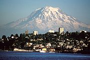
On clear days it dominates the southeastern horizon in most of the Seattle-Tacoma metropolitan area
to such an extent that locals sometimes refer to it simply as "the Mountain."
On days of exceptional clarity, it can also be seen from as far away as Portland, Oregon
, and Victoria, British Columbia
.
With 26 major glaciers and 36 square miles (93.2 km²) of permanent snowfields and glacier
s, Mount Rainier is the most heavily glaciated peak in the lower 48 states. The summit is topped by two volcanic crater
s, each more than 1000 feet (304.8 m) in diameter with the larger east crater overlapping the west crater. Geothermal heat from the volcano
keeps areas of both crater rims free of snow and ice, and has formed the world's largest volcanic glacier cave
network within the ice-filled craters, with nearly 2 miles (3.2 km) of passages. A small crater lake
about 130 by in size and 16 feet (5 m) deep, the highest in North America with a surface elevation of 14203 feet (4,329 m), occupies the lowest portion of the west crater below more than 100 feet (30.5 m) of ice and is accessible only via the caves.
The Carbon
, Puyallup
, Mowich
, Nisqually
, and Cowlitz River
s begin at eponymous glaciers of Mount Rainier. The sources of the White River
are Winthrop
, Emmons
, and Fryingpan Glacier
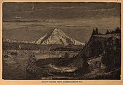
s. The White, Carbon, and Mowich join the Puyallup River, which discharges into Commencement Bay
at Tacoma
; the Nisqually empties into Puget Sound
east of Lacey
; and the Cowlitz joins the Columbia River
between Kelso
and Longview
.
of about 138 feet (42 m), so it is not considered a separate peak. The lowest of the three summits is Liberty Cap, 14112 feet (4,301 m), at the northwestern edge, which overlooks Liberty Ridge, the Sunset Amphitheater, and the dramatic Willis Wall. Liberty Cap has a prominence of 492 feet (150 m), and so would qualify as a separate peak under most of strictly prominence-based rules. A prominence cutoff of 400 feet (122 m) is commonly used in Washington state.
High on the eastern flank of Mount Rainier is a peak known as Little Tahoma Peak, 11138 feet (3,395 m), an eroded remnant of the earlier, much higher, Mount Rainier. It has a prominence of 858 feet (262 m), and it is almost never climbed in direct conjunction with Columbia Crest, so it is usually considered a separate peak. If considered separately from Mt. Rainier, Little Tahoma Peak would be the third highest mountain peak in Washington.
in the Cascade Volcanic Arc. Its early lava
deposits are estimated at more than 840,000 years old and are part of the Lily Formation (about 2.9 million to 840,000 years ago). The early deposits formed a "proto-Rainier" or an ancestral cone prior to the present-day cone. The present cone is more than 500,000 years old.
The volcano is highly eroded, with glaciers on its slopes, and appears to be made mostly of andesite
. Rainier likely once stood even higher than today at about 16000 feet (4,876.8 m) before a major debris avalanche
and the resulting Osceola Mudflow approximately 5,000 years ago.
 In the past, Rainier has had large debris avalanches, and has also produced enormous lahar
s (volcanic
mudflow
s) due to the large amount of glacial ice present. Its lahars have reached all the way to Puget Sound
, a distance of more than 30 miles (48.3 km). Around 5,000 years ago, a large chunk of the volcano slid away and that debris avalanche helped to produce the massive Osceola Mudflow, which went all the way to the site of present-day Tacoma
and south Seattle.
This massive avalanche of rock and ice removed the top 1600 feet (487.7 m) of Rainier, bringing its height down to around 14100 feet (4,297.7 m). About 530 to 550 years ago, the Electron Mudflow occurred, although this was not as large-scale as the Osceola Mudflow.
After the major collapse approximately 5,000 years ago, subsequent eruptions of lava and tephra
built up the modern summit cone until about as recently as 1,000 years ago. As many as 11 Holocene
tephra layers have been found.
 The most recent recorded volcanic eruption was between 1820 and 1854, but many eyewitnesses reported eruptive activity in 1858, 1870, 1879, 1882 and 1894 as well.
Although Mount Rainier is an active volcano, there was no evidence of an imminent eruption. However, an eruption could be devastating for all areas surrounding the volcano. Mount Rainier is currently listed as a Decade Volcano, or one of the 16 volcanoes with the greatest likelihood of causing great loss of life and property if eruptive activity resumes. If Mt. Rainier were to erupt as powerfully as Mount St. Helens
did in its May 18, 1980 eruption, the effect would be cumulatively greater, because of the far more massive amounts of glacial ice locked on the volcano
compared to Mount St. Helens and the vastly more heavily populated areas surrounding Rainier.
Lahars from Rainier pose the most risk to life and property, as many communities lie atop older lahar deposits. According to USGS, about 150,000 people live on top of old lahar deposits of Rainier. Not only is there much ice atop the volcano, the volcano is also slowly being weakened by hydrothermal activity. According to Geoff Clayton, a geologist with a Washington State Geology firm, RH2 Engineering, a repeat of the Osceola mudflow would destroy Enumclaw
, Orting
, Kent
, Auburn
, Puyallup
, Sumner
and all of Renton
. Such a mudflow might also reach down the Duwamish
estuary and destroy parts of downtown Seattle, and cause tsunami
s in Puget Sound
and Lake Washington
. Another Cascade Arc volcano with similar hazards is Mount Meager
in southwestern British Columbia
, Canada
, which has produced several large landslides in the past 8,000 years, as well as an eruption 2,350 years ago that was similar in size to Mount St. Helens' 1980 eruption. Rainier is also capable of producing pyroclastic flow
s and lava.
According to K. Scott, a scientist with the USGS:
The volcanic risk is somewhat mitigated by lahar warning sirens and escape route signs in Pierce County
. However, although more populous King County is also in the Lahar area, there are currently no zoning restrictions in King County due to volcanic hazard. More recently (since 2001) funding from the federal government for lahar
protection in the area has dried up, leading local authorities in at-risk cities like Orting
to fear a disaster similar to the Armero tragedy.
s are among the most conspicuous and dynamic geologic features on Mount Rainier. They erode the volcanic cone and are important sources of streamflow for several rivers, including some that provide water for hydroelectric power and irrigation
. Together with perennial snow patches, the 26 major glaciers cover about 36 square miles (93.2 km²) of the mountain's surface and have a volume of about 1 cubic miles (4.2 km³).
Glaciers flow under the influence of gravity by the combined action of sliding over the rock on which they lie and by deformation
, the gradual displacement between and within individual ice crystals. Maximum speeds occur near the surface and along the centerline of the glacier. During May, 1970, Nisqually Glacier
was measured moving as fast as 29 inches (73.7 cm) per day. Flow rates are generally greater in summer than in winter, probably due to the presence of large quantities of meltwater at the glacier base.
The size of glaciers on Mount Rainier has fluctuated significantly in the past. For example, during the last ice age
, from about 25,000 to about 15,000 years ago, glaciers covered most of the area now within the boundaries of Mount Rainier National Park and extended to the perimeter of the present Puget Sound
Basin.
Between the 14th century and 1850, many of the glaciers on Mount Rainier advanced to their farthest extent downvalley since the last ice age. Many advances of this sort occurred worldwide during this time period known to geologists as the Little Ice Age
. During the Little Ice Age, the Nisqually Glacier advanced to a position 650 to 800 ft (198.1 to 243.8 m) downvalley from the site of the Glacier Bridge, Tahoma
and South Tahoma Glacier
s merged at the base of Glacier Island, and the terminus of Emmons Glacier
reached within 1.2 miles (1.9 km) of the White River Campground.
Retreat of the Little Ice Age glaciers
was slow until about 1920 when retreat became more rapid. Between the height of the Little Ice Age and 1950, Mount Rainier's glaciers lost about one-quarter of their length. Beginning in 1950 and continuing through the early 1980s, however, many of the major glaciers advanced in response to relatively cooler temperatures of the mid-century. The Carbon
, Cowlitz
, Emmons, and Nisqually Glaciers advanced during the late 1970s and early 1980s as a result of high snowfalls during the 1960s and 1970s. Since the early-1980s, however, many glaciers have been thinning and retreating and some advances have slowed.
 Mount Rainier was first known by the Native Americans
as Talol, or Tacoma, from the Lushootseed
word təqʷúʔbəʔ ("mother of waters") spoken by the Puyallup
. Another interpretation is that "Tacoma", effectively means "larger than Koma (Kulshan)".
(a name for Mount Baker
), cf. "Kobah" (Skagit: qwúbəʔ, "white sentinel", i.e. mountain").
At the time of European contact, the river valleys and other areas near the mountain were inhabited by many Pacific Northwest
tribes who hunted and gathered berries in its forests and mountain meadows. These included the Nisqually
, Cowlitz
, Yakama
, Puyallup
, and Muckleshoot
.
 Captain
George Vancouver
reached Puget Sound
in early May 1792 and became the first European to see the mountain. He named it in honor of his friend, Rear Admiral
Peter Rainier
.
In 1833, Dr. William Fraser Tolmie
explored the area looking for medicinal plants. Hazard Stevens
and P. B. Van Trump
received a hero's welcome in the streets of Olympia
after their successful summit climb in 1870.
John Muir
climbed Mount Rainier in 1888, and although he enjoyed the view, he conceded that it was best appreciated from below. Muir was one of many who advocated protecting the mountain. In 1893, the area was set aside as part of the Pacific Forest Reserve
in order to protect its physical/economic resources: timber and watersheds
.
Citing the need to also protect scenery and provide for public enjoyment, railroads and local businesses urged the creation of a national park in hopes of increased tourism. On March 2, 1899, President William McKinley
established Mount Rainier National Park
as America's fifth national park
. Congress dedicated the new park "for the benefit and enjoyment of the people"
and "... for the preservation from injury or spoliation of all timber, mineral
deposits, natural curiosities, or wonders within said park, and their retention in their natural condition."
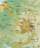
In 1998, the United States Geological Survey
began putting together the Mount Rainier Volcano Lahar Warning System to assist in the emergency evacuation
of the Puyallup River
valley in the event of a catastrophic debris flow. It is now run by the Pierce County
Department of Emergency Management. Tacoma
, at the mouth of the Puyallup, is only 37 miles (60 km) west of Rainier, and moderately sized towns such as Puyallup
and Orting
are only 27 and 20 mi (43.5 and 32.2 km) away, respectively.
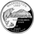 The Washington state quarter
, which was released on April 11, 2007, features Mount Rainier and a salmon
.
, in his posthumously published 1862 travel book The Canoe and the Saddle, referred to the mountain as "Tacoma" and for a time, both names were used interchangeably, although "Mt. Tacoma" was preferred in the city of Tacoma.
In 1890, the United States Board on Geographic Names
declared that the mountain would be known as "Rainier". Following this in 1897, the Pacific Forest Reserve became the Mount Rainier Forest Reserve, and the national park was established three years later. Despite this, there was still a movement to change the mountain's name to "Tacoma" and Congress was still considering a resolution to change the name as late as 1924.
 Mountain climbing on Mount Rainier is difficult, involving traversing the largest glaciers in the U.S. south of Alaska
. Most climbers require two to three days to reach the summit. Climbing teams demand experience in glacier travel, self-rescue, and wilderness travel. About 8,000 to 13,000 people attempt the climb each year,
about 90% via routes from Camp Muir
on the southeast flank.
Most of the rest ascend Emmons Glacier
via Camp Schurman on the northeast. About half of the attempts are successful, with weather and conditioning being the most common reasons for failure.
The worst mountaineering accident on Mount Rainier occurred in 1981, when eleven people lost their lives in an ice fall on the Ingraham Glacier
.
This was the largest number of fatalities on Mount Rainier in a single incident since 32 people were killed in a 1946 plane crash on the South Tahoma Glacier
. About two mountaineering deaths each year occur because of rock and ice fall, avalanche, falls, and hypothermia associated with severe weather (58 reported since and including the 1981 accident through 2010 per American Alpine Club Accidents in North American Mountaineering and the NPS).
Hiking
, backcountry skiing
, photography
, and camping
are popular in the park. Hiking trails, including the Wonderland Trail
(a 93 miles (149.7 km) circumnavigation of the peak), provide access to the backcountry. Mount Rainier is also popular for winter sports, including snowshoe
ing and cross-country skiing
.
University of Washington Libraries, Digital Collections:
Stratovolcano
A stratovolcano, also known as a composite volcano, is a tall, conical volcano built up by many layers of hardened lava, tephra, pumice, and volcanic ash. Unlike shield volcanoes, stratovolcanoes are characterized by a steep profile and periodic, explosive eruptions...
located 54 miles (87 km) southeast of Seattle
Seattle, Washington
Seattle is the county seat of King County, Washington. With 608,660 residents as of the 2010 Census, Seattle is the largest city in the Northwestern United States. The Seattle metropolitan area of about 3.4 million inhabitants is the 15th largest metropolitan area in the country...
in the state of Washington, United States
United States
The United States of America is a federal constitutional republic comprising fifty states and a federal district...
. It is the most topographically prominent
Topographic prominence
In topography, prominence, also known as autonomous height, relative height, shoulder drop , or prime factor , categorizes the height of the mountain's or hill's summit by the elevation between it and the lowest contour line encircling it and no higher summit...
mountain in the contiguous United States
Contiguous United States
The contiguous United States are the 48 U.S. states on the continent of North America that are south of Canada and north of Mexico, plus the District of Columbia....
and the Cascade Volcanic Arc
Cascade Volcanoes
The Cascade Volcanoes are a number of volcanoes in a volcanic arc in western North America, extending from southwestern British Columbia through Washington and Oregon to Northern California, a distance of well over 700 mi ...
, with a summit elevation of 14411 feet (4,392 m). Mt. Rainier is considered one of the most dangerous volcanoes in the world, and it is on the Decade Volcano list. Because of its large amount of glacial ice, Mt. Rainier could potentially produce massive lahar
Lahar
A lahar is a type of mudflow or debris flow composed of a slurry of pyroclastic material, rocky debris, and water. The material flows down from a volcano, typically along a river valley. The term is a shortened version of "berlahar" which originated in the Javanese language of...
s that would threaten the whole Puyallup River
Puyallup River
The Puyallup River is a river in the U.S. state of Washington. About long, it is formed by glaciers on the west side of Mount Rainier. It flows generally northwest, emptying into Commencement Bay, part of Puget Sound...
valley.
Geographical setting
Mount Rainier is the highest mountain in Washington and the Cascade Range. Mount Rainier has a topographic prominenceTopographic prominence
In topography, prominence, also known as autonomous height, relative height, shoulder drop , or prime factor , categorizes the height of the mountain's or hill's summit by the elevation between it and the lowest contour line encircling it and no higher summit...
of 13211 feet (4,026.7 m), greater than that of K2
K2
K2 is the second-highest mountain on Earth, after Mount Everest...
(13189 feet (4,020 m)).
On clear days it dominates the southeastern horizon in most of the Seattle-Tacoma metropolitan area
Seattle metropolitan area
The Seattle metropolitan area in the US state of Washington includes the city of Seattle, King County, Snohomish County, and Pierce County within the Puget Sound region. The U.S...
to such an extent that locals sometimes refer to it simply as "the Mountain."
On days of exceptional clarity, it can also be seen from as far away as Portland, Oregon
Portland, Oregon
Portland is a city located in the Pacific Northwest, near the confluence of the Willamette and Columbia rivers in the U.S. state of Oregon. As of the 2010 Census, it had a population of 583,776, making it the 29th most populous city in the United States...
, and Victoria, British Columbia
Victoria, British Columbia
Victoria is the capital city of British Columbia, Canada and is located on the southern tip of Vancouver Island off Canada's Pacific coast. The city has a population of about 78,000 within the metropolitan area of Greater Victoria, which has a population of 360,063, the 15th most populous Canadian...
.
With 26 major glaciers and 36 square miles (93.2 km²) of permanent snowfields and glacier
Glacier
A glacier is a large persistent body of ice that forms where the accumulation of snow exceeds its ablation over many years, often centuries. At least 0.1 km² in area and 50 m thick, but often much larger, a glacier slowly deforms and flows due to stresses induced by its weight...
s, Mount Rainier is the most heavily glaciated peak in the lower 48 states. The summit is topped by two volcanic crater
Volcanic crater
A volcanic crater is a circular depression in the ground caused by volcanic activity. It is typically a basin, circular in form within which occurs a vent from which magma erupts as gases, lava, and ejecta. A crater can be of large dimensions, and sometimes of great depth...
s, each more than 1000 feet (304.8 m) in diameter with the larger east crater overlapping the west crater. Geothermal heat from the volcano
Volcano
2. Bedrock3. Conduit 4. Base5. Sill6. Dike7. Layers of ash emitted by the volcano8. Flank| 9. Layers of lava emitted by the volcano10. Throat11. Parasitic cone12. Lava flow13. Vent14. Crater15...
keeps areas of both crater rims free of snow and ice, and has formed the world's largest volcanic glacier cave
Glacier cave
A glacier cave is a cave formed within the ice of a glacier. Glacier caves are often called ice caves, but this term is properly used to describe bedrock caves that contain year-round ice.-Overview:...
network within the ice-filled craters, with nearly 2 miles (3.2 km) of passages. A small crater lake
Crater lake
A crater lake is a lake that forms in a volcanic crater or caldera, such as a maar; less commonly and with lower association to the term a lake may form in an impact crater caused by a meteorite. Sometimes lakes which form inside calderas are called caldera lakes, but often this distinction is not...
about 130 by in size and 16 feet (5 m) deep, the highest in North America with a surface elevation of 14203 feet (4,329 m), occupies the lowest portion of the west crater below more than 100 feet (30.5 m) of ice and is accessible only via the caves.
The Carbon
Carbon River
The Carbon River is a river in the U.S. state of Washington. It flows about 30 miles from its source, the Carbon Glacier on Mount Rainier, to join the Puyallup River at Orting....
, Puyallup
Puyallup River
The Puyallup River is a river in the U.S. state of Washington. About long, it is formed by glaciers on the west side of Mount Rainier. It flows generally northwest, emptying into Commencement Bay, part of Puget Sound...
, Mowich
Mowich River
The Mowich River is a river in the U.S. state of Washington. Its watershed drains a portion of the western side of Mount Rainier, part of the Cascade Range. The river has two main headwater branches, the South Mowich River and the North Mowich River. The South Mowich is significantly larger and...
, Nisqually
Nisqually River
The Nisqually River is a river in west central Washington in the United States, approximately long. It drains part of the Cascade Range southwest of Tacoma, including the southern slope of Mount Rainier, and empties into the southern end of Puget Sound....
, and Cowlitz River
Cowlitz River
The Cowlitz River is a river in the state of Washington in the United States, a tributary of the Columbia River. Its tributaries drain a large region including the slopes of Mount Rainier, Mount Adams, and Mount St. Helens....
s begin at eponymous glaciers of Mount Rainier. The sources of the White River
White River (Washington)
The White River is a white, glacial river in the U.S. state of Washington. It flows about 75 miles from its source, the Emmons Glacier on Mount Rainier, to join the Puyallup River at Sumner...
are Winthrop
Winthrop Glacier
The Winthrop Glacier is a large glacier on the northeastern side of Mount Rainier in Washington. Named after Theodore Winthrop, the body of ice covers 3.5 mile2 and has a volume of 18.5 billion feet3 . Starting at over at the Columbia Crest, the glacier heads north and descends steeply over the...
, Emmons
Emmons Glacier
Emmons Glacier is a glacier on the northeast flank of Mount Rainier, in Washington. At , it has the largest surface area of any glacier in the contiguous United States. The glacier was named after the geologist Samuel Franklin Emmons after his involvement in a survey of Mount Rainier in...
, and Fryingpan Glacier
Fryingpan Glacier
The Fryingpan Glacier is a medium-sized glacier on the eastern face of the Little Tahoma Peak just to the east of Mount Rainier in Washington. It covers an area of 1.3 mi2 and contains 2.9 billion ft3 of ice...
s. The White, Carbon, and Mowich join the Puyallup River, which discharges into Commencement Bay
Commencement Bay
Commencement Bay is a bay of Puget Sound in the U.S. state of Washington. The city of Tacoma is located on the bay, with the Port of Tacoma occupying the southeastern end. A line drawn from Point Defiance in the southwest to Browns Point in the northeast serves to mark the generally accepted...
at Tacoma
Tacoma, Washington
Tacoma is a mid-sized urban port city and the county seat of Pierce County, Washington, United States. The city is on Washington's Puget Sound, southwest of Seattle, northeast of the state capital, Olympia, and northwest of Mount Rainier National Park. The population was 198,397, according to...
; the Nisqually empties into Puget Sound
Puget Sound
Puget Sound is a sound in the U.S. state of Washington. It is a complex estuarine system of interconnected marine waterways and basins, with one major and one minor connection to the Strait of Juan de Fuca and the Pacific Ocean — Admiralty Inlet being the major connection and...
east of Lacey
Lacey, Washington
Lacey is a city in Thurston County, Washington, United States. Established as a suburb of Olympia, its population was 42,393 at the 2010 census out of a county population of 252,264.-History:...
; and the Cowlitz joins the Columbia River
Columbia River
The Columbia River is the largest river in the Pacific Northwest region of North America. The river rises in the Rocky Mountains of British Columbia, Canada, flows northwest and then south into the U.S. state of Washington, then turns west to form most of the border between Washington and the state...
between Kelso
Kelso, Washington
Kelso is a city in southwest Washington State, United States, and is the county seat of Cowlitz County. At the 2010 census, the population was 11,925. Kelso is part of the Longview, Washington Metropolitan Statistical Area, which has a population of 102,410. Kelso shares its long western border...
and Longview
Longview, Washington
Longview is a city in Cowlitz County, Washington, United States. It is the principal city of the "Longview, Washington Metropolitan Statistical Area", which encompasses all of Cowlitz County. Longview's population was 36,648 at the time of the 2010 census and is the largest city in Cowlitz County...
.
Subsidiary peaks
The broad top of Mount Rainier contains three named summits. The highest is called the Columbia Crest. The second highest summit is Point Success, 14158 feet (4,315 m), at the southern edge of the summit plateau, atop the ridge known as Success Cleaver. It has a topographic prominenceTopographic prominence
In topography, prominence, also known as autonomous height, relative height, shoulder drop , or prime factor , categorizes the height of the mountain's or hill's summit by the elevation between it and the lowest contour line encircling it and no higher summit...
of about 138 feet (42 m), so it is not considered a separate peak. The lowest of the three summits is Liberty Cap, 14112 feet (4,301 m), at the northwestern edge, which overlooks Liberty Ridge, the Sunset Amphitheater, and the dramatic Willis Wall. Liberty Cap has a prominence of 492 feet (150 m), and so would qualify as a separate peak under most of strictly prominence-based rules. A prominence cutoff of 400 feet (122 m) is commonly used in Washington state.
High on the eastern flank of Mount Rainier is a peak known as Little Tahoma Peak, 11138 feet (3,395 m), an eroded remnant of the earlier, much higher, Mount Rainier. It has a prominence of 858 feet (262 m), and it is almost never climbed in direct conjunction with Columbia Crest, so it is usually considered a separate peak. If considered separately from Mt. Rainier, Little Tahoma Peak would be the third highest mountain peak in Washington.
Geology
Mount Rainier is a stratovolcanoStratovolcano
A stratovolcano, also known as a composite volcano, is a tall, conical volcano built up by many layers of hardened lava, tephra, pumice, and volcanic ash. Unlike shield volcanoes, stratovolcanoes are characterized by a steep profile and periodic, explosive eruptions...
in the Cascade Volcanic Arc. Its early lava
Lava
Lava refers both to molten rock expelled by a volcano during an eruption and the resulting rock after solidification and cooling. This molten rock is formed in the interior of some planets, including Earth, and some of their satellites. When first erupted from a volcanic vent, lava is a liquid at...
deposits are estimated at more than 840,000 years old and are part of the Lily Formation (about 2.9 million to 840,000 years ago). The early deposits formed a "proto-Rainier" or an ancestral cone prior to the present-day cone. The present cone is more than 500,000 years old.
The volcano is highly eroded, with glaciers on its slopes, and appears to be made mostly of andesite
Andesite
Andesite is an extrusive igneous, volcanic rock, of intermediate composition, with aphanitic to porphyritic texture. In a general sense, it is the intermediate type between basalt and dacite. The mineral assemblage is typically dominated by plagioclase plus pyroxene and/or hornblende. Magnetite,...
. Rainier likely once stood even higher than today at about 16000 feet (4,876.8 m) before a major debris avalanche
Avalanche
An avalanche is a sudden rapid flow of snow down a slope, occurring when either natural triggers or human activity causes a critical escalating transition from the slow equilibrium evolution of the snow pack. Typically occurring in mountainous terrain, an avalanche can mix air and water with the...
and the resulting Osceola Mudflow approximately 5,000 years ago.
Lahar
A lahar is a type of mudflow or debris flow composed of a slurry of pyroclastic material, rocky debris, and water. The material flows down from a volcano, typically along a river valley. The term is a shortened version of "berlahar" which originated in the Javanese language of...
s (volcanic
Volcano
2. Bedrock3. Conduit 4. Base5. Sill6. Dike7. Layers of ash emitted by the volcano8. Flank| 9. Layers of lava emitted by the volcano10. Throat11. Parasitic cone12. Lava flow13. Vent14. Crater15...
mudflow
Mudflow
A mudslide is the most rapid and fluid type of downhill mass wasting. It is a rapid movement of a large mass of mud formed from loose soil and water. Similar terms are mudflow, mud stream, debris flow A mudslide is the most rapid (up to 80 km/h, or 50 mph) and fluid type of downhill mass...
s) due to the large amount of glacial ice present. Its lahars have reached all the way to Puget Sound
Puget Sound
Puget Sound is a sound in the U.S. state of Washington. It is a complex estuarine system of interconnected marine waterways and basins, with one major and one minor connection to the Strait of Juan de Fuca and the Pacific Ocean — Admiralty Inlet being the major connection and...
, a distance of more than 30 miles (48.3 km). Around 5,000 years ago, a large chunk of the volcano slid away and that debris avalanche helped to produce the massive Osceola Mudflow, which went all the way to the site of present-day Tacoma
Tacoma, Washington
Tacoma is a mid-sized urban port city and the county seat of Pierce County, Washington, United States. The city is on Washington's Puget Sound, southwest of Seattle, northeast of the state capital, Olympia, and northwest of Mount Rainier National Park. The population was 198,397, according to...
and south Seattle.
This massive avalanche of rock and ice removed the top 1600 feet (487.7 m) of Rainier, bringing its height down to around 14100 feet (4,297.7 m). About 530 to 550 years ago, the Electron Mudflow occurred, although this was not as large-scale as the Osceola Mudflow.
After the major collapse approximately 5,000 years ago, subsequent eruptions of lava and tephra
Tephra
200px|thumb|right|Tephra horizons in south-central [[Iceland]]. The thick and light coloured layer at center of the photo is [[rhyolitic]] tephra from [[Hekla]]....
built up the modern summit cone until about as recently as 1,000 years ago. As many as 11 Holocene
Holocene
The Holocene is a geological epoch which began at the end of the Pleistocene and continues to the present. The Holocene is part of the Quaternary period. Its name comes from the Greek words and , meaning "entirely recent"...
tephra layers have been found.
Modern activity and the current threat
Although Mount Rainier is an active volcano, there was no evidence of an imminent eruption. However, an eruption could be devastating for all areas surrounding the volcano. Mount Rainier is currently listed as a Decade Volcano, or one of the 16 volcanoes with the greatest likelihood of causing great loss of life and property if eruptive activity resumes. If Mt. Rainier were to erupt as powerfully as Mount St. Helens
Mount St. Helens
Mount St. Helens is an active stratovolcano located in Skamania County, Washington, in the Pacific Northwest region of the United States. It is south of Seattle, Washington and northeast of Portland, Oregon. Mount St. Helens takes its English name from the British diplomat Lord St Helens, a...
did in its May 18, 1980 eruption, the effect would be cumulatively greater, because of the far more massive amounts of glacial ice locked on the volcano
Volcano
2. Bedrock3. Conduit 4. Base5. Sill6. Dike7. Layers of ash emitted by the volcano8. Flank| 9. Layers of lava emitted by the volcano10. Throat11. Parasitic cone12. Lava flow13. Vent14. Crater15...
compared to Mount St. Helens and the vastly more heavily populated areas surrounding Rainier.
Lahars from Rainier pose the most risk to life and property, as many communities lie atop older lahar deposits. According to USGS, about 150,000 people live on top of old lahar deposits of Rainier. Not only is there much ice atop the volcano, the volcano is also slowly being weakened by hydrothermal activity. According to Geoff Clayton, a geologist with a Washington State Geology firm, RH2 Engineering, a repeat of the Osceola mudflow would destroy Enumclaw
Enumclaw, Washington
Enumclaw is a city in King County, Washington, United States. The population was 10,669 at the 2010 census.The Enumclaw Plateau, on which the city resides, was formed by a volcanic mudflow from Mount Rainier approximately 5,700 years ago....
, Orting
Orting, Washington
Orting is a city in Pierce County, Washington, United States. The population as of the 2010 census is 6,746, according to the City of Orting.- History :...
, Kent
Kent, Washington
Kent is a city located in King County, Washington, United States, and is the third largest city in King County and the sixth largest in the state. An outlying suburb of Seattle, Kent is also the corporate home for companies such as REI and Oberto Sausage...
, Auburn
Auburn, Washington
-Parks:Auburn has an extensive system of parks, open space and urban trails comprising 29 developed parks, 5 undeveloped sites under planning, 2 skate parks, 2 water roatary parks, and over of trails , and almost of open space for passive and active recreation.-Environmental Park:The Auburn...
, Puyallup
Puyallup, Washington
Puyallup, Washington is a city in Pierce County, Washington about five miles east of Tacoma. The population was 37,022 at the 2010 Census. Named after the Puyallup Tribe of Native Americans, Puyallup means "the generous people."-History:...
, Sumner
Sumner, Washington
Sumner is a city in northern Pierce County, Washington, United States. The population was 9,451 at the 2010 census. Nearby cities include Puyallup to the west, Auburn to the north, and Enumclaw to the east.-History:...
and all of Renton
Renton, Washington
Renton is an Eastside edge city in King County, Washington, United States. Situated 11 miles southeast of Seattle, Washington, Renton straddles the southeast shore of Lake Washington. Founded in the 1860s, Renton became a supply town for the Newcastle coal fields...
. Such a mudflow might also reach down the Duwamish
Duwamish River
The Duwamish River is the name of the lower of Washington state's Green River. Its industrialized estuary is known as the Duwamish Waterway.- History :...
estuary and destroy parts of downtown Seattle, and cause tsunami
Tsunami
A tsunami is a series of water waves caused by the displacement of a large volume of a body of water, typically an ocean or a large lake...
s in Puget Sound
Puget Sound
Puget Sound is a sound in the U.S. state of Washington. It is a complex estuarine system of interconnected marine waterways and basins, with one major and one minor connection to the Strait of Juan de Fuca and the Pacific Ocean — Admiralty Inlet being the major connection and...
and Lake Washington
Lake Washington
Lake Washington is a large freshwater lake adjacent to the city of Seattle. It is the largest lake in King County and the second largest in the state of Washington, after Lake Chelan. It is bordered by the cities of Seattle on the west, Bellevue and Kirkland on the east, Renton on the south and...
. Another Cascade Arc volcano with similar hazards is Mount Meager
Mount Meager
Mount Meager, originally known as Meager Mountain, is a complex volcano in the Sea-to-Sky Corridor of southwestern British Columbia, Canada. It is located north of Vancouver at the northern end of the Pemberton Valley. Part of the Cascade Volcanic Arc of western North America, its summit is above...
in southwestern British Columbia
British Columbia
British Columbia is the westernmost of Canada's provinces and is known for its natural beauty, as reflected in its Latin motto, Splendor sine occasu . Its name was chosen by Queen Victoria in 1858...
, Canada
Canada
Canada is a North American country consisting of ten provinces and three territories. Located in the northern part of the continent, it extends from the Atlantic Ocean in the east to the Pacific Ocean in the west, and northward into the Arctic Ocean...
, which has produced several large landslides in the past 8,000 years, as well as an eruption 2,350 years ago that was similar in size to Mount St. Helens' 1980 eruption. Rainier is also capable of producing pyroclastic flow
Pyroclastic flow
A pyroclastic flow is a fast-moving current of superheated gas and rock , which reaches speeds moving away from a volcano of up to 700 km/h . The flows normally hug the ground and travel downhill, or spread laterally under gravity...
s and lava.
According to K. Scott, a scientist with the USGS:
"A home built in any of the probabilistically defined inundation areas on the new maps is more likely to be damaged or destroyed by a lahar than by fire...For example, a home built in an area that would be inundated every 100 years, on the average, is 27 times more likely to be damaged or destroyed by a flow than by fire. People know the danger of fire, so they buy fire insurance and they have smoke alarms, but most people are not aware of the risks of lahars, and few have applicable flood insurance."
The volcanic risk is somewhat mitigated by lahar warning sirens and escape route signs in Pierce County
Pierce County, Washington
right|thumb|[[Tacoma, Washington|Tacoma]] - Seat of Pierce CountyPierce County is the second most populous county in the U.S. state of Washington. Formed out of Thurston County on December 22, 1852, by the legislature of Oregon Territory...
. However, although more populous King County is also in the Lahar area, there are currently no zoning restrictions in King County due to volcanic hazard. More recently (since 2001) funding from the federal government for lahar
Lahar
A lahar is a type of mudflow or debris flow composed of a slurry of pyroclastic material, rocky debris, and water. The material flows down from a volcano, typically along a river valley. The term is a shortened version of "berlahar" which originated in the Javanese language of...
protection in the area has dried up, leading local authorities in at-risk cities like Orting
Orting, Washington
Orting is a city in Pierce County, Washington, United States. The population as of the 2010 census is 6,746, according to the City of Orting.- History :...
to fear a disaster similar to the Armero tragedy.
Seismic background
Typically, up to five earthquakes are recorded monthly near the summit. Swarms of five to ten shallow earthquakes over two or three days take place from time to time, predominantly in the region of 4 km below the summit (near sea level), and are thought to be caused by the circulation of hot fluids beneath Mount Rainier. Presumably, hot springs and steam vents within Mount Rainier National Park are generated by such fluids. Seismic swarms (not initiated with a mainshock) are common features at volcanoes, and are rarely associated with eruptive activity. Rainier has had several such swarms; there were days-long swarms in 2002, 2004, and 2007, two of which (2002 and 2004) included M 3.2 earthquakes. A 2009 swarm produced the largest number of events of any swarm at Rainier since seismic monitoring began over two decades earlier. Yet another swarm was observed in 2011.Glaciers
GlacierGlacier
A glacier is a large persistent body of ice that forms where the accumulation of snow exceeds its ablation over many years, often centuries. At least 0.1 km² in area and 50 m thick, but often much larger, a glacier slowly deforms and flows due to stresses induced by its weight...
s are among the most conspicuous and dynamic geologic features on Mount Rainier. They erode the volcanic cone and are important sources of streamflow for several rivers, including some that provide water for hydroelectric power and irrigation
Irrigation
Irrigation may be defined as the science of artificial application of water to the land or soil. It is used to assist in the growing of agricultural crops, maintenance of landscapes, and revegetation of disturbed soils in dry areas and during periods of inadequate rainfall...
. Together with perennial snow patches, the 26 major glaciers cover about 36 square miles (93.2 km²) of the mountain's surface and have a volume of about 1 cubic miles (4.2 km³).
Glaciers flow under the influence of gravity by the combined action of sliding over the rock on which they lie and by deformation
Deformation (mechanics)
Deformation in continuum mechanics is the transformation of a body from a reference configuration to a current configuration. A configuration is a set containing the positions of all particles of the body...
, the gradual displacement between and within individual ice crystals. Maximum speeds occur near the surface and along the centerline of the glacier. During May, 1970, Nisqually Glacier
Nisqually Glacier
The Nisqually Glacier is one of the larger glaciers on the southern face of Mount Rainier in the U.S. state of Washington. The glacier is one of the most easily viewed on the mountain, and is accessible from the Paradise visitor facilities in Mount Rainier National Park. The glacier is currently...
was measured moving as fast as 29 inches (73.7 cm) per day. Flow rates are generally greater in summer than in winter, probably due to the presence of large quantities of meltwater at the glacier base.
The size of glaciers on Mount Rainier has fluctuated significantly in the past. For example, during the last ice age
Pleistocene
The Pleistocene is the epoch from 2,588,000 to 11,700 years BP that spans the world's recent period of repeated glaciations. The name pleistocene is derived from the Greek and ....
, from about 25,000 to about 15,000 years ago, glaciers covered most of the area now within the boundaries of Mount Rainier National Park and extended to the perimeter of the present Puget Sound
Puget Sound
Puget Sound is a sound in the U.S. state of Washington. It is a complex estuarine system of interconnected marine waterways and basins, with one major and one minor connection to the Strait of Juan de Fuca and the Pacific Ocean — Admiralty Inlet being the major connection and...
Basin.
Between the 14th century and 1850, many of the glaciers on Mount Rainier advanced to their farthest extent downvalley since the last ice age. Many advances of this sort occurred worldwide during this time period known to geologists as the Little Ice Age
Little Ice Age
The Little Ice Age was a period of cooling that occurred after the Medieval Warm Period . While not a true ice age, the term was introduced into the scientific literature by François E. Matthes in 1939...
. During the Little Ice Age, the Nisqually Glacier advanced to a position 650 to 800 ft (198.1 to 243.8 m) downvalley from the site of the Glacier Bridge, Tahoma
Tahoma Glacier
The Tahoma Glacier is a long glacier mostly on the western flank of Mount Rainier in Washington. It covers and contains 4.3 billion ft3 of ice. The glacier starts out near the summit of the volcano at over...
and South Tahoma Glacier
South Tahoma Glacier
The South Tahoma Glacier is a glacier located on the southwest flank of Mount Rainier in State of Washington. It covers and contains 4.6 billion ft3 of ice. Starting from an elevation of around at the base of a steep cliff, the glacier flows down southwest with the larger, adjacent Tahoma...
s merged at the base of Glacier Island, and the terminus of Emmons Glacier
Emmons Glacier
Emmons Glacier is a glacier on the northeast flank of Mount Rainier, in Washington. At , it has the largest surface area of any glacier in the contiguous United States. The glacier was named after the geologist Samuel Franklin Emmons after his involvement in a survey of Mount Rainier in...
reached within 1.2 miles (1.9 km) of the White River Campground.
Retreat of the Little Ice Age glaciers
Retreat of glaciers since 1850
The retreat of glaciers since 1850 affects the availability of fresh water for irrigation and domestic use, mountain recreation, animals and plants that depend on glacier-melt, and in the longer term, the level of the oceans...
was slow until about 1920 when retreat became more rapid. Between the height of the Little Ice Age and 1950, Mount Rainier's glaciers lost about one-quarter of their length. Beginning in 1950 and continuing through the early 1980s, however, many of the major glaciers advanced in response to relatively cooler temperatures of the mid-century. The Carbon
Carbon Glacier
Carbon Glacier is an album by Laura Veirs, released in 2004. The song Rapture was heard during the episode "Save Me", from the first season of Grey's Anatomy.-Track listing:#"Ether Sings" – 3:44#"Icebound Stream" – 3:04#"Rapture" – 3:06...
, Cowlitz
Cowlitz Glacier
The Cowlitz Glacier is a large glacier on the southeast flank of Mount Rainier in Washington. The body of ice covers and has a volume of 6 billion ft3 . The glacier starts at an elevation of and flows southeast downhill. An adjacent glacier, the Paradise Glacier, is connected to this glacier...
, Emmons, and Nisqually Glaciers advanced during the late 1970s and early 1980s as a result of high snowfalls during the 1960s and 1970s. Since the early-1980s, however, many glaciers have been thinning and retreating and some advances have slowed.
Human history
Indigenous peoples of the Americas
The indigenous peoples of the Americas are the pre-Columbian inhabitants of North and South America, their descendants and other ethnic groups who are identified with those peoples. Indigenous peoples are known in Canada as Aboriginal peoples, and in the United States as Native Americans...
as Talol, or Tacoma, from the Lushootseed
Lushootseed
Lushootseed is the language or dialect continuum of several SalishNative American groups of modern-day Washington state...
word təqʷúʔbəʔ ("mother of waters") spoken by the Puyallup
Puyallup (tribe)
The Puyallup are a Coast Salish Native American tribe from western Washington state, U.S.A. They were forcibly relocated onto reservation lands in what is today Tacoma, Washington, in late 1854, after signing the Treaty of Medicine Creek. The Puyallup Indian Reservation today is one of the most...
. Another interpretation is that "Tacoma", effectively means "larger than Koma (Kulshan)".
(a name for Mount Baker
Mount Baker
Mount Baker , also known as Koma Kulshan or simply Kulshan, is an active glaciated andesitic stratovolcano in the Cascade Volcanic Arc and the North Cascades of Washington State in the United States. It is the second-most active volcano in the range after Mount Saint Helens...
), cf. "Kobah" (Skagit: qwúbəʔ, "white sentinel", i.e. mountain").
At the time of European contact, the river valleys and other areas near the mountain were inhabited by many Pacific Northwest
Pacific Northwest
The Pacific Northwest is a region in northwestern North America, bounded by the Pacific Ocean to the west and, loosely, by the Rocky Mountains on the east. Definitions of the region vary and there is no commonly agreed upon boundary, even among Pacific Northwesterners. A common concept of the...
tribes who hunted and gathered berries in its forests and mountain meadows. These included the Nisqually
Nisqually (tribe)
Nisqually is a Lushootseed Native American tribe in western Washington state in the United States. The tribe lives on a reservation in the Nisqually River valley near the river delta. The Nisqually Indian Reservation, at , comprises 20.602 km² of land area on both sides of the river, in...
, Cowlitz
Cowlitz (tribe)
The Cowlitz are a group of Native American peoples from what is now western Washington state in the United States. The Cowlitz tribe actually consists of two distinct groups: the Upper Cowlitz, or Taidnapam, and the Lower Cowlitz, or Kawlic....
, Yakama
Yakama
The Confederated Tribes and Bands of the Yakama Nation, or simply Yakama Nation , is a Native American group with nearly 10,000 enrolled members, living in Washington. Their reservation, along the Yakima River, covers an area of approximately 1.2 million acres...
, Puyallup
Puyallup (tribe)
The Puyallup are a Coast Salish Native American tribe from western Washington state, U.S.A. They were forcibly relocated onto reservation lands in what is today Tacoma, Washington, in late 1854, after signing the Treaty of Medicine Creek. The Puyallup Indian Reservation today is one of the most...
, and Muckleshoot
Muckleshoot
The Muckleshoot are a Lushootseed Native American tribe, part of the Coast Salish peoples of the Pacific Northwest whose traditional territory and reservations is located in the area of Auburn, Washington, between Seattle and Tacoma...
.
Captain (naval)
Captain is the name most often given in English-speaking navies to the rank corresponding to command of the largest ships. The NATO rank code is OF-5, equivalent to an army full colonel....
George Vancouver
George Vancouver
Captain George Vancouver RN was an English officer of the British Royal Navy, best known for his 1791-95 expedition, which explored and charted North America's northwestern Pacific Coast regions, including the coasts of contemporary Alaska, British Columbia, Washington and Oregon...
reached Puget Sound
Puget Sound
Puget Sound is a sound in the U.S. state of Washington. It is a complex estuarine system of interconnected marine waterways and basins, with one major and one minor connection to the Strait of Juan de Fuca and the Pacific Ocean — Admiralty Inlet being the major connection and...
in early May 1792 and became the first European to see the mountain. He named it in honor of his friend, Rear Admiral
Rear Admiral
Rear admiral is a naval commissioned officer rank above that of a commodore and captain, and below that of a vice admiral. It is generally regarded as the lowest of the "admiral" ranks, which are also sometimes referred to as "flag officers" or "flag ranks"...
Peter Rainier
Peter Rainier, junior
Peter Rainier, Jr. was a British naval officer. Mount Rainier in Washington, USA, was named after him.-Biography:Rainier was born in England, the grandson of Daniel Regnier, a Huguenot refugee, and the son of Peter Rainier of Sandwich. He enlisted in the Royal Navy in 1756 at the age of 15. He...
.
In 1833, Dr. William Fraser Tolmie
William Fraser Tolmie
William Fraser Tolmie was a Canadian surgeon, fur trader, scientist, and politician....
explored the area looking for medicinal plants. Hazard Stevens
Hazard Stevens
Hazard Stevens was an American military officer, mountaineer, politician and writer. He received the Medal of Honor for his service in the Union army during the American Civil War at the Battle of Fort Huger. Stevens and P. B...
and P. B. Van Trump
P. B. Van Trump
Philemon Beecher Van Trump , also known as P. B. Van Trump, was an American pioneering mountaineer and writer who lived in the state of Washington. He is best known for the first ascent of Mount Rainier in 1870....
received a hero's welcome in the streets of Olympia
Olympia, Washington
Olympia is the capital city of the U.S. state of Washington and the county seat of Thurston County. It was incorporated on January 28, 1859. The population was 46,478 at the 2010 census...
after their successful summit climb in 1870.
John Muir
John Muir
John Muir was a Scottish-born American naturalist, author, and early advocate of preservation of wilderness in the United States. His letters, essays, and books telling of his adventures in nature, especially in the Sierra Nevada mountains of California, have been read by millions...
climbed Mount Rainier in 1888, and although he enjoyed the view, he conceded that it was best appreciated from below. Muir was one of many who advocated protecting the mountain. In 1893, the area was set aside as part of the Pacific Forest Reserve
Pacific Forest Reserve
The Pacific Forest Reserve was established by the General Land Office in Washington on February 20, 1893 with . On February 22, 1898 the forest was combined with other lands to create the Mount Rainier Forest Reserve, and the name was discontinued....
in order to protect its physical/economic resources: timber and watersheds
Drainage basin
A drainage basin is an extent or an area of land where surface water from rain and melting snow or ice converges to a single point, usually the exit of the basin, where the waters join another waterbody, such as a river, lake, reservoir, estuary, wetland, sea, or ocean...
.
Citing the need to also protect scenery and provide for public enjoyment, railroads and local businesses urged the creation of a national park in hopes of increased tourism. On March 2, 1899, President William McKinley
William McKinley
William McKinley, Jr. was the 25th President of the United States . He is best known for winning fiercely fought elections, while supporting the gold standard and high tariffs; he succeeded in forging a Republican coalition that for the most part dominated national politics until the 1930s...
established Mount Rainier National Park
Mount Rainier National Park
Mount Rainier National Park is a United States National Park located in southeast Pierce County and northeast Lewis County in Washington state. It was one of the US's earliest National Parks, having been established on March 2, 1899 as the fifth national park in the United States. The park contains...
as America's fifth national park
National park
A national park is a reserve of natural, semi-natural, or developed land that a sovereign state declares or owns. Although individual nations designate their own national parks differently A national park is a reserve of natural, semi-natural, or developed land that a sovereign state declares or...
. Congress dedicated the new park "for the benefit and enjoyment of the people"
and "... for the preservation from injury or spoliation of all timber, mineral
Mineral
A mineral is a naturally occurring solid chemical substance formed through biogeochemical processes, having characteristic chemical composition, highly ordered atomic structure, and specific physical properties. By comparison, a rock is an aggregate of minerals and/or mineraloids and does not...
deposits, natural curiosities, or wonders within said park, and their retention in their natural condition."
In 1998, the United States Geological Survey
United States Geological Survey
The United States Geological Survey is a scientific agency of the United States government. The scientists of the USGS study the landscape of the United States, its natural resources, and the natural hazards that threaten it. The organization has four major science disciplines, concerning biology,...
began putting together the Mount Rainier Volcano Lahar Warning System to assist in the emergency evacuation
Emergency evacuation
Emergency evacuation is the immediate and rapid movement of people away from the threat or actual occurrence of a hazard. Examples range from the small scale evacuation of a building due to a bomb threat or fire to the large scale evacuation of a district because of a flood, bombardment or...
of the Puyallup River
Puyallup River
The Puyallup River is a river in the U.S. state of Washington. About long, it is formed by glaciers on the west side of Mount Rainier. It flows generally northwest, emptying into Commencement Bay, part of Puget Sound...
valley in the event of a catastrophic debris flow. It is now run by the Pierce County
Pierce County, Washington
right|thumb|[[Tacoma, Washington|Tacoma]] - Seat of Pierce CountyPierce County is the second most populous county in the U.S. state of Washington. Formed out of Thurston County on December 22, 1852, by the legislature of Oregon Territory...
Department of Emergency Management. Tacoma
Tacoma, Washington
Tacoma is a mid-sized urban port city and the county seat of Pierce County, Washington, United States. The city is on Washington's Puget Sound, southwest of Seattle, northeast of the state capital, Olympia, and northwest of Mount Rainier National Park. The population was 198,397, according to...
, at the mouth of the Puyallup, is only 37 miles (60 km) west of Rainier, and moderately sized towns such as Puyallup
Puyallup, Washington
Puyallup, Washington is a city in Pierce County, Washington about five miles east of Tacoma. The population was 37,022 at the 2010 Census. Named after the Puyallup Tribe of Native Americans, Puyallup means "the generous people."-History:...
and Orting
Orting, Washington
Orting is a city in Pierce County, Washington, United States. The population as of the 2010 census is 6,746, according to the City of Orting.- History :...
are only 27 and 20 mi (43.5 and 32.2 km) away, respectively.
50 State Quarters
The 50 State Quarters program is the release of a series of circulating commemorative coins by the United States Mint. Between 1999 and 2008, it featured each of the 50 U.S. states on unique designs for the reverse of the quarter....
, which was released on April 11, 2007, features Mount Rainier and a salmon
Salmon
Salmon is the common name for several species of fish in the family Salmonidae. Several other fish in the same family are called trout; the difference is often said to be that salmon migrate and trout are resident, but this distinction does not strictly hold true...
.
Naming controversy
Although "Rainier" had been considered the official name of the mountain, Theodore WinthropTheodore Winthrop
Theodore Winthrop was a writer, lawyer, and world traveller. He was one of the first Union officers killed in the American Civil War.-Biography:...
, in his posthumously published 1862 travel book The Canoe and the Saddle, referred to the mountain as "Tacoma" and for a time, both names were used interchangeably, although "Mt. Tacoma" was preferred in the city of Tacoma.
In 1890, the United States Board on Geographic Names
United States Board on Geographic Names
The United States Board on Geographic Names is a United States federal body whose purpose is to establish and maintain uniform usage of geographic names throughout the U.S. government.-Overview:...
declared that the mountain would be known as "Rainier". Following this in 1897, the Pacific Forest Reserve became the Mount Rainier Forest Reserve, and the national park was established three years later. Despite this, there was still a movement to change the mountain's name to "Tacoma" and Congress was still considering a resolution to change the name as late as 1924.
Climbing and recreation
Alaska
Alaska is the largest state in the United States by area. It is situated in the northwest extremity of the North American continent, with Canada to the east, the Arctic Ocean to the north, and the Pacific Ocean to the west and south, with Russia further west across the Bering Strait...
. Most climbers require two to three days to reach the summit. Climbing teams demand experience in glacier travel, self-rescue, and wilderness travel. About 8,000 to 13,000 people attempt the climb each year,
about 90% via routes from Camp Muir
Camp Muir
Camp Muir, named for the naturalist John Muir, is a high-altitude refuge for climbers on Mount Rainier in Mount Rainier National Park The shelters comprising the camp are situated at a 10,080 foot elevation between the Muir Snowfield and the Cowlitz Glacier on Mt. Rainier. Camp Muir is the...
on the southeast flank.
Most of the rest ascend Emmons Glacier
Emmons Glacier
Emmons Glacier is a glacier on the northeast flank of Mount Rainier, in Washington. At , it has the largest surface area of any glacier in the contiguous United States. The glacier was named after the geologist Samuel Franklin Emmons after his involvement in a survey of Mount Rainier in...
via Camp Schurman on the northeast. About half of the attempts are successful, with weather and conditioning being the most common reasons for failure.
The worst mountaineering accident on Mount Rainier occurred in 1981, when eleven people lost their lives in an ice fall on the Ingraham Glacier
Ingraham Glacier
The Ingraham Glacier is a large glacier on the eastern flank of Mount Rainier, Washington. Named for the Mount Rainier enthusiast Edward Sturgis Ingraham, it covers an area of and contains of ice...
.
This was the largest number of fatalities on Mount Rainier in a single incident since 32 people were killed in a 1946 plane crash on the South Tahoma Glacier
South Tahoma Glacier
The South Tahoma Glacier is a glacier located on the southwest flank of Mount Rainier in State of Washington. It covers and contains 4.6 billion ft3 of ice. Starting from an elevation of around at the base of a steep cliff, the glacier flows down southwest with the larger, adjacent Tahoma...
. About two mountaineering deaths each year occur because of rock and ice fall, avalanche, falls, and hypothermia associated with severe weather (58 reported since and including the 1981 accident through 2010 per American Alpine Club Accidents in North American Mountaineering and the NPS).
Hiking
Hiking
Hiking is an outdoor activity which consists of walking in natural environments, often in mountainous or other scenic terrain. People often hike on hiking trails. It is such a popular activity that there are numerous hiking organizations worldwide. The health benefits of different types of hiking...
, backcountry skiing
Backcountry skiing
Backcountry skiing is skiing in a sparsely inhabited rural region over ungroomed and unmarked slopes or pistes, including skiing in unmarked or unpatrolled areas either within the ski resort's boundaries or in the backcountry, frequently amongst trees , usually in pursuit of fresh fallen powder...
, photography
Photography
Photography is the art, science and practice of creating durable images by recording light or other electromagnetic radiation, either electronically by means of an image sensor or chemically by means of a light-sensitive material such as photographic film...
, and camping
Camping
Camping is an outdoor recreational activity. The participants leave urban areas, their home region, or civilization and enjoy nature while spending one or several nights outdoors, usually at a campsite. Camping may involve the use of a tent, caravan, motorhome, cabin, a primitive structure, or no...
are popular in the park. Hiking trails, including the Wonderland Trail
Wonderland Trail
The Wonderland Trail is an approximately 93 mile hiking trail that circumnavigates Mount Rainier in Mount Rainier National Park, Washington, United States. The trail goes over many ridges of Mount Rainier for a cumulative of elevation gain. The trail was built in 1915...
(a 93 miles (149.7 km) circumnavigation of the peak), provide access to the backcountry. Mount Rainier is also popular for winter sports, including snowshoe
Snowshoe
A snowshoe is footwear for walking over the snow. Snowshoes work by distributing the weight of the person over a larger area so that the person's foot does not sink completely into the snow, a quality called "flotation"....
ing and cross-country skiing
Cross-country skiing
Cross-country skiing is a winter sport in which participants propel themselves across snow-covered terrain using skis and poles...
.
See also
- Decade VolcanoesDecade VolcanoesThe Decade Volcanoes are 16 volcanoes identified by the International Association of Volcanology and Chemistry of the Earth's Interior as being worthy of particular study in light of their history of large, destructive eruptions and proximity to populated areas...
- Cascade VolcanoesCascade VolcanoesThe Cascade Volcanoes are a number of volcanoes in a volcanic arc in western North America, extending from southwestern British Columbia through Washington and Oregon to Northern California, a distance of well over 700 mi ...
- Mountain peaks of North AmericaMountain peaks of North AmericaThis article comprises three sortable tables of major mountain peaks of greater North America.This article defines greater North America as the portion of the continental landmass of the Americas extending northward from Panama plus the islands surrounding that landmass...
- Most prominent summits of North America (4th)
- Most isolated major summits of North America (7th)
- Highest major summits of North America (31st)
- Mountain peaks of the United StatesMountain peaks of the United StatesThis article comprises three sortable tables of the major mountain peaks of the United States of America.Topographic elevation is the vertical distance above the reference geoid, a precise mathematical model of the Earth's sea level as an equipotential gravitational surface...
- Bailey WillisBailey WillisBailey Willis was a geological engineer who worked for the United States Geological Survey , and lectured at two prominent American universities. He also played a key role in getting Mount Rainier designated as a national park in 1899...
, USGS geological engineer, played a key role in getting Mount Rainier designated as a national park, Willis Wall is named after him. - StratovolcanoStratovolcanoA stratovolcano, also known as a composite volcano, is a tall, conical volcano built up by many layers of hardened lava, tephra, pumice, and volcanic ash. Unlike shield volcanoes, stratovolcanoes are characterized by a steep profile and periodic, explosive eruptions...
External links
- Mount Rainier National Park (also used as a reference)
- Mt. Rainier Eruption Task Force pdf
- Mount Rainier stream drainage
- Mount Rainier Trail Descriptions
University of Washington Libraries, Digital Collections:
- Lawrence Denny Lindsley Photographs, Landscape and nature photography of Lawrence Denny Lindsley, including photographs of scenes around Mount Rainier.
- The Mountaineers Collection, Photographic albums and text documenting the Mountaineers official annual outings undertaken by club members from 1907–1951, includes 3 Mt. Rainier albums (ca. 1912, 1919, 1924).
- Henry M. Sarvant Photographs, photographs by Henry Mason Sarvant depicting his climbing expeditions to Mt. Rainier and scenes of the vicinity from 1892-1912.
- Alvin H. Waite Photographs Photographs of Mt. Rainier by Alvin H. Waite, during the late nineteenth and early twentieth centuries.