
Portland, Oregon
Encyclopedia
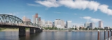
Portland is a city located in the Pacific Northwest
, near the confluence
of the Willamette
and Columbia
rivers in the U.S. state of Oregon
. As of the 2010 Census, it had a population of 583,776, making it the 29th most populous city in the United States. Portland is Oregon's most populous city, and the third most populous city in the Pacific Northwest, after Seattle, Washington and Vancouver
, British Columbia
, Canada
. Approximately 2,260,000 people live in the Portland metropolitan area
(MSA
), the 23rd most populous in the United States.
Portland was incorporated in 1851 and is the county seat
of Multnomah County
. The city extends west into the Cedar Mill
neighborhood in Washington County
and south towards Lake Oswego
in Clackamas County
. With a commission-based government
headed by a mayor and four other commissioners, the city and region are noted for strong land-use planning and investment in light rail
, supported by Metro
, a distinctive regional government. Because of its public transportation networks and efficient land use planning, Portland has been referred to as one of the most environmentally friendly
, or "green", cities in the world.
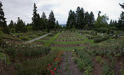
Located in the Marine west coast climate
region, Portland has a climate marked by warm, dry summers and wet but mild winters. This climate is ideal for growing rose
s, and for more than a century, Portland has been known as "The City of Roses" with many rose garden
s—most prominently the International Rose Test Garden
. The city is also known for its large number of microbreweries
and microdistilleries
, as well as its coffee enthusiasm. It is also the home of the Timbers
MLS
team and the Trail Blazers
NBA
team.
and the Cascades Indians settled along the Columbia Gorge. These groups fished and traded along the river and gathered berries, wapato
and other root vegetables. The nearby Tualatin Plains
provided prime hunting grounds.
The later settlement of Portland started as a spot known as "the clearing," which was on the banks of the Willamette about halfway between Oregon City
and Fort Vancouver
. In 1843, William Overton
saw great commercial potential for this land but lacked the funds required to file a land claim. He struck a bargain with his partner, Asa Lovejoy
of Boston, Massachusetts: for 25¢, Overton would share his claim to the 640 acres (2.6 km²) site. Overton later sold his half of the claim to Francis W. Pettygrove of Portland, Maine
. Pettygrove and Lovejoy each wished to name the new city after his respective home town. In 1845, this controversy was settled with a coin toss, which Pettygrove won in a series of two out of three tosses. The coin used for this decision, now known as the Portland Penny
, is on display in the headquarters of the Oregon Historical Society
.
At the time of its incorporation on February 8, 1851 Portland had over 800 inhabitants, a steam sawmill, a log cabin
hotel, and a newspaper, the Weekly Oregonian
. By 1879, the population had grown to 17,500. The city merged with Albina and East Portland in 1891, and annexed the cities of Linnton and St. Johns in 1915.
Portland's location, with access both to the Pacific Ocean via the Willamette and the Columbia rivers and to the agricultural Tualatin Valley
via the "Great Plank Road" through a canyon in the West Hills (the route of current-day U.S. Route 26), gave it an advantage over nearby ports, and it grew very quickly. It remained the major port in the Pacific Northwest for much of the 19th century, until the 1890s, when Seattle's deepwater harbor was connected to the rest of the mainland by rail, affording an inland route without the treacherous navigation of the Columbia River.
, Bridgetown, Rip City, Little Beirut, Beervana or Beertown, P-Town, Soccer City USA, Portlandia, and the metonymous PDX
.
's most populated region, the Willamette Valley
. However, as the metropolitan area is culturally and politically distinct from the rest of the valley, local usage often excludes Portland from the valley proper. Although almost all of Portland lies within Multnomah County
, small portions of the city lie within Clackamas
and Washington
counties with mid-2005 populations estimated at 785 and 1,455, respectively. The Willamette River
runs north through the city center, separating the east and west sections of the city before veering northwest to join with the Columbia River
(which separates the state of Washington from the state of Oregon
) a short distance north of the city.
According to the United States Census Bureau
, the city has a total area of 145.4 square miles (376.6 km²). 134.3 square miles (347.8 km²) of it is land and 11.1 square miles (28.7 km²), or 7.6%, is water.
Portland lies on top of an extinct Plio-Pleistocene volcanic field known as the Boring Lava Field
. The Boring Lava Field includes at least 32 cinder cones such as Mount Tabor
, and its center lies in Southeast Portland. The dormant but potentially active volcano Mount Hood
to the east of Portland is easily visible from much of the city during clear weather. The active volcano Mount Saint Helens to the north in Washington is visible in the distance from high-elevation locations in the city and is close enough to have dusted the city with volcanic ash after an eruption on May 18, 1980. Mount Adams
, another prominent volcano in Washington state to the northeast of Portland, is also visible from parts of the city.
with mild, damp winters and relatively dry, warm summers. Like much of the Pacific Northwest
, according to the Köppen climate classification
it falls within the cool, dry-summer subtropical zone (Csb), also referred to as cool-summer Mediterranean
, because of its relatively dry summers. Other climate classification systems, such as Trewartha, place it firmly in the Oceanic zone (Do).
Summers in Portland are warm, sunny and rather dry, with August, the warmest month, having an average daily high temperature of 79.7 °F (26.5 °C), and much larger day-night variation
than in winter. Because of its inland location and when there is an absence of a sea breeze, heatwaves occur (in particular during the months of July and August) with air temperatures sometimes rising over 100 °F (38 °C), but 90 °F (32 °C) is more commonplace, occurring 13 days per annum. Winters are normally mild, and very moist, with January averaging 39.9 °F (4.4 °C). Lows, though usually above freezing, can reach that mark or below 37 nights per year, however. Cold snaps are short-lived, and snowfall occurs no more than a few times per year, although the city has been known to see major snow and ice storms because of the cold air outflow from the Columbia River Gorge
. The city's winter snowfall totals have ranged from just a trace on many occasions, to 60.9 inches (154.7 cm) in 1892–93. Spring can bring rather unpredictable weather, resulting from warm spells, to thunderstorms rolling off the Cascade Range. The rainfall averages an equivalent 37.5 inches (952.5 mm) per year in downtown Portland, spread over 155 days a year. The lowest temperature ever recorded in Portland was −3 °F, set on February 2, 1950. The highest temperature ever recorded was 107 °F (42 °C), set on July 30, 1965 as well as August 8 and 10, 1981. Temperatures of 100 °F (38 °C) have been recorded in each of the months from May through September.
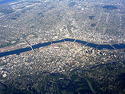
 Portland straddles the Willamette River near its confluence with the Columbia River
. The denser and earlier-developed west side is mostly hemmed in by the nearby West Hills (Tualatin Mountains)
, though it extends over them to the border with Washington County. The flatter east side fans out for about 180 blocks, until it meets the suburb of Gresham
. Rural Multnomah County lies farther east.
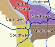
In 1891 the cities of Portland, Albina
, and East Portland
were consolidated, and duplicate street names were given new names. The "great renumbering" on September 2, 1931 standardized street naming patterns, and changed house numbers from 20 per block to 100 per block. It divided Portland into five sections: Southwest, Southeast, Northwest, North, and Northeast. Burnside St. divides north and south, and the Willamette River divides east and west. The river curves west five blocks north of Burnside and in place of it, Williams Ave. is used as a divider. The North section lies between Williams Ave. and the Willamette River to the west.
On the west side, the RiverPlace, John's Landing and South Waterfront Districts lie in a "sixth quadrant" where addresses go higher from west to east toward the river. This "sixth quadrant" is roughly bounded by Naito Parkway and Barbur Boulevard to the west, Montgomery Street to the north and Nevada Street to the south. East-West addresses in this area are denoted with a leading zero (instead of a minus sign). This means 0246 SW California St. is not the same as 246 SW California St. Many mapping programs are unable to distinguish between these two different addresses.
 Portlanders are proud of Portland's parks and its legacy of preserving open spaces. Parks and greenspace planning date back to John Charles Olmsted
's 1903 Report to the Portland Park Board. In 1995, voters in the Portland metropolitan region passed a regional bond measure to acquire valuable natural areas for fish, wildlife, and people. Ten years later, more than 8100 acres (33 km²) of ecologically valuable natural areas had been purchased and permanently protected from development.
Portland is one of only three cities in the contiguous U.S.
with extinct volcanoes within its boundaries (besides Jackson, Mississippi
and Bend, Oregon
). Mount Tabor Park
is known for its scenic views and historic reservoirs.
Forest Park
is the largest wilderness park within city limits in the United States, covering more than 5000 acre (2,023 ha). Portland is also home to Mill Ends Park
, the world's smallest park (a two-foot-diameter circle, the park's area is only about 0.3 square m). Washington Park is just west of downtown, and is home to the Oregon Zoo
, the Portland Japanese Garden
, and the International Rose Test Garden
.
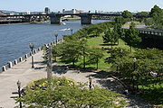
Tom McCall Waterfront Park
runs along the west bank of the Willamette for the length of downtown. The 37 acres (15 ha) park was built in 1974 after Harbor Drive
was removed and now hosts large events throughout the year. Portland's downtown features two groups of contiguous city blocks dedicated for park space: the North
and South Park Blocks
.
Tryon Creek State Natural Area
is one of three Oregon State Parks in Portland and the most popular; its creek has a run of steelhead
. The other two State Parks are Willamette Stone State Heritage Site located in the West Hills and the Government Island State Recreation Area located in the Columbia River
near Portland International Airport
.
has continued to award Portland the title of the Greenest City in America and Grist magazine lists it as the second greenest city in the world. Portland is the home city of "the World's Oldest Teenage Drag Queen Pageant", the Rose Bud and Thorn Pageant, started in 1975 and modeled after the Imperial Sovereign Rose Court of Oregon.
 Like most large cities, Portland has a range of classical performing arts institutions which include the Oregon Ballet Theatre, Oregon Symphony
, Portland Opera
and the Portland Youth Philharmonic
. It also has quite a few stages similar to New York's Off Broadway or Off-Off-Broadway
such as Portland Center Stage
, Artists Repertory Theatre
, Miracle Theatre, Stark Raving Theatre
, and Tears of Joy Theatre
. Portland hosts the world's only HP Lovecraft Film Festival at the Hollywood Theatre.
Portland is home to famous bands such as The Kingsmen
and Paul Revere & the Raiders
, both famous for their associations with the song "Louie Louie
". Other widely known musical groups include The Dandy Warhols
, Everclear
, Modest Mouse
, Pink Martini
, Sleater-Kinney
, The Shins
, Blitzen Trapper
, The Decemberists
, and the late Elliott Smith
. The city's now-demolished Satyricon nightclub
is well known for being the place where the late Nirvana
frontman Kurt Cobain
and Hole
frontwoman Courtney Love
met each other; Love had grown up in Portland for most of her life. In recent years, a number of indie music bands from Portland have been touring nationally.
Widely recognized animators who hail from Portland include Matt Groening
(The Simpsons) , Will Vinton
(Will Vinton's A Claymation Christmas Celebration
) and Travis Knight
(Coraline). Dan Steffan
, cartoonist-illustrator for Heavy Metal
and other magazines, lives in Portland.
Filmmaker Gus Van Sant
(Good Will Hunting
(1997), Milk
(2008)) is also a Portland native. Actors from Portland include Sam Elliott
and Sally Struthers
.
Recent films set and shot in Portland include Extraordinary Measures
, Body of Evidence, What the Bleep Do We Know!?
,The Hunted, Twilight
, Paranoid Park
, Wendy and Lucy
, Feast of Love
, Untraceable
, and Coraline
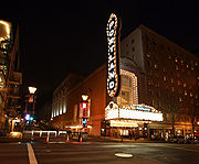
. An unusual feature of Portland entertainment is the large number of movie theaters serving beer, often with second-run or revival films. A notable example of these "brew and view" theaters is The Bagdad Theater and Pub
.
TV shows including Portlandia
, Leverage
, Under Suspicion
, Grimm
, Nowhere Man
and Life Unexpected
have been filmed in Portland.
, famous for her Earthsea
novels, Hainish Cycle and Orsinian Tales
; transgressional fiction novelist Chuck Palahniuk
, best known for his award-winning novel Fight Club
; best-selling Christian author Don Miller
; and Beverly Cleary
, author of the famous series of children's books featuring Henry Huggins
, his dog Ribsy
, Beatrice "Beezus" Quimby and Ramona Quimby
. Klickitat Street
, where Cleary's characters live, is an actual street in northeast Portland. Statues of the characters stand in nearby Grant Park.
Portland is home to a number of independent, small graphic novel publishers such as Dark Horse Comics
and Oni Press
, as well as comic book artists and writers such as Brian Michael Bendis
and Farel Dalrymple
.
The Portland Art Museum
owns the city's largest art collection and presents a variety of touring exhibitions each year. With the recent addition of the Modern and Contemporary Art wing it became one of the United States' twenty-five largest museums. Art galleries abound downtown and in the Pearl District
, as well as in the Alberta Arts District
and other neighborhoods throughout the city.
The Oregon Museum of Science and Industry
(OMSI) is located on the east bank of the Willamette River across from downtown Portland, and contains a variety of hands-on exhibits covering the physical sciences, life science, earth science, technology, astronomy, and early childhood education. OMSI also has an OMNIMAX Theater and is home to the submarine, used in the film The Hunt for Red October
.
Portland is also home to Portland Classical Chinese Garden, an authentic representation of a Suzhou
-style walled garden.
Portlandia
, a statue on the west side of the Portland Building, is the second-largest hammered-copper statue in the U.S. (after the Statue of Liberty). Portland's public art is managed by the Regional Arts & Culture Council
.
Powell's City of Books, whose downtown multistory building at the intersection of Burnside and 10th Street occupies an entire city block, claims to be the largest independent bookstore
in the United States and the largest bookstore west of the Mississippi River. Their specialty computer and science bookstore recently moved into a new location across the street.
The Portland Rose Festival
takes place annually in June and includes two parades, dragon boat
races, carnival rides at Tom McCall Waterfront park, and dozens of other events.
Washington Park, in the West Hills, is home to some of Portland's most popular recreational sites, including the Oregon Zoo
, the Portland Japanese Garden
, the World Forestry Center
, and the Hoyt Arboretum
.
Portland hosts a number of festivals throughout the year in celebration of beer and brewing, including the Oregon Brewers Festival
. Held each summer during the last full weekend of July, it is the largest outdoor craft beer festival in North America with over 70,000 attendees in 2008. Other major beer festivals throughout the calendar year include the Spring Beer and Wine Festival in April, the North American Organic Brewers Festival in June, the Portland International Beerfest in July, and the Holiday Ale Festival in December.
 Portland has many options for shopping. Some of the well known shopping areas are Downtown Portland
, Nob Hill (NW 21st & 23rd Avenues), Pearl District, and the Lloyd District. Major department stores in downtown include Nordstrom
, Macy's
, and Mario's. The major malls in the metropolitan area are Bridgeport Village, Washington Square, Clackamas Town Center
, Lloyd Center
, Vancouver Mall, and Pioneer Place
. Another destination is the Portland Saturday Market
, a town bazaar-like environment where many kinds of goods are sold from Artisan Crafts to Tibetan Imports, reflecting the many cultures of Portland. The Saturday Market is open every weekend from March through Christmas.
beer. Oregon Public Broadcasting has documented Portland's role in the microbrew revolution in the United States in a report called Beervana. Some illustrate Portlanders' interest in the beverage by an offer made in 1888 when local brewer Henry Weinhard
volunteered to pump beer from his brewery into the newly dedicated Skidmore Fountain
. Portland's modern abundance of microbreweries dates to the 1980s when state law was changed to allow consumption of beer on brewery premises. Brewery innovation was supported by the abundance of local ingredients, including two-row barley
, over a dozen varieties of hops
, and pure water from the Bull Run Watershed.
Portland is home to more than 40 breweries—more breweries than any other city in the world—which is partially responsible for CNBC
naming Portland the best city for happy hour in the U.S. The McMenamin brothers
alone have over thirty brewpubs, distilleries, and wineries scattered throughout the metropolitan area, several in renovated cinemas and other historically significant buildings otherwise destined for demolition. Other notable Portland brewers include Widmer Brothers, BridgePort
, and Hair of the Dog, as well as numerous smaller, quality brewers. In 1999, author Michael "Beerhunter" Jackson
called Portland a candidate for the beer capital of the world because the city boasted more breweries than Cologne
, Germany. The Portland Oregon Visitors Association promotes "Beervana" and "Brewtopia" as nicknames for the city. In mid-January 2006, Mayor Tom Potter officially gave the city a new nickname: Beertown.
 The New York Times also spotlighted Portland for its burgeoning restaurant scene in the same year. Travel + Leisure
ranked Portland No. 9 among all national cities in 2007. The city is also known for being the most vegetarian-friendly city in America.
Portland has been named the best city in the world for street food by several publications, including U.S. News and CNN. Food cart pods spread throughout the city have come to define the scene, appearing frequently on television programs & becoming popular destinations themselves.
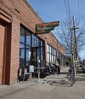
In addition to beer, Portland has become known as a premier coffee destination in the Pacific Northwest. Yelp.com lists more than 20 coffee houses in Portland with 4.5-5 star ratings. The city is home to the original Stumptown Coffee Roasters
, well-known by aficionados as one of the nation's highest quality direct-trade roasteries, as well as dozens of other micro-roasteries and cafes.
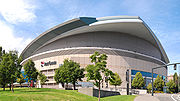 Portland is home to two major league teams: the Portland Timbers
of Major League Soccer
and the Portland Trail Blazers
of the National Basketball Association
. The city is also home to a number of minor league teams.
Running is a popular sport in the metropolitan area, which hosts the Portland Marathon
and much of the Hood to Coast Relay
, the world's largest (by number of participants) long-distance relay race. The city is home to the Oregon Track Club
, which includes American record holders Chris Solinsky
, Alan Webb
, and Shalane Flanagan
. Skiing and snowboarding are also highly popular, with a number of nearby resorts on Mount Hood
, including year-round Timberline Lodge.
Portland was formerly home to the Portland Rosebuds
of the Pacific Coast Hockey Association
, the first professional sports team in Oregon and the first professional hockey team in the United States. The Rosebuds played in the 1916 Stanley Cup Finals
, the first American team to do so.
The city also has one of the most active bicycle racing scenes in the United States. The Oregon Bicycle Racing Association
sanctions hundreds of bicycling events each year. Weekly events at Alpenrose Velodrome and Portland International Raceway
allow for racing nearly every night of the week March through September, and cyclocross races September through December, such as the Cross Crusade
, can have over 1,000 riders and boisterous spectators.
Additionally, the Portland metro area has its own cricket league, the Oregon Cricket League. The league hosts two formats.
Portland has two Division I college sports teams, the University of Portland Pilots and the Portland State Vikings
. Both universities field teams in numerous sports, including soccer, baseball, basketball, and football. The University of Portland plays at Joe Etzel Field, the Clive Charles Soccer Complex, and the Chiles Center. Portland State University plays at the Stott Center and Jeld-Wen Field. In addition, Lewis & Clark College
fields several sports teams that compete in NCAA Division III.
is the only daily general-interest newspaper serving Portland. It also circulates throughout the state and in Clark County, Washington
.
Smaller local newspapers, distributed free of charge in newspaper boxes and at venues around the city, include Portland Tribune
(general-interest paper published on Thursdays), Willamette Week
(general-interest alternative weekly
published on Wednesdays), The Portland Mercury
(another weekly, targeted at younger urban readers published on Thursdays), and The Asian Reporter
(a weekly covering Asian news, both international and local).
Portland Indymedia is one of the oldest and largest Independent Media Centers. The Portland Alliance
, a largely anti-authoritarian progressive monthly, is the largest radical print paper in the city. Just Out
, published in Portland twice monthly, is the region's foremost LGBT
publication. A biweekly paper, Street Roots
, is also sold within the city by members of the homeless community.
The Portland Business Journal
, a weekly, covers business-related news, as does The Daily Journal of Commerce
. Portland Monthly
is a monthly news and culture magazine. The Bee, over 105 years old, is another neighborhood newspaper serving the inner southeast neighborhoods.
Portland is well served by television and radio.
 Portland's location is beneficial for several industries. Relatively low energy cost, accessible resources, North-South and East-West Interstates, international air terminals, large marine shipping facilities, and both west coast intercontinental railroads are all economic advantages. The US consulting firm Mercer
, in a 2009 assessment "conducted to help governments and major companies place employees on international assignments", ranked Portland 42nd worldwide in quality of living
; the survey factored in political stability
, personal freedom, sanitation, crime, housing, the natural environment, recreation, banking facilities, availability of consumer goods, education, and public services including transportation.
The city's history of attracting and retaining company headquarters is mixed. Major businesses such as Willamette Industries, Louisiana-Pacific
, CH2M HILL
, U.S. Bank, and Evraz North American
(formerly known as Oregon Steel Mills
), have moved headquarters out of the city, as have smaller companies such as Lucy Activewear
and Northwest Pipe Company. Examples of how the city has attracted a company's world, North American, or U.S. headquarters include Vestas Wind Systems
, and sporting goods manufacturers Li-Ning Co., Hi-Tec Sports, KEEN, Inc. and Adidas
.
Other Portland based companies include advertising firm Wieden+Kennedy
; financial services companies Umpqua Holdings Corporation
and StanCorp Financial Group; data tracking firm Rentrak
; utility providers PacifiCorp
, NW Natural
and Portland General Electric
; communications provider Integra Telecom
; restaurant chains McMenamins
and McCormick & Schmick's
; toolmaker Leatherman
; and architectural firms ZGF Architects LLP and Boora Architects
.
" law limits the boundaries for large scale development in each metropolitan area in Oregon. This limits access to utilities such as sewage, water and telecommunications, as well as coverage by fire, police and schools. Originally this law mandated that the city must maintain enough land within the boundary to provide an estimated 20 years of growth; however, in 2007 the legislature altered the law to require the maintenance of an estimated 50 years of growth within the boundary, as well as the protection of accompanying farm and rural lands.
The growth boundary, along with efforts of the PDC to create economic development zones, has led to the development of a large portion of downtown, a large number of mid- and high-rise developments, and an overall increase in housing and business density.
. The metro area is home to more than 1,200 technology companies. This high density of technology companies has led to the nickname Silicon Forest
being used to describe the Portland area, a reference to the abundance of trees in the region and to the Silicon Valley
region in Northern California.
Portland is home to the North American headquarters for Adidas
, while the metropolitan area serves as the headquarters for Nike
, FLIR Systems
, Columbia Sportswear
, and TriQuint Semiconductor
, among others. Nike and Portland based Precision Castparts
are the only two Fortune 500
companies headquartered in Oregon. Other manufacturing companies based in Portland include Freightliner Trucks
, Zidell Companies
, The Collins Companies
, while Western Star Trucks
builds their trucks in the city.
The steel industry's history in Portland predates World War II. By the 1950s, the steel industry became the city's number one industry for employment. The steel industry thrives in the region, with Schnitzer Steel Industries
, a prominent steel company, shipping a record 1.15 billion tons of scrap metal to Asia during 2003. Other heavy industry companies include ESCO Corporation
and Oregon Steel Mills
.
The marine terminals alone handle over 13 million tons of cargo per year, and is home to one of the largest commercial dry docks in the country. The Port of Portland
is the third largest U.S. port on the west coast, though it is located about 80 miles (128.7 km) upriver.
 The Portland metropolitan area has transportation services common to major U.S. cities, though Oregon's emphasis on proactive land-use planning
and transit-oriented development
within the urban growth boundary
means that commuters have multiple well-developed options. A 2011 study by Walk Score ranked Portland 12th most walkable of fifty largest U.S. cities.
Some Portlanders use mass transit for their daily commute. In 2008, 12.6% of all commutes in Portland were on public transit. TriMet
operates most of the region's buses and the MAX (short for Metropolitan Area Express) light rail
system, which connects the city and suburbs. Westside Express Service, or WES, opened in February 2009 as commuter rail for Portland's western suburbs, linking Beaverton
and Wilsonville
. The Portland Streetcar
operates from the south waterfront, through Portland State University and north to nearby homes and shopping districts. The Streetcar line will add 3.3 miles of tracks on the east side of the Willamette River in the fall of 2012. The line will complete a loop to the tracks on the west side of the river once the new Portland-Milwaukie Light Rail Bridge is completed in 2013.
Within the Free Rail Zone, a designated geographic area centered in downtown, rides on TriMet's MAX and streetcar systems are free. Fifth and Sixth avenues within downtown comprise the Portland Transit Mall
, two streets devoted primarily to bus and light rail traffic with limited automobile access. Intense public transit development continues as two light rail lines are under construction, as well as a new downtown transit mall linking several transit options. TriMet also provides real-time tracking of buses and trains with its TransitTracker and even makes the data available to software developers so they can create customized tools of their own.
I-5 connects Portland with the Willamette Valley
, Southern Oregon
, and California to the south and with Washington to the north. I-405
forms a loop with I-5 around the central downtown area of the city and I-205
is a loop freeway route on the east side which connects to the Portland International Airport
. US 26 supports commuting within the metro area and continues to the Pacific Ocean westward and Mount Hood
and Central Oregon
eastward. US 30 has a main, bypass, and business route through the city extending to Astoria, Oregon
to the west; through Gresham, Oregon
, and the eastern exurbs
, and connects to I-84, traveling towards Boise, Idaho
.
Portland's main airport is Portland International Airport
, located about 20 minutes by car (40 minutes by MAX) northeast of downtown. In addition Portland is home to Oregon's only public use heliport, the Portland Downtown Heliport
.
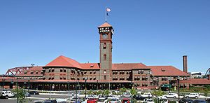
Amtrak
, the national passenger rail system, provides service to Portland at Union Station
on three routes. Long-haul train routes include the Coast Starlight
(with service from Los Angeles to Seattle) and the Empire Builder
(with service from Portland to Chicago.) The Amtrak Cascades
commuter trains operate between Vancouver, British Columbia and Eugene, Oregon
, and serve Portland several times daily.
The city is particularly supportive of urban bicycling and has been recognized by the League of American Bicyclists
among others for its network of on street bicycling facilities and other bicycle-friendly
services.
It ranks highly among the most bicycle friendly cities in the world.
The Bicycle Transportation Alliance
sponsors an annual Bicycle Commute Challenge, in which thousands of commuters compete for prizes and recognition based on the length and frequency of their commutes. Approximately 8% of commuters bike to work, the highest proportion of any major U.S. city and about 10 times the national average.
Car sharing through Zipcar
and U Car Share
is available to residents of the city and some inner suburbs. Portland has a commuter aerial cableway, the Portland Aerial Tram
, which connects the South Waterfront
district on the Willamette River to the Oregon Health & Science University
campus on Marquam Hill above.
Portland has five indoor skatepark
s and is home to historically significant Burnside Skatepark
. Gabriel Skatepark is the most recent, which opened on July 12, 2008. Another fourteen are in the works. The Wall Street Journal
stated Portland "may be the most skateboard-friendly town in America."
 The city of Portland is governed by the Portland City Council, which includes the Mayor, four Commissioners, and an auditor. Each is elected citywide to serve a four year term. The auditor provides checks and balances in the commission form of government and accountability for the use of public resources. In addition, the auditor provides access to information and reports on various matters of city government.
The city's Office of Neighborhood Involvement serves as a conduit between city government and Portland's 95 officially recognized neighborhoods. Each neighborhood is represented by a volunteer-based neighborhood association
which serves as a liaison between residents of the neighborhood and the city government. The city provides funding to neighborhood associations through seven district coalitions, each of which is a geographical groupings of several neighborhood associations. Most (but not all) neighborhood associations belong to one of these district coalitions.
Portland and its surrounding metropolitan area are served by Metro
, the United States' only directly elected metropolitan planning organization
. Metro's charter gives it responsibility for land use
and transportation planning
, solid waste management, and map development. Metro also owns and operates the Oregon Convention Center
, Oregon Zoo
, Portland Center for the Performing Arts
, and Portland Metropolitan Exposition Center
.
The Multnomah County
government provides many services to the Portland area, as do Washington
and Clackamas
counties to the west and south.
Portland strongly favors the Democratic Party
. Although local elections are nonpartisan, most of the city's elected officials are Democrats.
Portland's delegation to the Oregon Legislative Assembly
is entirely Democratic. In the current 76th Oregon Legislative Assembly
, which first convened in 2011, four state Senators represent Portland in the state Senate
: Diane Rosenbaum
(District 21), Chip Shields
(District 22), Jackie Dingfelder
(District 23), and Rod Monroe
(District 24), all Democrats. Portland sends six Representatives to the state House of Representatives
: Jules Bailey (District 42), Lew Frederick
(District 43), Tina Kotek
(District 44), Michael Dembrow
(District 45), Ben Cannon
(District 46), and Jefferson Smith
(District 47), also all Democrats.
Portland's federal representation in the United States House of Representatives
is split between three congressional districts. Most of the city is in the 3rd District
, represented by Earl Blumenauer
, who served on the city council from 1986 until his election to Congress in 1996. Most of the city west of the Willamette River is part of the 1st District
, represented by David Wu
. A small portion of the city is in the 5th District
, represented by Kurt Schrader
. All three are Democrats. A Republican
has not represented a significant portion of Portland in the U.S. House of Representatives since 1975. Both of Oregon's senators, Ron Wyden
and Jeff Merkley
, are from Portland and are also both Democrats.
Sam Adams, the current mayor of Portland, became the city's first openly gay mayor in 2009. In 2004, 59.7 percent of Multnomah County voters cast ballots against Oregon Ballot Measure 36
, which amended the Oregon Constitution
to prohibit recognition of same-sex marriage
s. The measure passed with 56.6% of the statewide vote. Multnomah County is one of two counties where a majority voted against the initiative; the other is Benton County
, which includes Corvallis
, home of Oregon State University
.
On April 28, 2005, Portland became the only city in the nation to withdraw from a Joint Terrorism Task Force
.
 The city consulted with urban planners as far back as 1903. Development of Washington Park and one of the country's finest greenways, the 40 Mile Loop
, which interconnects many of the city's parks, began.
Portland is often cited as an example of a city with strong land use planning
controls; This is largely the result of statewide land conservation policies adopted in 1973 under Governor Tom McCall
, in particular the requirement for an urban growth boundary
(UGB) for every city and metropolitan area. The opposite extreme, a city with few or no controls, is typically illustrated by Houston, Texas.
Portland's urban growth boundary, adopted in 1979, separates urban areas (where high-density development is encouraged and focused) from traditional farm land (where restrictions on non-agricultural development are very strict). This was atypical in an era when automobile use led many areas to neglect their core cities in favor of development along interstate highways, in suburbs, and satellite cities.
The original state rules included a provision for expanding urban growth boundaries, but critics felt this wasn't being accomplished. In 1995, the State passed a law requiring cities to expand UGBs to provide enough undeveloped land for a 20 year supply of future housing at projected growth levels.
The Portland Development Commission
is a semi-public agency that plays a major role in downtown development; it was created by city voters in 1958 to serve as the city's urban renewal
agency. It provides housing and economic development programs within the city, and works behind the scenes with major local developers to create large projects.
In the early 1960s, the PDC led the razing of a large Italian-Jewish neighborhood downtown, bounded roughly by the I-405 freeway, the Willamette River, 4th Avenue and Market street.
Mayor Neil Goldschmidt
took office in 1972 as a proponent of bringing housing and the associated vitality back to the downtown area, which was seen as emptying out after 5 pm. The effort has had dramatic effects in the 30 years since, with many thousands of new housing units clustered in three areas: north of Portland State University (between the I-405 freeway, SW Broadway, and SW Taylor St.); the RiverPlace development along the waterfront under the Marquam (I-5) bridge; and most notably in the Pearl District (between I-405, Burnside St., NW Northrup St., and NW 9th Ave.).
The Urban Greenspaces Institute, housed in Portland State University Geography Department's Center for Mapping Research, promotes better integration of the built and natural environments. The institute works on urban park, trail, and natural areas planning issues, both at the local and regional levels.
In October 2009, the Portland City Council unanimously adopted a climate action plan that will cut the city's greenhouse gas emissions to 80% below 1990 levels by 2050.
According to Grist magazine, Portland is the second most eco-friendly or "green" city in the world trailing only Reykjavík
, Iceland. In 2010, Move, Inc. placed Portland in its "top 10 greenest cities" list.
upheld by the Oregon Supreme Court
Henry v. Oregon Constitution 1987
which specifically found that full nudity and lap dances in strip clubs are protected speech, Portland is widely considered to have more strip clubs per capita than Las Vegas
or San Francisco. Portland has been titled as "Pornland" for its strip clubs, erotic massage
parlors, and high rate of child sex trafficking
. The term was heavily used in 2010, but the term was referenced by Chuck Palahniuk
in 2003.
A judge dismissed charges against a nude bicyclist in November 2008 on the grounds that the city's annual World Naked Bike Ride
"was a well-established tradition in Portland. The first instance occurred sometime around 1999 and had less than 7 participants; at the time it was jokingly referred to as "critical ass" (a play on Critical Mass
bike rides). Participants would 'purchase' a bike from a local chain department store and then return it the next morning. It used to take place at midnight and lasted until the participants were stopped/arrested. The prankster aspect of it came in when the arresting officers didn't want to touch the naked cyclists in order to arrest them. The 2009 Naked Bike Ride occurred without significant incident. City police managed traffic intersections. There were an estimated 3,000 to 5,000 participants. In June 2010 Portland's World Naked Bike Ride had an estimated 13,000 people.
A state law prohibiting publicly insulting a person in a way likely to provoke a violent response was tested in Portland and struck down unanimously by the State Supreme Court as violating protected free speech and being overly broad.
has outpaced the national average during the last decade, with 2008 estimates showing an 80% chance of population growth in excess of 60% over the next 50 years.
Out of 223,737 households, 24.5% have children under the age of 18 living with them, 38.1% are married couples living together, 10.8% have a female householder with no husband present, and 47.1% are non-families. 34.6% of all households are made up of individuals and 9% have someone living alone who is 65 years of age or older. The average household size is 2.3 and the average family size is 3.
The age distribution was 21.1% under the age of 18, 10.3% from 18 to 24, 34.7% from 25 to 44, 22.4% from 45 to 64, and 11.6% who are 65 years of age or older. The median age is 35 years. For every 100 females there are 97.8 males. For every 100 females age 18 and over, there are 95.9 males.
The median income for a household in the city is $40,146, and the median income for a family is $50,271. Males have a reported median income of $35,279 versus $29,344 reported for females. The per capita income for the city is $22,643. 13.1% of the population and 8.5% of families are below the poverty line. Out of the total population, 15.7% of those under the age of 18 and 10.4% of those 65 and older are living below the poverty line. Figures delineating the income levels based on race are not available at this time.
However, though the population of the city is increasing, the total population of children is diminishing, which has put pressure on the public school system to close schools. A 2005 study found that Portland is now educating fewer children than it did in 1925, despite the city's population having almost doubled since then, and the city will have to close the equivalent of three to four elementary schools each year for the next decade.
In 1940, Portland's African-American population was approximately 2,000 and largely consisted of railroad employees and their families. During the war-time liberty ship
construction boom, the need for workers drew many blacks to the city. The new influx of blacks settled in specific neighborhoods, such as the Albina
district and Vanport
. The May 1948 flood which destroyed Vanport
eliminated the only integrated neighborhood, and an influx of blacks into the NE quadrant of the city continued. At 7.90%, Portland's African American population is nearly four times the state average. Over two thirds of Oregon's African-American residents live in Portland. As of the 2000 census, three of its high schools (Cleveland, Lincoln and Wilson) were over 70% white, reflecting the overall population, while Jefferson High School was 87% non-white. The remaining six schools have a higher number of non-whites, including blacks and Asians. Hispanic students average from 3.3% at Wilson to 31% at Roosevelt
.
With about 12,000 Vietnamese residing in the city proper, Portland has one of the largest Vietnamese populations in America per capita. According to statistics there are 21,000 Pacific Islanders in Portland, making up 4% of the population.
The city of Portland has the 7th highest LGBT
population in the country, with 8.8% of residents identifying as homosexual, and the metro area ranks 4th in the nation at 6.1%.
. In 2009, Portland had the fifth-highest percentage of white residents among the 40 largest U.S. metropolitan areas. A 2007 survey of the 40 largest cities in the U.S. concluded that Portland's urban core is the "whitest big city in the nation". Some scholars have noted the Pacific Northwest as a whole is "one of the last Caucasian bastions of the United States". While Portland's diversity was historically comparable to metro Seattle and Salt Lake City, those areas grew more diverse in the late 1990s and 2000s. Portland not only remains white, but migration to Portland is disproportionately white, at least partly because Portland is attractive to young college-educated Americans, a group which is overwhelmingly white.
The racial demographics today are largely a result of historic policies and trends. The Oregon Territory banned African American immigration in 1849. In the 19th century, certain laws allowed the immigration of Chinese laborers but prohibited them from owning property or bringing their families. The early 1920s saw the rapid growth of the Ku Klux Klan
, which became very influential in Oregon politics, culminating in the election of Walter M. Pierce
as governor.
The largest influxes of minority populations occurred during World War II, as the African American population grew 10 times for wartime work. After World War II, the Vanport flood in 1948 displaced many African Americans. As they resettled, redlining
directed the displaced workers from the wartime settlement to neighboring Albina
. There and elsewhere in the Portland area, they experienced police hostility, lack of employment, and mortgage discrimination, leading to half the black population leaving after the war. Widespread housing discrimination continues to affect the racial landscape today. A 2011 audit of landlords' renting practices by the Fair Housing Council of Oregon indicated that 64% of 50 leasing agents discriminated against Latino or black prospective tenants, compared with white prospective tenants. The Oregonian
stated, "They were quoted higher rent and deposits, for example, or given additional fees, not offered applications or move-in specials, or shown inferior units."
In the 1980s and 1990s, radical skinhead groups flourished in Portland. During redevelopment of north Portland along the MAX Yellow Line
, displacement of minorities occurred at a drastic rate. Out of 29 census tracts in north and northeast Portland, ten were majority nonwhite in 2000. By 2010, none of these tracts were majority nonwhite as gentrification
drove the cost of living up. However, Portland's African-American community still thrives in the north and northeast section of the city, mainly in the King Neighborhood.
, Portland State University
, and Oregon Health & Science University
. The city is also home to such private universities as the University of Portland
, Reed College
, and Lewis & Clark College
.
(OMSI), which includes many hands on activities for adults and children. OMSI consists of five main halls, most of which, consist of smaller laboratories: Earth Science Hall, Life Science Hall, Turbine Hall, Science Playground, and Featured Exhibit Hall. The Featured Exhibit Hall has a new exhibit every few months. The laboratories are Chemistry, Physics, Technology, Life, Paleontology, and Watershed. OMSI has many other unique attractions, such as the USS Blueback (SS-581)
, the OMNIMAX Dome Theater, and OMSI's Kendall Planetarium. The USS Blueback was the last non-nuclear fast attack submarine to join the US Navy and OMSI offers daily tours. The OMNIMAX Dome Theater is a variant of the IMAX
motion picture format, where the movie is projected onto a domed projection surface. The projection surface at OMSI's OMNIMAX Dome Theater is 6532 sq ft (606.8 m²). The OMNIMAX Theater uses the largest frame in the motion picture industry and the frames are ten times the size of the standard 35mm film. OMSI's Kendall Planetarium is the largest and most technologically advanced planetarium in the Pacific Northwest. OMSI is located at 1945 SE Water Ave. OMSI is built right up next to the river and is also conveniently located near the entrance to the Springwater Corridor and Eastbank Esplanade pedestrian and bike trails.
owns the city's largest art collection and presents a variety of touring exhibitions each year and with the recent addition of the Modern and Contemporary Art wing it became one of the United States' twenty-five largest museums.
Woods Apartments are the most dangerous areas of the city. In October, 2009, the Forbes magazine rated Portland as the third safest city in America.
Portland also has a "Friendship City" relationship with: Tallinn
, Estonia
Portland websites that are also wiki
s
Pacific Northwest
The Pacific Northwest is a region in northwestern North America, bounded by the Pacific Ocean to the west and, loosely, by the Rocky Mountains on the east. Definitions of the region vary and there is no commonly agreed upon boundary, even among Pacific Northwesterners. A common concept of the...
, near the confluence
Confluence
Confluence, in geography, describes the meeting of two or more bodies of water.Confluence may also refer to:* Confluence , a property of term rewriting systems...
of the Willamette
Willamette River
The Willamette River is a major tributary of the Columbia River, accounting for 12 to 15 percent of the Columbia's flow. The Willamette's main stem is long, lying entirely in northwestern Oregon in the United States...
and Columbia
Columbia River
The Columbia River is the largest river in the Pacific Northwest region of North America. The river rises in the Rocky Mountains of British Columbia, Canada, flows northwest and then south into the U.S. state of Washington, then turns west to form most of the border between Washington and the state...
rivers in the U.S. state of Oregon
Oregon
Oregon is a state in the Pacific Northwest region of the United States. It is located on the Pacific coast, with Washington to the north, California to the south, Nevada on the southeast and Idaho to the east. The Columbia and Snake rivers delineate much of Oregon's northern and eastern...
. As of the 2010 Census, it had a population of 583,776, making it the 29th most populous city in the United States. Portland is Oregon's most populous city, and the third most populous city in the Pacific Northwest, after Seattle, Washington and Vancouver
Vancouver
Vancouver is a coastal seaport city on the mainland of British Columbia, Canada. It is the hub of Greater Vancouver, which, with over 2.3 million residents, is the third most populous metropolitan area in the country,...
, British Columbia
British Columbia
British Columbia is the westernmost of Canada's provinces and is known for its natural beauty, as reflected in its Latin motto, Splendor sine occasu . Its name was chosen by Queen Victoria in 1858...
, Canada
Canada
Canada is a North American country consisting of ten provinces and three territories. Located in the northern part of the continent, it extends from the Atlantic Ocean in the east to the Pacific Ocean in the west, and northward into the Arctic Ocean...
. Approximately 2,260,000 people live in the Portland metropolitan area
Portland metropolitan area
The Portland-Vancouver-Hillsboro, OR-WA Metropolitan Statistical Area , also known as the Portland metropolitan area or Greater Portland, is an urban area in the U.S. states of Oregon and Washington centered around the city of Portland, Oregon. The U.S...
(MSA
United States metropolitan area
In the United States a metropolitan statistical area is a geographical region with a relatively high population density at its core and close economic ties throughout the area. Such regions are not legally incorporated as a city or town would be, nor are they legal administrative divisions like...
), the 23rd most populous in the United States.
Portland was incorporated in 1851 and is the county seat
County seat
A county seat is an administrative center, or seat of government, for a county or civil parish. The term is primarily used in the United States....
of Multnomah County
Multnomah County, Oregon
Multnomah County is one of 36 counties in the U.S. state of Oregon. Though smallest in area, it is the most populous as its county seat, Portland, is the state's largest city...
. The city extends west into the Cedar Mill
Cedar Mill, Oregon
Cedar Mill is a census-designated place and an unincorporated community in Washington County, Oregon, mostly north of U.S. Route 26 and west of the Willamette Stone...
neighborhood in Washington County
Washington County, Oregon
- Major highways :* Interstate 5* Interstate 205* U.S. Route 26* Oregon Route 6* Oregon Route 8* Oregon Route 10* Oregon Route 47* Oregon Route 99W* Oregon Route 210* Oregon Route 217* Oregon Route 219-Demographics:...
and south towards Lake Oswego
Lake Oswego, Oregon
Lake Oswego is a city located primarily in Clackamas County in the U.S. state of Oregon. Small portions of the city are also located in neighboring Multnomah and Washington counties. Located south of Portland surrounding the Oswego Lake, the town was founded in 1847 and incorporated as Oswego in...
in Clackamas County
Clackamas County, Oregon
Clackamas County is a county located in the U.S. state of Oregon. The county was named after the Native Americans living in the area, the Clackamas Indians, who were part of the Chinookan people. As of 2010, the population was 375,992...
. With a commission-based government
City commission government
City commission government is a form of municipal government which once was common in the United States, but many cities which were formerly governed by commission have since switched to the council-manager form of government...
headed by a mayor and four other commissioners, the city and region are noted for strong land-use planning and investment in light rail
Light rail
Light rail or light rail transit is a form of urban rail public transportation that generally has a lower capacity and lower speed than heavy rail and metro systems, but higher capacity and higher speed than traditional street-running tram systems...
, supported by Metro
Metro (Oregon regional government)
Metro, formerly known as Metropolitan Service District, is the regional governmental agency for the Oregon portion of the Portland metropolitan area...
, a distinctive regional government. Because of its public transportation networks and efficient land use planning, Portland has been referred to as one of the most environmentally friendly
Environmentally friendly
Environmentally friendly are terms used to refer to goods and services, laws, guidelines and policies claimed to inflict minimal or no harm on the environment....
, or "green", cities in the world.
Located in the Marine west coast climate
Climate
Climate encompasses the statistics of temperature, humidity, atmospheric pressure, wind, rainfall, atmospheric particle count and other meteorological elemental measurements in a given region over long periods...
region, Portland has a climate marked by warm, dry summers and wet but mild winters. This climate is ideal for growing rose
Rose
A rose is a woody perennial of the genus Rosa, within the family Rosaceae. There are over 100 species. They form a group of erect shrubs, and climbing or trailing plants, with stems that are often armed with sharp prickles. Flowers are large and showy, in colours ranging from white through yellows...
s, and for more than a century, Portland has been known as "The City of Roses" with many rose garden
Rose garden
A Rose garden or Rosarium is a garden or park, often open to the public, used to present and grow various types of garden roses. Designs vary tremendously and roses may be displayed alongside other plants or grouped by individual variety, colour or class in rose beds.-Origins of the rose...
s—most prominently the International Rose Test Garden
International Rose Test Garden
The International Rose Test Garden is a rose garden in Washington Park in Portland, Oregon, United States. There are over 7,000 rose plants of approximately 550 varieties. The roses bloom from April through October with the peak coming in June, depending on the weather...
. The city is also known for its large number of microbreweries
Microbrewery
A microbrewery or craft brewer is a brewery which produces a limited amount of beer, and is associated by consumers with innovation and uniqueness....
and microdistilleries
Microdistillery
A microdistillery is a small, often 'boutique', distillery established to produce beverage grade alcohol in relatively small quantities. While the term is most commonly used in the United States, micro-distilleries have been established in Europe for many years, either as small cognac distilleries...
, as well as its coffee enthusiasm. It is also the home of the Timbers
Portland Timbers
Portland Timbers may refer to any of four distinct professional soccer teams:*Portland Timbers, a Major League Soccer expansion team that began playing in 2011....
MLS
Major League Soccer
Major League Soccer is a professional soccer league based in the United States and sanctioned by the United States Soccer Federation . The league is composed of 19 teams — 16 in the U.S. and 3 in Canada...
team and the Trail Blazers
Portland Trail Blazers
The Portland Trail Blazers, commonly known as the Blazers, are an American professional basketball team based in Portland, Oregon. They play in the Northwest Division of the Western Conference in the National Basketball Association . The Trail Blazers originally played their home games in the...
NBA
National Basketball Association
The National Basketball Association is the pre-eminent men's professional basketball league in North America. It consists of thirty franchised member clubs, of which twenty-nine are located in the United States and one in Canada...
team.
History
The land today occupied by Multnomah County was inhabited for centuries by two bands of Upper Chinook Indians. The Multnomah people settled on and around Sauvie IslandSauvie Island
Sauvie Island, in the U.S. state of Oregon, originally Wapato Island or Wappatoo Island, is the largest island along the Columbia River, at 26,000 acres , and the largest river island in the United States...
and the Cascades Indians settled along the Columbia Gorge. These groups fished and traded along the river and gathered berries, wapato
Sagittaria
Sagittaria is a genus of about 30 species of aquatic plants whose members go by a variety of common names, including arrowhead, duck potato, iz-ze-kn, katniss, kuwai , swan potato, tule potato, and wapato...
and other root vegetables. The nearby Tualatin Plains
Tualatin Plains
The Tualatin Plains are a prairie area in central Washington County, Oregon, United States. Located around the Hillsboro and Forest Grove areas, the plains were first inhabited by the Atfalati band of the Kalapuya group of Native Americans. Euro-American settlement began in the...
provided prime hunting grounds.
The later settlement of Portland started as a spot known as "the clearing," which was on the banks of the Willamette about halfway between Oregon City
Oregon City, Oregon
Oregon City was the first city in the United States west of the Rocky Mountains to be incorporated. It is the county seat of Clackamas County, Oregon...
and Fort Vancouver
Fort Vancouver
Fort Vancouver was a 19th century fur trading outpost along the Columbia River that served as the headquarters of the Hudson's Bay Company in the company's Columbia District...
. In 1843, William Overton
William Overton (Portland founder)
William Overton was a pioneer of the Oregon Country in the Pacific Northwest region of North America. In the mid-1840s he purchased the land claim, along with Asa Lovejoy, for the site which would become Portland, Oregon. Overton sold his share shortly thereafter to Francis Pettygrove.According to...
saw great commercial potential for this land but lacked the funds required to file a land claim. He struck a bargain with his partner, Asa Lovejoy
Asa Lovejoy
Asa Lawrence Lovejoy was an American pioneer and politician in the region that would become the U.S. state of Oregon. He is best remembered as a founder of the city of Portland, Oregon...
of Boston, Massachusetts: for 25¢, Overton would share his claim to the 640 acres (2.6 km²) site. Overton later sold his half of the claim to Francis W. Pettygrove of Portland, Maine
Portland, Maine
Portland is the largest city in Maine and is the county seat of Cumberland County. The 2010 city population was 66,194, growing 3 percent since the census of 2000...
. Pettygrove and Lovejoy each wished to name the new city after his respective home town. In 1845, this controversy was settled with a coin toss, which Pettygrove won in a series of two out of three tosses. The coin used for this decision, now known as the Portland Penny
Portland Penny
The Portland Penny is the name subsequently given to a specific coin, a U.S. copper one-cent piece, used to decide the name of Portland, Oregon, United States...
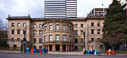
, is on display in the headquarters of the Oregon Historical Society
Oregon Historical Society
The Oregon Historical Society is an organization that encourages and promotes the study and understanding of the history of the Oregon Country, within the broader context of U.S. history. Incorporated in 1898, the Society collects, preserves, and makes available materials of historical character...
.
At the time of its incorporation on February 8, 1851 Portland had over 800 inhabitants, a steam sawmill, a log cabin
Log cabin
A log cabin is a house built from logs. It is a fairly simple type of log house. A distinction should be drawn between the traditional meanings of "log cabin" and "log house." Historically most "Log cabins" were a simple one- or 1½-story structures, somewhat impermanent, and less finished or less...
hotel, and a newspaper, the Weekly Oregonian
The Oregonian
The Oregonian is the major daily newspaper in Portland, Oregon, owned by Advance Publications. It is the oldest continuously published newspaper on the U.S. west coast, founded as a weekly by Thomas J. Dryer on December 4, 1850...
. By 1879, the population had grown to 17,500. The city merged with Albina and East Portland in 1891, and annexed the cities of Linnton and St. Johns in 1915.
Portland's location, with access both to the Pacific Ocean via the Willamette and the Columbia rivers and to the agricultural Tualatin Valley
Tualatin Valley
The Tualatin Valley is a farming and suburban region southwest of Portland, Oregon in the United States. The valley is formed by the meandering Tualatin River, a tributary of the Willamette River at the northwest corner of the Willamette Valley, east of the Northern Oregon Coast Range...
via the "Great Plank Road" through a canyon in the West Hills (the route of current-day U.S. Route 26), gave it an advantage over nearby ports, and it grew very quickly. It remained the major port in the Pacific Northwest for much of the 19th century, until the 1890s, when Seattle's deepwater harbor was connected to the rest of the mainland by rail, affording an inland route without the treacherous navigation of the Columbia River.
Nicknames
The most common nickname for Portland is The City of Roses, and this became the city's official nickname in 2003. Other nicknames include the City of Bridges, StumptownStumptown
Stumptown is a name or nickname that has been applied to several places in the United States :*Guerneville, California is the site of an ancient coast redwood forest, much of which was logged for the rebuilding of San Francisco after the 1906 earthquake and fire...
, Bridgetown, Rip City, Little Beirut, Beervana or Beertown, P-Town, Soccer City USA, Portlandia, and the metonymous PDX
Portland International Airport
Portland International Airport is a joint civil-military airport and the largest airport in the U.S. state of Oregon, accounting for 90% of passenger travel and more than 95% of air cargo of the state. It is located within Portland's city limits just south of the Columbia River in Multnomah...
.
Geography
Topography
Portland lies at the northern end of OregonOregon
Oregon is a state in the Pacific Northwest region of the United States. It is located on the Pacific coast, with Washington to the north, California to the south, Nevada on the southeast and Idaho to the east. The Columbia and Snake rivers delineate much of Oregon's northern and eastern...
's most populated region, the Willamette Valley
Willamette Valley
The Willamette Valley is the most populated region in the state of Oregon of the United States. Located in the state's northwest, the region is surrounded by tall mountain ranges to the east, west and south and the valley's floor is broad, flat and fertile because of Ice Age conditions...
. However, as the metropolitan area is culturally and politically distinct from the rest of the valley, local usage often excludes Portland from the valley proper. Although almost all of Portland lies within Multnomah County
Multnomah County, Oregon
Multnomah County is one of 36 counties in the U.S. state of Oregon. Though smallest in area, it is the most populous as its county seat, Portland, is the state's largest city...
, small portions of the city lie within Clackamas
Clackamas County, Oregon
Clackamas County is a county located in the U.S. state of Oregon. The county was named after the Native Americans living in the area, the Clackamas Indians, who were part of the Chinookan people. As of 2010, the population was 375,992...
and Washington
Washington County, Oregon
- Major highways :* Interstate 5* Interstate 205* U.S. Route 26* Oregon Route 6* Oregon Route 8* Oregon Route 10* Oregon Route 47* Oregon Route 99W* Oregon Route 210* Oregon Route 217* Oregon Route 219-Demographics:...
counties with mid-2005 populations estimated at 785 and 1,455, respectively. The Willamette River
Willamette River
The Willamette River is a major tributary of the Columbia River, accounting for 12 to 15 percent of the Columbia's flow. The Willamette's main stem is long, lying entirely in northwestern Oregon in the United States...
runs north through the city center, separating the east and west sections of the city before veering northwest to join with the Columbia River
Columbia River
The Columbia River is the largest river in the Pacific Northwest region of North America. The river rises in the Rocky Mountains of British Columbia, Canada, flows northwest and then south into the U.S. state of Washington, then turns west to form most of the border between Washington and the state...
(which separates the state of Washington from the state of Oregon
Oregon
Oregon is a state in the Pacific Northwest region of the United States. It is located on the Pacific coast, with Washington to the north, California to the south, Nevada on the southeast and Idaho to the east. The Columbia and Snake rivers delineate much of Oregon's northern and eastern...
) a short distance north of the city.
According to the United States Census Bureau
United States Census Bureau
The United States Census Bureau is the government agency that is responsible for the United States Census. It also gathers other national demographic and economic data...
, the city has a total area of 145.4 square miles (376.6 km²). 134.3 square miles (347.8 km²) of it is land and 11.1 square miles (28.7 km²), or 7.6%, is water.
Portland lies on top of an extinct Plio-Pleistocene volcanic field known as the Boring Lava Field
Boring Lava Field
The Boring Lava Field is an extinct Plio-Pleistocene volcanic field zone with at least 32 cinder cones and small shield volcanoes lying within a radius of 13 miles of Kelly Butte, which is approximately 4 miles east of downtown Portland, Oregon, in the United States...
. The Boring Lava Field includes at least 32 cinder cones such as Mount Tabor
Mount Tabor, Portland, Oregon
Mount Tabor is the name of a volcanic cinder cone, the city park on the volcano, and the neighborhood of Southeast Portland that surrounds it, all in the U.S. state of Oregon. The name refers to Mount Tabor, Israel. It was named by Plympton Kelly, son of Oregon City pioneer resident Clinton...
, and its center lies in Southeast Portland. The dormant but potentially active volcano Mount Hood
Mount Hood
Mount Hood, called Wy'east by the Multnomah tribe, is a stratovolcano in the Cascade Volcanic Arc of northern Oregon. It was formed by a subduction zone and rests in the Pacific Northwest region of the United States...
to the east of Portland is easily visible from much of the city during clear weather. The active volcano Mount Saint Helens to the north in Washington is visible in the distance from high-elevation locations in the city and is close enough to have dusted the city with volcanic ash after an eruption on May 18, 1980. Mount Adams
Mount Adams (Washington)
Mount Adams is a potentially activestratovolcano in the Cascade Range and the second-highest mountain in the U.S. state of Washington.Adams is a member of the Cascade Volcanic Arc, and is one of the arc's largest volcanoes,...
, another prominent volcano in Washington state to the northeast of Portland, is also visible from parts of the city.
Climate
Portland experiences a temperate climate that is usually described as oceanicOceanic climate
An oceanic climate, also called marine west coast climate, maritime climate, Cascadian climate and British climate for Köppen climate classification Cfb and subtropical highland for Köppen Cfb or Cwb, is a type of climate typically found along the west coasts at the middle latitudes of some of the...
with mild, damp winters and relatively dry, warm summers. Like much of the Pacific Northwest
Pacific Northwest
The Pacific Northwest is a region in northwestern North America, bounded by the Pacific Ocean to the west and, loosely, by the Rocky Mountains on the east. Definitions of the region vary and there is no commonly agreed upon boundary, even among Pacific Northwesterners. A common concept of the...
, according to the Köppen climate classification
Köppen climate classification
The Köppen climate classification is one of the most widely used climate classification systems. It was first published by Crimea German climatologist Wladimir Köppen in 1884, with several later modifications by Köppen himself, notably in 1918 and 1936...
it falls within the cool, dry-summer subtropical zone (Csb), also referred to as cool-summer Mediterranean
Mediterranean climate
A Mediterranean climate is the climate typical of most of the lands in the Mediterranean Basin, and is a particular variety of subtropical climate...
, because of its relatively dry summers. Other climate classification systems, such as Trewartha, place it firmly in the Oceanic zone (Do).
Summers in Portland are warm, sunny and rather dry, with August, the warmest month, having an average daily high temperature of 79.7 °F (26.5 °C), and much larger day-night variation
Diurnal temperature variation
Diurnal temperature variation is a meteorological term that relates to the variation in temperature that occurs from the highs of the day to the cool of nights.-Temperature lag:Temperature lag is an important factor in diurnal temperature variation...
than in winter. Because of its inland location and when there is an absence of a sea breeze, heatwaves occur (in particular during the months of July and August) with air temperatures sometimes rising over 100 °F (38 °C), but 90 °F (32 °C) is more commonplace, occurring 13 days per annum. Winters are normally mild, and very moist, with January averaging 39.9 °F (4.4 °C). Lows, though usually above freezing, can reach that mark or below 37 nights per year, however. Cold snaps are short-lived, and snowfall occurs no more than a few times per year, although the city has been known to see major snow and ice storms because of the cold air outflow from the Columbia River Gorge
Columbia River Gorge
The Columbia River Gorge is a canyon of the Columbia River in the Pacific Northwest of the United States. Up to deep, the canyon stretches for over as the river winds westward through the Cascade Range forming the boundary between the State of Washington to the north and Oregon to the south...
. The city's winter snowfall totals have ranged from just a trace on many occasions, to 60.9 inches (154.7 cm) in 1892–93. Spring can bring rather unpredictable weather, resulting from warm spells, to thunderstorms rolling off the Cascade Range. The rainfall averages an equivalent 37.5 inches (952.5 mm) per year in downtown Portland, spread over 155 days a year. The lowest temperature ever recorded in Portland was −3 °F, set on February 2, 1950. The highest temperature ever recorded was 107 °F (42 °C), set on July 30, 1965 as well as August 8 and 10, 1981. Temperatures of 100 °F (38 °C) have been recorded in each of the months from May through September.
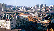
Cityscape
Columbia River
The Columbia River is the largest river in the Pacific Northwest region of North America. The river rises in the Rocky Mountains of British Columbia, Canada, flows northwest and then south into the U.S. state of Washington, then turns west to form most of the border between Washington and the state...
. The denser and earlier-developed west side is mostly hemmed in by the nearby West Hills (Tualatin Mountains)
Tualatin Mountains
The Tualatin Mountains are a range of hills on the western border of Multnomah County, Oregon, United States...
, though it extends over them to the border with Washington County. The flatter east side fans out for about 180 blocks, until it meets the suburb of Gresham
Gresham, Oregon
- Demographics :As of the census of 2000, there were 90,205 people, 33,327 households, and 22,695 families residing in the city. The population density was 4,071.6 people per square mile . There were 35,309 housing units at an average density of 1,593.8 per square mile...
. Rural Multnomah County lies farther east.
In 1891 the cities of Portland, Albina
Albina, Oregon
Albina is a historical city which was consolidated into Portland, Oregon in 1891.Albina was laid out in 1872 with a plat for the new town filed in April 1873 by Edwin Russell, William Page, and George Williams. Albina was named after Mrs. Albina Page, the wife of William Page. Settlement began in...
, and East Portland
East Portland, Oregon
East Portland was a city in the U.S. state of Oregon that was consolidated into Portland in 1891. It was founded on a land claim by James B. Stephens in 1846, who bought a land claim from John McLoughlin of the Hudson's Bay Company...
were consolidated, and duplicate street names were given new names. The "great renumbering" on September 2, 1931 standardized street naming patterns, and changed house numbers from 20 per block to 100 per block. It divided Portland into five sections: Southwest, Southeast, Northwest, North, and Northeast. Burnside St. divides north and south, and the Willamette River divides east and west. The river curves west five blocks north of Burnside and in place of it, Williams Ave. is used as a divider. The North section lies between Williams Ave. and the Willamette River to the west.
On the west side, the RiverPlace, John's Landing and South Waterfront Districts lie in a "sixth quadrant" where addresses go higher from west to east toward the river. This "sixth quadrant" is roughly bounded by Naito Parkway and Barbur Boulevard to the west, Montgomery Street to the north and Nevada Street to the south. East-West addresses in this area are denoted with a leading zero (instead of a minus sign). This means 0246 SW California St. is not the same as 246 SW California St. Many mapping programs are unable to distinguish between these two different addresses.
Parks and gardens
John Charles Olmsted
John Charles Olmsted , the nephew and adopted son of Frederick Law Olmsted, was an American landscape architect. With his brother, Frederick Law Olmsted, Jr., he founded Olmsted Brothers, a landscape design firm in Brookline, Massachusetts. The firm is famous for designing many urban parks,...
's 1903 Report to the Portland Park Board. In 1995, voters in the Portland metropolitan region passed a regional bond measure to acquire valuable natural areas for fish, wildlife, and people. Ten years later, more than 8100 acres (33 km²) of ecologically valuable natural areas had been purchased and permanently protected from development.
Portland is one of only three cities in the contiguous U.S.
Contiguous United States
The contiguous United States are the 48 U.S. states on the continent of North America that are south of Canada and north of Mexico, plus the District of Columbia....
with extinct volcanoes within its boundaries (besides Jackson, Mississippi
Jackson, Mississippi
Jackson is the capital and the most populous city of the US state of Mississippi. It is one of two county seats of Hinds County ,. The population of the city declined from 184,256 at the 2000 census to 173,514 at the 2010 census...
and Bend, Oregon
Bend, Oregon
Bend is a city in and the county seat of Deschutes County, Oregon, United States, and the principal city of the Bend, Oregon Metropolitan Statistical Area. Bend is Central Oregon's largest city, and, despite its modest size, is the de facto metropolis of the region, owing to the low population...
). Mount Tabor Park
Mount Tabor, Portland, Oregon
Mount Tabor is the name of a volcanic cinder cone, the city park on the volcano, and the neighborhood of Southeast Portland that surrounds it, all in the U.S. state of Oregon. The name refers to Mount Tabor, Israel. It was named by Plympton Kelly, son of Oregon City pioneer resident Clinton...
is known for its scenic views and historic reservoirs.
Forest Park
Forest Park (Portland)
Forest Park is a public municipal park in the Tualatin Mountains west of downtown Portland, Oregon, United States. Stretching for more than on hillsides overlooking the Willamette River, it is one of the country's largest urban forest reserves...
is the largest wilderness park within city limits in the United States, covering more than 5000 acre (2,023 ha). Portland is also home to Mill Ends Park
Mill Ends Park
Mill Ends Park is a tiny urban park located in the median strip of SW Naito Parkway, approaching esplanade along the Willamette River near SW Taylor Street in downtown Portland, Oregon, United States. The park is a circle across, with a total area of...
, the world's smallest park (a two-foot-diameter circle, the park's area is only about 0.3 square m). Washington Park is just west of downtown, and is home to the Oregon Zoo
Oregon Zoo
The Oregon Zoo, formerly the Washington Park Zoo, is a zoo in Portland, the largest city in the U.S. state of Oregon. Located southwest of Downtown Portland, the zoo is inside Portland's Washington Park, and includes a narrow-gauge railway that connects to the International Rose Test Garden inside...
, the Portland Japanese Garden
Portland Japanese Garden
The Portland Japanese Garden is a traditional Japanese garden occupying 5.5 acres , located within Washington Park in the west hills of Portland, Oregon, USA.- Design :...
, and the International Rose Test Garden
International Rose Test Garden
The International Rose Test Garden is a rose garden in Washington Park in Portland, Oregon, United States. There are over 7,000 rose plants of approximately 550 varieties. The roses bloom from April through October with the peak coming in June, depending on the weather...
.
Tom McCall Waterfront Park
Tom McCall Waterfront Park
Governor Tom McCall Waterfront Park is a park located on the west bank of the Willamette River in downtown Portland, Oregon. It is , comprising 16 tax lots owned by the City of Portland....
runs along the west bank of the Willamette for the length of downtown. The 37 acres (15 ha) park was built in 1974 after Harbor Drive
Harbor Drive
Harbor Drive is the name of a street in Portland, Oregon, which was formerly a freeway that carried U.S. Route 99W along the western shore of the Willamette River in the downtown area...
was removed and now hosts large events throughout the year. Portland's downtown features two groups of contiguous city blocks dedicated for park space: the North
North Park Blocks
The North Park Blocks form a city park in downtown Portland, Oregon.Captain John H. Couch deeded the five blocks to the city in 1865, probably officially platted and dedicated to the city in 1869. An ordinance was passed in 1904, setting aside one park block for women and children. In 1906, another...
and South Park Blocks
South Park Blocks
The South Park Blocks form a city park in downtown Portland, Oregon. The Oregonian has called it Portland's "extended family room", as Pioneer Courthouse Square is known as Portland's "living room"....
.
Tryon Creek State Natural Area
Tryon Creek State Natural Area
The Tryon Creek State Natural Area is a state park located primarily in Portland, in the U.S. state of Oregon. It is the only Oregon state park within a major metropolitan area...
is one of three Oregon State Parks in Portland and the most popular; its creek has a run of steelhead
Rainbow trout
The rainbow trout is a species of salmonid native to tributaries of the Pacific Ocean in Asia and North America. The steelhead is a sea run rainbow trout usually returning to freshwater to spawn after 2 to 3 years at sea. In other words, rainbow trout and steelhead trout are the same species....
. The other two State Parks are Willamette Stone State Heritage Site located in the West Hills and the Government Island State Recreation Area located in the Columbia River
Columbia River
The Columbia River is the largest river in the Pacific Northwest region of North America. The river rises in the Rocky Mountains of British Columbia, Canada, flows northwest and then south into the U.S. state of Washington, then turns west to form most of the border between Washington and the state...
near Portland International Airport
Portland International Airport
Portland International Airport is a joint civil-military airport and the largest airport in the U.S. state of Oregon, accounting for 90% of passenger travel and more than 95% of air cargo of the state. It is located within Portland's city limits just south of the Columbia River in Multnomah...
.
Culture and contemporary life
Portland is often awarded the "Greenest City in America", and ranks among the world's top 10 greenest cities. Popular SciencePopular Science
Popular Science is an American monthly magazine founded in 1872 carrying articles for the general reader on science and technology subjects. Popular Science has won over 58 awards, including the ASME awards for its journalistic excellence in both 2003 and 2004...
has continued to award Portland the title of the Greenest City in America and Grist magazine lists it as the second greenest city in the world. Portland is the home city of "the World's Oldest Teenage Drag Queen Pageant", the Rose Bud and Thorn Pageant, started in 1975 and modeled after the Imperial Sovereign Rose Court of Oregon.
Entertainment and performing arts
Oregon Symphony
The Oregon Symphony is an American orchestra based in Portland, Oregon. Founded as the Portland Symphony Society in 1896, it is the sixth oldest orchestra in the United States, and oldest in the Western United States...
, Portland Opera
Portland Opera
Portland Opera is an American opera company based at The Hampton Opera Center in Portland, Oregon. Its mainstage performances take place in the Keller Auditorium, while the Portland Opera Studio Theater at the Hampton center is used for performances of chamber operas...
and the Portland Youth Philharmonic
Portland Youth Philharmonic
The Portland Youth Philharmonic is the oldest youth orchestra in the United States, established in 1924 as the Portland Junior Symphony . Now based in Portland, Oregon, the orchestra's origin dates back to 1910 when music teacher Mary V. Dodge began playing music for local children in Burns...
. It also has quite a few stages similar to New York's Off Broadway or Off-Off-Broadway
Off-Off-Broadway
Off-Off-Broadway theatrical productions in New York City are those in theatres that are smaller than Broadway and Off-Broadway theatres. Off-Off-Broadway theaters are often defined as theaters that have fewer than 100 seats, though the term can be used for any show in the New York City area that...
such as Portland Center Stage
Portland Center Stage
Portland Center Stage is a theater company based in Portland, Oregon, United States. Theater productions are presented at the Gerding Theater at the Armory in Portland's Pearl District. PCS was founded in 1988 as the northern sibling of the Oregon Shakespeare Festival in Ashland, Oregon...
, Artists Repertory Theatre
Artists Repertory Theatre
Artists Repertory Theatre is a critically acclaimed professional non-profit theatre located in Portland, Oregon. The company was established in 1982 and focuses on presenting the works of contemporary playwrights, including many world premieres...
, Miracle Theatre, Stark Raving Theatre
Stark Raving Theatre
Stark Raving Theatre was a theatre company in Portland, Oregon that operated from 1988 to 2006. Unlike most other theatres in the country, it was dedicated to premiering new works.-Starting up:...
, and Tears of Joy Theatre
Tears of Joy Theatre
Tears of Joy Theatre is a puppet theatre company located in the Portland, Oregon metro area. It was founded in 1971 by Janet and Reg Bradley. The company tours three shows a year to schools in Oregon, Washington, California, Idaho, Montana and Nevada, and puts on four mainstage shows yearly in...
. Portland hosts the world's only HP Lovecraft Film Festival at the Hollywood Theatre.
Portland is home to famous bands such as The Kingsmen
The Kingsmen
The Kingsmen is a 1960s garage rock band from Portland, Oregon, United States. They are best known for their 1963 recording of Richard Berry's "Louie Louie", which held the #2 spot on the Billboard charts for six weeks...
and Paul Revere & the Raiders
Paul Revere & the Raiders
Paul Revere & the Raiders is an American rock band that saw considerable U.S. mainstream success in the second half of the 1960s and early 1970s with hits such as "Kicks" , "Hungry" , "Him Or Me - What's It Gonna Be?" and the 1971 No...
, both famous for their associations with the song "Louie Louie
Louie Louie
"Louie Louie" is an American rock 'n' roll song written by Richard Berry in 1955. It has become a standard in pop and rock, with hundreds of versions recorded by different artists...
". Other widely known musical groups include The Dandy Warhols
The Dandy Warhols
The Dandy Warhols are an American alternative rock band formed in Portland, Oregon in 1994. The band was founded by singer-guitarist Courtney Taylor-Taylor and guitarist Peter Holmström, with keyboardist Zia McCabe and drummer Eric Hedford later joining. Hedford left in 1998 and was replaced by...
, Everclear
Everclear (band)
Everclear is a rock band formed in Portland, Oregon in 1992 best known for their radio hits spanning more than a decade. For most of its existence, Everclear has consisted of Art Alexakis , Craig Montoya , and Greg Eklund . Eklund replaced original drummer Scott Cuthbert in 1994...
, Modest Mouse
Modest Mouse
Modest Mouse is an American indie rock band formed in 1993 in Issaquah, Washington, by singer/lyricist/guitarist Isaac Brock, drummer Jeremiah Green, and bassist Eric Judy. They are based in Portland, Oregon. Since their 1996 debut album, This Is a Long Drive for Someone with Nothing to Think...
, Pink Martini
Pink Martini
Pink Martini is a 13-member "little orchestra" from Portland, Oregon, formed in 1994 by pianist Thomas M. Lauderdale. They draw inspiration from music from all over the world – crossing genres of classical, jazz and old-fashioned pop.-History:...
, Sleater-Kinney
Sleater-Kinney
Sleater-Kinney was an alternative rock band from Portland, Oregon that formed in 1994. Originally formed in Olympia, Washington, the group's name is derived from Sleater-Kinney Road, Interstate 5 off ramp #108 in Lacey, Washington, the location of one of their early practice spaces. They were a...
, The Shins
The Shins
The Shins are an American indie rock band comprising singer, songwriter, and guitarist James Mercer, guitarist/bassist Dave Hernandez, Eric Johnson of Fruit Bats, drummer Joe Plummer and bassist Ron Lewis. Their sound draws on several musical genres, including pop, alternative rock, indie rock,...
, Blitzen Trapper
Blitzen Trapper
Blitzen Trapper is a Portland, Oregon-based experimental alternative country/folk band signed to Sub Pop Records. Formed in 2000, the band currently operates as a sextet, with Eric Earley , Erik Menteer , Brian Adrian Koch , Michael VanPelt , and Marty Marquis...
, The Decemberists
The Decemberists
The Decemberists are an indie folk rock band from Portland, Oregon, United States, fronted by singer/songwriter Colin Meloy. The other members of the band are Chris Funk , Jenny Conlee , Nate Query , and John Moen .The band's...
, and the late Elliott Smith
Elliott Smith
Steven Paul "Elliott" Smith was an American singer-songwriter and musician. Smith was born in Omaha, Nebraska, raised primarily in Texas, and resided for a significant portion of his life in Portland, Oregon, where he first gained popularity...
. The city's now-demolished Satyricon nightclub
Satyricon nightclub
Satyricon Nightclub was a nightclub in the Old Town neighborhood of Portland, Oregon, United States, best known for providing a place for local and touring alternative rock bands to play. Located at 125 N.W...
is well known for being the place where the late Nirvana
Nirvana (band)
Nirvana was an American rock band that was formed by singer/guitarist Kurt Cobain and bassist Krist Novoselic in Aberdeen, Washington in 1987...
frontman Kurt Cobain
Kurt Cobain
Kurt Donald Cobain was an American singer-songwriter, musician and artist, best known as the lead singer and guitarist of the grunge band Nirvana...
and Hole
Hole (band)
Hole is an American alternative rock band that originally formed in Los Angeles in 1989. The band is fronted by vocalist/songwriter and rhythm guitarist Courtney Love, who co-founded Hole with former songwriter/lead guitarist Eric Erlandson...
frontwoman Courtney Love
Courtney Love
Courtney Michelle Love is an American rock musician. Love is the lead vocalist, lyricist, and rhythm guitarist for alternative rock band Hole, which she formed in 1989, and is an actress who has moved from bit parts in Alex Cox films to significant and acclaimed roles in The People vs...
met each other; Love had grown up in Portland for most of her life. In recent years, a number of indie music bands from Portland have been touring nationally.
Widely recognized animators who hail from Portland include Matt Groening
Matt Groening
Matthew Abram "Matt" Groening is an American cartoonist, screenwriter, and producer. He is the creator of the comic strip Life in Hell as well as two successful television series, The Simpsons and Futurama....
(The Simpsons) , Will Vinton
Will Vinton
Will Vinton is an American director and producer of animated films. He was born in McMinnville, Oregon, near Portland. He has won an Oscar for his work, and several Emmy Awards and Clio Awards for the work of his studio.- Education :...
(Will Vinton's A Claymation Christmas Celebration
A Claymation Christmas Celebration
Will Vinton's A Claymation Christmas Celebration is an Emmy Award-winning Christmas television special originally broadcast on the American CBS TV network in 1987...
) and Travis Knight
Travis Knight
Travis Knight is a retired American professional basketball player who was selected by the Chicago Bulls in the 1st round of the 1996 NBA Draft...
(Coraline). Dan Steffan
Dan Steffan
Dan Steffan is an American cartoonist and writer who has contributed to both mainstream and underground publications for several decades.-1970s:...
, cartoonist-illustrator for Heavy Metal
Heavy Metal (magazine)
Heavy Metal is an American science fiction and fantasy comics magazine, known primarily for its blend of dark fantasy/science fiction and erotica. In the mid-1970s, while publisher Leonard Mogel was in Paris to jump-start the French edition of National Lampoon, he discovered the French...
and other magazines, lives in Portland.
Filmmaker Gus Van Sant
Gus Van Sant
Gus Green Van Sant, Jr. is an American director, screenwriter, painter, photographer, musician, and author. He is a two time nominee of the Academy Award for Best Director for his 1997 film Good Will Hunting and his 2008 film Milk, both of which were also nominated for Best Picture, and won the...
(Good Will Hunting
Good Will Hunting
Good Will Hunting is a 1997 drama film directed by Gus Van Sant and starring Matt Damon, Robin Williams, Ben Affleck, Minnie Driver, and Stellan Skarsgård...
(1997), Milk
Milk (film)
Milk is a 2008 American biographical film on the life of gay rights activist and politician Harvey Milk, who was the first openly gay person to be elected to public office in California, as a member of the San Francisco Board of Supervisors...
(2008)) is also a Portland native. Actors from Portland include Sam Elliott
Sam Elliott
Samuel Pack "Sam" Elliott is an American actor. His rangy physique, thick horseshoe moustache, and deep, resonant voice match the iconic image of a cowboy or rancher, and he has often been cast in such roles.-Early life:Sam Elliott was born in Sacramento, California, to a physical training...
and Sally Struthers
Sally Struthers
Sally Ann Struthers is an American actress and spokeswoman, best-known for her roles as Gloria Stivic on All in the Family, for which she won two Emmy awards, and as Babette on Gilmore Girls.-Personal life:...
.
Recent films set and shot in Portland include Extraordinary Measures
Extraordinary Measures
Extraordinary Measures is a 2010 medical drama film starring Brendan Fraser, Harrison Ford, and Keri Russell. It is distributed by CBS Films and was released on January 22, 2010. It is about parents who form a biotechnology company to develop a drug to save the lives of their children, who have a...
, Body of Evidence, What the Bleep Do We Know!?
What the Bleep Do We Know!?
What the Bleep Do We Know!? is a 2004 film that combines documentary-style interviews, computer-animated graphics, and a narrative that describes the spiritual connection between quantum physics and consciousness...
,The Hunted, Twilight
Twilight (2008 film)
Twilight is a 2008 American romantic vampire film based on Stephenie Meyer's popular novel of the same name. Directed by Catherine Hardwicke, the film stars Kristen Stewart and Robert Pattinson. It is the first film in The Twilight Saga film series...
, Paranoid Park
Paranoid Park (film)
Paranoid Park is a 2007 American drama film written and directed by Gus Van Sant. The film is based on the novel of the same name by Blake Nelson and takes place in Portland, Oregon. It stars Gabe Nevins as a teenage skateboarder who accidentally kills a security guard.Van Sant wrote the draft...
, Wendy and Lucy
Wendy and Lucy
Wendy and Lucy is a 2008 American drama film directed by Kelly Reichardt. Reichardt and Jon Raymond adapted the screenplay from his short story "Train Choir". The film stars Michelle Williams and Will Patton...
, Feast of Love
Feast of Love
Feast of Love is a 2007 American drama film directed by Robert Benton, starring Morgan Freeman, Greg Kinnear, Radha Mitchell, Billy Burke and Selma Blair...
, Untraceable
Untraceable
Untraceable is a 2008 American thriller film starring Diane Lane, Colin Hanks, Billy Burke, and Joseph Cross. It was directed by Gregory Hoblit and distributed by Screen Gems...
, and Coraline
Coraline
Coraline is a horror/fantasy novella by British author Neil Gaiman, published in 2002 by Bloomsbury and Harper Collins. It was awarded the 2003 Hugo Award for Best Novella, the 2003 Nebula Award for Best Novella, and the 2002 Bram Stoker Award for Best Work for Young Readers...
. An unusual feature of Portland entertainment is the large number of movie theaters serving beer, often with second-run or revival films. A notable example of these "brew and view" theaters is The Bagdad Theater and Pub
The Bagdad Theater and Pub
The Bagdad Theater is a movie theater in the Hawthorne District of Portland, Oregon, United States. It originally opened in 1927 and was the site of the premiere gala of One Flew Over the Cuckoo's Nest in 1975, and of My Own Private Idaho in 1991....
.
TV shows including Portlandia
Portlandia (TV series)
Portlandia is a television series that debuted on the Independent Film Channel on January 21, 2011. The show, produced by Andrew Singer and Jonathan Krisel, is set and filmed both in and near Portland, Oregon and features Saturday Night Live cast member Fred Armisen as well as Carrie Brownstein, a...
, Leverage
Leverage (TV series)
Leverage is an American television drama series on TNT that premiered in December 2008. The series is produced by director/executive producer Dean Devlin's production company Electric Television...
, Under Suspicion
Under Suspicion (TV series)
Under Suspicion was an American television police drama set in Portland, Oregon. It was created by Jacqueline Zambrano. Its episodes were broadcast on the CBS network from September 16, 1994 to March 10, 1995...
, Grimm
Grimm (TV series)
Grimm is an American fantasy/mystery/crime drama series that made its debut on NBC on October 28, 2011. It airs Fridays at 9:00 pm ET/8:00 pm CT. The show has been described as "a cop drama—with a twist.....
, Nowhere Man
Nowhere Man (TV series)
Nowhere Man is an American television series that aired from 1995 to 1996 starring Bruce Greenwood. Created by Lawrence Hertzog, the series aired Monday nights on UPN. Despite critical acclaim, including TV Guides label of "The season's coolest hit," the show was cancelled after only one...
and Life Unexpected
Life Unexpected
Life Unexpected is an American television series that ran for two seasons, from 2010 to 2011.The show premiered on The CW on Monday, January 18, 2010. The 13-episode first season run ended on April 12, 2010...
have been filmed in Portland.
Authors
Authors from Portland include science fiction writer Ursula K. Le GuinUrsula K. Le Guin
Ursula Kroeber Le Guin is an American author. She has written novels, poetry, children's books, essays, and short stories, notably in fantasy and science fiction...
, famous for her Earthsea
Earthsea
Earthsea is a fictional realm originally created by Ursula K. Le Guin for her short story "The Word of Unbinding", published in 1964. Earthsea became the setting for a further six books, beginning with A Wizard of Earthsea, first published in 1968, and continuing with The Tombs of Atuan, The...
novels, Hainish Cycle and Orsinian Tales
Orsinian Tales
Orsinian Tales is a collection of eleven short stories by American writer Ursula K. Le Guin, set in the imaginary country of Orsinia.-Themes:...
; transgressional fiction novelist Chuck Palahniuk
Chuck Palahniuk
Charles Michael "Chuck" Palahniuk is an American transgressional fiction novelist and freelance journalist. He is best known for the award-winning novel Fight Club, which was later made into a film directed by David Fincher and starring Brad Pitt, Edward Norton, and Helena Bonham Carter...
, best known for his award-winning novel Fight Club
Fight Club (novel)
Fight Club is a 1996 novel by Chuck Palahniuk. It follows the experiences of an unnamed protagonist struggling with insomnia. Inspired by his doctor's exasperated remark that insomnia is not suffering, he finds relief by impersonating a seriously ill person in several support groups...
; best-selling Christian author Don Miller
Don Miller (author)
Donald Miller is a best-selling American author and public speaker based out of Portland, Oregon who focuses on Christian spirituality as "an explanation for beauty, meaning, and the human struggle".-Biography:...
; and Beverly Cleary
Beverly Cleary
Beverly Cleary is an American author. Educated at colleges in California and Washington, she worked as a librarian before writing children's books. Cleary has written more than 30 books for young adults and children. Some of her best-known characters are Henry Huggins, Ribsy, Beatrice Quimby, her...
, author of the famous series of children's books featuring Henry Huggins
Henry Huggins
Henry Huggins ' is a character appearing in a series of children's literature novels by Beverly Cleary, illustrated by Louis Darling, and first appearing in Henry Huggins. Henry is a young boy living on Klickitat Street in Portland, Oregon. The novels take place in the 1950s, which is when Cleary...
, his dog Ribsy
Ribsy
Ribsy is a children's book by Beverly Cleary. It is the sixth and final book in the Henry Huggins series. Henry plays a minor role in the story, however, as the narrative focuses primarily on his dog, Ribsy.-Plot:...
, Beatrice "Beezus" Quimby and Ramona Quimby
Ramona Quimby
Ramona Geraldine Quimby is a character from a series of novels by Beverly Cleary. She starts out in the Henry Huggins series as the pestering little sister of Henry's friend Beatrice, called "Beezus" by Ramona and her family. She was given a larger role in the novel Beezus and Ramona...
. Klickitat Street
Klickitat Street
Klickitat Street is a city street located in northeast Portland, Oregon, United States. The main stem of the street is long, and runs east-west parallel to—and one block south of—northeast Fremont Street, from its westernmost intersections with North Vancouver Avenue and North Williams Avenue to...
, where Cleary's characters live, is an actual street in northeast Portland. Statues of the characters stand in nearby Grant Park.
Portland is home to a number of independent, small graphic novel publishers such as Dark Horse Comics
Dark Horse Comics
Dark Horse Comics is the largest independent American comic book and manga publisher.Dark Horse Comics was founded in 1986 by Mike Richardson in Milwaukie, Oregon, with the concept of establishing an ideal atmosphere for creative professionals. Richardson started out by opening his first comic book...
and Oni Press
Oni Press
Oni Press is an American independent comic book publisher based in Portland, Oregon. It was founded in 1997 by Bob Schreck and Joe Nozemack with the goal of publishing the kinds of comics and graphic novels they themselves would want to read...
, as well as comic book artists and writers such as Brian Michael Bendis
Brian Michael Bendis
Brian Michael Bendis is an American comic book writer and erstwhile artist. He has won critical acclaim for his self-published, Image Comics and Marvel Comics work, and is one of the most successful writers working in mainstream comics, with his books selling consistently highly for over a...
and Farel Dalrymple
Farel Dalrymple
Farel Dalrymple is an American artist and alternative comics creator. He is best known for his award-winning comics series Pop Gun War.-Career:...
.
Tourism
Portland is home to a diverse array of artists and arts organizations, and was named in 2006 by American Style magazine as the tenth best Big City Arts Destination in the U.S.The Portland Art Museum
Portland Art Museum
The Portland Art Museum in Portland, Oregon, United States, was founded in 1892, making it the oldest art museum on the West Coast and seventh oldest in the United States. Upon completion of the most recent renovations, the Portland Art Museum became one of the twenty-five largest art museums in...
owns the city's largest art collection and presents a variety of touring exhibitions each year. With the recent addition of the Modern and Contemporary Art wing it became one of the United States' twenty-five largest museums. Art galleries abound downtown and in the Pearl District
Pearl District, Portland, Oregon
The Pearl District is an area of Portland, Oregon, formerly occupied by warehouses, light industry and railroad classification yards and now noted for its art galleries, upscale businesses and residences. The area has been undergoing significant urban renewal since the late 1990s, including the...
, as well as in the Alberta Arts District
Alberta Street, Portland, Oregon
Alberta Street is a thoroughfare in Portland, Oregon, United States, stretching through the North and Northeast sections of the city and crossing Interstate 5....
and other neighborhoods throughout the city.
The Oregon Museum of Science and Industry
Oregon Museum of Science and Industry
The Oregon Museum of Science and Industry is a museum located in Portland, Oregon, United States. It contains two auditoriums, including an IMAX Dome theatre, and a variety of hands-on permanent exhibits focused on natural sciences, industry, and technology...
(OMSI) is located on the east bank of the Willamette River across from downtown Portland, and contains a variety of hands-on exhibits covering the physical sciences, life science, earth science, technology, astronomy, and early childhood education. OMSI also has an OMNIMAX Theater and is home to the submarine, used in the film The Hunt for Red October
The Hunt for Red October (film)
The Hunt for Red October is a 1990 thriller film based on the novel of the same name by Tom Clancy. It was directed by John McTiernan and stars Sean Connery as Captain Marko Ramius and Alec Baldwin as Jack Ryan...
.
Portland is also home to Portland Classical Chinese Garden, an authentic representation of a Suzhou
Suzhou
Suzhou , previously transliterated as Su-chou, Suchow, and Soochow, is a major city located in the southeast of Jiangsu Province in Eastern China, located adjacent to Shanghai Municipality. The city is situated on the lower reaches of the Yangtze River and on the shores of Taihu Lake and is a part...
-style walled garden.
Portlandia
Portlandia
Portlandia is a sculpture by Raymond Kaskey located above the entrance of Michael Graves' Portland Building in downtown Portland, Oregon, at 1120 SW 5th Avenue...
, a statue on the west side of the Portland Building, is the second-largest hammered-copper statue in the U.S. (after the Statue of Liberty). Portland's public art is managed by the Regional Arts & Culture Council
Regional Arts & Culture Council
The Regional Arts & Culture Council is an agency that oversees arts activity throughout the Portland metropolitan area in Oregon, United States. It was established as an independent 501 nonprofit organization in 1995, replacing a bureau that had been shared by the City of Portland and Multnomah...
.
Powell's City of Books, whose downtown multistory building at the intersection of Burnside and 10th Street occupies an entire city block, claims to be the largest independent bookstore
Independent bookstore
An independent bookstore is a retail bookstore which is independently owned.-Literary and countercultural history:Author events at independent bookstores sometimes take the role of literary salons. The bookstores themselves, "have historically supported and cultivated the work of independent...
in the United States and the largest bookstore west of the Mississippi River. Their specialty computer and science bookstore recently moved into a new location across the street.
The Portland Rose Festival
Portland Rose Festival
The Portland Rose Festival is an annual civic festival held during the month of June in Portland, Oregon. It is organized by the volunteer non-profit Portland Rose Festival Association with the purpose of promoting the Portland region...
takes place annually in June and includes two parades, dragon boat
Dragon boat
A dragon boat is a human-powered watercraft traditionally made, in the Pearl River delta region of southern China - Guangdong Province, of teak wood to various designs and sizes. In other parts of China different woods are used to build these traditional watercraft...
races, carnival rides at Tom McCall Waterfront park, and dozens of other events.
Washington Park, in the West Hills, is home to some of Portland's most popular recreational sites, including the Oregon Zoo
Oregon Zoo
The Oregon Zoo, formerly the Washington Park Zoo, is a zoo in Portland, the largest city in the U.S. state of Oregon. Located southwest of Downtown Portland, the zoo is inside Portland's Washington Park, and includes a narrow-gauge railway that connects to the International Rose Test Garden inside...
, the Portland Japanese Garden
Portland Japanese Garden
The Portland Japanese Garden is a traditional Japanese garden occupying 5.5 acres , located within Washington Park in the west hills of Portland, Oregon, USA.- Design :...
, the World Forestry Center
World Forestry Center
The World Forestry Center is an American nonprofit educational institution in Portland in the U.S. state of Oregon. Located near the Oregon Zoo in Washington Park, the center was established in 1964 as the Western Forestry Center.-History:...
, and the Hoyt Arboretum
Hoyt Arboretum
The Hoyt Arboretum is located atop a ridge in the west hills of Portland, Oregon, United States. It was founded in 1922 by a collection of timber industry representatives, the U.S...
.
Portland hosts a number of festivals throughout the year in celebration of beer and brewing, including the Oregon Brewers Festival
Oregon Brewers Festival
Oregon Brewers Festival is a four-day craft beer festival held annually since 1988 at the Tom McCall Waterfront Park in downtown Portland, Oregon. In addition to beer, OBF features food vendors, live music, as well as exhibits from hop growers, home brewers, breweriana collectors, and others.Each...
. Held each summer during the last full weekend of July, it is the largest outdoor craft beer festival in North America with over 70,000 attendees in 2008. Other major beer festivals throughout the calendar year include the Spring Beer and Wine Festival in April, the North American Organic Brewers Festival in June, the Portland International Beerfest in July, and the Holiday Ale Festival in December.
Shopping
Downtown Portland
Downtown Portland, the city center of Portland, Oregon, United States, is located on the west bank of the Willamette River. It is in the northeastern corner of the southwest section of the city and is where most of the city's high-rise buildings are found....
, Nob Hill (NW 21st & 23rd Avenues), Pearl District, and the Lloyd District. Major department stores in downtown include Nordstrom
Nordstrom
Nordstrom, Inc. is an upscale department store chain in the United States, founded by John W. Nordstrom and Carl F. Wallin. Initially a shoe retailer, the company today also sells clothing, accessories, handbags, jewelry, cosmetics, fragrances, and in some locations, home furnishings...
, Macy's
Macy's
Macy's is a U.S. chain of mid-to-high range department stores. In addition to its flagship Herald Square location in New York City, the company operates over 800 stores in the United States...
, and Mario's. The major malls in the metropolitan area are Bridgeport Village, Washington Square, Clackamas Town Center
Clackamas Town Center
Clackamas Town Center is a shopping mall in Clackamas, Oregon . It opened in 1981. It is managed and co-owned by General Growth Properties and is currently anchored by J.C. Penney, Macy's , Nordstrom, and Sears...
, Lloyd Center
Lloyd Center
Lloyd Center is a shopping mall in the Lloyd District of Portland, Oregon, United States, just northeast of downtown. It is owned by Glimcher Realty Trust and anchored by Macy's, Nordstrom, Sears, Marshalls and Ross. The mall features three floors of shopping with the third level serving mostly...
, Vancouver Mall, and Pioneer Place
Pioneer Place
Pioneer Place is an upscale, urban shopping mall in downtown Portland, Oregon. It consists of four blocks of retail, dining, parking, and an office tower named Pioneer Tower. The mall itself is spread out between four buildings, interconnected by skywalks or underground mall sections...
. Another destination is the Portland Saturday Market
Portland Saturday Market
The Portland Saturday Market is an outdoor arts and crafts market in Portland, Oregon. It is the largest continuously operated outdoor market in the United States. It is held every Saturday and Sunday from February 28 to December 24, at the junction of SW Ankeny and the Naito Parkway located...
, a town bazaar-like environment where many kinds of goods are sold from Artisan Crafts to Tibetan Imports, reflecting the many cultures of Portland. The Saturday Market is open every weekend from March through Christmas.
Breweries
Portland is well-known for its microbreweryMicrobrewery
A microbrewery or craft brewer is a brewery which produces a limited amount of beer, and is associated by consumers with innovation and uniqueness....
beer. Oregon Public Broadcasting has documented Portland's role in the microbrew revolution in the United States in a report called Beervana. Some illustrate Portlanders' interest in the beverage by an offer made in 1888 when local brewer Henry Weinhard
Henry Weinhard
Henry Weinhard was a German-American brewer in the state of Oregon. After immigrating to the United States in 1851, he lived in Philadelphia, Cincinnati, and California before settling in the Portland, Oregon, area...
volunteered to pump beer from his brewery into the newly dedicated Skidmore Fountain
Skidmore Fountain
The Skidmore Fountain is a historic fountain in Portland, Oregon, United States. It was dedicated September 22, 1888, in memory of Stephen G. Skidmore and partly financed by his will. It was designed by sculptor Olin Levi Warner for $18,000, all of which was donated...
. Portland's modern abundance of microbreweries dates to the 1980s when state law was changed to allow consumption of beer on brewery premises. Brewery innovation was supported by the abundance of local ingredients, including two-row barley
Barley
Barley is a major cereal grain, a member of the grass family. It serves as a major animal fodder, as a base malt for beer and certain distilled beverages, and as a component of various health foods...
, over a dozen varieties of hops
Hop (plant)
Humulus, Hop, is a small genus of flowering plants native to temperate regions of the Northern Hemisphere. The female flowers of H. lupulus are known as hops, and are used as a culinary flavoring and stabilizer, especially in the brewing of beer...
, and pure water from the Bull Run Watershed.
Portland is home to more than 40 breweries—more breweries than any other city in the world—which is partially responsible for CNBC
CNBC
CNBC is a satellite and cable television business news channel in the U.S., owned and operated by NBCUniversal. The network and its international spinoffs cover business headlines and provide live coverage of financial markets. The combined reach of CNBC and its siblings is 390 million viewers...
naming Portland the best city for happy hour in the U.S. The McMenamin brothers
McMenamins
McMenamins is a chain of nearly sixty brewpubs, microbreweries, music venues, historic hotels, and theater pubs. The chain is located mostly in the Portland metropolitan area, but has many other locations in Oregon and Washington...
alone have over thirty brewpubs, distilleries, and wineries scattered throughout the metropolitan area, several in renovated cinemas and other historically significant buildings otherwise destined for demolition. Other notable Portland brewers include Widmer Brothers, BridgePort
BridgePort Brewing Company
BridgePort Brewing Company is an American brewery located in Portland, Oregon.-History:BridgePort was founded in 1984 by local winemakers Richard and Nancy Ponzi, and the brewery claims in their trademark to be "Oregon's Oldest Craft Brewery". The initial brewing facility, the Columbia River...
, and Hair of the Dog, as well as numerous smaller, quality brewers. In 1999, author Michael "Beerhunter" Jackson
Michael Jackson (writer)
Michael Jackson was an English writer and journalist. He was the author of several influential books about beer and whisky.-Life:...
called Portland a candidate for the beer capital of the world because the city boasted more breweries than Cologne
Cologne
Cologne is Germany's fourth-largest city , and is the largest city both in the Germany Federal State of North Rhine-Westphalia and within the Rhine-Ruhr Metropolitan Area, one of the major European metropolitan areas with more than ten million inhabitants.Cologne is located on both sides of the...
, Germany. The Portland Oregon Visitors Association promotes "Beervana" and "Brewtopia" as nicknames for the city. In mid-January 2006, Mayor Tom Potter officially gave the city a new nickname: Beertown.
Cuisine
Portland has a growing restaurant scene, and among three nominees, was recognized by the Food Network Awards as their "Delicious Destination of the Year: A rising city with a fast-growing food scene" for 2007.Travel + Leisure
Travel + Leisure is a travel magazine based in New York City, New York. Published 12 times a year, it has 4.8 million readers, according to its corporate media kit. It is put out by American Express Publishing Corporation, which is a wholly owned subsidiary of American Express Company led by...
ranked Portland No. 9 among all national cities in 2007. The city is also known for being the most vegetarian-friendly city in America.
Portland has been named the best city in the world for street food by several publications, including U.S. News and CNN. Food cart pods spread throughout the city have come to define the scene, appearing frequently on television programs & becoming popular destinations themselves.
In addition to beer, Portland has become known as a premier coffee destination in the Pacific Northwest. Yelp.com lists more than 20 coffee houses in Portland with 4.5-5 star ratings. The city is home to the original Stumptown Coffee Roasters
Stumptown Coffee Roasters
Stumptown Coffee Roasters is a coffee roaster and retailer based in Portland, Oregon, United States. The chain's flagship cafe and roastery on SE 45th and Division opened in 1999...
, well-known by aficionados as one of the nation's highest quality direct-trade roasteries, as well as dozens of other micro-roasteries and cafes.
Sports
Portland Timbers
Portland Timbers may refer to any of four distinct professional soccer teams:*Portland Timbers, a Major League Soccer expansion team that began playing in 2011....
of Major League Soccer
Major League Soccer
Major League Soccer is a professional soccer league based in the United States and sanctioned by the United States Soccer Federation . The league is composed of 19 teams — 16 in the U.S. and 3 in Canada...
and the Portland Trail Blazers
Portland Trail Blazers
The Portland Trail Blazers, commonly known as the Blazers, are an American professional basketball team based in Portland, Oregon. They play in the Northwest Division of the Western Conference in the National Basketball Association . The Trail Blazers originally played their home games in the...
of the National Basketball Association
National Basketball Association
The National Basketball Association is the pre-eminent men's professional basketball league in North America. It consists of thirty franchised member clubs, of which twenty-nine are located in the United States and one in Canada...
. The city is also home to a number of minor league teams.
Running is a popular sport in the metropolitan area, which hosts the Portland Marathon
Portland Marathon
The Portland Marathon is an annual marathon sporting event held in the city of Portland, Oregon. The 2011 Portland Marathon was held Sunday, October 9, 2011. It was first held in 1972 and has been held every year since. The marathon is generally held in October, with as many as 9,000 runners...
and much of the Hood to Coast Relay
Hood to Coast
The Hood to Coast Relay is an overnight, long-distance relay race held in the U.S. state of Oregon, annually in late August, traditionally on the Friday and Saturday before the Labor Day weekend...
, the world's largest (by number of participants) long-distance relay race. The city is home to the Oregon Track Club
Nike Oregon Project
Nike's Oregon Project is a group created by athletic shoe company Nike in 2001 to promote American long distance running, using air thinning technology. The runners live and train in Portland, Oregon near Nike's headquarters...
, which includes American record holders Chris Solinsky
Chris Solinsky
Chris Solinsky is an American distance runner. Among his more notable achievements, he won eight state championships in high school and five NCAA Division I championships at the University of Wisconsin...
, Alan Webb
Alan Webb (athlete)
Alan Webb is an American athlete. He holds the American record in the mile, with a time of 3:46.91. He competes professionally for Nike.-High school:...
, and Shalane Flanagan
Shalane Flanagan
Shalane Flanagan is an American distance runner. She currently holds the American record times in the 3000 m , 5000 m , and 10,000 m...
. Skiing and snowboarding are also highly popular, with a number of nearby resorts on Mount Hood
Mount Hood
Mount Hood, called Wy'east by the Multnomah tribe, is a stratovolcano in the Cascade Volcanic Arc of northern Oregon. It was formed by a subduction zone and rests in the Pacific Northwest region of the United States...
, including year-round Timberline Lodge.
Portland was formerly home to the Portland Rosebuds
Portland Rosebuds
Portland Rosebuds is the name of at least three professional teams based in Portland, Oregon during the first half of the 20th century. Two were professional men's ice hockey teams playing their home games at the Portland Ice Arena, one from 1914 to 1918 and another in 1925-6...
of the Pacific Coast Hockey Association
Pacific Coast Hockey Association
The Pacific Coast Hockey Association was a professional men's ice hockey league in western Canada and the western United States, which operated from 1911 to 1924 when it then merged with the Western Canada Hockey League...
, the first professional sports team in Oregon and the first professional hockey team in the United States. The Rosebuds played in the 1916 Stanley Cup Finals
1916 Stanley Cup Finals
-See also:* 1915–16 Montreal Canadiens season* 1915–16 NHA season* 1915–16 PCHA season* List of Stanley Cup champions...
, the first American team to do so.
The city also has one of the most active bicycle racing scenes in the United States. The Oregon Bicycle Racing Association
Oregon Bicycle Racing Association
The Oregon Bicycle Racing Association is a bicycle racing organization based in the U.S. state of Oregon.-Mission:The mission of OBRA is to promote and develop the sport of bicycle racing in Oregon by providing the tools and resources necessary for competition...
sanctions hundreds of bicycling events each year. Weekly events at Alpenrose Velodrome and Portland International Raceway
Portland International Raceway
Portland International Raceway is located in Portland, Oregon, USA's, Delta Park complex on the former site of Vanport, just south of the Columbia River. It is west of a light rail station and less than a mile west of Interstate 5....
allow for racing nearly every night of the week March through September, and cyclocross races September through December, such as the Cross Crusade
Cross Crusade
The Cross Crusade is cyclo-cross race series based in Portland, Oregon held over an eight week period during the months of October and November. As of 2005, the series was the largest cyclo-cross series in the US. Currently in its 14th season, the 2006 series consists of six races plus the U.S....
, can have over 1,000 riders and boisterous spectators.
Additionally, the Portland metro area has its own cricket league, the Oregon Cricket League. The league hosts two formats.
Portland has two Division I college sports teams, the University of Portland Pilots and the Portland State Vikings
Portland State Vikings
Portland State Vikings is the nickname of the NCAA-affiliated, intercollegiate athletic teams representing Portland State University of Portland, Oregon...
. Both universities field teams in numerous sports, including soccer, baseball, basketball, and football. The University of Portland plays at Joe Etzel Field, the Clive Charles Soccer Complex, and the Chiles Center. Portland State University plays at the Stott Center and Jeld-Wen Field. In addition, Lewis & Clark College
Lewis & Clark College
Lewis & Clark College is a private institution of higher learning located in Portland, Oregon. Made up of an undergraduate College of Arts and Sciences, a School of Law, and a Graduate School of Education and Counseling. Lewis & Clark is a member of the Annapolis Group of colleges with athletic...
fields several sports teams that compete in NCAA Division III.
Media
The OregonianThe Oregonian
The Oregonian is the major daily newspaper in Portland, Oregon, owned by Advance Publications. It is the oldest continuously published newspaper on the U.S. west coast, founded as a weekly by Thomas J. Dryer on December 4, 1850...
is the only daily general-interest newspaper serving Portland. It also circulates throughout the state and in Clark County, Washington
Clark County, Washington
Clark County is a county located in the southwestern part of the U.S. state of Washington, across the Columbia River from Portland, Oregon.Clark County was the first county of Washington, named after William Clark of the Lewis and Clark Expedition...
.
Smaller local newspapers, distributed free of charge in newspaper boxes and at venues around the city, include Portland Tribune
Portland Tribune
The Portland Tribune is a free weekly newspaper published each Thursday in Portland, Oregon, United States.The Tribune is part of the Pamplin Media Group, which publishes a number of community newspapers in the Portland metropolitan area, and also owns and operates the talk radio station KPAM, and...
(general-interest paper published on Thursdays), Willamette Week
Willamette Week
Willamette Week is an alternative weekly newspaper published in Portland, Oregon, United States. It features reports on local news, politics, sports, business and culture....
(general-interest alternative weekly
Alternative weekly
An alternative newspaper is a type of newspaper, that eschews comprehensive coverage of general news in favor of stylized reporting, opinionated reviews and columns, investigations into edgy topics and magazine-style feature stories highlighting local people and culture. Their news coverage is more...
published on Wednesdays), The Portland Mercury
The Portland Mercury
The Portland Mercury is an alternative weekly newspaper published in Portland, Oregon. It serves to chronicle the ever-changing Portland music scene, and generally includes interviews, commentaries, reviews, and concert dates...
(another weekly, targeted at younger urban readers published on Thursdays), and The Asian Reporter
The Asian Reporter (newspaper)
The Asian Reporter is a Pacific Northwest-based weekly newspaper, published in Portland, Oregon, United States. The paper was founded in 1991 and features international and local Northwest news and events with an Asian focus....
(a weekly covering Asian news, both international and local).
Portland Indymedia is one of the oldest and largest Independent Media Centers. The Portland Alliance
Portland Alliance
The Portland Alliance is a free monthly newspaper in Portland, Oregon. The newspaper is the primary project of a non-profit organization, the Northwest Alliance for Alternative Media and Education...
, a largely anti-authoritarian progressive monthly, is the largest radical print paper in the city. Just Out
Just Out
Just Out is a bi-monthly LGBTQ newspaper published in Portland, Oregon, United States, founded in 1983 by Jay Brown and Renee LaChance. Former contributors to Just Out include novelist Marc Acito, Pink Martini pianist Thomas Lauderdale, and prize-winning reporter Peter Zuckerman.The newspaper's web...
, published in Portland twice monthly, is the region's foremost LGBT
LGBT
LGBT is an initialism that collectively refers to "lesbian, gay, bisexual, and transgender" people. In use since the 1990s, the term "LGBT" is an adaptation of the initialism "LGB", which itself started replacing the phrase "gay community" beginning in the mid-to-late 1980s, which many within the...
publication. A biweekly paper, Street Roots
Street Roots
Street Roots is a biweekly street newspaper published in Portland, Oregon, United States. The paper is sold by members of the local homeless community. The paper is published every two weeks on Fridays. Vendors receive 75 cents for every $1 paper they sell...
, is also sold within the city by members of the homeless community.
The Portland Business Journal
American City Business Journals
American City Business Journals is an American newspaper chain based in Charlotte, North Carolina owned by Advance Publications. It has a range of media including 41 primary metropolitan weekly publications, which reach 4 million readers with business community related news, and Bizjournals, the...
, a weekly, covers business-related news, as does The Daily Journal of Commerce
Daily Journal of Commerce
The Daily Journal of Commerce is a U.S. newspaper published daily except Saturday and Sunday in Portland, Oregon. It features business, construction, real estate, legal news and public notices...
. Portland Monthly
Portland Monthly
Portland Monthly is a monthly news and general interest magazine which covers events and culture in Portland, Oregon. The magazine was co-founded in 2003 by siblings Nicole and Scott Vogel. Nicole had previously worked for Cendant Corporation and Time Warner, and Scott had been a journalist at The...
is a monthly news and culture magazine. The Bee, over 105 years old, is another neighborhood newspaper serving the inner southeast neighborhoods.
Portland is well served by television and radio.
Economy
Mercer (consulting firm)
Mercer is a human resource and related financial services consulting firm, headquartered in New York City. The firm operates internationally in more than 40 countries, with more than 19,000 employees, and is the world's largest human resource consulting firm....
, in a 2009 assessment "conducted to help governments and major companies place employees on international assignments", ranked Portland 42nd worldwide in quality of living
World's Most Livable Cities
The world's most liveable cities is an informal name given to any list of cities as they rank on a reputable annual survey of living conditions. Two examples are the Mercer Quality of Living Survey and The Economists World's Most Livable Cities .Liveability rankings are designed for use by...
; the survey factored in political stability
Political system
A political system is a system of politics and government. It is usually compared to the legal system, economic system, cultural system, and other social systems...
, personal freedom, sanitation, crime, housing, the natural environment, recreation, banking facilities, availability of consumer goods, education, and public services including transportation.
The city's history of attracting and retaining company headquarters is mixed. Major businesses such as Willamette Industries, Louisiana-Pacific
Louisiana-Pacific
Louisiana-Pacific Corporation , commonly known as "LP", is a United States building materials manufacturer. It was founded in 1973 and is currently based in Nashville, Tennessee. LP pioneered the U.S. production of oriented strand board panels. Today, LP is the world’s largest producer of OSB, and...
, CH2M HILL
CH2M Hill
CH2M Hill is an American-based global provider of engineering, construction, and operations services for corporations, nonprofits, and federal, state, and local governments. The firm is headquartered in Meridian, an unincorporated area of Douglas County, Colorado in the Denver-Aurora Metropolitan...
, U.S. Bank, and Evraz North American
Evraz Group
Evraz Group is one of the world's biggest vertically integrated steel production and mining businesses, with operations mainly in Russia. In 2008, Evraz Group produced 17.7 million tonnes of crude steel.-Overview:...
(formerly known as Oregon Steel Mills
Oregon Steel Mills
Oregon Steel Mills, Inc. is a Portland, Oregon, United States, based steel producer with facilities in Colorado and Alberta. In November 2006, Russian steel producer Evraz Group S.A. agreed to purchase Oregon Steel for $2.3 billion, and this was approved by U.S. regulators in January 2007...
), have moved headquarters out of the city, as have smaller companies such as Lucy Activewear
Lucy Activewear
lucy Activewear, formerly known as lucy.com, is an American clothing retailer based in Alameda, California. Founded in November 1999 by former Nike executives, it specializes in activewear for women, including clothing intended for use during yoga...
and Northwest Pipe Company. Examples of how the city has attracted a company's world, North American, or U.S. headquarters include Vestas Wind Systems
Vestas
Vestas Wind Systems A/S is a Danish manufacturer, seller, installer, and servicer of wind turbines. It is the largest in the world, but due to very rapid growth of its competitors, its market share decreased from 28% in 2007 to 12.5% in 2009...
, and sporting goods manufacturers Li-Ning Co., Hi-Tec Sports, KEEN, Inc. and Adidas
Adidas
Adidas AG is a German sports apparel manufacturer and parent company of the Adidas Group, which consists of the Reebok sportswear company, TaylorMade-Adidas golf company , and Rockport...
.
Other Portland based companies include advertising firm Wieden+Kennedy
Wieden+Kennedy
Wieden+Kennedy is an independently owned American advertising agency best known for its work for Nike...
; financial services companies Umpqua Holdings Corporation
Umpqua Holdings Corporation
Umpqua Holdings Corporation is a financial holding company based in downtown Portland, Oregon, United States. Headquarters are in the Umpqua Bank Plaza, formerly the headquarters of the Benj. Franklin Savings and Loan...
and StanCorp Financial Group; data tracking firm Rentrak
Rentrak
The Rentrak Corporation, is an audience measurement company based in Portland, Oregon, United States. As of June 2009, Bill Livek is the company's chief executive officer.-History:...
; utility providers PacifiCorp
PacifiCorp
PacifiCorp is an electric power company in the northwestern United States.PacifiCorp has three primary subsidiaries:# Pacific Power is a regulated electric utility with service territory throughout Oregon, northern California, and southeastern Washington.# Rocky Mountain Power is a regulated...
, NW Natural
NW Natural
NW Natural is a publicly traded utility headquartered in Portland, Oregon, United States. Primarily a natural gas distributor, the company services residential, industrial, and commercial customers in Western Oregon and Southwest Washington in the Pacific Northwest. Founded in 1859, the company...
and Portland General Electric
Portland General Electric
Portland General Electric is an electrical utility based in Portland in the U.S. state of Oregon. It distributes electricity to customers in parts of Multnomah, Clackamas, Marion, Yamhill, Washington, and Polk counties - half of the inhabitants of Oregon...
; communications provider Integra Telecom
Integra Telecom
Integra Telecom is a privately owned, facilities-based, integrated telecommunications carrier and communications equipment provider headquartered in Portland, Oregon, United States. Founded in 1996, the company is one of the largest competitive local exchange carriers in the United States and...
; restaurant chains McMenamins
McMenamins
McMenamins is a chain of nearly sixty brewpubs, microbreweries, music venues, historic hotels, and theater pubs. The chain is located mostly in the Portland metropolitan area, but has many other locations in Oregon and Washington...
and McCormick & Schmick's
McCormick & Schmick's
McCormick & Schmick's Seafood Restaurants is an American seafood restaurant chain, based in Portland, Oregon. Founded in 1979, the publicly-traded company operates a total of 92 locations in North America under various brands. This includes seven Canadian locations that operate under the Boathouse...
; toolmaker Leatherman
Leatherman
Leatherman is the trade name for a line of multi-tools, knives and LED flashlights manufactured and marketed by Leatherman Tool Group of Portland, Oregon, USA.-Company history:Timothy S...
; and architectural firms ZGF Architects LLP and Boora Architects
Boora Architects
Boora Architects is an architectural firm based in Portland, Oregon, its name derived from the partners Broome, Oringdulph, Randolph, and Associates.Its projects include:* renovation of the Arlene Schnitzer Concert Hall, Portland, 1983...
.
Real estate and construction
Oregon's 1973 "urban growth boundaryUrban growth boundary
An urban growth boundary, or UGB, is a regional boundary, set in an attempt to control urban sprawl by mandating that the area inside the boundary be used for higher density urban development and the area outside be used for lower density development.An urban growth boundary circumscribes an...
" law limits the boundaries for large scale development in each metropolitan area in Oregon. This limits access to utilities such as sewage, water and telecommunications, as well as coverage by fire, police and schools. Originally this law mandated that the city must maintain enough land within the boundary to provide an estimated 20 years of growth; however, in 2007 the legislature altered the law to require the maintenance of an estimated 50 years of growth within the boundary, as well as the protection of accompanying farm and rural lands.
The growth boundary, along with efforts of the PDC to create economic development zones, has led to the development of a large portion of downtown, a large number of mid- and high-rise developments, and an overall increase in housing and business density.
Manufacturing
Computer components manufacturer Intel is the Portland area's largest employer, providing jobs for more than 15,000 people, with several campuses to the west of central Portland in the city of HillsboroHillsboro, Oregon
Hillsboro is the fifth-largest city in the U.S. state of Oregon and is the county seat of Washington County. Lying in the Tualatin Valley on the west side of the Portland metropolitan area, the city is home to many high-technology companies, such as Intel, that compose what has become known as the...
. The metro area is home to more than 1,200 technology companies. This high density of technology companies has led to the nickname Silicon Forest
Silicon Forest
Silicon Forest is a nickname for the cluster of high-tech companies located in the Portland metropolitan area in the U.S. states of Oregon and Southwest Washington, and most frequently refers to the industrial corridor between Beaverton and Hillsboro in northwest Oregon.The name is similar to...
being used to describe the Portland area, a reference to the abundance of trees in the region and to the Silicon Valley
Silicon Valley
Silicon Valley is a term which refers to the southern part of the San Francisco Bay Area in Northern California in the United States. The region is home to many of the world's largest technology corporations...
region in Northern California.
Portland is home to the North American headquarters for Adidas
Adidas
Adidas AG is a German sports apparel manufacturer and parent company of the Adidas Group, which consists of the Reebok sportswear company, TaylorMade-Adidas golf company , and Rockport...
, while the metropolitan area serves as the headquarters for Nike
Nike, Inc.
Nike, Inc. is a major publicly traded sportswear and equipment supplier based in the United States. The company is headquartered near Beaverton, Oregon, which is part of the Portland metropolitan area...
, FLIR Systems
FLIR Systems
FLIR Systems is a thermal imaging systems manufacturer based in Wilsonville, Oregon, United States. Founded in 1978, the company makes thermal imagers, thermal imager components, as well as larger systems containing thermal imagers along with other sensors, for both commercial and military...
, Columbia Sportswear
Columbia Sportswear
Columbia Sportswear Company is a United States company that manufactures and distributes outerwear and sportswear. It was founded in 1938 by the late Paul Lamfrom, father of present chairperson Gert Boyle. The company is headquartered in Washington County, Oregon, in an unincorporated part of the...
, and TriQuint Semiconductor
TriQuint Semiconductor
TriQuint Semiconductor is a semiconductor company that designs, manufactures, and supplies high-performance RF modules, components and foundry services. TriQuint primarily works with the semiconductor gallium arsenide, or GaAs, and is the number-three worldwide leader in GaAs devices and the...
, among others. Nike and Portland based Precision Castparts
Precision Castparts Corp.
Precision Castparts Corp. is a Portland, Oregon, United States-based industrial goods and metal fabrication company that manufactures cast metal parts for use in the aerospace, industrial, defense, and automobile industries. In 2009 they ranked 362nd on the Fortune 500 list, and 11th in the...
are the only two Fortune 500
Fortune 500
The Fortune 500 is an annual list compiled and published by Fortune magazine that ranks the top 500 U.S. closely held and public corporations as ranked by their gross revenue after adjustments made by Fortune to exclude the impact of excise taxes companies collect. The list includes publicly and...
companies headquartered in Oregon. Other manufacturing companies based in Portland include Freightliner Trucks
Freightliner Trucks
Freightliner Trucks is an American manufacturer of heavy duty trucks, chassis and semi-trailer trucks in the United States. The company was founded as Freightliner Inc in 1942 and is now a division of Daimler Trucks North America, a subsidiary of the German Daimler AG...
, Zidell Companies
Zidell Companies
The Zidell Companies are a group of family-owned companies based in Portland, Oregon. They include Zidell Marine, a ship construction company which specializes in the building of barges, and Tube Forgings of America Inc....
, The Collins Companies
The Collins Companies
The Collins Companies, which began operations in 1855, is a family-owned American forest products company. Headquartered in Portland, Oregon, Collins was the first privately-owned forest products company in the United States to have all of its hardwood and softwood forests certified by the Forest...
, while Western Star Trucks
Western Star Trucks
Western Star Trucks is a Fort Mill, South Carolina, United States based manufacturer of Class 8 commercial trucks and a subsidiary of the German Daimler AG.-History:...
builds their trucks in the city.
The steel industry's history in Portland predates World War II. By the 1950s, the steel industry became the city's number one industry for employment. The steel industry thrives in the region, with Schnitzer Steel Industries
Schnitzer Steel Industries
Schnitzer Steel Industries, Inc. is an American steel manufacturing company headquartered in Portland, Oregon. Founded in 1906, the company deals mainly in recycled steel. In 2004, the company was ranked fourth in The Seattle Times Northwest 100 list of public companies. As of 2006, it was the...
, a prominent steel company, shipping a record 1.15 billion tons of scrap metal to Asia during 2003. Other heavy industry companies include ESCO Corporation
ESCO Corporation
ESCO Corporation is a manufacturer of engineered metal wearparts and components for industrial applications – including mining, construction, power generation and aerospace. Since 1913, the privately held company has been headquartered in Portland, Oregon, USA, and currently has more than 4,500...
and Oregon Steel Mills
Oregon Steel Mills
Oregon Steel Mills, Inc. is a Portland, Oregon, United States, based steel producer with facilities in Colorado and Alberta. In November 2006, Russian steel producer Evraz Group S.A. agreed to purchase Oregon Steel for $2.3 billion, and this was approved by U.S. regulators in January 2007...
.
Logistics
Portland is the largest shipper of wheat in the United States, and is the second largest port for wheat in the world.The marine terminals alone handle over 13 million tons of cargo per year, and is home to one of the largest commercial dry docks in the country. The Port of Portland
Port of Portland (Oregon)
The Port of Portland is the port district responsible for overseeing Portland International Airport, general aviation, and marine activities in the Portland, Oregon metropolitan area in the United States....
is the third largest U.S. port on the west coast, though it is located about 80 miles (128.7 km) upriver.
Transportation
Land use forecasting
Land-use forecasting undertakes to project the distribution and intensity of trip generating activities in the urban area. In practice, land-use models are demand-driven, using as inputs the aggregate information on growth produced by an aggregate economic forecasting activity...
and transit-oriented development
Transit-oriented development
A transit-oriented development is a mixed-use residential or commercial area designed to maximize access to public transport, and often incorporates features to encourage transit ridership...
within the urban growth boundary
Urban growth boundary
An urban growth boundary, or UGB, is a regional boundary, set in an attempt to control urban sprawl by mandating that the area inside the boundary be used for higher density urban development and the area outside be used for lower density development.An urban growth boundary circumscribes an...
means that commuters have multiple well-developed options. A 2011 study by Walk Score ranked Portland 12th most walkable of fifty largest U.S. cities.
Some Portlanders use mass transit for their daily commute. In 2008, 12.6% of all commutes in Portland were on public transit. TriMet
TriMet
TriMet, more formally known as the Tri-County Metropolitan Transportation District of Oregon, is a public agency that operates mass transit in a region that spans most of the Portland metropolitan area in the U.S. state of Oregon...
operates most of the region's buses and the MAX (short for Metropolitan Area Express) light rail
Light rail
Light rail or light rail transit is a form of urban rail public transportation that generally has a lower capacity and lower speed than heavy rail and metro systems, but higher capacity and higher speed than traditional street-running tram systems...
system, which connects the city and suburbs. Westside Express Service, or WES, opened in February 2009 as commuter rail for Portland's western suburbs, linking Beaverton
Beaverton, Oregon
Beaverton is a city in Washington County, Oregon, United States, seven miles west of Portland in the Tualatin River Valley.As of the 2010 census, the population is 90,267. This makes it the second-largest city in the county and Oregon's sixth-largest city...
and Wilsonville
Wilsonville, Oregon
Wilsonville is a city primarily in Clackamas County, Oregon, United States. A portion of the northern section of the city is in Washington County. Originally founded as Boones Landing due to the Boones Ferry which crossed the Willamette River at the location, the community became Wilsonville in...
. The Portland Streetcar
Portland Streetcar
The Portland Streetcar is a streetcar system in Portland, Oregon, that opened in 2001 and serves areas surrounding downtown Portland. It is currently a single line that is almost long and serves some 12,000 daily riders, but a second line is expected to open in 2012.As with the heavier-duty MAX...
operates from the south waterfront, through Portland State University and north to nearby homes and shopping districts. The Streetcar line will add 3.3 miles of tracks on the east side of the Willamette River in the fall of 2012. The line will complete a loop to the tracks on the west side of the river once the new Portland-Milwaukie Light Rail Bridge is completed in 2013.
Within the Free Rail Zone, a designated geographic area centered in downtown, rides on TriMet's MAX and streetcar systems are free. Fifth and Sixth avenues within downtown comprise the Portland Transit Mall
Portland Transit Mall
The Portland Transit Mall is a set of public transit corridors through the center of downtown Portland, Oregon, United States. More specifically, it is a pair of one-way streets—one for northbound traffic, the other for southbound—along which two of the three lanes are restricted to...
, two streets devoted primarily to bus and light rail traffic with limited automobile access. Intense public transit development continues as two light rail lines are under construction, as well as a new downtown transit mall linking several transit options. TriMet also provides real-time tracking of buses and trains with its TransitTracker and even makes the data available to software developers so they can create customized tools of their own.
I-5 connects Portland with the Willamette Valley
Willamette Valley
The Willamette Valley is the most populated region in the state of Oregon of the United States. Located in the state's northwest, the region is surrounded by tall mountain ranges to the east, west and south and the valley's floor is broad, flat and fertile because of Ice Age conditions...
, Southern Oregon
Southern Oregon
Southern Oregon is a region of the U.S. state of Oregon south of Lane County and generally west of the Cascade Range, excluding the southern Oregon Coast. Counties include Douglas, Jackson, Klamath, and Josephine. It includes the Southern Oregon American Viticultural Area, which consists of the...
, and California to the south and with Washington to the north. I-405
Interstate 405 (Oregon)
Interstate 405 is a short Interstate Highway in Portland, Oregon. It forms a loop from Interstate 5 that travels through downtown Portland west of the Willamette River.-Route description:...
forms a loop with I-5 around the central downtown area of the city and I-205
Interstate 205 (Oregon-Washington)
Interstate 205 is a loop route that serves the Portland—Vancouver metropolitan area in the U.S. states of Oregon and Washington. I-205 is officially named the War Veterans Memorial Freeway, and is also known as the East Portland Freeway...
is a loop freeway route on the east side which connects to the Portland International Airport
Portland International Airport
Portland International Airport is a joint civil-military airport and the largest airport in the U.S. state of Oregon, accounting for 90% of passenger travel and more than 95% of air cargo of the state. It is located within Portland's city limits just south of the Columbia River in Multnomah...
. US 26 supports commuting within the metro area and continues to the Pacific Ocean westward and Mount Hood
Mount Hood
Mount Hood, called Wy'east by the Multnomah tribe, is a stratovolcano in the Cascade Volcanic Arc of northern Oregon. It was formed by a subduction zone and rests in the Pacific Northwest region of the United States...
and Central Oregon
Central Oregon
Central Oregon is a geographic region in the U.S. state of Oregon and is traditionally considered to be made up of Deschutes, Jefferson, and Crook counties. Other definitions include larger areas, often encompassing areas to the north towards the Columbia River, eastward towards Burns, or south...
eastward. US 30 has a main, bypass, and business route through the city extending to Astoria, Oregon
Astoria, Oregon
Astoria is the county seat of Clatsop County, Oregon, United States. Situated near the mouth of the Columbia River, the city was named after the American investor John Jacob Astor. His American Fur Company founded Fort Astoria at the site in 1811...
to the west; through Gresham, Oregon
Gresham, Oregon
- Demographics :As of the census of 2000, there were 90,205 people, 33,327 households, and 22,695 families residing in the city. The population density was 4,071.6 people per square mile . There were 35,309 housing units at an average density of 1,593.8 per square mile...
, and the eastern exurbs
Commuter town
A commuter town is an urban community that is primarily residential, from which most of the workforce commutes out to earn their livelihood. Many commuter towns act as suburbs of a nearby metropolis that workers travel to daily, and many suburbs are commuter towns...
, and connects to I-84, traveling towards Boise, Idaho
Boise, Idaho
Boise is the capital and most populous city of the U.S. state of Idaho, as well as the county seat of Ada County. Located on the Boise River, it anchors the Boise City-Nampa metropolitan area and is the largest city between Salt Lake City, Utah and Portland, Oregon.As of the 2010 Census Bureau,...
.
Portland's main airport is Portland International Airport
Portland International Airport
Portland International Airport is a joint civil-military airport and the largest airport in the U.S. state of Oregon, accounting for 90% of passenger travel and more than 95% of air cargo of the state. It is located within Portland's city limits just south of the Columbia River in Multnomah...
, located about 20 minutes by car (40 minutes by MAX) northeast of downtown. In addition Portland is home to Oregon's only public use heliport, the Portland Downtown Heliport
Portland Downtown Heliport
Portland Downtown Heliport , is a public heliport located in the Old Town Chinatown neighborhood in the Northwest section of the city of Portland, Multnomah County, Oregon, USA...
.
Amtrak
Amtrak
The National Railroad Passenger Corporation, doing business as Amtrak , is a government-owned corporation that was organized on May 1, 1971, to provide intercity passenger train service in the United States. "Amtrak" is a portmanteau of the words "America" and "track". It is headquartered at Union...
, the national passenger rail system, provides service to Portland at Union Station
Union Station (Portland)
Union Station is a train station near the west shore of the Willamette River in the Old Town Chinatown section of Portland, Oregon, United States....
on three routes. Long-haul train routes include the Coast Starlight
Coast Starlight
The Coast Starlight is a passenger train operated by Amtrak on the West Coast of the United States. It runs from King Street Station in Seattle, Washington, to Union Station in Los Angeles, California. The train's name was formed as a merging of two of Southern Pacific's train names, the Coast...
(with service from Los Angeles to Seattle) and the Empire Builder
Empire Builder
The Empire Builder is a passenger train route operated by Amtrak in the Midwestern and Northwestern United States. It is Amtrak's busiest long-distance route and busiest daily train, carrying more than 500,000 travelers annually since 2007. Overall, it is the railroad's 10th-busiest line. Before...
(with service from Portland to Chicago.) The Amtrak Cascades
Amtrak Cascades
The Amtrak Cascades is a passenger train route operated by Amtrak in partnership with the states of Washington and Oregon in the Pacific Northwest of the United States and the province of British Columbia in Canada...
commuter trains operate between Vancouver, British Columbia and Eugene, Oregon
Eugene, Oregon
Eugene is the second largest city in the U.S. state of Oregon and the seat of Lane County. It is located at the south end of the Willamette Valley, at the confluence of the McKenzie and Willamette rivers, about east of the Oregon Coast.As of the 2010 U.S...
, and serve Portland several times daily.
The city is particularly supportive of urban bicycling and has been recognized by the League of American Bicyclists
League of American Bicyclists
The League of American Bicyclists is a non-profit membership organization which promotes cycling for fun, fitness and transportation through advocacy and education....
among others for its network of on street bicycling facilities and other bicycle-friendly
Bicycle-friendly
The term bicycle-friendly describes policies and practices which may help some people feel more comfortable about traveling by bicycle with other traffic...
services.
It ranks highly among the most bicycle friendly cities in the world.
The Bicycle Transportation Alliance
Bicycle Transportation Alliance
The Bicycle Transportation Alliance is a 501 non-profit bicycle advocacy organization based in Portland, Oregon, United States. The BTA promotes bicycling and the improvement of bicycling conditions in Oregon and southwest Washington through advocacy, programs and events. The BTA has a membership...
sponsors an annual Bicycle Commute Challenge, in which thousands of commuters compete for prizes and recognition based on the length and frequency of their commutes. Approximately 8% of commuters bike to work, the highest proportion of any major U.S. city and about 10 times the national average.
Car sharing through Zipcar
Zipcar
Zipcar is an American membership-based car sharing company providing automobile reservations to its members, billable by the hour or day. Zipcar was founded in 2000 by Cambridge, Massachusetts residents Antje Danielson and Robin Chase, and is now led by Scott Griffith, Chairman and Chief Executive...
and U Car Share
U Car Share
UhaulCarShare is a for-profit carsharing service offered by U-Haul in selected cities across the United States, billable hourly or by the day.-Schools Served:* University of Utah* Lynn University* Kenyon College* Northwood University...
is available to residents of the city and some inner suburbs. Portland has a commuter aerial cableway, the Portland Aerial Tram
Portland Aerial Tram
The Portland Aerial Tram is an aerial tramway in Portland, Oregon, carrying commuters between the city's South Waterfront district and the main Oregon Health & Science University campus, located in the Marquam Hill neighborhood. It is the second commuter aerial tramway in the United States...
, which connects the South Waterfront
South Waterfront
The South Waterfront is a high-rise district under construction on former brownfield industrial land in the South Portland neighborhood south of downtown Portland, Oregon, U.S. It is one of the largest urban redevelopment projects in the United States...
district on the Willamette River to the Oregon Health & Science University
Oregon Health & Science University
Oregon Health & Science University is a public university in Oregon with a main campus, including two hospitals, in Portland and a smaller campus in Hillsboro...
campus on Marquam Hill above.
Portland has five indoor skatepark
Skatepark
A skatepark is a purpose-built recreational environment made for skateboarding, BMX, aggressive inline skating and scooters. A skatepark may contain half-pipes, quarter pipes, spine transfers, handrails, funboxes, vert ramps, pyramids, banked ramps, full pipes, pools, bowls, snake runs stairsets,...
s and is home to historically significant Burnside Skatepark
Burnside Skatepark
thumb|Burnside SkateparkBurnside Skatepark is a skatepark located in Portland, Oregon, United States. Located under the east end of the Burnside Bridge, the skatepark was originally built by the skating community without permission and eventually the city approved the area as a public skatepark.The...
. Gabriel Skatepark is the most recent, which opened on July 12, 2008. Another fourteen are in the works. The Wall Street Journal
The Wall Street Journal
The Wall Street Journal is an American English-language international daily newspaper. It is published in New York City by Dow Jones & Company, a division of News Corporation, along with the Asian and European editions of the Journal....
stated Portland "may be the most skateboard-friendly town in America."
Law and government
The city's Office of Neighborhood Involvement serves as a conduit between city government and Portland's 95 officially recognized neighborhoods. Each neighborhood is represented by a volunteer-based neighborhood association
Neighborhood association
A neighborhood association is a group of residents or property owners who advocate for or organize activities within a neighborhood. An association may have elected leaders and voluntary dues....
which serves as a liaison between residents of the neighborhood and the city government. The city provides funding to neighborhood associations through seven district coalitions, each of which is a geographical groupings of several neighborhood associations. Most (but not all) neighborhood associations belong to one of these district coalitions.
Portland and its surrounding metropolitan area are served by Metro
Metro (Oregon regional government)
Metro, formerly known as Metropolitan Service District, is the regional governmental agency for the Oregon portion of the Portland metropolitan area...
, the United States' only directly elected metropolitan planning organization
Metropolitan planning organization
A metropolitan planning organization is a federally-mandated and federally-funded transportation policy-making organization in the United States that is made up of representatives from local government and governmental transportation authorities...
. Metro's charter gives it responsibility for land use
Land use
Land use is the human use of land. Land use involves the management and modification of natural environment or wilderness into built environment such as fields, pastures, and settlements. It has also been defined as "the arrangements, activities and inputs people undertake in a certain land cover...
and transportation planning
Transportation planning
Transportation planning is a field involved with the evaluation, assessment, design and siting of transportation facilities .-Models and Sustainability :...
, solid waste management, and map development. Metro also owns and operates the Oregon Convention Center
Oregon Convention Center
The Oregon Convention Center is a convention center in Portland, Oregon. Opened in 1990, it located on the east side of the Willamette River in the Lloyd District neighborhood. It is best known for the twin spire towers which provide light into the building's interior and for housing the world's...
, Oregon Zoo
Oregon Zoo
The Oregon Zoo, formerly the Washington Park Zoo, is a zoo in Portland, the largest city in the U.S. state of Oregon. Located southwest of Downtown Portland, the zoo is inside Portland's Washington Park, and includes a narrow-gauge railway that connects to the International Rose Test Garden inside...
, Portland Center for the Performing Arts
Portland Center for the Performing Arts
The Portland Center for the Performing Arts is an organization within Metro that runs venues for live theatre, concerts, cinema, small conferences, and similar events in Portland, Oregon, United States....
, and Portland Metropolitan Exposition Center
Portland Metropolitan Exposition Center
The Portland Metropolitan Exposition Center, usually referred to as the Expo Center, is a convention center located in the Kenton neighborhood of Portland, Oregon. Opened in the early 1920s as a livestock exhibition and auction facility, the Expo Center now hosts over 100 events a year, including...
.
The Multnomah County
Multnomah County, Oregon
Multnomah County is one of 36 counties in the U.S. state of Oregon. Though smallest in area, it is the most populous as its county seat, Portland, is the state's largest city...
government provides many services to the Portland area, as do Washington
Washington County, Oregon
- Major highways :* Interstate 5* Interstate 205* U.S. Route 26* Oregon Route 6* Oregon Route 8* Oregon Route 10* Oregon Route 47* Oregon Route 99W* Oregon Route 210* Oregon Route 217* Oregon Route 219-Demographics:...
and Clackamas
Clackamas County, Oregon
Clackamas County is a county located in the U.S. state of Oregon. The county was named after the Native Americans living in the area, the Clackamas Indians, who were part of the Chinookan people. As of 2010, the population was 375,992...
counties to the west and south.
Portland strongly favors the Democratic Party
Democratic Party (United States)
The Democratic Party is one of two major contemporary political parties in the United States, along with the Republican Party. The party's socially liberal and progressive platform is largely considered center-left in the U.S. political spectrum. The party has the lengthiest record of continuous...
. Although local elections are nonpartisan, most of the city's elected officials are Democrats.
Portland's delegation to the Oregon Legislative Assembly
Oregon Legislative Assembly
The Oregon Legislative Assembly is the state legislature for the U.S. state of Oregon. The Legislative Assembly is bicameral, consisting of an upper and lower house: the Senate, whose 30 members are elected to serve four-year terms; and the House of Representatives, with 60 members elected to...
is entirely Democratic. In the current 76th Oregon Legislative Assembly
76th Oregon Legislative Assembly
The 76th Oregon Legislative Assembly convened beginning on , for its regular session. All of the 60 seats in the House of Representatives and 16 of the 30 seats in the State Senate were up for election in 2010; the general election for those seats took place on .In 2010, Oregon voters passed Ballot...
, which first convened in 2011, four state Senators represent Portland in the state Senate
Oregon State Senate
The Oregon State Senate is the upper house of the state-wide legislature for the U.S. state of Oregon. Along with the lower chamber Oregon House of Representatives it makes up the Oregon Legislative Assembly. There are 30 members of the State Senate, representing 30 districts across the state,...
: Diane Rosenbaum
Diane Rosenbaum
Diane M. Rosenbaum is an American politician in the US state of Oregon and the current Majority Leader of the Oregon State Senate. She was a Democratic member of the Oregon House of Representatives, representing District 42 from 1998 to 2009. She served as Speaker Pro Tempore...
(District 21), Chip Shields
Chip Shields
Chip Shields is a Democratic member of the Oregon State Senate since appointment in September 2009. He previously represented District 43 in the Oregon House of Representatives from 2004 until appointment to replace Margaret Carter in Senate District 22.-External links:* - official government...
(District 22), Jackie Dingfelder
Jackie Dingfelder
Jackie Dingfelder is a Democratic member of the Oregon State Senate, representing District 23 . She previously served in the Oregon House of Representatives for seven years....
(District 23), and Rod Monroe
Rod Monroe
Rod Monroe is a Democratic politician from the US state of Oregon. He currently serves in the Oregon Senate, representing District 24 in the middle part of Multnomah County, which includes most of eastern Portland and the city of Happy Valley.-Early life and career:Born in McBride, British...
(District 24), all Democrats. Portland sends six Representatives to the state House of Representatives
Oregon House of Representatives
The Oregon House of Representatives is the lower house of the Oregon Legislative Assembly. There are 60 members of the House, representing 60 districts across the state, each with a population of 57,000. The House meets at the Oregon State Capitol in Salem....
: Jules Bailey (District 42), Lew Frederick
Lew Frederick
Lew Frederick is a Democratic politician from the US state of Oregon, currently representing District 43 in the Oregon House of Representatives. Born in Pullman, Washington, Frederick was raised in Baton Rouge and Atlanta, and moved to Portland in 1974...
(District 43), Tina Kotek
Tina Kotek
Tina Kotek is an American politician from the state of Oregon. A Democrat, she serves as a member of the Oregon House of Representatives...
(District 44), Michael Dembrow
Michael Dembrow
Michael E. Dembrow is a Democratic politician from the US state of Oregon, currently representing District 45 in the Oregon House of Representatives. Dembrow, formerly an English instructor at Portland Community College, served on Governor Ted Kulongoski's State Board of Higher Education...
(District 45), Ben Cannon
Ben Cannon
Ben Cannon is an American teacher and politician from Oregon. He was elected in 2006 to the Oregon House of Representatives, representing the state's 46th District, which covers portions of southeast and northeast Portland. He was unopposed for re-election in 2008...
(District 46), and Jefferson Smith
Jefferson Smith (Oregon politician)
Jefferson Smith is an Oregon Democratic politician and the founder of the Bus Project. In 2008, he was elected to the Oregon House of Representatives representing District 47 in east Portland. He is seeking election as Mayor of Portland in 2012.-Early life and career:Smith was born in Portland in...
(District 47), also all Democrats.
Portland's federal representation in the United States House of Representatives
United States House of Representatives
The United States House of Representatives is one of the two Houses of the United States Congress, the bicameral legislature which also includes the Senate.The composition and powers of the House are established in Article One of the Constitution...
is split between three congressional districts. Most of the city is in the 3rd District
Oregon's 3rd congressional district
Oregon's 3rd congressional district covers most of Multnomah County, including Portland east of the Willamette River, Gresham, and Troutdale. It also includes the northern part of Clackamas County, including Milwaukie. Parts of northwest Portland also lie within the district...
, represented by Earl Blumenauer
Earl Blumenauer
Earl Blumenauer is the U.S. Representative for , serving since 1996. He is a member of the Democratic Party. The district includes most of Portland east of the Willamette River. A native of Portland, he previously spent over 20 years as a public official representing the city.-Early...
, who served on the city council from 1986 until his election to Congress in 1996. Most of the city west of the Willamette River is part of the 1st District
Oregon's 1st congressional district
Oregon's 1st congressional district consists of the northwest corner of Oregon. It includes Clatsop, Columbia, Washington, and Yamhill counties, and southwest Portland, part of Multnomah County, which belonged to the 3rd district before the 2002 redistricting....
, represented by David Wu
David Wu
David Wu is an American politician who served as the U.S. representative for from 1999 to 2011. He is a member of the Democratic Party.The district includes most of Portland west of the Willamette River, as well as all of Yamhill, Columbia, Clatsop, and Washington Counties...
. A small portion of the city is in the 5th District
Oregon's 5th congressional district
Oregon's 5th congressional district represents Oregon's central coast through Salem, north to the southern Portland suburbs, and east to the summit of Mount Hood. It includes Lincoln, Marion, Polk, and Tillamook counties, most of Clackamas County, and part of Benton and Multnomah counties...
, represented by Kurt Schrader
Kurt Schrader
Kurt Schrader is the U.S. Representative for . He is a member of the Democratic Party. He previously served in both houses of the Oregon Legislative Assembly.-Early life, education, and early career:...
. All three are Democrats. A Republican
Republican Party (United States)
The Republican Party is one of the two major contemporary political parties in the United States, along with the Democratic Party. Founded by anti-slavery expansion activists in 1854, it is often called the GOP . The party's platform generally reflects American conservatism in the U.S...
has not represented a significant portion of Portland in the U.S. House of Representatives since 1975. Both of Oregon's senators, Ron Wyden
Ron Wyden
Ronald Lee "Ron" Wyden is the senior U.S. Senator for Oregon, serving since 1996, and a member of the Democratic Party. He previously served in the United States House of Representatives from 1981 to 1996....
and Jeff Merkley
Jeff Merkley
Jeffrey Alan "Jeff" Merkley is the junior United States Senator from Oregon. A member of the Democratic Party, Merkley was a five-term member of the Oregon Legislative Assembly representing House District 47, located in eastern Multnomah County within the Portland city limits...
, are from Portland and are also both Democrats.
Sam Adams, the current mayor of Portland, became the city's first openly gay mayor in 2009. In 2004, 59.7 percent of Multnomah County voters cast ballots against Oregon Ballot Measure 36
Oregon Ballot Measure 36 (2004)
Ballot Measure 36 was a 2004 initiative in the U.S. state of Oregon. It amended the Oregon Constitution to define marriage as a union of one man and one woman. The initiative passed with 1,028,546 votes in favor, and 787,556 votes against in the November 2, 2004 general election.It is one of a...
, which amended the Oregon Constitution
Oregon Constitution
The Oregon Constitution is the governing document of the U.S. state of Oregon, originally enacted in 1857. As amended the current state constitution contains eighteen sections, beginning with a bill of rights. This contains most of the rights and privileges granted in the United States Bill of...
to prohibit recognition of same-sex marriage
Same-sex marriage
Same-sex marriage is marriage between two persons of the same biological sex or social gender. Supporters of legal recognition for same-sex marriage typically refer to such recognition as marriage equality....
s. The measure passed with 56.6% of the statewide vote. Multnomah County is one of two counties where a majority voted against the initiative; the other is Benton County
Benton County, Oregon
-National protected areas:*Siuslaw National Forest *William L. Finley National Wildlife Refuge-Demographics:As of the census of 2000, there were 78,153 people, 30,145 households, and 18,237 families residing in the county. The population density was 116 people per square mile . There were 31,980...
, which includes Corvallis
Corvallis, Oregon
Corvallis is a city located in central western Oregon, United States. It is the county seat of Benton County and the principal city of the Corvallis, Oregon Metropolitan Statistical Area, which encompasses all of Benton County. As of the 2010 United States Census, the population was 54,462....
, home of Oregon State University
Oregon State University
Oregon State University is a coeducational, public research university located in Corvallis, Oregon, United States. The university offers undergraduate, graduate and doctoral degrees and a multitude of research opportunities. There are more than 200 academic degree programs offered through the...
.
On April 28, 2005, Portland became the only city in the nation to withdraw from a Joint Terrorism Task Force
Joint Terrorism Task Force
A Joint Terrorism Task Force is a partnership between various U.S. law enforcement agencies that is charged with taking action against terrorism, which includes the investigation of crimes such as wire fraud and identity theft...
.
Planning and development
40 Mile Loop
The 40-Mile Loop is a partially completed greenway trail around and through Portland in the U.S. State of Oregon. It was proposed in 1903 by the Olmsted Brothers architecture firm as part of the development of Forest Park....
, which interconnects many of the city's parks, began.
Portland is often cited as an example of a city with strong land use planning
Land use planning
Land-use planning is the term used for a branch of public policy encompassing various disciplines which seek to order and regulate land use in an efficient and ethical way, thus preventing land-use conflicts. Governments use land-use planning to manage the development of land within their...
controls; This is largely the result of statewide land conservation policies adopted in 1973 under Governor Tom McCall
Tom McCall
Thomas Lawson McCall was an American politician and journalist in the state of Oregon. A Republican, he was the 30th Governor of Oregon from 1967 to 1975. A native of Massachusetts, he grew up there and in Central Oregon before attending the University of Oregon...
, in particular the requirement for an urban growth boundary
Urban growth boundary
An urban growth boundary, or UGB, is a regional boundary, set in an attempt to control urban sprawl by mandating that the area inside the boundary be used for higher density urban development and the area outside be used for lower density development.An urban growth boundary circumscribes an...
(UGB) for every city and metropolitan area. The opposite extreme, a city with few or no controls, is typically illustrated by Houston, Texas.
Portland's urban growth boundary, adopted in 1979, separates urban areas (where high-density development is encouraged and focused) from traditional farm land (where restrictions on non-agricultural development are very strict). This was atypical in an era when automobile use led many areas to neglect their core cities in favor of development along interstate highways, in suburbs, and satellite cities.
The original state rules included a provision for expanding urban growth boundaries, but critics felt this wasn't being accomplished. In 1995, the State passed a law requiring cities to expand UGBs to provide enough undeveloped land for a 20 year supply of future housing at projected growth levels.
The Portland Development Commission
Portland Development Commission
The Portland Development Commission is the urban renewal agency created by the city of Portland, Oregon. It promotes development, housing projects and economic development within the city's eleven urban renewal districts....
is a semi-public agency that plays a major role in downtown development; it was created by city voters in 1958 to serve as the city's urban renewal
Urban renewal
Urban renewal is a program of land redevelopment in areas of moderate to high density urban land use. Renewal has had both successes and failures. Its modern incarnation began in the late 19th century in developed nations and experienced an intense phase in the late 1940s – under the rubric of...
agency. It provides housing and economic development programs within the city, and works behind the scenes with major local developers to create large projects.
In the early 1960s, the PDC led the razing of a large Italian-Jewish neighborhood downtown, bounded roughly by the I-405 freeway, the Willamette River, 4th Avenue and Market street.
Mayor Neil Goldschmidt
Neil Goldschmidt
Neil Edward Goldschmidt is an American businessman and former Democratic politician from Oregon who held local, state, and federal offices over three decades. After serving as the governor of Oregon, Goldschmidt is widely considered the most influential figure in the state's politics, both as an...
took office in 1972 as a proponent of bringing housing and the associated vitality back to the downtown area, which was seen as emptying out after 5 pm. The effort has had dramatic effects in the 30 years since, with many thousands of new housing units clustered in three areas: north of Portland State University (between the I-405 freeway, SW Broadway, and SW Taylor St.); the RiverPlace development along the waterfront under the Marquam (I-5) bridge; and most notably in the Pearl District (between I-405, Burnside St., NW Northrup St., and NW 9th Ave.).
The Urban Greenspaces Institute, housed in Portland State University Geography Department's Center for Mapping Research, promotes better integration of the built and natural environments. The institute works on urban park, trail, and natural areas planning issues, both at the local and regional levels.
In October 2009, the Portland City Council unanimously adopted a climate action plan that will cut the city's greenhouse gas emissions to 80% below 1990 levels by 2050.
According to Grist magazine, Portland is the second most eco-friendly or "green" city in the world trailing only Reykjavík
Reykjavík
Reykjavík is the capital and largest city in Iceland.Its latitude at 64°08' N makes it the world's northernmost capital of a sovereign state. It is located in southwestern Iceland, on the southern shore of Faxaflói Bay...
, Iceland. In 2010, Move, Inc. placed Portland in its "top 10 greenest cities" list.
Free speech
Because of strong free speech protections of the Oregon ConstitutionOregon Constitution
The Oregon Constitution is the governing document of the U.S. state of Oregon, originally enacted in 1857. As amended the current state constitution contains eighteen sections, beginning with a bill of rights. This contains most of the rights and privileges granted in the United States Bill of...
upheld by the Oregon Supreme Court
Oregon Supreme Court
The Oregon Supreme Court is the highest state court in the U.S. state of Oregon. The only court that may reverse or modify a decision of the Oregon Supreme Court is the Supreme Court of the United States. The OSC holds court at the Oregon Supreme Court Building in Salem, Oregon, near the capitol...
Henry v. Oregon Constitution 1987
State v. Henry
State v. Henry was a 1987 decision of the Oregon Supreme Court which held that the Oregon state law that criminalized obscenity was unconstitutional because it violated the free speech provision of the Oregon Constitution...
which specifically found that full nudity and lap dances in strip clubs are protected speech, Portland is widely considered to have more strip clubs per capita than Las Vegas
Las Vegas, Nevada
Las Vegas is the most populous city in the U.S. state of Nevada and is also the county seat of Clark County, Nevada. Las Vegas is an internationally renowned major resort city for gambling, shopping, and fine dining. The city bills itself as The Entertainment Capital of the World, and is famous...
or San Francisco. Portland has been titled as "Pornland" for its strip clubs, erotic massage
Erotic massage
Erotic massage or sensuous massage is the use of massage techniques to achieve or enhance sexual arousal. Massages have been used for medical purposes for a very long time. Its use for erotic purposes also has a long history. Today it is used by some couples on occasions as part of lovemaking,...
parlors, and high rate of child sex trafficking
Prostitution of children
Prostitution of children or child prostitution is the commercial sexual exploitation of children in which a child performs the services of prostitution, for financial benefit. The term normally refers to prostitution by a minor, or person under the local age of majority...
. The term was heavily used in 2010, but the term was referenced by Chuck Palahniuk
Chuck Palahniuk
Charles Michael "Chuck" Palahniuk is an American transgressional fiction novelist and freelance journalist. He is best known for the award-winning novel Fight Club, which was later made into a film directed by David Fincher and starring Brad Pitt, Edward Norton, and Helena Bonham Carter...
in 2003.
A judge dismissed charges against a nude bicyclist in November 2008 on the grounds that the city's annual World Naked Bike Ride
World Naked Bike Ride
World Naked Bike Ride is an international clothing-optional bike ride in which participants plan, meet and ride together en masse on human-powered transport , to "deliver a vision of a cleaner, safer, body-positive world."The dress code motto is "Bare as you dare"...
"was a well-established tradition in Portland. The first instance occurred sometime around 1999 and had less than 7 participants; at the time it was jokingly referred to as "critical ass" (a play on Critical Mass
Critical Mass
Critical Mass is a cycling event typically held on the last Friday of every month in over 300 cities around the world. The ride was originally founded in 1992 in San Francisco. The purpose of Critical Mass is not usually formalized beyond the direct action of meeting at a set location and time and...
bike rides). Participants would 'purchase' a bike from a local chain department store and then return it the next morning. It used to take place at midnight and lasted until the participants were stopped/arrested. The prankster aspect of it came in when the arresting officers didn't want to touch the naked cyclists in order to arrest them. The 2009 Naked Bike Ride occurred without significant incident. City police managed traffic intersections. There were an estimated 3,000 to 5,000 participants. In June 2010 Portland's World Naked Bike Ride had an estimated 13,000 people.
A state law prohibiting publicly insulting a person in a way likely to provoke a violent response was tested in Portland and struck down unanimously by the State Supreme Court as violating protected free speech and being overly broad.
Demographics
As of 2000, there are an estimated 529,121 people residing in the city, organized into 223,737 households and 118,356 families. The population density is 4,228.38 people per square mile (1,655.31/km²). There are 237,307 housing units at an average density of 1,766.7 per square mile (682.1/km²). Population growth in the Portland metropolitan areaPortland metropolitan area
The Portland-Vancouver-Hillsboro, OR-WA Metropolitan Statistical Area , also known as the Portland metropolitan area or Greater Portland, is an urban area in the U.S. states of Oregon and Washington centered around the city of Portland, Oregon. The U.S...
has outpaced the national average during the last decade, with 2008 estimates showing an 80% chance of population growth in excess of 60% over the next 50 years.
2010 Census data
The racial makeup of the city was 73.9% White (405,938), 8.8% Hispanic or Latino (of any race) (48,285), 7.8% Asian (42,785), 7.8% Black or African American (42,711), 2.8% Native American (15,523), 0.6% Pacific Islander (3,564), and 3.0% from other races (16,347).Out of 223,737 households, 24.5% have children under the age of 18 living with them, 38.1% are married couples living together, 10.8% have a female householder with no husband present, and 47.1% are non-families. 34.6% of all households are made up of individuals and 9% have someone living alone who is 65 years of age or older. The average household size is 2.3 and the average family size is 3.
The age distribution was 21.1% under the age of 18, 10.3% from 18 to 24, 34.7% from 25 to 44, 22.4% from 45 to 64, and 11.6% who are 65 years of age or older. The median age is 35 years. For every 100 females there are 97.8 males. For every 100 females age 18 and over, there are 95.9 males.
The median income for a household in the city is $40,146, and the median income for a family is $50,271. Males have a reported median income of $35,279 versus $29,344 reported for females. The per capita income for the city is $22,643. 13.1% of the population and 8.5% of families are below the poverty line. Out of the total population, 15.7% of those under the age of 18 and 10.4% of those 65 and older are living below the poverty line. Figures delineating the income levels based on race are not available at this time.
However, though the population of the city is increasing, the total population of children is diminishing, which has put pressure on the public school system to close schools. A 2005 study found that Portland is now educating fewer children than it did in 1925, despite the city's population having almost doubled since then, and the city will have to close the equivalent of three to four elementary schools each year for the next decade.
In 1940, Portland's African-American population was approximately 2,000 and largely consisted of railroad employees and their families. During the war-time liberty ship
Liberty ship
Liberty ships were cargo ships built in the United States during World War II. Though British in conception, they were adapted by the U.S. as they were cheap and quick to build, and came to symbolize U.S. wartime industrial output. Based on vessels ordered by Britain to replace ships torpedoed by...
construction boom, the need for workers drew many blacks to the city. The new influx of blacks settled in specific neighborhoods, such as the Albina
Albina, Oregon
Albina is a historical city which was consolidated into Portland, Oregon in 1891.Albina was laid out in 1872 with a plat for the new town filed in April 1873 by Edwin Russell, William Page, and George Williams. Albina was named after Mrs. Albina Page, the wife of William Page. Settlement began in...
district and Vanport
Vanport, Oregon
Vanport City was a hastily constructed city of public housing located in Multnomah County, Oregon, United States, between the contemporary Portland city boundary and the Columbia River. It is currently the site of Delta Park and the Portland International Raceway.It was constructed in 1943 to house...
. The May 1948 flood which destroyed Vanport
Vanport, Oregon
Vanport City was a hastily constructed city of public housing located in Multnomah County, Oregon, United States, between the contemporary Portland city boundary and the Columbia River. It is currently the site of Delta Park and the Portland International Raceway.It was constructed in 1943 to house...
eliminated the only integrated neighborhood, and an influx of blacks into the NE quadrant of the city continued. At 7.90%, Portland's African American population is nearly four times the state average. Over two thirds of Oregon's African-American residents live in Portland. As of the 2000 census, three of its high schools (Cleveland, Lincoln and Wilson) were over 70% white, reflecting the overall population, while Jefferson High School was 87% non-white. The remaining six schools have a higher number of non-whites, including blacks and Asians. Hispanic students average from 3.3% at Wilson to 31% at Roosevelt
Roosevelt High School (Portland, Oregon)
Roosevelt High School is a public high school in Portland, Oregon, United States.-History:Due to the baby boom and passing of a $25 million building levy by the school district in 1947, completion of a wing already under construction and a new gymnasium were slated. It was described as the "worst...
.
With about 12,000 Vietnamese residing in the city proper, Portland has one of the largest Vietnamese populations in America per capita. According to statistics there are 21,000 Pacific Islanders in Portland, making up 4% of the population.
The city of Portland has the 7th highest LGBT
LGBT
LGBT is an initialism that collectively refers to "lesbian, gay, bisexual, and transgender" people. In use since the 1990s, the term "LGBT" is an adaptation of the initialism "LGB", which itself started replacing the phrase "gay community" beginning in the mid-to-late 1980s, which many within the...
population in the country, with 8.8% of residents identifying as homosexual, and the metro area ranks 4th in the nation at 6.1%.
Racial history
Portland's population has been and remains predominantly whiteWhite people
White people is a term which usually refers to human beings characterized, at least in part, by the light pigmentation of their skin...
. In 2009, Portland had the fifth-highest percentage of white residents among the 40 largest U.S. metropolitan areas. A 2007 survey of the 40 largest cities in the U.S. concluded that Portland's urban core is the "whitest big city in the nation". Some scholars have noted the Pacific Northwest as a whole is "one of the last Caucasian bastions of the United States". While Portland's diversity was historically comparable to metro Seattle and Salt Lake City, those areas grew more diverse in the late 1990s and 2000s. Portland not only remains white, but migration to Portland is disproportionately white, at least partly because Portland is attractive to young college-educated Americans, a group which is overwhelmingly white.
The racial demographics today are largely a result of historic policies and trends. The Oregon Territory banned African American immigration in 1849. In the 19th century, certain laws allowed the immigration of Chinese laborers but prohibited them from owning property or bringing their families. The early 1920s saw the rapid growth of the Ku Klux Klan
Ku Klux Klan
Ku Klux Klan, often abbreviated KKK and informally known as the Klan, is the name of three distinct past and present far-right organizations in the United States, which have advocated extremist reactionary currents such as white supremacy, white nationalism, and anti-immigration, historically...
, which became very influential in Oregon politics, culminating in the election of Walter M. Pierce
Walter M. Pierce
Walter Marcus Pierce was an American politician, a Democrat, who served as the 17th Governor of Oregon and a member of the United States House of Representatives from . A native of Illinois, he served in the Oregon State Senate before the governorship, and again after leaving the U.S. House...
as governor.
The largest influxes of minority populations occurred during World War II, as the African American population grew 10 times for wartime work. After World War II, the Vanport flood in 1948 displaced many African Americans. As they resettled, redlining
Redlining
Redlining is the practice of denying, or increasing the cost of services such as banking, insurance, access to jobs, access to health care, or even supermarkets to residents in certain, often racially determined, areas. The term "redlining" was coined in the late 1960s by John McKnight, a...
directed the displaced workers from the wartime settlement to neighboring Albina
Albina, Oregon
Albina is a historical city which was consolidated into Portland, Oregon in 1891.Albina was laid out in 1872 with a plat for the new town filed in April 1873 by Edwin Russell, William Page, and George Williams. Albina was named after Mrs. Albina Page, the wife of William Page. Settlement began in...
. There and elsewhere in the Portland area, they experienced police hostility, lack of employment, and mortgage discrimination, leading to half the black population leaving after the war. Widespread housing discrimination continues to affect the racial landscape today. A 2011 audit of landlords' renting practices by the Fair Housing Council of Oregon indicated that 64% of 50 leasing agents discriminated against Latino or black prospective tenants, compared with white prospective tenants. The Oregonian
The Oregonian
The Oregonian is the major daily newspaper in Portland, Oregon, owned by Advance Publications. It is the oldest continuously published newspaper on the U.S. west coast, founded as a weekly by Thomas J. Dryer on December 4, 1850...
stated, "They were quoted higher rent and deposits, for example, or given additional fees, not offered applications or move-in specials, or shown inferior units."
In the 1980s and 1990s, radical skinhead groups flourished in Portland. During redevelopment of north Portland along the MAX Yellow Line
MAX Yellow Line
The MAX Yellow Line is a 5.8-mile route in the Metropolitan Area Express light rail system in Portland, Oregon. The route, which opened May 1, 2004, runs between Portland State University , in downtown Portland, and the Portland Expo Center...
, displacement of minorities occurred at a drastic rate. Out of 29 census tracts in north and northeast Portland, ten were majority nonwhite in 2000. By 2010, none of these tracts were majority nonwhite as gentrification
Gentrification
Gentrification and urban gentrification refer to the changes that result when wealthier people acquire or rent property in low income and working class communities. Urban gentrification is associated with movement. Consequent to gentrification, the average income increases and average family size...
drove the cost of living up. However, Portland's African-American community still thrives in the north and northeast section of the city, mainly in the King Neighborhood.
Education
Portland is served by six public school districts and many private schools. Portland Public Schools is the largest school district. There are also many colleges and universities- the largest being Portland Community CollegePortland Community College
Portland Community College is Oregon's largest community college, located in Portland, United States. It serves over one million residents in the five county area of Multnomah, Washington, Yamhill, Clackamas, and Columbia...
, Portland State University
Portland State University
Portland State University is a public state urban university located in downtown Portland, Oregon, United States. Founded in 1946, it has the largest overall enrollment of any university in the state of Oregon, including undergraduate and graduate students. It is also the only public university in...
, and Oregon Health & Science University
Oregon Health & Science University
Oregon Health & Science University is a public university in Oregon with a main campus, including two hospitals, in Portland and a smaller campus in Hillsboro...
. The city is also home to such private universities as the University of Portland
University of Portland
The University of Portland is a private Roman Catholic university located in Portland, Oregon. It is affiliated with the Congregation of Holy Cross and is the sister school of the University of Notre Dame. Founded in 1901, UP has a student body of about 3,600 students...
, Reed College
Reed College
Reed College is a private, independent, liberal arts college located in southeast Portland, Oregon. Founded in 1908, Reed is a residential college with a campus located in Portland's Eastmoreland neighborhood, featuring architecture based on the Tudor-Gothic style, and a forested canyon wilderness...
, and Lewis & Clark College
Lewis & Clark College
Lewis & Clark College is a private institution of higher learning located in Portland, Oregon. Made up of an undergraduate College of Arts and Sciences, a School of Law, and a Graduate School of Education and Counseling. Lewis & Clark is a member of the Annapolis Group of colleges with athletic...
.
Oregon Museum of Science and Industry
Oregon Museum of Science and IndustryOregon Museum of Science and Industry
The Oregon Museum of Science and Industry is a museum located in Portland, Oregon, United States. It contains two auditoriums, including an IMAX Dome theatre, and a variety of hands-on permanent exhibits focused on natural sciences, industry, and technology...
(OMSI), which includes many hands on activities for adults and children. OMSI consists of five main halls, most of which, consist of smaller laboratories: Earth Science Hall, Life Science Hall, Turbine Hall, Science Playground, and Featured Exhibit Hall. The Featured Exhibit Hall has a new exhibit every few months. The laboratories are Chemistry, Physics, Technology, Life, Paleontology, and Watershed. OMSI has many other unique attractions, such as the USS Blueback (SS-581)
USS Blueback (SS-581)
USS Blueback is a decommissioned Barbel-class submarine formerly in the United States Navy. She was the second Navy submarine named for a form of the rainbow or steelhead trout found only in Lake Crescent on the Olympic Peninsula in Washington state...
, the OMNIMAX Dome Theater, and OMSI's Kendall Planetarium. The USS Blueback was the last non-nuclear fast attack submarine to join the US Navy and OMSI offers daily tours. The OMNIMAX Dome Theater is a variant of the IMAX
IMAX
IMAX is a motion picture film format and a set of proprietary cinema projection standards created by the Canadian company IMAX Corporation. IMAX has the capacity to record and display images of far greater size and resolution than conventional film systems...
motion picture format, where the movie is projected onto a domed projection surface. The projection surface at OMSI's OMNIMAX Dome Theater is 6532 sq ft (606.8 m²). The OMNIMAX Theater uses the largest frame in the motion picture industry and the frames are ten times the size of the standard 35mm film. OMSI's Kendall Planetarium is the largest and most technologically advanced planetarium in the Pacific Northwest. OMSI is located at 1945 SE Water Ave. OMSI is built right up next to the river and is also conveniently located near the entrance to the Springwater Corridor and Eastbank Esplanade pedestrian and bike trails.
Portland Art Museum
The Portland Art MuseumPortland Art Museum
The Portland Art Museum in Portland, Oregon, United States, was founded in 1892, making it the oldest art museum on the West Coast and seventh oldest in the United States. Upon completion of the most recent renovations, the Portland Art Museum became one of the twenty-five largest art museums in...
owns the city's largest art collection and presents a variety of touring exhibitions each year and with the recent addition of the Modern and Contemporary Art wing it became one of the United States' twenty-five largest museums.
Oregon History Museum
The Oregon History Museum was founded in 1898. The Oregon History Museum has a variety of books, film, pictures, artifacts, and maps dating back throughout Oregon's history. The Oregon History Museum has one of the most extensive collections of state history materials in the USA.The Portland Children's Museum
The Portland Children's Museum is a museum specifically geared for early childhood development. This museum has many topics, and many of their exhibits rotate, to keep the information fresh. The Portland Children's Museum also supports a small charter school for elementary children.Crime
According to the Federal Bureau of Investigation's Uniform Crime Report in 2009, Portland ranked 53rd in violent crime out of the top 75 U.S. cities with a population greater than 250,000. The murder rate in Portland over the last five years (2005–2009) has averaged 3.9 murders per 100,000 people per year, which is lower than the national average. For crimes other than murder, Portland is generally somewhat higher than the national average. According to the Portland Police, Killingsworth St., 82nd Ave., and the St. JohnsSt. Johns, Portland, Oregon
St. Johns is a neighborhood of Portland, Oregon, United States located in North Portland on the tip of the peninsula formed by the confluence of the Willamette River and the Columbia River....
Woods Apartments are the most dangerous areas of the city. In October, 2009, the Forbes magazine rated Portland as the third safest city in America.
Sister cities
Portland has nine sister cities:Portland also has a "Friendship City" relationship with: Tallinn
Tallinn
Tallinn is the capital and largest city of Estonia. It occupies an area of with a population of 414,940. It is situated on the northern coast of the country, on the banks of the Gulf of Finland, south of Helsinki, east of Stockholm and west of Saint Petersburg. Tallinn's Old Town is in the list...
, Estonia
See also
- List of people from Portland, Oregon
- 1972 Portland-Vancouver Tornado1972 Portland-Vancouver TornadoThe 1972 Portland–Vancouver Tornado was a destructive tornado that struck on April 5, 1972. The tornado carved a nine mile path of destruction across Oregon and Washington. The tornado left 6 people dead, 301 injured and $3–5 million dollars in damage...
- List of hospitals in Portland, Oregon
- Keep Portland WeirdKeep Portland Weird"Keep Portland Weird" is a slogan that appears on bumper stickers in Portland, Oregon, United States. It is based on the "Keep Austin Weird" slogan, and is intended to promote local businesses. The slogan has inspired a variety of articles that attempt to quantify whether or not Portland is...
Further reading
- Abbott, Carl. Portland in Three Centuries: The Place and the People (Oregon State University Press; 2011) 192 pages; scholarly histroy Elma MacGibbons reminiscences of her travels in the United States starting in 1898, which were mainly in Oregon and Washington. Includes chapter "Portland, the western hub."
External links
- City of Portland, Oregon
- Portland Maps (lot-level GIS)
- Portland CrimeMapper
- Portland Business Alliance – Portland Chamber of Commerce
Portland websites that are also wiki
Wiki
A wiki is a website that allows the creation and editing of any number of interlinked web pages via a web browser using a simplified markup language or a WYSIWYG text editor. Wikis are typically powered by wiki software and are often used collaboratively by multiple users. Examples include...
s
- PortlandWiki is Portland, Oregon's civic wiki.
- WikiWikiWeb installed by Howard CunninghamWard CunninghamHoward G. "Ward" Cunningham is an American computer programmer who developed the first wiki. A pioneer in both design patterns and Extreme Programming, he started programming the software WikiWikiWeb in 1994 and installed it on the website of his software consultancy, Cunningham & Cunningham , on...
from BeavertonBeaverton, OregonBeaverton is a city in Washington County, Oregon, United States, seven miles west of Portland in the Tualatin River Valley.As of the 2010 census, the population is 90,267. This makes it the second-largest city in the county and Oregon's sixth-largest city...
. Since Ward invented the concept of a wiki wiki web, this is the very first wiki in existence.