
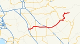
California State Route 140
Encyclopedia
State highway
State highway, state road or state route can refer to one of three related concepts, two of them related to a state or provincial government in a country that is divided into states or provinces :#A...
in the U.S. state
U.S. state
A U.S. state is any one of the 50 federated states of the United States of America that share sovereignty with the federal government. Because of this shared sovereignty, an American is a citizen both of the federal entity and of his or her state of domicile. Four states use the official title of...
of California
California
California is a state located on the West Coast of the United States. It is by far the most populous U.S. state, and the third-largest by land area...
, 102 miles (164 km) in length. It begins in the San Joaquin Valley
San Joaquin Valley
The San Joaquin Valley is the area of the Central Valley of California that lies south of the Sacramento – San Joaquin River Delta in Stockton...
at Interstate 5 near Gustine
Gustine, California
Gustine is a city in Merced County, California, United States. Gustine is located west of Merced, at an elevation of 98 feet . As of the United States 2010 Census, the city population was 5,520, up from 4,698 at the 2000 census.-Geography:...
, and runs east into the Sierra Nevada, terminating in Yosemite National Park
Yosemite National Park
Yosemite National Park is a United States National Park spanning eastern portions of Tuolumne, Mariposa and Madera counties in east central California, United States. The park covers an area of and reaches across the western slopes of the Sierra Nevada mountain chain...
.
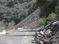
In June 2006, the road between El Portal
El Portal, California
El Portal is a census-designated place in Mariposa County, California. It is located west-southwest of Yosemite Village, at an elevation of 1939 feet . The population was 474 at the 2010 census....
and Mariposa
Mariposa, California
Mariposa is a census-designated place in and the county seat of Mariposa County, California, United States. The population was 2,173 at the 2010 census, up from 1,373 at the 2000 census. Its name is Spanish for "butterfly", after the flocks of Monarchs seen overwintering there by early...
was closed due to a rock slide. The Ferguson Slide buried about 600 feet (182.9 m) of SR140 between Cedar Lodge and Briceburg Visitor Center between SR-49
California State Route 49
State Route 49 is a north–south state highway in the U.S. state of California that passes through many historic mining communities of the 1849 California gold rush. Highway 49 is numbered after the "49ers", the waves of immigrants who swept into the area looking for gold, and a portion of it...
and SR-41
California State Route 41
State Route 41 is a state highway in the U.S. state of California, connecting the Cabrillo Highway in Morro Bay with Fresno and Yosemite National Park via the San Joaquin Valley. Except between US 101 in Atascadero and SR 46 near Shandon, SR 41 is part of the California Freeway and Expressway...
.
Though a detour opened in August, 2006, those anticipating travel between Mariposa and El Portal (Yosemite National Park) on SR140 are still advised to contact the National Park Service
National Park Service
The National Park Service is the U.S. federal agency that manages all national parks, many national monuments, and other conservation and historical properties with various title designations...
, California Highway Patrol
California Highway Patrol
The California Highway Patrol is a law enforcement agency of the U.S. state of California. The CHP has patrol jurisdiction over all California highways and also acts as the state police....
, Caltrans, or the Mariposa County Sheriff to find out if the road is open.
Route description
SR 140 is part of the California Freeway and Expressway SystemCalifornia Freeway and Expressway System
The California Freeway and Expressway System is a system of existing or planned freeways and expressways in the U.S. state of California. It is defined by the Streets and Highways Code.-List of roads in the system:*State Route 1 *State Route 2...
and is eligible for the State Scenic Highway System
State Scenic Highway System (California)
The State Scenic Highway System is a list of highways, mainly state highways, that have been designated by the California Department of Transportation as scenic highways. The California State Legislature, primarily through Section 263 of the Streets and Highways Code, makes highways eligible for...
. However, only the part of the road from Mariposa
Mariposa, California
Mariposa is a census-designated place in and the county seat of Mariposa County, California, United States. The population was 2,173 at the 2010 census, up from 1,373 at the 2000 census. Its name is Spanish for "butterfly", after the flocks of Monarchs seen overwintering there by early...
to El Portal
El Portal, California
El Portal is a census-designated place in Mariposa County, California. It is located west-southwest of Yosemite Village, at an elevation of 1939 feet . The population was 474 at the 2010 census....
is designated as a scenic highway.
Going east from I-5, it passes Gustine. It jogs to cross the San Joaquin River
San Joaquin River
The San Joaquin River is the largest river of Central California in the United States. At over long, the river starts in the high Sierra Nevada, and flows through a rich agricultural region known as the San Joaquin Valley before reaching Suisun Bay, San Francisco Bay, and the Pacific Ocean...
. It roughly marks the southern edge of the farmable land around Livingston
Livingston, California
Livingston is a city in Merced County, California. Livingston is located west-northwest of Atwater, at an elevation of 131 feet . According to the 2010 census, the city population was 13,058, up from 10,473 at the 2000 census. Livingston's total area is , including undeveloped farmland annexed in...
. It crosses State Route 99
California State Route 99
California State Route 99 , commonly known as Highway 99 or, simply, as 99 , is a north–south state highway in the U.S. state of California, stretching almost the entire length of the Central Valley...
at Merced
Merced, California
Merced is a city in, and the county seat of, Merced County, California in the San Joaquin Valley of Northern California. As of the 2010 census, the city had a population of 78,958. Incorporated in 1889, Merced is a charter city that operates under a council-manager government...
. Visitors who travel from the Bay Area
San Francisco Bay Area
The San Francisco Bay Area, commonly known as the Bay Area, is a populated region that surrounds the San Francisco and San Pablo estuaries in Northern California. The region encompasses metropolitan areas of San Francisco, Oakland, and San Jose, along with smaller urban and rural areas...
or northern California to Yosemite Valley
Yosemite Valley
Yosemite Valley is a glacial valley in Yosemite National Park in the western Sierra Nevada mountains of California, carved out by the Merced River. The valley is about long and up to a mile deep, surrounded by high granite summits such as Half Dome and El Capitan, and densely forested with pines...
or the southern portion of Yosemite will transfer from Highway 99 to Highway 140 at this point. (Those who visit the northern portion of Yosemite would have taken either State Route 120
California State Route 120
State Route 120 , in northern California, runs between the Central Valley near Manteca, through Yosemite National Park, and ends at U.S. Route 6 in Mono County.-Route description:...
east at Manteca
Manteca, California
Manteca is a city in , USA. As of the 2010 census, the city's population was 67,096.- History :Manteca is a city in the Central Valley of California, 76 miles east of San Francisco. It was founded in 1861 by Joshua Cowell. Cowell claimed around and built houses on what is now the corner of Main...
, or State Route 132
California State Route 132
State Route 132 is a route in the Central Valley that leads to the Sierra Nevada foothills and the California Gold Country. It also connects the city of Modesto with the San Francisco Bay Area via I-580, although this route is discouraged due to it being a two-lane road between Modesto and...
east at Modesto
Modesto, California
Modesto is a city in, and is the county seat of, Stanislaus County, California. With a population of approximately 201,165 at the 2010 census, Modesto ranks as the 18th largest city in the state of California....
.)
It continues through Planada
Planada, California
Planada is a census-designated place in Merced County, California, United States. Planada is located east of Merced, at an elevation of 226 feet...
, after which the farmland gives way to grazing land. It is quite dry in the summer due to California's Mediterranean climate
Mediterranean climate
A Mediterranean climate is the climate typical of most of the lands in the Mediterranean Basin, and is a particular variety of subtropical climate...
, and the dry grass gives the landscape a golden color. Western meadowlark
Western Meadowlark
Not to be confused with Eastern MeadowlarkThe Western Meadowlark is a medium-sized icterid bird, about 8.5 in long. It nests on the ground in open country in western and central North America. It feeds mostly on insects, but also seeds and berries...
s, American kestrel
American Kestrel
The American Kestrel , sometimes colloquially known as the Sparrow Hawk, is a small falcon, and the only kestrel found in the Americas. It is the most common falcon in North America, and is found in a wide variety of habitats. At long, it is also the smallest falcon in North America...
s, red-tailed hawk
Red-tailed Hawk
The Red-tailed Hawk is a bird of prey, one of three species colloquially known in the United States as the "chickenhawk," though it rarely preys on standard sized chickens. It breeds throughout most of North America, from western Alaska and northern Canada to as far south as Panama and the West...
s and even the occasional coyote
Coyote
The coyote , also known as the American jackal or the prairie wolf, is a species of canine found throughout North and Central America, ranging from Panama in the south, north through Mexico, the United States and Canada...
can be seen near the road. A few blue oak
Blue Oak
Quercus douglasii, the Blue Oak, is an oak in the white oak section of the genus, Quercus sect. Quercus. It is endemic to California and is found in foothills surrounding the Central Valley of California and certain locations in the California Coast Ranges, USA...
s can be seen as the highway leaves the valley and begins to climb the foothills of the Sierra Nevada. They become more and more numerous as the elevation increases. The highway passes through Catheys Valley
Catheys Valley, California
Catheys Valley is a census-designated place in Mariposa County, California. It lies in Catheys Valley 22 miles northeast of Merced, and southwest of Mariposa, at an elevation of 1325 feet . As of the 2010 census, Catheys Valley had a population of 825...
, and the vegetation begins to diversify a little. California live oaks and Ponderosa Pine
Ponderosa Pine
Pinus ponderosa, commonly known as the Ponderosa Pine, Bull Pine, Blackjack Pine, or Western Yellow Pine, is a widespread and variable pine native to western North America. It was first described by David Douglas in 1826, from eastern Washington near present-day Spokane...
s intermingle with the blue oaks as it nears Mariposa
Mariposa, California
Mariposa is a census-designated place in and the county seat of Mariposa County, California, United States. The population was 2,173 at the 2010 census, up from 1,373 at the 2000 census. Its name is Spanish for "butterfly", after the flocks of Monarchs seen overwintering there by early...
.
A ponderosa pine forest surrounds the road as it passes through Midpines
Midpines, California
Midpines is a census-designated place in Mariposa County, California. It is located southwest of El Portal, at an elevation of 2585 feet . It lies among the Sierra Nevada foothills of the central part of the state, 6 to 10 miles north of Mariposa, the county seat...
. At Briceburg
Briceburg, California
Briceburg is an unincorporated community in Mariposa County, California. It is located on the Merced River north-northwest of Midpines, at an elevation of 1138 feet ....
, it plunges down into the Merced River
Merced River
The Merced River , in the central part of the U.S. state of California, is a -long tributary of the San Joaquin River flowing from the Sierra Nevada into the Central Valley. It is most well known for its swift and steep course through the southern part of Yosemite National Park, and the...
valley. It runs alongside the Merced River
Merced River
The Merced River , in the central part of the U.S. state of California, is a -long tributary of the San Joaquin River flowing from the Sierra Nevada into the Central Valley. It is most well known for its swift and steep course through the southern part of Yosemite National Park, and the...
, through El Portal, and into Yosemite Valley, where it ends.
Major intersections
- Note: Except where prefixed with a letter, postmiles were measured in 1964, based on the alignment as it existed at that time, and do not necessarily reflect current mileage. The numbers reset at county lines; the start and end postmiles in each county are given in the county column.
{| class=wikitable
!County
!Location
!Postmile
!Exit
Exit number
An exit number is a number assigned to a road junction, usually an exit from a freeway. It is usually marked on the same sign as the destinations of the exit, as well as a sign in the gore....
!Destinations
!Notes
|-
|rowspan=14|Merced
Merced County, California
Merced County , is a county located in the Central Valley of the U.S. state of California, north of Fresno and southeast of San Jose. As of the 2010 census, the population was 255,793, up from 210,554 at the 2000 census. The county seat is Merced...
MER 0.00-50.30
|
|0.00
|
|Sullivan Road
|Continuation beyond I-5
|-
|
|0.00
|
|
|Interchange
|-
|rowspan=2|Gustine
Gustine, California
Gustine is a city in Merced County, California, United States. Gustine is located west of Merced, at an elevation of 98 feet . As of the United States 2010 Census, the city population was 5,520, up from 4,698 at the 2000 census.-Geography:...
|bgcolor=#ddffdd|4.35
|bgcolor=#ddffdd|
|bgcolor=#ddffdd|
|bgcolor=#ddffdd|West end of SR 33 overlap
|-bgcolor=#ddffdd
|6.06
|
|
|East end of SR 33 overlap
|-
|
|16.22
|
|
|
|-
|
|23.43
|
|Lincoln Boulevard – Livingston
Livingston, California
Livingston is a city in Merced County, California. Livingston is located west-northwest of Atwater, at an elevation of 131 feet . According to the 2010 census, the city population was 13,058, up from 10,473 at the 2000 census. Livingston's total area is , including undeveloped farmland annexed in...
|
|-
|
|29.47
|
|Applegate Road – Atwater
Atwater, California
Atwater is a city on U.S. Route 99 in Merced County, California, United States. Atwater is west-northwest of Merced, at an elevation of 151 feet . The population as of the 2010 census was 28,168.-Geography:...
|
|-
|rowspan=6|Merced
Merced, California
Merced is a city in, and the county seat of, Merced County, California in the San Joaquin Valley of Northern California. As of the 2010 census, the city had a population of 78,958. Incorporated in 1889, Merced is a charter city that operates under a council-manager government...
|bgcolor=#ddffdd|35.81
15.77Indicates that the postmile represents the distance along SR 99
California State Route 99
California State Route 99 , commonly known as Highway 99 or, simply, as 99 , is a north–south state highway in the U.S. state of California, stretching almost the entire length of the Central Valley...
rather than SR 140.
|bgcolor=#ddffdd|
|bgcolor=#ddffdd|
|bgcolor=#ddffdd|Interchange; west end of SR 99 / SR 59 overlap
|-
|colspan=4 align=center|West end of freeway on SR 99
|-bgcolor=#ddffdd
|14.69
|187B
|
|East end of SR 59 overlap
|-bgcolor=#ffdddd
|14.41
|187A
|G Street
|Westbound exit and eastbound entrance
|-
|colspan=4 align=center|East end of freeway on SR 99
|-bgcolor=#ddffdd
|13.86
35.82
|
|
|Interchange; east end of SR 99 overlap
|-
|Planada
Planada, California
Planada is a census-designated place in Merced County, California, United States. Planada is located east of Merced, at an elevation of 226 feet...
|43.70
|
|Plainsburg Road – Le Grand
Le Grand, California
Le Grand is a census-designated place in Merced County, California, United States. Le Grand is located east-southeast of Merced, at an elevation of 253 feet...
, Madera
Madera, California
Madera is a city in and the county seat of Madera County, California, United States. It is a principal city of the Madera–Chowchilla Metropolitan Statistical Area, which encompasses all of Madera County, and Metropolitan Fresno. It is located in California's San Joaquin Valley. As of the 2010...
, Fresno
Fresno, California
Fresno is a city in central California, United States, the county seat of Fresno County. As of the 2010 census, the city's population was 510,365, making it the fifth largest city in California, the largest inland city in California, and the 34th largest in the nation...
|
|-
|rowspan=6|Mariposa
Mariposa County, California
Mariposa County is a county in the U.S. state of California, located in the western foothills of the Sierra Nevada mountains. It lies north of Fresno, east of Merced, and southeast of Stockton. As of the 2010 census, the population was 18,251 up from 17,130 at the 2000 census...
MPA 0.00-51.80
|Catheys Valley
Catheys Valley, California
Catheys Valley is a census-designated place in Mariposa County, California. It lies in Catheys Valley 22 miles northeast of Merced, and southwest of Mariposa, at an elevation of 1325 feet . As of the 2010 census, Catheys Valley had a population of 825...
|9.50
|
|Hornitos Road – Hornitos
Hornitos, California
Hornitos is a census-designated place in Mariposa County, California. It is located on Burns Creek south of Coulterville, at an elevation of 843 feet . The population was 75 at the 2010 census....
|
|-
|rowspan=2|Mariposa
Mariposa, California
Mariposa is a census-designated place in and the county seat of Mariposa County, California, United States. The population was 2,173 at the 2010 census, up from 1,373 at the 2000 census. Its name is Spanish for "butterfly", after the flocks of Monarchs seen overwintering there by early...
|bgcolor=#ddffdd|21.22
|bgcolor=#ddffdd|
|bgcolor=#ddffdd|
|bgcolor=#ddffdd|West end of SR 49 overlap
|-bgcolor=#ddffdd
|22.00
|
|
|East end of SR 49 overlap
|-
|
|51.80
|colspan=3 align=center|East end of state maintenance at Yosemite National Park
Yosemite National Park
Yosemite National Park is a United States National Park spanning eastern portions of Tuolumne, Mariposa and Madera counties in east central California, United States. The park covers an area of and reaches across the western slopes of the Sierra Nevada mountain chain...
west boundary
|-
|
|
|
|

.svg.png)
California State Route 120
State Route 120 , in northern California, runs between the Central Valley near Manteca, through Yosemite National Park, and ends at U.S. Route 6 in Mono County.-Route description:...
/ US 395
U.S. Route 395 in California
In the U.S. state of California, U.S. Route 395 is a route which traverses from Interstate 15 near the southern city limits of Hesperia, north to the Oregon state line in Modoc County near Goose Lake...
– Manteca
Manteca, California
Manteca is a city in , USA. As of the 2010 census, the city's population was 67,096.- History :Manteca is a city in the Central Valley of California, 76 miles east of San Francisco. It was founded in 1861 by Joshua Cowell. Cowell claimed around and built houses on what is now the corner of Main...
|
|-
|
|bgcolor=#ffdddd|
|bgcolor=#ffdddd|
|bgcolor=#ffdddd|
|bgcolor=#ffdddd|Eastbound access only