
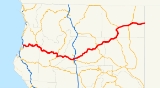
California State Route 299
Encyclopedia
State Route 299 is a state highway
in the U.S. state
of California
that runs across the northern part of the state
. It runs from Arcata
on the Pacific Ocean
to the border with Nevada
. Between Arcata and Redding
, Route 299 junctions with State Route 96
and is briefly co-signed with State Route 3. In Redding, it intersects with State Route 273
and State Route 44
and Interstate 5. East of Redding, it intersects with State Route 89
and a section is co-signed with State Route 139
before reaching Alturas
. It is then co-signed with U.S. Route 395 north-east of Alturas, then it runs east towards the border with Nevada. A ghost town, Vya, Nevada
, can be reached via this route, which after the border becomes a dirt road, which was formerly Nevada State Route 8A
.
Part of SR 299 is the Trinity Scenic Byway, a Forest Service Byway.
and is eligible for the State Scenic Highway System
.
SR 299 begins in Arcata
at a trumpet interchange with US 101 as a freeway. The route has another trumpet interchange with SR 200 after leaving the Arcata city limits and crossing the Mad River
. The freeway ends in the city of Blue Lake
as SR 299 continues east past the truck scales. SR 299 enters Six Rivers National Forest
and intersects SR 96 at Willow Creek
. Soon after this, SR 299 crosses into Trinity County
and Trinity National Forest
. Paralleling the Trinity River
, SR 299 passes through Salver (where there is a rest area), Burnt Ranch
, Del Loma, Big Bar, Helena
, Junction City
, and finally Weaverville
.
In Weaverville, SR 299 runs concurrently with SR 3 southbound to Douglas City
, where there is a rest area. SR 299 continues east away from the Trinity River into Shasta County
, passing by the Whiskeytown-Shasta National Recreation Area and through the towns of Tower House and Whiskeytown
as well as Whiskeytown Lake
. SR 299 continues along Eureka Way through the town of Shasta
into the city of Redding
. SR 299 runs concurrently along SR 273 north across the Sacramento River
before turning east onto its own freeway and intersecting I-5. SR 299 remains a freeway for a few miles before leaving the Redding city limits and passing through the town of Bella Vista
.
SR 299 continues through Ingot, Round Mountain
, Montgomery Creek
, Hillcrest (after the rest area), Burney
, and Johnson Park. The highway intersects with SR 89 before continuing through Fall River Mills
and McArthur
, where there is an intersection with CR A19. SR 299 then crosses into Lassen County
, where it passes through Nubieber
and Bieber
before intersecting CR A2. The highway crosses into Modoc County
and passes through Adin
, where it runs concurrently with SR 139 and passes through Modoc National Forest
. The concurrency lasts for several miles before SR 299 turns east and enters the city of Alturas
. SR 299 runs concurrently with US 395 before turning east again and passing through Cedarville
, near the Cedarville Airport
. SR 299 ends at the Nevada
state line.
{| class=wikitable
|-
!County
!Location
!Postmile
!Exit
!Destinations
!Notes
|-
|rowspan=10|Humboldt
HUM 0.00-43.04
|rowspan=2|Arcata
|0.00
|
|
|Westbound exit and eastbound entrance
|-
|0.72
|1
|Guintoli Lane, West End Road
|
|-
|
|R1.80
|2
|
|
|-
|
|bgcolor=#ffdddd|
|bgcolor=#ffdddd|3A
|bgcolor=#ffdddd|Glendale Drive
|bgcolor=#ffdddd|Eastbound exit only
|-
|
|R2.92
|3B
|Essex Lane
|
|-
|
|R4.04
|4
|Glendale Drive
|
|-
|
|R5.45
|5
|Glendale Drive – Blue Lake
|
|-
| colspan="5" style="text-align:center;"|East end of freeway
|-
|
|19.05
|
|Bair Road
|
|-
|Willow Creek
|38.83
|
|
|
|-
|rowspan=3|Trinity
TRI 0.00-72.25
|Weaverville
| style="background:#dfd;"|51.57
| style="background:#dfd;"|
| style="background:#dfd;"|, Trinity Lake
| style="background:#dfd;"|West end of SR 3 overlap
|-
|Douglas City
| style="background:#dfd;"|R58.11
| style="background:#dfd;"|
| style="background:#dfd;"|
| style="background:#dfd;"|East end of SR 3 overlap
|-
|
|67.43
|
|Trinity Dam Boulevard – Lewiston
, Lewiston Lake
, Trinity Lake
|
|-
|rowspan=17|Shasta
SHA 0.00-99.36
|
|8.65
|
|Trinity Mountain Road – French Gulch
|
|-
|
|
|
|Iron Mountain Road – Keswick
|
|-
|rowspan=7|Redding
|22.23
|
| Buenaventura Boulevard to SR 273
south – Anderson
|
|-
|23.81
|
|Court Street
|
|- style="background:#dfd;"
|24.09
16.83Indicates that the postmile represents the distance along SR 273
rather than SR 299.
|
|
|West end of SR 273 overlap
|- style="background:#dfd;"
|18.62
24.09
|
| – Portland
|East end of SR 273 overlap
|-
|24.82
|
| – Portland
, Sacramento
|Interchange
|-
| colspan="4" style="text-align:center;"|West end of freeway
|-
|25.54
|141
|Churn Creek Road, Hawley Road
|
|-
|
|27.24
|143
|Old Oregon Trail – Shasta College
|
|-
| colspan="5" style="text-align:center;"|East end of freeway
|-
|Bella Vista
|34.46
|
|Deschutes Road – Palo Cedro
, Anderson
|
|-
|Burney
|73.13
|
|Tamarack Road
|
|-
|
|80.09
|
|
|
|-
|Fall River Mills
|91.08
|
|
|
|-
|McArthur
|95.24
|
|
|
|-
|
|96.78
|
|Pittville Road – Pittville
|
|-
|Lassen
LAS 0.00-25.64
|Bieber
|15.10
|
|
|
|-
|rowspan=7|Modoc
MOD 0.00-66.63
|Adin
| style="background:#dfd;"|0.33
| style="background:#dfd;"|
| style="background:#dfd;"|
| style="background:#dfd;"|West end of SR 139 overlap
|-
|Canby
| style="background:#dfd;"|21.75
| style="background:#dfd;"|
| style="background:#dfd;"|, Klamath Falls
| style="background:#dfd;"|East end of SR 139 overlap
|-
|Alturas
| style="background:#dfd;"|40.63
22.76Indicates that the postmile represents the distance along US 395
rather than SR 299.
| style="background:#dfd;"|
| style="background:#dfd;"|, Reno
| style="background:#dfd;"|West end of US 395 overlap
|-
|
| style="background:#dfd;"|28.29
40.64
| style="background:#dfd;"|
| style="background:#dfd;"| – Lakeview
| style="background:#dfd;"|East end of US 395 overlap
|-
|Cedarville
|57.35
|
|Surprise Valley Road – Lake City
, Fort Bidwell
, Eagleville
|
|-
|
|66.63
| colspan="3" style="text-align:center;"|Nevada state line
|-
|
|66.63
|
|
|Continuation beyond the Nevada
state line
State highway
State highway, state road or state route can refer to one of three related concepts, two of them related to a state or provincial government in a country that is divided into states or provinces :#A...
in the U.S. state
U.S. state
A U.S. state is any one of the 50 federated states of the United States of America that share sovereignty with the federal government. Because of this shared sovereignty, an American is a citizen both of the federal entity and of his or her state of domicile. Four states use the official title of...
of California
California
California is a state located on the West Coast of the United States. It is by far the most populous U.S. state, and the third-largest by land area...
that runs across the northern part of the state
Northern California
Northern California is the northern portion of the U.S. state of California. The San Francisco Bay Area , and Sacramento as well as its metropolitan area are the main population centers...
. It runs from Arcata
Arcata, California
-Demographics:-2010 Census data:The 2010 United States Census reported that Arcata had a population of 17,231. The population density was 1,567.4 people per square mile...
on the Pacific Ocean
Pacific Ocean
The Pacific Ocean is the largest of the Earth's oceanic divisions. It extends from the Arctic in the north to the Southern Ocean in the south, bounded by Asia and Australia in the west, and the Americas in the east.At 165.2 million square kilometres in area, this largest division of the World...
to the border with Nevada
Nevada
Nevada is a state in the western, mountain west, and southwestern regions of the United States. With an area of and a population of about 2.7 million, it is the 7th-largest and 35th-most populous state. Over two-thirds of Nevada's people live in the Las Vegas metropolitan area, which contains its...
. Between Arcata and Redding
Redding, California
Redding is a city in far-Northern California. It is the county seat of Shasta County, California, USA. With a population of 89,861, according to the 2010 Census...
, Route 299 junctions with State Route 96
California State Route 96
State Route 96 follows the Trinity and Klamath Rivers in Northern California. For most of the route it goes through the Karuk Tribal Reservation, the Yurok Tribal Reservation, and the Hoopa Tribal Reservation...
and is briefly co-signed with State Route 3. In Redding, it intersects with State Route 273
California State Route 273
State Route 273 is a state highway in Shasta County, California, USA. The route takes a more direct approach to the cities of Anderson and Redding, passing through their downtown districts. Interstate 5 is a bypass of this route, as it connects both ends. This route was part of former U.S. Route...
and State Route 44
California State Route 44
State Route 44 is a state highway in the U.S. State of California that travels in an east–west direction from Redding to Lassen Volcanic National Park before ending at Route 36 west of Susanville...
and Interstate 5. East of Redding, it intersects with State Route 89
California State Route 89
State Route 89 is a California State Highway that travels in the north–south direction, and is the major thoroughfare for many mountain communities. It starts from U.S. Route 395 near Topaz Lake, winding its way up to the Monitor Pass, down to the Carson River, and up again over the Luther...
and a section is co-signed with State Route 139
California State Route 139
State Route 139 is a state highway in the U.S. state of California. Running from Susanville north to Oregon Route 39, it forms part of the shortest route between Reno, Nevada and Klamath Falls, Oregon. The entire route is part of the California Freeway and Expressway System, but is a two-lane road...
before reaching Alturas
Alturas, California
Alturas is the county seat of Modoc County, California, United States. Alturas is located on the Pit River, east of the center of Modoc County, at an elevation of 4370 feet...
. It is then co-signed with U.S. Route 395 north-east of Alturas, then it runs east towards the border with Nevada. A ghost town, Vya, Nevada
Vya, Nevada
Vya, Nevada is a small ghost town located in Washoe County, in northwestern Nevada. It is to the east of the California state line, about 10 miles plus. Not much remains of the small town, which essentially died in the 1920s. Just two wooden buildings can still be seen—the Vya Post Office and Library...
, can be reached via this route, which after the border becomes a dirt road, which was formerly Nevada State Route 8A
Nevada State Route 8A
Former State Route 8A was a two-part state highway in the U.S. state of Nevada, running from California State Route 299 in a general easterly and southeasterly direction via Vya and Denio to US 95 north of Winnemucca, and south from US 40 at Battle Mountain via Austin to US 6 near Tonopah...
.
Part of SR 299 is the Trinity Scenic Byway, a Forest Service Byway.
Route description
SR 299 is part of the California Freeway and Expressway SystemCalifornia Freeway and Expressway System
The California Freeway and Expressway System is a system of existing or planned freeways and expressways in the U.S. state of California. It is defined by the Streets and Highways Code.-List of roads in the system:*State Route 1 *State Route 2...
and is eligible for the State Scenic Highway System
State Scenic Highway System (California)
The State Scenic Highway System is a list of highways, mainly state highways, that have been designated by the California Department of Transportation as scenic highways. The California State Legislature, primarily through Section 263 of the Streets and Highways Code, makes highways eligible for...
.
SR 299 begins in Arcata
Arcata, California
-Demographics:-2010 Census data:The 2010 United States Census reported that Arcata had a population of 17,231. The population density was 1,567.4 people per square mile...
at a trumpet interchange with US 101 as a freeway. The route has another trumpet interchange with SR 200 after leaving the Arcata city limits and crossing the Mad River
Mad River (California)
The Mad River is a river in upper Northern California. It flows for in a roughly northwest direction through Trinity County and then Humboldt County, draining a watershed into the Pacific Ocean north of the college town of Arcata near Arcata-Eureka Airport in McKinleyville...
. The freeway ends in the city of Blue Lake
Blue Lake, California
Blue Lake is a city in Humboldt County, California, United States. Blue Lake is located on the Mad River northeast of Eureka, at an elevation of 131 feet...
as SR 299 continues east past the truck scales. SR 299 enters Six Rivers National Forest
Six Rivers National Forest
Six Rivers National Forest is a U.S. National Forest located in the northwestern corner of California. It was established on July 1, 1947 by U.S. President Harry S. Truman from portions of Klamath, Siskiyou and Trinity National Forests. Its over one million acres of land contain a variety of...
and intersects SR 96 at Willow Creek
Willow Creek, California
Willow Creek is a census-designated place in Humboldt County, California, United States. The population was 1,710 at the 2010 census, down from 1,743 at the 2000 census....
. Soon after this, SR 299 crosses into Trinity County
Trinity County, California
Trinity County is a large, rugged and mountainous, heavily forested county located in the northwestern portion of the U.S. state of California, along the Trinity River and within the Salmon/Klamath Mountains. It covers an area of over two million acres , and as of the 2010 census its population...
and Trinity National Forest
Trinity National Forest
Trinity National Forest was established as the Trinity Forest Reserve by the U.S. Forest Service in California on April 26, 1905 with . It became a National Forest on March 4, 1907. On July 1, 1908 it gave up some acreage to California National Forest. In 1954 it was combined administratively with...
. Paralleling the Trinity River
Trinity River (California)
The Trinity River is the longest tributary of the Klamath River, approximately long, in northwestern California in the United States. It drains an area of the Coast Ranges, including the southern Klamath Mountains, northwest of the Sacramento Valley...
, SR 299 passes through Salver (where there is a rest area), Burnt Ranch
Burnt Ranch, California
Burnt Ranch is a census-designated place in Trinity County, California. It has a school and a post office. The ZIP Code is 95527. The community is inside area code 530. Burnt Ranch sits at an elevation of...
, Del Loma, Big Bar, Helena
Helena, California
Helena is an unincorporated community in Trinity County, California, United States. Helena is located on the North Fork of the Trinity River west-northwest of Weaverville. The community was settled in 1851 as a mining camp. It was known as Bagdad, North Fork, and The Cove before its post office...
, Junction City
Junction City, California
Junction City is a census-designated place in Trinity County, California. Junction City sits at an elevation of . Junction City is located west of Weaverville. The ZIP Code is 96048. The community is inside area code 530...
, and finally Weaverville
Weaverville, California
Weaverville is a census-designated place and the county seat of Trinity County, California. The population was 3,600 at the 2010 census, up from 3,554 at the 2000 census.-History:Founded in 1850, Weaverville is a historic California Gold Rush town...
.
In Weaverville, SR 299 runs concurrently with SR 3 southbound to Douglas City
Douglas City, California
Douglas City is a census-designated place in Trinity County, California. Douglas City sits at an elevation of . The ZIP Code is 96024. The community is inside area code 530...
, where there is a rest area. SR 299 continues east away from the Trinity River into Shasta County
Shasta County, California
Shasta County is a county located in the northern portion of the U.S. state of California. The county occupies the northern reaches of the Sacramento Valley, with portions extending into the southern reaches of the Cascade Range. As of the 2010 census, the population was 177,223, up from 163,256...
, passing by the Whiskeytown-Shasta National Recreation Area and through the towns of Tower House and Whiskeytown
Whiskeytown, California
Whiskeytown is an unincorporated community in Shasta County, California, United States. The ZIP Code is 96095. The community is inside area code 530. Although once a bustling mining town, there are very few people living in Whiskeytown as of today. The entire town of Whiskeytown was flooded to make...
as well as Whiskeytown Lake
Whiskeytown Lake
Whiskeytown Lake is a lake in Shasta County in northwestern California, about west of Redding. The lake is in the Whiskeytown Unit of the Whiskeytown-Shasta-Trinity National Recreation Area. It has a capacity of and is formed by Whiskeytown Dam on Clear Creek...
. SR 299 continues along Eureka Way through the town of Shasta
Shasta, California
Shasta is a census-designated place in Shasta County, California. Shasta sits at an elevation of . The 2010 United States census reported Shasta's population was 1,771....
into the city of Redding
Redding, California
Redding is a city in far-Northern California. It is the county seat of Shasta County, California, USA. With a population of 89,861, according to the 2010 Census...
. SR 299 runs concurrently along SR 273 north across the Sacramento River
Sacramento River
The Sacramento River is an important watercourse of Northern and Central California in the United States. The largest river in California, it rises on the eastern slopes of the Klamath Mountains, and after a journey south of over , empties into Suisun Bay, an arm of the San Francisco Bay, and...
before turning east onto its own freeway and intersecting I-5. SR 299 remains a freeway for a few miles before leaving the Redding city limits and passing through the town of Bella Vista
Bella Vista, California
Bella Vista is a census-designated place in Shasta County, California. Bella Vista is a small, rural community about north-east of Redding, and about north of Palo Cedro. Bella Vista sits at an elevation of...
.
SR 299 continues through Ingot, Round Mountain
Round Mountain, California
Round Mountain is a census-designated place in Shasta County, California, United States. The population was 155 at the 2010 census, up from 122 at the 2000 census.-Geography:Round Mountain is located at ....
, Montgomery Creek
Montgomery Creek, California
Montgomery Creek is a census-designated place in Shasta County, California, United States. The population was 163 at the 2010 census, up from 96 at the 2000 census...
, Hillcrest (after the rest area), Burney
Burney, California
Burney is an unincorporated town and census-designated place in Shasta County, California, United States. The population was 3,154 at the 2010 census, down from 3,217 at the 2000 census...
, and Johnson Park. The highway intersects with SR 89 before continuing through Fall River Mills
Fall River Mills, California
Fall River Mills is an unincorporated town and census-designated place in Shasta County, California, United States. The population was 573 as of the 2010 census.-Production & Industry:The community is known for its agriculture...
and McArthur
McArthur, California
McArthur is a census-designated place in Shasta County, California, United States. The population was 338 at the 2010 census, down from 365 at the 2000 census...
, where there is an intersection with CR A19. SR 299 then crosses into Lassen County
Lassen County, California
Lassen County is a county located in the northeastern portion of the U.S. state of California. As of the 2010 census, the population was 34,895, up from 33,828 at the 2000 census...
, where it passes through Nubieber
Nubieber, California
Nubieber is a census-designated place in Lassen County, California. It was located at the common terminus of the Western Pacific Railroad and the Great Northern Railway Bieber Line southwest of Bieber, at an elevation of 4121 feet...
and Bieber
Bieber, California
Bieber is a census-designated place in Lassen County, California. It is located on the Pit River north-northwest of Susanville, at an elevation of 4124 feet . Its population was 312 at the 2010 census. The ZIP Code is 96009. The community is inside area code 530.-History:The settlement sprang up...
before intersecting CR A2. The highway crosses into Modoc County
Modoc County, California
Modoc County is a county located in the far northeast corner of the U.S. state of California, bounded by the state of Oregon to the north and the state of Nevada to the east. As of the 2010 census, its population was 9,686, up from 9,449 at the 2000 census. The current county seat is Alturas, the...
and passes through Adin
Adin, California
Adin is a census-designated place in Modoc County, California. It is located southwest of Alturas, at an elevation of 4203 feet...
, where it runs concurrently with SR 139 and passes through Modoc National Forest
Modoc National Forest
Modoc National Forest is a national forest in northeastern California, covering parts of Modoc , Lassen , and Siskiyou counties. Most of the forest was covered by an immense lava flow millions of years ago. The eastern part of the forest east of Alturas contains a spur of the Cascade Range to...
. The concurrency lasts for several miles before SR 299 turns east and enters the city of Alturas
Alturas, California
Alturas is the county seat of Modoc County, California, United States. Alturas is located on the Pit River, east of the center of Modoc County, at an elevation of 4370 feet...
. SR 299 runs concurrently with US 395 before turning east again and passing through Cedarville
Cedarville, California
Cedarville is a census-designated place in Modoc County, California. It is located east of Alturas, at an elevation of 4652 feet ....
, near the Cedarville Airport
Cedarville Airport
Cedarville Airport is a public airport located two miles north of Cedarville, serving Modoc County, California, USA. The airport is mostly used for general aviation.- Facilities :Cedarville Airport covers and has one runway:...
. SR 299 ends at the Nevada
Nevada
Nevada is a state in the western, mountain west, and southwestern regions of the United States. With an area of and a population of about 2.7 million, it is the 7th-largest and 35th-most populous state. Over two-thirds of Nevada's people live in the Las Vegas metropolitan area, which contains its...
state line.
History
State Route 299, from the intersection with US 101 all the way to US 395 in Alturas, was U.S. Route 299 from 1934 to 1964, but the actual road has been realigned many times, mainly to make easier grades and curves through the mountains. In many places, especially in Trinity County, the old concrete can be seen beside the new road, and there is even an arch bridge from 1923 visible from the current 299, that seemingly connects nothing to nothing nowadays. In 1934, it was the original California State Route 44.Major intersections
- Note: Except where prefixed with a letter, postmiles were measured in 1964, based on the alignment as it existed at that time, and do not necessarily reflect current mileage. The numbers reset at county lines; the start and end postmiles in each county are given in the county column.
{| class=wikitable
|-
!County
!Location
!Postmile
!Exit
Exit number
An exit number is a number assigned to a road junction, usually an exit from a freeway. It is usually marked on the same sign as the destinations of the exit, as well as a sign in the gore....
!Destinations
!Notes
|-
|rowspan=10|Humboldt
Humboldt County, California
Humboldt County is a county in the U.S. state of California, located on the far North Coast 200 miles north of San Francisco. According to 2010 Census Data, the county’s population was 134,623...
HUM 0.00-43.04
|rowspan=2|Arcata
Arcata, California
-Demographics:-2010 Census data:The 2010 United States Census reported that Arcata had a population of 17,231. The population density was 1,567.4 people per square mile...
|0.00
|
|
|Westbound exit and eastbound entrance
|-
|0.72
|1
|Guintoli Lane, West End Road
|
|-
|
|R1.80
|2
|
|
|-
|
|bgcolor=#ffdddd|
|bgcolor=#ffdddd|3A
|bgcolor=#ffdddd|Glendale Drive
|bgcolor=#ffdddd|Eastbound exit only
|-
|
|R2.92
|3B
|Essex Lane
|
|-
|
|R4.04
|4
|Glendale Drive
|
|-
|
|R5.45
|5
|Glendale Drive – Blue Lake
Blue Lake, California
Blue Lake is a city in Humboldt County, California, United States. Blue Lake is located on the Mad River northeast of Eureka, at an elevation of 131 feet...
|
|-
| colspan="5" style="text-align:center;"|East end of freeway
|-
|
|19.05
|
|Bair Road
|
|-
|Willow Creek
Willow Creek, California
Willow Creek is a census-designated place in Humboldt County, California, United States. The population was 1,710 at the 2010 census, down from 1,743 at the 2000 census....
|38.83
|
|
|
|-
|rowspan=3|Trinity
Trinity County, California
Trinity County is a large, rugged and mountainous, heavily forested county located in the northwestern portion of the U.S. state of California, along the Trinity River and within the Salmon/Klamath Mountains. It covers an area of over two million acres , and as of the 2010 census its population...
TRI 0.00-72.25
|Weaverville
Weaverville, California
Weaverville is a census-designated place and the county seat of Trinity County, California. The population was 3,600 at the 2010 census, up from 3,554 at the 2000 census.-History:Founded in 1850, Weaverville is a historic California Gold Rush town...
| style="background:#dfd;"|51.57
| style="background:#dfd;"|
| style="background:#dfd;"|, Trinity Lake
Trinity Lake
Trinity Lake, previously called Clair Engle Lake, is a lake on the Trinity River formed by the Trinity Dam and located in Trinity County, California, The dam was built by the U.S. Bureau of Reclamation. The lake has a capacity of , making it one of the largest reservoirs in California. The lake's...
| style="background:#dfd;"|West end of SR 3 overlap
|-
|Douglas City
Douglas City, California
Douglas City is a census-designated place in Trinity County, California. Douglas City sits at an elevation of . The ZIP Code is 96024. The community is inside area code 530...
| style="background:#dfd;"|R58.11
| style="background:#dfd;"|
| style="background:#dfd;"|
| style="background:#dfd;"|East end of SR 3 overlap
|-
|
|67.43
|
|Trinity Dam Boulevard – Lewiston
Lewiston, California
Lewiston is a census-designated place in Trinity County, California, United States. The population was 1,193 at the 2010 census, down from 1,305 at the 2000 census.-Geography:Lewiston is located at ....
, Lewiston Lake
Lewiston Lake
Lewiston Lake is a reservoir created by Lewiston Dam on the Trinity River, near the towns of Weaverville and Lewiston in Trinity County, California. It is used for transbasin diversion to the Sacramento River and flood control, as well as for hydroelectric generation, and is a popular destination...
, Trinity Lake
Trinity Lake
Trinity Lake, previously called Clair Engle Lake, is a lake on the Trinity River formed by the Trinity Dam and located in Trinity County, California, The dam was built by the U.S. Bureau of Reclamation. The lake has a capacity of , making it one of the largest reservoirs in California. The lake's...
|
|-
|rowspan=17|Shasta
Shasta County, California
Shasta County is a county located in the northern portion of the U.S. state of California. The county occupies the northern reaches of the Sacramento Valley, with portions extending into the southern reaches of the Cascade Range. As of the 2010 census, the population was 177,223, up from 163,256...
SHA 0.00-99.36
|
|8.65
|
|Trinity Mountain Road – French Gulch
French Gulch, California
French Gulch is a census-designated place in Shasta County, California, United States. The population was 346 at the 2010 census, up from 254 at the 2000 census.-Geography:French Gulch is located at ....
|
|-
|
|
|
|Iron Mountain Road – Keswick
Keswick, California
Keswick is a census-designated place in Shasta County, California. Keswick sits at an elevation of . The 2010 United States census reported Keswick's population was 451.-Geography:...
|
|-
|rowspan=7|Redding
Redding, California
Redding is a city in far-Northern California. It is the county seat of Shasta County, California, USA. With a population of 89,861, according to the 2010 Census...
|22.23
|
|
California State Route 273
State Route 273 is a state highway in Shasta County, California, USA. The route takes a more direct approach to the cities of Anderson and Redding, passing through their downtown districts. Interstate 5 is a bypass of this route, as it connects both ends. This route was part of former U.S. Route...
south – Anderson
Anderson, California
Anderson is a city in Shasta County, California, USA, approximately 10 miles south of Redding. The population was 9,932 at the 2010 census, up from 9,022 at the 2000 census....
|
|-
|23.81
|
|Court Street
|
|- style="background:#dfd;"
|24.09
16.83Indicates that the postmile represents the distance along SR 273
California State Route 273
State Route 273 is a state highway in Shasta County, California, USA. The route takes a more direct approach to the cities of Anderson and Redding, passing through their downtown districts. Interstate 5 is a bypass of this route, as it connects both ends. This route was part of former U.S. Route...
rather than SR 299.
|
|
|West end of SR 273 overlap
|- style="background:#dfd;"
|18.62
24.09
|
| – Portland
Portland, Oregon
Portland is a city located in the Pacific Northwest, near the confluence of the Willamette and Columbia rivers in the U.S. state of Oregon. As of the 2010 Census, it had a population of 583,776, making it the 29th most populous city in the United States...
|East end of SR 273 overlap
|-
|24.82
|
| – Portland
Portland, Oregon
Portland is a city located in the Pacific Northwest, near the confluence of the Willamette and Columbia rivers in the U.S. state of Oregon. As of the 2010 Census, it had a population of 583,776, making it the 29th most populous city in the United States...
, Sacramento
Sacramento, California
Sacramento is the capital city of the U.S. state of California and the county seat of Sacramento County. It is located at the confluence of the Sacramento River and the American River in the northern portion of California's expansive Central Valley. With a population of 466,488 at the 2010 census,...
|Interchange
|-
| colspan="4" style="text-align:center;"|West end of freeway
|-
|25.54
|141
|Churn Creek Road, Hawley Road
|
|-
|
|27.24
|143
|Old Oregon Trail – Shasta College
Shasta College
Shasta College is an American two-year to four- year community college located in Redding, California founded in 1950. It later moved to a much bigger campus, while the original campus became the new location of Shasta High School....
|
|-
| colspan="5" style="text-align:center;"|East end of freeway
|-
|Bella Vista
Bella Vista, California
Bella Vista is a census-designated place in Shasta County, California. Bella Vista is a small, rural community about north-east of Redding, and about north of Palo Cedro. Bella Vista sits at an elevation of...
|34.46
|
|Deschutes Road – Palo Cedro
Palo Cedro, California
Palo Cedro is a census-designated place in Shasta County, California, United States. The population was 1,269 at the 2010 census, up from 1,247 at the 2000 census. It is east of Redding, California. The communities of Bella Vista , Millville , Shingletown , Oak Run , Whitmore , and Round...
, Anderson
Anderson, California
Anderson is a city in Shasta County, California, USA, approximately 10 miles south of Redding. The population was 9,932 at the 2010 census, up from 9,022 at the 2000 census....
|
|-
|Burney
Burney, California
Burney is an unincorporated town and census-designated place in Shasta County, California, United States. The population was 3,154 at the 2010 census, down from 3,217 at the 2000 census...
|73.13
|
|Tamarack Road
|
|-
|
|80.09
|
|
|
|-
|Fall River Mills
Fall River Mills, California
Fall River Mills is an unincorporated town and census-designated place in Shasta County, California, United States. The population was 573 as of the 2010 census.-Production & Industry:The community is known for its agriculture...
|91.08
|
|
|
|-
|McArthur
McArthur, California
McArthur is a census-designated place in Shasta County, California, United States. The population was 338 at the 2010 census, down from 365 at the 2000 census...
|95.24
|
|
|
|-
|
|96.78
|
|Pittville Road – Pittville
|
|-
|Lassen
Lassen County, California
Lassen County is a county located in the northeastern portion of the U.S. state of California. As of the 2010 census, the population was 34,895, up from 33,828 at the 2000 census...
LAS 0.00-25.64
|Bieber
Bieber, California
Bieber is a census-designated place in Lassen County, California. It is located on the Pit River north-northwest of Susanville, at an elevation of 4124 feet . Its population was 312 at the 2010 census. The ZIP Code is 96009. The community is inside area code 530.-History:The settlement sprang up...
|15.10
|
|
|
|-
|rowspan=7|Modoc
Modoc County, California
Modoc County is a county located in the far northeast corner of the U.S. state of California, bounded by the state of Oregon to the north and the state of Nevada to the east. As of the 2010 census, its population was 9,686, up from 9,449 at the 2000 census. The current county seat is Alturas, the...
MOD 0.00-66.63
|Adin
Adin, California
Adin is a census-designated place in Modoc County, California. It is located southwest of Alturas, at an elevation of 4203 feet...
| style="background:#dfd;"|0.33
| style="background:#dfd;"|
| style="background:#dfd;"|
| style="background:#dfd;"|West end of SR 139 overlap
|-
|Canby
Canby, California
Canby is a census-designated place in Modoc County, California. It is located west of Alturas, at an elevation of 4314 feet . It had a population of 315 at the 2010 census. The ZIP Code is 96015...
| style="background:#dfd;"|21.75
| style="background:#dfd;"|
| style="background:#dfd;"|, Klamath Falls
Klamath Falls, Oregon
Klamath Falls is a city in Klamath County, Oregon, United States. Originally called Linkville when George Nurse founded the town in 1867, after the Link River on whose falls this city sat, although no falls currently exist; the name was changed to Klamath Falls in 1892...
| style="background:#dfd;"|East end of SR 139 overlap
|-
|Alturas
Alturas, California
Alturas is the county seat of Modoc County, California, United States. Alturas is located on the Pit River, east of the center of Modoc County, at an elevation of 4370 feet...
| style="background:#dfd;"|40.63
22.76Indicates that the postmile represents the distance along US 395
U.S. Route 395 in California
In the U.S. state of California, U.S. Route 395 is a route which traverses from Interstate 15 near the southern city limits of Hesperia, north to the Oregon state line in Modoc County near Goose Lake...
rather than SR 299.
| style="background:#dfd;"|
| style="background:#dfd;"|, Reno
Reno, Nevada
Reno is the county seat of Washoe County, Nevada, United States. The city has a population of about 220,500 and is the most populous Nevada city outside of the Las Vegas metropolitan area...
| style="background:#dfd;"|West end of US 395 overlap
|-
|
| style="background:#dfd;"|28.29
40.64
| style="background:#dfd;"|
| style="background:#dfd;"| – Lakeview
Lakeview, Oregon
Lakeview is a city in Lake County, Oregon, United States. The population was 2,294 at the 2010 census. It is the county seat of Lake County. Although it is an incorporated city, the municipal government refers to the community as "The Town of Lakeview", and bills itself as "Tallest Town in Oregon"...
| style="background:#dfd;"|East end of US 395 overlap
|-
|Cedarville
Cedarville, California
Cedarville is a census-designated place in Modoc County, California. It is located east of Alturas, at an elevation of 4652 feet ....
|57.35
|
|Surprise Valley Road – Lake City
Lake City, Modoc County, California
Lake City is a census-designated place in Modoc County, California. It is located north-northwest of Cedarville, at an elevation of 4626 feet . The population was 61 at the 2010 census....
, Fort Bidwell
Fort Bidwell, California
Fort Bidwell is a census-designated place in Modoc County, California. It is located northeast of Alturas, at an elevation of 4564 feet . The population was 173 at the 2010 census.-Geography:...
, Eagleville
Eagleville, Modoc County, California
Eagleville is a census-designated place in Modoc County, California. It is located east-southeast of Alturas, at an elevation of 4642 feet . The population was 59 at the 2010 census....
|
|-
|
|66.63
| colspan="3" style="text-align:center;"|Nevada state line
|-
|
|66.63
|
|
|Continuation beyond the Nevada
Nevada
Nevada is a state in the western, mountain west, and southwestern regions of the United States. With an area of and a population of about 2.7 million, it is the 7th-largest and 35th-most populous state. Over two-thirds of Nevada's people live in the Las Vegas metropolitan area, which contains its...
state line