
California State Route 29
Encyclopedia
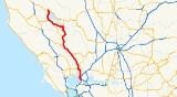
State Route 29 is a state highway
in the U.S. state
of California
that travels in a north–south direction from State Route 20 in Upper Lake
to Interstate 80
in Vallejo
.
 This route is part of the California Freeway and Expressway System
and is eligible for the State Scenic Highway System
. However, it is not a scenic highway as defined by Caltrans.
SR 29 starts as a two-lane highway until Lakeport
and becomes a freeway as it bypasses the city. South of the city, it reverts back to a two-lane highway, going around Clear Lake, the largest natural freshwater lake completely within California, passing through Kelseyville
, Lower Lake
, and Middletown
. It then climbs Mount Saint Helena
, an extinct volcano
, at the border between Lake County
and Napa County
. Through Napa Valley, the highway passes through Calistoga
, St. Helena
, Rutherford, Oakville, Yountville
and Napa
while passing many of the region's notable vineyards and wineries
. This portion of the highway is often heavily congested with rental cars and tour buses in spring and summer, when tourists flock to Napa Valley from San Francisco.
The route briefly becomes a freeway again as it passes through the city of Napa, then returns to a four-lane expressway
(on some segments, five) for the rest of its length. It terminates at I-80 near the Al Zampa Bridge
in Vallejo.
Historically, the route between Middletown and the Napa Valley was served by the Old Bull Trail Road, built by volunteers in the 1850s that had grades up to 35 percent. That was replaced by the St. Helena Toll Road in 1868, which had more manageable inclines of up to 12 percent. The State of California purchased the toll road in 1925.
The points of interest along Route 29 include the Lower Lake Stone Jail
, the Stone House
, The St. Helena Toll Road and Bull Trail, The Robert Louis Stevenson State Park
, The Bale Grist Mill State Historic Park
and the Bothe-Napa Valley State Park
.
California State Route 29 may be most famous for its path through the heart of Napa Valley, considered by many to be America's most prestigious wine region. Many famed wineries, including Robert Mondavi, Beringer and Sutter Home are located along Route 29.
{| class=wikitable
!County
!Location
!Postmile
!Exit
!Destinations
!Notes
|-
|rowspan=8|Solano
SOL 0.00-5.96
|rowspan=8|Vallejo
|0.00
|
| – California Maritime Academy
|Interchange
|-
|
|
| Magazine Street to I-80
|
|-
|1.01
|
| Lemon Street to I-680
/ I-780
|
|-
|
|
| Curtola Parkway to I-780
|
|-
|2.07
|
|Maine Street
|Former SR 141
|-
|2.82
|
|Tennessee Street
|
|-
|
|
|Redwood Street
|
|-
|4.73
|
|
|Interchange
|-
|rowspan=15|Napa
NAP 0.00-48.58
|
|0.69
|
|American Canyon Road
|
|-
|
|bgcolor=#ddffdd|4.71
|bgcolor=#ddffdd|
|bgcolor=#ddffdd|, Napa County Airport
|bgcolor=#ddffdd|South end of SR 12 overlap
|-
|
|R6.20
|
|
|
|-
|
|bgcolor=#ddffdd|R8.66
|bgcolor=#ddffdd|
|bgcolor=#ddffdd|
|bgcolor=#ddffdd|North end of SR 12 overlap; south end of SR 121 overlap
|-
|colspan=5 align=center|South end of freeway
|-
|rowspan=6|Napa
|bgcolor=#ddffdd|10.31
|bgcolor=#ddffdd|16
|bgcolor=#ddffdd|
|bgcolor=#ddffdd|North end of SR 121 overlap
|-
|11.55
|18A
|First Street – Downtown Napa
|
|-
|12.04
|18B
|Lincoln Avenue
|
|-
|13.06
|19
|Trancas Street, Redwood Road
|Former SR 221
|-
|colspan=4 align=center|North end of freeway
|-bgcolor=#ffdddd
|
|
|Sierra Avenue
|Interchange; northbound exit and entrance
|-
|Yountville
|19.03
|
|Yountville
, Veterans Home (California Drive)
|Interchange
|-
|Rutherford
|bgcolor=#ddffdd|24.60
|bgcolor=#ddffdd|
|bgcolor=#ddffdd|
|bgcolor=#ddffdd|South end of SR 128 overlap
|-
|Calistoga
|bgcolor=#ddffdd|36.89
|bgcolor=#ddffdd|
|bgcolor=#ddffdd|
|bgcolor=#ddffdd|North end of SR 128 overlap
|-
|
|39.50
|
|Tubbs Lane – Santa Rosa
, Geyserville
|
|-
|rowspan=12|Lake
LAK 0.00-52.54
|Middletown
|5.81
|
|
|
|-
|Lower Lake
|20.31
|
|
|
|-
|
|27.89
|
|
|
|-
|
|bgcolor=#ddffdd|31.05
|bgcolor=#ddffdd|
|bgcolor=#ddffdd|
|bgcolor=#ddffdd|South end of SR 175 overlap
|-
|
|bgcolor=#ddffdd|R40.14
|bgcolor=#ddffdd|
|bgcolor=#ddffdd|
|bgcolor=#ddffdd|North end of SR 175 overlap
|-
|colspan=5 align=center|South end of freeway
|-
|rowspan=2|Lakeport
|R41.42
|102
|Lakeport Boulevard, Todd Road – Lakeport
|
|-
|R42.68
|103
|11th Street, Scotts Valley Road – Lakeport
|
|-
|
|R45.15
|106
|Hill Road, Park Way
|
|-
|
|R47.85
|108
|Nice-Lucerne Cutoff (SR 29 Bus. south)
|
|-
|colspan=5 align=center|North end of freeway
|-
|
|52.54
|
| – North Shore Resorts, Williams
|
State highway
State highway, state road or state route can refer to one of three related concepts, two of them related to a state or provincial government in a country that is divided into states or provinces :#A...
in the U.S. state
U.S. state
A U.S. state is any one of the 50 federated states of the United States of America that share sovereignty with the federal government. Because of this shared sovereignty, an American is a citizen both of the federal entity and of his or her state of domicile. Four states use the official title of...
of California
California
California is a state located on the West Coast of the United States. It is by far the most populous U.S. state, and the third-largest by land area...
that travels in a north–south direction from State Route 20 in Upper Lake
Upper Lake, California
Upper Lake is a census-designated place in Lake County, California, United States. Upper Lake is located north of Lakeport, at an elevation of 1345 feet . The population was 1,052 at the 2010 census, up from 989 at the 2000 census...
to Interstate 80
Interstate 80 in California
In the U.S. state of California, Interstate 80 , a major east–west route of the Interstate Highway System, has its western terminus in San Francisco, California, United States. From there it heads east across the Bay Bridge to Oakland, where it turns north and crosses the Carquinez Bridge...
in Vallejo
Vallejo, California
Vallejo is the largest city in Solano County, California, United States. The population was 115,942 at the 2010 census. It is located in the San Francisco Bay Area on the northeastern shore of San Pablo Bay...
.
Route description
California Freeway and Expressway System
The California Freeway and Expressway System is a system of existing or planned freeways and expressways in the U.S. state of California. It is defined by the Streets and Highways Code.-List of roads in the system:*State Route 1 *State Route 2...
and is eligible for the State Scenic Highway System
State Scenic Highway System (California)
The State Scenic Highway System is a list of highways, mainly state highways, that have been designated by the California Department of Transportation as scenic highways. The California State Legislature, primarily through Section 263 of the Streets and Highways Code, makes highways eligible for...
. However, it is not a scenic highway as defined by Caltrans.
SR 29 starts as a two-lane highway until Lakeport
Lakeport, California
Lakeport is an incorporated city and county seat of Lake County, California. Lakeport is located on the west shore of Clear Lake, at an elevation of 1355 feet...
and becomes a freeway as it bypasses the city. South of the city, it reverts back to a two-lane highway, going around Clear Lake, the largest natural freshwater lake completely within California, passing through Kelseyville
Kelseyville, California
Kelseyville is a census-designated place in Lake County, California, United States. Kelseyville is located southeast of Lakeport, at an elevation of 1384 feet...
, Lower Lake
Lower Lake, California
Lower Lake is a census-designated place in Lake County, California, USA. Lower Lake is located east-southeast of Kelseyville, at an elevation of 1371 feet...
, and Middletown
Middletown, California
Middletown is a census-designated place in Lake County, California, United States. Middletown is located south of Lower Lake, at an elevation of 1099 feet . The population was 1,323 at the 2010 census, up from 1,020 at the 2000 census...
. It then climbs Mount Saint Helena
Mount Saint Helena
Mount Saint Helena is a peak in the Mayacamas Mountains with flanks in Napa, Sonoma, and Lake counties of California. Composed of uplifted 2.4-million-year-old volcanic rocks from the Clear Lake Volcanic Field, it is one of the few mountains in the San Francisco Bay Area to receive any snowfall...
, an extinct volcano
Volcano
2. Bedrock3. Conduit 4. Base5. Sill6. Dike7. Layers of ash emitted by the volcano8. Flank| 9. Layers of lava emitted by the volcano10. Throat11. Parasitic cone12. Lava flow13. Vent14. Crater15...
, at the border between Lake County
Lake County, California
Lake County is a county located in the north central portion of the U.S. state of California, north of the San Francisco Bay Area. It takes its name from Clear Lake, the dominant geographic feature in the county and the largest natural lake wholly within California...
and Napa County
Napa County, California
Napa County is a county located north of the San Francisco Bay Area in the U.S. state of California. It is coterminous with the Napa, California, Metropolitan Statistical Area. As of 2010 the population is 136,484. The county seat is Napa....
. Through Napa Valley, the highway passes through Calistoga
Calistoga, California
Calistoga is a city in Napa County, California, United States. The population was 5,155 at the 2010 census.-Geography:According to the United States Census Bureau, the city has a total area of , 99.30% of it land and 0.70% of it water.-Climate:...
, St. Helena
St. Helena, California
St. Helena is a city in Napa County, California, United States. It is part of the northern San Francisco Bay Area. The population was 5,814 at the 2010 census....
, Rutherford, Oakville, Yountville
Yountville, California
Yountville is an incorporated town in Napa County, California, United States. It is in the North Bay portion of the San Francisco Bay Area. The population was 2,933 at the 2010 census. Almost one third of the town's population lives on the grounds of the Veterans Home of California.The town's name...
and Napa
Napa, California
-History:The name Napa was probably derived from the name given to a southern Nappan village whose people shared the area with elk, deer, grizzlies and cougars for many centuries, according to Napa historian Kami Santiago. At the time of the first recorded exploration into Napa Valley in 1823, the...
while passing many of the region's notable vineyards and wineries
Napa Valley AVA
Napa Valley AVA is an American Viticultural Area located in Napa County, California, United States. Napa Valley is considered one of the top wine regions in the United States...
. This portion of the highway is often heavily congested with rental cars and tour buses in spring and summer, when tourists flock to Napa Valley from San Francisco.
The route briefly becomes a freeway again as it passes through the city of Napa, then returns to a four-lane expressway
Limited-access road
A limited-access road known by various terms worldwide, including limited-access highway, dual-carriageway and expressway, is a highway or arterial road for high-speed traffic which has many or most characteristics of a controlled-access highway , including limited or no access to adjacent...
(on some segments, five) for the rest of its length. It terminates at I-80 near the Al Zampa Bridge
Carquinez Bridge
The Carquinez Bridge refers to parallel bridges spanning the Carquinez Strait, forming part of Interstate 80 between Crockett and Vallejo, California. The name originally referred to a single cantilever bridge built in 1927, helping to form a direct route between San Francisco and Sacramento. A...
in Vallejo.
Historically, the route between Middletown and the Napa Valley was served by the Old Bull Trail Road, built by volunteers in the 1850s that had grades up to 35 percent. That was replaced by the St. Helena Toll Road in 1868, which had more manageable inclines of up to 12 percent. The State of California purchased the toll road in 1925.
The points of interest along Route 29 include the Lower Lake Stone Jail
Lower Lake Stone Jail
Lower Lake Stone Jail, in Lower Lake, California, claimed to be the smallest jail in the United States, was erected in 1876 of stone locally quarried and reinforced with iron. During the days of the first quicksilver operations of the Sulphur Bank Mine, lasting from 1873 to 1883, rapid town growth...
, the Stone House
Stone House (Lake County, California)
The Stone House, the oldest building in Lake County, California, was erected of stone in 1853–54 by Robert Sterling, whose wife was the first non-Indian woman in Coyote Valley. It was rebuilt in 1894 and served as headquarters of the Rancho Guenoc land grant and the first store in the...
, The St. Helena Toll Road and Bull Trail, The Robert Louis Stevenson State Park
Robert Louis Stevenson State Park
Robert Louis Stevenson State Park is a California state park, located in Sonoma and Napa counties USA. The park offers a hike to the summit of Mount Saint Helena from which much of the Bay Area can be seen. On clear days it is possible to see the peak of Mount Shasta, distant.The park is named...
, The Bale Grist Mill State Historic Park
Bale Grist Mill State Historic Park
Bale Grist Mill State Historic Park is a California state park located in Napa County between St. Helena and Calistoga. The park is the site of a water-powered grist mill that was built in 1846. It was once the center of social activity as Napa Valley settlers gathered to have their corn and wheat...
and the Bothe-Napa Valley State Park
Bothe-Napa Valley State Park
Bothe-Napa Valley State Park is a state park of California, USA, preserving forested land in Napa Valley. It contains the farthest inland coast redwoods in a California state park...
.
California State Route 29 may be most famous for its path through the heart of Napa Valley, considered by many to be America's most prestigious wine region. Many famed wineries, including Robert Mondavi, Beringer and Sutter Home are located along Route 29.
Major intersections
- Note: Except where prefixed with a letter, postmiles were measured in 1964, based on the alignment as it existed at that time, and do not necessarily reflect current mileage. The numbers reset at county lines; the start and end postmiles in each county are given in the county column.'
{| class=wikitable
!County
!Location
!Postmile
!Exit
Exit number
An exit number is a number assigned to a road junction, usually an exit from a freeway. It is usually marked on the same sign as the destinations of the exit, as well as a sign in the gore....
!Destinations
!Notes
|-
|rowspan=8|Solano
Solano County, California
Solano County is a county located in Bay-Delta region of the U.S. state of California, about halfway between San Francisco and Sacramento and is one of the nine San Francisco Bay Area counties. The county's population was reported by the U.S. Census to be 413,344 in 2010...
SOL 0.00-5.96
|rowspan=8|Vallejo
Vallejo, California
Vallejo is the largest city in Solano County, California, United States. The population was 115,942 at the 2010 census. It is located in the San Francisco Bay Area on the northeastern shore of San Pablo Bay...
|0.00
|
| – California Maritime Academy
California Maritime Academy
The California Maritime Academy is one of 23 campuses in the California State University system and is one of only seven degree-granting maritime academies in the United States...
|Interchange
|-
|
|
| Magazine Street to I-80
|
|-
|1.01
|
| Lemon Street to I-680
Interstate 680 (California)
Interstate 680 is a north–south Interstate Highway in Northern California. It curves around the eastern cities of the San Francisco Bay Area from San Jose to Interstate 80 at Cordelia, bypassing cities along the eastern shore of San Francisco Bay such as Oakland and Richmond while serving...
/ I-780
|
|-
|
|
| Curtola Parkway to I-780
|
|-
|2.07
|
|Maine Street
|Former SR 141
|-
|2.82
|
|Tennessee Street
|
|-
|
|
|Redwood Street
|
|-
|4.73
|
|
|Interchange
|-
|rowspan=15|Napa
Napa County, California
Napa County is a county located north of the San Francisco Bay Area in the U.S. state of California. It is coterminous with the Napa, California, Metropolitan Statistical Area. As of 2010 the population is 136,484. The county seat is Napa....
NAP 0.00-48.58
|
|0.69
|
|American Canyon Road
|
|-
|
|bgcolor=#ddffdd|4.71
|bgcolor=#ddffdd|
|bgcolor=#ddffdd|, Napa County Airport
Napa County Airport
Napa County Airport , also known as Napa Valley Airport, is a public airport located five miles south of Napa, in Napa County, California, USA. It has three runways....
|bgcolor=#ddffdd|South end of SR 12 overlap
|-
|
|R6.20
|
|
|
|-
|
|bgcolor=#ddffdd|R8.66
|bgcolor=#ddffdd|
|bgcolor=#ddffdd|
|bgcolor=#ddffdd|North end of SR 12 overlap; south end of SR 121 overlap
|-
|colspan=5 align=center|South end of freeway
|-
|rowspan=6|Napa
Napa, California
-History:The name Napa was probably derived from the name given to a southern Nappan village whose people shared the area with elk, deer, grizzlies and cougars for many centuries, according to Napa historian Kami Santiago. At the time of the first recorded exploration into Napa Valley in 1823, the...
|bgcolor=#ddffdd|10.31
|bgcolor=#ddffdd|16
|bgcolor=#ddffdd|
|bgcolor=#ddffdd|North end of SR 121 overlap
|-
|11.55
|18A
|First Street – Downtown Napa
|
|-
|12.04
|18B
|Lincoln Avenue
|
|-
|13.06
|19
|Trancas Street, Redwood Road
|Former SR 221
|-
|colspan=4 align=center|North end of freeway
|-bgcolor=#ffdddd
|
|
|Sierra Avenue
|Interchange; northbound exit and entrance
|-
|Yountville
Yountville, California
Yountville is an incorporated town in Napa County, California, United States. It is in the North Bay portion of the San Francisco Bay Area. The population was 2,933 at the 2010 census. Almost one third of the town's population lives on the grounds of the Veterans Home of California.The town's name...
|19.03
|
|Yountville
Yountville, California
Yountville is an incorporated town in Napa County, California, United States. It is in the North Bay portion of the San Francisco Bay Area. The population was 2,933 at the 2010 census. Almost one third of the town's population lives on the grounds of the Veterans Home of California.The town's name...
, Veterans Home (California Drive)
|Interchange
|-
|Rutherford
|bgcolor=#ddffdd|24.60
|bgcolor=#ddffdd|
|bgcolor=#ddffdd|
|bgcolor=#ddffdd|South end of SR 128 overlap
|-
|Calistoga
Calistoga, California
Calistoga is a city in Napa County, California, United States. The population was 5,155 at the 2010 census.-Geography:According to the United States Census Bureau, the city has a total area of , 99.30% of it land and 0.70% of it water.-Climate:...
|bgcolor=#ddffdd|36.89
|bgcolor=#ddffdd|
|bgcolor=#ddffdd|
|bgcolor=#ddffdd|North end of SR 128 overlap
|-
|
|39.50
|
|Tubbs Lane – Santa Rosa
Santa Rosa, California
Santa Rosa is the county seat of Sonoma County, California, United States. The 2010 census reported a population of 167,815. Santa Rosa is the largest city in California's Wine Country and fifth largest city in the San Francisco Bay Area, after San Jose, San Francisco, Oakland, and Fremont and 26th...
, Geyserville
Geyserville, California
Geyserville is an unincorporated community and census-designated place in Sonoma County, California, USA. Located in the Wine Country, it is noted by tourists for its restaurants, bed and breakfast inns, and wineries...
|
|-
|rowspan=12|Lake
Lake County, California
Lake County is a county located in the north central portion of the U.S. state of California, north of the San Francisco Bay Area. It takes its name from Clear Lake, the dominant geographic feature in the county and the largest natural lake wholly within California...
LAK 0.00-52.54
|Middletown
Middletown, California
Middletown is a census-designated place in Lake County, California, United States. Middletown is located south of Lower Lake, at an elevation of 1099 feet . The population was 1,323 at the 2010 census, up from 1,020 at the 2000 census...
|5.81
|
|
|
|-
|Lower Lake
Lower Lake, California
Lower Lake is a census-designated place in Lake County, California, USA. Lower Lake is located east-southeast of Kelseyville, at an elevation of 1371 feet...
|20.31
|
|
|
|-
|
|27.89
|
|
|
|-
|
|bgcolor=#ddffdd|31.05
|bgcolor=#ddffdd|
|bgcolor=#ddffdd|
|bgcolor=#ddffdd|South end of SR 175 overlap
|-
|
|bgcolor=#ddffdd|R40.14
|bgcolor=#ddffdd|
|bgcolor=#ddffdd|
|bgcolor=#ddffdd|North end of SR 175 overlap
|-
|colspan=5 align=center|South end of freeway
|-
|rowspan=2|Lakeport
Lakeport, California
Lakeport is an incorporated city and county seat of Lake County, California. Lakeport is located on the west shore of Clear Lake, at an elevation of 1355 feet...
|R41.42
|102
|Lakeport Boulevard, Todd Road – Lakeport
Lakeport, California
Lakeport is an incorporated city and county seat of Lake County, California. Lakeport is located on the west shore of Clear Lake, at an elevation of 1355 feet...
|
|-
|R42.68
|103
|11th Street, Scotts Valley Road – Lakeport
Lakeport, California
Lakeport is an incorporated city and county seat of Lake County, California. Lakeport is located on the west shore of Clear Lake, at an elevation of 1355 feet...
|
|-
|
|R45.15
|106
|Hill Road, Park Way
|
|-
|
|R47.85
|108
|Nice-Lucerne Cutoff (SR 29 Bus. south)
|
|-
|colspan=5 align=center|North end of freeway
|-
|
|52.54
|
| – North Shore Resorts, Williams
Williams, California
Williams is a city in Colusa County, California, United States. The population was 5,123 at the 2010 census, up from 3,670 at the 2000 census. It is a traveler's city with many fast food restaurants, motels, and gas stations...
|