
California State Route 70
Encyclopedia
State Route 70 is a state highway
in the U.S. state
of California
. Connecting Sacramento
with U.S. Route 395 near Beckwourth Pass
(elevation 5221 feet/1591 m, lowest in the Sierra Nevada) via the Feather River Canyon, it was formerly known as U.S. Route 40 Alternate, crossing the Sierra Nevada at a lower elevation than Donner Pass
on U.S. Route 40 (now Interstate 80). Through the Feather River Canyon, from State Route 149
to U.S. 395, SR 70 is the Feather River Scenic Byway, a Forest Service Byway that parallels the ex-Western Pacific Railroad
Feather River Route
.
near Blairsden
is also eligible for the State Scenic Highway System
, but has not been designated as such by Caltrans. The entire route is part of the California Freeway and Expressway System
, though it is mostly two lanes.
State Route 70 begins at a partial interchange
with State Route 99
north of Sacramento
, close to the Feather River Route
rail line that parallels the entire highway, and heads north along a two-lane surface road. Just north of the Bear River crossing / Yuba County line, in Plumas Lake
, SR 70 becomes a freeway, which continues to just beyond the Yuba River
in Marysville
. Within that city, SR 70 makes two turns and overlaps State Route 20 before leaving to the north on a two-lane road. Another four-lane freeway begins south of State Route 162 in Oroville
, and ends at State Route 149
. State Route 149 is a major connection northwest to State Route 99
, and became the straight-through movement when the construction to replace the intersection with an interchange was completed in November 2008. The State Scenic Highway portion of SR 70 begins at State Route 149, which is where SR 70 turns northeast out of the Sacramento Valley
and into the mountains. The short State Route 191 spurs north to Paradise
, and SR 70 crosses the West Branch Feather River
on the double-decker West Branch Bridge, with the Feather River Route below. A short four-lane section runs over the bridge towards Jarbo Gap, where the present SR 70 merges with the old road (Dark Canyon Road) that was used before the Feather River was dam
med to create Lake Oroville
in the 1960s.
 After crossing through Jarbo Gap, SR 70 drops down into the canyon of the North Fork Feather River
, which it follows almost to Quincy
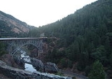
, usually on the opposite side from the Feather River Route; this results in two places where both transportation lines cross the river and each other. The first of these is the Pulga Bridge, an arch bridge
that crosses over a lower railroad truss bridge
; soon after are the highway's three tunnel
s through rock formations in the canyon. After a fair distance through the canyon, and that formed by the East Branch North Fork Feather River, SR 70 reaches the junction with State Route 89
near Paxton
; Routes 70 and 89 overlap southeast from that point, where the East Branch splits into Indian Creek and Spanish Creek. The highway heads southeast, partly along the latter creek, past Keddie
to Quincy
in the American Valley. It leaves the valley via Greenhorn Creek, passing the Feather River Route's Williams Loop
and then following the small Estray Creek to Lee Summit, which the rail line passes under in the Spring Garden Tunnel
. This brings SR 70 into the valley of the Middle Fork Feather River
, which takes it southeast to Blairsden
(where the State Scenic Highway ends and State Route 89 splits to the south) and then east, through the Plumas National Forest
, to Portola
and Beckwourth
. The large Sierra Valley begins at the latter community, and SR 70 heads almost directly across, passing the north end of State Route 49
at Vinton
and the south end of State Route 284
at Chilcoot
before crossing Beckwourth Pass
, which the railroad takes the Chilcoot Tunnel under, and descending slightly to end at U.S. 395 at Hallelujah Junction
.
opened the Beckwourth Trail over Beckwourth Pass
in 1851, crossing the Sierra Nevada at a lower elevation than the existing Donner Pass
route of the California Trail
. This split from the Truckee Route of the California Trail near Reno
and roughly followed the present SR 70 to Quincy
, but, rather than passing through the Feather River Canyon, it followed Oroville-Quincy Highway along ridges to Bidwell's Bar
. A company was incorporated on July 23, 1855 to build the Quincy and Spanish Ranch Wagon Road, which bypassed the older trail from Quincy west to Spanish Ranch
and began collecting toll
s in November. The Pioneer Wagon Road, another toll road, was built in 1856 and 1857, continuing the improvements southwest to Buckeye (just before the Butte County
line). An 1866 law authorized Plumas County
to improve the portion from Quincy east to Beckwourth
. The county also improved the road east from Beckwourth over the pass as part of the Red Clover Wagon Road, which began at Genesee
and was completed in the 1870s.
The Western Pacific Railroad
completed its main line into California in 1909. This followed the old Beckwourth Trail east of Quincy, but to the west it reached Oroville
and Marysville
via the Feather River Canyon. While building the railroad, the Utah Construction Company
had created a dirt road through the canyon to assist with construction; citizens created the Plumas County Road Association in 1911 to push for improvements to this roadway and creation of a year-round route between Oroville and Quincy (the existing route over the ridges was closed for at least four months each winter). The first state highway bond issue, passed by the state's voters in 1910, included a Route 30 connecting Oroville with Quincy. Plumas County
surveyor Arthur W. Keddie surveyed the Feather River Canyon route for the California Highway Commission
in 1913, but the state announced in 1916 that the existing ridge route would be improved. After much debate, the state legislative road committee included the statement that this route would follow the Feather River in the 1919 amendment authorizing a third bond issue; instead of keeping it as Route 30, the Highway Commission changed the designation to an extension of the short Richvale
-Oroville
(now SR 162) Route 21, which was also part of the first bond issue.
Construction began on July 1, 1928, with convict labor for the easier portions and contractor
s for the remainder, as well as bridges and tunnels, but was slowed by the Great Depression
. On the most difficult portion, between Cresta
and Rock Creek, three tunnels had to be built at Arch Rock, Grizzly Dome, and Elephant Butte; at the former two, surveyor
s had to hang out on rope over steep granite
slopes, and rockslide
s repeatedly caused delays. The commission dedicated the road at a ceremony at Grizzly Dome, halfway between the ends, on August 14, 1937. Construction had cost $8.15 million for 78 miles (126 km) of new road. The remainder of the old trail from Quincy to the junction with Route 29 (now U.S. 395) east of Beckwourth Pass was added to the state highway system in 1931 as an extension of Route 21, and was paved by 1936. A new Route 87 was created in 1933, stretching from Woodland
via Marysville
and Oroville
to Route 3 (State Route 99) southeast of Chico
, including the present SR 70 between Marysville and Oroville. Route 87 from Woodland to Oroville and Route 21 from Oroville to east of Beckwourth Pass became a new State Route 24
in 1934; State Route 24 was extended southwest from Woodland to Oakland
by the end of 1937.
In 1954, the original part of State Route 24 was replaced by U.S. Route 40 Alternate, which continued south on U.S. 99W from Woodland to Davis
and southeast on U.S. 395
to Reno, Nevada
to join U.S. 40
at both ends. A direct route from Marysville south to Sacramento
was added to the state highway system in 1949 as Route 232, and later became part of a rerouted State Route 24. The U.S. 40 Alternate designation was short-lived, and was mostly replaced by State Route 70 in the 1964 renumbering. Southwest of Marysville, former U.S. 40 Alternate instead became State Route 113
, and SR 70 ran south along former State Route 24 (Route 232) to a point north of Sacramento, where the new State Route 99
came in from the northwest and continued south. Despite SR 70 always ending at State Route 99, it was once signed along State Route 99 (El Centro Road, Garden Highway, and the Jibboom Street Bridge
) to Sacramento.
When it was originally built, the Feather River Highway northeast from Oroville followed the present Oroville Dam Boulevard (County Route B2) to the present location of the Oroville Dam
, and then ran north and northeast alongside the North Fork Feather River along a route now covered by Lake Oroville
. It left to the north on Dark Canyon Road, meeting the present alignment at Jarbo Gap. Since the old road would be flooded, a $14.8 million new alignment, much of it four lanes, was built around the west side; the Western Pacific Railroad was also relocated to a nearby alignment. The double-decker West Branch Bridge over the West Branch Feather River
northwest of the dam, carrying the highway above the rail line, was dedicated on August 15, 1962. Two portions of SR 70 have been upgraded to freeways: south from Marysville
to the State Route 65
split in the mid-1950s, extended farther south in the late 1960s; and around downtown Oroville
, built in the early 1960s. In 2004, SR 70 was upgraded to a four-lane expressway between Feather River Boulevard north of the Bear River
and the Yuba
/Sutter
county line to the freeway portion south of McGowan Parkway. A freeway interchange was constructed in 2008 at Plumas Lake Boulevard for access to the Plumas Lake
development previously served at an uncontrolled intersection with Plumas Arboga Road.
{| class=wikitable
!County
!Location
!Postmile
!Exit
!Destinations
!Notes
|-
|rowspan=3|Sutter
SUT R0.05-8.30
|
|R0.05
|
|
|Interchange; southbound exit and northbound entrance
|-
|
|
|
| Striplin Road to SR 99
north – Yuba City
|
|-
|East Nicolaus
|
|4
|Nicolaus Avenue
|Interchange
|-
|rowspan=13|Yuba
YUB 0.00-25.82
|rowspan=3|Plumas Lake
|R0.35
|
|Feather River Boulevard
|
|-
|colspan=4 align=center|South end of freeway
|-
|
|12
|Plumas Lake Boulevard
|
|-
|rowspan=3|Olivehurst
|R7.35
|16
|McGowan Parkway
|
|-bgcolor=#ffdddd
|R8.29
|17
|
|Southbound left exit and northbound entrance
|-
|R9.28
|18A
|Olivehurst
(Olivehurst Avenue)
|
|-
|rowspan=3|Linda
|R10.16
|18B
|Erle Road
|
|-
|R11.39
13.01
|20A
|Feather River Boulevard
|Serves Beale AFB
, Yuba College
(northbound only)
|-bgcolor=#ffdddd
|13.23
|20B
|North Beale Road
|No southbound entrance; serves Beale AFB
, Yuba College
|-
|rowspan=4|Marysville
|bgcolor=#ffdddd|14.08
|bgcolor=#ffdddd|
|bgcolor=#ffdddd|1st Street, F Street
|bgcolor=#ffdddd|Southbound entrance only
|-
|14.25
|colspan=3 align=center|North end of freeway
|-bgcolor=#ddffdd
|14.70
0.99Indicates that the postmile represents the distance along SR 20 rather than SR 70.
|
|
|South end of SR 20 overlap
|-bgcolor=#ddffdd
|1.47
14.71
|
|
|North end of SR 20 overlap
|-
|rowspan=14|Butte
BUT 0.00-48.08
|
|1.01
|
|Lower Honcut Road – Honcut
, Bangor
, Rackerby
|
|-
|
|4.06
|
|East Gridley Road, Stimpson Road
|
|-
|
|9.06
|
|Palermo Road, Welsh Road – Palermo
|
|-
|rowspan=4|Oroville
|colspan=4 align=center|South end of freeway
|-
|13.90
|46
|
|
|-
|14.61
|47
|
|
|-
|15.43-
15.72
|48
|Grand Avenue, Nelson Avenue
|
|-
|
|16.63
|49
|Garden Drive (SR 70 Bus. west)
|
|-
|Wicks Corner
|20.48
|
|
|
|-
|colspan=5 align=center|North end of freeway
|-
|
|21.87
|
|
|
|-
|
|26.47
|
|Pentz Road – Paradise
, Chico
|
|-
|
|28.22
|colspan=3 align=center|West Branch Bridge over West Branch Feather River
|-
|
|40.99
|colspan=3 align=center|Pulga Bridge over North Fork Feather River
|-
|rowspan=7|Plumas
PLU 0.00-95.96
|
|bgcolor=#ddffdd|33.03
|bgcolor=#ddffdd|
|bgcolor=#ddffdd|
|bgcolor=#ddffdd|West end of SR 89 overlap
|-
|Blairsden
|bgcolor=#ddffdd|R66.63
|bgcolor=#ddffdd|
|bgcolor=#ddffdd|
|bgcolor=#ddffdd|East end of SR 89 overlap
|-
|Portola
|75.96
|
|
|
|-
|Beckwourth
|R80.32
|
|
|
|-
|
|83
|
|
|
|-
|Vinton
|92.07
|
|
|
|-
|Chilcoot
|94.28
|
|
|
|-
|Lassen
LAS 0.00-3.89
|Hallelujah Junction
|3.89
|
| – Reno
, Susanville
|Interchange
State highway
State highway, state road or state route can refer to one of three related concepts, two of them related to a state or provincial government in a country that is divided into states or provinces :#A...
in the U.S. state
U.S. state
A U.S. state is any one of the 50 federated states of the United States of America that share sovereignty with the federal government. Because of this shared sovereignty, an American is a citizen both of the federal entity and of his or her state of domicile. Four states use the official title of...
of California
California
California is a state located on the West Coast of the United States. It is by far the most populous U.S. state, and the third-largest by land area...
. Connecting Sacramento
Sacramento, California
Sacramento is the capital city of the U.S. state of California and the county seat of Sacramento County. It is located at the confluence of the Sacramento River and the American River in the northern portion of California's expansive Central Valley. With a population of 466,488 at the 2010 census,...
with U.S. Route 395 near Beckwourth Pass
Beckwourth Pass
Beckwourth Pass is the lowest Sierra Crest mountain pass and is located at the Sierra Valley's eastern edge near Chilcoot-Vinton, Plumas County, California. Beckwourth Pass is east of Beckwourth, California, in the Sierra Nevada, and is northwest of Reno, Nevada. The pass carries California State...
(elevation 5221 feet/1591 m, lowest in the Sierra Nevada) via the Feather River Canyon, it was formerly known as U.S. Route 40 Alternate, crossing the Sierra Nevada at a lower elevation than Donner Pass
Donner Pass
Donner Pass is a mountain pass in the northern Sierra Nevada, located above Donner Lake about nine miles west of Truckee, California. It has a steep approach from the east and a gradual approach from the west....
on U.S. Route 40 (now Interstate 80). Through the Feather River Canyon, from State Route 149
California State Route 149
State Route 149 is a short state highway that helps to connect Oroville and Chico through rural Butte County. Connecting State Route 70 at Wicks Corner with State Route 99 east of Durham, it forms part of the primary north–south highway through the eastern Sacramento Valley, a Focus Route of...
to U.S. 395, SR 70 is the Feather River Scenic Byway, a Forest Service Byway that parallels the ex-Western Pacific Railroad
Western Pacific Railroad
The Western Pacific Railroad was a Class I railroad in the United States. It was formed in 1903 as an attempt to break the near-monopoly the Southern Pacific Railroad had on rail service into northern California...
Feather River Route
Feather River Route
The Feather River Route is a rail line that was built and operated by the Western Pacific Railroad. It was constructed between 1906 and 1909, and connects the cities of Oakland, California, and Salt Lake City, Utah...
.
Route description
The portion of SR 70 west of State Route 89California State Route 89
State Route 89 is a California State Highway that travels in the north–south direction, and is the major thoroughfare for many mountain communities. It starts from U.S. Route 395 near Topaz Lake, winding its way up to the Monitor Pass, down to the Carson River, and up again over the Luther...
near Blairsden
Blairsden, California
Blairsden is a census-designated place in Plumas County, California, United States. Blairsden is located east-southeast of Quincy. The population was 39 at the 2010 census, down from 50 at the 2000 census.-History:...
is also eligible for the State Scenic Highway System
State Scenic Highway System (California)
The State Scenic Highway System is a list of highways, mainly state highways, that have been designated by the California Department of Transportation as scenic highways. The California State Legislature, primarily through Section 263 of the Streets and Highways Code, makes highways eligible for...
, but has not been designated as such by Caltrans. The entire route is part of the California Freeway and Expressway System
California Freeway and Expressway System
The California Freeway and Expressway System is a system of existing or planned freeways and expressways in the U.S. state of California. It is defined by the Streets and Highways Code.-List of roads in the system:*State Route 1 *State Route 2...
, though it is mostly two lanes.
State Route 70 begins at a partial interchange
Interchange (road)
In the field of road transport, an interchange is a road junction that typically uses grade separation, and one or more ramps, to permit traffic on at least one highway to pass through the junction without directly crossing any other traffic stream. It differs from a standard intersection, at which...
with State Route 99
California State Route 99
California State Route 99 , commonly known as Highway 99 or, simply, as 99 , is a north–south state highway in the U.S. state of California, stretching almost the entire length of the Central Valley...
north of Sacramento
Sacramento, California
Sacramento is the capital city of the U.S. state of California and the county seat of Sacramento County. It is located at the confluence of the Sacramento River and the American River in the northern portion of California's expansive Central Valley. With a population of 466,488 at the 2010 census,...
, close to the Feather River Route
Feather River Route
The Feather River Route is a rail line that was built and operated by the Western Pacific Railroad. It was constructed between 1906 and 1909, and connects the cities of Oakland, California, and Salt Lake City, Utah...
rail line that parallels the entire highway, and heads north along a two-lane surface road. Just north of the Bear River crossing / Yuba County line, in Plumas Lake
Plumas Lake, California
Plumas Lake is a master-planned exurb and census-designated place in Yuba County, California. Plumas Lake is located north of the city of Sacramento on the Feather River, just prior to its confluence with the Bear River and the Sacramento River...
, SR 70 becomes a freeway, which continues to just beyond the Yuba River
Yuba River
The Yuba River is a tributary of the Feather River in the Sacramento Valley of the U.S. state of California. It is one of the Feather's most important branches, providing about a third of its flow. The main stem of the river is about long, and its headwaters are split into North, Middle and South...
in Marysville
Marysville, California
Marysville is the county seat of Yuba County, California, United States. The population was 12,072 at the 2010 census, down from 12,268 at the 2000 census. It is included in the Yuba City Metropolitan Statistical Area, often referred to as the Yuba-Sutter Area after the two counties, Yuba and...
. Within that city, SR 70 makes two turns and overlaps State Route 20 before leaving to the north on a two-lane road. Another four-lane freeway begins south of State Route 162 in Oroville
Oroville, California
Oroville is the county seat of Butte County, California. The population was 15,506 at the 2010 census, up from 13,004 at the 2000 census...
, and ends at State Route 149
California State Route 149
State Route 149 is a short state highway that helps to connect Oroville and Chico through rural Butte County. Connecting State Route 70 at Wicks Corner with State Route 99 east of Durham, it forms part of the primary north–south highway through the eastern Sacramento Valley, a Focus Route of...
. State Route 149 is a major connection northwest to State Route 99
California State Route 99
California State Route 99 , commonly known as Highway 99 or, simply, as 99 , is a north–south state highway in the U.S. state of California, stretching almost the entire length of the Central Valley...
, and became the straight-through movement when the construction to replace the intersection with an interchange was completed in November 2008. The State Scenic Highway portion of SR 70 begins at State Route 149, which is where SR 70 turns northeast out of the Sacramento Valley
Sacramento Valley
The Sacramento Valley is the portion of the California Central Valley that lies to the north of the San Joaquin-Sacramento Delta in the U.S. state of California. It encompasses all or parts of ten counties.-Geography:...
and into the mountains. The short State Route 191 spurs north to Paradise
Paradise, California
Paradise is an incorporated town in Butte County, in the northwest foothills of California's Central Valley, in the Sierra. The town is considered part of the Chico Metropolitan Area. The population was 26,218 at the 2010 census, down from 26,408 at the 2000 census...
, and SR 70 crosses the West Branch Feather River
West Branch Feather River
The West Branch Feather River is a Lake Oroville tributary that flows generally north-to-south in the North Fork Feather Watershed near the watershed's drainage divide with the...
on the double-decker West Branch Bridge, with the Feather River Route below. A short four-lane section runs over the bridge towards Jarbo Gap, where the present SR 70 merges with the old road (Dark Canyon Road) that was used before the Feather River was dam
Dam
A dam is a barrier that impounds water or underground streams. Dams generally serve the primary purpose of retaining water, while other structures such as floodgates or levees are used to manage or prevent water flow into specific land regions. Hydropower and pumped-storage hydroelectricity are...
med to create Lake Oroville
Lake Oroville
Lake Oroville, also known as Lake Edmonston, is a reservoir in the U.S. state of California, formed by the Oroville Dam across the Feather River. The lake is situated in the foothills of the Sierra Nevada about northeast of Oroville. At over , it is one of the largest reservoirs in California,...
in the 1960s.
North Fork Feather River
The North Fork Feather River is a watercourse of the northern Sierra Nevada in the U.S. state of California. It flows generally southwards from its headwaters near Lassen Peak to Lake Oroville, a reservoir formed by Oroville Dam in the foothills of the Sierra, where it runs into the Feather River....
, which it follows almost to Quincy
Quincy, California
Quincy is a census-designated place and the county seat of Plumas County, California. The population was 1,728 at the 2010 census, down from 1,879 at the 2000 census. Quincy is named after the city of Quincy, Illinois...
, usually on the opposite side from the Feather River Route; this results in two places where both transportation lines cross the river and each other. The first of these is the Pulga Bridge, an arch bridge
Arch bridge
An arch bridge is a bridge with abutments at each end shaped as a curved arch. Arch bridges work by transferring the weight of the bridge and its loads partially into a horizontal thrust restrained by the abutments at either side...
that crosses over a lower railroad truss bridge
Truss bridge
A truss bridge is a bridge composed of connected elements which may be stressed from tension, compression, or sometimes both in response to dynamic loads. Truss bridges are one of the oldest types of modern bridges...
; soon after are the highway's three tunnel
Tunnel
A tunnel is an underground passageway, completely enclosed except for openings for egress, commonly at each end.A tunnel may be for foot or vehicular road traffic, for rail traffic, or for a canal. Some tunnels are aqueducts to supply water for consumption or for hydroelectric stations or are sewers...
s through rock formations in the canyon. After a fair distance through the canyon, and that formed by the East Branch North Fork Feather River, SR 70 reaches the junction with State Route 89
California State Route 89
State Route 89 is a California State Highway that travels in the north–south direction, and is the major thoroughfare for many mountain communities. It starts from U.S. Route 395 near Topaz Lake, winding its way up to the Monitor Pass, down to the Carson River, and up again over the Luther...
near Paxton
Paxton, California
Paxton is a census-designated place in Plumas County, California, United States. The population was 14 at the 2010 census, down from 21 at the 2000 census.-Geography:Paxton is located at ....
; Routes 70 and 89 overlap southeast from that point, where the East Branch splits into Indian Creek and Spanish Creek. The highway heads southeast, partly along the latter creek, past Keddie
Keddie, California
Keddie is a census-designated place in Plumas County, California, United States. The population was 66 at the 2010 census.-Geography:Keddie is located at ....
to Quincy
Quincy, California
Quincy is a census-designated place and the county seat of Plumas County, California. The population was 1,728 at the 2010 census, down from 1,879 at the 2000 census. Quincy is named after the city of Quincy, Illinois...
in the American Valley. It leaves the valley via Greenhorn Creek, passing the Feather River Route's Williams Loop
Williams Loop
The Williams Loop is a rail spiral located on the Union Pacific Railroad's Feather River Route through the Sierra Nevada Mountains in north eastern California, connecting the Sacramento Valley to Salt Lake City via the Feather River valley...
and then following the small Estray Creek to Lee Summit, which the rail line passes under in the Spring Garden Tunnel
Spring Garden Tunnel
The Spring Garden Tunnel at in Spring Garden, California is the longest of 34 tunnels of the Feather River Route The Spring Garden Tunnel at in Spring Garden, California is the longest of 34 tunnels of the Feather River Route The Spring Garden Tunnel at in Spring Garden, California is the...
. This brings SR 70 into the valley of the Middle Fork Feather River
Middle Fork Feather River
The Middle Fork Feather River is a major river in Plumas and Butte Counties in the U.S. state of California. Nearly long, it drains about of the rugged northern Sierra Nevada range....
, which takes it southeast to Blairsden
Blairsden, California
Blairsden is a census-designated place in Plumas County, California, United States. Blairsden is located east-southeast of Quincy. The population was 39 at the 2010 census, down from 50 at the 2000 census.-History:...
(where the State Scenic Highway ends and State Route 89 splits to the south) and then east, through the Plumas National Forest
Plumas National Forest
Plumas National Forest is a 1,146,000-acre United States National Forest located in the Sierra Nevada, in northern California.-Geography:...
, to Portola
Portola, California
Portola is the only incorporated city in Plumas County, California, United States. The population was 2,104 at the 2010 census, down from 2,227 at the 2000 census...
and Beckwourth
Beckwourth, California
Beckwourth is a census-designated place in Plumas County, California, United States. Beckwourth is located on the Middle Fork Feather River east of Portola...
. The large Sierra Valley begins at the latter community, and SR 70 heads almost directly across, passing the north end of State Route 49
California State Route 49
State Route 49 is a north–south state highway in the U.S. state of California that passes through many historic mining communities of the 1849 California gold rush. Highway 49 is numbered after the "49ers", the waves of immigrants who swept into the area looking for gold, and a portion of it...
at Vinton
Vinton, California
Vinton is an unincorporated community in Plumas County, California. It lies at an elevation of . Vinton is located west of Chilcoot.For census purposes, Vinton is included in the census-designated place of Vinton-Vinton....
and the south end of State Route 284
California State Route 284
State Route 284 is a short state highway in Plumas County, California. It is a spur route off from State Route 70 in Chilcoot connecting to Frenchman Lake.-Route description:The route begins at State Route 70 at Chilcoot...
at Chilcoot
Chilcoot, California
Chilcoot is an unincorporated community in Plumas County, California. It lies at an elevation of . Chilcoot is located east of Portola.For census purposes, Chilcoot is included in the census-designated place of Chilcoot-Vinton....
before crossing Beckwourth Pass
Beckwourth Pass
Beckwourth Pass is the lowest Sierra Crest mountain pass and is located at the Sierra Valley's eastern edge near Chilcoot-Vinton, Plumas County, California. Beckwourth Pass is east of Beckwourth, California, in the Sierra Nevada, and is northwest of Reno, Nevada. The pass carries California State...
, which the railroad takes the Chilcoot Tunnel under, and descending slightly to end at U.S. 395 at Hallelujah Junction
Hallelujah Junction, California
Hallelujah Junction is an unincorporated community in Lassen County, California. It is located east-southeast of Beckwourth Pass, at an elevation of 5033 feet . It is located at the interchange with U.S...
.
History
James BeckwourthJames Beckwourth
James Pierson Beckwourth was an American mountain man, fur trader, and explorer. An African American mulatto born into slavery in Virginia, he later moved to the American West. As a fur trapper, he lived with the Crow for years...
opened the Beckwourth Trail over Beckwourth Pass
Beckwourth Pass
Beckwourth Pass is the lowest Sierra Crest mountain pass and is located at the Sierra Valley's eastern edge near Chilcoot-Vinton, Plumas County, California. Beckwourth Pass is east of Beckwourth, California, in the Sierra Nevada, and is northwest of Reno, Nevada. The pass carries California State...
in 1851, crossing the Sierra Nevada at a lower elevation than the existing Donner Pass
Donner Pass
Donner Pass is a mountain pass in the northern Sierra Nevada, located above Donner Lake about nine miles west of Truckee, California. It has a steep approach from the east and a gradual approach from the west....
route of the California Trail
California Trail
The California Trail was an emigrant trail of about across the western half of the North American continent from Missouri River towns to what is now the state of California...
. This split from the Truckee Route of the California Trail near Reno
Reno, Nevada
Reno is the county seat of Washoe County, Nevada, United States. The city has a population of about 220,500 and is the most populous Nevada city outside of the Las Vegas metropolitan area...
and roughly followed the present SR 70 to Quincy
Quincy, California
Quincy is a census-designated place and the county seat of Plumas County, California. The population was 1,728 at the 2010 census, down from 1,879 at the 2000 census. Quincy is named after the city of Quincy, Illinois...
, but, rather than passing through the Feather River Canyon, it followed Oroville-Quincy Highway along ridges to Bidwell's Bar
Bidwell's Bar, California
Bidwell's Bar was a gold mining camp in Butte County, California, United States, which lay at the end of the California Trail...
. A company was incorporated on July 23, 1855 to build the Quincy and Spanish Ranch Wagon Road, which bypassed the older trail from Quincy west to Spanish Ranch
Spanish Ranch, California
Spanish Ranch is an unincorporated community in Plumas County, California. It lies at an elevation of 3668 feet . Spanish Ranch is located north- northeast of Meadow Valley....
and began collecting toll
Toll road
A toll road is a privately or publicly built road for which a driver pays a toll for use. Structures for which tolls are charged include toll bridges and toll tunnels. Non-toll roads are financed using other sources of revenue, most typically fuel tax or general tax funds...
s in November. The Pioneer Wagon Road, another toll road, was built in 1856 and 1857, continuing the improvements southwest to Buckeye (just before the Butte County
Butte County, California
Butte County is a county located in the Central Valley of the US state of California, north of the state capital of Sacramento. As of the 2010 census, it had a population of 220,000. The county seat is Oroville. Butte County is the "Land of Natural Wealth and Beauty."Butte County is watered by the...
line). An 1866 law authorized Plumas County
Plumas County, California
Plumas County is a county located in the Sierra Nevada of the U.S. state of California. The county gets its name from the Spanish words for the Feather River , which flows through the county. As of the 2010 census, the population 20,007, down from 20,824 at the 2000 census...
to improve the portion from Quincy east to Beckwourth
Beckwourth, California
Beckwourth is a census-designated place in Plumas County, California, United States. Beckwourth is located on the Middle Fork Feather River east of Portola...
. The county also improved the road east from Beckwourth over the pass as part of the Red Clover Wagon Road, which began at Genesee
Genesee, California
Genesee is an unincorporated community in Plumas County, California. It lies at an elevation of 3701 feet . Genesee is located east-southeast of Taylorsville....
and was completed in the 1870s.
The Western Pacific Railroad
Western Pacific Railroad
The Western Pacific Railroad was a Class I railroad in the United States. It was formed in 1903 as an attempt to break the near-monopoly the Southern Pacific Railroad had on rail service into northern California...
completed its main line into California in 1909. This followed the old Beckwourth Trail east of Quincy, but to the west it reached Oroville
Oroville, California
Oroville is the county seat of Butte County, California. The population was 15,506 at the 2010 census, up from 13,004 at the 2000 census...
and Marysville
Marysville, California
Marysville is the county seat of Yuba County, California, United States. The population was 12,072 at the 2010 census, down from 12,268 at the 2000 census. It is included in the Yuba City Metropolitan Statistical Area, often referred to as the Yuba-Sutter Area after the two counties, Yuba and...
via the Feather River Canyon. While building the railroad, the Utah Construction Company
Utah Construction Company
The Utah Construction Company was a construction company founded by Edmund Orson Wattis, Jr, Warren L. Wattis and William. H. Wattis in 1900.-History:...
had created a dirt road through the canyon to assist with construction; citizens created the Plumas County Road Association in 1911 to push for improvements to this roadway and creation of a year-round route between Oroville and Quincy (the existing route over the ridges was closed for at least four months each winter). The first state highway bond issue, passed by the state's voters in 1910, included a Route 30 connecting Oroville with Quincy. Plumas County
Plumas County, California
Plumas County is a county located in the Sierra Nevada of the U.S. state of California. The county gets its name from the Spanish words for the Feather River , which flows through the county. As of the 2010 census, the population 20,007, down from 20,824 at the 2000 census...
surveyor Arthur W. Keddie surveyed the Feather River Canyon route for the California Highway Commission
California Highway Commission
The California Highway Commission was established in 1895 and continued until 1978 as the primary state highway bureaucracy in California.Their first noticeable efforts centered on the Lake Tahoe Wagon Road over the Sierra Nevada mountains...
in 1913, but the state announced in 1916 that the existing ridge route would be improved. After much debate, the state legislative road committee included the statement that this route would follow the Feather River in the 1919 amendment authorizing a third bond issue; instead of keeping it as Route 30, the Highway Commission changed the designation to an extension of the short Richvale
Richvale, California
Richvale is a small census-designated place in Butte County, California, USA, south of Chico and west of Oroville. The primary crop grown in the area surrounding Richvale is rice, irrigated from the Oroville Dam on the Feather River. Several farmers in the area are known for organic farming...
-Oroville
Oroville, California
Oroville is the county seat of Butte County, California. The population was 15,506 at the 2010 census, up from 13,004 at the 2000 census...
(now SR 162) Route 21, which was also part of the first bond issue.
Construction began on July 1, 1928, with convict labor for the easier portions and contractor
General contractor
A general contractor is responsible for the day-to-day oversight of a construction site, management of vendors and trades, and communication of information to involved parties throughout the course of a building project.-Description:...
s for the remainder, as well as bridges and tunnels, but was slowed by the Great Depression
Great Depression
The Great Depression was a severe worldwide economic depression in the decade preceding World War II. The timing of the Great Depression varied across nations, but in most countries it started in about 1929 and lasted until the late 1930s or early 1940s...
. On the most difficult portion, between Cresta
Cresta, California
Cresta is an unincorporated community in Butte County, California. It lies northeast of Pulga on the Western Pacific Railroad, at an elevation of 1581 feet ....
and Rock Creek, three tunnels had to be built at Arch Rock, Grizzly Dome, and Elephant Butte; at the former two, surveyor
Surveying
See Also: Public Land Survey SystemSurveying or land surveying is the technique, profession, and science of accurately determining the terrestrial or three-dimensional position of points and the distances and angles between them...
s had to hang out on rope over steep granite
Granite
Granite is a common and widely occurring type of intrusive, felsic, igneous rock. Granite usually has a medium- to coarse-grained texture. Occasionally some individual crystals are larger than the groundmass, in which case the texture is known as porphyritic. A granitic rock with a porphyritic...
slopes, and rockslide
Rockslide
A rockslide is a type of landslide caused by rock failure in which part of the plane of failure passes through intact rock and where material collapses en masse and not in individual blocks.The mode of failure is different from that of a rock-fall....
s repeatedly caused delays. The commission dedicated the road at a ceremony at Grizzly Dome, halfway between the ends, on August 14, 1937. Construction had cost $8.15 million for 78 miles (126 km) of new road. The remainder of the old trail from Quincy to the junction with Route 29 (now U.S. 395) east of Beckwourth Pass was added to the state highway system in 1931 as an extension of Route 21, and was paved by 1936. A new Route 87 was created in 1933, stretching from Woodland
Woodland, California
Woodland is the county seat of Yolo County, California, located approximately northwest of Sacramento, and is a part of the Sacramento - Arden-Arcade - Roseville Metropolitan Statistical Area. The population was 55,468 at the 2010 census.Woodland's origins trace back to 1850 when California...
via Marysville
Marysville, California
Marysville is the county seat of Yuba County, California, United States. The population was 12,072 at the 2010 census, down from 12,268 at the 2000 census. It is included in the Yuba City Metropolitan Statistical Area, often referred to as the Yuba-Sutter Area after the two counties, Yuba and...
and Oroville
Oroville, California
Oroville is the county seat of Butte County, California. The population was 15,506 at the 2010 census, up from 13,004 at the 2000 census...
to Route 3 (State Route 99) southeast of Chico
Chico, California
Chico is the most populous city in Butte County, California, United States. The population was 86,187 at the 2010 census, up from 59,954 at the time of the 2000 census...
, including the present SR 70 between Marysville and Oroville. Route 87 from Woodland to Oroville and Route 21 from Oroville to east of Beckwourth Pass became a new State Route 24
California State Route 24
State Route 24 in the U.S. state of California is a heavily-traveled east–west freeway in the eastern side of the San Francisco Bay Area of northern California that runs from the Interstate 580/Interstate 980 interchange in Oakland to the Interstate 680 junction in Walnut Creek...
in 1934; State Route 24 was extended southwest from Woodland to Oakland
Oakland, California
Oakland is a major West Coast port city on San Francisco Bay in the U.S. state of California. It is the eighth-largest city in the state with a 2010 population of 390,724...
by the end of 1937.
In 1954, the original part of State Route 24 was replaced by U.S. Route 40 Alternate, which continued south on U.S. 99W from Woodland to Davis
Davis, California
Davis is a city in Yolo County, California, United States. It is part of the Sacramento–Arden-Arcade–Roseville Metropolitan Statistical Area...
and southeast on U.S. 395
U.S. Route 395
U.S. Route 395 is a U.S. Route in the western United States. The southern terminus of the route is in the Mojave Desert at Interstate 15 near Hesperia. The northern terminus is at the Canadian border near Laurier, where the road becomes Highway 395 upon entering British Columbia. At one time, the...
to Reno, Nevada
Reno, Nevada
Reno is the county seat of Washoe County, Nevada, United States. The city has a population of about 220,500 and is the most populous Nevada city outside of the Las Vegas metropolitan area...
to join U.S. 40
U.S. Route 40
U.S. Route 40 is an east–west United States highway. As with most routes whose numbers end in a zero, U.S. 40 once traversed the entire United States. It is one of the original 1920s U.S. Highways, and its first termini were San Francisco, California, and Atlantic City, New Jersey...
at both ends. A direct route from Marysville south to Sacramento
Sacramento, California
Sacramento is the capital city of the U.S. state of California and the county seat of Sacramento County. It is located at the confluence of the Sacramento River and the American River in the northern portion of California's expansive Central Valley. With a population of 466,488 at the 2010 census,...
was added to the state highway system in 1949 as Route 232, and later became part of a rerouted State Route 24. The U.S. 40 Alternate designation was short-lived, and was mostly replaced by State Route 70 in the 1964 renumbering. Southwest of Marysville, former U.S. 40 Alternate instead became State Route 113
California State Route 113
State Route 113 is a north–south state highway in the U.S. state of California that runs from around west of Rio Vista at State Route 12 to State Route 99 south of Yuba City. It is an important connecting route between Interstate 80 and Interstate 5. Past the southern terminus are...
, and SR 70 ran south along former State Route 24 (Route 232) to a point north of Sacramento, where the new State Route 99
California State Route 99
California State Route 99 , commonly known as Highway 99 or, simply, as 99 , is a north–south state highway in the U.S. state of California, stretching almost the entire length of the Central Valley...
came in from the northwest and continued south. Despite SR 70 always ending at State Route 99, it was once signed along State Route 99 (El Centro Road, Garden Highway, and the Jibboom Street Bridge
Jibboom Street Bridge
The Jibboom Street Bridge is a historic metal truss swing bridge located on Jibboom Street in Sacramento, California crossing the American River in Sacramento County, built in 1931. The main swing span is flanked by two Parker through truss spans....
) to Sacramento.
When it was originally built, the Feather River Highway northeast from Oroville followed the present Oroville Dam Boulevard (County Route B2) to the present location of the Oroville Dam
Oroville Dam
Oroville Dam spans the Feather River about northeast of the city of Oroville, California. It forms Lake Oroville, which stores water for irrigation, flood control, municipal water supply and hydroelectricity generation in California's Sacramento Valley. The dam lies in the foothills of the Sierra...
, and then ran north and northeast alongside the North Fork Feather River along a route now covered by Lake Oroville
Lake Oroville
Lake Oroville, also known as Lake Edmonston, is a reservoir in the U.S. state of California, formed by the Oroville Dam across the Feather River. The lake is situated in the foothills of the Sierra Nevada about northeast of Oroville. At over , it is one of the largest reservoirs in California,...
. It left to the north on Dark Canyon Road, meeting the present alignment at Jarbo Gap. Since the old road would be flooded, a $14.8 million new alignment, much of it four lanes, was built around the west side; the Western Pacific Railroad was also relocated to a nearby alignment. The double-decker West Branch Bridge over the West Branch Feather River
West Branch Feather River
The West Branch Feather River is a Lake Oroville tributary that flows generally north-to-south in the North Fork Feather Watershed near the watershed's drainage divide with the...
northwest of the dam, carrying the highway above the rail line, was dedicated on August 15, 1962. Two portions of SR 70 have been upgraded to freeways: south from Marysville
Marysville, California
Marysville is the county seat of Yuba County, California, United States. The population was 12,072 at the 2010 census, down from 12,268 at the 2000 census. It is included in the Yuba City Metropolitan Statistical Area, often referred to as the Yuba-Sutter Area after the two counties, Yuba and...
to the State Route 65
California State Route 65
State Route 65 , commonly known as Highway 65, is a north–south state highway in the U.S. state of California composed of two segments connecting Bakersfield to Exeter and Roseville to Olivehurst...
split in the mid-1950s, extended farther south in the late 1960s; and around downtown Oroville
Oroville, California
Oroville is the county seat of Butte County, California. The population was 15,506 at the 2010 census, up from 13,004 at the 2000 census...
, built in the early 1960s. In 2004, SR 70 was upgraded to a four-lane expressway between Feather River Boulevard north of the Bear River
Bear River (Feather River tributary)
The Bear River is a tributary of the Feather River in the Sierra Nevada, winding through four California counties: Yuba, Sutter, Placer, and Nevada....
and the Yuba
Yuba County, California
Yuba County is a county located in the U.S. state of California's Central Valley, north of Sacramento, along the Feather River. As of the 2010 census, its population was 72,155. The county seat is Marysville. Yuba County is part of the Greater Sacramento area.-History:Yuba County was one of the...
/Sutter
Sutter County, California
Sutter County is a county located along the Sacramento River in the Central Valley of the U.S. state of California, north of state capital Sacramento. Sutter County is part of the Greater Sacramento CSA....
county line to the freeway portion south of McGowan Parkway. A freeway interchange was constructed in 2008 at Plumas Lake Boulevard for access to the Plumas Lake
Plumas Lake, California
Plumas Lake is a master-planned exurb and census-designated place in Yuba County, California. Plumas Lake is located north of the city of Sacramento on the Feather River, just prior to its confluence with the Bear River and the Sacramento River...
development previously served at an uncontrolled intersection with Plumas Arboga Road.
Major intersections
- Note: Except where prefixed with a letter, postmiles were measured in 1964, based on the alignment as it existed at that time, and do not necessarily reflect current mileage. The numbers reset at county lines; the start and end postmiles in each county are given in the county column. The portion of the route from State Route 99 to State Route 149 is signed as a north–south route.
{| class=wikitable
!County
!Location
!Postmile
!Exit
Exit number
An exit number is a number assigned to a road junction, usually an exit from a freeway. It is usually marked on the same sign as the destinations of the exit, as well as a sign in the gore....
!Destinations
!Notes
|-
|rowspan=3|Sutter
Sutter County, California
Sutter County is a county located along the Sacramento River in the Central Valley of the U.S. state of California, north of state capital Sacramento. Sutter County is part of the Greater Sacramento CSA....
SUT R0.05-8.30
|
|R0.05
|
|
|Interchange; southbound exit and northbound entrance
|-
|
|
|
|
California State Route 99
California State Route 99 , commonly known as Highway 99 or, simply, as 99 , is a north–south state highway in the U.S. state of California, stretching almost the entire length of the Central Valley...
north – Yuba City
Yuba City, California
Yuba City is a Northern California city, founded in 1849. It is the county seat of Sutter County, California, United States. The population was 64,925 at the 2010 census....
|
|-
|East Nicolaus
East Nicolaus, California
East Nicolaus is a census-designated place in Sutter County, California. East Nicolaus sits at an elevation of . The 2010 United States census reported East Nicolaus's population was 225.-Geography:...
|
|4
|Nicolaus Avenue
|Interchange
|-
|rowspan=13|Yuba
Yuba County, California
Yuba County is a county located in the U.S. state of California's Central Valley, north of Sacramento, along the Feather River. As of the 2010 census, its population was 72,155. The county seat is Marysville. Yuba County is part of the Greater Sacramento area.-History:Yuba County was one of the...
YUB 0.00-25.82
|rowspan=3|Plumas Lake
Plumas Lake, California
Plumas Lake is a master-planned exurb and census-designated place in Yuba County, California. Plumas Lake is located north of the city of Sacramento on the Feather River, just prior to its confluence with the Bear River and the Sacramento River...
|R0.35
|
|Feather River Boulevard
|
|-
|colspan=4 align=center|South end of freeway
|-
|
|12
|Plumas Lake Boulevard
|
|-
|rowspan=3|Olivehurst
Olivehurst, California
Olivehurst is a census-designated place in Yuba County, California, United States. The population was 13,656 at the 2010 census, up from 11,061 at the 2000 census...
|R7.35
|16
|McGowan Parkway
|
|-bgcolor=#ffdddd
|R8.29
|17
|
|Southbound left exit and northbound entrance
|-
|R9.28
|18A
|Olivehurst
Olivehurst, California
Olivehurst is a census-designated place in Yuba County, California, United States. The population was 13,656 at the 2010 census, up from 11,061 at the 2000 census...
(Olivehurst Avenue)
|
|-
|rowspan=3|Linda
Linda, California
Linda is a census-designated place in Yuba County, California, United States. The population was 17,773 at the 2010 census, up from 13,474 at the 2000 census...
|R10.16
|18B
|Erle Road
|
|-
|R11.39
13.01
|20A
|Feather River Boulevard
|Serves Beale AFB
Beale Air Force Base
Beale Air Force Base is a United States Air Force base located approximately east of Marysville, California. Originally known as Camp Beale....
, Yuba College
Yuba College
Yuba College is the main campus for the Yuba Community College District in Marysville, California, USA. It also has extension campuses in Woodland, California and Clearlake, California as well as offering some classes in Colusa, California and Beale AFB....
(northbound only)
|-bgcolor=#ffdddd
|13.23
|20B
|North Beale Road
|No southbound entrance; serves Beale AFB
Beale Air Force Base
Beale Air Force Base is a United States Air Force base located approximately east of Marysville, California. Originally known as Camp Beale....
, Yuba College
Yuba College
Yuba College is the main campus for the Yuba Community College District in Marysville, California, USA. It also has extension campuses in Woodland, California and Clearlake, California as well as offering some classes in Colusa, California and Beale AFB....
|-
|rowspan=4|Marysville
Marysville, California
Marysville is the county seat of Yuba County, California, United States. The population was 12,072 at the 2010 census, down from 12,268 at the 2000 census. It is included in the Yuba City Metropolitan Statistical Area, often referred to as the Yuba-Sutter Area after the two counties, Yuba and...
|bgcolor=#ffdddd|14.08
|bgcolor=#ffdddd|
|bgcolor=#ffdddd|1st Street, F Street
|bgcolor=#ffdddd|Southbound entrance only
|-
|14.25
|colspan=3 align=center|North end of freeway
|-bgcolor=#ddffdd
|14.70
0.99Indicates that the postmile represents the distance along SR 20 rather than SR 70.
|
|
|South end of SR 20 overlap
|-bgcolor=#ddffdd
|1.47
14.71
|
|
|North end of SR 20 overlap
|-
|rowspan=14|Butte
Butte County, California
Butte County is a county located in the Central Valley of the US state of California, north of the state capital of Sacramento. As of the 2010 census, it had a population of 220,000. The county seat is Oroville. Butte County is the "Land of Natural Wealth and Beauty."Butte County is watered by the...
BUT 0.00-48.08
|
|1.01
|
|Lower Honcut Road – Honcut
Honcut, California
Honcut is a census-designated place in Butte County, California. It lies at an elevation of 108 feet . Lower Honcut Rd. links the community to California State Route 70. Honcut is near the Yuba County line...
, Bangor
Bangor, California
Bangor is a census-designated place inside Butte County, California, about from the Yuba County line. The U.S. Geological Survey feature ID for the community is 218644, and for the census place is 2612459; and the elevation is given as above mean sea level . The community is in a shallow valley...
, Rackerby
Rackerby, California
Rackerby is a census-designated place in Yuba County, California. It is located north-northeast of Marysville, at an elevation of 1378 feet ; part of the unincorporated community is located in Butte County...
|
|-
|
|4.06
|
|East Gridley Road, Stimpson Road
|
|-
|
|9.06
|
|Palermo Road, Welsh Road – Palermo
Palermo, California
Palermo is a census-designated place in Butte County, California, United States. The population was 5,382 at the 2010 census, down from 5,720 at the 2000 census.-Geography:...
|
|-
|rowspan=4|Oroville
Oroville, California
Oroville is the county seat of Butte County, California. The population was 15,506 at the 2010 census, up from 13,004 at the 2000 census...
|colspan=4 align=center|South end of freeway
|-
|13.90
|46
|
|
|-
|14.61
|47
|
|
|-
|15.43-
15.72
|48
|Grand Avenue, Nelson Avenue
|
|-
|
|16.63
|49
|Garden Drive (SR 70 Bus. west)
|
|-
|Wicks Corner
Wicks Corner, California
Wicks Corner is an unincorporated community in Butte County, California, at the junction of California State Route 70 and California State Route 149. It lies at an elevation of 272 feet .A post office operated at Wick from 1884 to 1886...
|20.48
|
|
|
|-
|colspan=5 align=center|North end of freeway
|-
|
|21.87
|
|
|
|-
|
|26.47
|
|Pentz Road – Paradise
Paradise, California
Paradise is an incorporated town in Butte County, in the northwest foothills of California's Central Valley, in the Sierra. The town is considered part of the Chico Metropolitan Area. The population was 26,218 at the 2010 census, down from 26,408 at the 2000 census...
, Chico
Chico, California
Chico is the most populous city in Butte County, California, United States. The population was 86,187 at the 2010 census, up from 59,954 at the time of the 2000 census...
|
|-
|
|28.22
|colspan=3 align=center|West Branch Bridge over West Branch Feather River
West Branch Feather River
The West Branch Feather River is a Lake Oroville tributary that flows generally north-to-south in the North Fork Feather Watershed near the watershed's drainage divide with the...
|-
|
|40.99
|colspan=3 align=center|Pulga Bridge over North Fork Feather River
North Fork Feather River
The North Fork Feather River is a watercourse of the northern Sierra Nevada in the U.S. state of California. It flows generally southwards from its headwaters near Lassen Peak to Lake Oroville, a reservoir formed by Oroville Dam in the foothills of the Sierra, where it runs into the Feather River....
|-
|rowspan=7|Plumas
Plumas County, California
Plumas County is a county located in the Sierra Nevada of the U.S. state of California. The county gets its name from the Spanish words for the Feather River , which flows through the county. As of the 2010 census, the population 20,007, down from 20,824 at the 2000 census...
PLU 0.00-95.96
|
|bgcolor=#ddffdd|33.03
|bgcolor=#ddffdd|
|bgcolor=#ddffdd|
|bgcolor=#ddffdd|West end of SR 89 overlap
|-
|Blairsden
Blairsden, California
Blairsden is a census-designated place in Plumas County, California, United States. Blairsden is located east-southeast of Quincy. The population was 39 at the 2010 census, down from 50 at the 2000 census.-History:...
|bgcolor=#ddffdd|R66.63
|bgcolor=#ddffdd|
|bgcolor=#ddffdd|
|bgcolor=#ddffdd|East end of SR 89 overlap
|-
|Portola
Portola, California
Portola is the only incorporated city in Plumas County, California, United States. The population was 2,104 at the 2010 census, down from 2,227 at the 2000 census...
|75.96
|
|
|
|-
|Beckwourth
Beckwourth, California
Beckwourth is a census-designated place in Plumas County, California, United States. Beckwourth is located on the Middle Fork Feather River east of Portola...
|R80.32
|
|
|
|-
|
|83
|
|
|
|-
|Vinton
Vinton, California
Vinton is an unincorporated community in Plumas County, California. It lies at an elevation of . Vinton is located west of Chilcoot.For census purposes, Vinton is included in the census-designated place of Vinton-Vinton....
|92.07
|
|
|
|-
|Chilcoot
Chilcoot, California
Chilcoot is an unincorporated community in Plumas County, California. It lies at an elevation of . Chilcoot is located east of Portola.For census purposes, Chilcoot is included in the census-designated place of Chilcoot-Vinton....
|94.28
|
|
|
|-
|Lassen
Lassen County, California
Lassen County is a county located in the northeastern portion of the U.S. state of California. As of the 2010 census, the population was 34,895, up from 33,828 at the 2000 census...
LAS 0.00-3.89
|Hallelujah Junction
Hallelujah Junction, California
Hallelujah Junction is an unincorporated community in Lassen County, California. It is located east-southeast of Beckwourth Pass, at an elevation of 5033 feet . It is located at the interchange with U.S...
|3.89
|
| – Reno
Reno, Nevada
Reno is the county seat of Washoe County, Nevada, United States. The city has a population of about 220,500 and is the most populous Nevada city outside of the Las Vegas metropolitan area...
, Susanville
Susanville, California
Susanville is the county seat of Lassen County, California, United States. Susanville is located on the Susan River in the south-central part of the county, at an elevation of 4186 feet . The population was 17,974 at the 2010 census, up from 13,541 at the 2000 census...
|Interchange