
California State Route 120
Encyclopedia
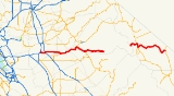
State Route 120 in northern California
, runs between the Central Valley near Manteca
, through Yosemite National Park
, and ends at U.S. Route 6 in Mono County
.
 This route is part of the California Freeway and Expressway System
and is eligible for the State Scenic Highway System
. However, it is not officially designated by Caltrans as a scenic highway.
 SR 120 begins as a freeway intersecting Interstate 5 to extend Interstate 205
through Manteca
. In east Manteca the freeway ends at SR 99
and becomes a highway which continues to head east through Escalon
, Oakdale
and other various small towns. East of Oakdale there are no highly populated areas for 90 miles (144 km) as it heads into the foothills of the Sierra Nevada and into Yosemite National Park
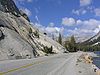
. After leaving Crane Flat within Yosemite, it is known as Tioga Pass Road, and it retains that name as it travels through Tuolumne Meadows
and over Tioga Pass
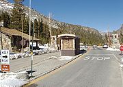
on its 59 miles (95 km) journey to its intersection with U.S. Route 395, at Lee Vining
. After a jog to the south along US 395, it continues east as the Mono Mills Road, skirting the south end of Mono Lake
and providing access to the Mono Lake South Tufa
as well as the historical site of Mono Mills
before cresting Sagehen Summit and ending with the intersection of U.S. Route 6
at Benton
. Both the portions through Yosemite National Park and the stretch south of Mono Lake are subject to winter closure. Usually the highway is open through Tioga Pass by the Memorial Day weekend at the end of May, and typically closes for the winter sometime in November.
through which it passes in the Sierra foothills. It was a pack trail from Stockton
which became popular with prospectors about 1849. By 1874 it was a wagon road which extended to the Yosemite Valley
.
In 1921, the California State Assembly
authorized San Joaquin County to transfer the county road connecting Manteca
with then-Route 5 (now I-5) at Mossdale to the state. It was numbered Route 66, as was a 1933 extension from Manteca east to Route 13 in Oakdale
. Also in 1933, Route 40 was extended east from Mono Lake to Route 76 (US 6) at Benton
. The route from Manteca to Benton was marked as Sign Route 120 in 1934, and was soon extended west to Mossdale, replacing what had been part of U.S. Route 99W.
{| class=wikitable
!County
!Location
!Postmile
!Exit
!Destinations
!Notes
|-
|rowspan=12|San Joaquin
SJ R0.49-21.18
|
|R0.49
|1
|
|Westbound exit and eastbound entrance; signed as exits 1A (south) and 1B (north); former US 50
west
|-
|
|R1.33
|1C
|Yosemite Avenue
|Signed as exit 1 eastbound
|-
|rowspan=3|Manteca
|R3.32
|3
|Airport Way (CR J3) – Sharpe Depot
|
|-
|R4.31
|4
|Union Road
|
|-
|R5.31
|5
|South Main Street
|
|-
|
|bgcolor=#ddffdd|T6.87
5.82Indicates that the postmile represents the distance along SR 99
rather than SR 120.
|bgcolor=#ddffdd|6
|bgcolor=#ddffdd|
|bgcolor=#ddffdd|West end of SR 99 overlap
|-
|rowspan=2|Manteca
|colspan=4 align=center|East end of freeway on SR 99
|-bgcolor=#ddffdd
|6.65
6.20
|
|, Central Manteca
|Interchange; east end of SR 99 overlap
|-
|
|8.84
|
|
|
|-
|
|11.64
|
|French Camp Road
|
|-
|rowspan=2|Escalon
|bgcolor=#ddffdd|
|bgcolor=#ddffdd|
|bgcolor=#ddffdd|
|bgcolor=#ddffdd|West end of CR J7 overlap
|-bgcolor=#ddffdd
|R16.92
|
|
|East end of CR J7 overlap
|-
|rowspan=3|Stanislaus
STA 0.00-T18.17
|
|bgcolor=#ddffdd|3.16
|bgcolor=#ddffdd|
|bgcolor=#ddffdd|
|bgcolor=#ddffdd|West end of CR J9 overlap
|-
|
|bgcolor=#ddffdd|
|bgcolor=#ddffdd|
|bgcolor=#ddffdd|
|bgcolor=#ddffdd|West end of CR J14 overlap
|-
|Oakdale
|bgcolor=#ddffdd|5.12
|bgcolor=#ddffdd|
|bgcolor=#ddffdd|
|bgcolor=#ddffdd|West end of SR 108 overlap; east end of CR J9 / CR J14 overlap
|-
|rowspan=8|Tuolumne
TUO R0.00-R41.52
|
|8.19
|
|
|
|-
|
|
|
|
|
|-
|
|bgcolor=#ddffdd|12.08
|bgcolor=#ddffdd|
|bgcolor=#ddffdd|
|bgcolor=#ddffdd|East end of SR 108 overlap
|-
|Chinese Camp
|bgcolor=#ddffdd|15.52
|bgcolor=#ddffdd|
|bgcolor=#ddffdd|
|bgcolor=#ddffdd|West end of SR 49 overlap
|-
|
|bgcolor=#ddffdd|R23.90
|bgcolor=#ddffdd|
|bgcolor=#ddffdd|
|bgcolor=#ddffdd|East end of SR 49 overlap
|-
|Groveland
|
|
|Ferretti Road – Pine Mountain Lake
|
|-
|Buck Meadows
|R39.46
|
|
|
|-
|colspan=5 align=center|West end of state maintenance at Yosemite National Park
west boundary
|-
|Mariposa
MPA R41.52-43.75
|Crane Flat Campground
|
|
|
|SR 120 subject to winter closure from Crane Flat to Lee Vining
|-
|rowspan=2|Tuolumne
TUO 43.75-R56.15
|colspan=5 align=center|No junctions
|-
|rowspan=2 colspan=5 align=center|East end of state maintenance at Yosemite National Park
east boundary
|-
|rowspan=5|Mono
MNO R0.00-58.99
|-
|Lee Vining
|bgcolor=#ddffdd|R12.06
50.74Indicates that the postmile represents the distance along US 395
rather than SR 120.
|bgcolor=#ddffdd|
|bgcolor=#ddffdd|, Reno
|bgcolor=#ddffdd|West end of US 395 overlap
|-
|June Lake Loop North Junction
|46.40
|
|
|SR 158 subject to winter closure from North Junction to Silver Lake
|-
|Mono Mills Junction
|bgcolor=#ddffdd nowrap|45.96
13.37
|bgcolor=#ddffdd|
|bgcolor=#ddffdd|
|bgcolor=#ddffdd|East end of US 395 overlap; SR 120 subject to winter closure from Mono Mills to Benton Crossing Road
|-
|Benton
|58.99
|
| – Tonopah
, Bishop
|
California
California is a state located on the West Coast of the United States. It is by far the most populous U.S. state, and the third-largest by land area...
, runs between the Central Valley near Manteca
Manteca, California
Manteca is a city in , USA. As of the 2010 census, the city's population was 67,096.- History :Manteca is a city in the Central Valley of California, 76 miles east of San Francisco. It was founded in 1861 by Joshua Cowell. Cowell claimed around and built houses on what is now the corner of Main...
, through Yosemite National Park
Yosemite National Park
Yosemite National Park is a United States National Park spanning eastern portions of Tuolumne, Mariposa and Madera counties in east central California, United States. The park covers an area of and reaches across the western slopes of the Sierra Nevada mountain chain...
, and ends at U.S. Route 6 in Mono County
Mono County, California
Mono County is a county located in the east central portion of the U.S. state of California, to the east of the Sierra Nevada between Yosemite National Park and Nevada. As of the 2010 census, the population was 14,202, up from 12,853 at the 2000 census...
.
Route description
California Freeway and Expressway System
The California Freeway and Expressway System is a system of existing or planned freeways and expressways in the U.S. state of California. It is defined by the Streets and Highways Code.-List of roads in the system:*State Route 1 *State Route 2...
and is eligible for the State Scenic Highway System
State Scenic Highway System (California)
The State Scenic Highway System is a list of highways, mainly state highways, that have been designated by the California Department of Transportation as scenic highways. The California State Legislature, primarily through Section 263 of the Streets and Highways Code, makes highways eligible for...
. However, it is not officially designated by Caltrans as a scenic highway.
Interstate 205 (California)
Interstate 205 is a short Interstate Highway that connects Interstate 5 with Interstate 580 in the San Joaquin Valley of California. Along with those highways, I-205 forms the north side of a triangle around the city of Tracy...
through Manteca
Manteca, California
Manteca is a city in , USA. As of the 2010 census, the city's population was 67,096.- History :Manteca is a city in the Central Valley of California, 76 miles east of San Francisco. It was founded in 1861 by Joshua Cowell. Cowell claimed around and built houses on what is now the corner of Main...
. In east Manteca the freeway ends at SR 99
California State Route 99
California State Route 99 , commonly known as Highway 99 or, simply, as 99 , is a north–south state highway in the U.S. state of California, stretching almost the entire length of the Central Valley...
and becomes a highway which continues to head east through Escalon
Escalon, California
Escalon is a city in San Joaquin County, California, United States. The population was 7,132 at the 2010 census, up from 5,963 at the 2000 census.-Geography:...
, Oakdale
Oakdale, California
Oakdale is a city in Stanislaus County, California, United States. It is part of the Modesto Metropolitan Statistical Area. The city was founded in 1871 when the Stockton & Visalia Railroad met the Copperopolis Railroad...
and other various small towns. East of Oakdale there are no highly populated areas for 90 miles (144 km) as it heads into the foothills of the Sierra Nevada and into Yosemite National Park
Yosemite National Park
Yosemite National Park is a United States National Park spanning eastern portions of Tuolumne, Mariposa and Madera counties in east central California, United States. The park covers an area of and reaches across the western slopes of the Sierra Nevada mountain chain...
. After leaving Crane Flat within Yosemite, it is known as Tioga Pass Road, and it retains that name as it travels through Tuolumne Meadows
Tuolumne Meadows
Tuolumne Meadows is a gentle, dome-studded sub-alpine meadowy section of the Tuolumne River, in the eastern section of Yosemite National Park. Its approximate location is . Its approximate elevation is 8619 feet .-Natural History:...
and over Tioga Pass
Tioga Pass
Tioga Pass is a mountain pass in the Sierra Nevada mountains of California. State Route 120 runs through it, and serves as the eastern entry point for Yosemite National Park. It is the highest highway pass in California and in the Sierra Nevada. Mount Dana is to the east of the pass...
on its 59 miles (95 km) journey to its intersection with U.S. Route 395, at Lee Vining
Lee Vining, California
Lee Vining is a census-designated place in Mono County, California, United States. It is located south-southeast of Bridgeport, at an elevation of 6781 feet . Lee Vining is located on the southwest shore of Mono Lake. The population was 222 as of the 2010 census, down from 250 reported as of 2000...
. After a jog to the south along US 395, it continues east as the Mono Mills Road, skirting the south end of Mono Lake
Mono Lake
Mono Lake is a large, shallow saline lake in Mono County, California, formed at least 760,000 years ago as a terminal lake in a basin that has no outlet to the ocean...
and providing access to the Mono Lake South Tufa
Mono Lake Tufa State Reserve
The Mono Lake Tufa State Reserve is located near Yosemite National Park within Mono County, in eastern California. It was established in 1981 by the California State Legislature, to preserve the natural limestone "tufa tower" formations at Mono Lake.-Access:...
as well as the historical site of Mono Mills
Mono Mills, California
Mono Mills is a ghost town in Mono County, California. It is located east-southeast of Lee Vining, at an elevation of 7356 feet . Mono Mills has nearly vanished, its site is along California State Route 120, east from the junction with U.S. Route 395.Mono Mills started as a lumber camp that...
before cresting Sagehen Summit and ending with the intersection of U.S. Route 6
U.S. Route 6 in California
U.S. Route 6, or US 6, is a transcontinental highway from the U.S. state of California to Massachusetts. In California, the highway lies in the eastern portion of the state from Bishop in the Owens Valley north to the Nevada state line in Esmeralda County...
at Benton
Benton, California
Benton is a census-designated place in Mono County, California, United States. It is located 3 miles east-northeast of the community of Benton Hot Springs and north of the community of Bishop, at an elevation of 5387 feet...
. Both the portions through Yosemite National Park and the stretch south of Mono Lake are subject to winter closure. Usually the highway is open through Tioga Pass by the Memorial Day weekend at the end of May, and typically closes for the winter sometime in November.
History
During the Gold Rush, SR 120 was originally known as Big Oak Flat Road, after the village of Big Oak FlatGroveland-Big Oak Flat, California
Groveland-Big Oak Flat is a former census-designated place in Tuolumne County, California, United States. The population was 3,388 at the 2000 census...
through which it passes in the Sierra foothills. It was a pack trail from Stockton
Stockton, California
Stockton, California, the seat of San Joaquin County, is the fourth-largest city in the Central Valley of the U.S. state of California. With a population of 291,707 at the 2010 census, Stockton ranks as this state's 13th largest city...
which became popular with prospectors about 1849. By 1874 it was a wagon road which extended to the Yosemite Valley
Yosemite Valley
Yosemite Valley is a glacial valley in Yosemite National Park in the western Sierra Nevada mountains of California, carved out by the Merced River. The valley is about long and up to a mile deep, surrounded by high granite summits such as Half Dome and El Capitan, and densely forested with pines...
.
In 1921, the California State Assembly
California State Assembly
The California State Assembly is the lower house of the California State Legislature. There are 80 members in the Assembly, representing an approximately equal number of constituents, with each district having a population of at least 420,000...
authorized San Joaquin County to transfer the county road connecting Manteca
Manteca, California
Manteca is a city in , USA. As of the 2010 census, the city's population was 67,096.- History :Manteca is a city in the Central Valley of California, 76 miles east of San Francisco. It was founded in 1861 by Joshua Cowell. Cowell claimed around and built houses on what is now the corner of Main...
with then-Route 5 (now I-5) at Mossdale to the state. It was numbered Route 66, as was a 1933 extension from Manteca east to Route 13 in Oakdale
Oakdale, California
Oakdale is a city in Stanislaus County, California, United States. It is part of the Modesto Metropolitan Statistical Area. The city was founded in 1871 when the Stockton & Visalia Railroad met the Copperopolis Railroad...
. Also in 1933, Route 40 was extended east from Mono Lake to Route 76 (US 6) at Benton
Benton, California
Benton is a census-designated place in Mono County, California, United States. It is located 3 miles east-northeast of the community of Benton Hot Springs and north of the community of Bishop, at an elevation of 5387 feet...
. The route from Manteca to Benton was marked as Sign Route 120 in 1934, and was soon extended west to Mossdale, replacing what had been part of U.S. Route 99W.
Major intersections
- Note: Except where prefixed with a letter, postmiles were measured in 1964, based on the alignment as it existed at that time, and do not necessarily reflect current mileage. The numbers reset at some county lines; the start and end postmiles in each county are given in the county column.
{| class=wikitable
!County
!Location
!Postmile
!Exit
Exit number
An exit number is a number assigned to a road junction, usually an exit from a freeway. It is usually marked on the same sign as the destinations of the exit, as well as a sign in the gore....
!Destinations
!Notes
|-
|rowspan=12|San Joaquin
San Joaquin County, California
San Joaquin County is a county located in Central Valley of the U.S. state of California, just east of the San Francisco Bay Area. As of the 2010 census, the population was 685,306. The county seat is Stockton.-History:...
SJ R0.49-21.18
|
|R0.49
|1
|
|Westbound exit and eastbound entrance; signed as exits 1A (south) and 1B (north); former US 50
U.S. Route 50 in California
In the U.S. state of California, U.S. Route 50 runs east from I-80 in West Sacramento to the Nevada state line in South Lake Tahoe. Portions within Sacramento are known as the Capital City Freeway and El Dorado Freeway...
west
|-
|
|R1.33
|1C
|Yosemite Avenue
|Signed as exit 1 eastbound
|-
|rowspan=3|Manteca
Manteca, California
Manteca is a city in , USA. As of the 2010 census, the city's population was 67,096.- History :Manteca is a city in the Central Valley of California, 76 miles east of San Francisco. It was founded in 1861 by Joshua Cowell. Cowell claimed around and built houses on what is now the corner of Main...
|R3.32
|3
|Airport Way (CR J3) – Sharpe Depot
|
|-
|R4.31
|4
|Union Road
|
|-
|R5.31
|5
|South Main Street
|
|-
|
|bgcolor=#ddffdd|T6.87
5.82Indicates that the postmile represents the distance along SR 99
California State Route 99
California State Route 99 , commonly known as Highway 99 or, simply, as 99 , is a north–south state highway in the U.S. state of California, stretching almost the entire length of the Central Valley...
rather than SR 120.
|bgcolor=#ddffdd|6
|bgcolor=#ddffdd|
|bgcolor=#ddffdd|West end of SR 99 overlap
|-
|rowspan=2|Manteca
Manteca, California
Manteca is a city in , USA. As of the 2010 census, the city's population was 67,096.- History :Manteca is a city in the Central Valley of California, 76 miles east of San Francisco. It was founded in 1861 by Joshua Cowell. Cowell claimed around and built houses on what is now the corner of Main...
|colspan=4 align=center|East end of freeway on SR 99
|-bgcolor=#ddffdd
|6.65
6.20
|
|, Central Manteca
Manteca, California
Manteca is a city in , USA. As of the 2010 census, the city's population was 67,096.- History :Manteca is a city in the Central Valley of California, 76 miles east of San Francisco. It was founded in 1861 by Joshua Cowell. Cowell claimed around and built houses on what is now the corner of Main...
|Interchange; east end of SR 99 overlap
|-
|
|8.84
|
|
|
|-
|
|11.64
|
|French Camp Road
|
|-
|rowspan=2|Escalon
Escalon, California
Escalon is a city in San Joaquin County, California, United States. The population was 7,132 at the 2010 census, up from 5,963 at the 2000 census.-Geography:...
|bgcolor=#ddffdd|
|bgcolor=#ddffdd|
|bgcolor=#ddffdd|
|bgcolor=#ddffdd|West end of CR J7 overlap
|-bgcolor=#ddffdd
|R16.92
|
|
|East end of CR J7 overlap
|-
|rowspan=3|Stanislaus
Stanislaus County, California
Stanislaus County is a county located in the Central Valley of the U.S. state of California. As the price of housing has increased in the San Francisco Bay Area, many people who work in the southern reaches of the Bay Area have opted for the longer commute and moved to Stanislaus County for the...
STA 0.00-T18.17
|
|bgcolor=#ddffdd|3.16
|bgcolor=#ddffdd|
|bgcolor=#ddffdd|
|bgcolor=#ddffdd|West end of CR J9 overlap
|-
|
|bgcolor=#ddffdd|
|bgcolor=#ddffdd|
|bgcolor=#ddffdd|
|bgcolor=#ddffdd|West end of CR J14 overlap
|-
|Oakdale
Oakdale, California
Oakdale is a city in Stanislaus County, California, United States. It is part of the Modesto Metropolitan Statistical Area. The city was founded in 1871 when the Stockton & Visalia Railroad met the Copperopolis Railroad...
|bgcolor=#ddffdd|5.12
|bgcolor=#ddffdd|
|bgcolor=#ddffdd|
|bgcolor=#ddffdd|West end of SR 108 overlap; east end of CR J9 / CR J14 overlap
|-
|rowspan=8|Tuolumne
Tuolumne County, California
Tuolumne County is a county in the Sierra Nevada of the U.S. state of California. The northern half of Yosemite National Park is located in the eastern part of the county. As of the 2010 census, the population was 55,365, up from 54,501 at the 2000 census...
TUO R0.00-R41.52
|
|8.19
|
|
|
|-
|
|
|
|
|
|-
|
|bgcolor=#ddffdd|12.08
|bgcolor=#ddffdd|
|bgcolor=#ddffdd|
|bgcolor=#ddffdd|East end of SR 108 overlap
|-
|Chinese Camp
Chinese Camp, California
Chinese Camp is a census-designated place in Tuolumne County, California, United States. The population was 126 at the 2010 census, down from 146 at the 2000 census. It lies in the grassy foothills of the Sierra Nevada near the southern end of California's Gold Country.-History:Chinese Camp is the...
|bgcolor=#ddffdd|15.52
|bgcolor=#ddffdd|
|bgcolor=#ddffdd|
|bgcolor=#ddffdd|West end of SR 49 overlap
|-
|
|bgcolor=#ddffdd|R23.90
|bgcolor=#ddffdd|
|bgcolor=#ddffdd|
|bgcolor=#ddffdd|East end of SR 49 overlap
|-
|Groveland
Groveland, California
Groveland is a census-designated place in Tuolumne County, California. Groveland sits at an elevation of . The 2010 United States census reported Groveland's population was 601....
|
|
|Ferretti Road – Pine Mountain Lake
Pine Mountain Lake, California
Pine Mountain Lake is a private gated community and a census-designated place in Tuolumne County, California. It is located eight tenths of a mile to the north and east of Groveland. Pine Mountain Lake sits at an elevation of . The 2010 United States census reported Pine Mountain Lake's...
|
|-
|Buck Meadows
Buck Meadows, California
Buck Meadows is a census-designated place in Mariposa County, California. It is located east-northeast of Smith Peak, at an elevation of 3015 feet . The population was 31 at the 2010 census....
|R39.46
|
|
|
|-
|colspan=5 align=center|West end of state maintenance at Yosemite National Park
Yosemite National Park
Yosemite National Park is a United States National Park spanning eastern portions of Tuolumne, Mariposa and Madera counties in east central California, United States. The park covers an area of and reaches across the western slopes of the Sierra Nevada mountain chain...
west boundary
|-
|Mariposa
Mariposa County, California
Mariposa County is a county in the U.S. state of California, located in the western foothills of the Sierra Nevada mountains. It lies north of Fresno, east of Merced, and southeast of Stockton. As of the 2010 census, the population was 18,251 up from 17,130 at the 2000 census...
MPA R41.52-43.75
|Crane Flat Campground
|
|
|
|SR 120 subject to winter closure from Crane Flat to Lee Vining
|-
|rowspan=2|Tuolumne
Tuolumne County, California
Tuolumne County is a county in the Sierra Nevada of the U.S. state of California. The northern half of Yosemite National Park is located in the eastern part of the county. As of the 2010 census, the population was 55,365, up from 54,501 at the 2000 census...
TUO 43.75-R56.15
|colspan=5 align=center|No junctions
|-
|rowspan=2 colspan=5 align=center|East end of state maintenance at Yosemite National Park
Yosemite National Park
Yosemite National Park is a United States National Park spanning eastern portions of Tuolumne, Mariposa and Madera counties in east central California, United States. The park covers an area of and reaches across the western slopes of the Sierra Nevada mountain chain...
east boundary
|-
|rowspan=5|Mono
Mono County, California
Mono County is a county located in the east central portion of the U.S. state of California, to the east of the Sierra Nevada between Yosemite National Park and Nevada. As of the 2010 census, the population was 14,202, up from 12,853 at the 2000 census...
MNO R0.00-58.99
|-
|Lee Vining
Lee Vining, California
Lee Vining is a census-designated place in Mono County, California, United States. It is located south-southeast of Bridgeport, at an elevation of 6781 feet . Lee Vining is located on the southwest shore of Mono Lake. The population was 222 as of the 2010 census, down from 250 reported as of 2000...
|bgcolor=#ddffdd|R12.06
50.74Indicates that the postmile represents the distance along US 395
U.S. Route 395 in California
In the U.S. state of California, U.S. Route 395 is a route which traverses from Interstate 15 near the southern city limits of Hesperia, north to the Oregon state line in Modoc County near Goose Lake...
rather than SR 120.
|bgcolor=#ddffdd|
|bgcolor=#ddffdd|, Reno
Reno, Nevada
Reno is the county seat of Washoe County, Nevada, United States. The city has a population of about 220,500 and is the most populous Nevada city outside of the Las Vegas metropolitan area...
|bgcolor=#ddffdd|West end of US 395 overlap
|-
|June Lake Loop North Junction
June Lake Loop North Junction, California
June Lake Loop North Junction is where the north end of the June Lake Loop Road June Lake Loop North Junction (also known as North June Lake Junction or North Junction June Lake Loop) is where the north end of the June Lake Loop Road June Lake Loop North Junction (also known as North June Lake...
|46.40
|
|
|SR 158 subject to winter closure from North Junction to Silver Lake
|-
|Mono Mills Junction
Mono Mills Junction, California
Mono Mills Junction is a location within the Mono Basin in central Mono County where the Mono Mills Road California State Route 120, proceeds eastward from U.S. Route 395...
|bgcolor=#ddffdd nowrap|45.96
13.37
|bgcolor=#ddffdd|
|bgcolor=#ddffdd|
|bgcolor=#ddffdd|East end of US 395 overlap; SR 120 subject to winter closure from Mono Mills to Benton Crossing Road
|-
|Benton
Benton, California
Benton is a census-designated place in Mono County, California, United States. It is located 3 miles east-northeast of the community of Benton Hot Springs and north of the community of Bishop, at an elevation of 5387 feet...
|58.99
|
| – Tonopah
Tonopah, Nevada
Tonopah is a census-designated place located in and the county seat of Nye County, Nevada. It is located at the junction of U.S. Routes 6 and 95 approximately mid-way between Las Vegas and Reno....
, Bishop
Bishop, California
Bishop is a city in Inyo County, California, United States. Though Bishop is the only city and the largest populated place in Inyo County, the county seat is Independence. Bishop is located near the northern end of the Owens Valley, at an elevation of 4147 feet . The population was 3,879 at the...
|