
Sonoma County, California
Overview
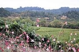
Sonoma County, located on the northern coast of the U.S. state
of California
, is the largest (in area) and northernmost of the nine San Francisco Bay Area
counties
. Its population at the 2010 census was 483,878. Its largest city and county seat
is Santa Rosa
.
Sonoma is the southwestern county of California's Wine Country region, which also includes Napa
, Mendocino
, and Lake
counties. It has 13 approved American Viticultural Area
s and over 250 wineries. In 2002, Sonoma County ranked as the 32nd county in the United States in agricultural production.
U.S. state
A U.S. state is any one of the 50 federated states of the United States of America that share sovereignty with the federal government. Because of this shared sovereignty, an American is a citizen both of the federal entity and of his or her state of domicile. Four states use the official title of...
of California
California
California is a state located on the West Coast of the United States. It is by far the most populous U.S. state, and the third-largest by land area...
, is the largest (in area) and northernmost of the nine San Francisco Bay Area
San Francisco Bay Area
The San Francisco Bay Area, commonly known as the Bay Area, is a populated region that surrounds the San Francisco and San Pablo estuaries in Northern California. The region encompasses metropolitan areas of San Francisco, Oakland, and San Jose, along with smaller urban and rural areas...
counties
County (United States)
In the United States, a county is a geographic subdivision of a state , usually assigned some governmental authority. The term "county" is used in 48 of the 50 states; Louisiana is divided into parishes and Alaska into boroughs. Parishes and boroughs are called "county-equivalents" by the U.S...
. Its population at the 2010 census was 483,878. Its largest city and county seat
County seat
A county seat is an administrative center, or seat of government, for a county or civil parish. The term is primarily used in the United States....
is Santa Rosa
Santa Rosa, California
Santa Rosa is the county seat of Sonoma County, California, United States. The 2010 census reported a population of 167,815. Santa Rosa is the largest city in California's Wine Country and fifth largest city in the San Francisco Bay Area, after San Jose, San Francisco, Oakland, and Fremont and 26th...
.
Sonoma is the southwestern county of California's Wine Country region, which also includes Napa
Napa County, California
Napa County is a county located north of the San Francisco Bay Area in the U.S. state of California. It is coterminous with the Napa, California, Metropolitan Statistical Area. As of 2010 the population is 136,484. The county seat is Napa....
, Mendocino
Mendocino County, California
Mendocino County is a county located on the north coast of the U.S. state of California, north of the greater San Francisco Bay Area and west of the Central Valley. As of the 2010 census, the population was 87,841, up from 86,265 at the 2000 census...
, and Lake
Lake County, California
Lake County is a county located in the north central portion of the U.S. state of California, north of the San Francisco Bay Area. It takes its name from Clear Lake, the dominant geographic feature in the county and the largest natural lake wholly within California...
counties. It has 13 approved American Viticultural Area
American Viticultural Area
An American Viticultural Area is a designated wine grape-growing region in the United States distinguishable by geographic features, with boundaries defined by the Alcohol and Tobacco Tax and Trade Bureau , United States Department of the Treasury....
s and over 250 wineries. In 2002, Sonoma County ranked as the 32nd county in the United States in agricultural production.
Discussions