
California State Route 44
Encyclopedia
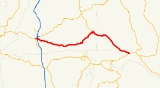
State Route 44 is a state highway
in the U.S. State
of California
that travels in an east–west direction from Redding
to Lassen Volcanic National Park
before ending at Route 36
west of Susanville
. This final portion, between the park and its terminus, is part of the Volcanic Legacy Scenic Byway
, a National Scenic Byway
.
and is eligible for the State Scenic Highway System
. However, it is not a scenic route as designated by Caltrans.
Route 44 starts on Tehama Street in Redding, at the intersection of Route 273
(Market Street), despite what it says in its legal definition. This is because in 1998, Route 299
's definition was changed. It previously ran on Tehama St. to I-5, but this portion was transferred to Route 44 in 1998 (44 had ended at I-5 at that time); however, the legislative definition has never changed, so it is unclear as to where Route 44 officially begins. Note also that the postmile markers have not been updated, so the Route 44–I-5 interchange is still marked as 0.00.
After a few blocks, it becomes a freeway as it crosses I-5 and changes back to a highway at the Redding city limits. Heading eastward, Route 44 passes through a number of small, rural communities (Palo Cedro
, Millville
, Shingletown
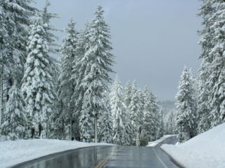
, to name a few) before it reaches the north-west entrance to Lassen National Park
. After this, the only community it passes through is Old Station
, which is also the only location for travel services until Susanville
.
From the Park entrance, Route 44 joins the Volcanic Legacy Scenic Byway
. Route 44 is part of a circular portion of the Scenic Byway, so at the junction with Route 89
, the Byway continues along both 89 to the north and on 44 to the east. When Route 44 reaches its terminus at Route 36
, the byway heads southwest to continue its circular path.
Between the Route 89 intersection and Route 36 is only one rest area, called Bogard.
{| class=wikitable
!County
!Location
!Postmile
!Exit
!Destinations
!Notes
|-
|rowspan=17|Shasta
SHA L0.00-71.39
|rowspan=10|Redding
|bgcolor=#ddffdd|L0.00
|bgcolor=#ddffdd|
|bgcolor=#ddffdd|
|bgcolor=#ddffdd|West end of SR 273 overlap
|-bgcolor=#ddffdd
|L0.17
|
|
|East end of SR 273 overlap
|-
|colspan=4 align=center|West end of freeway
|-
|L0.85
|1
|Park Marina Drive, Auditorium Drive
|
|-
|L1.81
R0.00
|2
|, Portland
|Signed as exits 2A (south) and 2B (north)
|-bgcolor=#ffdddd
|R0.13
|2C
|Hilltop Drive
|Eastbound exit and entrance
|-bgcolor=#ffdddd
|R0.38
|3A
|Dana Drive
|Westbound exit and entrance
|-
|R1.24
|3B
|Victor Avenue
|Signed as exit 3 eastbound
|-
|R2.13
|4
|Shasta View Drive
|
|-
|R3.63
|5
|Old Oregon Trail, Airport Road
|
|-
|colspan=5 align=center|East end of freeway
|-
|
|R7.00
|
|Deschutes Road
|Interchange
|-
|
|R10.77
|
|Millville Plains Road, Old Forty Four Drive – Millville
, Whitmore
|
|-
|
|R19.01
|
|
|
|-
|Shingletown
|R27.83
|
|Wilson Hill Road, Emigrant Trail – Manton
|
|-
|
|bgcolor=#ddffdd|R49.35
|bgcolor=#ddffdd|
|bgcolor=#ddffdd|
|bgcolor=#ddffdd|West end of SR 89 overlap
|-
|
|bgcolor=#ddffdd|62.69
|bgcolor=#ddffdd|
|bgcolor=#ddffdd| – Burney Falls
, Mount Shasta
|bgcolor=#ddffdd|East end of SR 89 overlap
|-
|rowspan=2|Lassen
LAS 0.00-37.25
|
|19.29
|
|
|
|-
|
|37.25
|
|
|
State highway
State highway, state road or state route can refer to one of three related concepts, two of them related to a state or provincial government in a country that is divided into states or provinces :#A...
in the U.S. State
U.S. state
A U.S. state is any one of the 50 federated states of the United States of America that share sovereignty with the federal government. Because of this shared sovereignty, an American is a citizen both of the federal entity and of his or her state of domicile. Four states use the official title of...
of California
California
California is a state located on the West Coast of the United States. It is by far the most populous U.S. state, and the third-largest by land area...
that travels in an east–west direction from Redding
Redding, California
Redding is a city in far-Northern California. It is the county seat of Shasta County, California, USA. With a population of 89,861, according to the 2010 Census...
to Lassen Volcanic National Park
Lassen Volcanic National Park
Lassen Volcanic National Park is a United States National Park in northeastern California. The dominant feature of the park is Lassen Peak; the largest plug dome volcano in the world and the southern-most volcano in the Cascade Range...
before ending at Route 36
California State Route 36
State Route 36 is an east–west state highway in the U.S. state of California that is routed from U.S. Route 101 in Humboldt County to U.S. Route 395 just east of Susanville in Lassen County. The portion of SR 36 travelling past Lassen Volcanic National Park and Lake Almanor is part of the...
west of Susanville
Susanville, California
Susanville is the county seat of Lassen County, California, United States. Susanville is located on the Susan River in the south-central part of the county, at an elevation of 4186 feet . The population was 17,974 at the 2010 census, up from 13,541 at the 2000 census...
. This final portion, between the park and its terminus, is part of the Volcanic Legacy Scenic Byway
Volcanic Legacy Scenic Byway
The Volcanic Legacy Scenic Byway is an All-American Road in the U.S. states of California and Oregon. It is roughly 500 miles long and travels through the Cascade Range past numerous volcanoes. It is composed of two separate National Scenic Byways, the Volcanic Legacy Scenic Byway - Oregon and...
, a National Scenic Byway
National Scenic Byway
A National Scenic Byway is a road recognized by the United States Department of Transportation for its archeological, cultural, historic, natural, recreational, and/or scenic qualities. The program was established by Congress in 1991 to preserve and protect the nation's scenic but often...
.
Route description
This route is part of the California Freeway and Expressway SystemCalifornia Freeway and Expressway System
The California Freeway and Expressway System is a system of existing or planned freeways and expressways in the U.S. state of California. It is defined by the Streets and Highways Code.-List of roads in the system:*State Route 1 *State Route 2...
and is eligible for the State Scenic Highway System
State Scenic Highway System (California)
The State Scenic Highway System is a list of highways, mainly state highways, that have been designated by the California Department of Transportation as scenic highways. The California State Legislature, primarily through Section 263 of the Streets and Highways Code, makes highways eligible for...
. However, it is not a scenic route as designated by Caltrans.
Route 44 starts on Tehama Street in Redding, at the intersection of Route 273
California State Route 273
State Route 273 is a state highway in Shasta County, California, USA. The route takes a more direct approach to the cities of Anderson and Redding, passing through their downtown districts. Interstate 5 is a bypass of this route, as it connects both ends. This route was part of former U.S. Route...
(Market Street), despite what it says in its legal definition. This is because in 1998, Route 299
California State Route 299
State Route 299 is a state highway in the U.S. state of California that runs across the northern part of the state. It runs from Arcata on the Pacific Ocean to the border with Nevada. Between Arcata and Redding, Route 299 junctions with State Route 96 and is briefly co-signed with State Route 3. In...
's definition was changed. It previously ran on Tehama St. to I-5, but this portion was transferred to Route 44 in 1998 (44 had ended at I-5 at that time); however, the legislative definition has never changed, so it is unclear as to where Route 44 officially begins. Note also that the postmile markers have not been updated, so the Route 44–I-5 interchange is still marked as 0.00.
After a few blocks, it becomes a freeway as it crosses I-5 and changes back to a highway at the Redding city limits. Heading eastward, Route 44 passes through a number of small, rural communities (Palo Cedro
Palo Cedro, California
Palo Cedro is a census-designated place in Shasta County, California, United States. The population was 1,269 at the 2010 census, up from 1,247 at the 2000 census. It is east of Redding, California. The communities of Bella Vista , Millville , Shingletown , Oak Run , Whitmore , and Round...
, Millville
Millville, California
Millville is a census-designated place in Shasta County, California, United States. The population was 727 at the 2010 census, up from 610 at the 2000 census.-Geography:Millville is located at ....
, Shingletown
Shingletown, California
Shingletown is a census-designated place in Shasta County, California, United States. The population was 2,283 at the 2010 census, up from 2,222 at the 2000 census....
, to name a few) before it reaches the north-west entrance to Lassen National Park
Lassen Volcanic National Park
Lassen Volcanic National Park is a United States National Park in northeastern California. The dominant feature of the park is Lassen Peak; the largest plug dome volcano in the world and the southern-most volcano in the Cascade Range...
. After this, the only community it passes through is Old Station
Old Station, California
Old Station is a census-designated place in Shasta County, California. It is located 13 miles north of Lassen Volcanic National Park, directly in between Redding and Susanville. The ZIP code in Old Station is 96071 and the area code 530. Old Station sits at an elevation of...
, which is also the only location for travel services until Susanville
Susanville, California
Susanville is the county seat of Lassen County, California, United States. Susanville is located on the Susan River in the south-central part of the county, at an elevation of 4186 feet . The population was 17,974 at the 2010 census, up from 13,541 at the 2000 census...
.
From the Park entrance, Route 44 joins the Volcanic Legacy Scenic Byway
Volcanic Legacy Scenic Byway
The Volcanic Legacy Scenic Byway is an All-American Road in the U.S. states of California and Oregon. It is roughly 500 miles long and travels through the Cascade Range past numerous volcanoes. It is composed of two separate National Scenic Byways, the Volcanic Legacy Scenic Byway - Oregon and...
. Route 44 is part of a circular portion of the Scenic Byway, so at the junction with Route 89
California State Route 89
State Route 89 is a California State Highway that travels in the north–south direction, and is the major thoroughfare for many mountain communities. It starts from U.S. Route 395 near Topaz Lake, winding its way up to the Monitor Pass, down to the Carson River, and up again over the Luther...
, the Byway continues along both 89 to the north and on 44 to the east. When Route 44 reaches its terminus at Route 36
California State Route 36
State Route 36 is an east–west state highway in the U.S. state of California that is routed from U.S. Route 101 in Humboldt County to U.S. Route 395 just east of Susanville in Lassen County. The portion of SR 36 travelling past Lassen Volcanic National Park and Lake Almanor is part of the...
, the byway heads southwest to continue its circular path.
Between the Route 89 intersection and Route 36 is only one rest area, called Bogard.
Major intersections
- Note: Except where prefixed with a letter, postmiles were measured in 1964, based on the alignment as it existed at that time, and do not necessarily reflect current mileage. The numbers reset at county lines; the start and end postmiles in each county are given in the county column.
{| class=wikitable
!County
!Location
!Postmile
!Exit
Exit number
An exit number is a number assigned to a road junction, usually an exit from a freeway. It is usually marked on the same sign as the destinations of the exit, as well as a sign in the gore....
!Destinations
!Notes
|-
|rowspan=17|Shasta
Shasta County, California
Shasta County is a county located in the northern portion of the U.S. state of California. The county occupies the northern reaches of the Sacramento Valley, with portions extending into the southern reaches of the Cascade Range. As of the 2010 census, the population was 177,223, up from 163,256...
SHA L0.00-71.39
|rowspan=10|Redding
Redding, California
Redding is a city in far-Northern California. It is the county seat of Shasta County, California, USA. With a population of 89,861, according to the 2010 Census...
|bgcolor=#ddffdd|L0.00
|bgcolor=#ddffdd|
|bgcolor=#ddffdd|
|bgcolor=#ddffdd|West end of SR 273 overlap
|-bgcolor=#ddffdd
|L0.17
|
|
|East end of SR 273 overlap
|-
|colspan=4 align=center|West end of freeway
|-
|L0.85
|1
|Park Marina Drive, Auditorium Drive
|
|-
|L1.81
R0.00
|2
|, Portland
Portland, Oregon
Portland is a city located in the Pacific Northwest, near the confluence of the Willamette and Columbia rivers in the U.S. state of Oregon. As of the 2010 Census, it had a population of 583,776, making it the 29th most populous city in the United States...
|Signed as exits 2A (south) and 2B (north)
|-bgcolor=#ffdddd
|R0.13
|2C
|Hilltop Drive
|Eastbound exit and entrance
|-bgcolor=#ffdddd
|R0.38
|3A
|Dana Drive
|Westbound exit and entrance
|-
|R1.24
|3B
|Victor Avenue
|Signed as exit 3 eastbound
|-
|R2.13
|4
|Shasta View Drive
|
|-
|R3.63
|5
|Old Oregon Trail, Airport Road
|
|-
|colspan=5 align=center|East end of freeway
|-
|
|R7.00
|
|Deschutes Road
|Interchange
|-
|
|R10.77
|
|Millville Plains Road, Old Forty Four Drive – Millville
Millville, California
Millville is a census-designated place in Shasta County, California, United States. The population was 727 at the 2010 census, up from 610 at the 2000 census.-Geography:Millville is located at ....
, Whitmore
Whitmore, California
Whitmore is an unincorporated town of 166 people in the U.S. state of California. It is equidistantly north of Shingletown and east of Redding. Its zip code is 96096, and wired telephone numbers follow the pattern 530-472-xxxx, which is shared by the neighboring communities of Oak Run and Ingot...
|
|-
|
|R19.01
|
|
|
|-
|Shingletown
Shingletown, California
Shingletown is a census-designated place in Shasta County, California, United States. The population was 2,283 at the 2010 census, up from 2,222 at the 2000 census....
|R27.83
|
|Wilson Hill Road, Emigrant Trail – Manton
Manton, California
Manton is a census-designated place in Tehama County, California, United States. The population was 347 at the 2010 census, down from 372 at the 2000 census....
|
|-
|
|bgcolor=#ddffdd|R49.35
|bgcolor=#ddffdd|
|bgcolor=#ddffdd|
|bgcolor=#ddffdd|West end of SR 89 overlap
|-
|
|bgcolor=#ddffdd|62.69
|bgcolor=#ddffdd|
|bgcolor=#ddffdd| – Burney Falls
Burney Falls
Burney Falls is a waterfall on Burney Creek, in McArthur-Burney Falls Memorial State Park, Shasta County, California.The water comes from underground springs above and at the falls, which are 129 feet high, and provides an almost constant flow rate of 100 million US gallons per day , even during...
, Mount Shasta
Mount Shasta
Mount Shasta is located at the southern end of the Cascade Range in Siskiyou County, California and at is the second highest peak in the Cascades and the fifth highest in California...
|bgcolor=#ddffdd|East end of SR 89 overlap
|-
|rowspan=2|Lassen
Lassen County, California
Lassen County is a county located in the northeastern portion of the U.S. state of California. As of the 2010 census, the population was 34,895, up from 33,828 at the 2000 census...
LAS 0.00-37.25
|
|19.29
|
|
|
|-
|
|37.25
|
|
|