

U.S. Route 50 in California
Encyclopedia
In the U.S. state
of California
, U.S. Route 50
(US 50) runs east from I-80
in West Sacramento
to the Nevada
state line in South Lake Tahoe
. Portions within Sacramento are known as the Capital City Freeway and El Dorado Freeway. The western half of the highway, from I-80 through Sacramento
and Placerville
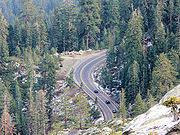
to the canyon of the South Fork American River at Riverton
, is a four-or-more-lane divided highway
, mostly built to freeway standards. The remainder, passing through the canyon, over the Sierra Nevada at Echo Summit
, and into the Lake Tahoe Basin, is a mainly two-lane road.
The US 50 corridor is a historic one, used by many 49er
s who came to California during the Gold Rush
as well as the Pony Express
. In 1895, part of the present-day route was designated as California's first state highway
, and it was later considered as a scenic alternate of the Lincoln Highway
. Much of US 50 was constructed during the initial construction of the California state highway system
. During the second half of the twentieth century, US 50 was gradually designated and converted into a modern highway.
by the state legislature. The highway east of SR 49
is eligible for the State Scenic Highway System
, and has been recognized as such except within the South Lake Tahoe
city limits.
US 50 begins in West Sacramento
, where I-80
leaves the West Sacramento Freeway onto a bypass of Sacramento
. The old route of I-80 through Sacramento is signed as Business 80 (Capital City Freeway), which overlaps US 50 on the West Sacramento Freeway to the split with SR 275
, then over the Sacramento River
on the Pioneer Memorial Bridge and across I-5
to SR 99
.

 There Business 80 splits to the north, SR 99 heads south, and US 50 continues east as the El Dorado Freeway. This freeway parallels Folsom Boulevard
and the American River
east-northeasterly through the suburb
of Rancho Cordova
to near Folsom
. There US 50 turns east, running cross-country through the foothills of the Sierra Nevada
via El Dorado Hills
, Cameron Park
, and Shingle Springs
to downtown Placerville
. The freeway temporarily ends, and US 50 has several at-grade intersection
s in Placerville, including SR 49
.
Leaving Placerville, the freeway restarts, only to end several miles later. The final section of freeway begins as a bypass of Camino
, and then heads east-northeast through Pollock Pines
to near the canyon of the South Fork American River. The four-lane cross section continues with intersections until the crossover bridge to the north side of the river at Riverton
. From Riverton to the crest of the Sierras, US 50 is a steadily rising mostly two-lane road, staying just north of the river except for a 1995 cutoff that crosses the river twice in quick succession west of Kyburz
, the boyhood home of ski racer Spider Sabich
.
Several hairpin turn
s take the highway up a grade east of Strawberry
, after which US 50 continues east alongside the river to its source at Echo Summit. Echo Summit is the highest elevation U.S. Route 50 reaches in California at 7377 feet (2,248.5 m). From Echo Summit down to the Lake Tahoe Basin, the roadway slowly descends the side of a steep hill; it then curves northeast and meets SR 89
, which heads south to Luther Pass
and overlaps US 50 northeast into the city of South Lake Tahoe
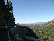
. Where US 50 and SR 89 split, at an intersection known as "The Y", the former turns east on the four-lane Lake Tahoe Boulevard, which it follows to and along the south shore of Lake Tahoe
, then it enters the state
of Nevada
.
into California were branches of the California Trail
. The first route near the present US 50 was the Carson Route, laid out in 1848 by an eastward Mormon
party
that wanted to avoid the Truckee Route and its deep crossings of the Truckee River
. The group left Pleasant Valley
, southeast of Placerville
, on July 3, following Iron Mountain Ridge up to the crest of the Sierra at Carson Pass
and then descending through Carson Canyon into the Carson Valley. Along the Humboldt River
in Nevada
, the Mormons
met Joseph B. Chiles
, who was leading a westward wagon train
to California, and told him of their new trail. Although this new Carson Route crossed two summits — Carson Pass over the crest of the Sierra and West Pass over the Carson Spur just to the west, these crossings were easier than Donner Pass
on the Truckee Route, and only three ford
s of the Carson River
were required. The route became the primary westward route into California at the start of the Gold Rush
. Through California, the general alignment of the Carson Route, in terms of today's highways, was State Route 88 over Carson Pass and Mormon Emigrant Trail and Sly Park Road to Pleasant Valley.
John Calhoun Johnson
of Placerville surveyed and cleared a shorter, lower (and thus less snow-covered) trail east from that town in 1852, completing the work by the summer. Rather than following the ridge to the Sierra's crest as the Mormons had, Johnson headed eastward to the South Fork American River, crossing to its north side near the present Pacific Ranger Station in order to follow Peavine Ridge around a rocky stretch of the river. Returning to the river between Kyburz
and Strawberry
, he then continued alongside it to the crest at Johnson Pass
, where a steep slope descended to Lake Tahoe
. Within Nevada, his route generally followed the lake to Glenbrook
, where it turned inland and crossed the Carson Range
over Spooner Summit into the Carson Valley near Carson City
. This trail, known as Johnson's Cut-off, generally followed the present US 50, with notable deviations only just east of Placerville (via Carson Road), over Peavine Ridge (roughly following Peavine Ridge Road, some trails, and Wrights Lake Road), just east of Strawberry (via Slippery Ford Road), over the crest of the Sierra (via Johnson Pass Road and Meyers Road), south of Lake Tahoe (via Pioneer Trail), east of Lake Tahoe (via Genoa Peak Road), and from Spooner Summit into the Carson Valley (via Kings Canyon Road). By 1854, Bartlett's Bridge had been built at the trail's westernmost crossing of the American River, allowing wagons to follow the cutoff; it was soon washed away by a freshet
on March 7, 1855, and replaced by Brockliss Bridge, several miles to the east. Due to an improvement of the road through Carson Canyon on the old Carson Route, most travelers ended up turning southeast from Johnson Pass over Luther Pass
(present SR 89
) to join the older route northeast of Carson Pass rather than following the cutoff along Lake Tahoe.
Johnson's Cut-off was the only trail that could be used year-round, but it still had problems, as it had been built without use of earth-moving equipment, and thus did not always take the optimal route. The state adopted a survey by Sherman Day
in September 1855, but failed to make use of it. Two years later, the counties of Yolo
, Sacramento
, and El Dorado
, all of which would be benefited by further improvements, began planning and carrying out work. The state legislature created a "Board of Wagon Commissioners" on March 8, 1858, and it completed the improvements by the end of that year. This new route had better grades than the old cutoff, deviating from it in several places: it followed the present Smith Flat Road rather than Carson Road east of Placerville, traversed Peavine Ridge much further down the slope, returning to the river west of Kyburz (roughly via the present White Meadows Road, Ice House Road, and Weber Mill Road to US 50 at Granite Springs Road), and crossed into Carson Valley via Luther Pass. By 1860, the immense traffic over the road and lack of maintenance had worsened it to the point that it could no longer be used by stagecoach
es.
To provide for better maintenance, improvements funded by toll
s were authorized. The first of these was built and operated by Kingsbury and McDonald, who improved the old Johnson's Cut-off between Johnson Pass and Stateline
, where they turned east over Daggett Pass (now SR 207) in Nevada, connecting Lake Tahoe to the Carson Valley via a shorter route than that over Luther Pass. Two other competing toll roads soon opened across the Carson Range: one built by Rufus Walton from Spooner Summit down Clear Creek to the valley (now part of US 50), and an 1863 improvement of the original Johnson's Cut-Off along the lake, across Spooner Summit, and through Kings Canyon to Carson City. West of Johnson Pass, the Slippery Ford Grade down to Strawberry was rebuilt by George W. Swan. The first toll-supported bypass of Peavine Ridge was built by Oglesby and opened in 1861, leaving the old road from Placerville at Pollock Pines
, following the ridgetops and slopes south of the South Fork American River, crossing the river east of White Hall
, and then following US 50 along the north bank to the 1858 county road west of Kyburz. Johnson began work on a lower-grade replacement on the north side of the river in 1864, but stopped when Pearson and McDonald opened a road over the present alignment of US 50, leaving the pre-1861 main road southwest of Brockliss Bridge and following US 50, across the river at Riverton
, to Oglesby's road east of White Hall. Toll collection ended in California in 1886, when El Dorado County bought the privately-improved sections and made them public roads.
West of Placerville, the wagon road headed south to Diamond Springs
, where it turned west along the original Carson Route over relatively gentle terrain to Sacramento
, generally following the present US 50 on parallel surface roads, such as Pleasant Valley Road and White Rock Road. The Pony Express
used this route from its beginning in April 1860 until July 1, when its western terminus became Folsom
on the Sacramento Valley Railroad. (The route was further cut back to Placerville, where messages were passed to the telegraph, from July 1861 to its discontinuance in October.) The Placerville and Sacramento Valley Railroad reached Latrobe
in 1864, Shingle Springs
(on the old Carson Route west of Placerville) in 1865, and was finally completed to Placerville in 1888. As the railroad extended east, the western terminus of the stage lines followed; the completion of the First Transcontinental Railroad
in 1869 took most of the traffic off the Placerville wagon road.
 At the dawn of the automobile
era, the state legislature authorized California's first state road on March 26, 1895 by creating the post of "Lake Tahoe Wagon Road Commissioner" to maintain the road from Newtown Road near Smith Flat (just east of Placerville) to Nevada. The county deed
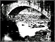
ed the 58-mile (93 km) road to the state on February 28, 1896. Funding was only enough for minimal improvements, including a new stone bridge
over the South Fork American River at Riverton in 1901. The Department of Engineering took over its maintenance in 1907, immediately completed a survey and posted granite
milestone
s that marked the distance from Placerville, and in 1910 started sprinkling the dirt road
with water in summer to keep down dust (as had been done in the 1860s). A 1915 law added the short distance from Smith Flat west to the east limits of Placerville to the state road.
With the passage of the first state highway bond issue in 1910, the Department of Engineering was directed to lay out and construct a system connecting all county seat
s. Placerville, seat of El Dorado County, was connected to Sacramento
by the 46.5-mile (74.8 km) Route 11, which followed Folsom Boulevard
from Sacramento to Folsom
, Bidwell Street and Placerville Road to White Rock, the old Carson Route to El Dorado
, and Forni Road and Placerville Drive to Placerville. Between El Dorado and Placerville, the state had two routes to choose from, including one via Diamond Springs
(present SR 49
), where it decided improving a cut would be too expensive. Instead, it chose the "O'Keefe grade" (Forni Road), following the old road for about 4 miles (6 km) and then building a cutoff (now part of Placerville Drive) to the Green Valley road. In 1917 the mileage that had been added by special laws, rather than as part of bond issues, was consolidated with the rest of the system, and Route 11 was extended east to the state line. (The route was extended farther, from Sacramento southwest to Antioch
via present SR 160
, in 1933.) The third bond issue, passed in 1919, included funds for the improvement of 10 miles (16 km) from Placerville east to Sportsman's Hall, by which time paving was complete west of Placerville.
 The Lincoln Highway
, one of the earliest marked highways across the country, split in two over the Sierra Nevada. The main route followed the present I-80 alignment over Donner Pass
, but an alternate "Pioneer Branch", designated as part of the initial routing in 1913, turned south at Reno, Nevada
to Carson City
and then crossed the Sierras via Johnson Pass and the Placerville route. Contrary to the Lincoln Highway Association's policy of marking the most direct route, this deviation was explained simply as "for those tourists desiring to see Lake Tahoe". However, it actually became shorter in 1921, when the Fallon Cut-off opened from Carson City directly east to the main route near Fallon
, bypassing Reno. The U.S. Highway system was created in 1926, and this route (along with the main Lincoln Highway east of the cutoff) became part of U.S. Route 50
. (The Donner Pass route was U.S. Route 40
, crossing Nevada on the Victory Highway
.) US 50 initially ended in Sacramento, where motorists could follow US 40 (Victory Highway) southwest to the San Francisco Bay Area
or turn south over US 99 to Stockton
and take US 48 (Lincoln Highway) west over Altamont Pass
. Originally, US 48 was a road connecting the San Francisco Bay
area with the San Joaquin Valley
, traveling from San Jose to near Modesto
, largely following the future routing of US 50, which replaced US 48. Its western terminus was located near the present location of the Interstate 238
/Interstate 880
interchange. It generally followed the route of current Interstate 580
to the Interstate 205
junction. From here, US 48 continued east on Interstate 205
, then followed Old Highway 50 (present I-205 Bus.) through Tracy, thence to Interstate 5
. It then followed Interstate 5
to SR 120
, where US 48 followed SR 120
to the old location of the SR 99
/SR 120
interchange (present day intersection of Main and Yosemite in Manteca), the location of its eastern terminus.
At this time, US 50 was improved but unpaved east of Placerville. As part of the state project to pave this portion, the old road was bypassed in several areas, completing the final two-lane alignment. These realignments included Broadway, bypassing Smith Flat Road, at Smith Flat (1932), a new route around Slippery Ford Grade east of Strawberry
(1931), and a new route through South Lake Tahoe
, leaving behind Pioneer Trail (1931). The crossing of the Sierra crest at Johnson Pass
was bypassed in 1940 by a better-quality route over Echo Summit
; the lower part of the current road east of the summit opened in 1947, bypassing Meyers Road. West of Placerville, several major two-lane relocations were built. A bypass (now Mother Lode Drive) around El Dorado
and the winding Forni Road was completed in 1938, and the improvement was extended west to Shingle Springs
in 1947. A short relocation north of White Rock, between Bidwell Street and Bass Lake Road, opened in 1940, and was extended west beyond Hazel Avenue, bypassing Folsom
, in 1949.
and replacing US 48 over Altamont Pass
to US 101E (Foothill Boulevard
at Castro Valley Boulevard) near Hayward
. It was extended over the new Bay Bridge at the time of its opening in 1936, replacing US 101E on Foothill Boulevard and the present MacArthur Boulevard to the Bay Bridge Distribution Structure in Oakland
. As the new MacArthur Freeway (now I-580) was constructed, US 50 was moved to it. This extension was officially eliminated in the 1964 renumbering, but it remained on maps and signs for several more years before being replaced I-80 over the Bay Bridge, I-580
over Altamont Pass, I-205
business route through Tracy
, I-5 to Stockton, SR 4 and SR 26
(Charter Way) through Stockton, and SR 99
to Sacramento.
was created in 1959, it included US 50 from Sacramento to Nevada. (The Oakland-Sacramento portion was also included, mostly as part of the Interstate Highway System
.) Two segments had already been upgraded to freeway or expressway
standards — an expressway through Placerville
, completed in 1955, and a freeway bypass of Camino
with an expressway continuing west to Five Mile Terrace
, completed in 1957. From Pollock Pines
east to the bridge at Riverton
, the road was widened to four lanes in about 1960. The next decade saw the improvement of every remaining two-lane section between Rancho Cordova
(near Sunrise Boulevard) and Riverton, with the final section, connecting Bass Lake Road and Shingle Springs
, opening in July 1970. The freeway was completed west to I-80 (now Business 80) and SR 99
in early 1973, bypassing the mostly four-lane Folsom Boulevard
. US 50 was extended west along former I-80 to the new I-80 bypass in 1981, when the old I-80 became Business 80. (Since Business 80 was not a valid legislative designation, the remainder became State Route 51.)
For many years, the four lanes from Sacramento stopped at Riverton, where the original two-lane road continued through the canyon and over Echo Summit. The state rejected a proposed $133 million total realignment between Riverton and Kyburz
in 1985, instead opting for a less expensive program of spot improvements including new bridges and passing lane
s. Portions of the work were completed by 1987, including a four-lane bridge at Riverton (though two lanes are used by traffic turning at Ice House Road at the east end of the bridge). Between White Hall
and Kyburz, a pair of four-lane bridges over the South Fork American River, carrying a realignment across a bend in the river, were dedicated on May 31, 1995 as the El Dorado County Veterans Bridges.
The route through the South Fork American River Canyon remains vulnerable to mudslides and other storm damage. One particularly bad slide closed the highway east of Riverton for 28 days from January 24 to February 21, 1997, only a week after a similar 17-day closure caused by flooding on January 1. A project to make more permanent repairs and prevent future closures began on July 31, and from September 2 to October 24 the highway was closed during the week to allow for more efficient reconstruction. The state signed the detour, which followed Sly Park Road, Mormon Emigrant Trail (the old ridgetop Carson Route), SR 88
, and SR 89
(over Luther Pass
), as Alternate U.S. Route 50, a designation not approved by the American Association of State Highway and Transportation Officials
, which generally assigns new bannered U.S. Highways. After the work was complete, signs were left along the route.
U.S. state
A U.S. state is any one of the 50 federated states of the United States of America that share sovereignty with the federal government. Because of this shared sovereignty, an American is a citizen both of the federal entity and of his or her state of domicile. Four states use the official title of...
of California
California
California is a state located on the West Coast of the United States. It is by far the most populous U.S. state, and the third-largest by land area...
, U.S. Route 50
U.S. Route 50
U.S. Route 50 is a major east–west route of the U.S. Highway system, stretching just over from Ocean City, Maryland on the Atlantic Ocean to West Sacramento, California. Until 1972, when it was replaced by Interstate Highways west of the Sacramento area, it extended to San Francisco, near...
(US 50) runs east from I-80
Interstate 80 in California
In the U.S. state of California, Interstate 80 , a major east–west route of the Interstate Highway System, has its western terminus in San Francisco, California, United States. From there it heads east across the Bay Bridge to Oakland, where it turns north and crosses the Carquinez Bridge...
in West Sacramento
West Sacramento, California
West Sacramento is a city in Yolo County, California. It is contiguous with Sacramento, but is separated by the Sacramento River which is also the county line, so West Sacramento is in a different county than Sacramento...
to the Nevada
Nevada
Nevada is a state in the western, mountain west, and southwestern regions of the United States. With an area of and a population of about 2.7 million, it is the 7th-largest and 35th-most populous state. Over two-thirds of Nevada's people live in the Las Vegas metropolitan area, which contains its...
state line in South Lake Tahoe
South Lake Tahoe, California
South Lake Tahoe is the most populous city in El Dorado County, California, in the Sierra Nevada Mountains. The population was 21,403 at the 2010 census, down from 23,609 at the 2000 census...
. Portions within Sacramento are known as the Capital City Freeway and El Dorado Freeway. The western half of the highway, from I-80 through Sacramento
Sacramento, California
Sacramento is the capital city of the U.S. state of California and the county seat of Sacramento County. It is located at the confluence of the Sacramento River and the American River in the northern portion of California's expansive Central Valley. With a population of 466,488 at the 2010 census,...
and Placerville
Placerville, California
Placerville is the county seat of El Dorado County, California. The population was 10,389 at the 2010 census, up from 9,610 at the 2000 census. It is part of the Sacramento–Arden-Arcade–Roseville Metropolitan Statistical Area.-Geography:...
to the canyon of the South Fork American River at Riverton
Riverton, California
Riverton is a small unincorporated community in El Dorado County, California. It is located on the South Fork of the American River west of Kyburz, at an elevation of 3238 feet . The ZIP code is 95726. The community is inside area code 530.The place was on a toll road operated by John M...
, is a four-or-more-lane divided highway
Divided Highway
Divided Highway is a compilation album by American rock band The Doobie Brothers, released in 2003. . All tracks are taken from the albums Cycles and Brotherhood .-Track listing:...
, mostly built to freeway standards. The remainder, passing through the canyon, over the Sierra Nevada at Echo Summit
Echo Summit
Echo Summit is a mountain pass located in eastern El Dorado County, California, USA. At an elevation of , it is the highest point on U.S...
, and into the Lake Tahoe Basin, is a mainly two-lane road.
The US 50 corridor is a historic one, used by many 49er
California Gold Rush
The California Gold Rush began on January 24, 1848, when gold was found by James W. Marshall at Sutter's Mill in Coloma, California. The first to hear confirmed information of the gold rush were the people in Oregon, the Sandwich Islands , and Latin America, who were the first to start flocking to...
s who came to California during the Gold Rush
California Gold Rush
The California Gold Rush began on January 24, 1848, when gold was found by James W. Marshall at Sutter's Mill in Coloma, California. The first to hear confirmed information of the gold rush were the people in Oregon, the Sandwich Islands , and Latin America, who were the first to start flocking to...
as well as the Pony Express
Pony Express
The Pony Express was a fast mail service crossing the Great Plains, the Rocky Mountains, and the High Sierra from St. Joseph, Missouri, to Sacramento, California, from April 3, 1860 to October 1861...
. In 1895, part of the present-day route was designated as California's first state highway
State highway
State highway, state road or state route can refer to one of three related concepts, two of them related to a state or provincial government in a country that is divided into states or provinces :#A...
, and it was later considered as a scenic alternate of the Lincoln Highway
Lincoln Highway
The Lincoln Highway was the first road across the United States of America.Conceived and promoted by entrepreneur Carl G. Fisher, the Lincoln Highway spanned coast-to-coast from Times Square in New York City to Lincoln Park in San Francisco, originally through 13 states: New York, New Jersey,...
. Much of US 50 was constructed during the initial construction of the California state highway system
State highways in California
Each state highway in the U.S. State of California is maintained by the California Department of Transportation and is assigned a Route number in the Streets and Highways Code . Most of these are numbered in a statewide system, and are known as State Route X...
. During the second half of the twentieth century, US 50 was gradually designated and converted into a modern highway.
Route description
US 50 has been added to the California Freeway and Expressway SystemCalifornia Freeway and Expressway System
The California Freeway and Expressway System is a system of existing or planned freeways and expressways in the U.S. state of California. It is defined by the Streets and Highways Code.-List of roads in the system:*State Route 1 *State Route 2...
by the state legislature. The highway east of SR 49
California State Route 49
State Route 49 is a north–south state highway in the U.S. state of California that passes through many historic mining communities of the 1849 California gold rush. Highway 49 is numbered after the "49ers", the waves of immigrants who swept into the area looking for gold, and a portion of it...
is eligible for the State Scenic Highway System
State Scenic Highway System (California)
The State Scenic Highway System is a list of highways, mainly state highways, that have been designated by the California Department of Transportation as scenic highways. The California State Legislature, primarily through Section 263 of the Streets and Highways Code, makes highways eligible for...
, and has been recognized as such except within the South Lake Tahoe
South Lake Tahoe, California
South Lake Tahoe is the most populous city in El Dorado County, California, in the Sierra Nevada Mountains. The population was 21,403 at the 2010 census, down from 23,609 at the 2000 census...
city limits.
US 50 begins in West Sacramento
West Sacramento, California
West Sacramento is a city in Yolo County, California. It is contiguous with Sacramento, but is separated by the Sacramento River which is also the county line, so West Sacramento is in a different county than Sacramento...
, where I-80
Interstate 80 in California
In the U.S. state of California, Interstate 80 , a major east–west route of the Interstate Highway System, has its western terminus in San Francisco, California, United States. From there it heads east across the Bay Bridge to Oakland, where it turns north and crosses the Carquinez Bridge...
leaves the West Sacramento Freeway onto a bypass of Sacramento
Sacramento, California
Sacramento is the capital city of the U.S. state of California and the county seat of Sacramento County. It is located at the confluence of the Sacramento River and the American River in the northern portion of California's expansive Central Valley. With a population of 466,488 at the 2010 census,...
. The old route of I-80 through Sacramento is signed as Business 80 (Capital City Freeway), which overlaps US 50 on the West Sacramento Freeway to the split with SR 275
California State Route 275
State Route 275 is a short unsigned state highway in the Sacramento area of the U.S. state of California. The highway, also known as Tower Bridge Gateway , is a short spur from Interstate 80 Business in West Sacramento over the Tower Bridge into downtown Sacramento...
, then over the Sacramento River
Sacramento River
The Sacramento River is an important watercourse of Northern and Central California in the United States. The largest river in California, it rises on the eastern slopes of the Klamath Mountains, and after a journey south of over , empties into Suisun Bay, an arm of the San Francisco Bay, and...
on the Pioneer Memorial Bridge and across I-5
Interstate 5 in California
Interstate 5 is a major north–south route of the Interstate Highway System in the U.S. state of California. It begins at the Mexico – United States border at the San Ysidro crossing, goes north across the length of California and crosses into Oregon south of the Medford-Ashland metropolitan...
to SR 99
California State Route 99
California State Route 99 , commonly known as Highway 99 or, simply, as 99 , is a north–south state highway in the U.S. state of California, stretching almost the entire length of the Central Valley...
.
Folsom Boulevard
Folsom Boulevard is a major east–west arterial in Sacramento County, California in the United States. Its western terminus is at Alhambra Boulevard in the East Sacramento section of Sacramento and its eastern terminus is at Greenback Lane in Folsom....
and the American River
American River
The American River is a California watercourse noted as the site of Sutter's Mill, northwest of Placerville, California, where gold was found in 1848, leading to the California Gold Rush...
east-northeasterly through the suburb
Suburb
The word suburb mostly refers to a residential area, either existing as part of a city or as a separate residential community within commuting distance of a city . Some suburbs have a degree of administrative autonomy, and most have lower population density than inner city neighborhoods...
of Rancho Cordova
Rancho Cordova, California
Rancho Cordova is a city in Sacramento County, California, USA, that incorporated in 2003. It is part of the Sacramento Metropolitan Area. The population was 64,776 at the 2010 census. Rancho Cordova is the Sacramento area's largest employment sub-center, with a daily influx of over 45,000...
to near Folsom
Folsom, California
Folsom is a city in Sacramento County, California, United States. Folsom is most commonly known for its famous Folsom Prison. The population was 72,203 at the 2010 census....
. There US 50 turns east, running cross-country through the foothills of the Sierra Nevada
Sierra Nevada (US)
The Sierra Nevada is a mountain range in the U.S. states of California and Nevada, between the California Central Valley and the Basin and Range Province. The Sierra runs north-to-south, and is approximately across east-to-west...
via El Dorado Hills
El Dorado Hills, California
El Dorado Hills is an unincorporated census-designated place located in El Dorado County, California, east of the state capital of Sacramento. The population was 42,108 at the 2010 census, up from 18,016 at the 2000 census...
, Cameron Park
Cameron Park, California
Cameron Park is a census-designated place in El Dorado County, California, United States and is part of the Sacramento metropolitan area. The population was 18,228 at the 2010 census, up from 14,549 at the 2000 census...
, and Shingle Springs
Shingle Springs, California
Shingle Springs is a census-designated place in El Dorado County, California, United States. The population was 4,432 at the 2010 census, up from 2,643 at the 2000 census. It is located about 40 miles from Sacramento in the historic Gold Country foothills and sits directly on Highway 50...
to downtown Placerville
Placerville, California
Placerville is the county seat of El Dorado County, California. The population was 10,389 at the 2010 census, up from 9,610 at the 2000 census. It is part of the Sacramento–Arden-Arcade–Roseville Metropolitan Statistical Area.-Geography:...
. The freeway temporarily ends, and US 50 has several at-grade intersection
At-grade intersection
An at-grade intersection is a junction at which two or more transport axes cross at the same level .-Traffic management:With areas of high or fast traffic, an at-grade intersection normally requires a traffic control device such as a stop sign, traffic light or railway signal to manage conflicting...
s in Placerville, including SR 49
California State Route 49
State Route 49 is a north–south state highway in the U.S. state of California that passes through many historic mining communities of the 1849 California gold rush. Highway 49 is numbered after the "49ers", the waves of immigrants who swept into the area looking for gold, and a portion of it...
.
Leaving Placerville, the freeway restarts, only to end several miles later. The final section of freeway begins as a bypass of Camino
Camino, California
Camino is a census-designated place in El Dorado County, California, and, per the 2010 census, has a population of 1,750...
, and then heads east-northeast through Pollock Pines
Pollock Pines, California
Pollock Pines is a census-designated place in El Dorado County, California, United States. It is part of the Sacramento–Arden-Arcade–Roseville Metropolitan Statistical Area...
to near the canyon of the South Fork American River. The four-lane cross section continues with intersections until the crossover bridge to the north side of the river at Riverton
Riverton, California
Riverton is a small unincorporated community in El Dorado County, California. It is located on the South Fork of the American River west of Kyburz, at an elevation of 3238 feet . The ZIP code is 95726. The community is inside area code 530.The place was on a toll road operated by John M...
. From Riverton to the crest of the Sierras, US 50 is a steadily rising mostly two-lane road, staying just north of the river except for a 1995 cutoff that crosses the river twice in quick succession west of Kyburz
Kyburz, California
Kyburz is a small unincorporated community in El Dorado County, California. It is located along the South Fork of the American River and U.S. Highway 50, and is surrounded by the El Dorado National Forest...
, the boyhood home of ski racer Spider Sabich
Spider Sabich
Vladimir Peter Sabich, Jr. was an American alpine ski racer. He was a member of the U.S. Ski Team in the late 1960s and competed at the 1968 Winter Olympics; he was the pro ski racing champion in 1971 & 1972.-Early life:...
.
Several hairpin turn
Hairpin turn
A hairpin turn , named for its resemblance to a hairpin/bobby pin, is a bend in a road with a very acute inner angle, making it necessary for an oncoming vehicle to turn almost 180° to continue on the road. Such turns in ramps and trails may be called switchbacks in American English, by analogy...
s take the highway up a grade east of Strawberry
Strawberry, El Dorado County, California
Strawberry is a small unincorporated community on the South Fork American River, south-southwest of Pyramid Peak, along U.S. Route 50 in the foothills of the Sierra Nevada. The sign on the highway reads population 50....
, after which US 50 continues east alongside the river to its source at Echo Summit. Echo Summit is the highest elevation U.S. Route 50 reaches in California at 7377 feet (2,248.5 m). From Echo Summit down to the Lake Tahoe Basin, the roadway slowly descends the side of a steep hill; it then curves northeast and meets SR 89
California State Route 89
State Route 89 is a California State Highway that travels in the north–south direction, and is the major thoroughfare for many mountain communities. It starts from U.S. Route 395 near Topaz Lake, winding its way up to the Monitor Pass, down to the Carson River, and up again over the Luther...
, which heads south to Luther Pass
Luther Pass
Luther Pass is a mountain pass in California in the Sierra Nevada, between the Carson River basin and Lake Tahoe. It is traversed by State Route 89 and lies on the boundary between Alpine County and El Dorado County...
and overlaps US 50 northeast into the city of South Lake Tahoe
South Lake Tahoe, California
South Lake Tahoe is the most populous city in El Dorado County, California, in the Sierra Nevada Mountains. The population was 21,403 at the 2010 census, down from 23,609 at the 2000 census...
. Where US 50 and SR 89 split, at an intersection known as "The Y", the former turns east on the four-lane Lake Tahoe Boulevard, which it follows to and along the south shore of Lake Tahoe
Lake Tahoe
Lake Tahoe is a large freshwater lake in the Sierra Nevada of the United States. At a surface elevation of , it is located along the border between California and Nevada, west of Carson City. Lake Tahoe is the largest alpine lake in North America. Its depth is , making it the USA's second-deepest...
, then it enters the state
U.S. state
A U.S. state is any one of the 50 federated states of the United States of America that share sovereignty with the federal government. Because of this shared sovereignty, an American is a citizen both of the federal entity and of his or her state of domicile. Four states use the official title of...
of Nevada
Nevada
Nevada is a state in the western, mountain west, and southwestern regions of the United States. With an area of and a population of about 2.7 million, it is the 7th-largest and 35th-most populous state. Over two-thirds of Nevada's people live in the Las Vegas metropolitan area, which contains its...
.
Emigrant trails and wagon roads
The earliest roads used by Europeans to cross the Sierra NevadaSierra Nevada (US)
The Sierra Nevada is a mountain range in the U.S. states of California and Nevada, between the California Central Valley and the Basin and Range Province. The Sierra runs north-to-south, and is approximately across east-to-west...
into California were branches of the California Trail
California Trail
The California Trail was an emigrant trail of about across the western half of the North American continent from Missouri River towns to what is now the state of California...
. The first route near the present US 50 was the Carson Route, laid out in 1848 by an eastward Mormon
Mormon
The term Mormon most commonly denotes an adherent, practitioner, follower, or constituent of Mormonism, which is the largest branch of the Latter Day Saint movement in restorationist Christianity...
party
Mormon Battalion
The Mormon Battalion was the only religiously based unit in United States military history, and it served from July 1846 to July 1847 during the Mexican-American War. The battalion was a volunteer unit of between 534 and 559 Latter-day Saints men led by Mormon company officers, commanded by regular...
that wanted to avoid the Truckee Route and its deep crossings of the Truckee River
Truckee River
The Truckee River is a stream in the U.S. states of California and Nevada. The river is about long. Its endorheic drainage basin is about , of which about are in Nevada. The Truckee is the sole outlet of Lake Tahoe and drains part of the high Sierra Nevada, emptying into Pyramid Lake in the Great...
. The group left Pleasant Valley
Pleasant Valley, California
Pleasant Valley is an unincorporated community in El Dorado County, California. It is located south of Camino, at an elevation of 2461 feet .A post office operated at Pleasant Valley from 1864 to 1917....
, southeast of Placerville
Placerville, California
Placerville is the county seat of El Dorado County, California. The population was 10,389 at the 2010 census, up from 9,610 at the 2000 census. It is part of the Sacramento–Arden-Arcade–Roseville Metropolitan Statistical Area.-Geography:...
, on July 3, following Iron Mountain Ridge up to the crest of the Sierra at Carson Pass
Carson Pass
Carson Pass is the Sierra Crest mountain pass over which State Route 88 crosses. The historic pass was a point on the Carson Trail during the California Gold Rush and was used for American Civil War shipping to California until the completion of the First Transcontinental Railroad...
and then descending through Carson Canyon into the Carson Valley. Along the Humboldt River
Humboldt River
The Humboldt River runs through northern Nevada in the western United States. At approximately long it is the second longest river in the Great Basin, after the Bear River. It has no outlet to the ocean, but instead empties into the Humboldt Sink...
in Nevada
Nevada
Nevada is a state in the western, mountain west, and southwestern regions of the United States. With an area of and a population of about 2.7 million, it is the 7th-largest and 35th-most populous state. Over two-thirds of Nevada's people live in the Las Vegas metropolitan area, which contains its...
, the Mormons
James Calvin Sly
James C. Sly was a Mormon pioneer, member of the Mormon Battalion in the Mexican-American War, scout for early west trails used during the California gold rush, journal keeper in 1848 and 1849, early US western settler of several communities, and Mormon missionary to Canada.-Service in the Mormon...
met Joseph B. Chiles
Joseph Chiles
Colonel Joseph Ballinger Chiles was an early California pioneer and guide.Born in Kentucky, Chiles moved to Missouri around 1830 and fought for the United States Army in the Seminole Wars. Widowed, he abandoned his children to join the Bartleson-Bidwell Party of 1841, the first wagon train to...
, who was leading a westward wagon train
Wagon train
A wagon train is a group of wagons traveling together. In the American West, individuals traveling across the plains in covered wagons banded together for mutual assistance, as is reflected in numerous films and television programs about the region, such as Audie Murphy's Tumbleweed and Ward Bond...
to California, and told him of their new trail. Although this new Carson Route crossed two summits — Carson Pass over the crest of the Sierra and West Pass over the Carson Spur just to the west, these crossings were easier than Donner Pass
Donner Pass
Donner Pass is a mountain pass in the northern Sierra Nevada, located above Donner Lake about nine miles west of Truckee, California. It has a steep approach from the east and a gradual approach from the west....
on the Truckee Route, and only three ford
Ford (crossing)
A ford is a shallow place with good footing where a river or stream may be crossed by wading or in a vehicle. A ford is mostly a natural phenomenon, in contrast to a low water crossing, which is an artificial bridge that allows crossing a river or stream when water is low.The names of many towns...
s of the Carson River
Carson River
The Carson River is a northwestern Nevada river that empties into the Carson Sink, an endorheic basin. The main stem of the river is long....
were required. The route became the primary westward route into California at the start of the Gold Rush
California Gold Rush
The California Gold Rush began on January 24, 1848, when gold was found by James W. Marshall at Sutter's Mill in Coloma, California. The first to hear confirmed information of the gold rush were the people in Oregon, the Sandwich Islands , and Latin America, who were the first to start flocking to...
. Through California, the general alignment of the Carson Route, in terms of today's highways, was State Route 88 over Carson Pass and Mormon Emigrant Trail and Sly Park Road to Pleasant Valley.
John Calhoun Johnson
John Calhoun Johnson
John Calhoun Johnson was a native of Deersville, Ohio, who practiced law and operated a ranch in California.Johnson crossed the plains with ox teams in the spring of 1848...
of Placerville surveyed and cleared a shorter, lower (and thus less snow-covered) trail east from that town in 1852, completing the work by the summer. Rather than following the ridge to the Sierra's crest as the Mormons had, Johnson headed eastward to the South Fork American River, crossing to its north side near the present Pacific Ranger Station in order to follow Peavine Ridge around a rocky stretch of the river. Returning to the river between Kyburz
Kyburz, California
Kyburz is a small unincorporated community in El Dorado County, California. It is located along the South Fork of the American River and U.S. Highway 50, and is surrounded by the El Dorado National Forest...
and Strawberry
Strawberry, El Dorado County, California
Strawberry is a small unincorporated community on the South Fork American River, south-southwest of Pyramid Peak, along U.S. Route 50 in the foothills of the Sierra Nevada. The sign on the highway reads population 50....
, he then continued alongside it to the crest at Johnson Pass
Johnson Pass
Johnson Creek Summit is a mountain pass through the Kenai Mountains in Southcentral Alaska. It is 23 miles long, and the maximum elevation of the pass is 1450 ft. There is a backpacking trail traversing the entire pass, with access from the south via the Sterling Highway and from the north via...
, where a steep slope descended to Lake Tahoe
Lake Tahoe
Lake Tahoe is a large freshwater lake in the Sierra Nevada of the United States. At a surface elevation of , it is located along the border between California and Nevada, west of Carson City. Lake Tahoe is the largest alpine lake in North America. Its depth is , making it the USA's second-deepest...
. Within Nevada, his route generally followed the lake to Glenbrook
Glenbrook, Nevada
Glenbrook is an unincorporated community in Douglas County, Nevada, United States. The community is named after the Glenbrook House hotel and is at an elevation of...
, where it turned inland and crossed the Carson Range
Carson Range
The Carson Range is a spur of the Sierra Nevada in eastern California and western Nevada that starts at Luther Pass and West Carson Canyon and goes to the Truckee River...
over Spooner Summit into the Carson Valley near Carson City
Carson City, Nevada
The Consolidated Municipality of Carson City is the capital of the state of Nevada. The words Consolidated Municipality refer to a series of changes in 1969 which abolished Ormsby County and merged all the settlements contained within its borders into Carson City. Since that time Carson City has...
. This trail, known as Johnson's Cut-off, generally followed the present US 50, with notable deviations only just east of Placerville (via Carson Road), over Peavine Ridge (roughly following Peavine Ridge Road, some trails, and Wrights Lake Road), just east of Strawberry (via Slippery Ford Road), over the crest of the Sierra (via Johnson Pass Road and Meyers Road), south of Lake Tahoe (via Pioneer Trail), east of Lake Tahoe (via Genoa Peak Road), and from Spooner Summit into the Carson Valley (via Kings Canyon Road). By 1854, Bartlett's Bridge had been built at the trail's westernmost crossing of the American River, allowing wagons to follow the cutoff; it was soon washed away by a freshet
Freshet
A freshet can refer to one of two things:* A flood resulting from heavy rain or a spring thaw. Whereas heavy rain often causes a flash flood, a spring thaw event is generally a more incremental process, depending upon local climate and topography...
on March 7, 1855, and replaced by Brockliss Bridge, several miles to the east. Due to an improvement of the road through Carson Canyon on the old Carson Route, most travelers ended up turning southeast from Johnson Pass over Luther Pass
Luther Pass
Luther Pass is a mountain pass in California in the Sierra Nevada, between the Carson River basin and Lake Tahoe. It is traversed by State Route 89 and lies on the boundary between Alpine County and El Dorado County...
(present SR 89
California State Route 89
State Route 89 is a California State Highway that travels in the north–south direction, and is the major thoroughfare for many mountain communities. It starts from U.S. Route 395 near Topaz Lake, winding its way up to the Monitor Pass, down to the Carson River, and up again over the Luther...
) to join the older route northeast of Carson Pass rather than following the cutoff along Lake Tahoe.
Johnson's Cut-off was the only trail that could be used year-round, but it still had problems, as it had been built without use of earth-moving equipment, and thus did not always take the optimal route. The state adopted a survey by Sherman Day
Sherman Day
Sherman Day was born in New Haven, Connecticut and died in Berkeley, California. He attended Phillips Academy, Andover and graduated from Yale College, A.B., 1826, receiving the degree from his father, Jeremiah Day , who was president of Yale from 1817–1846...
in September 1855, but failed to make use of it. Two years later, the counties of Yolo
Yolo County, California
Yolo County is a county located in the northern part of the U.S. state of California, bordered by the other counties of Sacramento, Solano, Napa, Lake, Colusa, and Sutter. The city of Woodland is its county seat, though Davis is its largest city....
, Sacramento
Sacramento County, California
Sacramento County is a county in the U.S. state of California. Its county seat is Sacramento, which is also the state capital. As of 2010 the county had a population of 1,418,788....
, and El Dorado
El Dorado County, California
El Dorado County is a county located in the historic Gold Country in the Sierra Nevada Mountains and foothills of the U.S. state of California. The 2010 population was 181,058. The El Dorado county seat is in Placerville....
, all of which would be benefited by further improvements, began planning and carrying out work. The state legislature created a "Board of Wagon Commissioners" on March 8, 1858, and it completed the improvements by the end of that year. This new route had better grades than the old cutoff, deviating from it in several places: it followed the present Smith Flat Road rather than Carson Road east of Placerville, traversed Peavine Ridge much further down the slope, returning to the river west of Kyburz (roughly via the present White Meadows Road, Ice House Road, and Weber Mill Road to US 50 at Granite Springs Road), and crossed into Carson Valley via Luther Pass. By 1860, the immense traffic over the road and lack of maintenance had worsened it to the point that it could no longer be used by stagecoach
Stagecoach
A stagecoach is a type of covered wagon for passengers and goods, strongly sprung and drawn by four horses, usually four-in-hand. Widely used before the introduction of railway transport, it made regular trips between stages or stations, which were places of rest provided for stagecoach travelers...
es.
To provide for better maintenance, improvements funded by toll
Toll road
A toll road is a privately or publicly built road for which a driver pays a toll for use. Structures for which tolls are charged include toll bridges and toll tunnels. Non-toll roads are financed using other sources of revenue, most typically fuel tax or general tax funds...
s were authorized. The first of these was built and operated by Kingsbury and McDonald, who improved the old Johnson's Cut-off between Johnson Pass and Stateline
Stateline, Nevada
-Demographics:As of the census of 2000, there were 1,215 people, 510 households, and 245 families residing in the CDP. The population density was 1,803.3 people per square mile . There were 562 housing units at an average density of 834.1 per square mile...
, where they turned east over Daggett Pass (now SR 207) in Nevada, connecting Lake Tahoe to the Carson Valley via a shorter route than that over Luther Pass. Two other competing toll roads soon opened across the Carson Range: one built by Rufus Walton from Spooner Summit down Clear Creek to the valley (now part of US 50), and an 1863 improvement of the original Johnson's Cut-Off along the lake, across Spooner Summit, and through Kings Canyon to Carson City. West of Johnson Pass, the Slippery Ford Grade down to Strawberry was rebuilt by George W. Swan. The first toll-supported bypass of Peavine Ridge was built by Oglesby and opened in 1861, leaving the old road from Placerville at Pollock Pines
Pollock Pines, California
Pollock Pines is a census-designated place in El Dorado County, California, United States. It is part of the Sacramento–Arden-Arcade–Roseville Metropolitan Statistical Area...
, following the ridgetops and slopes south of the South Fork American River, crossing the river east of White Hall
White Hall, California
White Hall is a small unincorporated community in El Dorado County, California, United States. It is located on the South Fork of the American River east of Riverton, at an elevation of 3383 feet . The ZIP code is 95726. The community is inside area code 530.A post office operated at Randall from...
, and then following US 50 along the north bank to the 1858 county road west of Kyburz. Johnson began work on a lower-grade replacement on the north side of the river in 1864, but stopped when Pearson and McDonald opened a road over the present alignment of US 50, leaving the pre-1861 main road southwest of Brockliss Bridge and following US 50, across the river at Riverton
Riverton, California
Riverton is a small unincorporated community in El Dorado County, California. It is located on the South Fork of the American River west of Kyburz, at an elevation of 3238 feet . The ZIP code is 95726. The community is inside area code 530.The place was on a toll road operated by John M...
, to Oglesby's road east of White Hall. Toll collection ended in California in 1886, when El Dorado County bought the privately-improved sections and made them public roads.
West of Placerville, the wagon road headed south to Diamond Springs
Diamond Springs, California
Diamond Springs is a census-designated place in El Dorado County, California, United States. It is part of the Sacramento–Arden-Arcade–Roseville Metropolitan Statistical Area. The population was 11,037 at the 2010 census, up from 4,888 at the 2000 census. The town is registered as...
, where it turned west along the original Carson Route over relatively gentle terrain to Sacramento
Sacramento, California
Sacramento is the capital city of the U.S. state of California and the county seat of Sacramento County. It is located at the confluence of the Sacramento River and the American River in the northern portion of California's expansive Central Valley. With a population of 466,488 at the 2010 census,...
, generally following the present US 50 on parallel surface roads, such as Pleasant Valley Road and White Rock Road. The Pony Express
Pony Express
The Pony Express was a fast mail service crossing the Great Plains, the Rocky Mountains, and the High Sierra from St. Joseph, Missouri, to Sacramento, California, from April 3, 1860 to October 1861...
used this route from its beginning in April 1860 until July 1, when its western terminus became Folsom
Folsom, California
Folsom is a city in Sacramento County, California, United States. Folsom is most commonly known for its famous Folsom Prison. The population was 72,203 at the 2010 census....
on the Sacramento Valley Railroad. (The route was further cut back to Placerville, where messages were passed to the telegraph, from July 1861 to its discontinuance in October.) The Placerville and Sacramento Valley Railroad reached Latrobe
Latrobe, California
Latrobe is an unincorporated community in El Dorado County, California. It is located southwest of Placerville, at an elevation of 761 feet ....
in 1864, Shingle Springs
Shingle Springs, California
Shingle Springs is a census-designated place in El Dorado County, California, United States. The population was 4,432 at the 2010 census, up from 2,643 at the 2000 census. It is located about 40 miles from Sacramento in the historic Gold Country foothills and sits directly on Highway 50...
(on the old Carson Route west of Placerville) in 1865, and was finally completed to Placerville in 1888. As the railroad extended east, the western terminus of the stage lines followed; the completion of the First Transcontinental Railroad
First Transcontinental Railroad
The First Transcontinental Railroad was a railroad line built in the United States of America between 1863 and 1869 by the Central Pacific Railroad of California and the Union Pacific Railroad that connected its statutory Eastern terminus at Council Bluffs, Iowa/Omaha, Nebraska The First...
in 1869 took most of the traffic off the Placerville wagon road.
State maintenance and reconstruction
Automobile
An automobile, autocar, motor car or car is a wheeled motor vehicle used for transporting passengers, which also carries its own engine or motor...
era, the state legislature authorized California's first state road on March 26, 1895 by creating the post of "Lake Tahoe Wagon Road Commissioner" to maintain the road from Newtown Road near Smith Flat (just east of Placerville) to Nevada. The county deed
Deed
A deed is any legal instrument in writing which passes, or affirms or confirms something which passes, an interest, right, or property and that is signed, attested, delivered, and in some jurisdictions sealed...
ed the 58-mile (93 km) road to the state on February 28, 1896. Funding was only enough for minimal improvements, including a new stone bridge
Stone Bridge
Stone Bridge may refer to:Bridges by that name:* Stone Bridge , the bridge across the Seyhan River in Adana, Turkey.* Stone Bridge , the bridge across Griboedov Canal in Saint Petersburg, Russia....
over the South Fork American River at Riverton in 1901. The Department of Engineering took over its maintenance in 1907, immediately completed a survey and posted granite
Granite
Granite is a common and widely occurring type of intrusive, felsic, igneous rock. Granite usually has a medium- to coarse-grained texture. Occasionally some individual crystals are larger than the groundmass, in which case the texture is known as porphyritic. A granitic rock with a porphyritic...
milestone
Milestone
A milestone is one of a series of numbered markers placed along a road or boundary at intervals of one mile or occasionally, parts of a mile. They are typically located at the side of the road or in a median. They are alternatively known as mile markers, mileposts or mile posts...
s that marked the distance from Placerville, and in 1910 started sprinkling the dirt road
Dirt road
Dirt road is a common term for an unpaved road made from the native material of the land surface through which it passes, known to highway engineers as subgrade material. Dirt roads are suitable for vehicles; a narrower path for pedestrians, animals, and possibly small vehicles would be called a...
with water in summer to keep down dust (as had been done in the 1860s). A 1915 law added the short distance from Smith Flat west to the east limits of Placerville to the state road.
With the passage of the first state highway bond issue in 1910, the Department of Engineering was directed to lay out and construct a system connecting all county seat
County seat
A county seat is an administrative center, or seat of government, for a county or civil parish. The term is primarily used in the United States....
s. Placerville, seat of El Dorado County, was connected to Sacramento
Sacramento, California
Sacramento is the capital city of the U.S. state of California and the county seat of Sacramento County. It is located at the confluence of the Sacramento River and the American River in the northern portion of California's expansive Central Valley. With a population of 466,488 at the 2010 census,...
by the 46.5-mile (74.8 km) Route 11, which followed Folsom Boulevard
Folsom Boulevard
Folsom Boulevard is a major east–west arterial in Sacramento County, California in the United States. Its western terminus is at Alhambra Boulevard in the East Sacramento section of Sacramento and its eastern terminus is at Greenback Lane in Folsom....
from Sacramento to Folsom
Folsom, California
Folsom is a city in Sacramento County, California, United States. Folsom is most commonly known for its famous Folsom Prison. The population was 72,203 at the 2010 census....
, Bidwell Street and Placerville Road to White Rock, the old Carson Route to El Dorado
El Dorado, California
El Dorado , not to be confused with the nearby El Dorado Hills, is an unincorporated community in El Dorado County, California. It is located southwest of Placerville, at an elevation of 1608 feet . The population was 4,096 at the 2000 census...
, and Forni Road and Placerville Drive to Placerville. Between El Dorado and Placerville, the state had two routes to choose from, including one via Diamond Springs
Diamond Springs, California
Diamond Springs is a census-designated place in El Dorado County, California, United States. It is part of the Sacramento–Arden-Arcade–Roseville Metropolitan Statistical Area. The population was 11,037 at the 2010 census, up from 4,888 at the 2000 census. The town is registered as...
(present SR 49
California State Route 49
State Route 49 is a north–south state highway in the U.S. state of California that passes through many historic mining communities of the 1849 California gold rush. Highway 49 is numbered after the "49ers", the waves of immigrants who swept into the area looking for gold, and a portion of it...
), where it decided improving a cut would be too expensive. Instead, it chose the "O'Keefe grade" (Forni Road), following the old road for about 4 miles (6 km) and then building a cutoff (now part of Placerville Drive) to the Green Valley road. In 1917 the mileage that had been added by special laws, rather than as part of bond issues, was consolidated with the rest of the system, and Route 11 was extended east to the state line. (The route was extended farther, from Sacramento southwest to Antioch
Antioch, California
Antioch is a city in Contra Costa County, California. Located in the East Bay region of the San Francisco Bay Area along the San Joaquin-Sacramento River Delta, it is a suburb of San Francisco and Oakland. The city's population was 102,372 at the U.S...
via present SR 160
California State Route 160
State Route 160 is a state highway in the U.S. state of California consisting of two sections. The longer, southern, section is a scenic highway through the alluvial plain of the Sacramento River, linking SR 4 in Antioch with Sacramento via the Antioch Bridge...
, in 1933.) The third bond issue, passed in 1919, included funds for the improvement of 10 miles (16 km) from Placerville east to Sportsman's Hall, by which time paving was complete west of Placerville.
Lincoln Highway
The Lincoln Highway was the first road across the United States of America.Conceived and promoted by entrepreneur Carl G. Fisher, the Lincoln Highway spanned coast-to-coast from Times Square in New York City to Lincoln Park in San Francisco, originally through 13 states: New York, New Jersey,...
, one of the earliest marked highways across the country, split in two over the Sierra Nevada. The main route followed the present I-80 alignment over Donner Pass
Donner Pass
Donner Pass is a mountain pass in the northern Sierra Nevada, located above Donner Lake about nine miles west of Truckee, California. It has a steep approach from the east and a gradual approach from the west....
, but an alternate "Pioneer Branch", designated as part of the initial routing in 1913, turned south at Reno, Nevada
Reno, Nevada
Reno is the county seat of Washoe County, Nevada, United States. The city has a population of about 220,500 and is the most populous Nevada city outside of the Las Vegas metropolitan area...
to Carson City
Carson City, Nevada
The Consolidated Municipality of Carson City is the capital of the state of Nevada. The words Consolidated Municipality refer to a series of changes in 1969 which abolished Ormsby County and merged all the settlements contained within its borders into Carson City. Since that time Carson City has...
and then crossed the Sierras via Johnson Pass and the Placerville route. Contrary to the Lincoln Highway Association's policy of marking the most direct route, this deviation was explained simply as "for those tourists desiring to see Lake Tahoe". However, it actually became shorter in 1921, when the Fallon Cut-off opened from Carson City directly east to the main route near Fallon
Fallon, Nevada
-Demographics:As of the census of 2000, there were 7,536 people, 3,004 households, and 1,877 families residing in the city. The population density was 2,474.1 people per square mile . There were 3,336 housing units at an average density of 1,095.2 per square mile...
, bypassing Reno. The U.S. Highway system was created in 1926, and this route (along with the main Lincoln Highway east of the cutoff) became part of U.S. Route 50
U.S. Route 50
U.S. Route 50 is a major east–west route of the U.S. Highway system, stretching just over from Ocean City, Maryland on the Atlantic Ocean to West Sacramento, California. Until 1972, when it was replaced by Interstate Highways west of the Sacramento area, it extended to San Francisco, near...
. (The Donner Pass route was U.S. Route 40
U.S. Route 40
U.S. Route 40 is an east–west United States highway. As with most routes whose numbers end in a zero, U.S. 40 once traversed the entire United States. It is one of the original 1920s U.S. Highways, and its first termini were San Francisco, California, and Atlantic City, New Jersey...
, crossing Nevada on the Victory Highway
Victory Highway
The Victory Highway was an auto trail across the United States between New York City and San Francisco, roughly equivalent to the present U.S. Route 40.-History:...
.) US 50 initially ended in Sacramento, where motorists could follow US 40 (Victory Highway) southwest to the San Francisco Bay Area
San Francisco Bay Area
The San Francisco Bay Area, commonly known as the Bay Area, is a populated region that surrounds the San Francisco and San Pablo estuaries in Northern California. The region encompasses metropolitan areas of San Francisco, Oakland, and San Jose, along with smaller urban and rural areas...
or turn south over US 99 to Stockton
Stockton, California
Stockton, California, the seat of San Joaquin County, is the fourth-largest city in the Central Valley of the U.S. state of California. With a population of 291,707 at the 2010 census, Stockton ranks as this state's 13th largest city...
and take US 48 (Lincoln Highway) west over Altamont Pass
Altamont Pass
Altamont Pass, formerly Livermore Pass, is a mountain pass in the Diablo Range between Livermore in the Livermore Valley and Tracy in the San Joaquin Valley in Northern California...
. Originally, US 48 was a road connecting the San Francisco Bay
San Francisco Bay
San Francisco Bay is a shallow, productive estuary through which water draining from approximately forty percent of California, flowing in the Sacramento and San Joaquin rivers from the Sierra Nevada mountains, enters the Pacific Ocean...
area with the San Joaquin Valley
San Joaquin Valley
The San Joaquin Valley is the area of the Central Valley of California that lies south of the Sacramento – San Joaquin River Delta in Stockton...
, traveling from San Jose to near Modesto
Modesto, California
Modesto is a city in, and is the county seat of, Stanislaus County, California. With a population of approximately 201,165 at the 2010 census, Modesto ranks as the 18th largest city in the state of California....
, largely following the future routing of US 50, which replaced US 48. Its western terminus was located near the present location of the Interstate 238
Interstate 238
Interstate 238 is a short auxiliary route of the Interstate Highway System in the San Francisco Bay Area, California, United States. Part of State Route 238 until 1983, and still considered the same route by the California Department of Transportation , it connects Interstate 580 in Castro Valley...
/Interstate 880
Interstate 880
Interstate 880 is an Interstate Highway in the San Francisco Bay Area connecting San Jose and Oakland, running parallel to the southeastern shore of San Francisco Bay...
interchange. It generally followed the route of current Interstate 580
Interstate 580 (California)
Interstate 580 is an 80-mile east–west Interstate Highway in Northern California. The heavily traveled spur route of Interstate 80 runs from San Rafael in the San Francisco Bay Area to Interstate 5 near Tracy in the Central Valley...
to the Interstate 205
Interstate 205 (California)
Interstate 205 is a short Interstate Highway that connects Interstate 5 with Interstate 580 in the San Joaquin Valley of California. Along with those highways, I-205 forms the north side of a triangle around the city of Tracy...
junction. From here, US 48 continued east on Interstate 205
Interstate 205 (California)
Interstate 205 is a short Interstate Highway that connects Interstate 5 with Interstate 580 in the San Joaquin Valley of California. Along with those highways, I-205 forms the north side of a triangle around the city of Tracy...
, then followed Old Highway 50 (present I-205 Bus.) through Tracy, thence to Interstate 5
Interstate 5
Interstate 5 is the main Interstate Highway on the West Coast of the United States, running largely parallel to the Pacific Ocean coastline from Canada to Mexico . It serves some of the largest cities on the U.S...
. It then followed Interstate 5
Interstate 5
Interstate 5 is the main Interstate Highway on the West Coast of the United States, running largely parallel to the Pacific Ocean coastline from Canada to Mexico . It serves some of the largest cities on the U.S...
to SR 120
California State Route 120
State Route 120 , in northern California, runs between the Central Valley near Manteca, through Yosemite National Park, and ends at U.S. Route 6 in Mono County.-Route description:...
, where US 48 followed SR 120
California State Route 120
State Route 120 , in northern California, runs between the Central Valley near Manteca, through Yosemite National Park, and ends at U.S. Route 6 in Mono County.-Route description:...
to the old location of the SR 99
California State Route 99
California State Route 99 , commonly known as Highway 99 or, simply, as 99 , is a north–south state highway in the U.S. state of California, stretching almost the entire length of the Central Valley...
/SR 120
California State Route 120
State Route 120 , in northern California, runs between the Central Valley near Manteca, through Yosemite National Park, and ends at U.S. Route 6 in Mono County.-Route description:...
interchange (present day intersection of Main and Yosemite in Manteca), the location of its eastern terminus.
At this time, US 50 was improved but unpaved east of Placerville. As part of the state project to pave this portion, the old road was bypassed in several areas, completing the final two-lane alignment. These realignments included Broadway, bypassing Smith Flat Road, at Smith Flat (1932), a new route around Slippery Ford Grade east of Strawberry
Strawberry, El Dorado County, California
Strawberry is a small unincorporated community on the South Fork American River, south-southwest of Pyramid Peak, along U.S. Route 50 in the foothills of the Sierra Nevada. The sign on the highway reads population 50....
(1931), and a new route through South Lake Tahoe
South Lake Tahoe, California
South Lake Tahoe is the most populous city in El Dorado County, California, in the Sierra Nevada Mountains. The population was 21,403 at the 2010 census, down from 23,609 at the 2000 census...
, leaving behind Pioneer Trail (1931). The crossing of the Sierra crest at Johnson Pass
Johnson Pass
Johnson Creek Summit is a mountain pass through the Kenai Mountains in Southcentral Alaska. It is 23 miles long, and the maximum elevation of the pass is 1450 ft. There is a backpacking trail traversing the entire pass, with access from the south via the Sterling Highway and from the north via...
was bypassed in 1940 by a better-quality route over Echo Summit
Echo Summit
Echo Summit is a mountain pass located in eastern El Dorado County, California, USA. At an elevation of , it is the highest point on U.S...
; the lower part of the current road east of the summit opened in 1947, bypassing Meyers Road. West of Placerville, several major two-lane relocations were built. A bypass (now Mother Lode Drive) around El Dorado
El Dorado, California
El Dorado , not to be confused with the nearby El Dorado Hills, is an unincorporated community in El Dorado County, California. It is located southwest of Placerville, at an elevation of 1608 feet . The population was 4,096 at the 2000 census...
and the winding Forni Road was completed in 1938, and the improvement was extended west to Shingle Springs
Shingle Springs, California
Shingle Springs is a census-designated place in El Dorado County, California, United States. The population was 4,432 at the 2010 census, up from 2,643 at the 2000 census. It is located about 40 miles from Sacramento in the historic Gold Country foothills and sits directly on Highway 50...
in 1947. A short relocation north of White Rock, between Bidwell Street and Bass Lake Road, opened in 1940, and was extended west beyond Hazel Avenue, bypassing Folsom
Folsom, California
Folsom is a city in Sacramento County, California, United States. Folsom is most commonly known for its famous Folsom Prison. The population was 72,203 at the 2010 census....
, in 1949.
Extension to San Francisco
By the early 1930s, US 50 had been extended to San Francisco via the former US 48 by overlapping US 99 from Sacramento to StocktonStockton, California
Stockton, California, the seat of San Joaquin County, is the fourth-largest city in the Central Valley of the U.S. state of California. With a population of 291,707 at the 2010 census, Stockton ranks as this state's 13th largest city...
and replacing US 48 over Altamont Pass
Altamont Pass
Altamont Pass, formerly Livermore Pass, is a mountain pass in the Diablo Range between Livermore in the Livermore Valley and Tracy in the San Joaquin Valley in Northern California...
to US 101E (Foothill Boulevard
Foothill Boulevard
Foothill Boulevard may refer to:*Foothill Boulevard *Foothill Boulevard...
at Castro Valley Boulevard) near Hayward
Hayward, California
Hayward is a city located in the East Bay in Alameda County, California. With a population of 144,186, Hayward is the sixth largest city in the San Francisco Bay Area and the third largest in Alameda County. Hayward was ranked as the 37th most populous municipality in California. It is included in...
. It was extended over the new Bay Bridge at the time of its opening in 1936, replacing US 101E on Foothill Boulevard and the present MacArthur Boulevard to the Bay Bridge Distribution Structure in Oakland
Oakland, California
Oakland is a major West Coast port city on San Francisco Bay in the U.S. state of California. It is the eighth-largest city in the state with a 2010 population of 390,724...
. As the new MacArthur Freeway (now I-580) was constructed, US 50 was moved to it. This extension was officially eliminated in the 1964 renumbering, but it remained on maps and signs for several more years before being replaced I-80 over the Bay Bridge, I-580
Interstate 580 (California)
Interstate 580 is an 80-mile east–west Interstate Highway in Northern California. The heavily traveled spur route of Interstate 80 runs from San Rafael in the San Francisco Bay Area to Interstate 5 near Tracy in the Central Valley...
over Altamont Pass, I-205
Interstate 205 (California)
Interstate 205 is a short Interstate Highway that connects Interstate 5 with Interstate 580 in the San Joaquin Valley of California. Along with those highways, I-205 forms the north side of a triangle around the city of Tracy...
business route through Tracy
Tracy, California
Tracy is the second most populated city in San Joaquin County, California, United States and an exurb of the San Francisco Bay Area. The population was 82,922 at the 2010 census.-History:...
, I-5 to Stockton, SR 4 and SR 26
California State Route 26
State Route 26 is a state highway in the U.S. state of California, running from Stockton to State Route 88 near Pioneer.-Route description:This route is part of the California Freeway and Expressway System....
(Charter Way) through Stockton, and SR 99
California State Route 99
California State Route 99 , commonly known as Highway 99 or, simply, as 99 , is a north–south state highway in the U.S. state of California, stretching almost the entire length of the Central Valley...
to Sacramento.
Freeway and expressway upgrades
When the California Freeway and Expressway SystemCalifornia Freeway and Expressway System
The California Freeway and Expressway System is a system of existing or planned freeways and expressways in the U.S. state of California. It is defined by the Streets and Highways Code.-List of roads in the system:*State Route 1 *State Route 2...
was created in 1959, it included US 50 from Sacramento to Nevada. (The Oakland-Sacramento portion was also included, mostly as part of the Interstate Highway System
Interstate Highway System
The Dwight D. Eisenhower National System of Interstate and Defense Highways, , is a network of limited-access roads including freeways, highways, and expressways forming part of the National Highway System of the United States of America...
.) Two segments had already been upgraded to freeway or expressway
Limited-access road
A limited-access road known by various terms worldwide, including limited-access highway, dual-carriageway and expressway, is a highway or arterial road for high-speed traffic which has many or most characteristics of a controlled-access highway , including limited or no access to adjacent...
standards — an expressway through Placerville
Placerville, California
Placerville is the county seat of El Dorado County, California. The population was 10,389 at the 2010 census, up from 9,610 at the 2000 census. It is part of the Sacramento–Arden-Arcade–Roseville Metropolitan Statistical Area.-Geography:...
, completed in 1955, and a freeway bypass of Camino
Camino, California
Camino is a census-designated place in El Dorado County, California, and, per the 2010 census, has a population of 1,750...
with an expressway continuing west to Five Mile Terrace
Five Mile Terrace, California
Five Mile Terrace is an unincorporated community in El Dorado County, California. It is located west of Camino, at an elevation of 2933 feet ....
, completed in 1957. From Pollock Pines
Pollock Pines, California
Pollock Pines is a census-designated place in El Dorado County, California, United States. It is part of the Sacramento–Arden-Arcade–Roseville Metropolitan Statistical Area...
east to the bridge at Riverton
Riverton, California
Riverton is a small unincorporated community in El Dorado County, California. It is located on the South Fork of the American River west of Kyburz, at an elevation of 3238 feet . The ZIP code is 95726. The community is inside area code 530.The place was on a toll road operated by John M...
, the road was widened to four lanes in about 1960. The next decade saw the improvement of every remaining two-lane section between Rancho Cordova
Rancho Cordova, California
Rancho Cordova is a city in Sacramento County, California, USA, that incorporated in 2003. It is part of the Sacramento Metropolitan Area. The population was 64,776 at the 2010 census. Rancho Cordova is the Sacramento area's largest employment sub-center, with a daily influx of over 45,000...
(near Sunrise Boulevard) and Riverton, with the final section, connecting Bass Lake Road and Shingle Springs
Shingle Springs, California
Shingle Springs is a census-designated place in El Dorado County, California, United States. The population was 4,432 at the 2010 census, up from 2,643 at the 2000 census. It is located about 40 miles from Sacramento in the historic Gold Country foothills and sits directly on Highway 50...
, opening in July 1970. The freeway was completed west to I-80 (now Business 80) and SR 99
California State Route 99
California State Route 99 , commonly known as Highway 99 or, simply, as 99 , is a north–south state highway in the U.S. state of California, stretching almost the entire length of the Central Valley...
in early 1973, bypassing the mostly four-lane Folsom Boulevard
Folsom Boulevard
Folsom Boulevard is a major east–west arterial in Sacramento County, California in the United States. Its western terminus is at Alhambra Boulevard in the East Sacramento section of Sacramento and its eastern terminus is at Greenback Lane in Folsom....
. US 50 was extended west along former I-80 to the new I-80 bypass in 1981, when the old I-80 became Business 80. (Since Business 80 was not a valid legislative designation, the remainder became State Route 51.)
For many years, the four lanes from Sacramento stopped at Riverton, where the original two-lane road continued through the canyon and over Echo Summit. The state rejected a proposed $133 million total realignment between Riverton and Kyburz
Kyburz, California
Kyburz is a small unincorporated community in El Dorado County, California. It is located along the South Fork of the American River and U.S. Highway 50, and is surrounded by the El Dorado National Forest...
in 1985, instead opting for a less expensive program of spot improvements including new bridges and passing lane
Passing lane
A passing lane or overtaking lane is the lane on a multi-lane highway or motorway closest to the center of the road ....
s. Portions of the work were completed by 1987, including a four-lane bridge at Riverton (though two lanes are used by traffic turning at Ice House Road at the east end of the bridge). Between White Hall
White Hall, California
White Hall is a small unincorporated community in El Dorado County, California, United States. It is located on the South Fork of the American River east of Riverton, at an elevation of 3383 feet . The ZIP code is 95726. The community is inside area code 530.A post office operated at Randall from...
and Kyburz, a pair of four-lane bridges over the South Fork American River, carrying a realignment across a bend in the river, were dedicated on May 31, 1995 as the El Dorado County Veterans Bridges.
The route through the South Fork American River Canyon remains vulnerable to mudslides and other storm damage. One particularly bad slide closed the highway east of Riverton for 28 days from January 24 to February 21, 1997, only a week after a similar 17-day closure caused by flooding on January 1. A project to make more permanent repairs and prevent future closures began on July 31, and from September 2 to October 24 the highway was closed during the week to allow for more efficient reconstruction. The state signed the detour, which followed Sly Park Road, Mormon Emigrant Trail (the old ridgetop Carson Route), SR 88
California State Route 88
State Route 88 , also known as the Carson Pass Highway, is a California State Highway that travels in an east–west direction, from Stockton, crossing the Sierra Nevada at Carson Pass, and ending at the border with Nevada, whereupon it becomes Nevada State Route 88, eventually terminating at U.S...
, and SR 89
California State Route 89
State Route 89 is a California State Highway that travels in the north–south direction, and is the major thoroughfare for many mountain communities. It starts from U.S. Route 395 near Topaz Lake, winding its way up to the Monitor Pass, down to the Carson River, and up again over the Luther...
(over Luther Pass
Luther Pass
Luther Pass is a mountain pass in California in the Sierra Nevada, between the Carson River basin and Lake Tahoe. It is traversed by State Route 89 and lies on the boundary between Alpine County and El Dorado County...
), as Alternate U.S. Route 50, a designation not approved by the American Association of State Highway and Transportation Officials
American Association of State Highway and Transportation Officials
AASHTO, the American Association of State Highway and Transportation Officials, is a standards setting body which publishes specifications, test protocols and guidelines which are used in highway design and construction throughout the United States...
, which generally assigns new bannered U.S. Highways. After the work was complete, signs were left along the route.
Major intersections
External links
- California Highways - Routes 49 through 56: US Highway 50
- California @ WestCoastRoads - U.S. Highway 50
- 50corridor.com - US 50 traffic information in Sacramento and Folsom areas
- CalTrans current highway conditions - US 50
- CalTrans District 3 chain control map
- Web cameras by region, including U.S. Route 50.